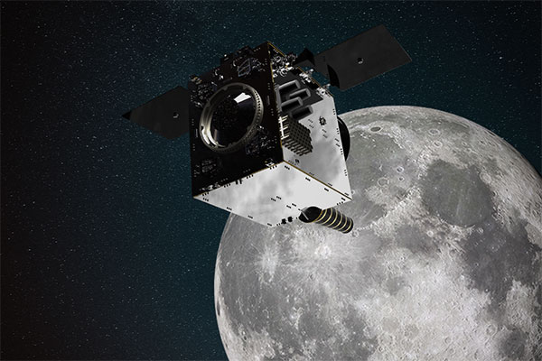
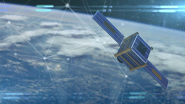
Artist’s impression of SSTL’s Lunar Pathfinder satellite that will provide communications services around the Moon. (Image: SSTL)
News from the European Space Agency (ESA)
ESA is going to the Moon — in collaboration with its international partners — and seeks to build a lasting lunar link to enable sustainable space exploration.
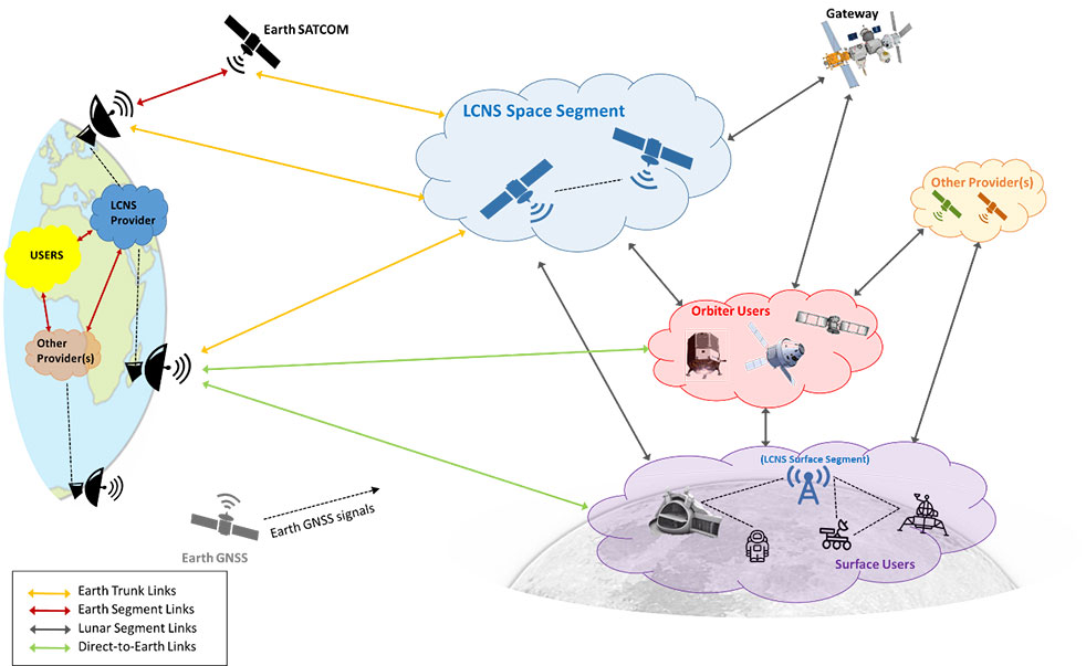
The agency has now evaluated initial ideas to create a network of lunar telecommunications and navigation satellites.
Creating a commercial telecommunications and navigation service for the Moon will allow many of the dozens of planned lunar missions to share the same infrastructure to communicate with Earth, as well as to find their way on the lunar surface.
The service is needed because the planned missions are becoming regular trips to Earth’s natural satellite rather than one-off expeditions.
Using a shared telecommunications and navigation service will reduce the design complexity and weight of individual missions, making them more cost-efficient.
Lowering the ticket price to lunar exploration could also empower a wider group of ESA member states to launch their own national lunar missions, inspiring the next generation of scientists and engineers.
Call for Ideas
The call for ideas for how to use a lasting link with the Moon is open until April 30. People working for commercial companies, universities or governmental organizations are welcome to suggest how they would like to use a lunar communications and navigation service.
This diagram presents a notional preliminary top-level system concept for a lunar communications and navigation service. (Image: ESA)
Concept Reviews Completed
Two consortia of companies have now completed their system concept reviews, which set out how to create the lunar constellation, under ESA’s Moonlight initiative to identify the best way to create a lasting link with the Moon. The reviews set out the business and technical analysis needed to identify and justify a number of feasible system concepts for creating the lunar network.
The next step will be to define a detailed system architecture and identify the most suitable partnership models between private space companies and ESA.
Telespazio leads the first consortium. The consortium includes:
satellite operators Inmarsat and Hispasat
manufacturing companies such as Thales Alenia Space Italy, OHB System in Germany and Canadian space technology company MDA
Italian Aerospace Logistics Technology Engineering Company (ALTEC)
small and medium-sized enterprises such as Nanoracks Europe and Argotec
universities and research centers such as SEE Lab, SDA Bocconi and Politecnico di Milano.
The second consortium is spearheaded by Surrey Satellite Technology Limited, both in the service prime capacity through its lunar services brand SSTL Lunar and as the satellite manufacturer. The consortium includes:
satellite manufacturer Airbus
satellite network providers SES, based in Luxembourg, and Kongsberg Satellite Services, based in Norway
the Goonhilly Earth Station in the UK
British satellite navigation company GMV-NSL.
Artemis Program and Pathfinder
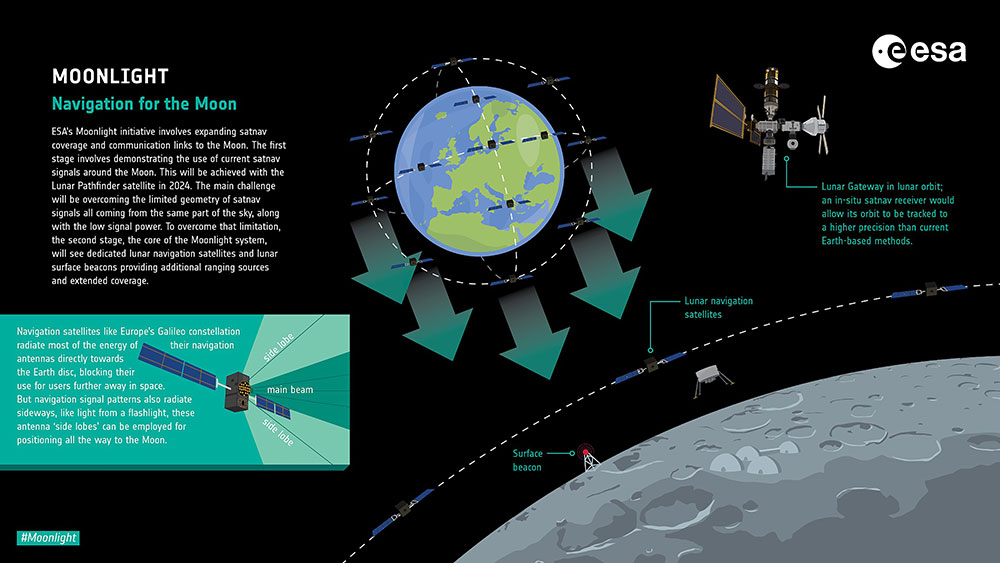
NASA’s Artemis program will use several of ESA’s service modules to return humans to the Moon, including the ESPRIT communications module for the lunar Gateway’s living quarters for astronauts. With its European industrial partner, ESA is helping to build the Lunar Pathfinder, showcasing lunar communications service provision by providing initial services to early lunar missions, including a complete lunar navigation in-orbit demonstration.
The Moonlight initiative builds on both the ESPRIT communications module and the Lunar Pathfinder.
A new Android app released by the European Space Agency (ESA) turns smartphones equipped with dual-frequency GNSS receivers into instruments for crowdsourced science.
The CAMALIOT app, developed through ESA’s Navigation Innovation and Support Programme (NAVISP) with the support of the GNSS Science Support Centre, is suitable for more than 50 smartphone models.
Using the CAMALIOT app, the phones will record small variations in satellite signals, gathering data for machine learning analysis of meteorology and space weather patterns.
As well as helping to create new Earth and space weather forecasting models, participants are also in with the chance to win prizes including new phones and Amazon vouchers. This four-month “citizen science” campaign runs until the end of July.
“The precisely modulated signals continuously generated by the dozens of GNSS satellites in orbit are proving a valuable resource for science, increasingly employed to study Earth’s atmosphere, oceans and surface environments,” said ESA navigation engineer Vicente Navarro. “Our GNSS Science Support Centre was created to help support this trend.”
For instance, tens of thousands of permanent GNSS stations are continuously recording GNSS data. As the satellite signals travel down to Earth they are modified by the amount of water vapor in the lower atmosphere, helping to forecast rainfall in particular.
GNSS signals also undergo delay and fading — known as scintillation — as they pass through irregular plasma patches in the ionosphere. This electrically charged upper atmospheric layer is continuously changing, influenced by solar activity, geomagnetic conditions and the local time of day. Dual-frequency GNSS receivers can compensate for this effect by comparing their two frequencies.
“The combination of Galileo dual band smartphone receivers and Android’s support for raw GNSS data recording is what opened up the prospect of supplementing data from these fixed GNSS stations with tens of millions of smartphones, vastly increasing our density of coverage,” Vincente said. “We took inspiration from the famous ‘SETI@home’ initiative, where home laptops help seek out signs of extraterrestrial life.”
The results can then undergo a Big Data machine learning approach, seeking out previously unseen patterns in both Earth and space weather.
“This is our first step in enlarging GNSS data acquisition using an internet of things data-fusion approach, employing novel sources such as fixed sensors and drones as well as smartphones,” Vincente said. “A wide range of other applications are also possible for the system, including improving the performance of GNSS systems.”
Formally known as the Application of Machine Learning Technology for GNSS IoT Data Fusion project, CAMALIOT is run by a consortium led by ETH Zurich (ETHZ) in collaboration with the International Institute for Applied Systems Analysis (IIASA).
“The CAMALIOT effort was underpinned by Element 1 of our NAVISP research programme, spurring innovation in satellite navigation,” said Pierluigi Mancini, ESA’s NAVISP program manager.
Monitoring the constantly changing shape of the sea surface is important for scientific and societal applications such as ocean current forecasting, climate research, ship routing, cable laying and debris tracking.
A project supported by the Discovery element of ESA’s Basic Activities recently investigated a technique to precisely measure sea-surface topography. The project was based on an idea submitted by the Institute for Space Studies of Catalonia (IEEC) through the Open Space Innovation Platform (OSIP) — ESA’s place for your space ideas.
The technique involves GNSS reflectometry — signals that have been reflected off of the sea surface at very low angles. At these “grazing” angles, waves and surface roughness have little impact on the reflection process; the sea surface acts as a very smooth mirror.
“In a mirror-like reflection the phase of the signal can be tracked — it is continuous,” explained IEEC’s Estel Cardellach, principal investigator and submitter of the OSIP idea. “Different surface heights result in different phase measurements. It gives a very precise measurement of the surface altitude at a few centimetres’ precision.”
Balearic Islands Project
The ESA-funded activity involved developing a GNSS receiver and setting up an experiment in the Balearic Islands to collect GNSS signals reflected off the sea surface. The team — made up of IEEC, imedea, SOCIB and DLR — then processed the signals for optimized measurements of the shape of the sea surface.
“Thanks to OSIP and ESA Discovery we have been able to conduct this experiment on grazing GNSS reflectometry under monitored conditions,” said Manuel Martin-Neira, ESA technical officer for the project. “We have linked the coherence of the reflected signals to wave height and the elevation angle of GNSS satellites. These results have been very useful for preparing the PRETTY mission.”
ESA’s PRETTY (Passive REflecTomeTry and dosimetry) CubeSat mission is a small satellite that will carry out grazing angle GNSS altimetry from orbit. It is due to launch later this year.
France has begun the Synchrocube project with an aim to provide a complementary service to GNSS. In the project, a low-Earth-orbit nanosatellite will provide synchronization functions when GNSS navigation signals are unusable.
Development of the Synchrocube is part of the French recovery plan for the space sector. Planned to be 6U in size (typically 20 × 10 × 34.05 cm), the satellite platform is being developed by Syrlinks, which will provide both the payload and the ground receiver necessary to provide the location and timing service.
Consortium
Besides Syrlinks, companies taking part in the Synchrocube project include U-Space, (nanosatellite platform supplier), Anywaves (miniature antennas for satellites constellations) and Comat (satellite instruments).
By pooling their technologies, the companies in this consortium demonstrate their ability to provide effective and competitive solutions to respond to ambitious space programs.
“Synchrocube represents a major evolution for Syrlinks,” said Guy Richard, Syrlinks CEO. “The implementation of a project as sizeable as this opens up new commercial prospects for the company. Syrlinks, initially known as a satellite subsystem manufacturer, is on its way to becoming a service provider.”
The Japan Aerospace Exploration Agency (JAXA) has selected a contractor for a study of positioning in space after an open-call competition.The study, part of “Development of Positioning and Communication Technology for Monthly Activities,” will consider possible lunar positioning satellite systems and ultra-long-range communication systems between the Moon and the Earth.
Artist’s rendering: NASA
JAXA is managing the project, with Ark Edge Space Co. Ltd. serving as the outsourcer for a consortium of companies and academia. Consortium members include Ark Edge Space, AAI GNSS Engineer Office, Kiyohara Optical Co. Ltd., KDDI Corporation, KDDI Research Institute, the University of Tokyo Graduate School of Engineering and Mitsubishi Precision Co. Ltd.
From Jan.1 to March 25, the consortium is studying a comprehensive architecture for positioning and communication systems that will be the basis of lunar exploration, including a lunar positioning satellite system that takes into account the ultra-long distance between the Moon and the Earth.
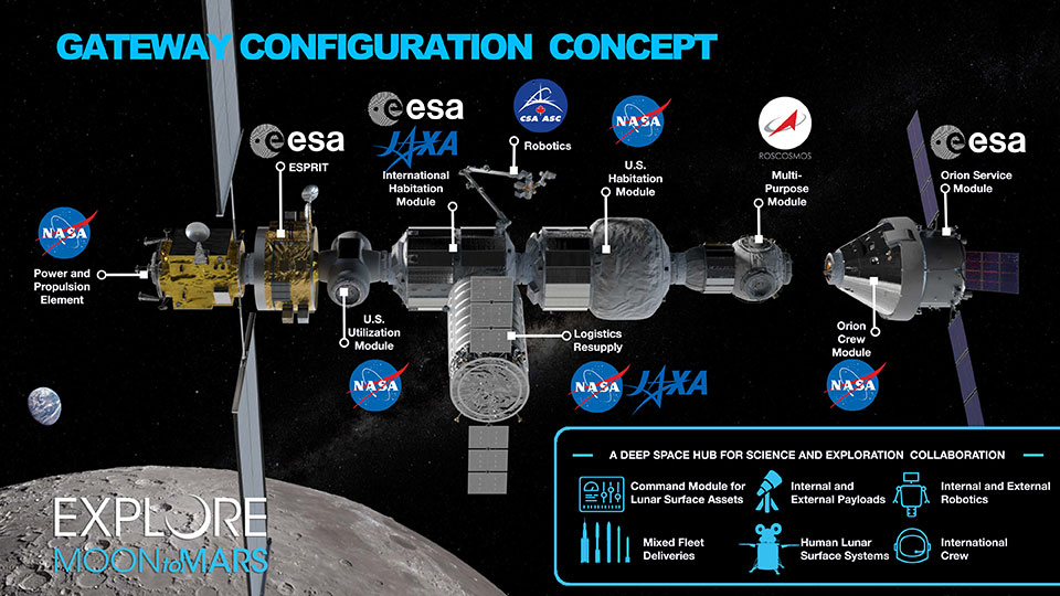
Map of the modules for the proposed Lunar Orbital Platform-Gateway station, to operate on the Moon and obtain construction within the 2020s. (Image: NASA)
Activities related to international lunar exploration and development are increasing, including the United States-led international Artemis Program, which plans for a manned lunar landing in 2025 and a manned Mars landing in the 2030s.
The Japanese government is participating in Artemis, joining other countries to build a lunar orbiting base named “Gateway.” Gateway will serve as a way station to support exploration of the lunar surface.
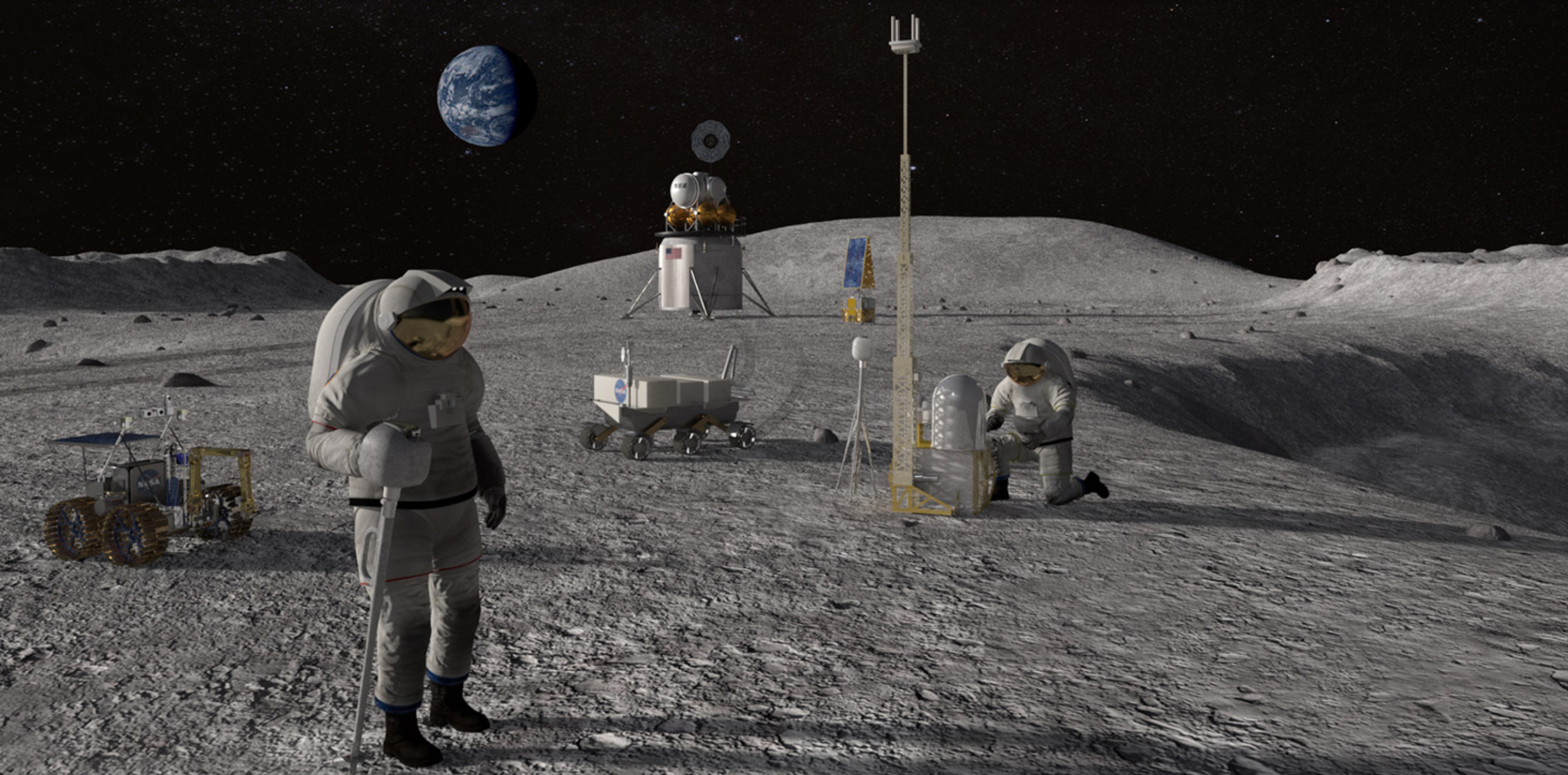
Feature image: Artist’s conceptualization of Artemis astronauts using lunar positioning and communications on the Moon. (Image: NASA/Resse Patillo)
Emcore Corporation has entered into a definitive agreement to acquire the assets and liabilities of the L3Harris Space and Navigation business for approximately $5 million in an all-cash transaction.
“L3Harris Space and Navigation designs and builds some of the most accurate navigation products in the world,” said Jeff Rittichier, president and CEO of Emcore. “This acquisition expands our fiber-optic gyroscope (FOG) product portfolio into the strategic grade and space-qualified markets. We will also gain a technical team with a sterling track record of development and production of high-performance FOGs, ring laser gyros (RLGs) and reaction wheels.
“This acquisition further solidifies Emcore’s position as one of the largest independent inertial navigation providers in the industry. This is an excellent fit strategically for Emcore, bringing space and navigation’s strong brand, inertial technology and important program wins. It also expands Emcore’s market reach into launch vehicle and space satellite markets, both of which are seeing significant growth,” Rittichier added.
“The L3Harris Space and Navigation team will provide Emcore with the capability to accelerate expansion into a true navigation-grade FOG business with superior performance and accuracy compared to competitors,” said Albert Lu, senior vice president and general manager, Aerospace and Defense for Emcore. “Combining this business into Emcore will allow us to provide customers with an expanded product suite that serves a broader range of requirements across both the tactical and navigation grade segments of the market.”
Highlights of the transaction are as follows:
Expands Emcore’s inertial navigation product portfolio and addressable market, accelerating growth and contributing additional revenue.
Includes master supply agreements (MSAs) for the BoRG (Booster Rate Gyro) and TAIMU (Tri-Axial Inertial Measurement Unit) launch vehicle programs and creates partnership opportunities with L3Harris to expand mutual business.
Adds Emcore as a preferred supplier to L3Harris divisions for future business opportunities.
Adds a complete set of capabilities to design and test for space applications:
shock, vibration and thermal-shock measurement equipment
x-ray capability and vacuum chambers.
Includes a large number of rate tables that can serve multiple product applications.
Is expected to create material operating synergies in engineering, manufacturing and sales.
Is expected to be non-GAAP EPS accretive.
Through the transaction, Emcore will acquire all the intellectual property and outstanding assets and liabilities of the L3Harris Space and Navigation business, including the 110,000-square-foot leased production facility in Budd Lake, New Jersey.
The consummation of the transaction is subject to customary closing conditions and is currently expected to close in the quarter ending June 30, 2022.
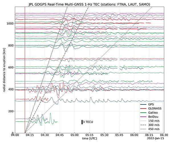
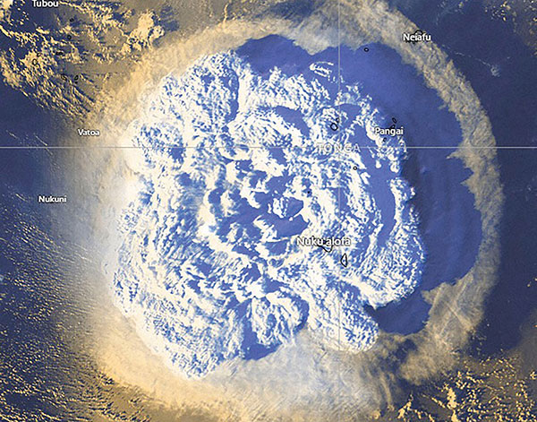
On Jan. 15, Hunga-Tonga-Hunga-Ha’apai, an uninhabited volcanic island on the Tongan archipelago in the South Pacific Ocean, erupted with spectacular force, churning ocean waters halfway across the globe.
GNSS engineers also detected its effects hundreds of miles above, in the ionosphere. The GNSS community is now moving from such after-the-fact detection to real-time monitoring using NASA’s Global Differential GPS (GDGPS) system, according to a team with the Tracking Systems and Application Section at NASA’s Jet Propulsion Laboratory (JPL) in Southern California.
“We monitored, in real time, four GNSS satellite constellations from numerous stations around the world using the GDGPS network. In particular, the three stations closest to the volcano, in Samoa, Fiji and Tahiti,” said postdoctoral associate Leo Martire. “We could see extremely high and strong signals in the ionosphere, which is very unusual. As a function of radial distance from the eruption, the first detected ionospheric perturbation likely originated directly from the explosion. Then we see patterns propagating at increasing distances at different radial propagation speeds.”
Monitoring such events adds information to the catalog of signals from natural hazards, pointed out Siddharth Krishnamoorthy, a research technologist who manages JPL’s GUARDIAN near-real-time tsunami warning system, currently under development. “That is useful because, in the future, if you want to be able to spot natural hazards and issue alerts, you need to know what the signal looks like. There have been reports of a tsunami in Tonga due to this event, so we will look at potential tsunami-induced signatures in the ionosphere. We are trying to get to a place where we pick up a signal like this and we are able to say, ‘This is a tsunami propagating at this speed and in this direction.’”
Chart: Jet Propulsion Laboratory
Before being detected in the ionosphere, signals from natural hazards must travel all the way from the surface. For tsunamis, this usually takes more than 10 to 20 minutes, but the volcanic eruption only took a couple of minutes to reach the ionosphere because it shot straight up. “We do not know yet, based on observations, how exactly different events on the surface caused by natural hazards couple with the atmosphere,” said research technologist Panagiotis Vergados. “Every event is unique in its spectral properties.”
The event did not affect the quality of GDGPS’s GNSS positions or orbits, because dual-frequency measurements remove significant ionospheric effects. “Instead of looking at the direct effects on the position of our available reference stations, which is what our traditional real-time monitoring does and which was basically negligible, imagine the links from each of those stations to a dozen or more satellites,” said Larry Romans, GDGPS chief technologist. “Every time one of those many links pierces the ionosphere, we can monitor that signal for ripples as waves go by. So, this is an incredibly powerful method for seeing disturbances, just in terms of the density of data. It is very complementary to position-based natural-hazards monitoring because the data is much richer.”
In addition to volcanoes and tsunamis, several other natural events, such as earthquakes and very large thunderstorms, also produce these effects. “These natural forcings cause large-scale, low-frequency pressure perturbations that tend to travel up and be visible in the ionosphere,” Krishnamoorthy said. “There are also perturbations of the ionosphere due to events from outside the Earth, such as solar flares or bolide impacts.”
Many of these perturbations start from the troposphere, which ranges between 10 km and 15 km in altitude — including hurricanes, which overshoot gravity waves all the way to the ionosphere, and thermal tides that have been observed to go all the way up to 600 km, said Vergados. “There are also geomagnetic storms and sub-storms that, during electron precipitation, can change the ionization of the ionosphere. So, the coupling can happen from either below or above or simultaneously, and then the effect can be dramatically enhanced.”
Most of the perturbations that come from below are of a pressure nature — that is, they start out as mechanical waves — while most of those that come from above are electromagnetic. “Aside from nuclear explosions, very large chemical ones, such as the 2020 Beirut explosion, also cause a signature on the ionosphere because they create very large pressure waves,” Krishnamoorthy said.
Photo: Tonga Meteorological Services, Government of Tonga
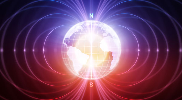
Dubai-based Intelligent Quantum Labs (Intqlabs) has announced that its latest proprietary technology of enabling location data solely from the Earth’s geomagnetic strength is now patent pending (UAE patent office application 202111049994).
Leveraging more than two decades of experience in developing antennas, sensors, radio analysis platforms and computing algorithms, the new technology incorporates advanced processes to calculate power profile data from magnetic readings. The power profile enables calculation of a location under water, in the air or on the ground within a few seconds.
The technology, dubbed New Global Navigation Satellite System (NGNSS), was developed to serve as an alternative to existing GNSS platforms such as GPS, GLONASS, Galileo, Beidou, QZSS and IRNSS. NGNSS does not depend on satellite constellation and is not susceptible to being jammed, injected, replayed or spoofed.
NGNSS operates on the core principle that every point on Earth’s surface and in its atmosphere has a uniquely calculable magnetic strength reading, or a geomagnetic force. This force changes based on distance from the poles, elevation, altitude, time of day, direction of sunlight, magnetosphere, earthquakes, inner core rotation, crust, declination, inclination, ionosphere, magnetosphere, and gyrations that occur in continuity such as solar storms, elevation, topography, altitude changes, spherical variations and regional anomalies
NGNSS removes interference and noise from geomagnetic readings by using a specialized array of aligned multiple input multiple output (MIMO) antennas connected to a complex network of embedded processors, extremely sensitive fluxgate sensors and other sensors. The antenna and embedded setup processes the magnetic strength reading to obtain the power profile, split the various signals in a profile, and then calculate the direction, origin and location of these sources. This enables NGNSS to identify the true strength of the Earth’s geomagnetic field by removing all sources of interference.
NGNSS is a secure platform unaffected by jamming, replay or injection as it monitors power profiles and simply drops the malicious data. Furthermore, NGNSS is independent of the GNSS constellations, making it a standalone, secure and “always available” platform that can be integrated within any electronic terminal by strategically embedding a chip and antenna.
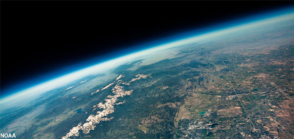
View from a weather balloon at 100,000 feet. (Photo: NOAA)
“We’re at 103,000 feet. As you look up the sky looks beautiful but hostile. …Can see for over 400 miles. The sky [above me] is absolutely black. …I can see the beautiful …deep, dark, indescribable blue [sky below], which no artist can ever duplicate. It’s fantastic.”
— Capt. Joseph W Kittinger, USAF, Operation Excelsior III, August 16, 1960
This month, our journey begins in the future. Imagine you are in Alamogordo, New Mexico, a town with a rich history in America’s space program. You are here for a proof-of-concept, real-world exercise. After two years spent training, you are on a team that will test the viability of a stratospheric airframe, or high-altitude platform station (HAPS).
The exercise is a joint venture between several large corporations and U.S. government agencies. The HAPS began as a telecommunications support platform, but now includes many different industries. It will test backup systems for GPS and other sensing technologies.
Remote sensing is an obvious use case, and sensors are onboard to collect hyperspectral and thermal images, synthetic aperture radar, lidar, magnetometry, weather and other types of data. Some equipment is mounted on top of the platform to point toward space to monitor satellites and orbital debris. Also aboard are are satellite relays and space-based communications systems. Additionally, a Hubble-like observatory will support NASA research.
On the ground at the command center, other teams are working on the project. A mapping and survey team is in the field to ground truth the precision, accuracy and resolution of the HAPS data.
Autonomous vehicle manufacturers are testing telemetry data from the HAPS for improved precision navigation. Teams of imagery analysts and geospatial analysts are assessing the quality and value of the products, including full-motion video live-streamed from the HAPS.
Aerospace engineers are studying the performance of the airframe and monitoring its structural integrity. Meteorologists are providing upper air wind and weather forecasts. Several teams of engineers are managing various robotics systems onboard, and more scientists and engineers from multiple companies and agencies are testing their equipment.
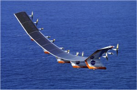
The solar-powered Helios in flight. (Photo: NASA/Aerovironment)
Your Mission as a Stratonaut
Most tests and modifications are being handled remotely, but some require replacing the systems. This can only be accomplished by physically going to the sub-orbital station. Imagine this is your job.
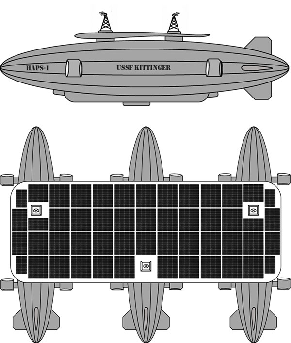
You are a remote sensing technician specially designated as a stratonaut. Your training familiarized you with the various systems onboard. You trained how to use your pressure suit — its dangers, risks and capabilities — and how to interface with the suit’s augmented reality system. You know how the HAPS operates, its schematics, and the interiors of the three connected dirigibles. You can navigate your way around the HAPS and access the various decks and compartments as well as the sensors, equipment, charging ports, fuel cells and motors. You can fly the drones, dock with the station, and enter its hangar bays. You can do maintenance on the autonomous robots and the remote-controlled robots onboard the station. You know the security and safety protocols. All this you know and more; and, if things go wrong, you know what to do.
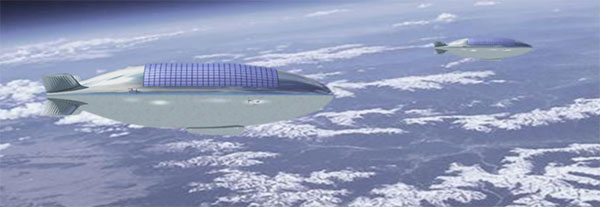
Vision of the Alpha, Bravo and Charlie HAPS stations. (Image: William Tewelow)
On this mission day, it’s early morning. Sunlight is beginning to pierce the sky above the Alamogordo base station. Two technicians are helping you into your pressure suit. Another technician at a desk has your helmet hooked up to the computer. The LED lights encircling the facemask blink slowly, indicating data is being uploaded. The augmented reality face shield glows a soft blue as the data flashes across it.
Overnight at the command center, operators controlled descent of the HAPS from 100,000 feet. It takes 10 hours to reach 65,000 feet, the altitude for your rendezvous with the station. You will fly up to the HAPS in a cargo delivery drone and dock at the forward hangar bay of Station Bravo (the second dirigible). You’ll be installing an enhanced high-resolution hyperspectral sensor array in the station’s lower observation deck.
While you are busy with the installation, the autonomous robot onboard will be in the hangar bay, swapping out the station’s spent fuel cells with fresh ones carried up by the cargo drone. Each weighs 250-pounds. After this task, the cargo drone will fly to Stations Alpha and Charlie and swap out their spent fuel cells.
Once all three are completed, the cargo drone will return to Station Bravo and take you to the top of Station Charlie to install a satellite laser relay (SLR) communications system. A remote-controlled robot operated by the engineering team at base command will meet you and carry the SLR up to the tower. While you are installing the SLR, the cargo drone will dock and recharge for your return trip. The entire mission will take seven-hours and 45 minutes.
“Many functions currently done with satellites could be performed for tactical and operational commanders using near-space assets, much more cheaply and with much greater operational utility. By operationally grouping near-space with space, the functional expertise synergies would allow much more efficient delivery of space effects to the joint commander.”
— Lt. Col. Edward B. Tomme, Ph.D., USAF, Air Power Research Institute
Two Types of Pseudolites
High-altitude, long-endurance (HALE) airframes — also referred to as pseudo-satellites, pseudolites and stratolites — are of two types.
Heavier than air. The heavier-than-air (HTA) type is a lightweight, fixed-wing aircraft with extremely long wingspans. It can stay aloft for a month or more.
HTAs are limited to carrying small payloads. They typically rise to 100,000 feet during the day powered by their solar cells, and at night descend to 60,000 feet, repeating this cycle until the batteries need replacing. The HTA platform is good for short-term missions over a broad area of interest because it normally flies in large circular patterns.
Lighter than air. The other type of pseudo-satellite is a lighter-than-air (LTA) airframe. The typical example is a dirigible, but these platforms can take on many shapes and sizes. LTAs can be enormous, with lifting capacities upward of 100,000 pounds. They operate as geostationary platforms loitering indefinitely over an area of interest and remain at the same altitude day and night. An LTA can last for 10 years or more.
The best solution is a combination of the two. A large LTA can serve as a base station to support several small HTA platforms.
“Together, NASA and the Space Force seek to advance, protect and sustain activities in, from and to space. This is truly a new era of strategic collaboration that will benefit commercial, civil and national security in space.”
— John W. Raymond, General, Chief of Space Operations, United States Space Force
A stratosphere-based telecommunications platform proposed by the Elefante Group. (Image: FCC)
HAPS Alliance
Furthering the development of the pseudo-satellite industry is a consortium of 49 companies and universities called the HAPS Alliance, which advocates for investment in this area.
The stratosphere has become increasingly important for commercial interests and national security. HAPS can provide the best of what manned aircraft operating at lower altitudes can offer, combined with the benefits of satellites, minus much of the downside of each.
Limits of aircraft. Aircraft operating at lower altitudes offer high resolutions and targeted collection. They can be easily retasked and rerouted, and equipment can be easily repaired or replaced. Aircraft are limited by constraints of time, fuel, weight, distance and weather.
Limits of satellites. Satellites, on the other hand, provide broad area coverage and long-term, operational endurance, but they are 240 miles or more above the Earth traveling at 17,500 miles per hour, or they are 18,000 miles above the Earth to maintain a geostationary orbit. It is a trade-off between resolution and dwell time.
Other drawbacks of satellites are their expense. Launching is costly and recovery is nearly impossible to make repairs. Doing so is impractical.
HAPS do not have those limitations. They can provide long-term, persistent operations over an area of interest at very high resolutions. They also can carry a complete package of sensors and equipment with the additional benefit that most everything can be repaired or replaced with minimal cost.
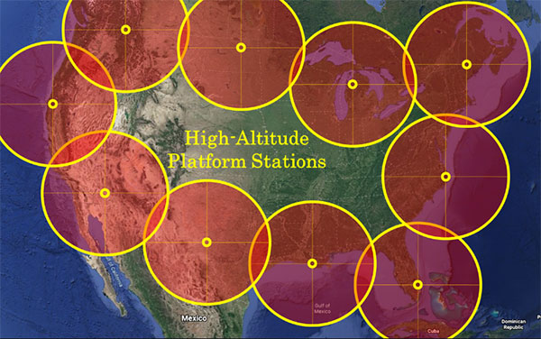
Locations of HAPS to cover the borders of the Continental United States. (Image: William Tewelow)
How HAPS Will Improve Geospatial Data
These systems are going to improve geospatial information. HAPS will improve spectral resolutions by a factor of 10x or better. The improved location accuracy data will impact navigation, surveying, construction, emergency services, logistics, transportation, aviation, agriculture and most other industries.
The HAPS will act in tandem with cellular networks on the ground to improve internet connectivity and telecommunications. They will improve national security while monitoring the effects of climate change, deforestation, urban sprawl, ozone, pollution and natural disasters such as floods, forest fires, tornadoes, hurricanes and more.
Provided testing proves HAPS a success, the pseudosatellite era is going to greatly impact most everyone’s life. If you are lucky, you might actually become a stratonaut. If you are interested, now is the time to prepare.
“This point of observation commands an area nearly 50 miles in diameter. The city, with its girdle of encampments, presents a superb scene. I have pleasure in sending you this first dispatch ever telegraphed from an aerial station.”
— Thaddeus S. C. Lowe, First Chief Aeronaut, Union Army Balloon Corps, Civil War, 1861
William Tewelow
William Tewelow is a Senior Aeronautical Information Specialist for the Federal Aviation Administration. He is a designated Geographic Information Systems Professionals (GISP). He served on special assignment to the U.S. Department of Transportation and led a national strategic geospatial initiative under the authority of the White House Open Data Partnership. He was among the first in the nation to earn a Geospatial Specialist Certification from the U.S. Department of Labor while working at NASA Stennis Space Center.
He is a 2016 graduate of the FAA’s management fellowship Program for Emerging Leaders. He has degrees in Geographic Information Technology and Intelligence Studies and is earning a master’s degree in Organizational Leadership with a focus on Performance Management. He is a mentor with the FAA’s National Mentor Program.
Tewelow retired from the U.S. Navy after serving 23 years as a Geospatial and Imagery Intelligence Specialist, a Naval Aviator, a Meteorologist, and a Tactical Oceanographer earning three achievement medals. He is married, enjoys traveling, connecting people, solving problems, and interested in new technology. His favorite quote is, “A man’s mind changed by a new idea can never go back to its original dimension.” ~ Oliver Wendell Holmes
New radiation-tested, tactical-grade MEMS inertial accelerometers designed for spacecraft electronics testing
Silicon Designs Inc. has launched the Model 1527 series, a family of miniature, radiation-tested, tactical-grade micro-electromechanical (MEMS) inertial accelerometers.
Offered in three full-scale acceleration ranges — ±10 g, ±25 g and ±50 g — the series is designed to support a variety of critical space electronics testing requirements, including those of spacecraft, satellites and CubeSats.
In addition, their small bias and scale-factor temperature coefficients, excellent in-run bias stability, and zero cross-coupling make the Model 1527 series particularly well-suited for spacecraft electronics testing applications requiring low power consumption (+5 VDC, 6.5 mA), low noise, long-term measurement stability in –55° C to +125° C environments, and performance reliability under intermittent radiation exposures.
Radiation test report data, as generated during internal qualification testing, is available on request.
The rugged design of the Model 1527 series combines a tactical-grade MEMS inertial sense element with a custom integrated circuit, internal temperature sensor, onboard sense amplifier and ±4V differential analog output stage. The MEMS inertial sense element and internal components are housed within a lightweight, hermetically sealed, nitrogen-damped, miniature, RoHS compliant, J-lead LCC-20 surface mount ceramic package (U.S. Export Classification ECCN 7A994), weighing 0.68 grams.
Its compact and lightweight footprint allows for ease of accelerometer installation within space-constrained environments, as well as minimization of mass loading effects. Each Model 1527 Series accelerometer is marked with a serial number for traceability on both top and bottom surfaces.
All Silicon Designs’ Model 1527 Series tactical-grade MEMS inertial accelerometers are designed, manufactured, performance-verified and calibrated in-house at the company’s global corporate headquarters and R&D center outside of Seattle, Washington. Product performance documentation is supplied at the time of shipment, including residuals, thermal sensor model, acceleration model, bias, scale factor, linearity, operating current and frequency response data.
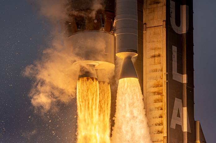
Space Systems Command, together with United Launch Alliance and other mission partners, successfully placed the fifth and sixth Northrop Grumman-built Geosynchronous Space Situational Awareness Program (GSSAP)-5/-6 satellites into orbit for the U.S. Space Force, after an on-time launch aboard an Atlas V rocket from Space Launch Complex (SLC)-41 at Cape Canaveral Space Force Station, Florida, at 2 p.m. EST (11 a.m. PST).
“The evolving threat to our space environment requires new levels of resiliency and survivability, autonomy and automation, and unprecedented levels of integration and networking,” said Lt. Gen. Michael A. Guetlein, commander of Space Systems Command. “Today’s successful launch will enhance our capabilities in space domain awareness and our space-based space domain awareness architecture. Congratulations to the USSF-8 integrated team and all mission partners on a successful launch.”
The GSSAP-5/-6 satellites join a constellation supporting U.S. Space Command’s space surveillance operations as a dedicated Space Surveillance Network sensor.
GSSAP also supports the Combined Force Space Component Command by collecting space domain awareness data, allowing for more accurate tracking and characterization of manmade orbiting objects. GSSAP is led by SSC’s Special Programs directorate.
The National Security Space Launch (NSSL) mission launched aboard ULA’s Atlas V in the “511” configuration, which was comprised of a five-meter diameter payload fairing from RUAG Space, a single Graphite Epoxy Motor (GEM)-63 solid rocket booster from Northrop Grumman, and a single RL-10 engine from Aerojet Rocketdyne on the Centaur upper stage.
SSC’s Launch Enterprise acquired the launch service through ULA and was responsible for successfully placing the GSSAP satellites on orbit.
The NSSL program provides assured access for the United States’s critical warfighting space assets, and this launch vehicle has reliably placed valuable assets into their intended orbits repeatedly, adding to the NSSL program’s success record of 88 consecutive launches. The program supports a full range of government mission requirements for the nation’s defense and intelligence sectors.
Space Systems Command is the U.S. Space Force field command responsible for rapidly identifying, prototyping and fielding resilient space capabilities for joint warfighters. SSC delivers sustainable joint space warfighting capabilities to defend the nation and its allies while disrupting adversaries in the contested space domain. SSC mission areas include launch acquisition and operations; space domain awareness; positioning, navigation and timing; missile warning; satellite communication; and cross-mission ground, command and control and data.
A ULA Atlas V rocket carried the USSF-8 mission for the U.S. Space Force into orbit, (Photo: ULA)
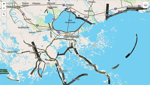
Hurricane Ida assessment imagery and data are now available. Ida was a Category 4 Atlantic hurricane from Aug. 26 to Sep. 4. (Screenshot: NOAA)
Applanix, a Trimble Company, and the National Oceanic and Atmospheric Administration (NOAA) have collaborated to provide critical information to first responders in the wake of Hurricanes Henri and Ida.
Applanix’s high-accuracy direct georeferencing (DG) technology enabled NOAA to quickly collect aerial mapping imagery to
provide valuable disaster remediation information to first responders
demonstrate the value of mapping technology in preparing for and responding to emergency situations such as hurricanes, tornadoes and other disasters.
Within hours of Hurricanes Henri and Ida making landfall, NOAA’s National Geodetic Survey collected post-storm imagery using the latest generation Digital Sensor System (DSS). The sixth-generation DSS, designed and manufactured for Applanix by Lead’Air, is the most powerful to date, thanks to several new features introduced within the solution:
simultaneous full color and near-infrared image capture using high-performance Phase One iXM 100 MP NIR and 150 MP RGB cameras
option to fly the cameras in wide coverage oblique or traditional overhead (straight line down) mode for mapping with uninterrupted measurement
embedded Trimble AP60 GNSS + inertial OEM DG solution for mapping without the need for ground control or aerial triangulation
Applanix POSPac post-processing software featuring the Trimble post-processed CenterPoint RTX correction service (PP-RTX) for centimeter-level mapping without GNSS reference stations
in-air development of raw imagery to JPEG-ready files for creating map products immediately upon landing
Lead’Air’s X-Track flight management, which enables the system to be flown outside of planned flight lines to follow roads, rivers and coastlines.
Applanix’s DG technology suite provides direct GNSS inertial georeferencing, meaning that all pixels in the aerial images taken by NOAA are mapped at their exact location on the ground.
“We have worked with Applanix for nearly 20 years,” said Michael L. Aslaksen Jr., chief of the remote-sensing division, NOAA’s National Geodetic Survey. “The level of sophistication they bring to aerial imagery and mapping keeps our team at the forefront of the industry. Their customer support team is always open to new ideas, new innovations and doing whatever it takes to get the job done.”
First responders have access to this imagery and mapping within 24 hours via the cloud (as does anyone at storms.ngs.noaa.gov) and can map detailed response plans based on highly accurate data highlighting where the greatest need lies.
Access to this turnkey emergency response imagery is available to any federal agency, municipality, insurance company or other entity that depends on highly accurate information to plan for and recover from disasters.