Category: Survey

  • Why users will need to perform GNSS occupations as part of a leveling project after 2022

    Why users will need to perform GNSS occupations as part of a leveling project after 2022

    This column will address why users will be required to perform GNSS occupations when submitting a leveling project to the National Geodetic Survey (NGS) after 2022. It will highlight a section of NGS Blueprint for 2022, Part 3, “Working in the Modernized NSRS,” that discusses the process of performing leveling projects after 2022. My October 2017 column briefly discussed NGS’ preliminary plans for incorporating geodetic leveling data into the North American-Pacific Geopotential Datum of 2022 (NAPGD2022) to establish orthometric heights consistent with GNSS-derived NAPGD2022 orthometric heights. It emphasized that after NAPGD2022 is established, the primary means for deriving orthometric heights on monuments will be using GNSS observations combined with the geoid model.

    As a side note, NGS just released NOAA Technical Report NOS NGS 72–GEOID18, a report that provides a comprehensive explanation of the data and methods used to create the latest NGS hybrid geoid model. My February 2020 column provided an analysis of the differences between the latest published hybrid Geoid18 values provided on NGS’ Datasheet and the computed geoid height value using the published NAD 83 (2011) ellipsoid height and NAVD 88 orthometric height.

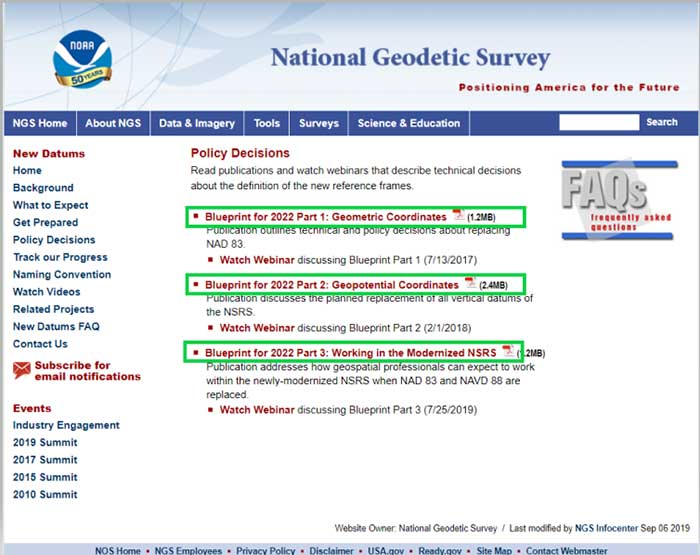
    In support of the modernization of the National Spatial Reference System (NSRS), NGS has published three documents denoted as Blueprints for 2022 that describe the modernization of the NSRS (see the box titled “NSRS Modernization NGS Blueprint Documents”).

    NSRS Modernization NGS Blueprint Documents

    (https://www.ngs.noaa.gov/datums/newdatums/policy.shtml)

    Image: National Geodetic Survey
    Image: National Geodetic Survey

    There are several sections in NGS Blueprint for 2022, Part 3, “Working in the Modernized NSRS,” that discuss the process of performing leveling projects after 2022. Something that will be new after 2022 is that NGS will require users to perform GNSS occupations in order to incorporate their leveling results into the new modernized NSRS.

    NGS realizes that in the immediate future GNSS will not replace geodetic leveling for determining the most accurate local orthometric height differences. NGS’ plans include preparing a new leveling manual that will explicitly explain how to work in the modernized NSRS. Some of the new surveying procedures are described in Section 2.10 of Blueprint part 3. In section 2.10, NGS states that there will be substantial changes in how they process and serve up survey data, and that there will be some new ways of executing surveys. This column will focus on sections “2.10.2 Leveling” and “2.11.5 Leveling on Passive Marks” that discuss the new procedures for executing leveling surveys in the modernized NSRS. One major change is that leveling surveys will require Global Navigation Satellite System (GNSS) occupations to ensure orthometric heights computed in leveling surveys are up-to-date and are connected to the NSRS through the NOAA CORS Network. After the modernization of the NSRS in 2022, the NOAA CORS Network will be the primary access to the NSRS. This means leveling and classical surveys will require GNSS surveys to be part of the project. NGS’ plans include creating an OPUS option for processing all types of surveys. Users will be able, within OPUS, to adjust their projects using any mix of CORS data and passive control. Saying that, these same projects, on submission, will be deconstructed at NGS and reduced to the raw observations, then adjusted solely to the NOAA CORS Network to determine Final Discrete coordinates every GPS Month. The GPS Month concept may be new to some users. Blueprint Part 3 describes the concept in section “2.11.3 GNSS on Passive Marks.” The basic concept of a GPS Month is that it is four consecutive GPS weeks, with the first week in the GPS month having a GPS week number that is a multiple of four (see box titled “Definition of a GPS Month”).

    Definition of a GPS Month

    GPS month: Four consecutive GPS weeks, with the first week in the GPS month having a GPS week number that is a multiple of 4.

    In this fashion, NGS defines:

    • GPS month 0 = GPS weeks 0, 1, 2, and 3 (1/6/1980 through 2/2/1980)
    • GPS month 1 = GPS weeks 4, 5, 6, and 7 (2/3/1980 through 3/1/1980)
    • GPS month 2 = GPS weeks 8, 9, 10, and 11 (3/2/1980 through 3/29/1980)
    • GPS month 513 = GPS weeks 2052, 2053, 2054, and 2055 (5/5/2019 through 6/1/2019)
    • etc.

    So, what does this really mean to the user when performing a leveling project in 2022? For a leveling project to be processed using NGS software and/or submitted to NGS for inclusion into the NSRS database, the user must follow specific rules.

    The following is from Blueprint, Part 3, section “2.10.2 Leveling:”

    “As GNSS occupations are required for geodetic leveling, the rules for how many and how frequently will be:

    • For a leveling project to be processed using NGS software and/or submitted to NGS for inclusion into the NSRS database, its field observations should not span more than one year. Longer projects should be broken into sub-projects of less than one year.
    • A minimum of three “primary control marks” must be in the level network for every project.
    • More primary control marks should be added so there is never more than a 30-kilometer linear distance between marks in the entire network.
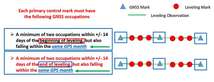
    • Each primary control mark must have the following GNSS occupations (details on using GNSS occupations to work in the NSRS will be found in the update to NGS 58):
      • A minimum of two occupations within +/- 14 days of the beginning of leveling, but also falling within the same GPS month and whose local start times are separated by between 3 and 21 hours.
        • It is preferable, but not required, that all occupations on any primary control mark occur within the same GPS month as those of all other primary control marks.
      • A minimum of two occupations within +/- 14 days of the end of leveling, but also falling within the same GPS month and whose local start times are separated by between 3 and 21 hours.
        • It is preferable, but not required, that all occupations on any primary control mark occur within the same GPS month as those of all other primary control marks.
    • All projects exceeding six months must have a third set of GNSS occupations on all primary control marks some time near the middle of the project, without a rigorous rule as to when. They must follow the “minimum of two occupations” rule as per above, and each mark’s occupation is required to fall in the same GPS month, with a preference that all primary control marks are occupied in the same GPS month.”

    The box titled “GNSS Procedures for Leveling Projects” highlights the GNSS rules that need to be adhered to when performing leveling projects in 2022.

    GNSS procedures for leveling projects

      • For the Immediate Years Following 2022, NGS Will Require That all Leveling Projects Turned in Have GNSS on Primary Control
        • Minimum of 3 Points with a Maximum Spacing of 30 km
        • At Least Two Occupations of Each GNSS Primary Control:
          • +/- 14 days of Beginning of Leveling
            • Within the Same GPS Month
          • +/- 14 days of Ending of Leveling
            • Within the Same GPS Month

    Image: National Geodetic Survey
    Diagram: David B. Zilkoski

    The boxes titled “GNSS + Leveling 2022 Procedures at the Start of the Leveling Project” and “GNSS + Leveling 2022 Procedures at the End of the Leveling Project” provide conceptual diagrams that illustrate what this means to a typical leveling project.

    Image: National Geodetic Survey
    Diagram based on information from Dan Gillins, NGS, and modified by David B. Zilkoski
    Image: National Geodetic Survey
    Diagram based on information from Dan Gillins, NGS, and modified by David B. Zilkoski

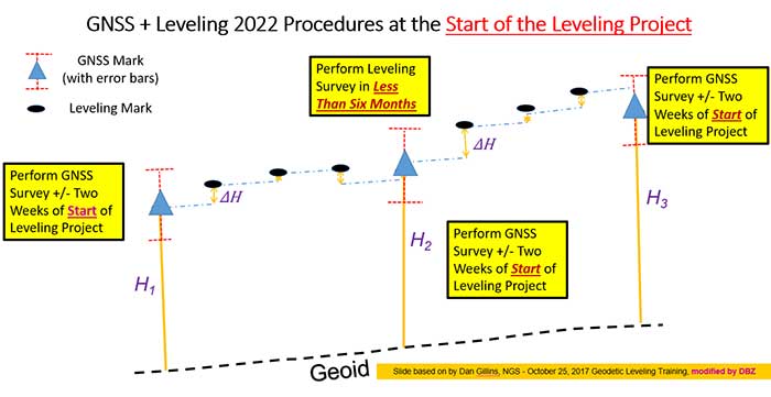
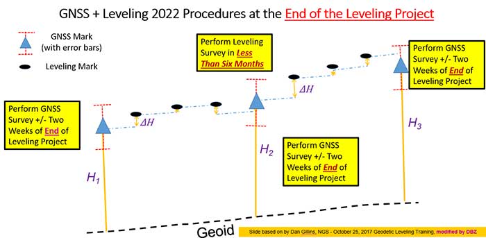
    So, why is NGS requiring users to perform GNSS observations in support of leveling project. Leveling is a differential measurement technique; it generates relative height differences not absolute heights. In NGS’ modernized, time-dependent 2022 NSRS, the absolute height will be provided by up-to-date GNSS data; and the accurate relative height differences between leveling marks will be provided by the leveling data. (See box titled “Why NGS Requires GNSS Occupations on Primary Marks.”)

    Why NGS requires GNSS occupations on primary marks

    • The Connection to NAPGD2022 is Obtained Through GNSS and a High-Accuracy Geoid Model
    • Network Accuracy
    • The Accuracy of the Height Differences are Provided Through the Leveling Data
    • Local Accuracy
    • Combining the leveling and GNSS increases the redundancy in a survey network

    NGS is developing models and tools to facilitate the incorporation of leveling survey data and adjustment results into the new modernized NSRS in 2022. Blueprint, Part 3, section “2.13.3 OPUS for Leveling,” describes NGS plans to support leveling surveys through the use of the OPUS web tool. The box titled “OPUS for Leveling” outlines how NGS will modify the OPUS web tool to support leveling surveys.

    OPUS for leveling

    • Support for leveling surveys will follow many of the best aspects of OPUS
      • Uploading and processing digital data files
      • Using a web-based graphical interface
      • Submitting data to NGS
    • Leveling is a differential measurement technique
      • It generates relative height differences not absolute heights
    • For users who need absolute heights in the NSRS
      • OPUS will support a mix of GNSS and leveling in a single project
    • NOTE: NGS will require a GNSS survey to be performed at specific times before and after leveling surveys in order for the data to be submitted for inclusion in the modernized NSRS after 2022.
    • NOTE: Leveling surveys longer than one year must be broken up into multiple projects. Leveling surveys between 6 and 12 months in duration require a third, intermediary GNSS data collection.

    This column highlighted that in the modernized NSRS the only way to get “into the datum” will be through a GNSS survey. It noted that leveling projects generate relative height differences not absolute heights. In NGS’ new modernized, time-dependent NSRS, the absolute height will be provided by up-to-date GNSS data; and the relative height differences between leveling marks will be provided by the leveling data. A major requirement will be that users must collect GNSS data both at the beginning and at the end of a leveling survey project. Leveling survey projects that take longer than one year to complete must be broken up into multiple projects. NGS is developing model and tools to facilitate incorporating all types of survey data into the new NSRS. I would encourage all readers to read NGS’ Blueprint for 2022 documents to obtain a better understanding of the new, modernized NSRS.

  • Sonardyne chosen for Brazilian geoscience research vessels

    Sonardyne chosen for Brazilian geoscience research vessels

    Sonardyne logoBrazilian geoscience services company OceanPact Geociências has chosen deep-water positioning technology from Sonardyne Brasil Ltda. to support its geophysical, geotechnical and environmental research operations across the region.

    Ranger 2 ultra-short baseline (USBL) systems have been installed on board OceanPact’s research vessel Seward Johnson and RSV Austral Abrolhos to precisely track the location of underwater equipment and sensor packages deployed from the ships, including seabed corers, towed sensors and data loggers. Both vessels are currently on hire to Brazilian oil major Petrobras.

    Ranger 2 USBL is a popular choice for conducting research at sea as operations can start as soon as a vessel arrives on location. This helps maximise valuable ship time. It has the capability to track multiple underwater targets simultaneously to beyond 11 kilometers, works in shallow or deep water and is able to remotely configure and communicate with compatible instruments. This operational flexibility was a key factor in OceanPact’s investment decision.

    “This order from OceanPact further embeds Ranger 2’s reputation in the region. For those wanting accuracy and versatility, it’s proven itself time and again while also meeting the toughest specifications from oil and gas, science and survey companies,” Andre Moura, sales and applications manager at Sonardyne Brasil Ltda.

  • CHC Navigation introduces AT661 GNSS geodetic antenna

    CHC Navigation introduces AT661 GNSS geodetic antenna

    Cost-effective, high-performance antenna designed for GNSS networks and monitoring applications

    Photo: CHC Navigation
    Photo: CHC Navigation

    CHC Navigation has released the AT661 geodetic antenna for GNSS networks or monitoring applications. The AT GNSS antenna series is the result of years of expertise in GNSS technologies. The compact geodetic GNSS antenna offers performances rivaling those of high-cost and bulky conventional GNSS choke ring antennas, according to CHC Navigation.

    The AT661’s supports all current and future GNSS signals, including GPS, GLONASS, BeiDou, Galileo, QZSS, IRNSS, SBAS and L-band. The antenna features both high-gain LNA and wide beamwidth to provide excellent flexibility in applications requiring low-elevation satellite reception and high availability of GNSS signals, especially in obstructed situations.

    “By further integrating the design and manufacture of GNSS antennas, CHC Navigation is broadening its presence as a global provider of GNSS solutions.” said George Zhao, CEO of CHC Navigation. “Mastering the entire GNSS positioning and navigation value chain allows us to deliver the performance our customers demand at the price they expect.”

    The accuracy of the antenna’s phase center reaches the millimeter level with extremely high stability and repeatability to ensure perfect processing of GNSS data regardless of the length of the baselines.

    Built to last, the AT661 withstands all types of weather, including high and low temperature fluctuations, and is protected by a waterproof radome.

  • Mount Everest survey complete, results still to come

    Mount Everest survey complete, results still to come

    The survey team and sherpas reach the top of the world. (Photo: CHC Navigation)
    The survey team and sherpas reach the top of the world. (Photo: CHC Navigation)

    China’s field work for new measurements of Mount Everest — the world’s, highest peak — are now complete. However, it will take two to three months for scientists to calculate and release its exact height, according to CHC Navigation, whose GNSS receiver was used.

    The eight-member Chinese survey team reached the summit on May 27. The team erected a survey marker and installed a GNSS antenna on the snow-covered peak. The team also conducted a GNSS survey, snow depth measurement and gravity survey, said China’s Ministry of Natural Resources.

    Scientists will use multiple traditional and modern measurement techniques to perform comprehensive calculations of the measurement data. After data analysis and processing, they will carry out theoretical studies and repeated verifications to determine the accurate height. Complex calculations are needed to eliminate errors caused by factors such as temperature, air pressure and the refractive environment.

  • CHC Navigation’s GNSS receivers reach Everest peak

    CHC Navigation’s GNSS receivers reach Everest peak

    CHC Navigation’s P5 geodetic GNSS receiver was successfully used by a Chinese team of surveyors to complete the 2020 Mount Everest Elevation Survey.

    This is the first time that a team of Chinese surveyors has climbed the summit of Mount Everest, and it is also the first time that BeiDou-based Chinese GNSS receivers have been used to measure the height of Mount Everest, known in China as Mount Qomolangma.

    China's National Geodetic Survey Team and its Mountaineer's Team. (Photo: CHC Navigation)
    China’s National Geodetic Survey Team and its Mountaineer’s Team used CHCNAV GNSS receivers. (Photo: CHC Navigation)

    The Everest Project

    To promote research on the Mount Everest elevation and to ensure the scientific character and accuracy of measurements, the Ministry of Natural Resources mobilized the Shaanxi Bureau of Topography and Geographic Information Mapping from the Chinese Academy of Topography and Mapping to plan and implement the measurements of the Mount Everest elevation. China’s National Geodetic Survey Team and its Mountaineer’s Team would undertake the arduous climb.

    The plan set out the technical guidelines and required that the Everest Elevation Project be designed to achieve innovative and technological breakthroughs in several areas of research.

    The first is to use the BeiDou satellite navigation system to perform GNSS measurements; the second is to use Chinese surveying and mapping equipment to complete the task.

    Meeting Harsh Challenges

    In October 2019, CHCNAV received a request from the Ministry of Natural Resources to provide GNSS equipment for the 2020 Everest Elevation Project. A dedicated team combining different departments, from R&D to manufacturing, was set up. The team elaborated the specific technical requirements from the National Survey engineers, in particular the difficulties and challenges related to the altitude of Everest.

    Measuring the height of Mount Everest, especially the summit, is a challenge, not only for the limitation of the human body in such elevation environment, but also for the performance of the GNSS receiver itself.

    At over 8,800 meters, the minimum temperature can reach -45°C and the atmospheric pressure is only 30 kPa (compared to the normal 101 kPa). All the surveying equipment used is exposed to both low temperature and low-pressure constraints.

    In addition, the operation of the instruments must be as simple and reliable as possible in such an extreme environment. Surveyors wear thick winter clothing and lack oxygen, making every movement an extreme challenge. Finally, the measurement of the mountain peak must be completed at the first attempt, as re-measurement is impossible.

    CHCNAV's P5 geodetic GNSS receiver. (Photo: CHC Navigation)
    CHCNAV’s P5 geodetic GNSS receiver. (Photo: CHC Navigation)

    Rugged Solution

    To meet these stringent requirements, CHCNAV has provided GNSS receivers that have passed the most rigorous environmental and reliability tests. The entire solution, from the GNSS receivers to the accessories, has been optimized to ensure mission success from the very beginning.

    A wide temperature range of material — supporting an operating temperature range of –45°C to +85°C — were used, including redesigned lithium-ion batteries offering 12 hours of operation even at extremely low temperatures. Also used were antenna cables with a specific compound material to avoid any cracking or signal attenuation.

    To ensure reliable operation of the receivers in a low-pressure environment, the GNSS receivers have built-in waterproof and breathable valves to maintain internal and external pressures. The low-pressure tests replicated a 25-kPa environment, corresponding to an altitude of 10,000 meters.

    Additional ruggedized reinforcement prevented damage in the event of accidental receiver drop thanks to a robust design to keep the display and connectors safe. Following CHCNAV tests, third-party organizations were commissioned to perform environmental testing and reliability verification, including storage and operating at high/low temperatures, vibration, shock, rain, dust, humid heat, salt and fog.

    From November 2019 to March 2020, CHCNAV’s GNSS equipment was supplied to the National Photoelectric Rangefinder Testing Center — under the requirements of the China Academy of Surveying and Mapping — for the most rigorous evaluation. As a result, the company’s GNSS receivers were selected to provide the peak altitude measurements of Everest in 2020.

    The climb to the summit. (Photo: CHC Navigation)
    The climb to the summit. (Photo: CHC Navigation)

    Reaching the Summit

    On April 5, 2020, at the Everest Elevation Survey Expedition Ceremony in Lhasa, CHCNAV officially donated GNSS equipment to the National Survey Team. Both product and technical training was provided to the team.

    The 53 members of the first National Survey Team overcame the difficulties related to the environment, bad weather and the additional impact of COVID-19, and conducted a series of measurements on Mount Everest and surrounding areas such as level, gravity and GNSS.

    Thirty of the 60 points of the GNSS control network were measured with CHCNAV GNSS receivers, including three of the seven Everest elevation intersection points.

    On May 27, the CHCNAV GNSS receivers finally reached the summit and successfully completed the task.

    The successful achievement of the Everest elevation measurement reflects the performance of the Chinese surveying and mapping industry, confirms BeiDou as a major part of the GNSS systems, and demonstrates the technical success of CHCNAV as a major player in the GNSS industry.

    About CHC Navigation

    Founded in 2003, CHC Navigation is a publicly listed company creating innovative GNSS navigation and positioning solutions. With a global presence across the world, distributors in more than 100 countries, and more than 1,300 employees, CHC Navigation is today recognized as one of the fastest-growing company in geomatics technologies.

  • Pointfuse and Leica Geosystems enter development agreement

    Pointfuse and Leica Geosystems enter development agreement

    Photo: Pointfuse
    Photo: Leica Geosystems

    Pointfuse and Leica Geosystems, a Hexagon company, have established a global cooperation and entered into a development agreement. According to the companies, the agreement aims to streamline the use of reality capture in established digital construction, space management and visualization workflows.

    This strategic cooperation demonstrates the shared focus of Pointfuse and Leica Geosystems to democratize technology and create intuitive and accessible reality capture tools that bring advanced project efficiencies to their users, the companies added.

    To launch the new cooperation, Pointfuse developed a new version of its Pointfuse software, powered by Jetstream, that provides Leica Geosystems users with a Scan-2-BIM workflow within the Leica Jetstream ecosystem. Pointfuse is configured with tailored profiles specifically for Leica Geosystems 3D laser scanners, including the Leica Geosystems LGS file format. The adoption of the LGS file format enables Pointfuse to extract data contained within the LGS file to assist in the classification of building information and substantially automate the workflow process. This centralized solution ensures a simple Scan-2-BIM workflow for space and facilities management as a companion solution to the new Leica BLK2GO handheld imaging laser scanner, the companies said.

    “With functionality and developments implemented specifically for Leica Geosystems users, Pointfuse, powered by Jetstream, harnesses the unique benefits of the Jetstream ecosystem with the power of Pointfuse to deliver a seamless capture-consume-collaborate workflow,” said Steve Salmon, general manager at Pointfuse. “This integrated solution overcomes many of the barriers associated with laser scanning and photogrammetry, through providing an optimised storage solution, instant data loading and production of intelligent outputs. This platform enables Leica Geosystems users to exploit the intelligence captured in the point cloud, easily share outputs, and produce deliverables that drive the advancement of workflows in the digital age.”

  • Harxon debuts ruggedized antenna HX-CVX600A for i-construction machining applications

    Harxon debuts ruggedized antenna HX-CVX600A for i-construction machining applications

    Ruggedized GNSS antenna HX-CVX600A. (Photo: Harxon)
    Ruggedized GNSS antenna HX-CVX600A. (Photo: Harxon)

    Harxon has launched a ruggedized GNSS antenna for applications subject to high shock and vibration environments such as i-construction machining applications. Integrated with reliable signal tracking and strong anti-interference performance, the IP69K ruggedized HX-CVX600A antenna provides end users with millimeter accuracy, durability and productivity, the company said.

    I-construction promotes the use of automated machines on construction sites to improve productivity and provide support to workers.

    The Harxon HX-CVX600A offers full support for reliable and consistent satellite signals tracking, including GPS, GLONASS, Galileo and Beidou, QZSS, IRNSS and SBAS, as well as L-band correction services.

    By exhibiting a very stable phase center that adopts multipoint feeding technology, exceptional low elevation satellite tracking with symmetric radiation patterns, high gain with ultra-low signal loss, as well as outstanding wide-angle circular polarization (WACP),  the Harxon HX-CVX600A performs with remarkable positioning accuracy and provides end users with full control of the job site, performing tasks more productively, meeting tighter positioning specifications, and avoiding rework caused by inaccurate positioning.

    The HX-CVX600A GNSS antenna of Harxon also provides superior anti-interference performance. Its advanced low noise amplifier (LNA) excels in improved signal filtering and out-of-band rejection and restrains electromagnetic interference. It also provides strong multipath reduction capacity over all GNSS frequency bands for consistent and reliable GNSS signals, even under complicated environments such as congested urban areas or communication base stations.

    The Harxon HX-CVX600A compact and low-profile antenna is Harxon’s first antenna with exceptionally firmness for hash operation environment as construction industry. The upper cover of the antenna is made of material with excellent chemical and high heat resistance. Its aerodynamic enclosure withstands exposure against dust, rain, splash or sunlight. Screws and pole mounts are both available, offering flexible installation.

    The Harxon HX-CVX600A ruggedized antenna is now open for pre-sale; contact [email protected].

  • CHC Navigation introduces Apache3 marine drone

    CHC Navigation introduces Apache3 marine drone

    Highly cost-effective autonomous marine drone for bathymetric surveys

    Photo: CHC Navigation
    Photo: CHC Navigation

    The new Apache3 Marine Drone — 2020 Edition provides a series of new features and additional enhancements to make lake, river and coastal hydrographic surveys more productive, according to maker CHC Navigation.

    Combining a dual GNSS positioning and heading sensor, a stable and reliable hull attitude and an inertial measurement unit (IMU) sensor, the Apache3 unmanned surface vehicle (USV) allows an uninterrupted survey while passing under bridges.

    Its high-efficiency 8-meters-per-second motors and absolute straight-line technology enable a fully automatic, predetermined course in adverse current conditions.

    The Apache3 features include:

    • GNSS/INS control box to maintain high accuracy during transient GNSS outage
    • Integrated 4G and LAN transmission module
    • Sonic radar for obstacle avoidance
    • Automatic return to base planning
    • 360° PTZ camera (pan, tilt, zoom)
    • Overspeed engines to allow operation in most water conditions

    According to CHC Navigation, the Apache3 — 2020 Edition offers an exceptional feature/price ratio, making it one of the most competitive professional marine UAV solutions for single-beam bathymetric surveys.

    Photo: CHC Navigation
    Photo: CHC Navigation
  • Trimble beta tests new construction OS

    Trimble beta tests new construction OS

    Trimble WorksOS is an upcoming civil construction software-as-a-service (SaaS) operating system. The cloud-based system will integrate data from Trimble and third-party providers across the entire civil construction project lifecycle, including estimating, scheduling, designs and the field.

    Beta testing is now taking place for WorksOS, before it is released in the third quarter. Users interested in participating can go to WorksOS.trimble.com.

    One-Stop Software. With WorksOS, site supervisors and project managers will be able to log into a single application to track daily production quantities, labor and equipment hours, and equipment maintenance schedules. They will be able to view real-time visibility of cut, fill, volume and compaction data to maximize jobsite productivity.

    A user-friendly dashboard enables key personnel, including site supervisors, to adjust daily work targets to ensure work is progressing to plan. Site supervisors will also gain live daily volume calculations, compaction quality metrics and visibility into which machine is working, to monitor progress and determine if the project is on schedule.

    Software Connections. Connecting workflows, Trimble WorksOS will integrate Trimble Business Center, Trimble WorksManager, Trimble Siteworks Positioning System, Trimble Earthworks Grade Control Platform and Trimble PULSE Fleet and Equipment Management Software.

    Screenshot: Trinble
    Screenshot: Trimble
  • SPH Engineering announces bathymetric drone solution

    SPH Engineering has launched a new product to make bathymetric surveys of inland and coastal water.

    The system — an unmanned aerial vehicle (UAV) integrated with an echo sounder — is time- and cost-efficient. It is suitable for mapping, measuring and inspecting tasks as well as environmental monitoring.

    The system allows field workers to collect data with high accuracy quickly. It is easily transported, quickly deployed and twice as cost-efficient as traditional methods.

    The UAV/echo sounder system can be operated in hard to reach locations, and unsafe or hazardous environments. Locations not reachable by foot or that are dangerous for a human (steep coasts, mining pits, contaminated waters, terrain obstacles, etc.) as well as waters of ponds, lakes, and canals can be reached by the drone.

    “Since autumn 2018 we have been getting bathymetry-related requests,” said Lexey Dobrovolskiy, CTO of SPH Engineering. “Analyzing about 150 inquiries, we have come to the conclusion that a drone-based solution could open a new business opportunity for drone service companies to do bathymetry surveys of coastal and inland water, especially those for industrial needs.

    “Compared with a standard approach using a boat or an unmanned surface vehicle, a drone could save a lot for its user,” Dobrovolskiy said. “An echo sounder itself could be integrated into a client’s drone with no need to purchase additional equipment. Moreover, it is small and easy to transport and operate. At the same time, such research method guarantees data accuracy and employee safety.”

  • Surveying and COVID-19: A lesson in essential services

    Surveying and COVID-19: A lesson in essential services

    Open space: the final frontier. These are the voyages of the professional surveyor and their crew. Their mission: to explore and survey strange new lands. To retrace old boundaries and to create new parcels and subdivisions. To boldly go where no one has gone before (unless it has been previously surveyed and platted…)!

    With a nod to Star Trek fans (and apologies to Mr. Roddenberry), the surveyor has been the terrestrial version of the Captain Kirk and Science Officer Spock, exploring existing and uncharted territories. While most surveys completed in the modern day are retracements of previous parcels, there are still areas where surveyors are completing various tasks where no one has been before.

    There are very few instances where a survey is performed near others. By this simple fact, one can argue that the surveyor is the original social distancer. The real question, however, lies within the determination of the value of the surveyor and if the work we perform is an “essential service.”

    This article is not attempting to debate the value of the surveyor versus all the first responders, doctors, nurses, healthcare personnel and the hardworking employees doing their best to keep up with our basic needs. We are here to discuss the challenges faced by the surveyor and how technology has provided much-needed tools for crossing this abyss of doom and despair called COVID-19.

    But first, let us talk about how we arrived at this extraordinary time for nearly everyone on the planet.

    Photo: LeoPatrizi/E+/Getty Images
    Photo: LeoPatrizi/E+/Getty Images

    Worldwide upheaval or some close facsimile thereof

    Every generation has a historical event, moment or era for which they remember exactly what they were doing:

    • “Greatest” generation (born before 1924): the Stock Market crash of 1929 and subsequent depression
    • “Silent” generation (born 1925-1945): Pearl Harbor and World War II
    • Baby Boomers (born 1946-1964): Korean War, the Kennedy assassination, the Moon landing and the Vietnam War
    • Generation X (born 1965-1980): Reagan assassination attempt, Challenger explosion, death of Princess Diana
    • Millennials (born 1981-1996): 9/11, Aurora and Sandy Hook shootings

    Unfortunately, the series of events leading up to the nationwide shutdown because of the COVID-19 pandemic will unseat most of those events and eras. While previous pandemics (for instance, the Spanish flu of 1918) struck and killed many more people, the mobility of today’s population coupled with instantaneous media coverage provides a much different environment for this situation.

    Image: CDC.gov
    Image: CDC.gov

    Obviously, we are not alone, and this virus has spared few countries and races. Different cultures across the globe have adapted for the pandemic in a variety of ways, and the U.S. has faced the same challenges across our diverse environments.

    Depending on where one is located, they face a different set of challenges due to the pandemic. Several heavily populated urban areas are subject to a strict lockdown while states with mostly rural areas are less restrictive. One size does not fit all when dealing with limiting public exposure to others, but let us leave the debate of how much restriction is needed to the scientists and public officials. Many today do not agree with the rules we have been dealt with in going about with our lives. That is a discussion for another time and different forum.

    Instead, let us discuss what we face going forward with our “new reality” of some form of social distancing and how the need for surveying and geospatial information remains for a large portion of this world. We must simply adapt to this situation with the adoption of new technologies and a revamped workflow.

    Everything changes, whether we like it or not

    The surveying profession is not unlike many other service-oriented and public-serving occupations, even with most of the field work being performed in solitude. We still deal with clients, governmental agencies, other consultants and the public.

    The COVID-19 pandemic has changed the way we are now interacting with those outside partners with technological advances and modified communication conduits. Many of these methods existed well before this situation, but the rapid advancement of the pandemic forced many companies and employees into adapting very quickly.

    Surveyors are no different, so let us run through the changes we have seen within the industry.

    Project communication

    The biggest challenge facing most surveyors in dealing with the pandemic atmosphere has been communication. Whether it is with employees, clients, government agencies or other consultants, communication has been affected mostly because of the elimination of face-to-face opportunities.

    Technology to allow remote communication has existed for many years, but not many of us have taken advantage of it because of the convenience of in-person interaction. Who does not want to leave the office to meet with a client, shake their hand and close the deal? Or have the client come to your office and go over the intricacies of a complex survey?

    Regardless of whether one is introverted or extroverted, human contact has always helped establish and solidify relationships. For most of us, this is how business has always been done, be it your client or your employees.

    Obviously, the biggest area affected has been daily interaction with employees. Controlling workflow, handling projects and troubleshooting any situation is more difficult when the team is not physically in the same location. If a team member is overwhelmed, another one can immediate meet with them and help. Work is easily passed between teammates with little effort.

    But working remotely? That takes more effort, consideration and technology to accomplish. Yes, video conferencing has been in place for many years, but mostly in large companies and only implemented it in a dedicated conference room. Not many employees were previously afforded a webcam, microphone and speakers along with the necessary software; all of these components are now standard issue. For many, programs like Zoom, Skype and Microsoft Teams are now a critical communication tool for timely and efficient sharing of information.

    What about communication with field crews? Many would say that even a pandemic would not change how we stay in touch with field crews, but even these relationships have been affected. While there are survey companies operating with limited physical contact as a norm (large firms with projects regionally or nationwide), most surveyors still have a substantial amount of direct communication between field and office. This situation has forced many firms to take precautions, with crew members only handling specific pieces of equipment or performing a thorough cleaning if sharing during a project.

    Project documents and files have typically been been handled manually with some electronic data files being transferred via email or internet. Depending on the size of the original document, having a full-size paper copy of a previous survey or subdivision plat has advantages to looking at a PDF image on a tablet or computer screen while in the field. Many companies outfit their field crews with 11 x 17-inch printers to be able to print larger detailed areas of bigger documents. Additional care must be taken if these items will still be used for field operations.

    Image: Tim Burch
    Image: Tim Burch

    The transfer of data between office and field has become faster, more efficient and safer with technology. As data collectors have become more capable, direct connections via the internet to cloud storage is making transfer of project files and photos faster and more secure by providing immediate backup to guard against data loss. What used to take a trip to the office, connecting to a computer and downloading is now done in a matter of minutes without leaving the job site.

    Field personnel are also benefiting from technology within our devices. Apps like FaceTime and programs like Microsoft Teams provide a gateway to video chatting so teammates can discuss projects in real time. Shared pictures, computer screens and face-to-face interaction provides an avenue to more effective communication and enhancing relationships between team members.

    The pandemic has forced many surveyors to adapt and learn several new apps and programs to connect in new ways; however, this pandemic has also affected how we go about our field operations, too.

    Enhanced data collection

    Not many of the surveyor’s field activities are affected because of social distancing requirements, but the pandemic has forced our profession to be compliant with the new rules in case we are in proximity with others. Newer technology, using both terrestrial and aerial platforms, are now being utilized by more surveyors for their data collection needs.

    Train employees now. As many companies have seen a slowdown in work due to pullbacks from projects moving forward, now is the time to get employees trained with the new technology and software to be better prepared for when the market comes back.

    Using photogrammetry tools. Photogrammetry, lidar and laser-scanning systems are being purchased and implemented for everyday use and not just “special” projects with larger budgets. Not only are surveyors finding it keeps them further away from other people, it also allows for more efficient data collection and representation of existing conditions.

    Flying unmanned aerial vehicles. UAVs continue to grow in popularity, and like the other technology discussed above, many firms are investing in becoming remote pilots and implementing aerial photography and lidar into their workflow. Previously, most surveyors (and the general public) would use Google Earth, Bing and other resources for aerial imagery to gain a better perspective on their project sites. Vendors are coming out with aerial products with more recent flights at a higher resolution, but do not offer the ability to extract reliable topographic data easily. In-house UAVs provide more flexibility and control over the information needed, and many are using their downtime to become familiar with aerial products.

    Photo: GPS World
    Photo: GPS World

    Dipping toes into remote sensing. Another sector of surveying equipment seeing increased use during this situation are new total stations with remote-sensing capability. Many surveyors may not have the need for a standalone laser or lidar scanner, so several manufacturers have introduced a total station that provides limited remote sensing for everyday use. While the built-in scanner is not nearly as robust as a traditional remote-sensing unit, it provides enough capability and accuracy for most users. This intermediate step of remote sensing helps a firm decide how much scanning they will produce and if an investment in a full function unit is right for them.

    Upgrading GNSS receivers. We would be amiss if we did not mention that more surveyors are now upgrading their GNSS receivers to take advantage of more constellations, integration with IMUs and increased computing power of the latest data collectors. Some surveyors who are not as economically affected during this pandemic are taking advantage of great deals on new equipment and using this time to increase their capability and efficiency. As more satellite vehicles become available, the ability to gain accurate and precise locations is better than ever, so staying ahead of technology is still important in these times. We will continue to see more gains with L5 and L1C signals from the new GPS Block III satellites within the next few years, so staying current now is very important.

    QA/QC — The electronic method

    One trouble spot seen within the new paradigm is the ability to provide a thorough quality assurance/quality control (QA/QC) process on all surveying operations. Without the ability to print/plot original surveys at full scale, it becomes a more difficult procedure to review and analyze information on a computer screen.

    The monitors used for drafting and calculations are getting bigger, but studies have shown the human eye will focus differently on an electronic screen compared to a survey on paper. There must be many other professions and occupations using similar technology who have yet to solve the QA/QC dilemma. Hopefully, our industry will find a way to help address this issue and provide guidance.

    Image: Tim Burch
    Image: Tim Burch

    More connected than ever, yet still so alone

    The COVID-19 pandemic of 2020 (let us hope that is all it encumbers) will be forever etched in our memories as frightening and unbelievable. More than 100 years has past since the last pandemic of this proportion has overwhelmed our population. We are much more advanced in our education of health, medicines and technology than the previous event, yet we were caught off-guard by the speed in which the virus spread throughout our lands. It taxed most of our health infrastructure beyond its limits and took its toll emotionally and financially to most of the population.

    We were forced to adapt very quickly to a new norm of working remotely and independently of our co-workers and teammates. Did it hurt our productivity and profitability initially? Absolutely. Were our employees forced to learn new ways of doing their work and communicating by other means. Yes, they did. Was there a need for rapid troubleshooting of new procedures and task management? Of course. Has every transition of remote work been a success story? I doubt it, but it was not for lack of trying.

    We are doing the best we can, and the surveying profession is rapidly trying to adapt. Like the rest of the world, the surveying profession will not be the same coming out of the restrictions placed upon us because of the pandemic. We have learned more about ourselves and how capable we are with tools we have. We also learned how we will transition with these skills into new technology not invented yet.

    Surveyors are a tough bunch, so the social distancing and adaptation required to survive the COVID-19 pandemic of 2020 — while not easy by any stretch — has been handled with grace and professionalism. I would say to bring on the next one, but would rather this pandemic be in our rearview mirror quickly and not see anything like it ever again.

  • CenterPoint RTX Fast now available coast to coast in US, Canada

    CenterPoint RTX Fast now available coast to coast in US, Canada

    One-inch GNSS accuracy in under a minute, delivering seamless high-precision performance across the U.S. and southern Canada

    Trimble has completed expanding its CenterPoint RTX Fast correction service, with coverage now spanning the contiguous U.S. and southern Canada. This expansion is central to Trimble’s vision to transform how and where users can leverage precision and accuracy.

    Coverage of Centerpoint RTX Fast. (Image: Trimble)
    Coverage of Centerpoint RTX Fast. (Image: Trimble)

    Designed for autonomous applications in both on-road and off-road markets, the coverage and performance of the service enables industry professionals to re-think what is possible when using augmented positioning for improving safety, performance, productivity and operational efficiency.

    See full coverage maps here.

    The CenterPoint RTX Fast subscription service delivers horizontal positioning accuracy of 1 inch (2 centimeters) or less in under a minute, with the versatility of satellite or cellular delivery. This expanded coverage makes it the largest, high-performance GNSS correction network in the world, according to Trimble.

    Base stations not required. The service encompasses more than 5 million square miles across North America and Europe. By using the service, said Trimble, farmers, land surveyors and GIS professionals can untether from the cost and complexities of GNSS base stations.

    In addition, Trimble RTX Fast offers a single, continuous correction technology platform for enabling a broad range of safety-critical autonomous applications in markets such as automotive, agriculture and construction.

    “This achievement is a major milestone in the continuous evolution of our correction service and autonomy strategy. We are delivering unmatched access to fast, reliable, highly accurate positioning in more areas than ever before,” said Patricia Boothe, senior vice president of Trimble’s Autonomy Sector. “Whether enhancing performance in the autonomy ecosystem or simplifying traditional mapping and surveying workflows, RTX Fast users can gain greater accuracy to improve productivity and operate safely — ultimately transforming the way they work and drive.”

    CenterPoint RTX Fast subscriptions for Trimble RTX-compatible GNSS receivers are available through Trimble’s Authorized Business Partners or Trimble’s online store.