Category: Transportation

  • An inside look at Trimble’s new product suite

    An inside look at Trimble’s new product suite

    Photo: Trimble
    Photo: Trimble

    From May 14 to 16, more than 1,400 attendees gathered at the Huntington Convention Center of Cleveland, Ohio for Trimble’s Innovate 2024 User Conference.

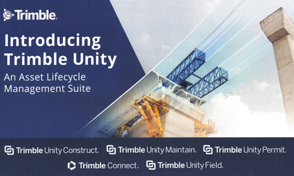
    At the conference, Trimble announced its upcoming asset lifecycle management suite, Trimble Unity. The software suite offers comprehensive capabilities that enable owners to efficiently plan, design, build, operate and maintain their assets.

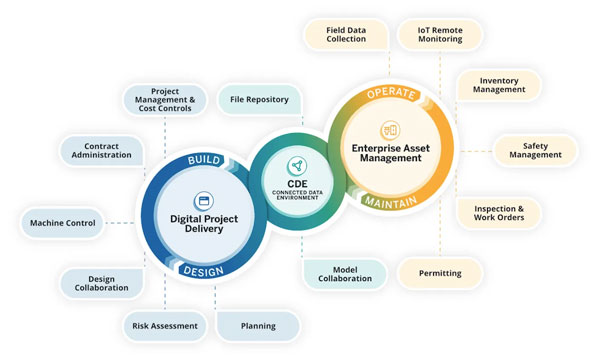
    Trimble Unity provides an end-to-end solution that connects teams across all lifecycle phases, giving them access to critical data to make decisions. From designers, engineers and contractors to asset managers, inspection and maintenance crews, Trimble Unity offers all stakeholders visibility to reliable data across digital workflows that help foster collaboration, improve project outcomes and reduce the total costs of asset ownership.

    Trimble Unity capabilities includes:

    • Trimble Unity Construct: A cloud-based construction project and program management capability that provides insights to improve process control and reduce cycle times. It is powered by Trimble e-Builder.
    • Trimble Unity Maintain: An enterprise asset management capability that streamlines work activity, planning and analysis to optimize resource allocation and infrastructure reinvestment. It is powered by Trimble Cityworks AMS, Trimble AgileAssets and Trimble Unity Work Management.
    • Trimble Unity Permit: A permitting, land management and licensing capability for streamlining public and back-office operations required to manage permits, licenses, right-of-way and code enforcement. It is powered by Trimble Cityworks PLL.
    • Trimble Connect: A connected data environment that unifies asset data in files, native file formats and 3D modes to streamline accessibility and collaboration.

    In addition, Trimble Unity includes Trimble Unity Field, an all-in-one mobile application enabling field workers to design, build and maintain assets more efficiently, leading to improved productivity, reduced technology costs and improved community confidence.

    GPS World met with Senior Vice President for Trimble’s Owner and Public Sector, Cyndee Hoagland, for an exclusive interview about the new product suite, how GIS plays a pivotal role in the asset management lifecycle and more.

    Photo: Trimble
    Photo: Trimble

    What sectors can benefit from this new product suite?

    For the public sector side, federal, state and local governments. Think cities, municipalities, state departments of transportation (DOTs), airports and transit authorities. For the private sector, healthcare facilities and universities.

    Is Trimble adding any new capabilities to the applications within the suite?

    We added a GIS capability to e-Builder along with Trimble Unity Field, so the mobile application of e-Builder is new. We did not have a capability for location-based information within the application itself, but it is now included, which is the added GIS capability.

    How do data strategy and GIS play a role?

    Most of our users on the enterprise asset management side are GIS-centric, having GIS and GPS experience. They recognize and understand the value of location data combined with asset data. For example, it is so much better for an inspector to know the location of bolts that need to be repaired before the work begins.

    Additionally, from a GIS perspective, if you are thinking about the GPS elements, and location and spatial data relative to an asset from the planning stage, through design and construction all the way to operation and maintenance, that data can be used to more efficiently operate and maintain the asset over its lifecycle. This asset lifecycle management approach allows the owner to reduce their total cost of ownership for that asset by as much as 40%.

    Do you have an example?

    Let’s say a bridge costs $1 million to plan, design and construct. Historically, $3 million would then be spent on operations and maintenance across the bridge’s service life, bringing the total cost of ownership of the bridge to $4 million. However, using an asset lifecycle management approach, owners can reduce that $4 million cost by up to 40 percent, saving $1,600,000 on the total cost of ownership of that bridge.

    These enormous savings are possible because owners can track the location, condition and attributes of the bridge throughout the asset lifecycle and use that information to make better decisions for managing the asset. Owners can access information such as the location of the bridge, the type of asphalt used to build it, the geometry of all the components that create that bridge and more. All that asset-specific information is available in a GIS geolocated model, which is highly valuable not just for the owner, but for the design and contractor teams along the entire asset lifecycle.

    Are there benefits of using a mobile mapping platform to collect data as opposed to using a UAV?

    They serve different purposes. UAVs go up in the air at key points in a project to give owners an update on the project performance and how much is getting completed.

    Another way of capturing rich asset data quickly is mobile mapping and terrestrial laser scanning. What you will see, for example, is that a state DOT will have to provide information to the Federal Highway Administration (FHWA) relative to all their lane miles. In large scale projects, a vehicle-mounted mobile mapping system can be used to capture highly accurate and immersive asset data at highway speed. That data will then go into an asset management system, where it can help users prioritize where the road repairs need to take place.

    Will artificial intelligence (AI) be integrated into this suite in the future?

    AI is already being used today to transform large amounts of real-world data into information. If an owner has collected data to inspect a bridge, for example, the highly accurate and rich data from mobile mapping and UAV systems can show an owner where exactly repairs are needed. The datasets are, however, extremely large, and AI built into processing and analysis software can help reduce tedious tasks, such as extracting features. This streamlined analysis of the data helps to inform owners on how to best manage and maintain their assets.

    The key capabilities of the Trimble Unity Asset Lifecycle Management Suite will be available beginning in June 2024.

  • SandboxAQ unveils AI and quantum-powered navigation system

    SandboxAQ unveils AI and quantum-powered navigation system

    Photo: SandboxAQ
    Photo: SandboxAQ

    SandboxAQ has released AQNav, designed for navigation across air, land and sea when GPS signals are jammed or unavailable.  

    As of June 2024, AQNav has logged more than 200 flight hours and 40 sorties across multiple regions of the world on four different aircraft types, ranging in size from single-engine planes to large military transport aircraft. 

    AQNav is a geomagnetic navigation system that uses proprietary artificial intelligence (AI) algorithms, powerful quantum sensors and the Earth’s crustal magnetic field. The system seeks to provide an un-jammable, all-weather, terrain-agnostic, real-time navigation solution in situations where GPS signals are unavailable, denied or spoofed.  

    The system uses extremely sensitive quantum magnetometers to acquire data from Earth’s crustal magnetic field, which exhibits geographically unique patterns – similar to a human fingerprint. AQNav uses AI algorithms to compare this data against known magnetic maps, allowing the system to quickly and accurately find its position. Due to the high sensitivity of quantum sensors, AI algorithms are applied to improve the signal-to-noise ratio, removing any mechanical, electrical or other interference that would impact the system’s ability to acquire its location. 

    It is available globally and can be used in air, land and sea applications. The system does not rely on visual ground features or satellite transmissions to function and is not affected by weather conditions.  

    AQNav operates at room temperature, requires no shielding and has a small form factor that can be integrated into a wide variety of platforms, from multi-engine airliners to UAVs. Its passive technology emits no electronic signals, which reduces the aircraft’s detectability. 

    AQNav seeks to increase useful navigation for aircraft navigating within the frameworks of regulatory bodies such as the International Civil Aviation Organization and the Federal Aviation Administration (FAA). SandboxAQ and its partners are continuing to explore a broad range of use cases for both commercial and defense applications. 

  • HERE Technologies launches fleet optimization package

    HERE Technologies launches fleet optimization package

    Photo: HERE Technologies
    Photo: HERE Technologies

    HERE Technologies has launched its Fleet Optimization software package, designed to enhance the efficiency and scalability of fleet management operations.  

    The Fleet Optimization package aims to meet the needs of the transportation and logistics industry. It offers location-based features using HERE’s artificial intelligence (AI) to tackle the complexities of routing operations for commercial fleets.  

    The package is a robust set of location-based application programming interfaces (APIs). The key components and features of the HERE Fleet Optimization package include: 

    • HERE Tour Planning uses map content and complex routing scenarios that consider real-time and historical traffic, alongside vehicle and road restrictions, to provide optimal deployments of multi-vehicle commercial fleets.  
    • HERE Routing creates optimized, safe and accurate navigation solutions customized to truck, light commercial vehicle and two-wheeler routing profiles. 
    • HERE Geocoding and Search validates and enhances the accuracy of addresses and optimizes route planning through precise geocoordinates, ensuring fleet movements are based on the most accurate and current data available. 
    • HERE Map Rendering offers up-to-date, detailed map data, in raster and vector formats, with rich attributes used specifically by commercial vehicles — including road restrictions, bridge heights, road topology and topography. This feature offers drivers visualization and cues for reliable commercial vehicle navigation. 

    A key benefit of the package is the incorporation of variables such as vehicle profiles, driver availability and delivery schedules, to provide instantly optimized tours and more precise estimated time of arrival (ETA).  

    The package is available for in-house software developers and integrated software vendors. The location-based APIs within the package are accessible directly in a user’s environment, with HERE offering the toolsets, workspaces and APIs for custom development.  

    The HERE Fleet Optimization package is built to run natively on Amazon Web Services (AWS), HERE Tour Planning and HERE Location Services, including Geocoding, Search, Maps, Navigation, Routing, Fleet Telematics and more. 

  • GPR, Rheinmetall Provectus advance localization technology

    GPR, Rheinmetall Provectus advance localization technology

    Provectus HX2: Vehicle example for defense deployment testing of WaveSense.
    Provectus HX2: Vehicle example for defense deployment testing of WaveSense. 

    GPR Ground Positioning Radar, a producer of ground-penetrating radar technology for autonomous vehicle localization, has entered a strategic collaboration with Rheinmetall Provectus, a provider of autonomous navigation solutions.  

     Under the collaboration, GPR will integrate its WaveSense localization system into Rheinmetall Provectus’ autonomous platforms, enhancing positioning and navigation capabilities in GNSS-denied environments. The integration seeks to enable new capabilities such as beyond line of sight (BLOS) and GNSS-denied leader-follower operations. 

     The partnership follows a successful proof of concept (PoC) conducted in rugged terrains in Ontario, Canada, during Q3 and Q4 of 2023. The PoC demonstrated WaveSense technology in GNSS-denied environments, showcasing its potential to improve autonomous navigation in challenging conditions. Both companies have invested significant resources to develop a robust integration of the WaveSense system, ensuring it is ready for deployment. 

  • DOT awards contracts for CPNT Action Plan

    DOT awards contracts for CPNT Action Plan

    Image: DOT
    Image: DOT

    The U.S. Department of Transportation (DOT) awarded nine contracts for its Complementary Positioning, Navigation and Timing (CPNT) Action Plan.   

     The DOT’s CPNT Action Plan was issued in September 2023. The Action Plan aims to promote the use of CPNT services in the nation’s transportation systems and other critical infrastructure sectors. It provides a comprehensive roadmap to ensure the safety, security and efficiency of critical infrastructure through the adoption of CPNT technologies. 

     Also, in February 2024, the DOT, through the Volpe National Transportation Systems Center, issued a solicitation for proposals for the testing, evaluation and performance monitoring of positioning, navigation and timing (PNT) safety systems and critical infrastructure sectors. 

     According to SAM.gov, the companies granted contracts are: 

    •  Carahsoft Technology  
    • Locata  
    • Hoptroff  
    • Microsemi Frequency and Time 
    • NAL Research  
    • NextNav 
    • Parsons Government Services 
    • Safran Trusted 4D 
    • Tern AI 

     Through these contracts, the DOT aims to identify and support CPNT technologies that can ensure the reliability and security of critical PNT services, mitigating the risk of disruption and enhancing national resilience. The proposals demonstrate technological readiness and effectiveness. They also contribute to a collaborative effort to safeguard essential infrastructure against emerging threats to PNT services. 

  • Point One Navigation launches new features for Polaris Network

    Point One Navigation launches new features for Polaris Network

    Photo: Point One Navigation
    Photo: Point One Navigation

    Point One Navigation has released a new “Tags” feature for its precise positioning Polaris network.

    The Tagging feature aims to simplify building and using positioning networks and systems for a wide range of applications including surveying, construction, fleet management, AgTech, robotic devices, UAVs and autonomous vehicles.

    With this upgrade, users can access streamlined searchability, precisely defined analytics and the ability to control devices at scale. According to Mark Wilkerson, Point One Navigation’s Product Manager, “The most powerful aspect of our tagging system is that it fundamentally changes the way customers can integrate their systems with ours.”

    Users can now work with P1’s API as if it were one of their native applications. The tagging features allow users to query data in the system using their native IDs, model numbers, regions and more.

    It now supports real-time operations with Point One’s GraphQL subscriptions API and features a device search UI in the web app. This allows users to filter and query their devices by tags, connection status or attributes. By using the new search feature, support teams can quickly pull up all active devices and display them on a map in real time. Changes made in either the web app or the API update in real-time.

  • Study: GPS disruptions in aviation show importance of backups

    Study: GPS disruptions in aviation show importance of backups

    Photo: Jetlinerimages / E+ / Getty Images
    Photo: Jetlinerimages / E+ / Getty Images

    In a recently released paper, the respected analytics firm London Economics determined that the presence of backup systems at the Denver and Dallas Fort Worth airports prevented any noticeable impacts on air travel despite each having experienced a disruption of GPS signals for 24 hours or more. By contrast, recent GPS interference at an airport without a backup system caused scheduled air service to be canceled until an alternative to GPS was established.

    Also important to the lack of impact at Denver and Dallas was that the signals interfering with GPS, with a few minor exceptions, only impacted aircraft in the air.

    GPS is essential for the safe and efficient movement of aircraft and support vehicles on the ground at airports, as well as the transport of crews, passengers, supplies, and cargo to and from airports, communication systems, and numerous other services.

    Backups needed for both air and ground

    Previous work by London Economics has shown that disruption of GPS for these ground functions would likely cause numerous flight delays and cancellations. Delays in the arrival of flight crews, passengers and supplies, for example, would quickly upset flight schedules. If this happened at a major airport, such as Denver or Dallas Fort Worth, disruptions could ripple through the entire air transport system. Wide-spread delays, cancellations and schedule adjustments would bog down air travel across the nation, if not the world.

    The incident in Denver was caused by an accidental transmission from a government installation on Jan. 21. 2022. It impacted aircraft within approximately 50 nautical miles of the airport and lasted 33 hours before the source was identified and turned off.

    The Dallas incident began on Oct. 17, 2022, and affected aircraft within about 110 nautical miles. It continued for 24 hours before ending on its own. The source has never been identified.

    Reducing aviation backups may be a bad idea

    In addition to recognizing the value of terrestrial navigation systems for aviation, the London Economics paper cautions about moves in the United States and Europe to “rationalize” these systems by reducing their number. In the event of longer or widespread GPS disruptions, the impact of an insufficient number of terrestrial systems could be significant. The cancellation of air service to an airport in Estonia because of chronic GPS jamming is used in the paper as a cautionary tale.

    Instead of reducing the number of old backup systems, London Economics suggests policymakers consider establishing more widely available sources of terrestrial PNT. Taking a fresh look might identify alternative PNT sources for aviation that could also be used by other critical infrastructures. Perhaps even in consumer applications as well.

    U.S. government representatives were approached for consultation and comment for this paper and expressed their willingness to participate. Unfortunately, they were unable to obtain permission to do so.

    London Economics’ work on this effort was commissioned by the Resilient Navigation and Timing Foundation.

    The paper “Aviation GPS Incidents Show Importance of Backup Systems. Policy Makers Take Note.” can be accessed from the foundation’s online library here.

  • The transformative power of mobile mapping for transportation infrastructure

    The transformative power of mobile mapping for transportation infrastructure

    Point cloud and 360-degree image collected with the Leica Pegasus: Two Ultimate. (Photo: Leica Geosystems )
    Point cloud and 360-degree image collected with the Leica Pegasus: Two Ultimate. (Photo: Leica Geosystems )

    The latest mobile mapping innovations are transforming how we manage, design and monitor our critical infrastructure — in particular, reshaping road maintenance. Through the advance of mobile mapping and reality capture imagery, our ability to map, proactively survey and even design roads, from simulating the vibration of a vehicle on a road to mapping out city routes, is drastically improving through the symbiosis of the digital and physical worlds.

    Leveraging data: Traditional vs autonomous mapping
    Traditional methods for assessing damage to road surfaces are highly manual, field-based, labor-intensive and time-consuming. Visual inspection, for example, comes with resourcing challenges, data exhaustivity and inaccurate assessments, making quality assessment and control a challenge. There is limited accurate analysis of how the road changes over time, and the work involves significant safety issues, with surveyors required to work in the field near live traffic and often requiring the traffic to be interrupted to allow measurements to be taken.
    By contrast, automated laser scanning solutions provide spatial geometry for precise measurements that imagery-only methods cannot capture when assessing damage to road surfaces. They overcome any inaccuracies or lack of detail regarding location and circumstances. This technology also allows professionals to study the surrounding context of the road and measure the depth of a hole or the size of a crack with spatial data, which visual methods cannot capture. Hexagon’s mobile mapping systems, used for virtual road management and maintenance, enable access to a completely virtual environment to unlock the insights this data provides, transforming how we manage our infrastructures. With spatial data collected over time, asset degradation and other factors foundational to maintaining road infrastructure can be predicted by the more effective leveraging of data.

    With geospatial data allowing the accurate mapping of potholes, rutting and depressions alongside accurate location mapping using GIS, asset managers can map the data onto real-world imagery to create an interactive, 3D model integrating the physical world and geospatial data. Combined, this unlocks insights and overhauls efficiency for asset managers performing road maintenance, allowing them to prioritize and make decisions based on data live in the field.

    Veris deploys Hexagon’s solutions for road mapping
    Recently, Hexagon’s technology was used by Veris, a provider of spatial data services to deliver end-to-end solutions for road management and maintenance in Australia. It combined a Leica Geosystems mobile mapping system, the Leica Pegasus:Two Ultimate, with Hexagon M.App Enterprise to create a high-quality, configurable solution and designed its own bespoke software platform RoadSiDe.
    Veris used the mobile mapping system on the Hume and Melba Highways to identify and assess road defects and ground penetrating radar (GPR) to rapidly perform data capture of the road corridor. Then, RoadSiDe analytics and machine learning enabled the delivery of the data and insights using M.App Enterprise and Luciad Fusion, integrating 3D visualizations and 2D dashboards to identify, assess and quantify the road condition as part of the only full 3D road condition and corridor platform. The in-house solution for scripts and automation Veris developed made it simple for their clients to visualize and interact with the data, providing analytics and value-added services on demand that offered valuable insights for its clients.

    As part of the surface defects workflow they use for analysis, Veris takes the raw point cloud data and compares it with the ideal road exterior to create a surface difference model, followed by contours and improved defect definition. This cross-comparison and integration allows them to use and visualize the data they acquired by precisely measuring the gaps and holes. Veris efficiently captured road cracking in detail with its additional 12MP/20MP camera system. These are then mapped into the RoadSiDe dashboard, and cracking width and length are captured within the geodatabase. Machine learning is used to detect cracks in the road surface before pixels are classified into clusters and projected onto the original images for verification and quality assurance. This can then be integrated with location coordinates, allowing clients to see precisely where each cracking is located. With this georeferenced data digitized and visualized, Veris can leverage as much of its data as possible into the most effective platform for its users.

    Expanding the scope of mobile mapping
    The data captured by mobile mapping solutions is just as helpful in designing roads as in maintaining them and can be incorporated into the construction of future roads and city planning. The data even can be used to simulate, for example, the movement of a heavy truck through city streets to examine whether it will impact potholes or damage any road signs, allowing asset managers to predict and prevent damage and maintain road infrastructure for years to come.

  • GSAB project showcases assisted port operations solution

    GSAB project showcases assisted port operations solution

    Photo: GSAB
    Photo: Grimaldi

    The Grimaldi Satellite Autonomous Berthing (GSAB) project, funded by the European Space Agency (ESA) Navigation Innovation and Support Program (NAVISP) program, has developed a system for automatic, high-precision port berthing operations in large (200m) carrier ships. The system offers ship captains and crew with an overview of ship conditions in real time port settings, including detailed information on maneuvering operations.

    Project leader Grimaldi Euromed, in collaboration with two divisions of Kongsberg, conducted the research and development of the new system, including integrating various sensors to provide accurate positioning and ranging data with high integrity. The GSAB system suggests the best path for berthing based on all available and relevant information sources, while augmented reality (AR) goggles provide an intuitive method of visualizing critical berthing information.

    System subcomponents include an inertial navigation system (INS) where GNSS measurements are fused with motion/attitude data from the Kongsberg motion gyro compass (MGC). This allows the system to deliver robust and precise data on vessel location, velocities and acceleration. A perception system includes a camera-based sensor for determining steel-to-steel distances from the vessel to any obstruction and quays.

    Kongsberg illustrated increased efficiency using to the new system, including a clear reduction in the time required to enter and exit from a port, and a corresponding decrease of emitted pollutants.

    Radiolabs, a non-profit research organization, recently joined the GSAB consortium. It focuses on investigating and prototyping a new ground truth reference system, which integrates and fuses GNSS, IMU, and lidar-derived data to provide highly accurate positioning and ranging.

    At the recent final presentation of the GSAB project, hosted by ESA, Federica Pascucci of Radiolabs described the results of the project, based in part on previous work in the automotive sector. She said the GSAB work was promising, having verified the effectiveness of Radiolabs’ lidar-based system for positioning, with adaptations necessary for application in maritime scenarios.

    The GSAB project demonstrated significant potential cost and time savings benefits and improved safety and environmental performance. The partners will continue their work in the framework of a new ESA NAVISP-funded project, GSAB2, to demonstrate the system’s use in increasingly autonomous vessels and apply newly developed, advanced algorithms based on artificial intelligence.

  • Comnav unveils GNSS receiver

    Comnav unveils GNSS receiver

    Photo: Comnav
    Photo: Comnav

    ComNav Technology has launched the M100X GNSS receiver. It is built with the Quantum-III SoC Chip, designed to provide full-constellation and multi-frequency capabilities, specifically engineered for high-accuracy vehicular positioning and heading.

    The M100X features GNSS+INS integrated technology to provide real-time high-precision positioning, velocity and heading data, even in challenging environments.

    The receiver is designed to provide accurate positioning and heading information across various applications, including autonomous mining trucks, intelligent ports, mapping and autonomous buses. It is designed to safeguard vehicles as they pass through areas with poor signal reception, even in obstructed environments such as urban canyons, city overpasses underground garages, tunnels and parks.

    The M100X has a data update rate of up to 100Hz, allowing it to perform well in dynamic, high-speed environments, such as vehicles traveling at high speeds. This rapid update capability enables continuous and real-time tracking of vehicle positions for reliable computation and instant updating of navigation information. It also facilitates quick responses to changes in vehicle dynamics during travel. These features are essential for maintaining seamless operation in high-speed environments and ensuring high levels of safety and performance.

    Constructed with aluminum alloy and rated IP67 for water and dustproof, the receiver is built to withstand harsh operational environments. It also features a shock-resistant design, capable of surviving a drop from 1 m without damage. It can connect to 4G, LAN, Bluetooth and multiple I/O ports for seamless integration with various systems and networks.

    ComNav has also released Navigation Master software, an Android app for quick device configuration and effective remote management. Using Bluetooth connectivity, users can easily configure their M100X devices for optimal performance. Additionally, its cloud platform, NaviCloud, offers instant access to projects and data from any location.

  • Swift Navigation, SK Telecom collaborate for location-based technologies in Korea

    Swift Navigation, SK Telecom collaborate for location-based technologies in Korea

    Photo: Swift Navigation
    Photo: Swift Navigation

    Swift Navigation has partnered with SK Telecom (SKT) to accelerate the deployment of AI-driven location-based products in South Korea.

    Under the collaboration, SK Telecom and Swift Navigation are jointly operating a carrier-grade network to deliver Swift’s Skylark precise positioning service across South Korea, enhancing GNSS accuracy from meters to centimeters.

    Skylark, a cloud-based solution, is designed to improve the accuracy of standard GNSS positioning, reducing it from meters to centimeters. This service plays a role in more than 8 million autonomous vehicles and devices, including ADAS-enabled cars, UAVs, vehicle tracking systems and robotic equipment.

    Skylark is being used in more than 8 million autonomous and connected devices and will be introduced to SK Telecom’s customer base, including the Korea Forest Service. The partnership aims to improve positioning accuracy for various mobility platforms and is backed by stringent safety and cybersecurity standards.

  • UK government tests quantum-inertial navigation technology

    UK government tests quantum-inertial navigation technology

    Photo: Infleqtion
    Photo: Infleqtion

    The UK has successfully tested quantum-based navigation systems in flight. The commercial trial was led by Infleqtion, a quantum technology company, and is designed to improve resilience against GPS jamming and spoofing.

    Although GPS jamming typically does not affect an aircraft’s flight path, quantum-based positioning, navigation and timing (PNT) systems aim to provide accurate and resilient navigation, complementing existing satellite systems and offering uninterrupted operations for global air traffic.

    Infleqtion, in collaboration with aerospace companies BAE Systems and QinetiQ, conducted the trials at MoD Boscombe Down in Wiltshire. Science Minister Andrew Griffith participated in the final test flight on May 9. The project has received nearly £8 million in government funding as part of the National Quantum Strategy, which seeks to establish the UK as a leader in quantum technology.

    The test flights included two key quantum technologies: the compact Tiqker optical atomic clock and an ultra-cold-atom-based quantum system, both tested aboard QinetiQ’s RJ100 Airborne Technology Demonstrator. These technologies are part of developing a quantum inertial navigation system (Q-INS), which aims to provide precise and resilient navigation independent of traditional GNSS.

    The successful flight trials are a step towards deploying quantum navigation systems on aircraft by 2030 as part of the UK’s National Quantum Strategy. The demonstrated potential of quantum technology in enhancing navigation security is an important development for future aerospace applications.