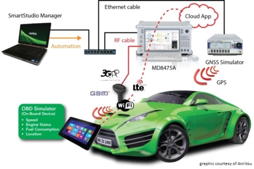
Anritsu plans to showcase a sophisticated, cloud-based connected car system for fleet tracking at Mobile World Congress 2015, which will be held in Barcelona March 2-5. The system was developed by the University of Hertfordshire in the UK with the help of network simulation technology from Anritsu.
The system will be demonstrated using a GNSS simulator from Spectracom to provide location information to the system being tested.
The connected car demonstration will show a car’s diagnostics system connecting to the cloud via a simulated LTE network environment provided by Anritsu’s mobile network simulator, the MD8475A. An application in the cloud enables a fleet manager on any Internet-connected device to view the location and operating parameters of any vehicle in the fleet in real time.
The MD8475A enables the university’s development team to test, from their Hertfordshire laboratory and with a single instrument, how the system’s in-car LTE modem would perform in mobile networks all across the world, and operating according to all major worldwide standards.
The combination of the MD8475A and the Spectracom simulator provides a complete test environment, to simulate any global location, and any type of cellular connectivity, to ensure correct operation of the system. This test bed will showcase the effectiveness of a complete wireless test-bed solution, to enable cost-effective development testing, product validation, and customer experience evaluation within a single system.
Anritsu Corporation has been a communications provider solutions for more than 110 years, with test and measurement solutions including wireless, optical, microwave/RF and digital instruments, operations support systems and solutions that can be used during R&D, manufacturing, installation and maintenance.
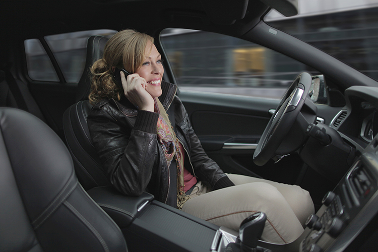
Volvo Cars has a complete system solution that makes it possible to integrate self-driving cars into real traffic, with ordinary people in the driver’s seat. The automaker presented its planned system in an online press conference Feb. 19.
“We are entering uncharted territory in the field of autonomous driving,” said Peter Mertens, senior vice president of Research and Development, Volvo Car Group. “Taking the exciting step to a public pilot, with the ambition to enable ordinary people to sit behind the wheel in normal traffic on public roads, has never been done before.”
As the Drive Me project enters its second year, Volvo is moving toward its goal of placing 100 self-driving cars in the hands of customers on selected roads around Gothenburg by 2017. The public pilot — a collaboration between legislators, transport authorities, a major city and a vehicle manufacturer — is a central component of Volvo’s plan to achieve sustainable mobility and ensure a crash-free future.
Early prototype cars are now being tested on the DriveMe route in and around Gothenburg, Sweden.
Volvo’s production-viable autonomous driving system is based on a complex network of sensors, cloud-based positioning systems and intelligent braking and steering technologies.
“Autonomous driving will fundamentally change the way we look at driving. In the future, you will be able to choose between autonomous and active driving,” Mertens said. “This transforms everyday commuting from lost time to quality time, opening up new opportunities for work and pleasure.”
Volvo’s autopilot system is designed to be reliable enough to allow the car to take over every aspect of driving in autonomous mode, Volvo said. The technology advances a crucial step beyond the automotive systems demonstrated so far since it includes fault-tolerant systems, the carmaker said.
“It is relatively easy to build and demonstrate a self-driving concept vehicle, but if you want to create an impact in the real world, you have to design and produce a complete system that will be safe, robust and affordable for ordinary customers,” said Erik Coelingh, technical specialist at Volvo Cars.
The main challenge is to design an autopilot that is robust for traffic scenarios as well as for technical faults that may occur. The driver can’t be expected to suddenly intervene in a critical situation. Initially, the cars will drive autonomously on selected roads with suitable conditions, such as without oncoming traffic, cyclists or pedestrians.
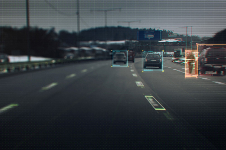
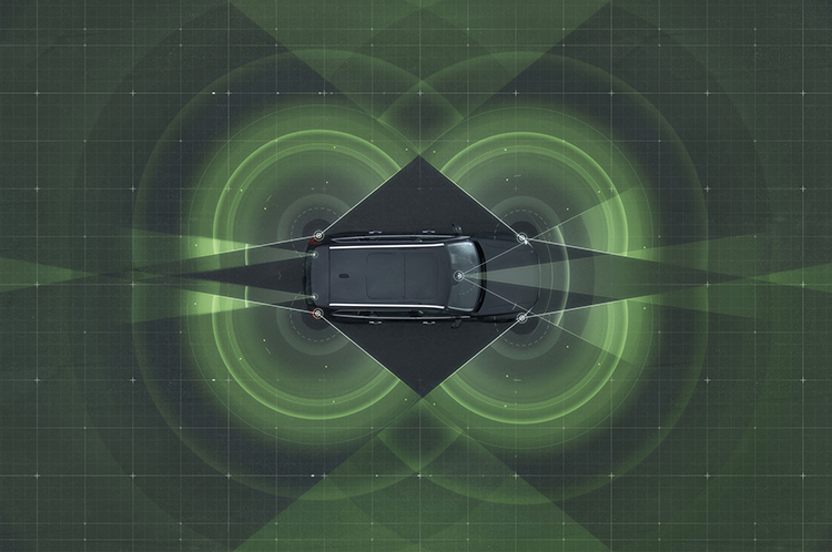
Volvo’s system generates exact positioning and a complete 360° view of the car’s surroundings through a combination of radars, cameras and laser sensors. A network of computers processes the information, generating a real-time map of moving and stationary objects in the environment.
“Making this complex system 99 percent reliable is not good enough. You need to get much closer to 100 percent before you can let self-driving cars mix with other road users in real-life traffic,” Coelingh said. “Here, we have a similar approach to that of the aircraft industry. Our fail-operational architecture includes backup systems that will ensure that the autopilot will continue to function safely if an element of the system were to become disabled.”
For example, the probability of a brake system failure is very small, but a self-driving vehicle needs a second independent system to brake the vehicle to a stop, because it is unlikely that the driver will be prepared to press the brake pedal.
On the road, the complete technology solution is designed to handle even the most complicated scenarios, from smooth commuting to heavy traffic and emergency situations, Volvo said. “Just as good drivers would, potentially critical situations are approached with sensible caution. In a real emergency, however, the car reacts faster than most humans,” Coelingh said.
When autonomous driving is no longer available — because of weather, technical malfunction or the end of the route has been reached — the driver is prompted by the system to take over again. If the driver is incapacitated for any reason and does not take over in time, the car will bring itself to a safe place to stop.
Volvo expects that autonomous driving could cut fuel consumption, improve traffic flow, and open up possibilities for urban planning and more cost-efficient investments in infrastructure.
“Developing a complete technological solution for self-driving cars is a major step. Once the public pilot is up and running, it will provide us with valuable knowledge about implementing self-driving cars in the traffic environment, and help us explore how they can contribute to sustainable mobility,” Coelingh said. “Our smart vehicles are a key part of the solution, but a broad societal approach is vital to offer sustainable personal mobility in the future. This unique cross-functional cooperation is the key to a successful implementation of self-driving vehicles.”
Drive Me system components:
The 76-GHz frequency-modulated, continuous wave radar is placed in the windscreen and combined with a camera to detect objects on the road. Four radars behind the front and rear bumpers locate objects in all directions. Long-range radars in the rear ensure a good rearward detection of vehicles in parallel lanes.
Sensor technologies. Volvo Cars is developing a holistic solution that generates exact positioning and a complete 360-degree view of the car’s surroundings. This is achieved by a combination of multiple radars, cameras and laser sensors. A redundant network of computers processes the information, generating a real-time map of moving and stationary objects in the environment.
Precise positioning is based on this surround information together with GPS and a high-definition 3D digital map that is continuously updated with real-time data. The system is reliable enough to work without requiring driver supervision.
Combined radar and camera. The combined 76-GHz frequency-modulated continuous wave radar and camera placed in the windscreen is the same as that in the new XC90. This system reads traffic signs and the road’s curvature and can detect objects on the road such as other road users.
Surround radars. Four radars behind the front and rear bumpers (one on each corner of the car) are able to locate objects in all directions. By sweeping both left and right, transmitting waves that bounce off signs, poles, and tunnels, they monitor a full 360-degree around the car.
360-degree surround vision. Four cameras monitor objects in close proximity to the vehicle. Two are under the outer rear-view mirrors, one is in the rear bumper and one is in the grille. Besides detecting objects at close range, these cameras monitor lane markings. The cameras have a high dynamic range and can handle quick changes in lightning conditions, such as when entering a tunnel.
Multiple beam laser scanner. This sensor system is placed in the front of the vehicle, below the air intake. The scanner can identify objects in front of the car and ensures very high angle resolution. It can also distinguish between objects. The laser sensor has a range of 150 meters for vehicles and covers a 140-degree field of view.
Trifocal camera. A trifocal camera placed behind the upper part of the windscreen is three cameras in one, providing a broad 140-degree view, a 45-degree view and a long-range, yet narrow, 34-degree view for improved depth perception and distant-object detection. The camera can spot suddenly appearing pedestrians and other unexpected road hazards.
Long-range radars. Two long-range radars placed in the rear bumper of the car ensure a good rearward field of view. This technology is useful when changing lanes because it can detect fast-moving vehicles approaching from far behind.
Ultrasonic sensors. Twelve ultrasonic sensors around the car are used to identify objects close to the vehicle and support autonomous driving at low speeds. The sensors are based on the technology used for current park-assist functions enhanced with advanced signal processing. This technology is useful for detecting unexpected situations, such as pedestrians or hazards on the road close to the car.
High-definition 3D digital map. A high-definition 3D digital map provide the vehicle with information about the surroundings, such as altitude, road curvature, number of lanes, geometry of tunnels, guard rails, signs, and exits. The position geometry is in many cases at centimeter level.
High-performance positioning. The high-performance GPS is one part of the positioning control that is enhanced by a combination of an advanced GPS, a three-degrees-of-freedom accelerometer and a three-degrees-of-freedom gyro. By matching the 360-degree image created by the multitude of sensors with the map image, the car will get the information about its position in relation to the surroundings.
By combining the information from the sensors and the map, the Drive Me car is able to choose the best course in real time, factoring in variables such as the curvature of the road, speed limit, temporary signs and other traffic.
Cloud services. The cloud service is connected to the traffic authorities’ control center. This ensures that the most up-to-date traffic information is always available. Control center operators also have the ability to tell the drivers to turn off the autonomous drive mode if necessary.
Driverless cars are now traveling Britain’s public roads, according to a report in the Providence Journal. Four prototype self-driving cars took to the country’s highways, launching Britain’s first public trials. Still, with regulatory and legal hurdles, officials said fully driverless cars are unlikely to be used on British roads until 2030.
Four types of autonomous vehicles are being tested, including a shuttle that looks like a larger golf cart and a compact two-seater “pod.” Journalists took rides on the shuttle, which traveled a public square outside central London’s O2 Arena.
The project was “still in the early days,” Transport Minister Claire Perry told the Associated Press, but she added the new technology has the potential to make roads safer and attract global investment.
Driverless cars are also being tested in U.S. cities by companies including Google, and Apple and Sony are at least exploring autonomous vehicles. Meanwhile, automakers such as Audi, Mercedes-Benz and Nissan are developing autonomous cars, and Volvo expects to test its self-driving cars on customers by 2017. The widely discussed goal is to have autonomous vehicles on the market by 202o.
Fleetmatics Group now offers new features for its mobile field service management solution Fleetmatics WORK. The enhancements help businesses to operate more efficiently and maximize their resources, the company said. Fleetmatics is a global provider of mobile workforce solutions for service-based businesses.
This latest release dramatically accelerates time to cash for SMB operators by embedding a payment link directly into the emailed invoice that is generated. With this new online payment powered by Stripe, Fleetmatics WORK closes the loop between job completion and payment. Jobs can now be invoiced from the field instantly via email and transactions can be processed securely in real time.
Fleetmatics WORK has added integrations with QuickBooks Online in the U.S. and MYOB AccountRight Live in Australia and New Zealand. Now, when jobs are completed, the invoices flow seamlessly from Fleetmatics WORK to the user’s accounting system and updated client information is sent between the systems to keep all data in sync, Fleetmatics said.
Business owners now have additional tools to manage fieldworkers. As service businesses grow, it becomes increasingly important for them to have manageable views of their field. New fieldworker tags in Fleetmatics WORK give dispatchers clear visibility to sort schedules and make assignments based on best fit.
“Our mission is to help customers achieve greater levels of productivity, service and efficiency,” said Jonathan Durkee, Vice President of Product Management for Fleetmatics. “With the new online payments, seamless accounting integrations and increased fieldworker visibility we’re enabling field service businesses to drive even stronger results.”
Free training and ongoing support is available to all users through Fleetmatics’ award-winning customer service, which provides education and best practices for transforming data into actionable business intelligence.
Apple is working on its own autonomous car, according to Reuters. An auto industry source told Reuters that the tech giant is gathering information and parts to make a prototype for the autonomous electric vehicle — the entire car, not just automotive software or components.
“They don’t appear to want a lot of help from carmakers,” said the unnamed source.
Apple is gathering advice on parts and production methods, focusing on electric and connected-car technologies, while studying the potential for automated driving, the source told Reuters.
“Fully automated driving is an evolution. Carmakers will slowly build the market for autonomous cars by first releasing connected and partially automated cars,” the source said. “Apple is interested in all the potential ways you can evolve the car; that includes autonomous driving.”
Meanwhile, Sony is also turning to autonomous vehicles, according to USA Today. The electronics giant is teaming up with Japanese robotics company ZMP to develop self-driving automobiles, reports the Financial Times. Sony invested 100 million yen (about $842,000) in ZMP.
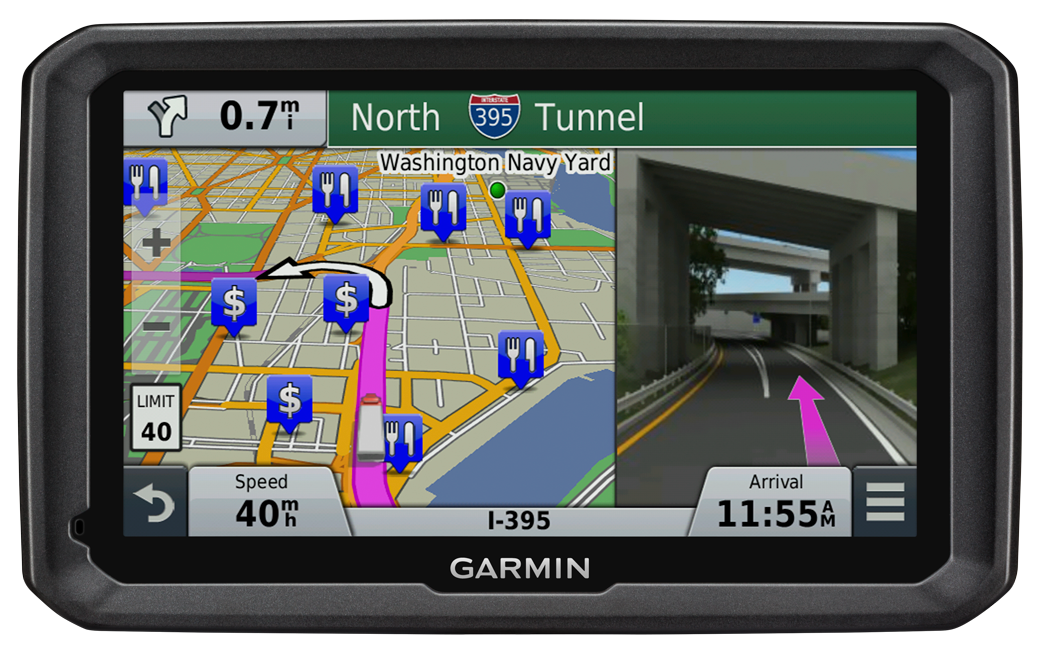
Lawyers for 11 Pennsylvania residents injured in 2013 when their charter bus slammed into an overpass in Boston, Mass., are suing GPS device manufacturers TomTom and Garmin, seeking more than $15 million in damages.
The bus driver was using both a Garmin and a TomTom satnav, neither of which were intended for use by commercial vehicles, but the lawsuit filed in January claims that the GPS units were at fault for not providing road height restrictions.
The bus driver, Samuel J. Jackson, told police he drove the 11-foot-high bus onto Soldiers Field Road, which is off-limits to vehicles more than 10 feet high, because he was “following the GPS.” At least one sign warning of this restriction was missing or damaged, and construction on the Harvard Street overpass obstructed other warning signs, the suit said.
Passengers were injured when the bus roof crushed backwards in the crash dropping the luggage rack and television onto the heads of the passengers, the Boston Globe reports.
Both TomTom and Garmin manufacture GPS units for professional drivers which feature information on bridge underpass height restrictions.
TextBuster, a device by Access 2 Communications that prevents drivers from accessing text, email and Internet functions while driving, allows GPS to function while driving.
It does not interfere with inbound and outbound calling. The firmware technology behind TextBuster sends a blocking signal to the user’s phone automatically, every time the user enters the vehicle.
TextBuster will not interfere with any other hands-free or Bluetooth items in the vehicle, according to the company. It is a patent-pending device that will disable the data functions to the driver’s phone only while inside the vehicle without interfering with inbound and outbound calls. It includes two components, the mobile app, which is a free download, and a small “brain box” that is mounted under the dash.
Ohio-based Access 2 Communications developed the distracted driving device with the hopes of significantly reducing the number of preventable distracted driving fatalities worldwide.
TextBuster will be available in Target stores nationwide starting in mid-November, according to TextBuster.
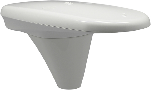
Hemisphere GNSS is offering the Vector V104, a tiny high-accuracy, dual-receiver GPS compass and the latest addition to its precise heading and positioning product line.
“Our Vector V104 provides an astonishing level of accuracy in such a small form factor,” said Chuck Joseph, Hemisphere president and CEO. “The smart, compact design offers better than 2° heading accuracy and sub-meter DGPS position accuracy without requiring maintenance or calibration and while being immune to magnetic interference.”
Based on the company’s patented Crescent Vector technology, the Vector V104 integrates two GPS antennas, a multi-axis gyro, and a tilt sensor into a single, easy-to-use system. The dual-integrated antennas provide both heading and position data, and the gyro and tilt sensor improve system performance and provide backup heading information if the GPS-based heading is ever lost.
The Crescent technology provides highly accurate code phase management and outstanding multipath mitigation. This results in excellent accuracy and stability, enabling the user to install the V104 in areas where competing products have difficulty.
“As the world’s smallest GPS compass, the V104 will significantly change the onboard experience in navigation, making it more accurate, easier to install, and more cost efficient,” said Anders Bergström, founder and senior partner of True Heading AB, who sells a custom-branded V104 as the Vector Compact into the marine market.
An alternative to traditional gyro and fluxgate compass sensors, the Vector V104 offers a choice of either serial or NMEA2000 communications and is designed for a wide array of applications, especially in the marine, GIS mapping, and machine control markets.
The Federal Aviation Administration (FAA) declared today that Super Bowl XLIX will be a “No Drone Zone.”
“Many familiar sounds are associated with the Super Bowl: Cheering fans. Referee whistles. The spectacular halftime show. Booming fireworks,” the FAA wrote. “But one sound you shouldn’t hear is the whirring of an unmanned aircraft overhead. The Super Bowl is strictly a ‘No Drone Zone’.” The restriction applies to University of Phoenix Stadium in Glendale, Arizona, during the game.
The FAA bars unauthorized aircraft — including drones — from flying over or near NFL regular- and post-season football games. The same restriction applies to NCAA college games in stadiums seating 30,000 or more fans, Major League Baseball games and many NASCAR events. Other unauthorized aircraft include airplanes, hang gliders, hot air balloons, and model rockets.
The FAA Notice to Airmen makes it crystal clear that anyone violating the rules may be “intercepted, detained and interviewed” by law enforcement or security personnel. Besides possibly landing a violator in jail, flying an unmanned aircraft over a crowded stadium could result in an FAA civil penalty for “careless and reckless” operation of an aircraft.
The agency also produced a YouTube video with the same message.
Telematics Detroit, the connected car event, has officially changed its name to TU-Automotive Detroit to reflect the paradigm shift in auto mobility. The event will take place June 3-4 at The Suburban Collection Showplace in Detroit.
The name change to TU-Automotive Detroit is intended to reflect how “automakers are evolving from heavy manufacturers into nimble technology companies and the self-driving car is moving from the realms of science fiction onto the reality of our highways. The car as we know it is rapidly changing,” organizers said in a statement.
Experts will provide overviews in three core areas of telematics, mobility and autonomous cars.
“Anticipating the future trends of the automotive industry is exactly what this conference has always been about,” said Justin Parker, project director. “Accordingly, the new angle of the show addresses the headline topics of mobility and autonomous vehicles.”
Key topics:
Telematics – the here and now: Consider the building blocks of the connected car that continue to present challenges and opportunities such as the ultimate user experience, the connected society and the aftermarket. It is these foundations that are paving the way for the future of auto-mobility.
Auto-mobility: The role of the car is changing. From new ownership models to sustainable transportation and smart cities, get to grips with the technology and societal changes that are fundamentally reshaping mobility.
The autonomous car: Sensors, lasers, ADAS and regulators. The end-goal of the self-driving car is an exciting amalgamation of regulatory and technological developments. We’re deep into the journey of the autonomous car and now is the time for the industry to come together to collectively take the next step.
Get the latest updates and information and register for the brochure with full speaker line-up and agenda.
By 2020 a quarter billion connected vehicles will be on the road, enabling new in-vehicle services and automated driving capabilities, according to Gartner, Inc. During the next five years, the proportion of new vehicles equipped with this capability will increase dramatically, making connected cars a major element of the Internet of Things (IoT).
Gartner forecasts that 4.9 billion connected things will be in use in 2015, up 30 percent from 2014, and will reach 25 billion by 2020.
“The connected car is already a reality, and in-vehicle wireless connectivity is rapidly expanding from luxury models and premium brands to high-volume midmarket models,” said James F. Hines, research director at Gartner. “The increased consumption and creation of digital content within the vehicle will drive the need for more sophisticated infotainment systems, creating opportunities for application processors, graphics accelerators, displays and human-machine interface technologies. At the same time, new concepts of mobility and vehicle usage will lead to new business models and expansion of alternatives to car ownership, especially in urban environments.”
Gartner forecasts that about one in five vehicles on the road worldwide will have some form of wireless network connection by 2020, amounting to more than 250 million connected vehicles. The proliferation of vehicle connectivity will have implications across the major functional areas of telematics, automated driving, infotainment and mobility services.
LoJack Corporation is collaborating with Novatel Wireless to develop robust positioning and accuracy capabilities in the LoJackConnect for Inventory Management system. The system helps sales personnel at dealerships accurately track and actively monitor vehicle inventory across multiple lots, helping to minimize the time required in the regular dealer inventory process. Accessible via computer, tablet and mobile phone, users can verify vehicle location, access relevant vehicle information, track test drives and receive early warning alerts if a vehicle is moved from a geofenced location.
LoJack Connect for Inventory Management is powered by the Novatel Wireless 3060 OBDII solution for HSDPA/GSM/GPRS. The MT 3060 is a specialized OBD II telematics solution that offers advanced technology and a sophisticated feature set, combined with high quality and compatibility testing standards, Novatel Wireless said. With dual accelerometers, GNSS support, an open platform, and the N4A Content Cloud Management System, the MT 3060 enables LoJack to offer a reliable telematics solution to dealerships nationwide.

 TextBuster, a device by Access 2 Communications that prevents drivers from accessing text, email and Internet functions while driving, allows GPS to function while driving.