Navman Wireless is launching an integrated vehicle tracking and camera technology product aimed at helping businesses manage risk, improve road safety, and reduce insurance costs. The product, labeled “360 Degree,” integrates telematics, vehicle tracking technology and in-cab safety camera equipment to create what Navman calls a “seamless umbrella of preventive and protective technology.”
The system is designed to help mitigate poor driving, reducing on-the-road risk. “Prevention is better than cure, and using data from telematics and vehicle tracking software to help mitigate poor driving significantly reduces on-road risk, but when you are on the road you need 360 degrees of protection,” said Hutchins.
Navman Wireless describes the in-cab safety camera equipment, supplied by Smart Witness, as a safety net. “It’s a last line of defense for drivers and fleet businesses in those unfortunate circumstances beyond their control,”said Scott Hutchins, VP sales UK and Ireland, Navman Wireless. “The introduction of in-cab camera technology not only protects the driver and business from not-at-fault claims, but also enables us to offer a complete proactive and preventative solution that has the potential to deliver measurable improvements in terms of accident and cost reduction.”
“It’s about prevention and protection. Telematics technology is integral to a successful preventive safety strategy because it can be effectively utilized to assess drivers and ensure safety and quality,” Hutchins said.
Russia’s S7 Airlines has received approval for three Boeing 737-800s to perform landings using GNSS, becoming the country’s first carrier to do so, reports Air Transport World.
According to an S7 statement, more than 50 airports in Russia have installed equipment allowing global positioning landings (GLS). Russia’s State Air Transport Management Corp. plans to certify 10-15 airports per year for GLS landing.
“GLS will allow the airline to improve flights’ regularity, which is one of our priorities,” Globus Airline CEO Vadim Klebanov said. Globus Airline is a member of the S7 Group.
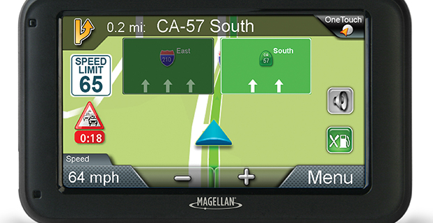
Magellan has introduced its newest lineup of 5-inch RoadMate auto navigators at the International Consumer Electronics Show, being held this week in Las Vegas. To provide a more realistic view of a user’s surroundings, each of the GPS models comes equipped with 3D renderings of buildings and landmarks.
The new models are: RoadMate 5322-LM, RoadMate 5330T-LM with real-time traffic alerts, and RoadMate 5375T-LMB with real-time traffic alerts, Bluetooth connectivity and portrait viewing mode.
The units will be displayed at CES in the Magellan booth, LVCC South Hall 2, MP25441.
“Our new RoadMate 5-inch GPS devices for 2015 have large, vibrant displays and include a vast collection of renowned Magellan navigation features,” said Stig Pedersen, Magellan associate vice president of product management. “Plus, each model includes 3D renderings of buildings and landmarks to make it easier and quicker for users to identify where they are. Whether driving to work, across country, or going to grandma’s, drivers can count on these Magellan navigation units to safely guide them to wherever their destination is.”
Below are a few of the features that the three RoadMate GPS devices share.
3D Renderings – Selected buildings and landmarks are presented in 3D for a more realistic view.
Lifetime Map Updates – Owners of these three models can download the latest map information (up to four times a year) for all 50 states and Canada.
Traffic Camera Alerts – Sends audible and visual warnings of upcoming red lights, speed cameras, and more; provided by PhantomALERT.
7,000 POIs – Includes branded and highway exit POIs to conveniently search for restaurants, hotels, gas stations, and more.
OneTouch Favorites Menu – Creates shortcuts to favorite destinations and searches.
Multi-Destination Routing – Users can plan their entire day or multi-day trip in one route.
Junction View – Realistic images of freeway signs and arrows guide drivers to the correct lane.
SmartDetour – Provides immediate options when traffic suddenly comes to a halt.
RoadMate 5330T-LM
In addition to the features above, the 5330T-LM also includes:
Free Lifetime Traffic Alerts – Helps users avoid traffic jams and delays, suggests detours, provides travel times; no hidden fees or subscriptions.
RoadMate 5375T-LMB
In addition to the features above, the 5375T-LMB also includes:
Free Lifetime Traffic Alerts – Helps users avoid traffic jams and delays, suggests detours, provides travel times; no hidden fees or subscriptions.
Portrait Viewing Option – Provides extended view of the road ahead.
Bluetooth Compatibility – Turns this RoadMate model into a hands-free speakerphone, making drive time safer and more productive.
The Magellan 5-inch RoadMate family of auto navigation devices will be available at retailers throughout the U.S. and Canada as well as online in March 2015. MSRPs are as follows: $149.99 (RM5322-LM); $159.99 (RM5330T-LM); and $199.99 (RM5375T-LMB).
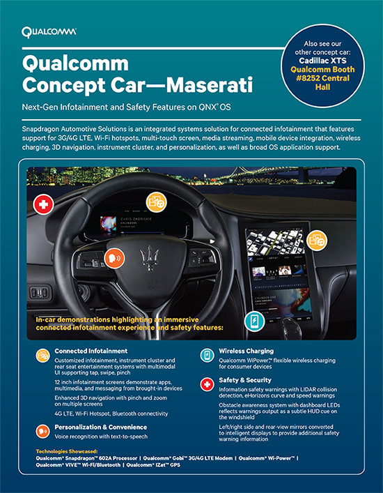
Qualcomm Technologies will demonstrate two new full technology concept cars that integrate Qualcomm Technologies’ latest in vehicle technology and connectivity at the 2015 Consumer Electronics Show, being held this week in Las Vegas. The technology concept cars are based on the 2015 Maserati Quattroporte GTS and the 2015 Cadillac XTS and have been customized to bring the full Snapdragon Automotive Solutions experience to life, including the Qualcomm Snapdragon 602A automotive-grade processor, Qualcomm Gobi 3G/4G LTE wireless modems and Qualcomm VIVE QCA6574 Wi-Fi and Bluetooth module, and Qualcomm IZat RGR7640 GNSS module. Qualcomm Snapdragon and Qualcomm Gobi are products of QTI, and Qualcomm VIVE and Qualcomm IZat are products of QCA.
The Qualcomm Concept Car – Cadillac demonstrates pre-integrated support for Android, including the latest Android L and Kit Kat; high resolution infotainment displays for visually stunning graphics for cluster and infotainment; integrated in-vehicle features, including navigation, music, live streaming of sports, news and entertainment content via LTE-Broadcast; enhanced safety features such as lane detection with integrated navigation, driver distraction avoidance notification, gesture recognition, car personalization via the AllSeen Alliance’s AllJoyn open source framework; wireless audio streaming from personal devices via the Qualcomm AllPlaysmart media platform; smartphone integration and Qualcomm WiPower flexible wireless charging for consumer electronics and; 4G LTE multimode Internet connectivity including WiFi hotspot and Bluetooth profile support.
The Qualcomm Concept Car – Maserati features pre-integrated support for the latest versions of the QNX Neutrino OS and the QNX CAR Platform for Infotainment from QNX Software Systems, a subsidiary of BlackBerry Limited. Highlights include an instrument cluster with speed recommendations, collision warnings, and intelligent parking assist; an infotainment system with 3D navigation, smart phone integration, rear seat entertainment with easy-to-use multimodal UI supporting gestures (tap, swipe, pinch), and voice recognition; an immersive driver experience with rear and side view mirror/displays, complete with refitted cameras and informational safety features; WiPower flexible wireless charging for consumer electronics; and 4G LTE multimode Internet connectivity, including WiFi hotspot and Bluetooth profile support.
Integrated into the technology concept cars are:
Elektrobit’s EB street director navigation software and the latest version of its EB Assist eHorizon Solution with audible and visual warnings and recommendations about the road ahead
TomTom advanced navigation and map services
Jungo’s MediaCore smartphone connectivity and multimedia playback
Rightware’s software and user interface for the instrument cluster
Ricardo’s integrated hardware, controls and electronics
Streaming Internet radio services from Pandora via HTML5 and iHeartRadio via Android
Voice recognition and speech-to-text services powered by Nuance’s Dragon Drive
NXP’s SAF775x AM/FM radio tuner support
QNX Neutrino OS and QNX CAR Platform for next-generation safety and infotainment features
The concept cars are on display at CES, located at the Las Vegas Convention Center, Central Hall, Booth 8252 and Central Plaza, Booth CP21A.
Nexcom introduces in-vehicle computers VTC 7230 and VTC 7240 to foster the growth of connected vehicles in the IoT (Internet of Things), which aims to offer safer and more efficient driving experience. Featuring fifth-generation Intel Core processors, the in-vehicle computers have numerous telematics features to support fleet management, security features to protect vehicles in the IoT, and performance to drive ADAS (Advanced Driver Assistance Systems) and stream multiple video surveillance feeds.
For fleet management, VTC 7230 and VTC 7240 feature built-in GPS for vehicle tracking and navigation, and a CAN bus 2.0B interface with optional OBD II function for vehicle diagnostics. To enable remote monitoring of vehicle diagnostics, store and exchange data of video surveillance feeds and IVI (In-Vehicle Infotainment) services, VTC 7230 and VTC 7240 feature four mini-PCIe expansions with dual WWAN support and dual external HDDs, providing high cellular bandwidth for fast connections and ample storage for large video and media files.
“The pursuit of driving safety and efficiency has been the driving force for advancements in in-vehicle technologies,” said Steven Wu, general manager of Nexcom’s Vertical Industry Platform (VIP) Business Unit. “Using fifth-generation Intel Core processors i3-5010U and i7-5650U respectively, VTC 7230 and VTC 7240 provide signal processing, machine vision, and video transcoding capabilities required of ADAS, ANPR (Automatic Number Plate Recognition) and video surveillance, giving abilities to sense and to think to fleet transport, public transport, police vehicles, ambulances and more.”
“The fifth-generation Intel Core processors utilizing Intel’s new 14nm process has integrated Intel HD graphics 5500 and 6000 and expanded hardware security. Its excellent performance adds multitasking capability for compute-intensive applications such as Advanced Driver Assistance Systems (ADAS), while the Intel Quick Sync Video provides fast transcode time. Furthermore, hardware security design, Intel OS Guard and Intel AES-NI, helps protect systems against malware intrusions and helps accelerate data encryption.” said Samuel Cravatta, IOTG product line director, Intel.
For added physical security, the pre-alarm function on the in-vehicle computers features two DI and DO channels and an event button signal that can both operate in power-off state, ensuring alarms and emergency notifications are constantly available at times of intrusion or urgent conditions.
For fleet management, VTC 7230 and VTC 7240 feature built-in GPS for vehicle tracking and navigation, a CAN bus 2.0B interface with optional OBD II function for vehicle diagnostics. Furthermore, to enable remote monitoring of vehicle diagnostics, store and exchange data of video surveillance feeds and IVI (In-Vehicle Infotainment) services, VTC 7230 and VTC 7240 feature four mini-PCIe expansions with dual WWAN support and dual external HDDs, providing high cellular bandwidth for fast connections and ample storage for large video and media files.
By Ugo Celestino, European Commission, Antonella Di Fazio, Telespazio SpA, Vicente José Giner Herrera, Ineco, Patrizio Vanni, ENAV SpA, and Francisco Javier Deblas, ESSP.
This article describes a live demonstration of an aviation application in Tunisia, to help the local aviation community in validating the use of the European Geostationary Navigation Overlay Service (EGNOS) to guide airplanes during landing operations. This activity constitutes the first complete experience of EGNOS Safety of Life (SoL) service for aviation approaches outside Europe. We present here the obtained results that are useful not only for Tunisia, but as a valuable case study for other countries outside Europe interested in using EGNOS in aviation.
EGNOS, operational since 2009, has a European regional coverage that could be quite easily extended to areas adjacent to European Union through the deployment of limited additional ground infrastructure elements, but sharing the same existing space segment and leveraging the other core ground infrastructure.
The European Commission has put in place a series of actions since 2006 to support the EGNOS service extension in neighbouring areas. The MEDiterranean follow-Up for EGNOS Adoption (MEDUSA) is an on-going European initiative related to EGNOS extension in the Euromed region, including North African and Middle East countries around the Mediterranean basin: Algeria, Egypt, Israel, Jordan, Lebanon, Libya, Morocco, Palestine, Syria, and Tunisia. MEDUSA runs a program of technical assistance action in these Euromed countries, in order to prepare them for an optimal adoption and exploitation of European GNSS services in their priority market segments.
The Mediterranean Extension of EGNOS
EGNOS is Europe’s first venture into satellite navigation and paves the way for Galileo, Europe’s independent global satellite navigation system currently under deployment.
EGNOS is a satellite-based augmentation system (SBAS), whose signal is compliant to the international SBAS interoperability standards: standards – MOPS (Minimum Operational Performance Standards) and ICAO SARPs (International Civil Aviation Organization Standard and Recommended Practices). In its current version (V2) it augments the open public service offered by the American Global Positioning System (GPS), by providing correction data that enables to improve GPS position accuracy, and provides integrity information about the GPS system (integrity information is fundamental for aeronautical applications like approaches). EGNOS is interoperable with the other equivalent regional systems. Today other SBASs are the U.S Wide Area Augmentation System (WAAS), the Japanese Multi-functional Satellite Augmentation System (MSAS), the Indian GPS Aided Geo Augmented Navigation (GAGAN) and the Russian System for Differential Correction and Monitoring (SDCM). The future version (V3) of EGNOS will augment Galileo signal as well.
Today EGNOS is operational, and available for use in aviation since 2011, giving opportunities for users to have more accurate and reliable positioning for enhancing existing applications, developing new applications and particularly the safety critical ones. Already more than 150 landing procedures are operational across Europe (some of them also in countries out of the European Union, such as Switzerland, Norway, Guernsey), with many others under development to reach 100 percent Approaches with Vertical Guidance (APV) coverage in the European instrumental runways as per ICAO recommendation.
EGNOS provides three services:
EGNOS Open Service (OS), launched in 2009, is delivered free of charge. It is open for use to anyone with an EGNOS-enabled receiver. This can be any receiver compatible with satellite-based augmentation systems. Being based on GPS, the EGNOS signal does not require major changes for receivers. Today, many mass market receivers available on the market are also EGNOS enabled. EGNOS OS is particularly suitable for mass market and some applications like surveying.
EGNOS Safety-of-life Service (SoL) is authorized for European civil aviation and operational since March 2011. EGNOS SoL delivers the integrity message providing the verification of the GPS system and timely warnings (within six seconds), when the system or its data should not be used for navigation. Since integrity relates to the trust that can be placed in the correctness of the location information supplied by GPS, thanks to this feature EGNOS is able to meet the demands of safety-critical applications in sectors such as aviation.
EGNOS Data Access Service (EDAS) launched in 2012, delivers a terrestrial commercial data service. It consists of a server that gets the data directly from EGNOS system and disseminates it via terrestrial networks in real time, within guaranteed maximum delay, security and performance. EDAS is particularly suitable for professional applications. It provides EGNOS raw data and corrections enabling software solutions that implement products and value added services built on them.
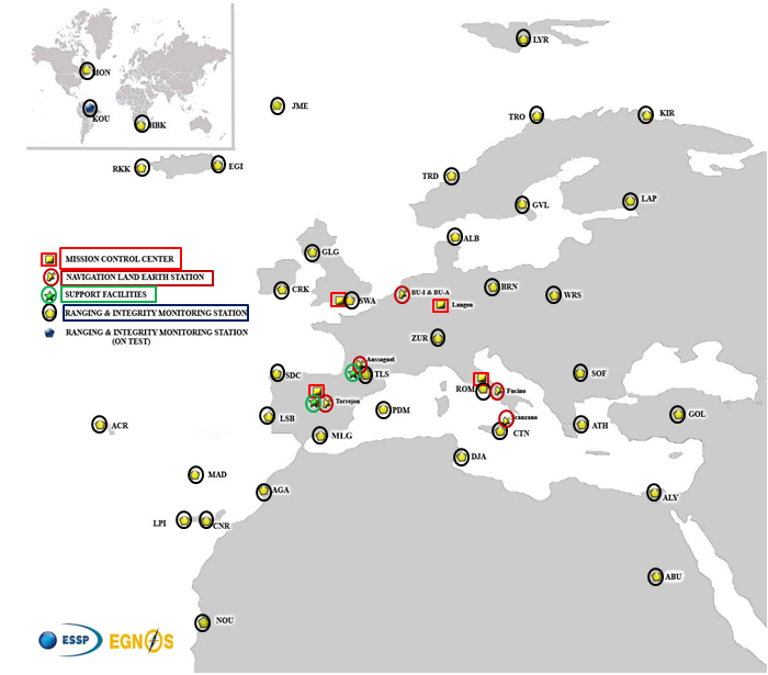
EGNOS infrastructure consists of three geostationary satellites over Europe and a network of ground stations (Ranging and Integrity Monitoring Station – RIMS) located to provide services whose coverage includes southern Europe, North Africa and some Middle East countries.
The EGNOS RIMS network supports a flexible network geometry that gradually adapts to service coverage requirements evolution. From the originally envisaged coverage over European Union’s countries, the EGNOS RIMS network is being expanded over Europe’s neighbouring areas, thus increasing the number of beneficiary countries. EGNOS SoL service is highly sought by several non-EU countries for the benefits it can bring to their civil aviation, in providing a solution to comply with ICAO requirements for Performance Based Navigation (PBN).
The present layout of the EGNOS RIMS network is presented in Figure 1.
Figure 1. EGNOS ground segment.
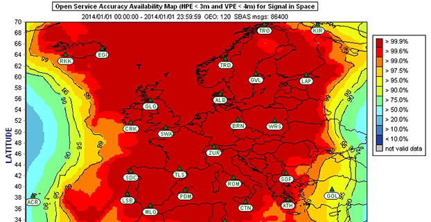
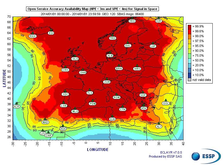
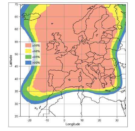
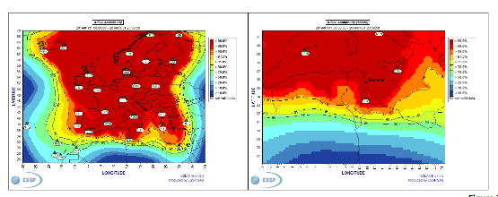
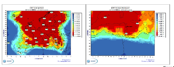
Figures 2 and 3 show respectively today’s coverage of EGNOS OS availability (source: European Satellite Services Provider, the service provider of EGNOS) and the APV-I availability performance commitment provided by EGNOS SoL (source: EGNOS Safety of Life Service Definition Document, EGN-SDD SoL, V2.0, European Commission, 2013), obtained relying on the above presented ground segment.
Figure 2. EGNOS OS Availability.
EGNOS OS Availability. The Figure 2 map is obtained by projecting the error at pseudorange level into the position domain. The computed error assumes that the GPS satellites used are those with an elevation angle above the local horizon (with a mask angle of 5º) and does not consider any possible factor depending on local characteristics that could produce different results (optimistic or pessimistic) with respect to the results computed using real receivers located in the considered areas. Moreover, it represents an estimation of EGNOS OS availability during a very limited period of time being an estimation, thus it does not imply any commitment or reference for the performances which can be obtained during different periods.
Figure 3. EGNOS APV-I Availability.
Other initiatives for a further extension in North Africa and Middle East are already being developed, under the umbrella of the Euromed GNSS programme. In parallel with the infrastructure deployment, the Euromed GNSS programme also includes actions to support the introduction and exploitation of EGNOS services. The first stage was completed in the frame of the Euromed GNSS I/MEdiTerranean Introduction of GNSS Services (METIS) project in the period 2006-2009, the second stage is presently running in the frame of the Euromed GNSS II/MEDUSA project. Further initiatives are being planned for 2015 and beyond.
EGNOS Use in Aviation
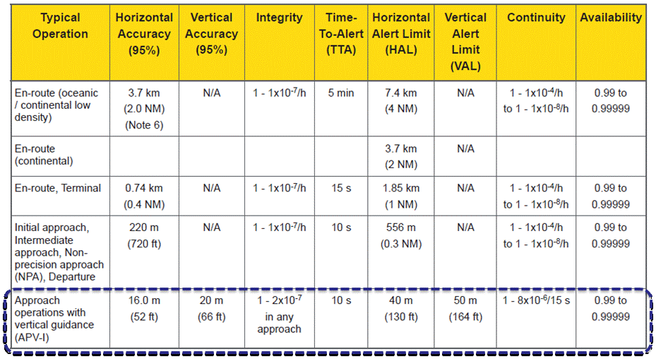
EGNOS was initially designed and developed to be used in aviation, similarly to the U.S. Federal Aviation Administration WAAS, to support different types of aviation applications and, in particular, to meet the performance requirements set by the International Civil Aviation Organization (Annex 10) for the implementation of APV-I, which enable the implementation of LPV final approaches, as reported in Table 1.
Table 1. ICAO Operational Requirements.
EGNOS is one of the GNSS elements recognised by ICAO (Annex 10) as a radionavigation aid. It is an important element of a global SBAS systems mosaic, that started with the American system WAAS in 2003, and that is gradually completed by other more recent SBAS: EGNOS itself, MSAS (Japan), GAGAN (India), SDCM (Russia), and some countries like Australia and South Korea that have launched feasibility studies to develop their own SBAS.
It is expected that, in a not too far future, most parts of the world will profit from SBAS services, following the current coverage extension plans and SBAS system evolutions. The final objective, as also shared at ICAO level, is that as many airdromes worldwide, as possible, can offer instrument approaches with vertical guidance, with an outstanding increase in global safety rates.
Additionally, the use of EGNOS allows taking full advantage of GNSS for all phases of flight, including final approach. Therefore, EGNOS means for aviation a fundamental and strategic tool to help meet ICAO’s recommendations, aimed at the adoption of a PBN oriented airspace use policy, for all countries. The 37th Assembly of ICAO (28 September – 8 October 2010) resolved that APV procedures should be implemented as either a primary or backup strategy for precision approaches at all instrument runway ends by 2016.
APV is a major safety initiative. ICAO recognises SBAS and Barometric Vertical Navigation (Baro-VNAV) as the two acceptable (and often complementary) means of implementing APV procedures, which are safer than NPA (Non Precision Approach).
GNSS based navigation enables RNAV (aRea NAVigation) with a higher cost effectiveness in comparison with the old conventional, sensor ground-based, navigation procedures. This is especially true for wide, even desert unequipped areas (or difficult to maintain) like those in North Africa and Middle East.
EGNOS benefits are maximized in final approach manoeuvres, providing GNSS lateral and vertical guidance, and enabling APV-I approaches.
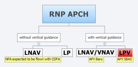
Final approach procedures based on GNSS are classified as RNP approaches (RNP APCH, as shown in the next figure), namely: Lateral Navigation (LNAV) with GPS lateral guidance and no vertical guidance; LP with GPS + SBAS (EGNOS) for lateral guidance (CAT-I localizer performance) and no vertical guidance; Lateral Navigation/Vertical Navigation (LNAV/VNAV) with GPS lateral guidance and Baro-Vertical Navigation (VNAV) vertical guidance (Baro-VNAV approach procedures can be flown with SBAS vertical guidance upon the approval of the Air Navigation Service Provider (ANSP)) and the LPV (Localizer Performance with Vertical Guidance) with GPS + EGNOS for both lateral and vertical guidance.
Figure 4. RNP approaches.
Those procedures not including vertical guidance are intended to be flown with the Constant Descent Final Approach (CDFA) technique (to avoid dangerous dive and drive practices), supported by most Flight Management Systems (FMS).
Regarding the operational LPV main figures, the European regulation (EU OPS -REGULATION (EC) No 859/2008 usually known as EU OPS) allows LPV operational minima (Decision Height – DH) down to 250 ft, expected to be possibly lowered down to 200 ft by 2015 (LPV-200), similarly to what is already permitted by the FAA, in the United Sates for WAAS based LPV approaches (a DH of 200 ft would make LPV approaches very competitive, when benchmarked against ILS CAT-I, precision approach, or even Ground Based Augmentation System (GBAS) CAT-I precision approach).
In the last few years, about 150 LPV procedures (status as of July 2014) have been published in European airports, and the number of procedures and countries introducing EGNOS is continuously increasing.
Euromed GNSS I/METIS and Euromed GNSS II/MEDUSA
In parallel with the development of the infrastructures necessary for extending EGNOS availability across the Euromed region, the European Commission has put in place initiatives to prepare and assist the Euromed countries for the optimal use and adoption of the relevant services.
These consist in two sequential projects, the first being Euromed GNSS I/METIS project and the second being Euromed GNSS II /MEDUSA.
Running from mid 2006 up to the end of 2009, METIS acted as a pioneer in the Euromed countries and built national/regional liaisons with decision-makers and key stakeholders, interested in sharing experience and absorbing know-how. The project assisted the 10 Euromed countries to identify their priorities in relation to the use of EGNOS services, to validate the relevant opportunities from the strategic/social and economic perspectives, and to elaborate a suitable strategy and a plan of actions for facilitating EGNOS adoption and exploitation.
MEDUSA Case Study in Tunisia: LPV Approaches in the Airport of Monastir Using EGNOS
As part of the technical assistance actions programme in the priority domains, MEDUSA implements demonstrations and validations of EGNOS services in concrete applications.
For EGNOS SoL, the technical assistance action consisted in the validation of GNSS approaches, including LPV approaches, designed and constructed in MEDUSA along with the relevant safety assessment and business case for the airport of Monastir in Tunisia (35°45’29’’ N 10°45’17’’ E). The selection of the airport was driven by a trade off between the EGNOS service availability with required APV-I performances and the specific needs of the Tunisian Air Navigation Service Provider – ANSP (OACA, Office de l’Aviation Civile et des Aéroports). According to OACA, Monastir is among the airports in Tunisia presenting favourable conditions, in terms of operational constraints and traffic, for concretely proving the added value of EGNOS for final approaches.
The airport has two runways, RWY 07 and RWY 25, the former is equipped with an ILS CAT-I, the latter only supports NPA approaches. The installation of an ILS in RWY 25 was discarded due to technical constraints. This infrastructure has proven to be insufficient to fully cover the airport needs, that suffers some Delays-Diversions-Cancellations (DDCs) as a result of local specific meteorological conditions, frequent fog banks entering from the sea in the early morning, combined with desert haze. These conditions make LPV ideal procedures, as backups to RWY 07, and enabling APV approaches to RWY 25. Finally, Monastir’s TWR ATC (Tower Air Traffic Control ) staff has been involved in OACA’s PBN development, for which they were ideal candidates to evaluate the benefits possibly achievable from the use of EGNOS.
This MEDUSA’s technical assistance action is the first complete experience for the use of EGNOS SoL service outside Europe. It was conceived as a realistic exercise of RNP APCH procedures implementation, following the guidelines provided by ICAO in the “EUR RNP APCH Guidance Material (EUR Doc 025)” and including all the activities required, from the scenario adequacy study to flight validation and the requirements analysis for the final publication in the AIP (Aeronautical Information Publication). OACA was directly involved in all activities, providing inputs/feedbacks and for training purposes.
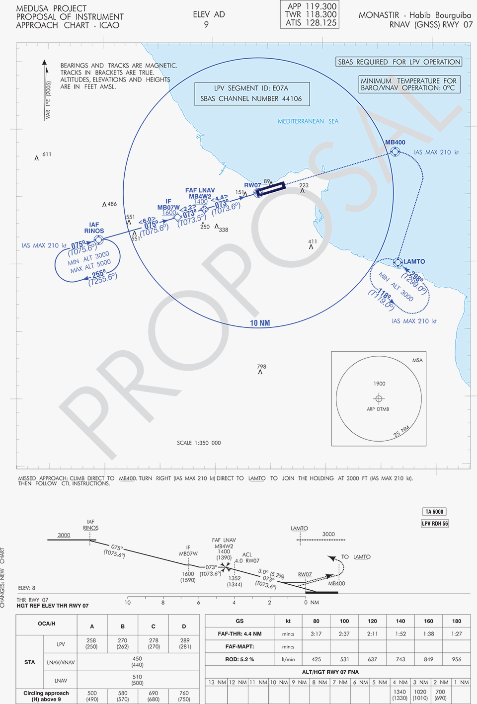
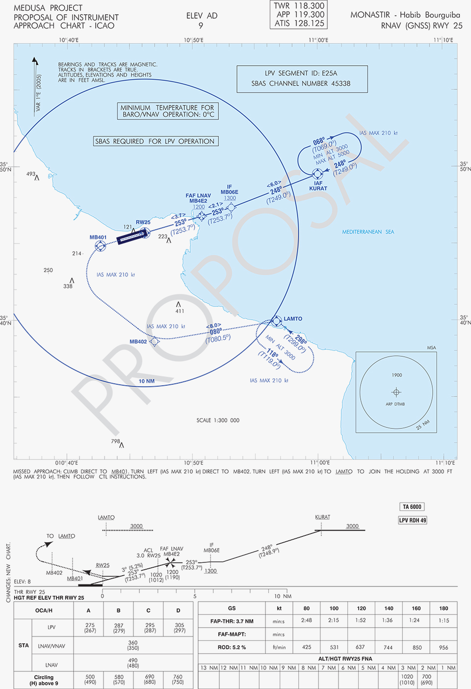
A set of three GNSS based approach procedures was produced for each RWY, following ICAO 8168 PANS OPS design principles. The next figures show the combined charts type elaborated, that include minima boxes for three RNP approaches (LNAV, LNAV/VNAV and LPV). The procedures construction preserves the current Monastir arrivals structure, following airspace management principles and facilitating the operational approval. As illustrated in the charts, in both cases for the three minima the calculated OCH (Obstacle Clearance Height) values improve with respect to the already existing conventional approaches, providing significant operational and safety benefits.
Figure 5. GNSS approaches for RWY 07.Figure 6. GNSS approaches for RWY 25.
An on-site GNSS performance monitoring campaign was performed by OACA, with the support of GEMCO’s staff, 3 months before the flight trials schedule, covering both EGNOS and GPS signal performances. Besides, an APV-I availability study for the area and specifically for Monastir airport during 1 month before the flight validation was purposely elaborated by the European EGNOS service provider (ESSP). Both analyses, confirmed suitable APV-I performance in terms of availability and continuity, making feasible the implementation of LPV approach procedures in line with ICAO prescriptions.
The next figures show the EGNOS APV-I availability and continuitymeasured on one day during the period of the flight validation (conducted from 30 January to 1 February 2014), in particular at Monastir airport for the considered time-lag:
APV-I availability was over 99%;
APV-I continuity presented a total value lower than 5×10⁻⁴/15s;
95th percentile of Horizontal APV-I accuracy was between 1.1 and 1.2 meters and the 95th percentile of Vertical APV-I Accuracy is around 1.4 meters, thus showing a very good accuracy level;
Horizontal and Vertical safety indexes were lower than 0.25, representing a very good integrity margin.
Additionally, the results of the on-site GNSS performance monitoring campaign showed quite stable performances with small fluctuations during the whole period of observation, and no problems or outages were observed.
(EGNOS APV-I Availability is defined as the percentage of epochs in a month in which the Protection Level are below Alert Limits for this APV-I service (HPL<40m and VPL<50m) over the total period (source: ESSP).
EGNOS APV-I Continuity Risk is defined as the result of dividing the total number of single continuity breaks using a time-sliding window of 15 seconds by the number of samples with valid and available PA navigation solution. A single continuity break occurs if the system is available at one epoch and becomes not available for the following 15 seconds (source: ESSP).)
Figure 7. APV-I availability on 31.01.2014.Figure 8. APV-I continuity on 31.01.2014.
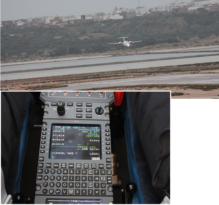
The flight validation campaign was carried out according to ICAO doc 9906 with a Piaggio P180 Avanti II (from ENAV flight inspection department) suitably equipped with UNIFIS 3000 system and a Rockwell Collins FMS 3000 with SBAS LPV approach capabilities.
Figure 9. Piaggio P180 Avanti II aircraft and the FMS messages during the flight validation.
The outcomes of this concrete experience have allowed the Tunisian authorities to identify the main elements for the publication of the validated procedures in their national AIP. They have also contributed to the analysis of the necessary process for the operational adoption of GNSS, including EGNOS, in aviation in countries beyond the EU boundaries.
The activities performed on performance assessment have been preparatory for discussions on GNSS monitoring and data recording on going at ICAO Navigation System Panel level, that would produce ICAO guidelines for States.
Therefore, this Tunisia’s “case study” represents a practical and realistic example that could be beneficial for the other non-EU countries in terms of best practice and lesson learnt. Moreover, methodology and guidelines have been derived to be possibly injected to other non-European countries interested to introduce EGNOS operations in aviation.
Lessons Learned and Outlook
Through its achievements, MEDUSA is opening the way for the introduction of EGNOS SoL service in North Africa and Middle-East region, and it is also defining a suitable path to be followed by other interested non-European countries. Overall, MEDUSA is continuing to confirm the ability to foster cooperation and involvement in EGNOS programme of the great majority of the Euromed countries. Further to Tunisia, other Euromed countries have already expressed their interest in relation to the EGNOS use in aviation, considering each country’s strategy and also in the light of a common shared regional perspective. Besides, the results obtained by MEDUSA are useful also for other regions interested to use EGNOS in aviation.
Additionally, MEDUSA is clearly showing that Euromed region, presently lacking the full support of SBAS technologies, represents an opportunity for EGNOS service extension, with many benefits for the countries of the region and for Europe.
On one hand, being SBAS an effective and efficient technology to enable the aviation community of the Euromed countries to comply with ICAO recommendations on PBN implementation by year 2016 across the region, the services coverage extension of existing SBAS systems (EGNOS in the case of the Euromed countries) can be one of the most efficient ways to move forward. In fact, the Euromed national ANSPs consider the readiness of EGNOS SoL service as one of the main drivers and factors when designing their PBN strategy. EGNOS, which is already operational since 2009 and available for use in aviation since 2011, can deliver added-value services to the Euromed region, just by leveraging the existing European infrastructure with only incremental, marginal and natural extension. The EGNOS coverage extension across the Euromed region can provide significant benefits and particularly to those Euromed countries with few ILS or reduced navaids coverage, and enhance safety and efficiency to the whole aviation community.
On the other hand, the European Union has to gain from an EGNOS-based long term links with its neighbouring regions, by increasing bilateral/multilateral cooperation and interaction (e.g. assistance, mutual cooperation) among public and semi-public bodies (e.g. ANSPs, Civil Aviation Authorities), by strengthening EGNOS SoL coverage in the southern/peripheries of EU (e.g. Malta, Cyprus, Greece, Southernest Italian islands, Canary islands), by pursuing and supporting other EU policies in several sectors (like transports, e.g. harmonizing aviation safety standards across the Mediterranean, Transport Policy of the Mediterranean Partners), and last but not least by achieving a first step towards EGNOS extension to the whole African continent which will bring in similar, additional benefits just described above.
An interagency agreement for the maintenance, development and use of GLONASS was signed Dec. 5 between Russia’s Ministry of Transport and the Russian Space Agency, according to Roscosmos.
The agreement seeks to increase the efficiency of the use of civilian infrastructure for the development of GLONASS coordinate-time and navigation for the Russian Federation, as well as international cooperation in the field of satellite navigation.
Priority areas of cooperation will be:
integration of resources in departmental networks for tracking GNSS signals to improve the performance of coordinate-time and navigation in Russian Federation territory using GLONASS, and improving the safety and efficiency of different modes of transport;
implementation of a coordinated technical policy to support the functioning of terrestrial systems for the efficient use of GLONASS;
the creation of a center for collection, storage, use and provision of information to interested consumers on the state of GNSS;
implementation of Russian Federation policy to create conditions that promote domestic navigation technologies based on the GLONASS system abroad.
The interagency agreement will further improve certain aspects of GLONASS, which will make the services of the Russian navigation system more attractive not only for the domestic market, but also the international market.
The agreement was signed during Transport Week, an annual business event that is one of the largest Russian forums on issues of development and improvement of Russia’s transport system.
Azuga Fleet, a cloud-based, rewards-driven GPS fleet tracking and driver behavior solution, is collaborating with Verizon Wireless. Verizon will serve as the official wireless network provider for Azuga Fleet, providing reliable performance and real time updates to fleet managers from the field in order to further increase efficiencies in the fleet industry through machine-to-machine (M2M) technologies.
“We chose Verizon Wireless to make Azuga Fleet’s technology even more accessible, simpler and reliable for fleet managers to utilize,” said Vice President and General Manager of Azuga Fleet, Ananth Rani. “Azuga will be expanding its roadmap to encompass products related to IoT (Internet of Things) 2015 and we look forward to working with Verizon as we develop these and bring them to market.”
“By working together and combining our superior and most reliable network with Azuga Fleet’s unique driver behavior and rewards solution technology we will further increase fleet efficiencies and promote safer driving behaviors,” said Verizon Wireless Region President Lauren Love-Wright. “This new service is a simple and quick solution for any fleet manager to rapidly deploy GPS fleet tracking and driver behavior solutions.”
The teamwork between Verizon Wireless and Azuga Fleet directly benefits customers, especially those who face limited network service in various parts of the country. The bundled solution will provide Verizon Wireless coverage to all existing and future Azuga Fleet customers, giving fleet managers the high-speed reliability they need for accurate, real-time reporting.
Verizon Wireless’ M2M services, including secure mobility, device provisioning and troubleshooting, are designed to provide the highest level of customer support to Azuga’s customers. This, coupled with the cloud-based, rewards-driven, plug-and-play technology, will save Azuga Fleet customers money, increase overall productivity, enhance company cultures, and keep drivers safe at 70 cents per day per vehicle.
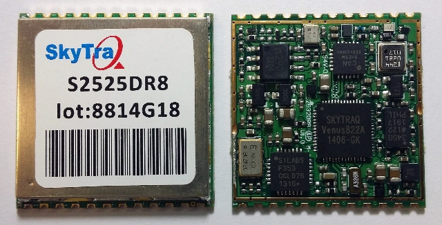
SkyTraq Technology, Inc., a fabless GNSS positioning technology company, has introduced an all-in-one S2525DR8 GNSS dead-reckoning module, with integrating MEMS sensor and interface logic on-board. The module is designed for road vehicles requiring high accuracy 100 percent positioning availability.
The S2525DR8 offers accuracy for both indoor and outdoor positioning. It is based on SkyTraq’s Venus 8 multi-GNSS platform and uses a high-performance automotive-grade XV-8100CB analog output gyroscope and 16-bit differential ADC. A 3D option adds a barometric pressure sensor on-board, offering improved accuracy for altitude reading and altitude change detection over an accelerometer-based scheme in 3D dead reckoning.
Another monitoring option adds an accelerometer on-board, offering high-accuracy vehicle acceleration monitoring for driver behavior characterization, accident reconstruction analysis, or trigger event recording. The S2525DR8 is compact at 25 x 25 millimeters. It contains a level shifter on board, capable of direct interface to a vehicle odometer and forward/reverse signals ranging from 3V to 30V.
The SPI interface pins on the module allow autonomous data logging to an external SPI Flash memory device. For high-performance vehicle navigation systems, S2525DR8 provides continuous navigation inside tunnels and underground parking lots without signals; highly accurate barometric altitude enables identification of which level the vehicle is on in a stacked multi-level high-way or a multi-story car park. For automatic vehicle locating or fleet management systems, location can be identified immediately after power on, whether the vehicle is outdoors or indoors under a signal-denied environment.
The S2525DR8 provides reliable, uninterrupted position, speed and heading information in challenging environments; it is suitable for demanding vehicle navigation and tracking applications requiring the highest accuracy and availability, SkyTraq said. The S2525DR8 is now being manufactured in ISO/TS 16949 automotive-certified factories; an evaluation kit, sample, datasheet, and reference design are available now. A 3D option with barometric sensor and a vehicle-dynamics monitoring option with accelerometer will be available in the first quarter of 2015.
Ready-mix concrete transportation has long been a challenge for the fleet industry, as concrete is subject to unique time and maintenance limitations to prevent hardening during transit. To improve delivery efficiencies and monitor the integrity of this temperamental cargo, Road King Technologies, Inc., a fleet management and automation company, has integrated Hirschmann Solutions antennas, a supplier of antenna and transceiver systems for M2M (machine-to-machine) and automotive communications, to develop a more reliable fleet data-collection solution.
“As we continue to find ways to provide more data collection benefits to our concrete transport customers, we’re creating strategic partnerships with innovators like Hirschmann, who can help advance our technology,” said Harry Marks, president of Road King. “Our relationship with Hirschmann has been — and will continue to be — a fruitful partnership for years to come.”
Using Hirschmann roof antennas, Road King is able to maintain the best possible cellular and GPS signal connection for its GPS-enabled solution, which is directly installed in concrete delivery trucks. The technology requires constant connectivity to upload data from the truck, including water usage, quantity control and dispatch wait times every 30 seconds. This information is processed by the server and sent to clients in a graphic format showcasing the delivery status of every truck. As a result, customers can review the processed information to improve and adjust their transport systems, boost driver reliability across their organizations and increase overall efficiencies.
“The complexities of delivering ready-mix concrete makes it vital that cargo data collection is constant and reliable,” said Frank Homann, president of Hirschmann USA. “With Hirschmann’s antenna, we’re working with Road King to ensure their data collection solution can optimally operate in any condition, including areas where cellular connectivity can be a major issue.”
Ready-mix concrete trucks work in some of the most extreme cellular environments, such as downtown areas where tall buildings can create urban canyons that block or interfere with cellular transmissions and GPS signals. In some cases, deliveries are made in new urban areas, where cellular towers are not yet installed and service, if any, can be intermittent, at best.
Road King’s data collection technology using Hirschmann antennas is certified by the PTCRB (PCS Type Certification Review Board), an organization setup by network operators to test GSM (global system for mobile communications) devices, such as mobile phones, modules and M2M devices. PTCRB certification is a requirement for launching cellular devices on North American GSM carriers.
As part of European project MEDUSA coordinated by Telespazio (Finmeccanica/Thales), a workshop will be held in Tunis on Dec. 17 with stakeholders in civil aviation to promote the use of European satellite navigation systems in Libya, specifically EGNOS.
MEDUSA (Mediterranean follow-up for EGNOS Adoption) is a project funded by the European Commission as part of Euromed program GNSS with the objective of promoting the use of European satellite navigation services (E-GNSS), starting from EGNOS (European Geostationary Navigation Overlay Service) ahead of Galileo, in the Euromed area.
MEDUSA assists and prepares countries in the area (Algeria, Egypt, Jordan, Israel, Lebanon, Libya, Morocco, Palestine, Syria and Tunisia) in the adoption process of E-GNSS services, mainly in aviation as well as in other transportation sectors. To this end, MEDUSA implements a ”program of assistance actions” in countries from the area to transfer abilities, create technological capacities and share good practices.
Moreover, MEDUSA has created an operational and cooperation structure, called GEMCO (Galileo EuroMEd Cooperation Office), with a long-term working plan providing for the participation at a regional level of all beneficiary countries.
Located in Tunis, GEMCO acts as a reference point and catalyzer for all Euromed countries and towards Europe. Through GEMCO, MEDUSA favors initiatives connected to E-GNSS in the Euromed region, and contributes to the implementation of assistance actions of the project like national and regional workshops, training sessions, and days dedicated to studying.
GEMCO will host the MEDUSA meeting with stakeholders of Libya’s civil aviation to analyze the country’s needs, identify priorities and help define a strategic vision in the short, medium and long-term in relation to the possible operative introduction of the use of EGNOS. Libya, which has repeatedly shown interest in the project and EGNOS (whose perspective of availability of coverage of respective service is provided for in the short and medium-term), represents an opportunity for EGNOS mainly in the aviation and helicopter sectors.
Telefónica and Geotab have announced an agreement to partner in Europe. The agreement will initially focus on the markets of Spain, Germany and the U.K., with the intention to explore Latin American markets in the near future.
The solution, which includes Geotab’s plug-and-play device, offers real time fleet management and the ability to develop a number of alerts, notifications, and review driver trip and activity reports. Advanced features also include on-board diagnostics through engine indicators to return feedback, such as engine failures, or an in-depth engine fault code diagnosis; detect accidents and retrace cause of the accident; and allow add-ons such as a navigational device, NFC driver ID key, sensors and more.
According to Geotab, the technology will help businesses improve their on-road productivity, on-road safety, and ecological efficiency, in addition to optimizing fleet performance to reduce fuel costs. Fleet managers will gain more intelligence across multiple vehicles giving them the data and insights needed to make more informed business decisions in real-time. Furthermore, drivers will have more insight over their individual vehicles.
Through this agreement, Telefónica extends its fleet management offer to further cover the global needs for its clients of both large corporations and small and medium size companies.
“We’re delighted to partner with Geotab, who through continuous innovation have many of the world’s largest fleets already using their product,” said Surya Mendonça the m2m managing director at Telefonica. “This agreement allows Telefónica to provide a best-in-class ‘plug and play’ fleet telematics product in Europe that reinforces our portfolio and gives our m2m customers further access to the strongest solutions.”
“We are seeing tremendous growth for fleet management solutions worldwide and the wireless carriers are now becoming an integral component of the fleet telematics and connected machine ecosystem. We are impressed by the Telefonica m2mteam and look forward to working together with Telefonica to deliver the most advanced fleet telematics solution in the market,” said Neil Cawse, CEO of Geotab.