Category: Defense

  • UHU Technologies: A lot more than anti-jam

    UHU Technologies: A lot more than anti-jam

    An interview with Chuck Stoffer, director of business development and Eric Hughes, design engineer at UHU Technologies. Click here to read more from this cover story. 


    UHU 1000 seven-element antenna array on a U.S. Army Stryker vehicle. (Photo: UHU Technologies)
    UHU 1000 seven-element antenna array on a U.S. Army Stryker vehicle. (Photo: UHU Technologies)

    What is your company’s main differentiator in the market?

    CS: Our big differentiator is our ability to detect and mitigate GPS spoofing. There are many products that perform jamming mitigation using multi-element antenna arrays, but they usually don’t operate below the noise floor on spoofers. Our big differentiator is the ability to go underneath the noise floor and locate the spoofing threat.

    About 10 years ago, our founder, Jeff Sanders, got interested in the GPS spoofing problem. Jeff’s previous company, Eclipse Electronic Systems, was dedicated to building high-end signals intelligence (SIGINT) receivers and the entire design team here at UHU worked for Jeff there. We built high-end, multi-channel receivers, often used in direction finding applications. When we started UHU, Jeff’s idea was to use direction finding to validate the constellation using satellite position.

    EH: Our system looks like an anti-jam system, which it is. However, it does a whole lot more than that. We use a controlled reception pattern antenna (CRPA) to do angle of arrival (AOA) measurements on each GPS satellite.

    We know where each satellite is supposed to be, then we calculate where it actually is in the sky. If a satellite is in the right spot in the sky, then we know that we can trust it. If it’s not — and, especially, if multiple satellites are not in the right spot in the sky — then we know there’s a spoofer.

    Once we’ve done that, we can take it a step further and perform non-adaptive spatial nulling, subtracting out the bad PRNs from the signals.

    Often people look at our system and think, “Oh, it’s an anti-jam system.” Yes, we do anti-jam, just like any other vendor out there would do, and we do the traditional adaptive null steering techniques, so that if there’s a jammer in the environment, we will automatically null it spatially. However, those systems don’t handle spoofers, which, as Chuck was saying, are often below the noise floor. Anti-jam systems — which are using power minimization techniques — will not do anything for something that’s below the noise. In fact, they may inadvertently amplify the weak signal because they weren’t designed to process signals below the noise.

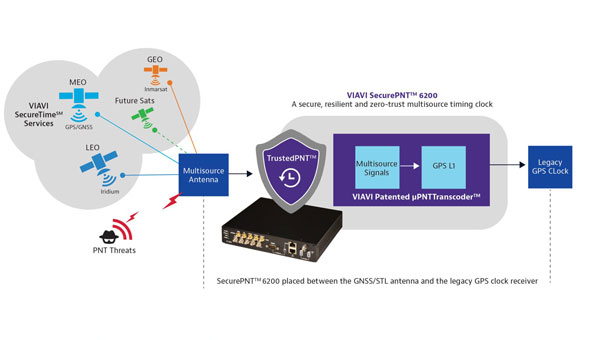
    As far as outputs, we provide a spatially validated PNT solution, meaning that we only include satellites whose sky position has been validated. We also provide an RF output that can feed other GPS receivers, including M-Code. Our products have a built-in web-based GUI for visualization of the threat environment, and all system measurements can be sent over the network using multiple industry standard protocols.

    To “precisely geo locate the source of GPS jamming or spoofing threats,” as one of your marketing materials says you can do, requires at least two bearings and the range.

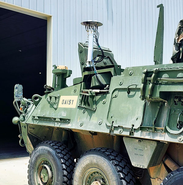
    EH: One of the nice things about our approach is that once we’ve identified a spoofer or a jammer, we can then tell you the line of bearing or the angle of arrival from the threat. Both of our products — the Northstar and the UHU1000 —also have a built-in event-based I/Q recorder and a GPS-disciplined oscillator that provides precision time. That gives us baseband data with precision timestamps anytime there’s a spoofing or jamming event. This is a standard feature that’s available right now.

    You can take multiple systems, network them together, and, if they all have a common view of the interference event, use the provided lines of bearing and precision time-stamped I/Q data to perform geolocation based on AOA and/or time difference of arrival (TDOA). This is a separate appliance that’s in development.

    In our next software release we are adding single-receiver, AOA-based geolocation. However, it requires motion. So, if you have a single UHH1000 in motion, you get a coarse geolocation automatically.

    CS: We’ve already demonstrated our geolocation algorithms on real-world data and our geolocation appliance is on our roadmap. We’ve proven the technology, and now we’re productizing it.

    This works very well for aerial platforms, because you get a lot of motion and many different looks at it. For ground-based applications, where the source could be many miles away and the AOA doesn’t really change much, it might not be as useful.

    How it the threat evolving and how are you dealing with that?

    EH: One of the advantages of our AOA-based approach is that it’s outside of the signal. It’s a physics thing that is very hard, if not impossible, to spoof. At government-sponsored events, every year they throw a new attack at the participants, often by modifying the signal in some novel way. Those are all great things that need to be tested, but we don’t care about any of that because all we’re doing is checking whether a satellite is in the right spot in the sky. If it’s in the right spot, we trust it. If it’s not, we don’t. Because of that, we’re well positioned to handle new threats.

    CS: We individually track every GPS satellite signal that we detect, even the same repeating pseudorandom noise (PRN) code coming from a different AOA. Each PRN gets its own hardware-accelerated tracking loop with its own beamformer. Once we know which PRNs are valid satellites and which PRNs are spoofers, we group and demodulate them separately. We provide the spoofer PNT solutions to the user in real-time.

    Are all your boxes multi-constellation?

    EH: Today, we process L1 C/A and L2C. Since L1 C/A is the backbone of most GPS receivers, effective spoofing attacks always spoof L1 C/A, and that has been our focus area. Of course, we have a roadmap to do more.

    To the extent that you are at liberty to tell me, who has your box? Who will have it?

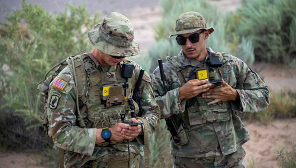
    CS: Army and Air Force customers have our boxes.

  • VIAVI launches resilient PNT solution

    VIAVI launches resilient PNT solution

    Photo: VIAVI Solutions
    Photo: VIAVI Solutions

    VIAVI Solutions has released SecurePNT 6200 with SecureTime services, to enhance the resilience and precision of positioning, navigation and timing (PNT) for infrastructure operations globally.  

    The solution integrates the Fugro AtomiChron timing service, to improve security against emerging threats to global infrastructures, such as 5G networks, transportation systems and financial services. 

    SecurePNT 6200 offers a multi-source PNT service that combines signals from various orbital positions — geosynchronous (GEO), low-Earth Orbit (LEO), and medium-Earth Orbit (MEO) — with traditional GNSS constellations, offering a zero-trust, multisource assurance framework. This setup is designed to protect against the vulnerabilities of public GNSS signals, which are critical for the timing and synchronization of essential services that can be disrupted by jamming, spoofing or satellite attacks. 

    The SecurePNT solution incorporates several key technologies to ensure robust protection: 

    • Anti-spoofing: Detects and mitigates spoofing attacks, ensuring the integrity of navigation and timing data. 
    • Authentication: Extends beyond the Galileo Open Service Navigation Message Authentication (OSNMA), offering enhanced security measures across all GNSS constellations. 
    • Encryption: Protects the integrity and confidentiality of PNT data transmission. 
    • High accuracy: Delivers timing accuracy of less than 5 ns, with an optional upgrade to less than 1 ns, all traceable to UTC/NIST standards. 

    SecurePNT 6200 can be easily integrated into existing systems. It features VIAVI’s µTranscoder technology, which allows users to upgrade their legacy GPS/GNSS systems effortlessly. This technology allows a simple retrofit of the SecurePNT 6200 between an existing GPS/GNSS antenna and its receiver to improve resilience without the need for extensive hardware modifications. 

    The solution aligns with various government and industry standards, ensuring compliance with the latest guidelines from the Department of Homeland Security (DHS),   

    National Institute of Standards and Technology (NIST) and other regulatory bodies. SecurePNT 6200 aims to support the security and operational needs of critical infrastructures worldwide.

  • Rohde & Schwarz, XipLink partner for intelligent multi-orbit networking

    Rohde & Schwarz, XipLink partner for intelligent multi-orbit networking

    Photo: ipoque
    Photo: ipoque

    ipoque, a Rohde & Schwarz company and provider of deep packet inspection (DPI) software for networking and cybersecurity solution providers, has entered a technology partnership with XipLink, a global technology that provides optimized, secure and intelligent multi-path hybrid networking.

    Under the partnership, ipoque will integrate its DPI technology, R&SPACE 2, into the XipLink operating system (XipOS) to create the XipLink Application Classification Engine (XipACE). This technology is designed to deliver advanced application visibility for multi-orbit networking.

    Layer 7 visibility for multi-orbit networking

    Using standards-based space communications protocol specifications (SCPS) protocol acceleration, link bonding, Layer 2 switching and Layer 3 routing, XipLink offers intelligent multi-orbit networking that ensures network performance and quality of service QoS across satellite, cellular and wireless networks. Embedding the next-gen DPI software R&SPACE 2 introduces traffic visibility up to Layer 7 and beyond, powering the traffic aggregation and optimization algorithms used by XipLink.

    R&SPACE 2 combines behavioral, statistical and heuristic analysis with metadata extraction to identify protocols, applications and application attributes in real time.

    “Our breakthrough AI-based encrypted traffic intelligence, which includes machine learning and deep learning techniques, and high-dimensional data analysis, brings traffic awareness to the next level by identifying any type of IP traffic, despite encryption, obfuscation and anonymization,” said Martin Mieth, P.hD., vice president of engineering at ipoque.

    Offers high-performance networks

    By integrating R&SPACE 2, XipACE can augment quality of service (QoS) management, traffic analytics, steering decisions, load balancing and dynamic link bonding. R&SPACE 2 also features an extensive feature and plug-in set, such as first packet classification, customizability of app signatures or tethering detection.

    Insights from R&SPACE 2 allow XipOS to support network diversity and resilience, from offloading traffic from congested pathways to tapping into GEO satellites to alleviate latency issues. At the policy level, it enables application prioritization and SLA compliance.

    As more and more applications require high bandwidth and low latency, the granular traffic analytics offered by R&SPACE 2 can help users optimize their networks and improve resource efficiency. These insights seek to lay the foundation for autonomous and self-healing networks through data-driven decision-making.

    The technology is designed for mobile, satellite, maritime, government and defense sectors, as well as modem OEMs.

  • Shift5 launches GPS integrity module

    Shift5 launches GPS integrity module

    Photo:Shift5 — an onboard operational data company — has released the Shift5 GPS integrity module, a platform-agnostic solution for military, aviation, rail, maritime and space applications.

    With real-time access and analysis of onboard data, the module assesses changes in navigational position through multi-faceted anomaly detection methods, which alert operators to GPS spoofing attacks as they happen.

    Using data collected from onboard systems, the module uses algorithmic position analysis to identify significant position deviations and GPS data validation to verify GPS information accuracy. Discrepancies or deviations that indicate tampering trigger an immediate notification, allowing operators to initiate standard operating procedures (SOPs) rapidly and accurately.

    The Shift5 GPS Integrity Module is designed for cross-platform deployment, across commercial and military planes, locomotives, vessels and aircraft, as well as on other critical systems such as radar, unmanned aircraft systems (UAS) and weapon guidance systems. It seamlessly integrates with existing platforms and can deploy directly to onboard hardware.

    GPS spoofing poses significant threats to national defense and commercial transportation systems, from navigational errors to compromised operational safety — especially in contested or congested environments.

    “We are in an era of electronic warfare, defined by the use of hybrid threats on the battlefield,” said Egon Rinderer, CTO, Shift5.  “The use of cyber-physical weaponry isn’t restricted to one particular theater of conflict and isn’t aimed toward military targets alone…The answer to how we combat these types of GPS attacks comes down to data. Observability into onboard data quantifies the risk posed by GPS spoofing.”

    This technology offers multi-faceted detection and alerts for GPS spoofing attempts, designed to improve the safety and reliability of navigation systems. It uses physics-based spoofing detection to determine if changes in position are physically possible to provide an effective method for initial spoofing detection. The system analyzes data from all sources to detect subtle, sophisticated spoofing attempts, which is essential for identifying more complex spoofing strategies that may evade traditional detection spoofing techniques.

    Shift5 alerts can be integrated into existing SOPs to help preempt contamination of other positioning and navigation data, such as inertial navigation calibration against false GPS data. Metadata about the time, location, duration and estimated position of the attack can be passed for inclusion in threat mapping and other geospatial systems for future route avoidance.

  • RapidFlight launches Mobile Production System

    RapidFlight launches Mobile Production System

    Photo: RapidFlight
    Photo: RapidFlight

    RapidFlight has released its Mobile Production System (MPS), designed for the manufacturing and deployment of UAVs from forward locations.

    MPS can be owned and operated by RapidFlight or used by the US Department of Defense (DOD), its allies and defense contractors as an effective way to mass manufacture UAVs across the globe.

    A single MPS can produce 28 Group 3 aircraft per month — or much higher quantities for Group 2 and/or Group 1. Each MPS unit can be operated independently or in coordination with other MPS units by two trained technicians.

    For example, according to RapidFlight, 2,500 or more Group 3 UAVs of the same or varying designs can be manufactured in a year by deploying as few as eight MPS units. MPS are easily transported by traditional ground, sea or air vehicles.

    MPS uses commercial off-the-shelf (COTS) components for ease of global deployment and compliance with DOD requirements. They are powered via any 110v to 240v AC power source and are designed to function in the same environments in which the warfighter is deployed. MPS can handle wet, dry, hot, cold, clean, and dirty environments with operational limits currently set from -20º F to 130º F and high humidity.

    RapidFlight engineers have optimized the hardware and software technology stack specifically for MPS capabilities to give users the flexibility to quickly deploy new designs or iteratively add additional aircraft capability for constantly evolving needs.

    Additional benefits include a small logistical and operational footprint, a more resilient supply chain and minimized inventory. With multiple MPS units deployed in strategic locations, users can quickly create a distributed and resilient network of UAS production and support even in remote areas and harsh environments.

  • SSC completes software upgrade for OPIR monitoring

    SSC completes software upgrade for OPIR monitoring

    Photo: SSC
    Photo: SSC

    The Space Systems Command (SSC) Space Sensing program executive office, headquartered at Los Angeles Air Force Base in El Segundo, California, has delivered the first of two future operationally resilient ground evolution (FORGE) software deliveries to operations in the Overhead Persistent Infrared (OPIR) Battlespace Awareness Center (OBAC) at the Buckley Space Force Base in Colorado.

    The integration of the FORGE framework into OBAC operations offers increased cyber resilience and enhanced mission applications to operators. OBAC operations on FORGE aim to boost OPIR battlespace awareness and technical intelligence missions with significant cyber-security improvements and enhanced missile detection and tracking.

    Additionally, the operational trial period preparing for this delivery provided opportunities to stress the FORGE framework with real-world events. Notably, the framework performed in family with the legacy system, enabling the battlespace awareness and technical intelligence mission as the OBAC’s operational baseline.

    FORGE provides OPIR data to operational warfighters and allows the U.S. Space Force to pivot toward a resilient missile warning, tracking and defense architecture. The FORGE ground system will support continued operations of legacy Space Based Infrared System (SBIRS), as well as the next generation of OPIR sensors including Next Gen OPIR GEO & Polar, and Resilient Missile Warning / Missile Track medium-Earth orbit (MEO) space systems. It has a cyber-resilient, flexible, scalable and government-owned open architecture to support the development, integration and delivery of OPIR processing applications for rapid response to emerging threats.

    “Our nation’s ability to quickly sense and make sense of OPIR observations is crucial in maintaining decision-making advantage against adversarial threats and their advanced missile technologies,” said U.S. Space Force Col. Robert Davis, Space Force program executive officer for Space Sensing. “This effort enables target tracking earlier and for a longer duration, which significantly increases the event custody chain. Timely response to threats requires a modern architecture capable of hosting data from a range of new and legacy sensors that enables the development of applications to address these threats.”

    The FORGE framework promotes open architectures designed to maximize the use of the OPIR constellation and allow for new capabilities to be added frequently and efficiently. It uses existing commercial off-the-shelf (COTS), government off-the-shelf (GOTS), and free or open-source software (FOSS) products to offer users a rapid pivot to new solutions depending on mission needs. This strategy enhances the opportunities for a broad range of vendors and strengthens the government’s access to the latest industry innovations, thereby increasing resiliency in the weapon system and industrial base, according to SSC.

  • Nearthlab debuts counter UAS technology in the US

    Nearthlab debuts counter UAS technology in the US


    Photo: Nearthlab
    Photo: Nearthlab

    Nearthlab has unveiled its latest counter-unmanned aircraft system (CUAS) technology.

    The system is a high-speed kinetic interceptor UAS that utilizes advanced autopilot algorithms for calculating and tracking precise target trajectories, neutralizing Group 1 and 2 aerial threats with pinpoint accuracy.

    Additionally, Nearthlab has released AiDEN, an autonomous drone designed for diverse operational contexts, including intelligence, surveillance and reconnaissance (ISR) missions, emergency response programs and infrastructure inspections.

    Nearthlab’s solutions, including the CUAS UAV and AiDEN, are manufactured in accordance with the National Defense Authorization Act (NDAA). The company strictly adheres to NDAA standards to ensure that its UAVs meet the federal requirements necessary for immediate deployment in both military and industrial settings in the United States.

  • Hexagon | NovAtel upgrades GNSS resilience and integrity technology

    Hexagon | NovAtel upgrades GNSS resilience and integrity technology

    PhotoPhoto: Hexagon | NovAtel
    Photo: Hexagon | NovAtel

    Hexagon | NovAtel has launched the NovAtel Application Suite Version 2.0, now including GNSS Resilience and Integrity Technology (GRIT). The GRIT Monitor application allows users to observe radio frequency (RF) interference through a comprehensive dashboard to make informed decisions to maintain robust positioning.

    GRIT is RF interference detection and mitigation technology available on all OEM7 GNSS receiver products, including individual cards and enclosures such as smart antennas, PwrPak and MarinePak.

    GRIT Monitor is a RF interference software visualization tool to offer a real-time, at-a-glance interface of all relevant data in a single dashboard view.

    It includes positioning and device status overviews to serve as a mitigation assistant that indicates whether interference is detected. It features an interactive spectrum viewer, which shows all constellations and frequency bands (spectrum and waterfall), and a signal matrix indicating the signal quality and interference status by frequency band and constellation.

    The updated suite also introduces improvements to user interface, firmware compatibility and extends support to include MarinePak among other enhancements. The Manage application, previously known as Setup and Monitor, now supports satellite tracking for L-Band and SBAS and offers a global map view of connected receivers.

    Version 2.0 of the NovAtel Application Suite is designed to assist users in maintaining accurate GNSS positioning by quickly identifying and responding to RF interference. This update is targeted at industries that require precise location data, such as aerial mapping, agriculture and autonomous vehicle navigation.

    To access the new GRIT Monitor application, download NovAtel Application Suite Version 2.0 at https://bit.ly/3weNXbi.

  • MerlinTPS advances GNSS-independent positioning

    MerlinTPS advances GNSS-independent positioning

    Soldiers from the 101st Airborne Division conduct at terrain walk using the Dismounted Assured Positioning System during the 2023 PNTAX. (Photo: U.S. Army)
    Soldiers from the 101st Airborne Division conduct a terrain walk using the Dismounted Assured Positioning System during the 2023 PNTAX. (Photo: U.S. Army)

    MerlinTPS has tested its Terrestrial Positioning System (TPS) at the Department of Defense (DOD) PNT Assessment Exercises (PNTAX), demonstrating resilience against electromagnetic radio frequency interference. This test positions TPS as an alternative to GNSS-based systems in environments where GNSS is compromised or unavailable.

    PNTAX is designed to evaluate positioning, navigation and timing (PNT) technologies under conditions where traditional GPS signals are degraded or denied. MerlinTPS’s system uses broadcast radio signals, which are less susceptible to jamming and spoofing than satellite signals, to provide positioning and timing data.

    The company is also working to enhance the portability and integration of TPS, collaborating with a RISC-V core engineering firm to reduce the size of their neuromorphic design, facilitating easier integration into OEM devices.

    Throughout the PNTAX, Persistent Systems’ MPU5 radios supported backhaul communications reliably, even under ha­rsh environmental conditions.

    The tests at PNTAX represent a step forward for MerlinTPS in moving towards commercial deployment, with the goal of providing an alternative and reliable PNT solution across various industries globally, according to the company.

  • TrustPoint improves GNSS solutions for US Air Force

    TrustPoint improves GNSS solutions for US Air Force

    Photo: Trustpoint
    Photo: TrustPoint

    TrustPoint, a commercial GPS and navigation technology company, has been awarded a Phase II Small Business Technology Transfer (STTR) contract by AFWERX, totaling $1.6 million. The contract focuses on the development of advanced, resilient navigation applications to meet the challenges faced by the Department of the Air Force.

    In collaboration with the Naval Postgraduate School, TrustPoint aims to enhance its GNSS capabilities and pave the way for applications that will boost the national defense of the United States.

    The Air Force Research Laboratory (AFRL) and AFWERX have partnered to optimize the Small Business Innovation Research (SBIR) and STTR processes. Their efforts aim to provide quicker proposal-to-award timelines, broadening the applicant pool to include more small businesses and reducing bureaucratic overhead through ongoing process improvements. Since the initiation of the Open Topic SBIR/STTR program in 2018, the DAF has expanded the scope of innovations it funds, with TrustPoint’s project commencing on April 2, 2024.

  • Australian Space Agency funds development of aerospace-grade GNSS receiver

    Australian Space Agency funds development of aerospace-grade GNSS receiver

    Photo: Gilmour Space
    Photo: Gilmour Space

    The Australian Space Agency has funded the development of an Australian aerospace-grade Global Navigation Satellite System (GNSS) receiver to use in rockets, satellites and aircraft under its Moon to Mars Supply Chain Capability Improvement Grants scheme.

    Gilmour Space Technologies, in collaboration with the University of New South Wales (UNSW), will co-develop the GNSS receiver using an Australian supply chain and qualify it for use across a wide range of positioning, navigation and timing (PNT) applications. The GNSS receiver will be based on proven technology from UNSW, benefiting from Gilmour Space Technologies’ space manufacturing expertise and commercialization efforts.

    Kody Cook, head of software, electrical, GNC and avionics at Gilmour Space Technologies, highlighted the importance of this initiative for the nation’s aerospace endeavors. “With the future becoming less certain, we’re thankful that Australia is investing in the sovereign development of exactly these types of fundamental capabilities,” he said. “If we could use more Australian-made avionics in our launch vehicles and spacecraft, we would.”

  • GPS disruptions in Tel Aviv as Israel braces for possible Iranian attacks

    GPS disruptions in Tel Aviv as Israel braces for possible Iranian attacks

    Photo: Oren Kfir / iStock / Getty Images Plus / getty Images
    Photo: Oren Kfir / iStock / Getty Images Plus / Getty Images

    On April 4, residents of Tel Aviv, Israel, noticed that map applications on their phones such as Waze, Google Maps and the taxi pickup app Gett were placing them in Lebanon’s capital, Beirut, 130 miles to the north. Cab drivers could not navigate and food-delivery apps were temporarily out of service, reported The Wall Street Journal.

    The spoofing was a result of the Israeli military tampering GPS signals to brace for possible retaliation by Iran or one of its allied militias after a suspected Israeli airstrike on an Iranian diplomatic building in Syria. The attack killed a senior Iranian general, Mohammad Reza Zahedi, and six other military officials. It has marked an escalation of the yearslong conflict between Israel and Iran.

    According to WSJ, analysts say a direct Iranian strike on Israel is unlikely. However, one day after Israel drafted reservists to boost air defenses, the Israeli military said it would pause all leave for combat units “in accordance with the situational assessment.”

    Israel has withdrawn some of its ambassadors and evacuated its embassies in multiple locations. With tensions and uncertainty rising, several Israeli municipalities near Tel Aviv put out announcements to calm residents and refresh guidance for emergencies.

    According to the Israeli military, the GPS spoofing — which can be used to confuse targeting systems for military weapons — was part of an effort to protect the country. “Today we initiated GPS disruption in order to neutralize threats,” said Israeli military spokesman Daniel Hagari. “We are aware that this disruption causes discomfort, but this is an essential and necessary tool in our defense capabilities.”

    Israel has ramped up GPS jamming and spoofing since the start of its war with Hamas in early October 2023, but mainly in the north of the country, where the Iranian-backed Hezbollah militia has rockets to strike Israeli towns and military bases, according to Reuters.

    The military has scrambled signals in southern Israel, mainly around the city of Eilat, the target of missile and UAV attacks by Iranian-backed Yemeni and Iraqi militias, according to Yigal Unna, former director general of the Israel National Cyber Directorate.

    The GPS disruptions have intensified since the most recent strike and have spread to central Israel where a local taxi driver shared that his map application had located him at the Rafic Hariri International Airport in Beirut. In the south of the country, and in Jerusalem and the occupied Palestinian West Bank, GPS devices placed users in Cairo, residents told WSJ.

    Mohammad Abdelhalim, founder of the Palestinian navigation app Doroob, said that signal interruptions have occurred regularly on various platforms that rely on GPS since the Oct. 7 Hamas-led attacks on Israel, ranging from a few minutes to several hours at a time.

    Spoofing can pose risks beyond being a nuisance for citizens. Distorting signals can create challenges for civilian and commercial planes that use GPS signals for navigation. Spoofing can also throw guided missiles off their trajectory, which poses unpredictable risks to civilians.

    The ramifications of the widening GPS blackouts remain unclear. Beyond the hassles for civilian drivers, there are safety concerns for emergency responders and commercial transit unable to reliably track locations.

    The recent spoofing in Tel Aviv is one of countless reminders that the country’s active military actions are only miles away and can have cascading effects on aspects of daily life.