EpiSci and Northrop Grumman have entered a strategic collaboration to develop and deploy advanced autonomous tactical solutions to the United States and its allies.
Under the collaboration, EpiSci’s TacticalAI software will be integrated into Northrop Grumman’s aeronautics system architecture. This integration is anticipated to significantly enhance the operational efficiency and success of warfighter missions through trusted autonomous technologies, according to EpiSci.
The collaboration uses the U.S. government’s open-architecture design, allowing Northrop Grumman’s autonomy solutions to incorporate third-party technologies. This allows UAVs to adapt to evolving mission requirements and offers military commanders greater flexibility in complex scenarios.
EpiSci’s TacticalAI technology is designed to improve autonomous solutions for human-machine teaming. It offers cognitive sensing, adaptive communications and networking systems, and battle management command and control (BMC2). This technology is being developed to enhance autonomous defense capabilities across a wide range of platforms, including uncrewed aerial and maritime systems, as well as tactical fighter aircraft.
The MCMF GNSS platform combines CMC’s certification with the digital signal processing expertise of Hexagon | NovAtel. Designed to detect GNSS signal spoofing, it islightweight and compact.
The increasing threat of GNSS signal jamming and spoofing is not limited to military concerns. It has started to impact global commercial aviation and civilian sectors as well. In response, CMC Electronics and Hexagon | NovAtel seek to introduce a new era of MCMF GNSS positioning and assured positioning, navigation and timing (APNT). The collaboration aims to provide maximum reliability and dependability in solutions for the military, commercial aviation and unmanned aerial systems (UAS) sectors.
Under the partnership, CMC Electronics’ new receiver, which is certified to the exacting DO-254 Level A standards, is integrated with Hexagon | NovAtel’s GNSS measurement technology.
Based in Montreal, Canada, with additional facilities in the U.S., CMC Electronics designs and manufactures cockpit systems integration, avionics, display solutions and high-performance microelectronics for the military and commercial aviation markets. Hexagon’s Autonomy & Positioning division delivers comprehensive solutions for assured positioning across various applications, designed to progress autonomous technologies in essential industries.
The Canadian Coast Guard (CCG) has awarded a contract to Zighra, an artificial intelligence (AI) solutions and cybersecurity provider, for its GenesysInsights platform. This technology will enhance the safety and security of Canada’s maritime territories by providing a previously unattainable level of analysis.
GenesysInsights combines AI interpretability and multi-sensor fusion, designed to offer automated threat detection and comprehensive situational awareness in maritime environments. The platform synthesizes information from Global Navigation Satellite System (GNSS) signals and terrestrial and space-based Automatic Identification System (AIS) data, which aids the CCG in detecting and responding to maritime threats. This initiative is part of the Innovative Solutions Canada program.
Position, navigation and timing (PNT) technology — integral to a range of critical applications, from military operations guidance to everyday smartphone navigation — has propelled commercial advancement. Despite its widespread utility, the susceptibility of these systems to manipulation presents significant threats, including unauthorized vessel activities and sophisticated cyber-attacks, such as jamming and spoofing.
GenesysInsights aims to transform the security of government infrastructure and operations by creating a cyber-secure digital environment across land, sea and space. The platform uses advanced machine learning algorithms to analyze a variety of sensor data inputs. By monitoring ship movements and communications alongside satellite signal integrity, the technology will detect unusual patterns or anomalies indicative of potential risks.
This pilot project will significantly improve real-time monitoring and analysis of maritime activities to boost safety and security across Canada’s maritime waterways.
It can quickly detect and respond to maritime threats, including sophisticated cyber-attacks, and has an integrated operational command system with automated alerts to enhance decision-making and coordination.
The CCG’s successful implementation of GenesysInsights could lead to broader adoptions in various critical infrastructure sectors such as aviation, ground transportation, logistics, space operations and national security, the company said.
Quickly prototype a GNSS interference detection and reporting system.
Implement an internet-based High Accuracy and Robustness Service (HARS)for GPS.
Relax export controls that currently restrict use of adaptive anti-jam antennas.
These are just three of the efforts the U.S. government is pursuing as a result of recommendations from the President’s National Space-based Positioning, Navigation and Timing (PNT) Advisory Board.
For 20 years the PNT Advisory Board has been providing the government independent expert advice about GPS and PNT.
Established by presidential directive in 2004 and administered under the Federal Advisory Committee Act by NASA, its charter has been regularly renewed. The charter provides that the board shall:
Be composed of experts from outside the United States government.
Seek input from state and local governments, industry and academia on developments in the application of space-based PNT technologies.
Evaluate national and international needs for changes in space-based PNT capabilities and assess possible trade-offs among options.
Provide independent advice and recommendations to the National PNT Executive Committee (co-chaired by the Deputy Secretaries of Defense and Transportation) on policy, system requirements, and program needs.
While “space-based” is in its name and charter, the board has long recognized that terrestrial assets also can play an important role in serving PNT users by augmenting, reinforcing, and complementing GPS. The use of complementary systems, for example, could help demotivate intentional jammers and spoofers and help safeguard users during any interference event. Thus, the board often considers a wide range of capabilities and systems.
The board also discusses policy, education, international relations and other issues important to the PNT community. As one board member commented, “Technology doesn’t exist in a vacuum. It is developed by, and intended to serve, people. If you don’t recognize that, you are missing most of the picture.”
The current board’s membership includes an impressive array of experts in PNT policy and technology. Its 29 members include a former governor, a retired admiral, three retired generals, GPS’ original chief architect, a former undersecretary, a former assistant secretary, three former presidents of the Institute of Navigation (ION), three international members and experts from across academia and industry.
Chaired by former Coast Guard Commandant Admiral Thad Allen, the board’s primary efforts are driven by its six subcommittees, reflecting a holistic approach to effective PNT:
Strategy, Policy & Governance
Protect, Toughen & Augment
Emerging Capabilities, Applications & Sectors
Education & Science Innovation
International Engagement
Communications & External Relations
While the subcommittees meet in fact-finding sessions to gather data, the PNT Advisory Board’s deliberations are public. Semi-annual meetings inWashington, D.C. and other locations may be attended by anyone, either in person or virtually. Announcements on the board’s webpage and in the Federal Register provide details before each meeting. By law, the minutes of each meeting are available to the public, and video recordings of meetings are normally posted as well.
Input from the public about PNT issues of concern is also welcome to inform the board’s current and future deliberations. Information on how to send input will be posted with the meeting announcement here.
According to board member Jeff Shane, former undersecretary at the U.S. Department of Transportation (DOT), the PNT Advisory Board is evidence of government at its best. “The very fact that the board was established underscores our government’s willingness to hear and consider the widest variety of views and input. It should be a source of optimism, and even pride, for the entire PNT community.”
National Space-based PNT Advisory Board
The next meeting will be from 9:00 a.m. to 6:00 p.m. MDT, April 24, 2024, and from 9:00 a.m. to noon April 25 at The Antlers Hotel in Colorado Springs, Colorado.Click here for information on a reception on April 23, featuring Gen. David Thompson.
A plane carrying British Defense Secretary Grant Shapps had its satellite signal jammed as it flew near Russian territory, the government reported on March 14.
The government said that the Royal Air Force jet carrying Shapps, officials and journalists “temporarily experienced GPS jamming when they flew close to Kaliningrad” on a flight from Poland to the UK.
The Times of London, whose reporter was onboard, said that for about 30 minutes mobile phones could not connect to the internet and the aircraft was forced to use alternative methods to determine its location.
Kaliningrad is a Russian enclave bordered by Poland and Lithuania, home to the Russian Navy’s Baltic Fleet. Prime Minister Rishi Sunak’s spokesman, Dave Pares, said “the jamming didn’t threaten the safety of the aircraft at any point.” He added that it is not unusual for aircraft to experience electronic jamming near Kaliningrad.
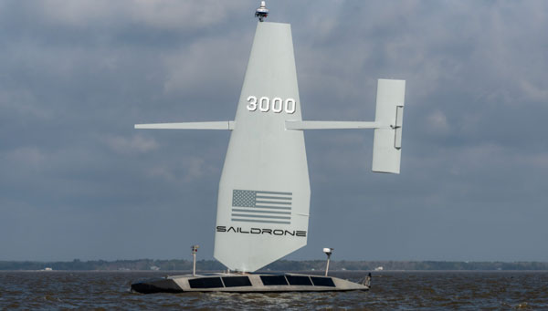
Saildrone has released its first aluminum Surveyor unmanned surface vehicle (USV) off the Austal USA production line in Mobile, Alabama. Chief of Naval Operations (CNO) Lisa Franchetti was on site to inspect the vehicle, ahead of these new USVs being tested under contract to the U.S. Navy.
The Surveyor USV is primarily designed for ocean mapping and maritime domain awareness. The wind, solar power and a diesel generator for long-range, long-endurance missions in the open ocean power it.
The Surveyor is equipped with the latest multibeam sonar technology, which enables it to map the seafloor up to a depth of 11,000 m. Additionally, it can carry defense and security payloads that are specifically designed to detect and respond to various maritime threats and challenges.
Upcoming Navy missions will focus on the ability of the Surveyor to deliver both surface and undersea intelligence for a range of high-priority applications, including anti-submarine warfare (ASW).
To meet the increasing demand for Surveyor USVs, Saildrone partnered with Austal USA, an Alabama-based ship manufacturer, to produce one Surveyor every six weeks, with the ability to scale up production as demand requires.
At 20 m long and weighing 15 tons, the Surveyor classifies as a medium USV, built to American Bureau of Shipping (ABS) Light Warship code. These first Surveyors are contracted to the U.S. Navy to test and evaluate Surveyor-class vehicles in multiple environments.
Abracon has introduced a new series of GNSS RF antennas designed to elevate location-based services with enhanced accuracy and precision. This new lineup aims to outperform conventional GPS technologies by offering faster signal acquisition, improved tracking capabilities and reduced power consumption.
The antennas support a full spectrum of bands, including L1, L2, L5, and L-band data correction services. It can be used in a variety of sectors — such as agriculture, surveying, the Internet of Things (IoT), mapping, defense and aviation.
The technology is designed to meet the rigorous demands for precise location data across various applications. These antennas offer multi-band and multi-constellation support to ensure broad compatibility. With centimeter-level accuracy, these antennas are crucial for aerospace, defense, asset tracking, geolocation, precision agriculture and industrial IoT.
The civil infrastructures behind safety-critical applications in aviation, maritime and terrestrial navigation rely heavily on global navigation satellite system (GNSS) signals. The civil GNSS signal structures are vulnerable to spoofing attacks, which can endanger public safety.
In this work, the authors introduced an optimal cumulative position-domain innovation (CPI) monitor to detect spoofing by accumulating tracking errors embedded in the spoofer’s signal. The authors also derived relationships between missed detection probability, tracking error magnitude and monitor run time to show that even with decimeter-level tracking error, the monitor can detect spoofing with a low probability of missed detection in less than 1 minute.
The team of researchers evaluated the performance of the CPI monitor for both white and time-correlated (colored) tracking errors. To compute protection levels and detect short-duration spoofing, researchers proposed a complementary solution separation (SS) monitor to implement in sequential, overlapping windows to compare the integrated INS/GNSS position solution against an inertial navigation system (INS) coasting solution. The INS-only coasting element allows the system to maintain positioning continuity after detection, albeit at lower accuracy, as the INS drifts.
The experimental results indicate that implementing a CPI monitor can dismiss the conjecture that INS-based spoofing detection is susceptible to slowly deviating counterfeit signals. It was found that if the duration of the spoofing event exceeds a minimum time defined by the variance and time constant of the tracking error, the spoofer’s target tracking error can be detected.
Birendra Kujur, Samer Khanafseh and Boris Pervan; “Optimal INS Monitor for GNSS Spoofer Tracking Error Detection.”
Space-Time Adaptive Processing
Antenna arrays and spatial processing techniques are among the most effective countermeasures against GNSS signal interference. In this paper, the authors propose a new array concept, space-time adaptive processing (STAP), that consists of spatially distributed subarrays small enough to fit inside the non-metallic parts of an automobile. The device is designed to be installed in bumpers or side mirrors.
During the experimental testing, the authors used beamforming algorithms for the array to perform against jammers in the GPS L5 and Galileo E5a bands. The authors composed a GNSS jamming scenario to compare conventional space adaptive processing (SAP) methods and the new STAP method using real-life measurements in a dynamic scenario. In this simulation, the car was rotated 360° throughout the complete measurement. The comparison between the received signal quality demonstrated an improvement for wideband signals.
The results demonstrate that the performance of the STAP was dependent on the number of taps analyzed in the testing simulation that included different fractional delays. Overall, the research showed STAP could outperform SAP implementation in applications requiring robust tracking, as it was able to process all satellites for an additional 12 seconds.
Marius Brachvogel, Michael Niestroj, Michael Meurer, Syed N. Hasnain, Ralf Stephan and Matthias A. Hein; “Space-Time Adaptive Processing as a Solution for Mitigating Interference Using Spatially-Distributed Antenna Arrays.”
Enabling RTK Positioning Under Jamming
New GNSS applications demand high position accuracy and resilience against radio frequency interference. Separately, these demands can be fulfilled by multi-antenna systems using spatial filtering and carrier-phase positioning algorithms, such as real-time kinematics (RTK), respectively. However, combining these approaches creates a severe issue: the spatial filtering induces a phase offset into the measured carrier phase leading to a loss of position accuracy.
This paper presents a new approach to compensate for the phase offset without knowing the antenna array radiation pattern or the direction of arrival of the signals. The proposed algorithm was tested in two different scenarios using an in-house software receiver in combination with the RTKlib — an open-source program package for GNSS positioning — that was used to estimate an RTK solution. In the first scenario, the signal power of a jammer from a constant direction of arrival (DoA) was raised stepwise. In the second scenario, a jammer with constant signal power was moved around the receiver antenna array. For both scenarios, the proposed algorithm was compared with a multi-antenna system not compensating for the phase bias and with a single antenna processing.
It is most suitable in situations where a medium-to-high precision (dm to cm) solution must be resilient to interference. A very high precision solution (cm to mm), comparable with a geodetic receiver accounting for antenna phase center variations, cannot be achieved with this algorithm.
In this paper, the signal recording and processing time was limited to less than half an hour. The carrier-phase offset produced by the proposed algorithm may become larger over longer observation times. Evaluating this is part of future work.
Tobias Bamberg, Andriy Konovaltsev and Michael Meurer; “Enabling RTK Positioning Under Jamming: Mitigation of Carrier-Phase Distortions Induced by Blind Spatial Filtering.”
Several layers of defense can be implemented in a GNSS receiver to improve its performance in the presence of interference. These layers include the use of pre-correlation mitigation techniques, post-correlation quality indicators to screen measurements and fault detection and exclusion (FDE) at the position solution level.
This paper provides a characterization of the interactions between these layers of interference mitigation and a measurement quality check. Data collected in the presence of increasing levels of jamming were processed using different interference mitigation techniques, including robust interference mitigation (RIM) and the adaptive notch filter (ANF). A software-defined radio (SDR) approach was used, and measurements were generated by considering five interference-mitigation techniques. Position solutions were then computed using a forward-backward approach for receiver autonomous integrity monitoring (RAIM). Signals from GPS, Galileo and BeiDou were processed and both single and dual-constellation solutions were analyzed.
The results demonstrated that interference mitigation allowed the receiver to track a larger number of signals even in the presence of high levels of jamming power. This increased measurement availability was then effectively exploited by RAIM techniques to provide more reliable solutions. Measurements from several constellations further improved the reliable availability of the position solutions.
Ciro Gioia and Daniele Borio; “Multi-layered Multi-Constellation Global Navigation Satellite System Interference Mitigation.”
BAE Systems has been awarded a contract by Boeing to enhance the U.S. Navy’s MQ-25 unmanned aerial refueling system with a modernized vehicle management system computer (VMSC). This upgrade aims to enhance the computing power of the MQ-25 and address both obsolescence issues and overall aircraft performance for future operations.
The MQ-25 — recognized as the Navy’s inaugural operational carrier-based UAV — is primarily tasked with aerial refueling capabilities designed to alleviate the burden on F/A-18 aircraft and improve the fleet’s operational flexibility.
The next-generation VMSC developed by BAE Systems is key to controlling the MQ-25’s flight surfaces and managing the vehicle. The upgrade is designed to enhance the MQ-25’s functionality and make its critical missions more efficient by consolidating hardware components into a single computer system.
The VMSC upgrade will incorporate quad-core processors, which augment the system’s computing power without increasing its size, weight, or power consumption. The selection of a multi-core processor, already qualified on another U.S. military platform, aims to mitigate cost, schedule, and integration risks associated with the MQ-25 program.
By replacing multiple onboard computers with a single VMSC, the upgrade is expected to improve aircraft reliability and decrease the total cost of ownership for the Navy. Additionally, the VMSC is designed to support the expansion of the MQ-25’s mission set, potentially including intelligence, surveillance and reconnaissance (ISR) capabilities, and to establish a foundation for future carrier-based unmanned systems through the implementation of manned-unmanned teaming (MUM-T) operational concepts.
The VMSC enhancement work is conducted at BAE Systems’ engineering and manufacturing facility in Endicott, New York, underscoring the company’s commitment to advancing the U.S. Navy’s unmanned aerial capabilities.
Scientific Systems has released upgrades for ImageNav, an image-based navigation software designed for GPS-denied or compromised environments.
With more than a decade of development, ImageNav offers a robust alternative to traditional GPS navigation for military operations, particularly in contested environments where jamming poses a threat to GPS reliability.
The demand for such technology has become increasingly critical considering enhancements to electronic warfare capabilities, with instances of GPS signal disruption impacting military assets. ImageNav is designed to address GPS vulnerability by offering precise navigation for a wide range of systems, including weapons, aircraft and uncrewed aircraft systems (UAS), without reliance on GPS signals.
ImageNav uses an onboard electro-optical (EO) or infrared (IR) digital camera and can employ three algorithms to analyze captured images and correlate them with stored terrain and image references. This process allows both absolute and relative navigation position updates. The technology can be integrated into air platforms as a software upgrade or as part of a self-contained hardware payload, minimizing size, weight and power (SWaP) requirements.
Scientific Systems is actively pursuing the integration of ImageNav onto GPS-guided munitions and UAS to operate in environments where GPS access is denied. Recent testing has demonstrated the technology’s capability to navigate without GPS and hit targets within required performance parameters.
Fairview Microwave has launched its advanced military-grade antennas. The new products include ruggedized GPS, manpack omni and vehicle omni antennas designed for mission-critical applications such as vehicle navigation, personnel communications, vehicle communications, electronic warfare and jamming.
The military-grade antennas meet MIL-STD-810 to offer durability while adhering to strict quality standards. The antennas are also compliant with the Trade Agreements Act (TAA), which makes them suitable for government and defense applications.
Built to withstand tough conditions, these antennas feature heavy-duty construction and a rugged design for long-lasting performance in challenging environments. They are designed to perform in extreme weather conditions and on rough terrains.
Its robust construction and NATO/U.S. standard mounting options aim to simplify integration into various setups during critical operations.
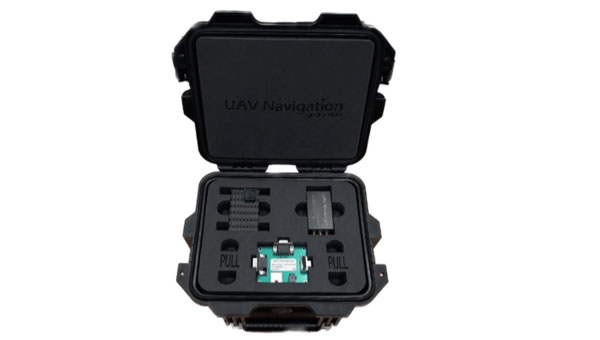
UAV Navigation-Grupo Oesía has released its GNSS-denied navigation kit designed to offer navigation capabilities in challenging environments.
The kit combines UAV Navigation’s attitude and heading reference system (AHRS), the POLAR-300, with its Visual Navigation System, the VNS01, designed to offer unmatched dead reckoning navigation capabilities with minimal drift.
The technology offers users improved navigational accuracy, with error rates as low as 0-1% over covered distances. This is made possible by the kit’s visual-based technology, which allows for precise attitude and position estimation to stabilize flights in challenging conditions. The kit is equipped with advanced algorithms that can detect and counter sophisticated spoofing and jamming techniques to offer reliable and secure navigation, even in the face of potential signal disruptions.
As technology advances and geopolitical challenges emerge, the demand for reliable and secure navigation for UAVs intensifies. Offering operational integrity in both the civil and defense sectors is paramount, especially with the rise of disruptive systems designed to interfere with radio-electronic navigation and communication.