Category: Defense

  • UAVOS announces S1-V300 MALE unmanned platform prototype

    UAVOS announces S1-V300 MALE unmanned platform prototype

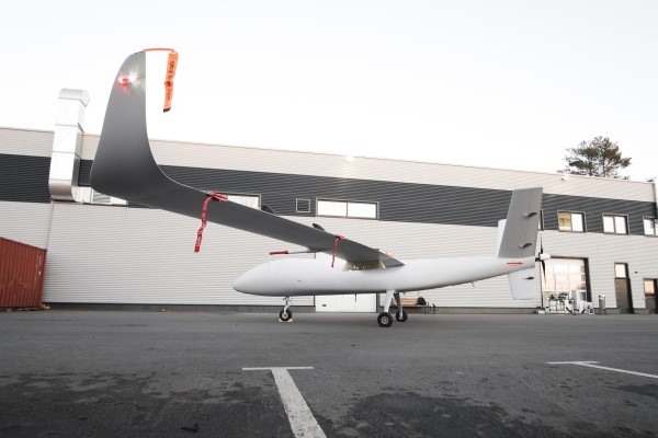
    UAVOS has successfully completed the S1-V300 medium-altitude long-endurance (MALE) unmanned aerial system (UAS) prototype designed to check basic aircraft systems.

    The advanced UAS model is based on the Saker MALE UAS design that achieved operational capability in 2020. The S1-V300 MALE UAS prototype is an upgrade to the unmanned system and features a new design and a more powerful heavy fuel engine with 260 HP offering greater speed, payload, and endurance of 28 hours with a range of 4,020 km.

    Work performed under UAVOS’ MALE UAS program using its proven Saker aircraft capabilities has enabled it to create a new-generation S1-V300 MALE unmanned platform. The aircraft features unique UAVOS avionics solutions and a redundant flight control system that will enable complex missions.

    The S1-V300 UAS will be able to support a variety of overland and maritime intelligence, surveillance and reconnaissance (ISR) missions. The improved S1-V300 prototype is equipped with both line-of-sight (LOS) and beyond-visual-line-of-sight (BVLOS) datalink systems for over-the-horizon operations. Additionally, the aircraft can be integrated with multiple ISR sensors, including electro-optical infrared (EO/IR) cameras and a synthetic aperture radar (SAR) that offers all-weather, day/night performance for a wide-area search capability.

    The S1-V300 MALE UAS next-generation capabilities combined with medium-altitude persistence make it a suitable platform to add with long-range radar, signals intelligence (SIGINT) payloads,  communication-relay payloads, and counter electronic-warfare systems. Additional retrofits include stronger wings and extra hard points for carrying an external payload of 300 kg.

    The S1-V300 has fully autonomous operation capability. It is equipped with automatic taxi-takeoff and landing systems, satellite communication for extended range, and fully redundant avionics. It is designed to operate in harsh environments and is adapted to perform in extremely hostile, dry and dusty ambient air. The aircraft features a 8.7-meters-long fuselage and a 18.7 meters wingspan, is capable of flying at 220 km/h, and has an endurance of more than 28 hours.

    The S1-V300 MALE prototype. (Photo UAVOS)
    The S1-V300 MALE prototype. (Photo UAVOS)
  • PAR Government rebrands GIS situational awareness solution

    PAR Government rebrands GIS situational awareness solution

    Sit(x) running on an iPhone. (Photo: PAR Government))
    Sit(x) running on an iPhone. (Photo: PAR Government))

    PAR Government, a provider of geospatial and decision support solutions for 57 years, has rebranded its TeamConnect cloud-based situational awareness suite as Sit(x). The commercial Sit(x) solution is designed for enhanced collaboration among government and civilian public safety organizations. PAR Government Systems Corporation (PGSC) is a wholly owned subsidiary of PAR Technology Corporation.

    The Sit(x) solution enables individuals and teams to communicate directly by text or symbology and share real-time full-motion video (FMV), geographic information system (GIS) layers, imagery, GPS-derived locations, raster maps, photos and documents.

    To complement the Android and Windows support already available in Sit(x), PAR is offering a free iOS app, giving Apple smartphone users access to the technology.

    “The Sit(x) name better reflects the ability to provide effective situational awareness for any situation,” said Mark Kozak, PAR Government vice president of Product Innovation. “This results in faster, more informed decision making at the command level and in the field.”

    Sit(x) is a TAK server-as-a-service solution based on the Team Awareness Kit (TAK) situational awareness technology that PAR Government developed for the U.S. defense and intelligence community under contract to the Department of Defense. This technology has been deployed under demanding conditions by every branch of the U.S. armed forces over the past decade.

    PAR Government created the Sit(x) TAK server-as-a-Service offering specifically to enable real-time communication and information sharing between non-connected public safety personnel during rapidly evolving multi-jurisdictional situations, both planned and unexpected. These include large public gatherings, such as sports events or concerts, and emergency incidents related to terror attacks or natural disasters.

    “Sit(x) can save lives, time, and resources by federating unrelated police and fire departments, U.S. government agencies, volunteer search-and-rescue groups, and even private security firms to collaborate as one coordinated entity during a major event,” Kozak said. “Due to its TAK lineage, Sit(x) opens the lines of communications between civilian public safety and the U.S. military, as well as our allies, with no export restrictions.”

    The PAR Government Sit(x) offering is a subscription to the Sit(x) TAK Server-as-a-Service software suite in the cloud. Ready in minutes, Sit(x) scales to handle teams of any size and is protected with end-to-end secure connectivity. The suite provides complete lifecycle management – event preparation, rehearsal, training, dynamic response, post-mission playback and analysis, and new response simulation.

    The investment by subscribing agencies is minimal because there is no computer hardware to purchase, and the end-user applications are available from the Google Play Store or Apple App Store for free. All server operations and software maintenance are managed 24/7 in the cloud by PAR.

  • Spire constellation helps detect GPS jamming in space

    Spire constellation helps detect GPS jamming in space

    Image: Spire Global
    Image: Spire Global

    Spire Global Inc., a provider of space-based data, analytics and space services, is using its constellation of about 40 geolocation satellites to detect GPS jamming. Spire is collecting data for use by the U.S. Space Force, a particularly important task in light of Russia’s invasion of Ukraine.

    “All of our fellow space companies… everyone is playing a vital role for humanity in this battle for freedom and democracy,” Spire CEO Peter Platzer told analysts March 9 in an earnings call, according to Space News.

    In September 2021, Spire won a contract to supply Slingshot Aerospace with GPS telemetry data. Slingshot’s pLEO Data Exploitation and Enhanced Processing (DEEP) prototype will automate manual data exploitation techniques to deliver intuitive, easily digestible data products at low latencies for military operations.

    The DEEP prototype contract is funded through the the Commercially Augmented Space Inter-Networked Operations (CASINO) program of the Space Systems Command (SSC), which develops and demonstrates the military utility of proliferated LEO satellite architectures.

    Identifying and mitigating ground-based radio-frequency (RF) and GPS interferences is a critical component of national security and U.S. Space Force operations. RF signals intercepted in open airspace are liabilities that directly threaten on-orbit space assets and military missions.

    Even in the absence of enemy interference and intentional jamming, RF signals from radio stations, cell phones, and various electronics cause interruptions and interferences — a problem exacerbated by the growth of modern communications technology.

    The DEEP prototype is an effort by the U.S. military to take advantage of existing commercial satellite telemetry data to readily identify these sources of interference and correct any potential problems before they become a threat.

    Spire’s cubesats use GPS radio occultation, a remote sensing technique that measures properties of the Earth’s atmosphere from space.

  • Northrop Grumman provides handheld targeting device

    Northrop Grumman provides handheld targeting device

    Photo: KaninRoman/iStock / Getty Images Plus/Getty Images
    Photo: KaninRoman/iStock / Getty Images Plus/Getty Images

    The U.S. Marine Corps has selected Northrop Grumman Corp. to provide it with the Next Generation Handheld Targeting System (NGHTS), a compact device that provides high precision targeting and can operate in GPS-denied environments.

    The laser-based device will give Marines an enhanced capability to identify and designate targets from extended ranges, enabling them to identify ground targets under a wide range of conditions.

    NGHTS can perform rapid target acquisition, laser terminal guidance operation and laser spot imaging functions. Its high-definition infrared sensors provide accuracy and grid capability over extended ranges.

    Additional features include a high-definition color display and day/night celestial compasses.

  • DroneShield and Teledyne FLIR join on drone detection

    DroneShield and Teledyne FLIR join on drone detection

    DroneShield Limited and Teledyne FLIR are collaborating on a joint sensing and mitigation solution for unmanned aerial threats.

    Teledyne FLIR is extending its counter-UAS thermal-imaging sensing technology to the DroneShield platform, which has developed and applied its artificial intelligence and machine-learning software algorithms via radiofrequency (RF) sensing and computer vision technologies.

    The addition of Teledyne FLIR thermal camera hardware and expertise will enable military customers to improve detection, including identifying and tracking numerous unmanned threats in the thermal and RF spectrums at considerable range, providing the capability within a single system.

    A major Western military agency will be deploying the combined system at one of the best-known military testing ranges in the world.

    The DroneShield DroneSentry-C2 command-and-control system with Teledyne FLIR thermal imaging sensing technology. (Screenshot: DroneShield)
    The DroneShield DroneSentry-C2 command-and-control system with Teledyne FLIR thermal imaging sensing technology. (Screenshot: DroneShield)
  • Russian jamming GPS in Ukraine war, to no effect

    Russian jamming GPS in Ukraine war, to no effect

    Image: PeterHermesFurian/iStock/Getty Images Plus/Getty Images
    Image: PeterHermesFurian/iStock/Getty Images Plus/Getty Images

    U.S. forces have detected Russian jamming of GPS signals in the Ukraine region, according to Breaking Defense. But Pentagon officials say the jamming has not affected U.S. support operations.

    U.S. reconnaissance aircraft have detected jamming over the Black Sea, but when asked about Russian jamming, a U.S. Space Command spokesperson told Breaking Defense, “There are no impacts to U.S. and Allied forces in Europe at this time.”

    Russia has been suspected of localized GPS jamming before, and officials believe it has significant electronic warfare capability.

  • Northrop Grumman to equip Marines with next-gen targeting devices

    Northrop Grumman to equip Marines with next-gen targeting devices

    Image: Northrop Grumman
    Image: Northrop Grumman

    The U.S. Marine Corps has selected Northrop Grumman to provide the Next Generation Handheld Targeting System (NGHTS), a compact device that provides precision targeting and is capable of operation in GPS-denied environments.

    The laser-based device will give marines an enhanced capability to identify and designate targets from extended ranges.

    “NGHTS will significantly enhance the ability of marines to identify ground targets under a wide range of conditions,” said Bob Gough, vice president, navigation, targeting and survivability, Northrop Grumman. “Connected to military networks, NGHTS can provide superior situational awareness and accurate coordinates for the delivery of effects from beyond the line of sight.”

    Northrop Grumman’s NGHTS is capable of performing rapid target acquisition, laser terminal guidance operation and laser spot imaging functions. Its high-definition infrared sensors provide accuracy and grid capability over extended ranges. Additional features include a high-definition color display and day/night celestial compasses.

  • UK seeks alternative navigation for weapon systems

    UK seeks alternative navigation for weapon systems

    The United Kingdom has issued a market exploration document for alternative navigation for weapon systems to support GNSS.

    Specifically, UK Defence Equipment and Support (DE&S) and the Defence and Security Accelerator (DASA) want to understand the range of technologies used for commercial positioning and navigation systems. Its main area of interest is to know the location of the weapon during the mid-course phase of deployment, as shown in the figure below, with an accuracy of ±5 meters. Technology guidance to the final target is not part of the scope.

    Project focus is location of the weapon during the mid-course phase of deployment with an accuracy of ±5 meters. (Image: UK Defence)
    Project focus is location of the weapon during the mid-course phase of deployment with an accuracy of ±5 meters. (Image: UK Defence)

    With GNSS vulnerable to jamming and spoofing, the exploration is interested in supporting navigation and positioning technologies, such as:

    • Terrain contour matching (TERCOM): uses a radar altimeter and a digital terrain elevation database.
    • Digital scene matching (DSMAC): matches an onboard image to an imagery database.
    • Inertial navigation systems (INS) or inertial measurement units (IMU): rely on accurate measurements of velocity and time to calculate position.

    The market exploration is part of a larger Technology Demonstration Program. The defense agencies recently ran an Innovation Focus Area looking at quantum navigation systems, and selected several proposals for funding.

    Quantum technology is not specifically out of scope for this exploration, but the agencies are specifically looking for technologies that could be developed to a testing and trialling prototype within the next three years.

    For more information, see the document webpage.

  • UK’s DASA explores GNSS alternatives for military navigation

    UK’s DASA explores GNSS alternatives for military navigation

    Image: UK DASA
    Image: UK DASA

    The United Kingdom’s Defence and Security Accelerator (DASA) has launched a new Market Exploration called Alternative Navigation for Weapon Systems, which aims to explore alternatives to GNSS for military navigation.

    The Market Exploration is being run on behalf of Defence Equipment and Support (DE&S) and seeks to understand the range of technologies used for commercial positioning and navigation systems.

    GNSS such as GPS and Galileo are widely used for commercial and military positioning and navigation, but these systems are vulnerable to jamming and spoofing. DASA wants to explore alternative navigation technologies that could be developed and trialed within the next three years.

    The potential system should:

    • be developed to an operational level in either a civilian or on military application
    • currently be at a Technology Readiness Level of 4 or above.
    • not be solely reliant on GNSS.
    • have the potential to be further developed to meet military specifications.
    • have sufficient accuracy to monitor position during deployment to within 5 meters.

    The agency is particularly interested in innovations from non-traditional defence suppliers and has a dedicated team of DASA Innovation Partners who can discuss proposals with submitters.

    The deadline to submit proposals is April 7.

  • US Air Force procures Orolia’s CRPA testing solution

    US Air Force procures Orolia’s CRPA testing solution

    Orolia Defense & Security, provider of software-defined simulation solutions for navigation warfare, will supply a BroadSim Wavefront to the U.S. Air Force Guided Weapons Evaluation Facility (GWEF). BroadSim Wavefront is an innovative, Skydel-powered advanced GNSS simulator.

    The BroadSim Wavefront simulator from Orolia Defense & Security. (Photo: Orolia)
    The BroadSim Wavefront simulator from Orolia Defense & Security. (Photo: Orolia)

    The GWEF provides laboratory testing and simulation tools for developing precision-guided weapon technology, including a comprehensive scope of GPS plus inertial navigation systems (INS) and integrated components such as sensors, signals of opportunity and controlled reception pattern antennas (CRPAs). CRPAs are fundamental in many platforms due to their enhanced protection against electronic attacks in NAVWAR environments.

    The Broadsim Wavefront simulator will be integrated into a test environment for networked, collaborative and autonomous weapon systems being developed under the Golden Horde program. Golden Horde is one of four Air Force Vanguard programs designed to rapidly advance emerging weapons systems and warfighting concepts through prototype and experimentation.

    Of the several capabilities the GWEF required, features such as low-latency hardware-in-the-loop, automated calibration, and the flexibility to quickly integrate future signals and sensors were the most critical and serve as a key reason Orolia’s BroadSim Wavefront was selected. The system will also be capable of testing eight-element CRPA systems, eight simultaneous fixed radiation pattern antenna systems (FRPA), or a combination of CRPA and FRPA systems.

    “When designing BroadSim Wavefront, we re-imagined every aspect for the user,” said Tyler Hohman, director of products for Orolia Defense & Security. “Though the GWEF unit contains eight nodes (corresponding to each antenna element), it can be scaled from four to 16 antenna elements. One of the greatest advancements is our continuous phase monitoring and compensation technique. It automatically monitors, aligns and adjusts the phase of each RF output continuously throughout the duration of a scenario.”

    “Gone are the days of re-calibrating each frequency on your system, limiting your scenario duration or re-calibration every time you power cycle your system,” Hohman said. “Simply turn the system on, start the scenario, and your Wavefront system phase aligns and remains aligned for the entirety of the test.”

    Leveraging the Skydel Simulation Engine, BroadSim Wavefront also supports high-dynamics, MNSA M-code, alternative RF navigation, open-source inertial measurement unit (IMU) plug-ins and a 1000-Hz iteration update rate.

    “Because of the software-defined architecture, many upgrades don’t require additional hardware, which has been a crucial advantage for customers who are already using this solution,” Hohman said.

  • DOD tasks Orbital Insight to help identify intentional GNSS disruptions

    DOD tasks Orbital Insight to help identify intentional GNSS disruptions

    A new platform will detect and characterize GNSS spoofing operations using artificial intelligence and commercially available data

    Geospatial intelligence company Orbital Insight has been awarded a contract from the U.S. Department of Defense (DoD) to deliver a technology platform for identifying intentional GNSS interference and manipulation operations across the world.

    The platform will leverage commercially available data to detect GNSS spoofing, where falsified or manipulated GNSS signals are used to confuse adversaries or obscure illicit activities, presenting risk to both government and commercial operations. Orbital Insight was selected through DoD’s Defense Innovation Unit (DIU) solicitation process seeking commercial solutions to counter the growing threat of GNSS disruptions to national security.


    Research suggests that Russia conducted nearly 10,000 spoofing operations from 2016 to 2018 alone.


    The new technology will significantly improve situational awareness for warfighters, intelligence analysts and safety-of-life applications. Orbital Insight’s platform will leverage its multisensor data stack, artificial intelligence and machine-learning capabilities to alert analysts and operators to potential jamming and spoofing events, techniques commonly used by adversarial actors to cover up activities or sabotage operations.

    The platform leverages a suite of geolocation data — satellites, AIS, ADS-B and internet-of-things devices — along with new advanced algorithms designed to automatically recognize anomalies linked to spoofing, complemented by research intelligence from the nonprofit partner Center for Advanced Defense Studies. Research suggests that Russia conducted nearly 10,000 spoofing operations from 2016 to 2018 alone.

    “Helping organizations understand what’s happening on and to the Earth is at the heart of what Orbital Insight does, and spoofing is a national security problem that has proven challenging to solve,” said Kevin O’Brien, CEO, Orbital Insight. “GNSS spoofing is essentially a data problem, and Orbital Insight’s AI and deep data stack can help identify spoofing, along with other major humanitarian and environmental challenges. This is a perfect example of private and public sectors uniting through technology.”


    Other areas that may be addressed: identifying drug trafficking, illegal fishing, sea-borne piracy and unintentional commercial aviation disruptions


    The technology has broad implications that extend beyond situational awareness of intentional GNSS interference. Other national security, humanitarian and environmental challenges may be addressed, such as identifying drug trafficking, illegal fishing, sea-borne piracy and unintentional commercial aviation disruptions.

    Federal agencies are increasingly complementing their systems with commercial technology and data sources that are unclassified, universally accessible, and shareable with allies. The National Air and Space Intelligence Center will be the first customer to utilize the technology. Upon successful integration, the goal will be to expand this platform widely across the defense, intelligence and civil communities.

    Orbital Insight received the DoD contract on the heels of announcing a Phase II Small Business Innovation Research contract from the National Geospatial-Intelligence Agency to deliver a computer-vision model that uses synthetic data to detect novel classes of objects.

    The company also recently launched a new class of multiclass object-detection algorithms within its flagship GO platform to help the intelligence community monitor and differentiate activity at thousands of areas of interest. Like all of Orbital Insight’s products, these algorithms are being developed within an ethics framework that shapes the company’s work and values privacy.

    Image: matejmo/iStock/Getty Images Plus/Getty Images
    Image: matejmo/iStock/Getty Images Plus/Getty Images
  • ColdQuanta to develop atomic clocks for Office of Naval Research

    ColdQuanta to develop atomic clocks for Office of Naval Research

    Image: agsandrew/iStock/Getty Images Plus/Getty Images
    Image: agsandrew/iStock/Getty Images Plus/Getty Images

    Next generation of atomic clocks to provide improved performance, stability and durability for U.S. Department of Defense

    ColdQuanta has been awarded a 5-year subcontract to develop portable atomic clocks for the Office of Naval Research. ColdQuanta will serve as a subcontractor to Vescent Photonics, which secured the $15.6 million total award.

    Under the Compact Rubidium Optical Clock (CROC) program, ColdQuanta will provide the physics package with development inputs from the Atomic Devices and Instrumentation Group at the National Institute of Standards and Technology (NIST). The program began in November 2021 and will span three phases through 2026.

    As part of the CROC program, ColdQuanta and its partners will design, build and deliver a new generation of high-performance atomic clocks ready for field deployment at a high technology readiness level (TRL). Specifically, the program will interrogate a two-photon optical clock transition in a warm vapor of rubidium atoms to achieve improved stability and performance. The clocks will also offer reduced size, weight and power consumption.

    ColdQuanta is participating in the project alongside Vescent, which will provide optical frequency comb technology, and Octave Photonics and the Quantum Nanophotonics Group at NIST, which will supply crucial advances in non-linear nanophotonics. The outcome of the program will be 10 prototype field-deployable optical clocks at or above TRL 6 that exhibit long-term instability to better than three parts in 100 trillion and offer >50% reduction in power consumption.

    The CROC program will be conducted in three phases:

    • Phase 1: All critical technology elements advanced to TRL 6 and demonstrated in a modular clock.
    • Phase 2: Engineering and verification efforts to integrate the individual components into prototype clocks.
    • Phase 3: Manufacturing 10 final prototype clocks for ONR evaluation in relevant platforms.