Category: Defense

  • SBG Systems introduces its first tactical-grade IMU

    SBG Systems introduces its first tactical-grade IMU

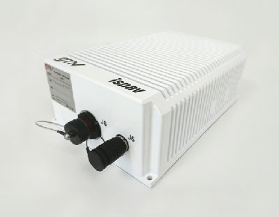
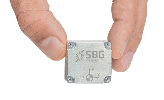
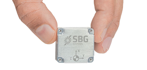
    SBG Systems is introducing the Pulse-40 inertial measurement unit (IMU), a tactical-grade IMU designed for high performance in harsh conditions, but miniaturized for applications where precision and robustness matter in all conditions.

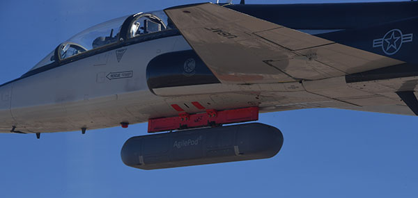
    Use cases include warfare systems, satellite communications, robotics, lidar devices, gimbals, cameras and inertial navigation systems (INS).

    The Pulse-40 IMU provides six-degrees-of-freedom. It integrates micro-electromechanical (MEMS) three-axes accelerometers and gyroscopes in a unique redundant design that allows the device size to shrink while pushing performance to its maximum.

    Photo: SBG Systems
    The Pulse-40 on a development board. (Photo: SBG Systems)

    Among the performance specifications, the Pulse-40 features excellent gyro and accelerometer bias instability of 0.8°/h and 6 µg respectively, enabling long dead-reckoning and maintaining excellent heading performance. With sensors featuring extremely low vibration rectification error (VRE), the Pulse-40 is able to sustain high vibration environments, up to 10 g root-mean-squared.

    An embedded continuous built-in-test ensures data reliability during operation, a key parameter for critical applications. The Pulse-40 requires no periodic maintenance. An intensive qualification process — including accelerated aging — guarantees that the sensor behavior is stable over time.

    Photo: SBG Systems
    Photo: SBG Systems

    Main Features

    • Size, weight and power (SWaP) design: 12 grams, 0.3W Power consumption
    • Ultra-low noise gyro (0.08°/√h) and excellent gyro bias instability (0.8°/h)
    • High-precision accelerometers (6 µg)
    • Low vibration rectification error: shocks and vibrations MIL-STD 810 qualified
    • High bandwidth (480Hz) and high data rate (2KHz)
    • Highly tested and calibrated from –40° C to 85° C
    • No export restrictions

    Research Result

    SBG Systems’ sensor calibration and validation tools, initially based on a single axis motion simulator with a temperature chamber, have evolved over the years and are now based on 100% automated, multi-axis motion simulators with temperature chambers. The high level of automation mitigates human-error risk and ensures that all the delivered products meet their specifications. Its  INS are the result of extensive research in signal processing, micro-electronics, calibration algorithms and sensor qualification, the company said.

    With very low gyro noise and bias instability, the navigation performance is maximized in GNSS-disturbed or -denied environments. The Pulse-40 is export license free and ITAR free.

  • Spanish Navy tests Seeker UAS in demanding exercise

    Spanish Navy tests Seeker UAS in demanding exercise

    The Seeker UAS proved itself a vital asset in a recent exercise for the Spanish Navy. The UAS, developed by GMV and Spanish technology company Aurea Avionics, was used for intelligence gathering through threat identification, tracking vehicles and other targets, and assessing terrain, routes and settlements.

    The Marine Infantry Brigade (BRIMAR), part of the Tercio de Armada de Infantería de Marina (Marine Infantry Protection Force), deployed the Seeker Dec. 9-13 at the San Gregorio national training center in Zaragoza during an exercise known as FTX-BRIMAR 21.

    In the demanding live-fire exercises, the BRIMAR troops were able to take full advantage of the Seeker’s autonomy and range to conduct operations from advantageous locations — even in adverse weather conditions, with surface winds exceeding 40 knots — and to arrange autonomous takeoffs and landings in conditions providing little to zero visibility, including night flights.

    Photo: GMV
    Photo: GMV

    Despite the complex environment, the Seeker UAS was able to deploy smoothly and enabled the BRIMAR to locate targets both day and night thanks to its dual payload, complete with both a thermal and visible light camera. This contributed to the success of the exercises.

    During the exercises, the Seeker UAS processed available data sources to supplement the video with information of use to all deployed troops, not just the system operators: the video and data generated was distributed in real time to the BRIMAR control station using VidStream, a secure, high-quality, latency-free video and data transmission system. This was done using the new RF-7800H-MP radios from L3Harris, which are natively integrated into VidStream. With this setup, the Seeker UAS was the only system to relay video from its ground position to the control station.

    Photo: GMV
    Photo: GMV

    The Seeker system was involved in the exercises under the RAPAZ program led by the Subdirectorate-General for Planning, Technology and Innovation, which reports to Spain’s Directorate General of Weapons and Material.

    The Seeker UAS is in the Class I Mini segment for defense. It has endurance of 90 minutes, a range of 15 km and a weight of 3.5 kg. Both the Spanish Navy and the Spanish Army received the first Seeker UAS units to reinforce the intelligence, surveillance and reconnaissance capabilities of the elite Marine Infantry Protection Force and the Spanish Army’s elite Almogávares VI Paratrooper Brigade.

    Photo: GMV
    Photo: GMV
  • Space Systems Command launches USSF-8 mission for US Space Force

    Space Systems Command launches USSF-8 mission for US Space Force

    Space Systems Command, together with United Launch Alliance and other mission partners, successfully placed the fifth and sixth Northrop Grumman-built Geosynchronous Space Situational Awareness Program (GSSAP)-5/-6 satellites into orbit for the U.S. Space Force, after an on-time launch aboard an Atlas V rocket from Space Launch Complex (SLC)-41 at Cape Canaveral Space Force Station, Florida, at 2 p.m. EST (11 a.m. PST).

    “The evolving threat to our space environment requires new levels of resiliency and survivability, autonomy and automation, and unprecedented levels of integration and networking,” said Lt. Gen. Michael A. Guetlein, commander of Space Systems Command. “Today’s successful launch will enhance our capabilities in space domain awareness and our space-based space domain awareness architecture. Congratulations to the USSF-8 integrated team and all mission partners on a successful launch.”

    The GSSAP-5/-6 satellites join a constellation supporting U.S. Space Command’s space surveillance operations as a dedicated Space Surveillance Network sensor.

    GSSAP also supports the Combined Force Space Component Command by collecting space domain awareness data, allowing for more accurate tracking and characterization of manmade orbiting objects. GSSAP is led by SSC’s Special Programs directorate.

    The National Security Space Launch (NSSL) mission launched aboard ULA’s Atlas V in the “511” configuration, which was comprised of a five-meter diameter payload fairing from RUAG Space, a single Graphite Epoxy Motor (GEM)-63 solid rocket booster from Northrop Grumman, and a single RL-10 engine from Aerojet Rocketdyne on the Centaur upper stage.

    SSC’s Launch Enterprise acquired the launch service through ULA and was responsible for successfully placing the GSSAP satellites on orbit.

    The NSSL program provides assured access for the United States’s critical warfighting space assets, and this launch vehicle has reliably placed valuable assets into their intended orbits repeatedly, adding to the NSSL program’s success record of 88 consecutive launches. The program supports a full range of government mission requirements for the nation’s defense and intelligence sectors.

    Space Systems Command is the U.S. Space Force field command responsible for rapidly identifying, prototyping and fielding resilient space capabilities for joint warfighters. SSC delivers sustainable joint space warfighting capabilities to defend the nation and its allies while disrupting adversaries in the contested space domain. SSC mission areas include launch acquisition and operations; space domain awareness; positioning, navigation and timing; missile warning; satellite communication; and cross-mission ground, command and control and data.

    A ULA Atlas V rocket carried the USSF-8 mission for the U.S. Space Force into orbit, (Photo: ULA)
    A ULA Atlas V rocket carried the USSF-8 mission for the U.S. Space Force into orbit, (Photo: ULA)
  • GMV begins production of navigation system for Spanish army

    GMV begins production of navigation system for Spanish army

    Photo: GMV
    Photo: GMV

    GMV will supply its advanced navigation and timing solution to the Spanish Army, providing positioning information on armored vehicles with or without GNSS signals.

    The 8×8 Dragón wheeled combat vehicle (WCV, or VCR in Spanish) will use GMV’s ISNAV system. GMV signed a contract with TESS Defence in August 2020 for €2.1 billion. The contract will equip 240 Dragóns with ISNAVs. GMV plans to produce the ISNAV units at its manufacturing facilities in Tres Cantos, which opened in 2019. The first units will be delivered in the fourth quarter of 2023.

    The ISNAV system was developed by GMV as part of the VCR 8×8 Technology Program. It meets the demanding requirements of the program and has successfully passed both the mission system integration tests, and the functional tests installed on several demonstration units.

    The ISNAV was designed to be modular equipment that can be adapted to various vehicle configurations, sensors and receivers. It includes the option of including Galileo PRS to provide advanced PNT (positioning, navigation and timing) capabilities, making it possible to determine the position of the vehicle in all kinds of scenarios, including scenarios without a GNSS signal.

    Photo: Spanish Ministry of Defence
    Photo: Spanish Ministry of Defence
  • US Army selects Orolia Defense & Security as winner in XTech Plugfest

    US Army selects Orolia Defense & Security as winner in XTech Plugfest

    Company prevails in military’s pursuit of CMOSS PNT solutions

    Recognized for its outstanding technology achievements and the potential for impact to the United States Army and Department of Defense (DOD), Orolia Defense & Security was selected by a panel of judges as a finalist during the 2021 xTech Plugfest competition.

    Hosted by PEO IEW&S, PM-PNT, the event allowed industry participants to demonstrate C5ISR/EW Modular Open Suite of Standards (CMOSS) capabilities via PNT cards, switch cards and chassis.

    The event took place at the Open Innovation Laboratory (OIL) on Aberdeen Proving Grounds, Maryland, Nov. 8-19, 2021.

    Photo: Orolia
    Photo: Orolia

    CMOSS prescribes criteria for integrators that reduce the size, weight, and power (SWaP) of C5ISR and EW systems while increasing their flexibility and adaptability by enabling the sharing of hardware and software components.

    Orolia submitted a CMOSS timing card and was formally recognized as a top five winner at OIL’s open house (with 200+ attendees) for demonstrating its capabilities and commitment to supporting the U.S. Army and DOD in pursuit of CMOSS PNT solutions.

    “I am extremely proud of our team for their efforts and sharp-wittedness in developing and presenting this technology at an accelerated level,” said Conrad Meyer, director of business development at Orolia Defense & Security. “We are honored to have taken part in this event and to be distinguished among many contenders.”

    Orolia’s prototype has a plug-and-play architecture powered by its FlexFusion engine, with additional capability for jamming and spoofing detection via its patented BroadShield software. It is designed for easy in-field upgradability.

    Orolia plans this year to release a commercially available, fully compliant CMOSS/SOSA PNT card for use in military air and ground-mounted systems.

  • Raytheon swarm enables one operator to guide 100+ drones

    Raytheon swarm enables one operator to guide 100+ drones

    Raytheon BBN-led team recently supported DARPA's fifth OFFSET program field exercise. (Photo: Raytheon)
    Raytheon BBN-led team recently supported DARPA’s fifth OFFSET program field exercise. (Photo: Raytheon)

    Raytheon Intelligence & Space, a Raytheon Technologies business, recently supported the fifth OFFensive Swarm-Enabled Tactics (OFFSET) DARPA program field exercise.

    Using integrated swarm technology developed by a Raytheon BBN-led team, a single operator successfully controlled a swarm — composed of 130 physical drone platforms and 30 simulated drone platforms — both indoors and outdoors in an urban setting. Raytheon BBN provides advanced technology research and development with a focus on national security priorities.

    During the exercise, the team used a combination of commercial off-the-shelf and custom-built hardware and software to deliver swarm autonomy. This enabled a single or small group of operators to direct and manage the activities of a large swarm of autonomous air and ground vehicles with minimal training.

    “Controlling a drone swarm changes the way an operator or group of operators think about the drones,” said Shane Clark, Raytheon BBN OFFSET principal investigator. “Takeaways from this exercise help inform us of the inflection points between utility and manageability.”

    Inexpensive Hardware

    A key element of the program is the use of inexpensive hardware. Without the powerful computing and sensing capabilities available in larger more expensive platforms, Raytheon BBN needed to create a broad library of simple tactic building blocks used to create plans to accomplish mission objectives.

    Raytheon BBN also designed and configured a scalable, modular and decentralized approach to manage a variety of current and future platforms and missions. Whenever possible, the drones collaborate actively to decide how to accomplish a specific mission most efficiently.

    “Our software is smart enough to assign drones with the right capabilities to the appropriate set of tasks,” Clark said. “For example, if the task is to surveil a building, multiple drones will be dispatched, with each surveilling portions of the building. The software considers each platform’s sensor capabilities, and tasks drones with downward-facing cameras to surveil the roof.”

    Once the drones are deployed, their collaboration allows them to understand what parts of a building have been explored and where the gaps are. They then autonomously select how to fill in those gaps.

    Virtual Reality Interface

    To tackle the complexities of human swarm interfaces, the Raytheon BBN team created a virtual reality interface in addition to traditional camera views. It takes feeds from all the swarm assets to create an interactive virtual view of the environment.

    “You can look behind the building to access a view of drone locations, for example, and use the virtual reality environment to test and see if your mission is viable,” Clark said. “We also developed a speech interface with the operationally deployed Tactical Assault Kit, or TAK, integration capability that enables the operator to act quickly while maintaining situational awareness over many systems simultaneously.”

    The Raytheon BBN-led team includes Smart Information Flow Technologies, or SIFT, and Oregon State University. The team is contracted by DARPA to demonstrate its swarm capabilities during Army Expeditionary Warrior Experiment 2022 taking place in February to March, and hosted by the Army Maneuver Battle Lab.

  • US Army selects TRX Systems to provide DAPS PNT system

    US Army selects TRX Systems to provide DAPS PNT system

    The TRX DAPS solution will allow warfighters to better target, move and communicate in operational environments where GPS is degraded or denied.

    TRX DAPS Dismounted A-PNT Device. (Photo: TRX Systems)
    TRX DAPS Dismounted A-PNT device. (Photo: TRX Systems)

    TRX Systems, developer of NEON GPS-denied location solutions, has been selected by the U.S. Army to provide a next-generation Dismounted Assured Positioning, Navigation and Timing (PNT) System (DAPS).

    The TRX DAPS solution employs a lightweight soldier-worn device that enables dismounted warfighters to successfully conduct operations when operating in GPS challenged, degraded or denied environments.

    Military equipment can be the subject of enemy electronic attacks, potentially resulting in a loss of location awareness that can put army missions at increased risk. The TRX DAPS solution alerts the users when their position isn’t reliable and then leverages multiple sensors and timing sources to provide the best soldier position possible within the GPS-degraded operational environment.

    The solution — designed to replace the Defense Advanced GPS Receiver (DAGR) — supports both a standalone configuration and integration with the Nett Warrior ensemble. It combines inputs from small, body-worn sensors and other sources to provide assured PNT while meeting the size, weight and power (SWaP) needs of dismounted soldiers already physically burdened with heavy equipment loads.

    TRX Systems has delivered GPS-denied location technology to thousands of military, public safety  and security users worldwide.

    “Maintaining assured PNT is paramount to the situational awareness of U.S. warfighters in the many conflict zones around the world,” said Carol Politi, president and CEO of TRX Systems. “When initial units are fielded in mid-2022, the TRX DAPS solution will deliver a balance of the highest possible level of integrated PNT capabilities with the smallest package that can be fielded for dismounted warfighters.”

  • Air Force PNT AgilePod achieves flight test objectives

    Air Force PNT AgilePod achieves flight test objectives

    News from the Air Force Research Laboratory

    The Air Force Research Laboratory’s complementary positioning, navigation and timing (PNT) AgilePod prototype achieved three important objectives in flight tests conducted at Edwards Air Force Base Nov. 1-10, 2021.

    PNT AgilePod helps develop advanced navigation technology independent of GPS, according to Maj. Andrew Cottle, Air Force Strategic Development Planning and Experimentation (SDPE) office. This technology provides reliable, resilient PNT navigation signals through alternative means, increasing mission effectiveness in scenarios where access to GPS is not guaranteed.

    The test team — representing a broad base of Air Force, Navy and vendor organizations — successfully executed eight sorties aboard a T-38C aircraft, which included:

    • the first test of the PNT AgilePod on a high-dynamic-range platform
    • the first test of fully remote interfacing and alt-PNT data transmission
    • the first demonstration of overland/overwater transition performance.

    He said the tests demonstrated the operational utility of a fused alt-PNT system incorporating multiple technologies within a single government-owned open-architecture prototype.

    A PNT AgilePod attached to a T-38C successfully demonstrated remote interfacing and alt-PNT data transmission. as well as performance over land and water. (Photo: USAF/2nd Lt. Bowen Lin, 586th Flight Test Squadron)
    A PNT AgilePod attached to a T-38C successfully demonstrated remote interfacing and alt-PNT data transmission, as well as performance over land and water. (Photo: USAF/2nd Lt. Bowen Lin, 586th Flight Test Squadron)

    AgilePods Designed for Flexibility

    AgilePods are comprised of a series of compartments and can be configured to meet a wide variety of mission requirements for many aircraft platforms. Experimenters can fill the spaces with plug-and-play sensors they need for a mission — high-definition video, electro-optical and infrared sensors, and devices with other capabilities — including PNT.

    The AgilePod has an open hardware architecture. For the complementary PNT prototype, it was combined with an open software architecture that allows a wide variety of alternative PNT technology to integrate and pass information. These capabilities enable rapid integration of sensor technologies through standardized software and hardware interfaces, allowing the pod to seamlessly integrate on platforms that leverage the standard architectures.

    In this way, one pod can perform hundreds of different mission sets with additional benefits of cost savings and increased sustainability, Cottle said.

    The project directly supports the AFRL PNT Enterprise and the Air Force PNT Cross-Functional Team as they work to ensure reliable navigation within GPS-contested operational scenarios critical to the success of future Air and Space Force missions.

    A PNT AgilePod attached to a T-38C successfully demonstrated remote interfacing and alt-PNT data transmission. as well as performance over land and water. (Photo: USAF/2nd Lt. Bowen Lin, 586th Flight Test Squadron)
    A PNT AgilePod attached to a T-38C successfully demonstrated remote interfacing and alt-PNT data transmission, as well as performance over land and water. (Photo: USAF/2nd Lt. Bowen Lin, 586th Flight Test Squadron)
  • BAE Systems awarded a $316M contract to deliver military GPS modules

    BAE Systems awarded a $316M contract to deliver military GPS modules

    Image: BAE Systems
    Image: BAE Systems

    The U.S. Defense Logistics Agency has executed a $316 million contract option for BAE Systems’ advanced M-code GPS modules, raising the contract funding to $641 million.

    The modules provide dependable positioning, navigation, and timing for ground troops, vehicles, aircraft and precision munitions. The contract will ensure the availability of Common GPS Modules (CGM) for advanced military GPS receivers with anti-jamming and anti-spoofing capabilities that enable operation in contested environments.

    Under the contract option executed in November, BAE Systems will manufacture CGMs for future ground, airborne and weapon GPS receivers for the U.S. Department of Defense (DoD) and its allies. The award builds on a May $325 million contract and enables BAE Systems to continue to meet domestic and international demand for Military GPS User Equipment (MGUE) Increment 1 M-Code modules in GPS receivers through the end of the decade.

    “Military operations require assured positioning, navigation and timing, and our customers are shifting to M-code to harden their GPS receivers against jamming and spoofing,” said Frank Zane, Navigation and Sensor Systems business development director at BAE Systems. “We’re ready to meet this need today with secure, reliable M-code GPS solutions, and we’re developing the next-generation of solutions to stay ahead of the threat.”

    BAE Systems is delivering two advanced M-code GPS receivers: the Miniature Precision Lightweight GPS Receiver Engine – M-Code and the NavStrike-M GPS receiver.

    Deliveries of the ultra-small MicroGRAM-M are expected in 2022, and deliveries of the Strategic Anti-jam Beamforming Receiver – M-Code are expected in 2024.

  • Safran to acquire resilient PNT company Orolia

    Safran to acquire resilient PNT company Orolia

    Orolia logo

    Safran has entered into exclusive discussions to acquire Orolia from Eurazeo alongside the founders and management. Orolia is a world leader in resilient positioning, navigation and timing (PNT) solutions that improve the reliability, performance and safety of critical civilian, military and space operations, including in harsh or altered GNSS environments.

    Safran is an international high-technology group, operating in the aviation (propulsion, equipment and interiors), defense and space markets. Headquartered in Paris, France, Safran has a global presence, with 76,000 employees and sales of 16.5 billion euros in 2020.

    Orolia has a broad portfolio of technologies across the resilient PNT value-chain with full system capabilities, and is a provider of PNT equipment, simulation and test solutions. Orolia is also providing emergency locator beacons for commercial aviation and military applications.

    The acquisition “represents a unique opportunity for Safran and Orolia to extend their resilient PNT solutions, through their remarkable complementarities,” Safran stated in a press release. “With this addition, Safran will be able to build a world-leading position in all aspects of PNT, inertial navigation, time and GNSS receivers and simulators, covering aerospace, governmental and high integrity applications.”

    Safran intends to accelerate the development of Orolia under the leadership of CEO Jean-Yves Courtois, and in full collaboration with its teams. “The combination of Orolia and Safran will create a PNT world leader with capabilities that will be unsurpassed in depth and breadth,” Courtois said. “Our perfect complementarity in terms of technology expertise, market presence and geographic footprint will allow us to push further resilient PNT to the next level and to offer our government, aerospace and commercial customers the most advanced solutions they need for their critical operations. Orolia will contribute especially through its world-leading positions in timing, GNSS simulation and emergency location technologies, and through its strong presence in the U.S. market. We are looking forward to working with our new Safran colleagues to advance our common vision.”

    Orolia is expected to generate revenues of more than EUR 100 million in 2021 and has approximately 435 employees with facilities in France, the United States, Switzerland, Spain and Canada.

    The terms of the deal were not disclosed. The transaction is subject to the usual regulatory approvals. Orolia will be consolidated within Safran’s Equipment & Defense division upon closing, expected around mid-2022.

  • Spectranetix announces high-precision A-PNT card for Army

    Spectranetix announces high-precision A-PNT card for Army

    Photo: Spectranetix
    Photo: Spectranetix

    Spectranetix Inc., a Pacific Defense company, has announced the SX-124 ruggedized 3U OpenVPX high-performance positioning, navigation and timing (PNT) card.

    With an ability to provide timing and positioning information in a GPS-denied environment through sensor fusion, the SX‑124 switch is designed for highly integrated systems with a requirement for the U.S. Army’s C5ISR Modular Open Suite of Standards (CMOSS) and alignment with the Open Group Sensor Open Systems Architecture (SOSA) technical standard.

    The SX-124 can accept external sources or use its onboard GNSS receivers as reference inputs for timing and positioning data. The positioning data can be fused with internal and external inertial measurement units (IMUs). It distributes 11 100-MHz outputs and 11 1PPS outputs in a phase coherent manner.

    The SX-124 provides timing and position holdover from an internal chip-scale atomic clock (CSAC) and IMU. A built-in time-of-day clock provides accurate network time stamps on system startup without GPS availability.

    The SX-124 also provides enhanced location information and can be connected to an external IMU as well as a controlled reception pattern antenna (CPRA).

    The SX-124 supports the standard VICTORY shared PNT services from a built-in GNSS timing receiver with an optional built-in M-code GB-GRAM receiver, CSAC and barometer to provide altitude information.

    With the option for expansion to support over-the-air rekeying (OTAR), external fiber-optic gyroscope (FOG), alternative navigation (ALTNAV), and additional GNSS systems such as Galileo, the SX-124 supports the defense community’s need for a high-performance assured PNT (A-PNT) solution in the 3U VPX form factor and aligned to the latest open set of standards.

    “Reliable situational awareness and cooperative, networked maneuvers demand assured PNT capability,” said Daniel Kilfoyle, CTO of Pacific Defense. “Our A-PNT solution embraces the pntOS open sensor-fusion framework and supports multiple sensor connections including GNSS receiver, GB-GRAM, IMU, FOG, CRPA and a two-channel software-defined RF receiver for added flexibility. Combined with exquisite timing and frequency performance and CMOSS alignment, this PNT card is yet another example of our commitment to CMOSS and SOSA.”

    The SX-124 card is on track for production release early next year.

  • Analog Devices honored with Electronics Industry 2021 Awards

    Analog Devices, Inc. (ADI) recently received four Electronics Industry 2021 Awards presented by Datateam Business Media. The awards honor the best professionals, products, projects, and companies across the electronics sector. ADI received awards in the following categories: environmental leadership, excellence in innovation  (for the ADAR3000 beam forming integrated circuit), aerospace/military/defense product of the year, and embedded solution product of the year (for the MAX78000 artificial intelligence microcontroller). It also received the “Highly Commended” distinction in the Internet of Things product of the year category.

    Established in 2018, the Electronics Industry Awards annually recognize the best people, products, and business practices at the forefront of innovation. The awards winners are determined by a 50/50 weighted decision from an industry vote and a panel of expert judges to ensure the winners are selected for technical expertise and outstanding reputations.