Category: Defense

  • Southwest Antennas releases rugged GPS/GLONASS antenna

    Southwest Antennas releases rugged GPS/GLONASS antenna

    Southwest Antennas has introduced a high-performance GPS and GLONASS active L1/L2 patch antenna for high-accuracy location service, timing and navigation applications.

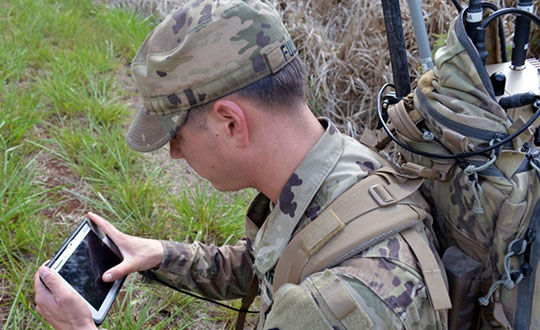
    Part #1065-042 covers both the L1 and L2 bands, supporting military, commercial and industrial applications. For military users, the antenna supports the GPS P/Y code with +/-20-MHz bandwidth, allowing for increased accuracy, jam resistance and encryption for authorized military applications.

    Photo: Southwest Antennas
    Photo: Southwest Antennas

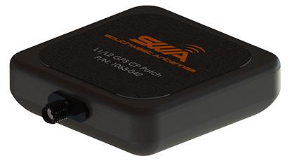
    The antenna’s built-in low-noise amplifier (LNA) and filters give it a total system active gain of +28 dB and out-of-band rejection of >50 dB (+50 MHz / -35 MHz of L1, +35 MHz / -45 MHz of L2). The specifications allow the antenna to operate in contested and congested radio frequency (RF) environments.

    “Our goal is to empower radio operators who require high-accuracy GNSS solutions with more choices for deployment and mounting,” said Benjamin Culver, president and co-owner of Southwest Antennas. “Adding onto our existing line of GPS antennas and gooseneck mounting options, users now have more freedom of choice in antenna placement to help overcome reception issues in challenging environments.”

    The low-profile radome allows the antenna to be easily tucked into pockets or modular lightweight load-carrying equipment (MOLLE) pouches and mounted on body armor, vests, rucksacks or other tactical gear. The custom black chrome SMA(f) RF connector ensures the antenna is waterproof, while allowing users to fully customize antenna placement on their gear and select their own cable type and length to suit their preference for mounting location away from their receiver.

    For additional flexibility in mounting locations, part #1065-042 features a magnetic mount integrated flush into the antenna’s radome, allowing it to be secured and removed quickly from any ferromagnetic surface. This extends the antenna’s operational capabilities through the ability to remotely locate the antenna away from the attached radio system to enhance satellite acquisition speed and signal strength when operating in environments with poor sky views.

    Applications include:

    • SAASM GPS, GLONASS, GNSS receivers, and other precision navigation receivers
    • Manpack and handheld radios, dismounted soldier-level communications
    • Small form-factor radios
    • Low-profile vehicle mounts and unmanned ground vehicles
    • Unattended/intelligent munitions systems
    • Aviators, combat search-and-rescue radios
    • IED recognition and destruction jamming systems
    • Law enforcement and first responders
    • Precision surveying receivers
    • Asset tracking
    • Precision timing applications
    • LBS and M2M applications
    • Oil and gas industries
  • KVH offers TACNAV 3D with photonic integrated chip technology

    KVH offers TACNAV 3D with photonic integrated chip technology

    KVH’s widely fielded tactical navigation system now upgraded with its patented PIC technology

    Photo: KVH Industries
    Photo: KVH Industries

    KVH Industries’ TACNAV 3D tactical navigation system is now available with the P-1775 inertial measurement unit (IMU) featuring KVH’s new photonic integrated chip (PIC) technology.

    KVH has been developing and testing the PIC technology for more than three years and is continuing to roll the technology into existing product lines.

    KVH’s PIC technology features an integrated planar optical chip that replaces individual fiber optic components to simplify production while maintaining or improving accuracy and performance. KVH’s IMUs with PIC technology are designed to deliver improved bias stability and 20 times higher accuracy than other micro-electromechanical systems (MEMS) IMUs.

    The fiber-optic gyro (FOG)-based TACNAV 3D tactical navigation system provides an assured positioning, navigation and timing (A-PNT) solution with an embedded GNSS and optional chip-scale atomic clock (CSAC). TACNAV 3D’s modular tactical design enables it to function as a standalone inertial navigation solution and as the core of an A-PNT-capable multi-functional battlefield management system.

    “We are pleased to incorporate our newest technology into the TACNAV 3D,” said Dan Conway, executive vice president of KVH’s inertial navigation group. “We are committed to ensuring that this battle-proven system provides the precise navigation that is vital to mission success and addresses the military demand for assured positioning, navigation, and timing (A-PNT) solutions.”

    KVH’s TACNAV solutions are being used in vehicles that operate in demanding environments, from battle tanks and M-ATVs, to armored vehicles, reconnaissance and combat support vehicles.

    Defense forces using TACNAV systems include the U.S. Army and Marine Corps, as well as many allied customers including Australia, Botswana, Brazil, Canada, Egypt, France, Germany, Great Britain, Italy, Malaysia, New Zealand, Poland, Romania, Saudi Arabia, Singapore, South Korea, Spain, Sweden, Switzerland, Taiwan and Turkey.

  • Boeing Loyal Wingman uncrewed aircraft completes first flight

    Boeing Loyal Wingman uncrewed aircraft completes first flight

    Photo: Boeing Australia
    Photo: Boeing Australia

    Successful test progresses Royal Australian Air Force’s teaming aircraft program

    Boeing Australia and the Royal Australian Air Force (RAAF) successfully completed the first test flight of the Loyal Wingman uncrewed aircraft on Feb. 27.

    The flight of the first military aircraft to be designed and manufactured in Australia in more than 50 years flew under the supervision of a Boeing test pilot monitoring the aircraft from a ground control station at the Woomera Range Complex in the South Australian outback.

    “The Loyal Wingman’s first flight is a major step in this long-term, significant project for the Air Force and Boeing Australia, and we’re thrilled to be a part of the successful test,” said Air Vice-Marshal Cath Roberts, RAAF head of Air Force Capability. “The Loyal Wingman project is a pathfinder for the integration of autonomous systems and artificial intelligence to create smart human-machine teams. “Through this project we are learning how to integrate these new capabilities to complement and extend air combat and other missions,” she said.

    Following a series of taxi tests validating ground handling, navigation and control, and pilot interface, the aircraft completed a successful takeoff under its own power before flying a predetermined route at different speeds and altitudes to verify flight functionality and demonstrate the performance of the Airpower Teaming System design.

    “Boeing and Australia are pioneering fully integrated combat operations by crewed and uncrewed aircraft,” said Boeing Defense, Space & Security President and CEO Leanne Caret. “We’re honored to be opening this part of aviation’s future with the Royal Australian Air Force, and we look forward to showing others how they also could benefit from our loyal wingman capabilities.”

    With support from more than 35 Australian industry teams and leveraging Boeing’s innovative processes, including model-based engineering techniques, such as a digital twin to digitally flight-test missions, the team was able to manufacture the aircraft from design to flight in three years.

    This first Loyal Wingman aircraft is serving as the foundation for the Boeing Airpower Teaming System being developed for various global defense customers. The aircraft will fly alongside other platforms, using artificial intelligence to team with existing crewed and uncrewed assets to complement mission capabilities.

    Additional Loyal Wingman aircraft are under development, with plans for teaming flights scheduled for later this year.

  • PNT Integrity Library published to help protect critical infrastructure

    PNT Integrity Library published to help protect critical infrastructure

    Logo CISAThe U.S. Department of Homeland Security (DHS) Science and Technology Directorate (S&T) has published the Positioning, Navigation, and Timing (PNT) Integrity Library and Epsilon Algorithm Suite to protect against GNSS spoofing, or deceiving a GPS device through false signals. These resources advance the design of PNT systems and increase resilience of critical infrastructure to PNT disruptions, according to the Coast Guard Navigation Center.

    PNT services, such as GPS, are a national critical function that enable many applications within the critical infrastructure sectors. However, “The increasing reliance on GPS for military, civil and commercial applications makes the system vulnerable,” according to Space Policy Directive-7 (SPD-7), issued Jan. 15. “GPS users must plan for potential signal loss and take reasonable steps to verify or authenticate the integrity of the received GPS data and ranging signal, especially in applications where even small degradations can result in loss of life.”

    The PNT Integrity Library and Epsilon Algorithm Suite address this issue by providing users a method to verify the integrity of the received GPS data. “We are excited to release these resources to the PNT community to improve resiliency against potential GPS signal loss,” said DHS S&T PNT Program Manager Brannan Villee.

    “Since GPS signals can be jammed or spoofed, critical infrastructure systems should not be designed with the assumption that GPS data will always be available or will always be accurate,” said Jim Platt, chief of Strategic Defense Initiatives at the Cybersecurity and Information Security Agency (CISA) National Risk Management Center. “Application of these tools will provide increased security against GPS disruptions. However, DHS also recommends a holistic defense strategy that considers the integrity of the PNT data from its reception through its use in the supported system.”

    The PNT Integrity Library and Epsilon Algorithm Suite are open source and available free of charge. To view more details, visit the DHS S&T PNT Program.

  • Hexagon partners with Navantia for Spanish Navy combat system

    Hexagon partners with Navantia for Spanish Navy combat system

    Navantia has selected Luciad — Hexagon’s platform for building advanced location intelligence and real-time situational awareness applications — to equip the combat system of five future F-110 frigates for the Spanish Navy.

    The agreement will also cover corresponding tests, validations and simulation environments, according to Hexagon’s Geospatial division.

    Navantia and the Spanish Ministry of Defense signed a contract for the construction of the F-110 frigates in April 2019.

    Starting in 2016, Hexagon’s Luciad was subjected to the strictest technical benchmarks by Navantia and the Spanish Navy, along with other comparable geospatial technologies on the market. Luciad surpassed the competition to secure the partnership.

    Since then, Navantia has developed initial versions of the combat system, which integrates sensors, nautical cartography, AIS tracks and more.

    “We are proud to support Navantia and the Spanish Navy,” said Jose Luis Peinado, vice president of Hexagon’s Geospatial division. “This partnership represents another step of our expansion in the defense market and is recognition of Hexagon as a leader in geospatial software for mission-critical environments, where robustness and high performance are key.”

    As part of the new partnership, Navantia will join a growing list of systems integrators and defense ministries, including NATO, that have chosen Luciad as the engine for command and control, air defense, border surveillance, combat systems, intelligence and more.

    Luciad enables intuitive and interactive map-centric views for aviation, smart cities and defense. It can connect to any database and more than 200 data formats, including real-time data with domain-specific standards. Users can guarantee the highest accuracy, as well as visualize situations in 2D and 3D with rich and flexible styling options.


    Feature image: Screenshot: Navantia

  • BAE Systems to develop advanced GPS chips for warfighters

    BAE Systems to develop advanced GPS chips for warfighters

    Logo: BAE SystemsBAE Systems has received a $247 million contract from the U.S. Space Force’s Space and Missile Systems Center to design and manufacture an advanced military GPS receiver and next-generation semiconductor.

    The technology will provide positioning, navigation, and timing (PNT) capabilities to warfighters so they can execute missions in challenging electromagnetic environments.

    MGUE Increment 2

    The contract is related to November’s U.S. Department of Defense contract for M-Code military GPS technology.

    The Military GPS User Equipment (MGUE) Increment 2 Miniature Serial Interface program will provide improved capabilities for size-constrained and power-constrained military GPS applications, including precision-guided munitions and battery-powered handheld devices.

    The program will focus on the certification of an advanced application-specific integrated circuit (ASIC) and the development of an ultra-small, low-power GPS module.

    Both products will work with the next-generation military M-code signal technology, which provides reliable GPS data with anti-jamming and anti-spoofing capabilities to protect against electronic warfare threats.

    “This program enables us to further develop our core M-code technology to deliver high-performance, next-generation GPS capabilities,” said Greg Wild, director of Navigation and Sensor Systems at BAE Systems. “Our M-code receiver and next-gen ASIC will enable secure and reliable military GPS capabilities in a broader range of platforms.”

    BAE Systems’ Precision Strike business has 45 years of military GPS experience and more than 1.5 million GPS devices on over 280 platforms around the world. The company is currently producing M-code GPS receivers in multiple form factors, including a low power, small form factor M-code solution.

    Additional prototypes are in development for ground, weapons and airborne mission applications, and the company’s M-code GPS products are available to U.S. allies via foreign military sales.

    Work on the program will be conducted at the company’s facility in Cedar Rapids, Iowa.


    Feature image: An Airman with the 374th Security Forces Squadron uses a Defense Advanced GPS Receiver (DAGR) to track the team’s current during a 2018 field training exercise at Camp Fuji, Japan. (Photo: Senior Airman Matthew Gilmore/U.S. Air Force)

  • GMV takes part in European GEODE military project

    GMV takes part in European GEODE military project

    Photo:Spain-based GMV is taking responsibility for integration of the GNSS/PRS receiver system for the European Union’s (EU’s) GEODE project.

    GEODE (GalilEO for EU DEfence) is the biggest Galileo application development project ever launched and a crucial and decisive step towards the development of the Galileo Galileo PRS (PRS) military user segment. GEODE is and one of the most ambitious defense cooperation projects launched under the umbrella of the European Commission’s European Defence Industrial Development Programme (EDIDP).

    Co-financed by Belgium, Germany, Italy, France and Spain, GEODE is supported by the EU with a grant of about 44 million Euros.

    GMV, part of the Spanish industrial team, will develop the GNSS/PRS receiver’s signal-processing, navigation and timing functions. GMV also participated in the Feb. 8 GEODE kick-off meeting.

    GEODE aims to boost the EU industry’s competitiveness in the highly strategic domain of military positioning, navigation, timing and synchronization (PNT) and to endow EU military forces with Galileo PRS capacity. The project will be implemented by a consortium of 30 undertakings from 14 EU countries.

    The Spanish industrial team made up by GMV, Indra and Tecnobit, takes on first-level responsibility for the complete development of the solution for naval military platforms (GNSS/PRS receiver with security module and CRPA antenna). GMV is responsible for the integration of the GNSS/PRS receiver system and, in particular, for the development of all the receiver’s signal-processing, navigation and timing functions.

    GEODE will provide the EU Industry with an even playing field in the Defense PNT market, where military GPS’s essentialness at the moment ensures U.S. industry’s supremacy. It will also reinforce EU military capability and autonomy and maximize the benefits of the Galileo program by promoting take-up of its crucial PRS service.

    Following an initial specification and standardization phase, the project will then prototype, test and qualify all the elements of a complete PRS solution:

    • PRS security modules
    • PRS receivers
    • GPS/Galileo PRS compatible controlled radiation pattern antennas (CRPAs)
    • A common and standardized test environment.

    A PRS solution for spacecraft will be also designed and prototyped. Complementarily, a PRS infrastructure will be developed to ensure the availability of the security assets necessary for operational testing.

    Military operational field testing will be organized on military naval and land platforms, RPAS, and a timing and synchronization system.

    GEODE will boost the EU industry competitiveness in the highly strategic domain of military positioning, timing and synchronization, it will foster the equipment of EU Member States’ military forces with the Galileo PRS capability, essential to reinforce their interoperability and autonomy. It also will facilitate access to complex security certified technologies and make them affordable through means of standardization and by creating the necessary critical mass.

  • Raytheon Intelligence & Space delivers 3,000th GPS receiver

    Raytheon Intelligence & Space delivers 3,000th GPS receiver

    Raytheon Intelligence & Space, a Raytheon Technologies business, delivered its 3,000th MAGR 2000-S24 GPS system to the U.S. Air Force. The MAGR2K is a secure, resilient GPS receiver that allows the warfighter to navigate the battlespace with protection against interference and jamming.

    The MAGR2K is an upgrade to the legacy miniaturized airborne GPS receivers and is in service aboard 20 types of fixed-wing and rotary-wing platforms from Department of Defense and Foreign Military Sales customers.

    “In the battlespace, disruptions to navigation are not an option,” said Eric Ditmars, vice president of Secure Sensor Solutions at RI&S. “Our MAGR2K GPS receivers enhance GPS acquisition and performance ensuring military forces reliable and assured GPS data they can act on. Delivery of the 3,000th unit is a significant milestone for our team.”

    Raytheon Intelligence & Space continues to upgrade the MAGR2K technology to stay current with the evolving battlespace. Development is underway for the MAGR-2K-M, which uses the company’s M-code technology.

    The first production readiness units are undergoing platform integration on the U.S. Air Force’s B-2 platform.

    B-2 Spirit multi-role bomber capable of delivering both conventional and nuclear munitions. In December 2017, the Air Force completed a series of successful flight tests of M-code GPS using a Raytheon Company receiver on board a B-2 Spirit at Edwards Air Force Base, California. (Photo: U.S. Air Force/Bobby Garcia)
    B-2 Spirit multi-role bomber capable of delivering both conventional and nuclear munitions. In December 2017, the Air Force completed a series of successful flight tests of M-code GPS using a Raytheon Company receiver on board a B-2 Spirit at Edwards Air Force Base, California. (Photo: U.S. Air Force/Bobby Garcia)
  • DSI to host 2021 Assured PNT Summit in April

    Logo: Defense Strategies Institute

    The Defense Strategies Institute’s (DSI) Assured Positioning, Navigation & Timing (PNT) Summit will take place April 14-15 at the Mary M. Gates Learning Center in Alexandria, Virginia.

    According to DSI, the event will bring together members of the military services, Department of Defense (DoD), federal government, industry and academia in a “town hall” style forum to discuss how important GPS and space-based PNT systems are to the overall resilience of the warfighter, as well as critical infrastructure across the United States and abroad.

    The 2021 Assured PNT Summit also will offer senior-level insight into how the U.S. military has been a leader in integrating PNT into its everyday operations and how such capabilities have become vital to the military’s ability to shape the global arena, deter aggression, and fight and win wars.

    Confirmed speakers for this year’s event include William Nelson, SES, director, APNT CFT, Army Futures Command; Brig. Gen. Heather L. Pringle, USAF, commander, Air Force Research Laboratory; Anthony C. Smith, SES, director, C3I, DoD CIO; Richard De Fatta, SES, director, U.S. Army Space & Missile Defense Center of Excellence; Cordell “Del” DeLaPena, SES, program executive officer for Space Production Space & Missile Systems Center, USAF; Harold W. Martin III, SES, director, National Coordination Office for Space-Based Positioning, Navigation and Timing; and Col. Jason Joose, USA, chief of staff/APNT signature effort lead, Army Futures Command.

    A number of topics will be covered at the 2021 Assured PNT Summit, including:

    • Leading current DoD initiatives toward integrating new PNT capabilities to help the Warfighter remain resilient in a dynamic threat environment;
    • Synchronizing PNT, navigation warfare and space capability development efforts across the Army to help reduce key capability gaps;
    • Delivering resilient, affordable and sustainable space capabilities such as modernized GPS to enhance warfighter superiority;
    • Providing alternate PNT for potential GPS-denied environments;
    • Accelerating the implementation of cutting-edge Air Force research projects such as NTS-3 GPS Satellite to provide the most value to the warfighter;
    • Developing critical PNT-related products to enable a Soldier’s PNT capabilities in all warfighting domains;
    • Overseeing the collection of GPS-related information from multiple federal agencies in an effort to improve and maintain space-based PNT capabilities;
    • Advancing efforts to provide GPS protection for all naval air platforms; and
    • Detailing the Department of Homeland Security plan to test the vulnerabilities of critical infrastructure systems, networks and assets if PNT services were to be disrupted or manipulated.

    Register for the event here.

  • GEODE begins work on military user equipment for Galileo

    GEODE begins work on military user equipment for Galileo

    A crucial step toward the development of the Galileo Public Regulated Service (PRS) military user segment took place Monday, Feb. 8, with the kick-off meeting in Brussels of the GEODE (GalilEO for EU DEfence) project, according to a press release from FDC.

    GEODE is the biggest Galileo application development project ever launched.

    Sponsored by Belgium, Germany, Italy, France and Spain — contributions should exceed 82.7 million euros — GEODE is supported by the EU with a grant of about 44 million euros. The ambitious defence-cooperation project is under the umbrella of the European Defence Industrial Development Programme (EDIDP) of the European Commission.

    GEODE will establish the framework for developing the Galileo PRS user segment for defense applications. At kick-off, the project involved 30 companies and organizations from 14 EU Member States: Belgium, Czech Republic, Estonia, Finland, France, Germany, Greece, Italy, the Netherlands, Poland, Portugal, Spain, Sweden and Romania.

    The GEODE Roadmap

    National defense organizations — in close cooperation with industry — have defined a roadmap for the Galileo PRS military user segment development, beginning with a specification and standardization phase. GEODE will prototype, test and qualify

    • seven PRS security modules developed from various technologies
    • nine PRS receivers (including two server-based variants)
    • four GPS/Galileo PRS-compatible anti-jamming controlled radiation pattern antennas (CRPA).

    A common and standardized test environment will be developed as well as a PRS infrastructure to ensure the availability of the security assets for operational testing.

    Finally, military operational field testing will be organized on military platforms (naval, land and drones) and timing and synchronization systems in (at least) Belgium, Czech Republic, France, Germany, Greece and Romania.

    A PRS solution for spacecraft will also be designed and prototyped.

    Beyond paving the way for the equipment of EU Member States defense forces with Galileo PRS, the military user segment that is developed, tested and certified under GEODE is planned to be available for export to other countries that have the necessary PRS security agreements with the EU.

    The GEODE project will be completed in 2026.

    Plans are for GEODE to

    • boost EU competitiveness in the highly strategic domain of military positioning, timing and synchronization.
    • foster the equipment of EU Member States’ military forces with Galileo PRS capability, essential to reinforce their interoperability and autonomy.
    • facilitate access to complex security-certified technologies and make them affordable through means of standardization and by creating the necessary critical mass.

    In brief, the project will bolster EU Member States’ military capability, create business opportunities for the EU industry in the field of military application of satellite navigation, and maximize the benefits of the Galileo programme by energizing the adoption of its PRS service in all EU Member States and beyond.

    Background on GEODE

    This project has received funding from the European Defence Industrial Development Programme (EDIDP) under grant agreement No 039.

    The GEODE industrial consortium is led by FDC and comprises the major industry players of the field: Airbus Defence and Space, Antwerp Space, Cy4gate, Diehl Defence, Elettronica, Fraunhofer Institute for Integrated Circuits IIS, GMV Aerospace and Defense, Indra Sistemas, Safran Electronics and Defense, Leonardo, Siemens Aktiengesellshaft, Orolia, Tecnobit, Telespazio, Thales Alenia Space Italia, Thales AVS France, Thales SIX GTS France, accompanied with 12 other EU companies acting as subcontractors (c.f. picture hereafter).

    The GEODE project is developed in the context of the European Radio-navigation Solution (EURAS) project of the Permanent Structure Cooperation (PESCO). The EURAS project aims at promoting the development of EU military positioning, navigation and timing) capabilities and future cooperation taking advantage of Galileo and the PRS.


    Feature photo: U.S. Army

  • M-code receivers start to roll out

    Military receivers key to Orolia’s PNT Solutions

    Orolia logoOrolia, through its Orolia Defense & Security business, announced in November 2020 the launch of M-code military GPS receivers in its line of positioning, navigation and timing (PNT) solutions.

    The line includes M-code-enabled mobile mission timing and synchronization platforms, such as the SecureSync IDM resilient time and frequency reference solution, the first time server approved by the Defense Information Systems Agency (DISA), and the Versa mobile PNT platform to meet rugged size, weight, power and cost (SWaP-C) requirements.

    M-code is a military signal used in the L1 and L2 GPS bands. It is required by congressional mandate for U.S. Department of Defense (DOD) military operations.

    M-code is designed to enhance PNT capabilities and improved resistance to existing and emerging threats to GPS, such as jamming and spoofing. Operational benefits of M-code include:

    • a higher power signal that offers improved resistance to jamming and interference
    • advanced security features to prevent unauthorized access or exploitation
    • improved message formats and signal modulation techniques for faster and more accurate performance.

    Orolia has long supported the DOD’s need for selective availability anti-spoofing module (SAASM)-enabled PNT equipment, explained Hironori Sasaki, president of Orolia Defense & Security. “This announcement emphasizes our move toward M-code and the availability of M-code in our products,” Sasaki said. “Our focus has always been on staying in sync with the DOD and providing the latest and greatest technologies.”
    Orolia now supports M-code in all its user products and offers two capabilities: simulation and M-code-enabled end-user devices. “They will each have a different approval process for export,” Sasaki said. “We follow DOD guidance on getting that capability out there.”

    SecureSync, which is SAASM-enabled, has been deployed with DOD for many years, so Orolia has “a very good install base” of these devices, according to Sasaki. “We are providing a very easy and seamless upgrade path to go from SAASM to M-code in that platform.” The company’s Versa platform consists of the VersaSync and the VersaPNT, both small form-factor PNT devices designed for rugged application in military vehicles or military aircraft.

    DOD has given Orolia approval to advertise the fact that it has these capabilities in its products. “We are expecting shipments to start in early 2021,” said Sasaki. “So, we are well on our way in development, implementation and productization.”

    “We have been focusing on providing products that have a modular architecture, both in software and hardware,” Sasaki added. “We are embracing this approach of open architecture and continue to support the DOD in providing different layers of sensing and PNT protection in a way that can be incorporated into future DOD systems.

    “We have already demonstrated our ability to deliver PNT solutions in various form factors, so I think we are in a good position to continue pushing forward with that open architecture approach,” Sasaki said.

  • DARPA-funded inertial sensors from Honeywell promise greater accuracy

    DARPA-funded inertial sensors from Honeywell promise greater accuracy

    Findings show accuracy of new sensors is improved by greater than an order of magnitude over current offerings.

    Honeywell, with funding from the U.S. Defense Advanced Research Projects Agency (DARPA), is creating the next generation of inertial sensor technology that will one day be used in both commercial and defense navigation applications.

    The HG1930 IMU. (Photo: Honeywell)
    The HG1930 IMU. (Photo: Honeywell)

    Findings gathered in Honeywell labs have shown the new sensors to be greater than an order of magnitude more accurate than Honeywell’s HG1930 inertial measurement unit (IMU) product, a tactical-grade product with more than 150,000 units currently in use.

    An IMU uses gyroscopes, accelerometers and electronics to give precise rotation and acceleration data to enable a vehicle system to calculate where it is, what direction it is going and at what speed, even when GPS signals aren’t available.

    There are various types of IMUs on the market, and some — like the next-generation version currently under development — use sensors based on micro-electromechanical systems (MEMS) technology to precisely measure motion.

    “Typically, MEMS inertial sensors have been on the lower end of the performance scale, but this latest milestone shows we are changing that paradigm,” said Jenni Strabley, director of offering management for Inertial Sensors, Honeywell Aerospace. “With this next-generation MEMS technology, we’re increasing performance without having to significantly change the size or weight of the IMU. This is a game-changer for the navigation industry, where customers need highly accurate solutions but cannot afford to compromise on weight or size.”

    Over the past few years, Honeywell has been working with DARPA to develop the next generation of high-precision navigation-grade IMU technology, under the Precise Robust Inertial Guidance for Munitions: Thermally Stabilized Inertial Guidance for Munitions program.

    The new MEMS sensors will use different sensor designs and electronics to enable higher performance. They will serve a broad range of applications in autonomous land and air vehicles for both military and commercial customers, including future urban air mobility aircraft.

    “Now that we have demonstrated that MEMS is capable of reaching these incredibly precise performance levels, it is the perfect time to start talking with potential users about how this technology could help their applications,” Strabley said. “We believe this new technology will have a variety of applications, such as onboard future vehicles that will fly in urban environments where lightweight, extremely precise navigation is critical to safer operations. Additionally, there are other applications that haven’t been invented yet but may be enabled by these types of technology innovations.”

    Commercial sales of an IMU containing these next-generation sensors are still several years away, but one of the first products using this new technology is expected to be more than 50 times more accurate while roughly the same size as Honeywell’s IMU.

    Honeywell has long been a pioneer in MEMS-based IMUs, including the HG1930. Honeywell’s lineage in navigation dates to the 1920s and since then Honeywell has developed and manufactured high-performance navigation solutions found on many aircraft and other vehicles worldwide.