Category: Defense

  • UrsaNav trials eLoran as GNSS backup with ADVA grandmaster clock

    UrsaNav trials eLoran as GNSS backup with ADVA grandmaster clock

    Successful eLoran field trial using ADVA’s OSA 5420 Series demonstrates same accuracy and stability as GPS with much-improved resilience

    UrsaNav and ADVA have conducted an enhanced long-range navigation (eLoran) field trial using UrsaNav’s eLoran receiver and ADVA’s Oscilloquartz grandmaster clock technology. The successful demonstration shows that eLoran offers a robust and reliable backup for GPS and other GNSS, and could be used to provide an assured position, navigation and timing (PNT) service.

    The trial follows U.S. PNT Executive Order 13905 aimed at strengthening national resilience through PNT services, including protecting critical infrastructure such as electrical power grid and communication networks from rising cyber threats. By harnessing ADVA’s flexible OSA 5420 series, designed with assured PNT (A-PNT) technology, UrsaNav has shown that eLoran can provide a new layer of protection and significantly boost timing resilience and security.

    “The success of this field trial demonstrates how eLoran, as part of ADVA’s assured PNT solution, can serve as a crucial backup for GPS,” said Charles Schue, CEO, UrsaNav. “We have shown how our technology enables ADVA’s grandmaster clock to receive UTC timing from the eLoran system for a period of several days with the same accuracy and stability as GPS. Of course, this capability is extensible to other GNSS as well. eLoran is far less vulnerable to unintentional jamming and spoofing disruptions or intentional attacks, thereby delivering nanosecond precision with even more resilience.”

    “By partnering with ADVA, we’ve been able to show that our eLoran receiver interoperates with the best network timing toolkit available,” Schue said. “The OSA 5420 Series is a great product — highly efficient and easy to operate. Together with ADVA, we’re paving the way for tomorrow’s more robust assured PNT synchronization architecture. Now that UrsaNav has demonstrated the power of our OSA 5420 Series to utilize eLoran in the event of outages, we have another very important tool to ensure the quality and availability of time-sensitive services.”

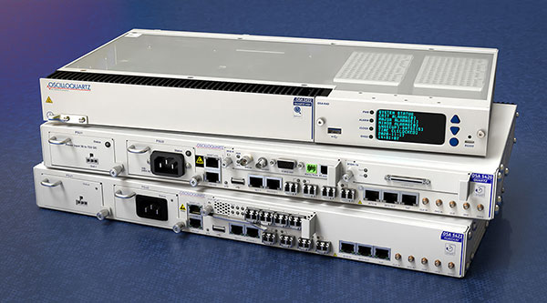
    UrsaNav’s latest trial used the OSA 5420 series grandmaster clock with built-in GNSS receiver. Timing stability from GPS was measured for several days. This was then replaced with eLoran for the same period with no loss of stability.

    The test was conducted indoors where GNSS signals are not usually available, potentially extending the availability of precise UTC timing to many more environments.

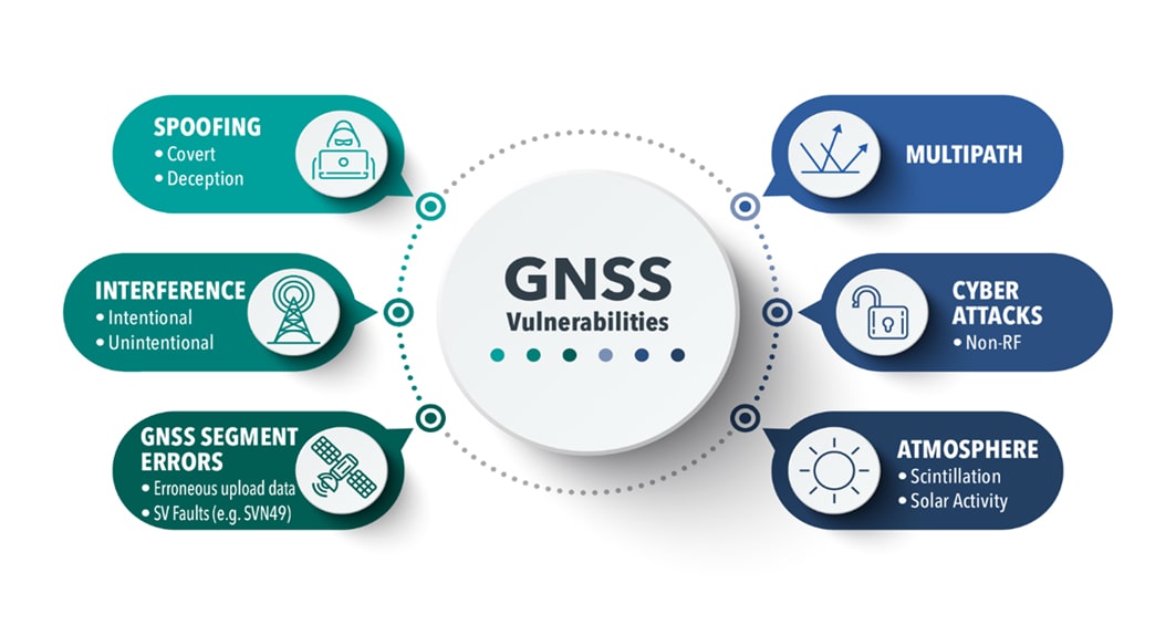
    “Commercially available GNSS jammers and spoofers are easy and cheap for attackers to acquire,” explained Nir Laufer, VP, product line management, Oscilloquartz, ADVA. “That’s part of the reason why we’re seeing a growing number of incidents across the world of blocked or misleading signals. If power utilities, enterprises, service providers and governments continue to rely on GNSS alone, it’s only a matter of time before the consequences become very serious. That’s why we’re committed to tackling GNSS vulnerabilities with advanced technologies like our ePRTC offering, cesium atomic clocks and our optical timing channel solution. Now that UrsaNav has demonstrated the power of our OSA 5420 series to utilize eLoran in the event of outages, we have another very important tool to ensure the quality and availability of time-sensitive services.”

    A demo showed how ADVA’s synchronization technology enables protection for critical infrastructure that needs ultra-reliable aPNT solutions. (Photo: Business Wire)
    The demo showed how ADVA’s synchronization technology enables protection for critical infrastructure that needs ultra-reliable aPNT solutions. (Photo: Business Wire)
  • BAE Systems chooses Spirent Federal CRPA test system

    BAE Systems chooses Spirent Federal CRPA test system

    For controlled reception pattern antenna (CRPA) testing and M-code testing for military GPS receivers

    Image: Spirent Federal
    Image: Spirent Federal

    BAE Systems has selected Spirent Federal Systems to provide a CRPA Test System to support M-code military GPS technology development.

    BAE Systems is developing an advanced military GPS receiver and improving the capabilities of size-constrained and power-constrained military GPS applications, including precision-guided munitions and handheld devices.

    Spirent Federal is qualified to provide essential test equipment and support in the pursuit of resilient, accurate PNT data in GPS-degraded Navigation Warfare (NAVWAR) situations, Spirent stated in a press release.

    The Spirent CRPA Test System is a development of its GSS9000 Series platform. It can test

    • controlled reception pattern antennas (CRPAs)
    • MNSA and AES M-code
    • jamming and spoofing threats and mitigation
    • ultra-high-dynamic vehicle applications
    • inertial navigation systems
    • additional encrypted military signals, Y-code and SAASM
    • and more

    CRPAs provide proven and effective protection against jamming in high-interference environments. The Spirent CRPA Test System can simulate 16+ individual elements with a separate RF output per antenna element.

    For the 16-element test system, concurrent simulation of GNSS signals, signals from spoofers and repeaters, and interference from multiple jammers — including Blue Force Electronic Attack (BFEA) jamming waveforms — results in more than 1,000 simultaneous independent channels and signals simulated across a phase-calibrated precise wavefront.

    “The CRPA Test System is the culmination of over 35 years of R&D and industry leadership and is perfectly positioned to help with next-generation MGUE modernization,” said Ellen Hall, president/CEO of Spirent Federal. “Our robust M-code test capabilities support BAE Systems’ advances in M-code technology.”

    Spirent can provide GNSS and interference signal simulation solutions for every stage in the CRPA design and verification process. To learn more, visit Spirent Federal’s CRPA Test System page.

  • Geospatial imagery shows activity at Iranian nuclear facility

    Geospatial imagery shows activity at Iranian nuclear facility

    A team with Stanford University’s Center for International Security and Cooperation (CISAC) used BlackSky’s geospatial imagery and burst collection technology to track and monitor activity at a secretive Iranian nuclear facility in a new intelligence study. The study tracks and monitors activity at the Natanz nuclear facility in Iran.

    Screenshot: Janes.com video/BlueSky
    Screenshot: Janes.com video/BlueSky

    “The BlackSky/CISAC research team demonstrated the power of combining rapid revisit satellite imagery, human domain expertise and AI/ML (artificial intelligence/machine learning) techniques to identify and understand activity at Natanz, which was previously unknown to much of the world,” said Patrick O’Neil, chief data scientist at BlackSky. “Observations that provide real-time, activities-based insights have the potential to change the world.”

    BlackSky’s high-revisit satellite imagery enabled researchers at Stanford University’s Center for International Security and Cooperation (CISAC) to monitor the pattern of life at the Natanz nuclear facility and gain a better understanding of activity and events at the site.

    BlackSky’s satellites provide high, intraday revisit capabilities, allowing CISAC’s research team to receive multiple images a day, throughout the day, rather than just one image collected at roughly the same time each day.

    BlackSky satellites are also capable of capturing a sequence of up to 20 images within a matter of minutes, known as a burst collection, and then splicing them together. Instead of a single picture, burst collections are geospatially normalized and joined together to generate a moving sequence of activity. With BlackSky’s assistance, the research team was able to witness trucks emerging from the facility’s underground tunnels.

    Allison Puccioni, a renowned imagery analyst and BlackSky consultant, assembled a research team at Stanford University, with help from Rose Gottemoeller, diplomat, former NATO deputy secretary, and visiting professor at Stanford. The pair enlisted two principal research assistants in geospatial science to develop a sophisticated situational-intelligence program to monitor the Natanz nuclear facility.

    Natanz is Iran’s primary facility for advanced uranium enrichment and is an active political and military location driven by concerns about the country’s nuclear operations.

  • Trio of HawkEye 360 formation-flying microsatellites launched for RF geolocation

    Trio of HawkEye 360 formation-flying microsatellites launched for RF geolocation

    The HawkEye 360 constellation detects and geolocates RF signals for maritime situational awareness, emergency response, national security and spectrum analysis applications.

    Cluster 3 satellites fly in formation, joining Clusters 1 and 2. (Artist's rendering: Hawkeye 360)
    Cluster 3 satellites fly in formation, joining Clusters 1 and 2. (Artist’s rendering: Hawkeye 360)

    HawkEye 360 Inc. announced the successful launch of its Cluster 3 radio frequency geolocation microsatellites built by Space Flight Laboratory (SFL). Carried aboard the June 30 SpaceX Transporter 2 mission, the Cluster 3 formation-flying microsatellites quickly established communication with the company’s satellite operations center.  They join in orbit the HawkEye 360 Cluster 2 and Cluster 1 Pathfinder satellites.

    The HawkEye 360 Constellation detects and geolocates RF signals for maritime situational awareness, emergency response, national security and spectrum analysis applications. Cluster 3 significantly expands HawkEye 360’s capacity, and is part of its second generation of advanced RF-sensing satellites.

    “With the addition of our second-gen satellites, we’ll offer more frequent, timely and actionable data and insights to our government, commercial and humanitarian partners,” said CEO John Serafini.

    “The increased revisit frequency and capacity Cluster 3 brings to our constellation are essential to detecting, characterizing, and understanding the continuously changing RF activity important to our clients,” said Alex Fox, Executive Vice President for Sales and Marketing.

    Seven more clusters are fully funded and scheduled for launch in 2021 and 2022 to achieve collection revisits as frequent as every 20 minutes, Fox said. “Each cluster will offer new innovations to address a rapidly growing set of requirements needed by our defense, security and commerce clients. We plan on expanding the constellation past the initial 10 clusters to achieve near-persistent monitoring of global RF activity, which will drive even more value and ensure our continued dominance in the industry.”

    HawkEye 360 delivers a layer of intelligence to help understand human activity on Earth. The constellation detects, characterizes and precisely geolocates these RF signals from a broad range of emitters, including VHF marine radios, UHF push-to-talk radios, maritime and land-based radar systems, L-band satellite devices and emergency beacons.

    By processing and analyzing these RF data, the company delivers actionable insights for national, tactical and homeland security operations, maritime domain awareness, environmental protection and new applications in the commercial sector, the company said.

    The HawkEye 360 launch brings to 20 the total number of SFL satellites placed into orbit in less than a year. The Cluster 3 satellites were built on SFL’s 30-kg Defiant microsatellite bus.

    HawkEye 360 selected SFL due to the importance of formation flying by multiple satellites for successful RF geolocation. SFL is the acknowledged leader in developing and implementing high-performance attitude control systems that make it possible for relatively low-cost nanosatellites and microsatellites to fly in stable formations while in orbit.

    The previous HawkEye 360 satellite clusters built by SFL were the Pathfinder launched in 2018 and Cluster 2 in January. Each Cluster is comprised of three satellites.

    Other launches of SFL-built satellites in the past year include missions developed for the Norwegian Space Agency (NOSA) in Norway, the Dubai-based Mohammed Bin Rashid Space Centre (MBRSC) in the United Arab Emirates, GHGSat Inc. of Canada, Space-SI of Slovenia, and a Canada-based telecommunications company.

  • GAO Report checks defense on PNT tech

    GAO Report checks defense on PNT tech

    Cover: USGAO Report
    Download the GAO Report.

    A May report by the Government Accountability Office (GAO) explores Department of Defense (DOD) strategy for positioning, navigation and timing (PNT) technology to complement GPS. The 51-page report takes a comprehensive view of alternative PNT policy and leadership across the department.

    While GPS will remain the core of DOD’s PNT solution, it will use other PNT technology to complement GPS or as an alternative for when GPS is degraded or unavailable. DOD is exploring both improved sensors to provide relative PNT information, and external sources to provide absolute positioning and navigation.

    DOD also is working to create common standards and interfaces to help integrate and field new PNT technologies faster and at lower cost. DOD also is developing its PNT modeling and simulation capabilities to evaluate the performance of new PNT technologies.

    Challenges for DOD

    Officials from across DOD and experts told GAO that alternative PNT solutions are not prioritized within DOD. For example, there is no central program office responsible for developing the variety of alternative PNT technologies across DOD.

    DOD’s continued reliance on GPS, despite known GPS vulnerabilities to disruption, presents a challenge for obtaining sufficient support to develop viable alternatives. Defense officials and experts also said challenges in establishing clear PNT performance requirements hinder technology development.

    In response, GAO developed six policy options that may help address challenges with developing and integrating alternative PNT technologies. The policy options identify possible actions by policymakers, who may include Congress, federal agencies and industry groups.

    1. Increase collaboration. Consider mechanisms to coordinate across DOD to clarify responsibilities and authorities in prioritizing the need for alternative PNT technologies.
    2. Focus on resiliency. Consider selecting the most resilient technologies as the cornerstone of the PNT suite for military missions, rather than defaulting to GPS.
    3. Clarify requirements. Consider opportunities to clarify what level of PNT performance actually is needed for missions, rather than defaulting to requirements that match GPS performance.
    4. Coordinate with industry. Consider ensuring DOD and industry coordinate so that industry is prepared to meet DOD’s needs, and DOD can leverage industry advances.
    5. Institutionalize open architecture. Consider making the open architecture initiative more permanent, including providing funding.
    6. Analyze vulnerabilities. Consider having DOD conduct ongoing analysis of vulnerabilities of different PNT systems.

    The GAO reviewed technical studies, agency documents, and other key reports; interviewed government officials and researchers about alternative PNT technologies; and convened a three-day meeting of experts from government, non-governmental organizations, academia and industry.

  • GPS III SV-05 encapsulated ahead of June 17 launch

    GPS III SV-05 encapsulated ahead of June 17 launch

    The fifth GPS III satellite was encapsulated within a SpaceX payload fairing on June 9 in preparation for its June 17 launch.

    The U.S. Space Force’s Space and Missile Systems Center’s Lockheed Martin-built GPS III Space Vehicle 05 satellite was encapsulated within a SpaceX payload fairing at Astrotech Space Operations Florida facility on June 9 in preparation for launch, scheduled for June 17 from Cape Canaveral Space Force Station.

    The 15-minute launch window opens 12:09 p.m. EDT. If SpaceX provides a live feed to view the launch, it will be available here.

    Encapsulation of the satellite within the payload fairing protects the satellite from the impact of dynamic pressure and aerodynamic heating during its harrowing journey through the earth’s atmosphere, and supports the ability to communicate with the satellite until separation from the launch vehicle on orbit.

    “The GPS III program continues to make strides in modernizing the GPS constellation for the United States Space Force, maintaining the ‘gold standard’ for position, navigation and timing,” said Col. Edward Byrne, Medium Earth Orbit Space Systems division chief, “SV05 is not only the first-ever USSF satellite launched on a previously flown booster, but also is the 24th military-code (M-xode) satellite introduced to our constellation, the last needed to bring M-code to full operational capability.”

    GPS III SV05 will join the current 31-satellite operational constellation to continue to provide the gold standard in positioning, navigation and timing services for more than four billion users worldwide.

    The Space and Missile Systems Center, located at Los Angeles Air Force Base in El Segundo, California, is the U.S. Space Force’s center of acquisition excellence for acquiring and developing military space systems. Its portfolio includes the development of advanced space and launch capability and systems, global navigation satellite systems, military satellite communications, defense meteorological satellites, space launch and range systems, satellite control networks, space-based infrared systems, and space situational awareness capabilities.

    GPS III SV05 is encapsulated within a SpaceX payload fairing at Astrotech Space Operations Florida in preparation for its June 17 launch. (Photo: Lockheed Martin)
    GPS III SV05 is encapsulated within a SpaceX payload fairing at Astrotech Space Operations Florida in preparation for its June 17 launch. (Photo: Lockheed Martin)


  • Controversial GAO report on DOD nav webinar June 15

    Controversial GAO report on DOD nav webinar June 15

    webinar ad

    On May 10, the Government Accountability Office (GAO) released a report on navigation efforts n the Department of Defense (DOD). Among its findings were that the department regularly fails to establish validated navigation and timing requirements for systems and instead defaults to the capabilities of GPS. Also, that alternate positioning, navigation and timing (PNT) efforts are not prioritized, and sometimes actively opposed, by forces within DOD.

    One of the report’s more startling recommendations is that the department change its focus from GPS as the central pillar of its PNT strategy going forward in favor of resilient technologies.

    The Institute of Navigation (ION) and Resilient Navigation and Timing Foundation (RNTF) are hosting a webinar to discuss the report with two of its authors on June 15 at 11 a.m. ET. Two members of the Senate Armed Services Committee staff have also been invited as panelists.

    After a panel discussion moderated by Dana A. Goward, president of the RNT Foundation, attendees will have the opportunity to ask questions of the panelists.

    The event is open to the public, but attendees must register in advance.

  • US Congress may move against Chinese-made drones

    US Congress may move against Chinese-made drones

    The FLIR M440 UAV. (Photo: Teledyne FLIR)
    The FLIR M440 UAV. (Photo: Teledyne FLIR)

    A bill moving through the U.S. Congress would impose a five-year ban on United States government purchases of drones manufactured or assembled in China, reports The Associated Press. The measure reflects bipartisan concerns that the unmanned aerial vehicles (UAVs) made in China could facilitate Chinese spying on critical infrastructure.

    Major commercial and consumer UAV-maker company DJI is based in Shenzhen, China. Many of its small, low-altitude drones are employed by local and regional government users in law enforcement, emergency response and surveying. The ban could affect police departments that rely on federal funds for equipment. In 2020, the Department of Homeland Security halted such grants for Chinese-made drones.

    Chinese-made components, including GNSS receivers and inertial sensors, are not addressed in the bill, and the Pentagon has acknowledged that many components for non-Chinese-company drones are made in China.

    While the ban wouldn’t go into effect until 2023, many federal agencies have already imposed temporary restrictions on the use of Chinese drones. The Interior Department had flown more than 11,000 drone missions before January, when the agency temporarily grounded its fleet of more than 500 DJI drones over cybersecurity concerns, according to The Hill. The Hill cites a May 6 Pentagon report. The report found no malicious code in the software for DJI’s Government Edition drones.

    An analysis by Booz Allen Hamilton released in June 2020 found no evidence that DJI drones have shared sensitive information with the company or the Chinese Communist Party.

    In August 2020, the Defense Department issued approval to drones from five companies:

    • Skydio’s X2-D. Skydio is based in Redwood City, California.
    • Parrot’s Anafi USA. While Parrot is based in Paris, France, the ANAFI USA drone is manufactured in the United States for U.S. customers.
    • Teledyne FLIR’s Flir M440 Ion. The drone was originally made by Altavian in Florida, which was acquired by FLIR in December 2020, which was subsequently acquired by Teledyne Technologies in January. Teledyne FLIR is headquartered in Wilsonville, Oregon.
    • Teal Drones’ Golden Eagle. Teal Drones is based in Salt Lake City, Utah.
    • Vantage Robotics’ Vesper. Vantage is based in San Leandro, California.

  • TRX Systems delivers NAVWAR threat mapping for foot soldiers

    TRX Systems delivers NAVWAR threat mapping for foot soldiers

    Image: TDK/U.S. Army
    Image: TDK/U.S. Army

    Electronic Warfare Kit enables dismounted soldiers to detect, map and mitigate the impact of navigational warfare (NAVWAR) attacks

    TRX Systems, developer of NEON GPS-denied location solutions, has delivered the TRX Systems Dismount Electronic Warfare (EW) Kit prototype to the U.S. Army.

    Developed for U.S. Army Rapid Capabilities and Critical Technologies Office (RCCTO), the TRX EW Kit is designed to extend EW and signal intelligence for the dismounted warfighter.

    The kit adds powerful new capabilities to the company’s NEON Personnel Tracker-MIL solution, expanding the integration between its NEON Location Service and ATAK application to better equip dismounted personnel for detection and mapping of jamming and spoofing attacks.

    New NEON functionality includes:

    • Robust Interference Detection. Rapidly detects and geo-references NAVWAR threats including GPS jamming, repeating and spoofing.
    • NAVWAR Threat Mapping. Increases situational awareness by geo-referencing and mapping detected threats through integration with ATAK and EW platforms.
    • Reliable Dismount Location Data. Mitigates the impact of NAVWAR attacks by eliminating erroneous GPS inputs while continuing to deliver reliable location data to dismounted users.
    • Integration with NAVWAR Devices. Integrates threat data from Orolia Defense & Security BroadSense Nano and other devices already carried by warfighters to provide a fused NAVWAR threat indication.

    The NEON Personnel Tracker Military (PT-MIL) uses a suite of patented algorithms that fuse GNSS, an inertial sensor, ultra-wideband (UWB) and other inputs to deliver reliable position data to dismounted personnel operating in the presence of compromised or intentionally denied GNSS signals.

    With the new EW Kit functionality, warfighters will receive real-time situational awareness into jamming or spoofing threats at their immediate location and from other dismount personnel sharing data over the TAK network.

    The EW Kit is integrated via soldier plug-ins, enabling threats discovered and mapped by dismounts to be fused into the overall NAVWAR threat picture.

    “In today’s conflict zones, it’s becoming increasingly easy for adversaries to launch electronic attacks against GNSS systems using low-cost jammers built with readily available commercial technology,” said Carol Politi, president and CEO of TRX Systems. “The EW Kit developed in the RCCTO program provides dismount soldiers with clear insight into their NAVWAR environment by rapidly detecting and characterizing these NAVWAR attacks, and it mitigates the impact by eliminating compromised data from their position solution.”

  • BAE Systems receives $325M for M-code GPS modules

    BAE Systems receives $325M for M-code GPS modules

    BAE Systems Inc. has received a $325.5 million contract from the Defense Logistics Agency for advanced military code (M-code) GPS modules that will provide reliable and secure positioning, navigation and timing data with anti-jamming and anti-spoofing capabilities.

    The modules will help warfighters conduct operations in contested electronic warfare environments.

    “Our state-of-the-art GPS technology works with the advanced military M-code signal to provide reliable information to the warfighters who depend on it,” said Greg Wild, director of Navigation and Sensor Systems at BAE Systems. “This contract will ensure the availability of M-code module inventory to build advanced, next-generation GPS receivers.”

    Under the multi-year contract, BAE Systems will deliver Modernized GPS User Equipment (MGUE) Increment 1 Common GPS Modules (CGMs) compatible with the advanced M-code signal to support the U.S. Department of Defense and international allies through 2030.

    BAE Systems will manufacture the modules, manage their inventory on behalf of the Defense Logistics Agency, and use them to build military-grade GPS receivers for ground and precision-guided munitions.

    BAE Systems’ portfolio of M-code GPS receivers provides flexible, efficient, and reliable navigation and guidance solutions for airborne systems, precision munitions, handheld receivers, and embedded applications.

    The company’s Miniature Precision Lightweight GPS Receiver Engine – M-Code (MPE-M) — the smallest M-code solution on the market — and the NavStrike-M GPS receiver for precision-guided munitions are both available today. Additional receivers from the company’s military GPS family are in development for transition to M-code.

    Photo: BAE Systems
    Photo: BAE Systems
  • New GAJT-410MS provides anti-jamming in marine environments

    New GAJT-410MS provides anti-jamming in marine environments

    The GAJT-410MS provides anti-jamming to marine vessels. (Image: NovAtel)
    The GAJT-410MS provides anti-jamming to marine vessels. (Image: NovAtel)

    Hexagon | NovAtel has released the GAJT-410MS in response to the increase of interference and jamming in marine environments worldwide. The GAJT-410MS is the company’s latest addition to its proven GPS Anti-Jam Technology (GAJT) for the commercial and defense marine markets.

    The low size, weight and power (SWaP) variant protects civil and military operations from interference and jamming, with jammer direction-finding capabilities for enhanced situational awareness in the marine environment.

    The GAJT-410MS provides dynamic protection on both GPS L1 and L2 bands, as well as Galileo E1, QZSS L1 and L2 and SBAS L1 to combat intentional and unintentional interference. If a vessel experiences jamming, the device’s direction-finding capabilities provide improved situation awareness of their RF environment to identify and locate the source of the jamming signals.

    The commercial off-the-shelf, non-ITAR solution is easy to install or retrofit onto existing fleets, enabling assured PNT for continuous operations, cybersecurity and safe navigation at sea, NovAtel said.

    Interference, both benign and malicious, is a challenge facing civilian and military operations. Commercial marine applications like shipping, tankers and bulk carriers are under threat from interference targeting their navigation and cybersecurity. Without assured positioning, these vessels can drift off-course and place the vessel, crew and cargo at risk.

    Nearshore marine applications like survey, construction and piloting also require reliable positioning for uninterrupted operations in crowded waterways and RF environments. Interference mitigation and jammer direction-finding for advanced situation awareness ensure users acquire assured positioning, navigating and timing (PNT) while identifying and limiting risk from interference sources.

    “Assured navigation and cybersecurity defenses are growing priorities for marine users as global threats from interference and jamming increase,” said David Russell, marine segment portfolio manager for Hexagon’s Autonomy & Positioning division. “The GAJT-410MS is an anti-jam solution protecting vessels from interference and jamming disruptions to ensure continuous operations wherever your application takes you. With GAJT, your position, navigation and timing are protected and assured.”

    The GAJT-410MS is the latest iteration of proven, high-performance anti-jam products from NovAtel. It includes flexible mounting options, jammer presence and direction-finding capabilities for advanced situation awareness.

  • GAO Report: ‘Use resilient tech vs. GPS as DOD primary PNT’

    GAO Report: ‘Use resilient tech vs. GPS as DOD primary PNT’

    Cover: USGAO Report
    Click to open the GAO Report.

    A new report by the Government Accountability Office (GAO) questioned the Department of Defense (DOD) strategy of keeping GPS as the central pillar of its positioning, navigation and timing (PNT) capabilities.

    It said policymakers “could consider selecting the most resilient technologies as the cornerstone of the PNT suite for military missions, rather than defaulting to GPS.”

    The 51-page report takes a comprehensive view of alternative PNT policy and leadership across the department. Its findings are an interesting and informative look at issues and efforts.

    Increasing demands

    The report comes at a time when U.S. forces have been seeing increasing interference with their own and allied GPS-enabled systems. The Organization for Security and Cooperation in Europe has regularly reported that its surveillance drones in the Ukraine have been jammed. Chinese press recently bragged that jamming caused U.S. Navy ships in the South China Sea to switch from using GPS to the Chinese BeiDou system. Additionally, U.S. military commanders have regularly described the Middle East as the most contested electronic warfare area on the planet, in large part because of regular interference with GPS signals.

    The GAO study also comes on the heels of a provision in the National Defense Authorization Act (NDAA) for this year which directs DOD to provide non-GPS PNT to combatant commanders by 2023. The act says this timeline is consistent with responding to Joint Urgent Operational Needs, a formal method for commanders to communicate with department leadership. According to some sources, this suggests that the Pentagon has been receiving such requirements from field commanders, but has not responded to them in what Congress considers a timely manner.

    Alternative PNT “not a priority,” resisted

    Despite chronic GPS signal interference across the globe, outside experts and officials across the DOD told the GAO study team that developing alternative sources of PNT was not a priority for DOD. One example cited was the lack of a central program office.

    One expert said, “PNT — It’s everyone’s need, but nobody’s business.” Another expert said, “Everyone wants to use [PNT], no one wants to pay or care for [PNT].” One DOD official characterized alternative PNT as an afterthought. DOD’s PNT Roadmap states that PNT capabilities, despite being mission critical, are not normally considered a key requirement, but rather may be treated as “a second-tier requirement.”

    Worse, the report indicated that some forces within the department resist alternative PNT efforts.
    According to one DOD official cited anonymously in the report “bureaucratic and political obstacles [represent] the biggest challenges for alternative PNT” and “anything that threatens GPS, such as alternative PNT technologies, faces pushback.”

    The report cited another DOD official as agreeing that “there is an impression that the GPS program has a lot of political clout within DOD, and that those trying to develop alternative PNT technologies may face political challenges.”

    Realistic requirements

    Many missions do not need the accuracy provided by GPS, according to the report. Nevertheless. DOD programs often default to GPS performance standards when developing requirements. Many alternative technologies, while more resilient, are unable to achieve the same accuracy as GPS and therefore fail to meet the over-stated requirements.

    Open architecture

    Both DOD and GAO see development of modular open system architecture (MOSA) as key to PNT success in the future. This will allow addition of new PNT sources to a platform without the need for a major retrofit. With MOSA, all that would be needed is a new sensor module for the desired PNT source.

    The GAO report endorsed this approach and encouraged DOD to institutionalize it with dedicated funding.

    Working with industry

    Decades of civil GPS use have benefited DOD in many ways. Broad academic and commercial research has resulted in a host of applications and improvements in the size, weight, and power requirements of equipment, as well as lowered costs. These benefits would almost certainly not have been realized at the current scale if the market for GPS equipment and apps had been restricted to military users.

    The 2021 NDAA directs the department to “…enable civilian and commercial adoption…” of the GPS alternative technologies it develops for field commanders. The GAO report suggests DOD also work to leverage industry advances in technologies.

    Scope and recommendations

    GAO’s tasking for this effort did not include examining efforts to make GPS signals and equipment more resilient to disruption, nor use of non-U.S. satellite navigation systems. Neither were non-defense uses of PNT, nor improvements in such things as tactics, techniques, and procedures considered.

    The study focused solely on department efforts to complement GPS services.

    Six recommendations for policymakers are included in the report:

    1. Increase Collaboration — Consider mechanisms to coordinate across DOD to clarify responsibilities and authorities in prioritizing the need for alternative PNT technologies.
    2. Focus on Resiliency — Consider selecting the most resilient technologies as the cornerstone of the PNT suite for military missions, rather than defaulting to GPS.
    3. Clarify Requirements — Consider opportunities to clarify what level of PNT performance is actually needed for missions, rather than defaulting to requirements that match GPS performance.
    4. Coordinate with Industry — Consider ensuring that DOD and commercial industry coordinate so that industry is prepared to meet DOD’s needs, and DOD can leverage industry advances.
    5. Institutionalize Open Architecture — Consider making the open architecture initiative more permanent, including providing funding.
    6. Analyze Vulnerabilities — Consider having DOD conduct ongoing analysis of vulnerabilities of different PNT systems.

    The May 2021 GAO report “Defense Navigation Capabilities: DOD is Developing Positioning, Navigation, and Timing Technologies to Complement GPS” is available here.


    Dana Goward is president of the Resilient Navigation and Timing Foundation.


    Feature image: gorodenkoff/iStock/Getty Images Plus/Getty Images