There’s strength in numbers. That’s why antenna systems are increasingly upgrading from single-input/single-output (SISO) architectures to multiple-input/multiple-output (MIMO).
Whether it’s military communications, public safety, smart meters or smartphones, more antenna elements increase channel capacity, reduce transmitting power and increase resistance to multipath fading.
But the smaller the device, the more challenging MIMO becomes from a design perspective, such as providing ample isolation between each antenna element.
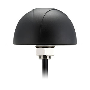
The Pantheon MA750 antenna. (Photo: Taoglas)
That’s key for ensuring that they don’t interfere with one another, which would reduce channel capacity and system performance. For example, the Taoglas Pantheon MA750 is just 85.7 mm tall, with a 145.6 mm diameter, yet its five antennas have 20 dB+ of isolation.
Three additional key features to look for are high radiation efficiency, low envelope correlation and a built-in ground plane, which provides the flexibility to mount the antenna on metal or plastic without affecting performance.
For applications with long cable runs, such as 10 m, low-loss cables are critical for ensuring that a MIMO antenna can establish and maintain a reliable connection. If the antenna is likely to get wet or struck, it is best to use models with IP67 housings made with ultra-durable materials, such as Wonderloy PC-540 PC/ABS alloy.
Enova Robotics makes security robots. “At Enova Robotics, we know reliability is imperative when you are in the business of security and surveillance. That’s why we chose to work with Taoglas and chose their Pantheon MA750 for our PGuard Robot,” said Ahmed Dimassi, production and supply manager, Enova. “This unique antenna delivers powerful MIMO antenna technology, and we knew we could rely on their team to reduce the risks and time associated with integrating it into our technology.”
BAE Systems is investing more than $100 million to build a state-of-the-art facility in Cedar Rapids, Iowa, expected to be completed in 2022. The facility will support the company’s newly acquired Navigation & Sensor Systems business, which makes mission-critical military GPS products.
The new building will bring the company’s local design and production employees from multiple locations into a single center of excellence with modern manufacturing, engineering and office space.
“Our world-class military GPS business is built on the rich talent pool in Greater Cedar Rapids,” said John Watkins, vice president and general manager of Precision Strike & Sensing Solutions at BAE Systems. “This investment will provide our high-tech engineering and manufacturing experts with a world-class workspace and the tools to enhance operational excellence.”
The facility will improve operational efficiency, optimize production, and enhance the company’s ability to deliver high-quality military GPS products to the warfighter.
The 278,000-square-foot research and development center will be located on a 32-acre site. The building will include a large factory; several hundred offices, workstations, and flexible work spaces; and classified and unclassified labs. The building was designed for growth, with the ability to add 50,000 square feet of additional space.
NATO forces are deployed in some of the world’s most aggressive electronic-warfare (EW) environments. Intentional interference comes both from “personal protection” devices and large, high-powered EW assets.
To navigate despite EW, armed forces need reliable and resilient GNSS/GPS positioning with anti-jam technology. The Light Dragoons — a light cavalry regiment of the British Army — are in a perfect position to test anti-jam technology for assured positioning, navigation and timing (A-PNT).
The Light Dragoons were deployed as the United Kingdom’s Light Cavalry contribution to “Battlegroup Poland,” part of NATO’s enhanced Forward Presence. On the front line, the Light Cavalry engage in reconnaissance, mark targets for indirect fires, and prepare routes for the rest of the force. In this role, being prepared for EW is essential.
To test A-PNT technologies, the Light Cavalry took part in Project Thundercat, a light cavalry capability investigation run by the Armoured Trials and Development Unit (ATDU). A Hexagon | NovAtel GPS anti-jam technology (GAJT) antenna, the GAJT-410ML, was fitted to a Jackal high-mobility transporter and integrated with its onboard positioning system.
GAJT successfully defeats jamming on GPS L1 and L2 and Galileo E1 frequencies. When interference is detected, GAJT recognizes the unwanted interference and reduces reception in that direction. The result is a more resilient GNSS solution, protected measurements and A-PNT.
The Light Dragoons found that GAJT successfully protected their positioning system despite experiencing interference. The GAJT-410ML antenna was easy to install in a simple plug-in-and-go process.
In upcoming experiments, the British Army will use NovAtel technology to gain electronic situational-awareness data to characterize the radio frequency environment.
GAJT systems are offered by NovAtel with customized offerings for land, marine and air applications.
The Light Dragoons test NovAtel GAJT anti-jamming antennas in Project Thundercat. (Photo: Photo: British Army)
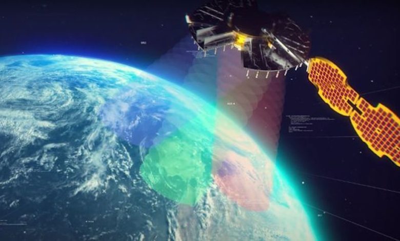
The NTS-3 experimental satellite will be launched in 2023, according to reports from C4ISRNET and Space News. The United States military will use the satellite for positioning, navigation and timing (PNT) as a supplement to GPS.
The satellite was originally set to launch in 2022.
The Air Force Research Laboratory (AFRL) plans to use the additional time to reduce risks and conduct more ground testing.
Navigation Technology Satellite 3 will help guide future GPS satellites, a priority area for the military as the technology has become easier to spoof and jam. Among other features, NTS-3 will have steerable beams for regional coverage and a software-defined payload that can be reprogrammed on orbit.
AFRL discussed the delay in a media roundtable held Wednesday, reports C4ISRNET. AFRL Commander Brig. Gen. Heather Pringle said that shift was out of the lab’s control since the satellite will launch as a rideshare with a U.S. Space Force payload, and that launch had been pushed back.
AFRL plans to experiment with the satellite in geosynchronous orbit for one year, testing PNT signals and architectures as well as ground-based command and control systems and software-defined radios. Following testing, NTS-3 will transition to the U.S. Space Force and integrate into the service’s other PNT capabilities.
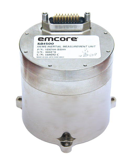
The non-ITAR status greatly increases the marketability of the SDI500/SDI505 IMUs to international customers. Plus, Emcore releases new SDI170 IMU and is awarded defense contract.
Emcore’s dual-use SDI500/SDI505 Revision F inertial measurement units (IMUs) have received a determination that they are not subject to the International Traffic in Arms Regulations (ITAR) administered by the U.S. Department of State. Emcore has likewise determined that its SDN500 inertial navigation system (INS) is not subject to ITAR.
The determination of non-ITAR status is expected to dramatically increase the size of the market that Emcore can address with its quartz micro-electro-mechanical systems (QMEMs) IMU and INS devices.
Photo: Emcore
Ranked Top in Trade Study. The SDI500/505 IMU was ranked first in overall accuracy, reported Emcore, in a U.S. military-commissioned trade study of 19 IMUs being evaluated as an alternative to the Honeywell HG1700 for various weapons systems.
The objective of the third-party independent study was to deliver a comprehensive report to the government and make a recommendation supported by clear and compelling technical, financial, and other relevant data collected regarding the most advantageous IMU products and services available in the market today. 19 IMUs of various technologies, complexity, cost, and developmental status, from leading manufacturers, were evaluated in short and long flyout simulations against the HG1700.
The dual-use non-ITAR SDI500/505 IMUs are designed to achieve the demanding performance levels required in sophisticated systems, including weapons guidance and targeting, commercial and defense fixed-wing aircraft and helicopters, unmanned autonomous vehicles (UAVs), and a wide variety of other high-precision commercial, industrial, marine, defense and space applications. They leverage quartz MEMS technology to deliver angle random walk (ARW) values of 0.02°/√hr with 1°/hr bias stability.
Defense Contract Award. In March, Emcore was awarded a development contract valued at $1.1 million by a major U.S. prime contractor to design and manufacture a high-end IMU for tactical intelligence and reconnaissance systems. The prototype phase has been successfully completed and as part of the contract in this follow-on phase, Emcore will deliver initial production units that will be used for proof of manufacturing and system level qualification.
The custom IMU will be based on Emcore’s proprietary closed-loop fiber-optic gyro (FOG) technology that delivers proven CSWaP (cost, size, weight and power) and performance advantages over other FOGs and competing technologies. It is designed to deliver the highest level of performance in Emcore’s tactical IMU product line, exceeding Emcore’s EN-300. Emcore’s FOG IMU technology delivers ten times the bias performance of legacy systems in compact form-, fit- and function-compatible packages.
New SDI170 IMU. Emcore also launched a replacement IMU. The new SDI170 quartz MEMS tactical-grade IMU is designed as a form-, fit- and function-compatible replacement for the HG1700-AG58 ring-laser gyroscope (RLG) IMU, but with superior overall performance, versatility and a significantly higher mean time between failures (MTBF) rating over ruggedized environments.
The SDI170 IMU is suitable for continuous-use applications with no wear-out components and delivers highly linear accelerometer performance and longer life compared to the HG1700 IMU. It is not ITAR controlled and has completed extensive internal and external customer testing to confirm compatibility to replace legacy products.
The unit is designed for a wide range of high-precision, integrated commercial and defense applications including aircraft Attitude Heading Reference Systems (AHRS), GPS-aided navigation, ground surveying, mobile mapping, ROVs, autonomous vehicles, tactical weapons, and stabilization platforms.
Non-ITAR Determination. As a result of this Commodity Jurisdiction (CJ) determination concluded by the U.S. Department of State, EMCORE’s SDI500/SDI505 Revision F commercial off-the-shelf (COTS) offerings were confirmed to be subject to the Export Administration Regulations (EAR) administered by the Department of Commerce (DOC). EAR classification typically results in fewer export-related restrictions and requirements. For this reason, this CJ determination for the SDI500/SDI505 will greatly increase the marketability of these IMUs to international customers.
The SDN500 is Emcore’s most advanced QMEMS INS/GPS tactical-grade system, combining the latest generation quartz gyros and accelerometers from the SDI500/SDI505, with high-speed signal processing and a 48-channel coarse/acquisition code GPS receiver into a powerful, tightly coupled guidance and navigation system.
“We would like to thank the U.S. Department of State for its evaluation of our commodity jurisdiction request and conclusion that our dual-use SDI500/SDI505 IMUs are not subject to ITAR,” said David Hoyh, Emcore’s director of sales and marketing for navigation products. “The determination of EAR status under the DOC enables more customers worldwide to benefit from these important, high-precision Emcore products.”
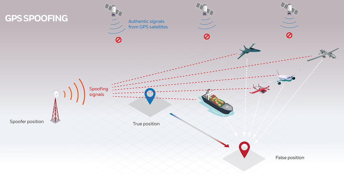
Are military tests that jam and spoof GPS signals a threat to the safety of civil aviation? If not, why? If so, who should do what about it?
Bernard Gruber
“I would offer that military tests that jam and spoof signals are a risk. The U.S. military takes great care to control tests of this nature in an informed and careful way in order not to affect civil aviation. I cannot speak for military tests that are conducted by other countries. We all recognize the worldwide proliferation of small and large jammers that can negatively affect GPS performance and satellite-born transmissions. Accordingly, GPS users should remain vigilant to these potential hazards, including spoofing, and consider alternative navigation means where risks dictate.” — Bernard Gruber
What are the remaining obstacles to creating a seamless indoor/outdoor positioning and navigation system that integrates data from GNSS, inertial guidance, indoor positioning systems, and signals of opportunity?
John Fischer
“The primary use case for indoor navigation is the smartphone. We can create multi-sensor navigation systems today that operate indoors, but not at the very small size, weight, power, and cost targets needed for the personal phone market. IMUs and processors continue to improve over time, so there may be a breakthrough there, but signals of opportunity (SoOP) navigation is promising and offers resiliency through diversity. The most ubiquitous SoOP is cellular and with ultra-reliable low latency (URLL) features coming on-line for 5G in the next few releases, we may see reliable positioning from 5G in indoor environments very soon.” — John Fischer
Two recent reports from the Organization for Security and Co-operation in Europe (OSCE) have described a recent increase in GPS jamming, presumably by Russian or pro-Russian forces in Ukraine. This comes as Russia has increased its troop numbers and activity along its border with Ukraine.
OSCE is charged with a Special Monitoring Mission (SMM) in Ukraine which observes and reports on how well both sides are adhering to the Minsk Protocol agreement. The agreement was signed in September 2014 by participants in the conflict in an effort to end open hostilities.
One of the ways the OSCE mission monitors activity and compliance in the region is with long range UAVs. As early as November 2014, the organization reported UAV operations being thwarted by interference with GPS signals.
Two recent OSCE spot reports have highlighted a resurgence in jamming.
An April 7 report described interference that prevented a UAV takeoff the previous day. While the organization’s UAVs had been experiencing increased interference since March, this was the first time since October 2014 that it had thwarted a mission before takeoff.
The report also documented an increasing level of jamming activity.
“Over the last two months, 62.5 percent of SMM long-range UAV flights encountered GPS signal interference and on 75 percent of the affected flights it occurred more than once.”
A second report on April 9 outlined continuing problems that caused missions to be aborted. It emphasized that this was a violation of the agreement signed by all parties and greatly hampered OSCE’s mission.
“Any GPS signal interference hinders the Mission’s ability to conduct effective monitoring and reporting of the security situation in line with its mandate. Long-range UAVs are an essential part of SMM operations, especially at night and in areas where the Mission’s monitoring and freedom of movement are restricted.”
GPS jamming and spoofing are important parts of Russia’s arsenal to counter any technological advantage the west may have over their forces. A 2015 Sputnik article bragged their electronic warfare kept U.S. cruise missiles from hitting their targets at the start of the 2003 invasion of Iraq. Also, that this advanced capability “renders aircraft carriers useless.”
Interference with GPS signals is a regular feature of Russian military and internal security operations.
The United States has formally expressed concerns about the recent increase in the number of Russian troops and their activity at the Ukrainian border. It has been reported that two U.S. Navy ships are on their way to the Black Sea to help monitor the situation.
Dana A. Goward is president of the Resilient Navigation and Timing Foundation.
New technologies use a variety of inputs to help ensure seamless navigation, even when GPS reception fails because of interference or jamming.
Honeywell has successfully demonstrated multiple alternate navigation technologies for military aircraft. These new products are intended to help ensure seamless navigation — even when GPS signals are blocked, interrupted or unavailable.
For military operations, GPS-jamming — intentional or not — can block vital signals from conveying critical information regarding positioning, navigation and timing (PNT). In these instances, it’s important for military vehicles and aircraft to be equipped with alternative navigation technologies, like celestial or vision navigation, to maintain operational readiness.
“For military operations, not having access to critical positioning and timing information can make or break a mission,” said Matt Picchetti, vice president and general manager, Navigation & Sensors, Honeywell Aerospace. “We’re very excited to roll out this robust lineup of alternate navigation solutions, which are specifically designed to address the needs of our military customers and give them the added layers of redundancy needed to successfully carry out their operations, even if they lose access to GPS signals.”
Illustration: Honeywell
Alternate navigation technologies provide a different means of measuring position, velocity and heading when GPS is disrupted. These technologies include:
Vision-aided navigation. This technology uses a live optical or infrared camera feed and compares it with maps to provide a passive, not jammable, highly accurate alternative PNT solution that provides GPS-like accuracy in GPS-denied or jammed conditions.
Celestial-aided navigation. Honeywell’s celestial-aided navigation technology observes stars and “reference objects” orbiting the earth such as satellites, which have known positions and velocities. This technology compares those reference objects to stars and can determine position and velocity, the same way a GPS receiver can.
Magnetic anomaly-aided navigation. This navigation technology measures magnetic strength using sensors and compares this data with known geographical magnetic maps to accurately identify the position of the aircraft relative to the Earth.
Prototypes of these alternate navigation systems will be available in 2022, with initial deliveries expected to start in 2023.
Honeywell navigation systems are used by nearly every aircraft flying to guide millions of passengers to their destinations. Since 1914 when the first autopilot used Honeywell gyroscopes to hold the plane stable during flight, Honeywell has delivered more than 500,000 high-performance inertial sensors across several platforms on land, in the air and at sea.
The inauguration of the Navigation Technologies Center took place in March. (Photo: IAI)
The new center will focus on developing and producing navigation systems for the battlefield, and plans to implement a co-developed, non-GPS accurate navigation technology
A Navigation Technology Center dedicated to developing and producing non-GPS navigation systems has been launched by Israel’s Ministry of Defense (IMOD) and Israel Aerospace Industries (IAI).
In the new center, IAI will develop and manufacture highly accurate inertial sensors for production of next-generation navigation systems, and will significantly increase their performance and capabilities. The sensors will be implemented in operational systems within Israel’s defense systems, enabling Israel to continue to address challenges of the modern battlefield.
The technology to be developed at the center is based on years of research and collaboration between the Directorate of Defense Research & Development (DDR&D) and IAI.
The center was established at the Tamam Division of IAI’s Systems Missiles and Space Group, which specializes in electro-optics and navigation. IAI has served as the inertial navigation system (INS) house of the State of Israel since 1964. Tamman is based in Yahud, a suburb of Tel Aviv.
“In launching the new compound, DDR&D demonstrates our position at the forefront of technology and its contribution to Israel’s technological independence,” said Brig. Gen. Yaniv Rotem, chief of research and development at DDR&D. “The extensive know-how and experience accumulated at DDR&D and Tamam, our partners, allowed us to challenge ourselves with this new endeavor and accomplish something impressive. The follow-up program is just as challenging, and we plan to work diligently until we prove the new capability in the various applications and in collaboration with IDF units.”
“Our partnership with IMOD DDR&D dates back many years,” said Avi Elisha, Tamam general manager. “We work together to achieve the ongoing enhancement of the innovative navigation systems for Israel. The new center we launched will allow highly accurate navigation capabilities with IAI’s unique technologies. Only a handful of countries have this technology, which is a game-changer in the field of inertial navigation.”
The United States Space Force’s Space and Missile Systems Center (SMC) has established a three-year multinational Project Arrangement that authorizes the loan of military code (M-code) capable GPS precise positioning service receiver cards to partnering nations for laboratory and field testing.
The arrangement — established in close coordination with the Department of Defense, Chief Information Officer and the Deputy Under Secretary of the Air Force for International Affairs — took effect in December 2020 when Canada became the first co-signer of the document.
The first receiver cards were delivered in February. France, Germany, the Republic of Korea and the United Kingdom also are projected to receive Military GPS User Equipment (MGUE) Increment 1 technology.
All partnering nations will conduct laboratory and field tests to evaluate the performance and compatibility of MGUE Increment 1 products with their respective platforms and share their findings and lessons learned. Australia, Italy, the Netherlands and Sweden have expressed interest and intent to join the agreement later this year.
M-code is an upgrade to the currently available GPS signals that provides more resilient positioning, navigation and timing solutions with enhanced security, anti-jam and anti-spoof capabilities.
The SMC, located at the Los Angeles Air Force Base in El Segundo, California, is the center of excellence for acquiring and developing military space systems. Providing MGUE to U.S. allies is an example of SMC delivering vital capabilities to the warfighter and users around the world.
Besides GPS, SMC’s portfolio includes space launch, military satellite communications, a meteorological satellite control network, range systems, space-based infrared systems, and space situational awareness capabilities.
The U.S. Army’s Assured Positioning, Navigation and Timing/Space Cross-Functional Team has approved the Navigation Warfare Situational Awareness Abbreviated Capability Development Document (A-CDD), signed March 25.
The A-CDD validates the operational need and enables experimentation and rapid prototyping for NAVWAR-SA capabilities for the warfighter.
NAVWAR is deliberate offensive and defensive actions to assure friendly use and prevent adversary use of positioning, navigation and timing information. NAVWAR supports Multi-Domain Operations as an enabler to precision fires, movement and maneuver, force tracking, and a host of data networks that tie personnel and weapon systems together into a joint or coalition force.
NAVWAR-SA provides the capability to detect, identify and locate sources of interference that deny or degrade reception of PNT. It is intended to validate PNT signal integrity and provide users with indication and warnings of the presence and intensity of interference.
NAVWAR-SA will also characterize the operating environment through the integration of multiple sensors that are able to detect, identify and geolocate sources of intentional and unintentional interference.
William Nelson, Director, APNT CFT
“This A-CDD will enable us to accelerate critical NAVWAR technology development and streamline the process of expediting an operationally relevant system to our warfighters,” said Willie Nelson, director for the APNT/Space CFT. “This capability will enhance our ability to provide real-time situational awareness of PNT reliability to soldiers and commanders on the battlefield, which will enable Long-Range Precision Fires and support freedom of maneuver of large scale ground combat operations.”
NAVWAR-SA will give the Army Forces the ability to “sense” the PNT environment in real-time, allowing commanders and units to maneuver with confidence and with precision when the global positioning system is degraded or denied. This is critical element of NAVWAR operations.
The APNT CFT coordinated with organizations across the modernization enterprise to get the NAVWAR-SA A-CDD approved. The Army Capability managers for Space and High Altitude played a major role in developing the written requirement and getting it through the approval process.
“The requirements provided in the NAVWAR-SA A-CDD are a first step in developing dedicated NAVWAR capabilities for our soldiers and are a key enabler in enhancing lethality in combat operations,” said Col. Tim Dalton, Army Capability manager for Space and High Altitude director.
The A-CDD details methods to leverage new and existing solutions for rapid prototyping, testing and soldier assessment. The APNT/Space CFT will utilize the “buy, try and decide” process to accelerate the development of critical enabling technologies and streamline the process of transitioning a scalable, interoperable and agile capability to the field. This process will inform NAVWAR-SA requirements for current and future Army systems.
“NAVWAR-SA will strengthen the Army’s ability to conduct military operations in PNT-challenged environments,” said David Pinckley, NAVWAR director for the APNT/Space CFT and chairman of the NATO NAVWAR Capabilities Team. “The unfortunate reality is that our systems will continue to be challenged by our adversaries so we are working with our joint and coalition partners to preserve military capabilities while mitigating impacts of interference.”
NAVWAR is one of the three APNT/Space CFT Signature Efforts, which will deliver offensive and defensive NAVWAR capabilities in conjunction with existing Department of Defense NAVWAR policies.
Joint and coalition forces conducting military operations will employ NAVWAR-SA to coordinate and implement mitigating actions to overcome PNT challenged environments.
The APNT/Space CFT plans to assess and test NAVWAR-SA prototypes later this year, during Project Convergence 21 and the CFT’s annual PNT Assessment Exercise at the White Sands Missile Range, New Mexico.
The JNC, sponsored by the Military Division of the Institute of Navigation, will be held Aug. 24-26 (FEDCON U.S. ONLY) at the Northern Kentucky Convention Center in Covington, Kentucky (Greater Cincinnati, Ohio).
The Classified Sessions (Secret U.S. ONLY) will be held Aug. 27, at the Air Force Institute of Technology on Wright-Patterson Air Force Base, Ohio. Visit requests and approvals are required for all session attendees.
View the JNC 2021 program and register at ion.org/jnc.
JNC 2021 is the largest U.S. military positioning, navigation and timing (PNT) conference of the year, with joint service and government participation.
Four new panel sessions have been introduced to this year’s technical program, which will host leaders and decision makers as they discuss and debate
MGUE Integration
Rapid Agile Development and Manufacturing
the National Critical Infrastructure Threat
Combatant Command Joint Urgent Operation Need (Secret, U.S. Only).
The technical program will focus on enhancing dominance and resilience for warfighting and homeland security PNT, and will include keynote addresses from:
William B. Nelson, director, Assured Positioning Navigation &Timing (APNT) Cross Functional Team (CFT), U.S. Army Futures Command
Ray Chartier, Jr., Safety of Navigation Mission manager, National Geospatial Intelligence Agency
General David D. Thompson, vice xhief of Space Operations, United States Space Force
Bradford Parkinson, Stanford Center for PNT
Attendance Restricted for JNC Technical Sessions
Conference attendance for both FEDCON (U.S. ONLY) (Aug. 24-26) and Classified Sessions (U.S. ONLY) (Aug. 27) will be screened by the Joint Navigation Warfare Center. Visit requests and approvals are required for all technical participants.
The exhibit hall is open to any registered conference attendee or exhibiting company representative, and all materials shall be designated DISTRO A/Publicly Releasable After Review.
Government-issued photo ID will be required to access all conference events.
If you have questions, contact the Institute of Navigation at [email protected] or by calling +1-703-366-2723.