QinetiQ and its partner Collins Aerospace have won a £67 million contract with the United Kingdom’s Ministry of Defence (MOD) Defence Equipment and Support (DE&S) to develop multi-constellation satellite receivers under the U.K. Robust Global Navigation System (R-GNS) program.
The program will deliver critical capability to provide UK Defence with accurate and resilient positioning, navigation and timing (PNT), which will underpin the UK’s ability to undertake 24/7 military operations around the world in demanding and increasingly contested operational environments.
QinetiQ, working with its partner (Collins Aerospace) and sub-contractors (Roke Manor Research, Raytheon Systems Limited, Garfield Microelectronics, Nottingham Scientific Limited, Phixos and a number of other specialist suppliers and manufacturing partners) will work together to provide advanced navigation products that are UK sovereign supplied, low size, weight and power (SWAP) delivering high-accuracy, resilient and secured operational capability.
The use of multi-constellation, multi-service satellite navigation signals, multiple sensors and QinetiQ’s advanced processing technologies will enable secured navigation, ensuring that users and platforms —autonomous land, maritime, air and weapons systems — will be able to navigate accurately, robustly and safely.
“Whether it’s soldiers conducting operations in remote environments or fighter jet pilots flying in contested airspace, our Armed Forces depend on satellite navigation technology,” said Defence Minister Anne-Marie Trevelyan. “These state-of-the-art receivers will help to ensure our armed forces can defend UK interests wherever and whenever they are threatened.”
“Ensuring that UK Forces have the best and most resilient secured navigation capabilities is essential to ensuring that they are able to operate effectively in increasingly challenging operational environments,” Steve Wadey, CEO, QinetiQ said. “We are extremely pleased to be working with MOD, DE&S and DSTL to deliver this critical capability. This programme will exploit QinetiQ’s advanced technologies and, working collaboratively with our partners across the supply base, deliver substantial operational advantage for UK Defence.”
The delivery date for the first R-GNS products is February 2022.
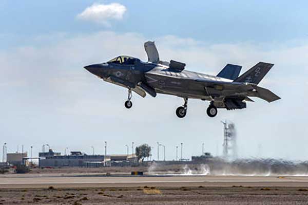
Raytheon’s F-35 precision landing system can be set up anywhere in less than 1.5 hours
A Raytheon Company team has conducted a rapid set-up demonstration of a land-based expeditionary version of its Joint Precision Approach and Landing System (JPALS) to a group of global military officials at Naval Air Station Patuxent River, Maryland.
JPALS is a GPS-based precision landing system that guides aircraft to precision landings in all weather and surfaces conditions.
“The entire system was fully operational in 70 minutes on Day One and 50 minutes on Day Two,” said Matt Gilligan, vice president at Raytheon’s Intelligence, Information and Services business. “Raytheon is offering the U.S. and its allies fast and accurate precision landing systems that support operations from bare-base locations.”
During the demonstration, military officials from all four services, as well as representatives from Japan, United Kingdom, The Netherlands and Italy, watched multiple F-35Cs land on the same designated runway landing point every time over the course of six different approaches.
This was the second proof-of-concept event in 2019 showing how F-35s can use a reconfigured mobile version of JPALS to support landings in austere environments.
JPALS is a differential, GPS-based precision landing system that guides aircraft onto carriers and amphibious assault ships in all weather and surface conditions up to the rough waters of Sea State 5. It uses an encrypted, jam-proof data link to connect to software and receiver hardware on the aircraft and an array of GPS sensors, mast-mounted antennas and shipboard equipment.
A Raytheon technician operates the rapidly installed JPALS equipment during a demonstration at the Naval Air Station. (Photo: Raytheon)
Talen-X has joined Orolia Defense & Security to expand its capabilities and resources, enabling the development of more advanced position, navigation and timing (PNT) solutions and to offer more robust customer support.
Orolia Defense & Security has completed the acquisition of Talen-X, a U.S. company specializing in advanced GNSS solutions and interference, detection and mitigation (IDM) technologies.
“Orolia Defense & Security is excited to bring on Talen-X as they offer a complementary portfolio of solutions and bring many years of advanced PNT experience to the team. We look forward to continuing their growth by providing additional resources and capabilities, while ensuring the growth and success of their current customers,” said Hironori Sasaki, president of Orolia Defense & Security.
In early 2019, Orolia Defense & Security spun off as a separate entity from its parent company Orolia, with the mission of providing resilient PNT solutions and custom engineering services to U.S. government agencies, U.S. defense organizations, and their contractors.
Orolia Defense & Security operates as a proxy-regulated company, free of foreign ownership, control or influence (FOCI). As such, Orolia Defense & Security is approved to work on the full spectrum of U.S. government classified and unclassified projects and is positioned to support strategic partnerships in the development of key PNT technologies for the defense market.
“Our culture of innovation, together with our demonstrated testing capabilities, will complement Orolia’s technology expertise and significantly enhance the reliability, performance and safety of military operations,” said Tim Erbes, Orolia Defense & Security’s Director of Engineering. The acquisition also enables Talen-X’s existing resources, operations and capabilities to be scaled and accelerated to better support the warfighter.
At the Modern Day Marine and Association of the U.S. Army (AUSA) exhibitions, Orolia Defense & Security is showcasing its latest technologies such as the BroadSim Wavefront GNSS simulator, ThreatBlocker jamming/spoofing detection and protection device and BroadShield threat detection software.
Authorized for use with U.S. military signals such as GPS L1/L2, P, Y, and M-Code, Orolia’s simulation and IDM solutions serve unique and challenging program requirements.
Remotely controlled Javelin firings can help keep soldiers out of harm’s way. (Photo: Lockheed Martin)
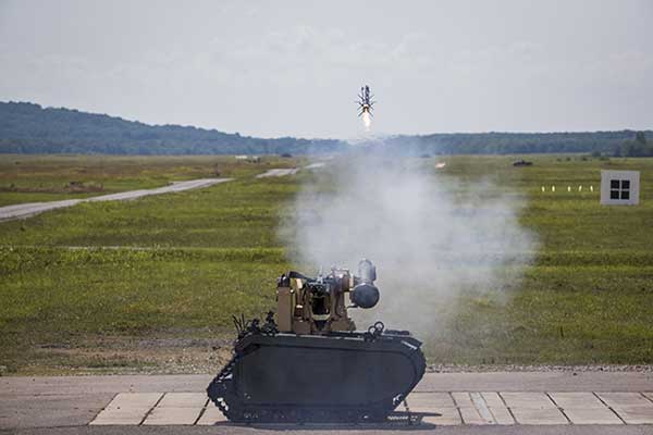
The Javelin Joint Venture team, a partnership of Raytheon Company and Lockheed Martin, successfully fired Javelin missiles from a Kongsberg remote launcher mounted on a Titan unmanned ground vehicle built by QinetiQ North America and Milrem Robotics.
The demonstrations, conducted at the U.S. Army Redstone Test Center, Alabama, validated the integration of the weapon station, missile and vehicle.
“Javelin is ready to support emerging military robotic vehicle requirements,” said Sam Deneke, Raytheon Land Warfare Systems vice president. “Remotely operated technology like this protects soldiers in battle.”
Javelin has been fielded on the Common Remote Operations Weapon Station-Javelin across U.S. Army Stryker 8×8 vehicle brigades in Europe.
“Javelin offers true fire-and-forget engagements to 4 kilometers in most operational conditions,” said David Pantano, Javelin Joint Venture vice president and Lockheed Martin Javelin program director. “Once the launch command is issued, soldiers and vehicle assets like the UGV can reposition out of harm’s way. These tests demonstrated our ability to evolve Javelin capabilities to address new missions in support of the warfighter.”
Javelin is a versatile one-man-portable and platform-employed anti-tank and multi-target precision weapon system. The Javelin Joint Venture team has produced more than 45,000 Javelin missiles and 12,000 command launch units. The program continually updates the system to stay ahead of advancing threats, including enhancing its platform-mounted capabilities.
U.S. and coalition forces have used Javelin extensively in Afghanistan and Iraq in more than 5,000 engagements.
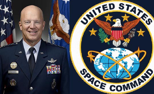
U.S. Space Command Commander General John W. “Jay” Raymond, in his first official directives, established two subordinate commands that will jointly provide support to the new Unified Combatant Command.
Combined Force Space Component Command and Joint Task Force Space Defense will focus the planning and execution of global space operations, activities and missions into two areas:
protection and defense from threats to U.S. space capabilities/forces and
maintaining and growing our national security space programs, combat-relevant space capabilities, and space cadre talent to increase warfighter lethality.
“To ensure USSPACECOM can conduct its mission decisively, I am establishing two subordinate commands with distinct and defined mission areas to ensure the command is postured to protect and defend, while also increasing joint warfighter lethality and strengthening partnerships,” Raymond said.
“The establishment of the Department of Defense’s 11th COCOM dedicated to space operations reflects the value of space contributions to national security, the evolution of the threats to U.S. space systems, and the importance of deterring potential adversaries from challenging or attacking U.S. space systems. These subordinate commands will have a direct impact on that mission,” he said.
JTF-SD
The JTF-SD will be commanded by Brigadier General Thomas L. James, with a mission to conduct space superiority operations in unified action with mission partners to deter aggression, defend space capability and, when directed, defeat adversaries throughout the continuum of conflict.
The JTF-SD will execute its protect and defend mission through various operations centers, including National Space Defense Center at Schriever Air Force Base, Colorado; Space Situational Awareness Units; and Emerging Space Defense Units.
CFSCC
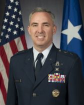
Maj. Gen. Stephen N. Whiting. (Photo: USAF)
The CFSCC will be commanded by Major General Stephen Whiting with a mission to plan, integrate, conduct and assess global space operations in order to deliver combat-relevant space capabilities to Combatant Commanders, Coalition partners, the Joint Force, and the Nation. CFSCC plans and executes space operations through four distinct and geographically dispersed operations centers, including:
Combined Space Operations Center at Vandenberg AFB, California;
Missile Warning Center at Cheyenne Mountain Air Force Station, Colorado;
Joint Overhead Persistent Infrared Center at Buckley AFB, Colorado; and
Joint Navigation Warfare Center located at Kirtland AFB, New Mexico.
Additionally, CFSCC executes tactical control over a number of Air Force, Army and Navy space units.
Protecting critical space assets
“Over the past decade, our great power competitors have developed technologies that threaten our critical national assets in space,” Raymond said. “The U.S. has no desire to see a conflict in space, and we are working hard to ensure no country believes they can gain a terrestrial advantage by extending a conflict to space.
“It’s important to understand that, like all nations, we have the inherent right of self-defense, so purposeful interference with space assets vital to our national security will be met by leveraging our multi-domain capabilities across air, land, sea, cyber and space, and all of our instruments of national power.”
In a move to enhance the United States’ space superiority capabilities, the United States Space Command (USSPACECOM) was formally re-established.
USSPACECOM existed from 1985 to 2002 but was absorbed into U.S. Strategic Command in 2002 to make room for U.S. Northern Command and a greater focus on homeland defense.
From establishment to full operational capability, General Raymond will remain dual-hatted as the commander of Air Force Space Command and U.S. Space Command. The GPS constellation is operated by Air Force Space Command’s 50th Space Wing at Schriever Air Force Base east of Colorado Springs.
USSPACECOM will have a temporary headquarters of about 280 people at Peterson Air Force Base, Colorado.
“Establishing USSPACECOM is a critical step that underscores the importance of the space domain and its strategic contributions to U.S. national security,” the U.S. Space Command stated in a news release. “The USSPACECOM establishment will accelerate the United States’ space capabilities to address rapidly evolving threats to U.S. space assets and the importance of deterring potential adversaries from putting critical U.S. space systems at risk.”
“The scope, scale and complexity of today’s threat is real and it is concerning,” said Raymond during the establishment ceremony. “The establishment of a Combatant Command solely focused on the space domain demonstrates the United States’ commitment to protecting and defending its space assets against that threat.”
Emblem of USSPACECOM
The USSPACECOM mission is to deter aggression and conflict, defend U.S. and allied freedom of action, deliver space combat power for the Joint/Combined force, and develop joint warfighters to advance U.S. and allied interests in, from and through the space domain.
The command will be postured to protect and defend, while increasing joint warfighter lethality by executing two primary missions focused on
unifying and leading space capabilities for the Combined Force, and
maintaining U.S. and Allied advantages in space through protection and defense.
USSPACECOM’s global area of responsibility includes the area surrounding the earth at altitudes equal to or greater than 100 kilometers above mean sea level.
The GPS Directorate has approved a change to the Navstar GPS Control Segment to User Support Community Interfaces ICD-GPS-240 and ICD-GPS-870, reports the U.S. Coast Guard Navigation Center.
The change removes the GPS satellite plane/slot and clock information from the Operational Advisory message. SVN/PRN, block type and NANU details will continue to be included.
The change proposal was approved by the GPS Interface Control Working Group in December 2018.
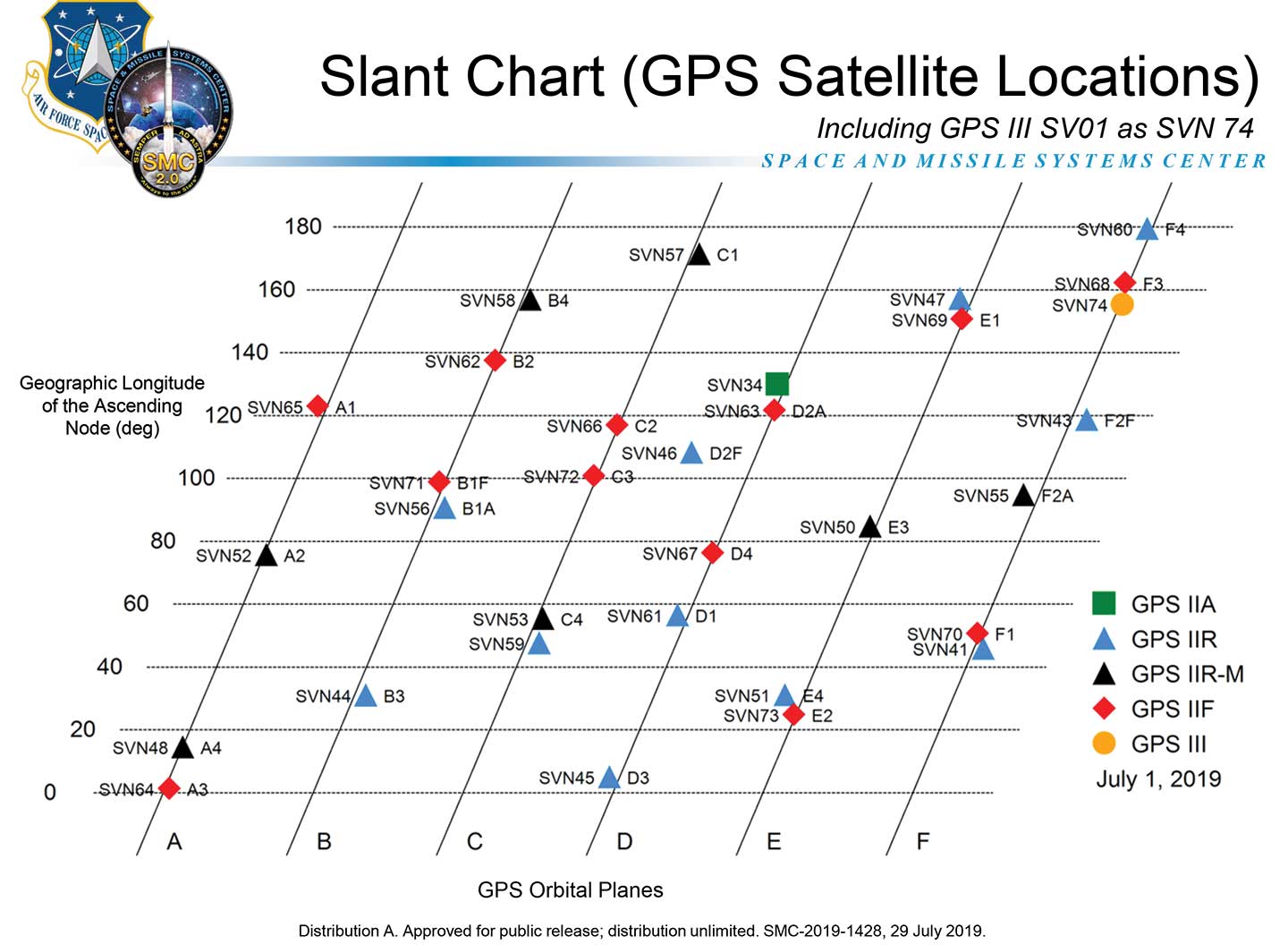
A depiction of the GPS constellation of satellites with slot and plane designations has been published by the U.S. Coast Guard Navigation Center as an easy-to-read graphic for use by the GPS user community.
Chart: NAVCEN
The chart can be found on the NAVCEN Constellation Status page and will be updated with the commissioning of new GPS satellites or upon any change in the constellation.
GPS OCX will maneuver satellite into final orbit over 10 days
The U.S. Air Force used Raytheon Company’s GPS Next-Generation Operational Control System, known as GPS OCX, to support the launch of its second GPS III satellite into space. The ground system will now spend 10 days maneuvering the satellite into its final orbit, demonstrating GPS OCX’s ability to simultaneously support multiple GPS III spacecraft on-orbit throughout the checkout and calibration process.
Raytheon’s GPS OCX has obtained the highest level of cybersecurity protections of any Department of Defense space system.
“GPS OCX performed extremely well during the first launch and has exceeded performance requirements in the months since,” said Dave Wajsgras, president of Raytheon Intelligence, Information and Services. “The team was well-prepared for this launch, and we’re confident the system’s performance will continue to be positive.”
GPS OCX, the enhanced ground control segment of America’s GPS system, has achieved the highest level of cybersecurity protections of any Department of Defense space system. Its open architecture design allows it to integrate advanced protections as they become available, and the system’s industry-leading cyber protections are why it will be used to support all future GPS III launches and GPS constellation operations upon operational acceptance.
Earlier this year, the team completed final qualification testing of the system’s modernized monitor station receivers, which can receive and decrypt all GPS III military and civil signals. Global installation of the receivers starts next month and keeps the program on track for full system delivery by the program’s June 2021 contractual deadline.
In addition to GPS OCX’s role, RGNext, a joint venture between Raytheon and General Dynamics Information Technology, provided operational launch support to ensure the safe launch of the United Launch Alliance’s Delta-IV rocket that was carrying the GPS III satellite. RGNext operates the launch range on behalf of the U.S. Air Force, providing maintenance, range safety, weather monitoring, communication and surveillance support for all launches conducted by defense, civil and commercial companies at the range. To access our press kit, which includes photos, videos and an animation, please visit us here. To learn more about the program’s progress and additional capabilities, visit us here.
New technology makes GPS more secure and reliable for military systems.
Raytheon has received security certification for new GPS modules and receivers from the GPS Directorate at the U.S. Air Force Space and Missile Systems Center.
The new modules and receivers will give military aircraft, ships, ground vehicles and weapon systems secure and reliable access to modernized GPS.
“Because GPS is under constant attack, we worked with our government partners to create new M-code modules and receivers that give the military secure and resilient navigation systems,” said Eric Ditmars, vice president of Raytheon’s Secure Sensor Solutions. “And since the tech is platform agnostic, it will work on a wide-range of platforms in the air, on the ground or at sea.”
Raytheon’s military code common GPS module was certified, along with its ground-based GPS receiver, or GB-GRAM, and the avionics GPS receiver, or GRAM-S/M. GB-GRAM and GRAM S/M are jointly developed with Trimble, while General Dynamics provides cryptographic capabilities for the modules.
“Operators need a system that is flexible and fast,” said Chad Pillsbury, director of Resilient Navigation at Raytheon Space and Airborne Systems. “We’ve designed these GPS systems with a common security architecture — meaning we can get this capability in the hands of operators faster and eliminate the need for additional security certifications.”
News from the U.S. Army Space and Missile Defense Command/Army Forces Strategic Command
The secretary of the United States Army has designated the U.S. Army Space and Missile Defense Command/Army Forces Strategic Command as the Army’s representative to identify and advocate for positioning, navigation and timing (PNT) information as well as establish and formalize joint navigation warfare, or NAVWAR, requirements.
“Navigation warfare is really about taking a look at different position, navigation, and timing signals and figuring out how the signals flow; the potential for adversaries to disrupt our ability to use them in the future; and how can we not only protect ourselves from the enemy denying us with those abilities, but also how can we do the same to our enemies and affect them and disrupt them in a multi-domain operational environment,” said Col. Timothy G. Dalton, USASMDC/ARSTRAT U.S. Army Training and Doctrine Command, or TRADOC, Capabilities Manager for Space and High Altitude, or TCM SHA.
Soldiers in the field learn how to operate in a NAVWAR environment. (Photo: U.S. Army)
What NAVWAR Does. NAVWAR allows the Army to take deliberate defensive and offensive actions to assure U.S. forces PNT information through coordinated employment of space, cyberspace and electronic warfare operations. PNT data enables the Army to precisely move, shoot and communicate; extend its operational reach; control the tempo of operations; and perform mission command, all without adversarial interruption.
NAVWAR capabilities include electronic protection which includes systems and capabilities required to defend platforms and systems against electronic acts in the GNSS electromagnetic spectrum.
The Army has more than 250,000 GPS-dependent systems.
Additionally NAVWAR provides electronic support to sensors and software used to search for, intercept, identify, locate or localize, and report sources of intentional and unintentional radiated GNSS electromagnetic interference for mitigation and planning future operations.
NAVWAR can also provide electronic attack with capabilities to seize and sustain the initiative by actively degrading or denying the GNSS electromagnetic spectrum to adversaries in multi-domain operations.
The Army is dependent on the use of this data with a typical brigade combat team depending on more than 28 different systems and 600 total systems that leverage PNT. The Army has more than 250,000 GPS-dependent systems.
“As the Army goes forward in multi-domain operations, what we see the battlefield becoming is a contested environment,” Dalton said. “What that means is there are adversaries that will look to challenge the United States across all operational phases and domains. These enemies will have the capability to disrupt signals, like GPS, that can impact a wide range of military and civilian activities.
New NAVWAR Concept. SMDC is developing a TRADOC-sponsored Army NAVWAR concept that will be used to establish a baseline for how the Army will execute the NAVWAR fight.
The Army is highly dependent on the use of GPS-delivered PNT data. NAVWAR prevents the use of GPS by hostile forces while ensuring unimpeded use for U.S. forces and allies.
“In the command’s advocacy role we work with the joint and Army communities to examine what the Army needs to be able to accomplish the mission through navigational warfare,” Dalton said. “We work with a community of interest to determine the requirements that will build capability and reduce shortfalls in this mission area.
“This includes activities like updating doctrine, our organizational structure, ability to train the force, and ultimately determine if we need additional equipment, or holistic solutions to protect capabilities and disrupt the enemy on the navigation warfare side,” he added.
Training and Research. SMDC, in conjunction with U.S. Forces Command and the Joint Navigation Warfare Center, supports training events under degraded GPS conditions. The goal is to enable tactical formations to develop and train tactics, techniques and procedures that enable Army formations to work.
“We help develop and focus the capability requirements for the Army,” Dalton said. “But we are integrating with a larger community, led by the Assured Positioning, Navigation and Timing Cross-Functional Team that is focused on modernizing the Army in this mission area.”
SMDC is the Army lead for institutional unity of effort on NAVWAR with several research, development, test and evaluation and capability integration efforts working on the issue independent of one another.
“It is definitely an exciting time for NAVWAR,” Dalton said. “The Army, services and Department of Defense, as a whole, have started to embrace the importance of this mission area and understand the competitive advantage the U.S. and our partners can gain while denying the adversary the ability to conduct operations with respect to navigational warfare.”
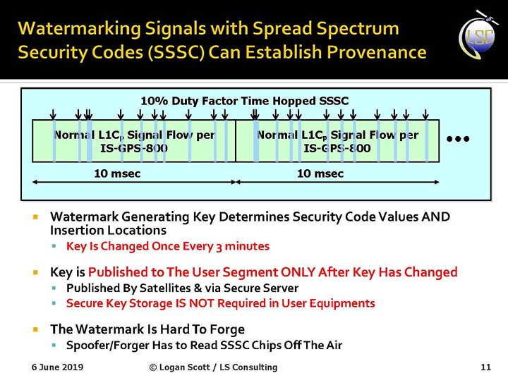
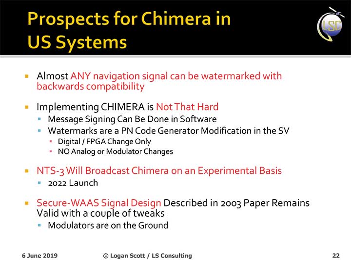
The U.S. Air Force will load a new signal feature, designed to make spoofing detectable, aboard a satellite that will broadcast it from space as a security overlay for the GPS L1C signal, but not until 2022 at the earliest.
The Chips Message Robust Authentication (Chimera) is now in testing under the auspices of the Air Force Research Laboratory (AFRL), getting ready to fly on the Navigation Technology Satellite 3 (NTS-3), which will trial a number of new PNT techniques and technologies.
Chimera inserts encrypted digital signatures and watermarks within the L1C signal. A GPS receiver with the requisite additional capability for this purpose can then detect whether the signal is real or fake and also authenticate the location of a GPS receiver that is remotely located.
This key feature could provide a defense against hacking by blocking access from anyone unable to prove they are at an anticipated or licensed site. Hacking, of course, is a growing threat to all sorts of infrastructure: financial, security, utility grid and more.
Presentation slide from PNT Advisory Board briefing by Logan Scott.
Consultant Logan Scott first proposed the Chimera technology in 2003, when he affirmed that “Some of the spoofing detection measures in wide use offer a false sense of security. Authenticatable signal architectures are needed.” In June, he made a presentation to the PNT Advisory Board: “The Role of Civil Signal Authentication in Trustable Systems.” The two slides accompanying this article appeared in that presentation.
“Chimera represents a fundamental paradigm shift in PVT security paradigms,” Scott related in a subsequent conversation. “Trust takes time and memory on a personal level and, in this case, in GNSS signals, too.
“You don’t trust somebody as soon as you meet them. Over a period of time, you get to know them. If you can’t remember anything, you can’t develop trust either.”
“In the GNSS world, there are a lot of applications where you don’t need output in real time,” Scott said. “For example, to align an inertial. The inertial provides the real-time aspect. You don’t want to send anything to the IMU that is factually incorrect. When building to aid inertial, I can afford to have a delay from real time as long as I tell it where it was 10 seconds ago. The power of that is, if I don’t have to give real-time output, I can ponder and think about things.
“If a spoofer attacks, there’s an evolution that happens there. If I, as the receiver, can see the developing scenario, and how it starts to look at little screwy, I can stop and not send anything to the IMU that might corrupt it.”
How It Works. The core concept of Chimera involves the satellites sending encrypted watermarks, encoded into the signal by the satellite. After a slight delay, the satellite sends the key used to generate those encrypted watermarks. Once a key is sent, the system changes the key.
Since the receiver has already recorded the signal with its watermarks before the key is sent, spoofers cannot know the correct key ahead of time, in time to insert correct watermarks of their own. This means that any spoofed signals can be easily spotted: either the subsequent key won’t match up with the spoofed watermarks, or there will be no watermarks at all.
“Another reason it’s hard for someone to generate these watermarks on their own is because the signal is buried below the noise,” added Scott. “The watermarks are hidden.”
A number of different time delays between signal and key are possible within this concept and within the general set-up of GPS. Scott and the AFRL have, for various practical reasons, provisionally settled on a 6-second delay on the fast watermark channel and a 3-minute delay for the slow watermark channel.
The signal enhancement could be incorporated into the Wide Area Augmentation System (WAAS). This has yet to be fully determined, but this route would lead to a faster implementation of Chimera. Scott thinks that going the WAAS route could bring Chimera capability into action within two years.
The AFRL, however, is looking at a much longer timeline. The NTS-3 satellite, where it first intends to test Chimera, will not launch until 2022 — three years hence. And that’s only a test, not an enactment or a system-wide implementation.
Slide: Logan Scott
Verification. One key benefit for commercial entities, particularly those in financial infrastructure and other systems that increasingly fall victim to hacking, is that Chimera gives them the ability to verify customers’ or partners’ locations before granting any kind of access. The customer’s or other erstwhile user’s GPS receiver would record the full signal, including the watermarks, and transmit that data to the company, entity or data center needing location verification, before the keys are published. Each combination of watermarks and signals is unique to the place where it was recorded, thus it is possible to tell whether the user is actually where they say they are, or in an authorized or pre-identified location before granting access or accepting further input (such as commands).
Scott claims that Chimera affords a 99.9% probability of detecting spoofers. “I have a 99.9% chance of detecting that the watermark is not there, because they don’t know how to generate it. This is based on how you’re processing the signal. It’s designed to be very flexible in how the receiver uses the signal.”
Just One Problem. Receiver manufacturers will have to develop new Chimera-capable receivers, and customers will have to buy them. An additional cost for the added processing, above and beyond that required for normal GPS operation, is unavoidable.
And a Hiccup. Chimera, while an acronym, is as a name perhaps not a totally felicitous choice. In Greek mythology, the chimera is a fire-breathing female monster with a lion’s head, a goat’s body, and a serpent’s tail. These historic ancestors have evolved into the word’s more current use: a thing that is hoped or wished for but that is in fact illusory or impossible to achieve.
AFRL Wants Your Opinion. The Air Force Research Laboratory seeks feedback from the PNT community on the Chimera enhancement for the L1C signal. The specification is here. And, you can download a comment form
SiTime Corp. has unveiled its Endura micro-electro-mechanical system (MEMS) timing solutions for aerospace and defense applications including precision GNSS, as well as field and satellite communications, avionics and space.
The Endura products are engineered to provide high performance in harsh conditions — severe shock, vibration and extreme temperature — that are routinely experienced in these applications.
SiTime offers customers 5 million possible part numbers that can be created from 17 programmable products.
“When exposed to high levels of shock, vibration, and extreme temperatures, legacy timing components have been prone to failure, degrading system performance and reliability,” said Piyush Sevalia, executive vice president of marketing. “To solve these problems, SiTime created an oscillator system of silicon MEMS, analog circuits, compensation algorithms, and advanced packaging, which is designed to outperform any other available timing solution in harsh environments.
“For example, Endura precision TCXOs deliver 4 parts per trillion per g (ppt/g) of acceleration sensitivity, which is 50 times better than legacy quartz-based solutions. With such performance, we believe that Endura will transform the oscillator landscape in aerospace and defense.”
Highlights of the company’s solutions include:
4 parts per trillion per g force of acceleration (50 times better than quartz)
Supports –55 degreesCelsius and +125 degrees Celsius operation
Key timing specifications conform to MIL-PRF-55310
Five million possible part numbers
Endura Super-TCXOs (temperature compensated oscillators) for use in high-speed communications and GNSS applications include:
SiT5146/SiT5147 – 1 to 220 MHz, ±0.5 to ±2.5 ppm, -40 degrees Celsius to +105 degrees Celsius
SiT5346/SiT5347 – 1 to 220 MHz, precision ±0.1 to ±0.25 ppm, -40 degrees Celsius to +105 degrees Celsius
SiT5348/SiT5349 – 1 to 220 MHz, ultra-precision ±0.05 ppm
SiTime’s portfolio of commercial off-the-shelf (COTS) Endura products spans six oscillator types and 17 products. All devices offer programmable options such as frequency, operating voltage and stability.
In addition, some devices offer specialized programmable features such as spread spectrum, pull-range, and differential output type.
Endura products are available with up to two grades of acceleration sensitivity, as low as 4 ppt/g (typical). This breadth of products provides customers with a large selection and the ability to configure each device for their application requirements.
Endura products are also designed for continuity of supply for long-life programs.