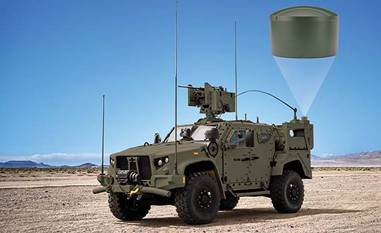
NovAtel has added the GAJT-410ML to its GPS Anti-Jam Technology (GAJT) portfolio. Designed specifically for rapid integration into space-constrained military land applications, the easy-to-use system protects GPS-based navigation and precise timing receivers, including M-code, from both intentional and accidental interference, the company said.
The GAJT-410ML is the next evolution of NovAtel’s battle-proven anti-jam technology. It maintains the high levels of interference rejection performance as in the larger GAJT-710ML system, but in a lower size, weight and power (SWaP) design.
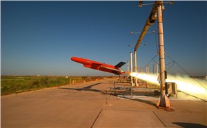
Photo: NovAtel
Working alongside the GAJT-410ML, the Power Injector Data Converter (PIDCTM) provides access to the jammer status and direction-finding (DF) information. It also provides clean power and data over the same cable that delivers the protected GPS signal back to the receiver, which reduces the need for costly platform modifications. The PIDC can be supplied in either an enclosure or board and is available to license for installation into third-party equipment.
NovAtel Defence Segment Manager Dean Kemp noted, “Building on the success of our existing anti-jam portfolio, the GAJT-410ML is the first system to address the needs of smaller land-based platforms and add situational awareness capability to already high levels of mitigation performance.”
“This product offers more choices for system integrators and end users to protect against GPS denied or constrained situations and delivers on our commitment to provide assured positioning anywhere,” Kemp added.
Learn more about the GAJT-410ML anti-jam antenna or talk with NovAtel’s team of specialists at these upcoming trade shows:
The Special Operations Forces Industry Conference (SOFIC) – May 20 – 23, 2019, Tampa, FL USA
CANSEC – May 29 – 30, 2019, Ottawa, ON Canada
Joint Navigation Conference (JNC) – July 8 – 11, 2019, Long Beach, CA USA
International Defence Industry Exhibition MSPO (Canadian Pavilion) – September 3 – 6, 2019, Kielce, Poland
Defence & Security Equipment International (DSEI) – September 10 – 13, 2019, London, UK
Auterion and Impossible Aerospace are collaborating to bring to market the US-1 UAV, which has a two-hour flight time.
Auterion is the provider of Auterion Enterprise PX4, an open-source-based, enterprise operating system for drones. Impossible Aerospace is Silicon Valley, California-based drone manufacturer on a mission to assemble the highest performance electric aircraft.
“During critical public safety incidents, real-time intelligence from a UAV is extremely important. This is why the two-hour flight time of the US-1 is a clear necessity.” said Spencer Gore, CEO of Impossible Aerospace. “We turned to Auterion for software because their operating system is auditable and trusted for government applications.”
“Public safety organizations can now field a drone with government solicited, cyber-secure and trusted software that enables the drone to stream real-time footage to a command center,” said Kevin Sartori, co-founder of Auterion. “Choosing Auterion and its open-source, open-standards approach will greatly simplify the integration of the US-1 into the IT-infrastructure of public safety organizations.”
Thousands of professional drone pilots and businesses around the world count on open-source flight control software PX4, which was created by Auterion co-founder Lorenz Meier in 2011 and has evolved into a global developer community. Similar to Red Hat, Auterion builds the open-source infrastructure so that drone manufacturers can go to market faster with new products flying trusted software.
The US-1 quadcopter made its public safety debut in February with a California-based police force. The drone gives police agencies a new category of assets that sit between lower-end drones and police helicopters. This enables a wider usage of aerial imagery and reduces the cost for first responders at the same time.
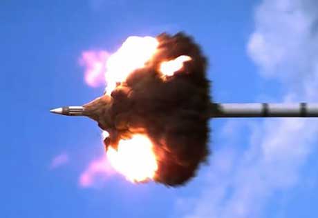
Guided projectiles can provide sailors with precision fires
Raytheon Company and the U.S. Navy completed a new round of successful Excalibur N5 munition test firings at Yuma Proving Ground in Arizona.
Raytheon’s sea-based Excalibur N5 projectile will more than double the maximum range of conventional 5-inch munitions and provide the same accuracy as the land-based version. (Photo: U.S. Department of Defense)
The precision-guided projectiles demonstrated various short-, mid- and long-range capabilities.
Besides satellite navigation, Raytheon’s precision weapon systems incorporate laser guidance, high-definition radars, advanced seekers and other technologies.
Designed to be fired from the Navy’s five-inch guns, Excalibur N5 is the sea-based variant of the extended-range, precision munition used by ground forces around the globe. The Excalibur weapon provides accurate, first-round effects at all ranges in all weather conditions.
“Excalibur N5 answers the Navy’s need for a sea-launched, precision-guided projectile,” said Sam Deneke, Raytheon Land Warfare Systems vice president. “N5 doubles the range of the Navy’s big guns and delivers the same accuracy as the land-based version.”
Excalibur is a true precision weapon, impacting at a radial miss distance of less than two meters from the target. Widely used by U.S. and international artillery forces, Excalibur has been fired more than 1,400 times in combat.
The precision-guided projectile was co-developed by Raytheon Company and BAE Systems Bofors.
Besides N5, Raytheon has developed other variants such as the laser-guided Excalibur S, Excalibur HTK and Excalibur Shaped Charged Trajectory.
DroneShield Ltd. has released a body-worn drone detection product, RfPatrol. Weighing under 1 kilogram, the mobile unit is expected to be of significant interest to a range of DroneShield’s customer base globally, across military, law enforcement, security and VIP markets.
DroneShield made the announcement at AUVSI Exponential 2019, being held this week in Chicago.
RfPatrol is a passive (non-emitting) product, which substantially broadens the range of customers to whom the product is lawfully available. It was developed in response to customer interest.
Already, a small quantity of the RfPatrol units has been ordered by a western country’s defense department, for evaluation with a potential larger order in the future.
“We are excited to launch RfPatrol,” said DroneShield CEO Oleg Vornik. “Due to its miniaturized/body-worn nature, substantially larger customer universe due to its non-emitting nature, and a relatively lower price point compared to fixed-site products, we expect it to have substantial appeal. In addition to being able to be used as a stand-alone, it is a perfect companion to our DroneGun product.”
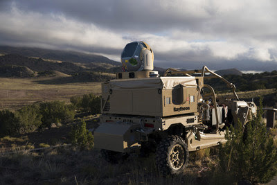
Raytheon Company‘s advanced high-power microwave and mobile high-energy laser systems engaged and defeated multiple unmanned aerial system targets during a U.S. Air Force demonstration. The mature HPM and HEL technologies offer an affordable solution to the growing UAS threat, the company said.
Raytheon made the announcement at AUVSI Xponential, taking place this week in Chicago.
Raytheon’s mobile high energy laser looks out into a wide-open sky. The company’s advanced high-power microwave and high-energy laser engaged and defeated dozens of unmanned aerial system targets in a recent U.S. Air Force demonstration.
The HEL system, paired with Raytheon’s Multi-Spectral Targeting System, uses invisible beams of light to defeat hostile UASs. Mounted on a Polaris MRZR all-terrain vehicle, the system detects, identifies, tracks and engages drones.
“Countering the drone threat requires diverse solutions,” said Stefan Baur, Raytheon Electronic Warfare Systems vice president. “HEL and HPM give frontline operators options for protecting critical infrastructure, convoys and personnel.”
Raytheon’s HPM uses microwave energy to disrupt drone guidance systems. High-power microwave operators can focus the beam to target and instantly defeat drone swarms. With a consistent power supply, an HPM system can provide virtually unlimited protection.
“After decades of research and investment, we believe these advanced directed energy applications will soon be ready for the battlefield to help protect people, assets and infrastructure,” said Thomas Bussing, Raytheon Advanced Missile Systems vice president.
Raytheon’s HEL and HPM were the only directed energy systems that participated in this Air Force experimentation demonstration. The event expanded on previous directed energy demonstrations such as a U.S. Army directed energy exercise held in 2017.
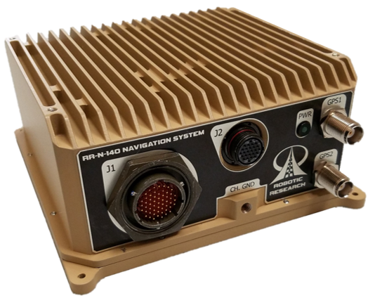
The system provides accurate, absolute and relative 3D (six-degrees-of-freedom, or 6 DOF) localization information for ground vehicles of all sizes.
The device delivers exceptional localization performance in GPS‐denied or compromised areas. It is designed specifically for use on unmanned ground vehicles and is heavily customizable to incorporate a wide variety of sensor inputs into the navigation solution.
Robotic Research develops and deploys autonomous vehicle innovations for both commercial and government customers.
Features of the RR-N-140 include:
Accurate, real-time navigation/localization solution for wheeled or tracked ground vehicles
Adaptable for use on surface vessels
Exceptional localization performance in GPS-denied or compromised areas
Dual antenna GNSS for zero-speed heading detection and redundancy
Rugged IP67 Construction designed to meet shock and vibration environments typical of military vehicles
Up to 4X configurable vehicle speed / encoder inputs
Configurable GNSS and IMU options allow tailored solutions for all levels of performance
Customizable to directly interface with and process a variety of sensor inputs (e.g. LADAR, Stereo and Monocular Cameras, Ultra-Wideband Ranging Radios)
Easy integration with the Robotic Research Warfighter Localization family of systems (WarLoc)
Web interface for user-level diagnostics and configuration
Ethernet, CANbus, and RS-232 Serial Data Interfaces
Independent Ethernet ports for separation of navigation solution and sensor processing data
Robust Built-in-test (BIT) error reporting during runtime
Redundant IMU and GNSS options available for fault-tolerance
NTP Server and GPS PPS signals for time synchronization
Photo: U.S. Air Force / Staff Sgt. Scott H. Spitzer
Much development has been necessary to enable the new M-code capability on more than 700 weapon systems that require it. This article overviews M-code, the updates to antenna and receiver technology to make these varied platforms M-code ready, and perspectives from key stakeholders in the M-code community.
December 23, 2018, marked an important milestone for GPS. The successful launch of satellite USA-289 represented a key success in what has been a monumentally expensive government program, beset by delays and overspends.
The launch of the first GPS Block III satellite, the first that can provide the full military M-code capability, effectively commenced the physical roll-out of modern M-code hardware.
Ground Control. As far as the space segment is concerned, M-code is finally underway. What about the ground segment? The next-generation GPS operational control system, GPS OCX, is essential for use of the full capabilities of the new Block III satellites. It has been under development for some time.
OCX has drawn Congressional criticism and correlative media attention, but recent reports have been more positive. Since the Nunn-McCurdy breach of 2016, when the project’s future hung in the balance, accounts have grown gradually optimistic. Budget and schedule were re-baselined, and contractor Raytheon’s corrective actions generated results. In the fall of 2017 the Air Force took delivery of OCX Block 0, marking a significant milestone. Block 0, also known as the Launch and Checkout System (LCS), demonstrated compliance with contractual requirements and was accepted by the Air Force.
In spring 2018, Block 0 underwent a series of cybersecurity tests and passed, validating the security architecture of the system. All this puts Raytheon on track to deliver OCX Block 1 in 2021, providing full operational capability. Block 1 and Block 2 are intended to be delivered together, adding operational control of the modernized satellites and signals, including L1C and the modernized M-code.
“There have been no schedule slips with the GPS OCX program since 2017, and the GPS III launch last December was clear proof of our progress,” stated Dave Wajsgras, president of Raytheon’s Intelligence, Information and Services business. “We will continue to meet all of our commitments, and importantly, we will meet our June 2021 contractual deadline.”
Col. Steve Whitney of the GPS Directorate wrote in this magazine in December 2018 that “The journey over the past few years has been challenging, but we have emerged stronger, armed with better metrics, and a culture of integrated development (often called DevOps) which puts us on a path to success. There will be challenges and risks in the path ahead but rather than mountains to climb, I see these more as standard blocking and tackling of a software-intensive program.”
Meanwhile. The Air Force plans to deploy M-code capability in 2020, and OCX seems unlikely to be ready. For this reason, Lockheed Martin was awarded a contract to modernize the existing ground infrastructure as a “gap filler.”
The GPS Control Segment Sustainment II (GCS II) contract was awarded on Dec. 21, 2018, and is worth $462 million. GCS II will support operational capability of M-code in 2020, and continues until 2025, and so there will be a period of overlap between GCS II and OCX, essentially providing two options for controlling the new GPS III constellation. In one view, the Air Force is backing two horses to improve chance of winning: OCX the preferred solution, with GCS II almost like an insurance policy.
With the GPS III ground and space segments looking relatively healthy, attention turns again to the user segment.
WHY M-CODE?
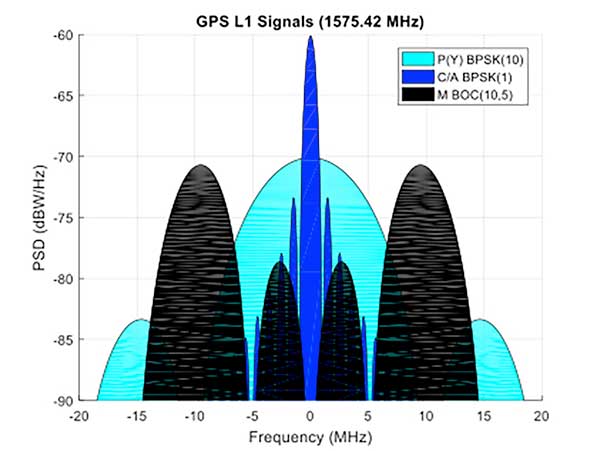
Until now, the military has used the classic P(Y) signal: a binary phase shift keying (BPSK)-modulated encrypted wideband signal. It offers both greater accuracy and increased jamming resistance when compared to the civilian C/A code still employed by the vast majority of GPS receivers.
But the P(Y) code has its drawbacks in the modern world: its wide main lobe sits directly over the top of the C/A code signal (see Figure 1), essentially occupying the same spectrum. When the civilian C/A signal is jammed, the military P(Y) signal is at the very least degraded, if not also jammed itself. It also uses a relatively simple encryption scheme that does not meet today’s cyber security requirements.
Figure 1. C/A, P(Y), and M-Code signal power spectra. (Graphics: Mike Jones)
The M-code signal, on the other hand, is the first military GPS signal to use the BOC modulation scheme. BOC modulation gives signals their distinctive two-lobe appearance, spreading the signal’s energy away from the band center.
The wide spacing of the two sidebands separates the M-code signal from the civilian signals (the legacy C/A signal or the new L1C signal on the L1 frequency, and the L2C signal on the L2 frequency).
Amongst other things, this allows the military to jam the civilian codes without noticeably degrading the M-code signal. Often referred to as blue force electronic attack (BFEA), this is essentially a new facet to navigation warfare (NAVWAR), where enemy use of GPS can be denied whilst allowing friendly forces to continue using it.
The wider occupied bandwidth and increased signal power also help to make M-code more resistant to jamming. M-code also makes use of more modern and flexible encryption methods, ensuring it will be secure and safer from threats such as spoofing attacks.
Scepticism. Defense programs are known for their long procurement cycles, but even by these standards, M-code has taken an extremely long time to get where it is today. Given the enormous cost of the program, and the fact that there is still, as yet, no operational benefit to show from it, many people have questioned its worth. At the time it was conceived it represented a dramatic step forward in military capability but, because it has been so long in development, its operational benefit is becoming diluted.
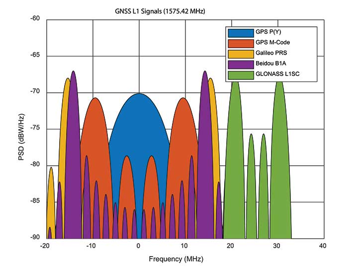
When M-code was conceived, GPS was still the only operational GNSS in town: everybody had to use GPS — or nothing. Today, the picture differs greatly. During M-code’s insanely slow progress, other GNSS systems have come along, offering their own encrypted signals of a similar ilk. Looking at Figure 2, M-code no longer appears as special as it once was. Its BOC(10,5) signal sits inside the main lobes of Europe’s Galileo PRS signal, which uses a BOC(15,2.5) scheme, and China’s Beidou B1A signal using BOC(14,2).
Figure 2. GNSS encrypted signals around the L1 frequency. (Graphics: Mike Jones)
If you were China, you might consider jamming the central 24 MHz of the L1 band, taking out M-code, whilst still having an operational military service for yourself. Or if you were Russia, you might jam 34 MHz of bandwidth, taking out the US, Chinese, and European systems, whilst still having your GLONASS L1SC military service to use. The situation is more complex than that, of course: each service has the potential to increase signal power in times of conflict, and there is more than one frequency that can be used. But it does demonstrate the essence of the problem: The modern battlespace has moved on, and M-code hasn’t.
CHALLENGES OF RECEIVER DESIGN
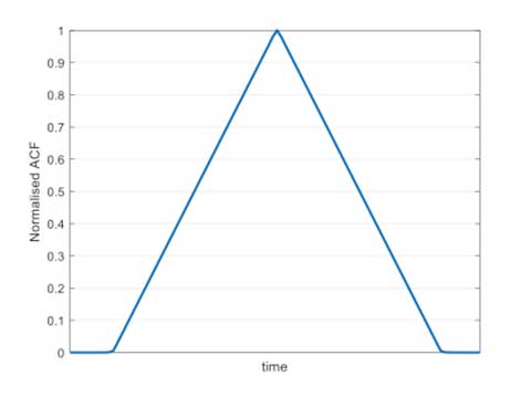
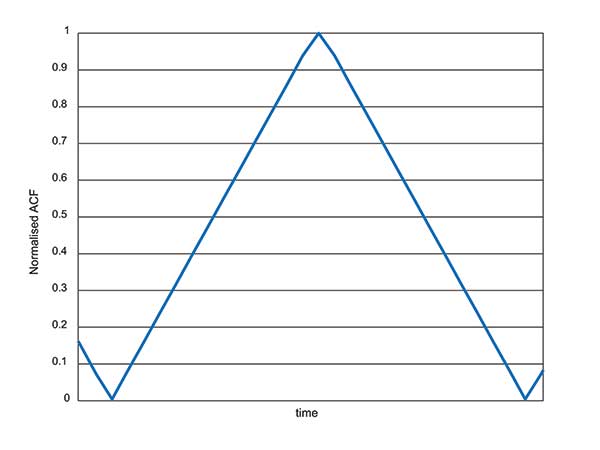
Figure 3. C/A code ACF.
With complex signals come complex receivers, and there several headaches when it comes to M-code receiver design. The first is the nature of the BOC signal itself, which has a complex correlation function. Consider Figure 3, which shows the autocorrelation function (ACF) of the traditional civilian C/A code signal. The single peak of the function makes acquisition and tracking a simple process; traditionally early, prompt and late (E,P,L) correlator arms can be used in the tracking process.
Figure 4. L1Cd ACF.
The newer BOC-type signals have a more complex ACF. Figure 4 shows the ACF of the new L1Cd civilian GPS signal, which uses a form of BOS(1,1) modulation. In addition to the main lobe, there are now two side lobes. Receivers must be careful not to lock on to one of the side lobes instead of the main lobe: the receiver architecture starts to become a little more complex.
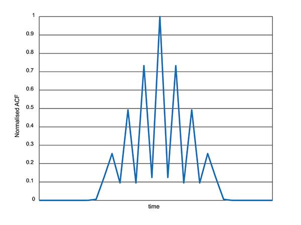
Figure 5. M-code ACF.
Now consider the ACF of the M-code signal, shown in Figure 5. Like other high-order BOC-type signals, M-code exhibits multiple lobes in the ACF, making robust acquisition and tracking a far more troublesome process. Furthermore, the high bandwidths require high sample rates, which lead to higher power consumption in the hardware.
Another major headache associated with M-code receivers is, of course, the encryption process. Not because encryption is difficult, but again because of the power consumption implications. Consider that each GPS receiver needs to run an encryption engine instance, for each satellite it might wish to receive. Running a high-grade encryption algorithm at a high chipping rate, for a dozen satellites, is a power-consuming process. For dismounted soldiers with limited battery capacity, this is a big deal.
Some people argue that the high-grade encryption process for M-code is too complex. Consider why we want to encrypt a GNSS signal in the first place: firstly to prevent someone from spoofing our signal, and secondly to prevent unauthorised users from using the service. Given that the encryption keys are rolled regularly, how much does it matter if an adversary manages to compromise the encryption? This isn’t a communications security problem: we are not talking about loss of classified information, so there’s an argument that a simpler, less power-hungry form of encryption might have been used instead.
ANTI-JAM ANTENNA COMPATIBILITY
Although M-code offers a certain level of jamming resistance, it is still vulnerable to attacks. As a signal it might have a bit more power, and a bit more bandwidth, than some other signals. But it is, after all, still a GNSS signal, and it can be jammed by an adversary. Where an operational threat analysis indicates that an increased level of jamming resistance is required, then M-code receivers need to be integrated with anti-jam antennas.
Anti-jam antennas, usually referred to in the GNSS community as controlled reception pattern antennas (CRPAs), have been the anti-jam tool of choice for several decades now. I overviewed these in an April 2017 newsletter column. CRPA manufacturers have had to ensure that their products are “M-code ready,” such that they can be seamlessly attached to M-code receivers as and when they appear.
This hasn’t been a recent process: as far back as 2002, the GAS-1 antenna (Raytheon) underwent a series of qualification tests to ensure compliance with M-code. Around 2005, the ADAP antenna (also Raytheon) was launched with a host of M-code features — again an illustration of just how slow the M-code program has moved, given that other technology has been “M-code ready” for 10 or 15 years already.
What’s involved in making a CRPA M-code compatible? Firstly the increased bandwidth: the antenna electronics must digitize the wider bandwidths. Along with the wider bandwidth comes new filtering shapes to ensure optimum performance.
Space-time adaptive processing (STAP) and space-frequency adaptive processing (SFAP) techniques potentially require more taps to ensure high null depths can be maintained across the full bandwidth. The increased power of the M-code signal, particularly if features like spot beam are used, presents another complication to CRPAs: they must not treat the high-power satellite signals as jammers, and try to remove them.
Testing CRPAs presents a challenge to manufacturers: how do you prove that your antenna doesn’t corrupt the M-code signal, when there’s no M-code signal to test it with? To work around this issue, pseudo M-code signals have been used for testing, where representative BOC(10,5) signals without the real encryption are passed through the CRPA and examined for distortion.
RECEIVER DEVELOPMENT STATUS
Due to the security considerations surrounding M-code, only three US organizations are authorized to produce modules: Collins Aerospace, Raytheon and L3. Here are the answers from Collins Aerospace and L3, the answers from Raytheon will appear in later issue.
What are the technical challenges associated with developing an M-code receiver?
Collins Aerospace. The Collins Aerospace Modernized GPS User Equipment (MGUE) Increment 1 development like the SAASM PPS receiver developments faced very challenging technical requirements to support our war fighter needs in an ever-evolving threat environment. Like other complex developments the challenges are initially technical and then transition to integration/test and certification. On the technical front optimizing receiver performance balanced against power consumption are always at the forefront. In addition, it is important to maximize backwards compatibility so as to minimize downstream integration costs while adding an entirely new signal that runs in parallel to the existing system. Collins Aerospace is pleased with the technical development and are actively supporting the integration with both receivers and technical support.
To date, we have delivered more than 770 MGUE receivers to the Air Force to support Air Force, lead platform and DoD-wide Integration and test. Soon the total will grow to nearly 1,100 receivers to support expanded integration and test following the completion of Collins Aerospace security certification.
L3. M-code GPS User Equipment (MGUE) technologies exist today.L3’s Ground Based GPS Receiver Application Module – Modernized (GB-GRAM-M) is a fully-functioning unit that is currently baselined and undergoing an independent Technical Requirements Verification (TRV) by the GPS Directorate.During TRV, each requirement from the Technical Requirements Document (TRD) is independently evaluated for compliance. Upon completion of the TRV, the design is baselined with complete documentation enabling platforms and prime equipment to integrate from a known baseline with low risk. Following integration, operational testing can start immediately to support fielding when M-Code Early Use (MCEU) becomes operational. The TRV of L3’s GB-GRAM-M is planned to be completed by the second quarter of 2019.
L3 resolved numerous technical challenges in developing M-code GPS technologies. The first and ever-present challenge is changing and evolving requirements. Most of these requirement changes are in response to evolving threats that have driven changes into the GPS receiver and/or to higher-level systems. Asan example, the U.S. Army’s Assured PNT (A-PNT) is implementing M- code GPS along with external sensors to establish and maintain an assured solution even in GPS-challenged environments. Other challenging requirements include meeting the security requirements, implementing and testing anti-spoofing algorithms, and ensuring backward compatibility with legacy receivers.
What are the intended platforms for your MGUE?
Collins Aerospace. The Collins Aerospace MGUE receivers are intended to support all warfighter domains: ground, airborne, maritime and munitions to support compliance with Public Law 111-383 SEC. 913 issued in Fiscal Year 2011. Per this directive, M-code is intended for all DoD applications with the exception of passenger vehicles or commercial vehicles with GPS installed. Now that the satellite and control segments of the capability are coming on line, we are working diligently to ensure that user equipment is available for all domains.
L3. L3 has products to meet current market demand. Under the MGUE program, L3 developed a GB-GRAM-M, which is a standard Modular Open Systems Architecture (MOSA) design. The GB-GRAM-M is designed to fulfill retrofit replacements of SAASM receivers, as well as being a primary component of A-PNT systems. L3’s M2GRAM ASIC is the core of our receiver, a GPS module that incorporates signal processing, cryptography, and positioning, velocity, and timing (PVT) processing. The M2GRAM ASIC is capable of being implemented in other form factors for applications beyond ground-based applications. As an example, the M2GRAM is implemented in a GPS receiver specifically designed for Precision Guided Munitions (PGM) applications and was used in a gun launched, guide-to-target demonstration operating as a PGM receiver.
L3 is also augmenting the GPS receiver through the integration of several other technologies, including controlled reception pattern antennas with digital antenna electronics, inertial systems and external sensors, and GPS-denied capabilities. M-code technologies are being implemented in Mounted A-PNT Systems (MAPS), Dismounted A-PNT Systems (DAPS), and handheld systems to bring capabilities to the warfighter.
What is the expected timeline for your MGUE development, acceptance testing, and delivery?
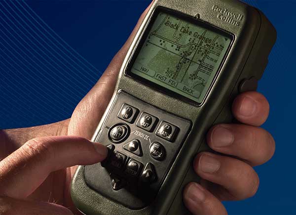
Defense Advanced GPs Receiver (DAGR) from Collins Aerospace, equipping infantry and other warfighters. (Photo: Collins Aerospace)
Collins Aerospace. The Collins Aerospace receivers are supporting ongoing DoD integration and test and our MGUE Increment 1 program is aligned with the Air Force GPS Enterprise roadmap. Ultimately, the Department of Defense (DoD) M-code programs will set the production delivery schedules.
We anticipate that the M-code production ramp-up and continued SAASM PPS receiver production will have a production overlap. Our Collins Aerospace in-house PPS GPS receiver manufacturing capability is ready to support the DoD demand for both M-code and SAASM. Collins Aerospace is fully committed to manufacturing Increment 1 M-code receivers to meet the warfighter’s needs across Airborne, Weapons and Ground, we know the transition from SAASM to M-code will take years. Therefore, Collins Aerospace will continue to manufacture SAASM receivers for years to come as the International MOD Policy for M-code use is still being formulated.
L3. L3’s GB-GRAM-M is now available. L3 received security certification and approval in 2016 and TRV is planned for completion in the second quarter of 2019. With TRV, L3 is receiving a new security certification and approval of the latest receiver update. Government agencies, prime contractors and laboratories can order GB-GRAM-M now with delivery in the fourth quarter of 2019.
What does testing and verification process involve?
Collins Aerospace. As with any Precise Positioning Service (PPS) GPS development, the testing involves functional verification of the receiver in a wide variety challenging of environmental, thermal, electromagnetic interference/ high-intensity radiated field (EMI/HIRF) environments. Collins Aerospace is leveraging proven test and verification approaches founded upon our long history of successful product introductions and field performance. As this is a PPS receiver it is also essential the receiver design comply with the government’s required Security Approval process.
L3. The testing and verification of L3’s GB-GRAM-M included internal testing and independent testing through the GPS Directorate’s TRV process. Further risk reduction testing within the MGUE program is planned as Phase IV testing where the GB-GRAM-M is integrated into a lead platform for the U.S. Army and a lead platform for the U. S. Marine Corps. An operational assessment is performed on both lead platforms to assure common problems associated with integration and operational testing are addressed prior to implementing M-Code GPS Receivers across all of the platforms.
Will the MGUE be compatible with CRPA anti-jam antennas; are there any special considerations for this?
Collins Aerospace. The Collins Aerospace product family includes our Digital Integrated Anti Jam Receiver (DIGAR) product family that leverages CRPA anti-jam antennas for enhanced anti-jam (AJ) performance. Our DIGAR AJ technology enhances the performance with fixed reception pattern antenna (FRPA), CRPA and is compatible with all PPS waveforms. Regarding the interfaces between the receiver and the anti-jam antenna electronics, a GPS receiver with a standard RF interface is compatible with a CRPA in nulling mode and FRPA antennas. Advanced capabilities such as beamforming/beamsteering require tight coordination and additional interface with the GPS receiver.
L3. The GB-GRAM-M is designed to operate with a fixed reception pattern antenna (FRPA). A CRPA antenna using digital antenna electronics to generate signals matching the characteristics of a FRPA is fully compatible with the GB-GRAM-M. With a higher level of integration of a GPS receiver and a CRPA, the system capabilities are greatly enhanced. L3 has performed this integration and can perform advanced capabilities such as angle of arrival and beamforming using M2GRAM, digital antenna electronics, and CRPA technologies. These capabilities can be found in L3’s Mounted Assured PNT System (MAPS) and Anti-Jam Antenna System (AJAS) products.
Army Stryker ground combat vehicle. (Photo: Karolis Kavolelis / Shutterstock.com)
OPERATIONAL DEPLOYMENT
The U.S. Air Force GPS Directorate provided answers to the following questions regarding MGUE.
Which platforms will be equipped with M-code-capable MGUE, and how many of each?
GPS Directorate. The Air Force is developing M-code-capable GPS receivers under the MGUE Increment 1 program. The receivers in development will be provided to four service-specific lead platforms for integration, developmental, and operational testing. Lead platforms are:
the Army Stryker ground combat vehicle,
the Air Force B-2 Spirit bomber,
the Marine Corps Joint Light Tactical Vehicle (JLTV),
and the Navy Arleigh-Burke class destroyer (DDG).
Following the lead platform efforts, procurement of M-code-capable GPS receivers will be decided by the Services and executed by individual platforms and programs.
What are the timelines for rolling out M-code on these platforms?
GPS Directorate. Early integration and test activities have already begun for each MGUE lead platform. Operational testing is expected to begin in 2020 and complete in 2021, which is a key activity to enable the fielding of M-code-capable systems.
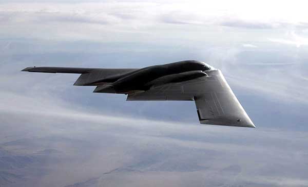
B-2 Spirit multi-role bomber capable of delivering both conventional and nuclear munitions. In December 2017, the Air Force completed a series of successful flight tests of M-code GPS using a Raytheon Company receiver on board a B-2 Spirit at Edwards Air Force Base, California. (Photo: U.S. Air Force/Bobby Garcia)
What advantages will M-code bring, over existing military GPS receivers?
GPS Directorate. Modernized GPS receiver cards under development with the Air Force MGUE Increment 1 program will enable the use of M-code and provide U.S. forces with enhanced position, navigation, and timing capabilities, in addition to improving resistance to threats, such as jamming efforts by adversaries.
How will keys and key distribution be managed?
GPS Directorate. None of this is publically releasable.
Will M-code be made available to other friendly nations? If so, how is this managed?
GPS Directorate. The current policy allows for the sale of M-code equipment to all 57 authorized GPS PPS nations. The M-code technology will be made available to these nations through the Foreign Military Sales process.
USER PERSPECTIVE
The Department of Defense supplied answers to the following questions for users and warfighters.
What are the benefits you perceive will come from new M-code GPS equipment?
DoD. Provides U.S. forces with enhanced position, navigation, and timing capabilities, in addition to improving resistance to threats, such as jamming efforts by adversaries.
Will it change how you perform military operations, or enable any new ones?
DoD. Modernized GPS receivers provide the next-generation GPS capabilities to the warfighter. Operational testing will enable the services to determine operational utility of MGUE. It will ensure our soldiers, sailors, airmen, and marines have the ability to get in, accomplish their mission, and get home accurately.
How will M-code-based GPS receivers be brought into operational service? Will there be a mass upgrade of assets, or a phased introduction?
DoD. Procurement of M-code-capable GPS receivers will be decided by the Services and executed by individual platforms and programs.
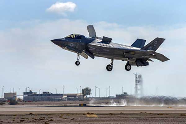
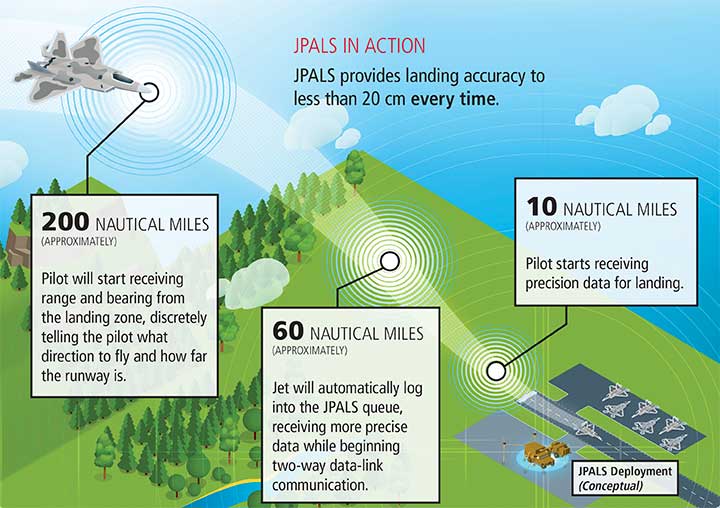
Earlier this year, Raytheon Company demonstrated a land-based expeditionary version of its Joint Precision Approach and Landing System (JPALS) for the first time to U.S. Air Force, Navy and Marine Corps officials at Marine Corps Air Station, Yuma, Arizona.
During the demonstration, F-35B pilots used the JPALS system on the jet to connect with the expeditionary system on the ground from 200 nautical miles away. From there, the system guided the pilot to a designated landing point on the runway.
“The need for precision landings in harsh environments isn’t limited to one military service and one airplane,” said Matt Gilligan, vice president at Raytheon’s Intelligence, Information and Services business. “JPALS can help any fixed or rotary-wing aircraft land in rugged, low-visibility environments at austere bases worldwide.”
The proof-of-concept event showed how the GPS-based system, which is currently used to guide F-35Bs onto ships in all weather, could be reconfigured into a mobile version to support landings in a traditional airport setting.
Infographic: Raytheon
Expeditionary JPALS supports the U.S. Air Force’s desire to use more austere, bare-base locations for future flying operations.
Currently in five transit cases, it could be repackaged for a variety of small transit vehicles transportable by C-130. Once on the ground, the system can be fully operational in under 90 minutes.
Spirent Federal Systems, a provider of GPS/GNSS test equipment, announced that Col. (retired) Bernard Gruber, former program director of what is now the U.S. Air Force GPS Directorate, has joined the company’s board of directors as government security committee chairman. Also joining as the chairman of the board is Robert Lollini.
Spirent Federal President/CEO Ellen Hall stated, “We are happy to have retired Col. Gruber and Bob Lollini joining our dynamic company. We are leading the industry in innovation and quality products for the U.S. government and these two new leaders will help us continue that momentum.”
Col. Bernie Gruber in 2012. (Photo: U.S. Air Force)
Bernard Gruber brings to the position the experience gained from a long and distinguished career in the government and military sector. Mr. Gruber has held several positions in important commands focused on navigation in space, including serving as the chief of Space and Global Integrated Intelligence at the Pentagon from 2009-2010, and director of the Global Positioning System (GPS) at the Los Angeles Air Force Base from 2010-2013. He is currently the director of Precision Guidance and Advanced Programs, Armament Systems at Northrop Grumman.
Robert Lollini is currently the chief executive officer and president of BioFire Defense LLC, a subsidiary and proxy company of bioMerieux. Lollini contributes to the board his broad understanding of strategic financial and executive management.
Spirent Federal Systems was formed in July 2001 by Spirent Communications as a wholly owned subsidiary and U.S. proxy company. Spirent Federal markets and sells Spirent Communications’ GNSS products in North America. The company also provides value-added features and ongoing customer support. Spirent Federal Systems is headquartered in Pleasant Grove, Utah, with support and sales offices throughout the U.S.
Acquisition Expands Orolia’s Global Footprint into Canada.
Orolia has acquired Skydel Solutions, a GPS/GNSS signal simulation company based in Montreal, Canada.
Orolia made the announcement at the Association of the U.S. Army’s Global Force Exhibition in Huntsville, Alabama.
Orolia is a resilient positioning, navigation and timing (PNT) solutions company and a partner of U.S., NATO and allied forces. The company provides end-to-end resilient PNT solutions, including scalable, modular and cost-effective technology to support PNT-reliant and critical defense and commercial applications.
Skydel’s capabilities allows Orolia to offer customers more diverse resilient PNT solutions with sophisticated testing and simulation protocols, additional customized signals, and superior vulnerability assessments for military and commercial applications where GNSS failure is not an option.
According to Orolia, as the latest addition to the Orolia portfolio, Skydel brand solutions bring a new paradigm to the GNSS simulator scene by combining innovative algorithms and off-the-shelf hardware to help protect the world’s most critical GNSS-reliant systems operating through GPS, Galileo and other GNSS.
Skydel technology also supports secure communications signals such as SAASM, M-code, PRS and other alternative signals with approved partners to provide real-world PNT vulnerability testing for critical infrastructure applications worldwide.
“The need for continuous, reliable GNSS signals is growing exponentially worldwide, particularly for military and commercial systems that depend on accurate PNT data,” said Orolia CEO Jean-Yves Courtois. “The threats to these systems are growing too, whether it’s through signal jamming, spoofing or meaconing. With Skydel’s unique industry expertise, Orolia now offers even more rigorous, broad spectrum testing and simulation solutions to ensure continuous signals, even in GNSS-denied environments.”
By combining graphics processing unit (GPU) accelerated computing and software-defined radios (SDR), Skydel-powered simulation solutions generate signals in real time, with uncompromising performance for demanding use cases. They are available as complete turnkey systems suitable for all GNSS simulation needs, including everything from compact test benches to complete CRPA test systems.
“Since our inception in 2014, Skydel has enjoyed exponential growth,” said Stéphane Hamel, CEO of Skydel. “This strategic move with Orolia will allow us to keep our focus on disruptive innovation and accelerate our global reach.”
Above: A montage of screenshots showing the various updates, from a February 2019 story about Skydel updating its SDX GNSS simulator to version 19.1 with Galileo Alt-BOC and more. (Image: Skydel)
DARPA has issued a Request for Information (RFI) to augment its understanding of state-of-the-art technologies for 3D mapping and surveying. (Photo: DARPA)
Request for Information pursues state-of-the-art technologies for collecting and characterizing 3D mapping and surveying data.
DARPA is seeking information on state-of-the-art technologies and methodologies for advanced mapping and surveying in support of the agency’s Subterranean (SubT) Challenge.
Georeferenced data — geographic coordinates tied to a map or image — could significantly improve the speed and accuracy of warfighters in time-sensitive active combat operations and disaster-related missions in the subterranean domain. Today, the majority of the underground environments are uncharted or inadequately mapped, including human-made tunnels, underground infrastructure, and natural cave networks.
Through the Request for Information, DARPA is looking for innovative technologies to collect highly accurate and reproducible ground-truth data for subterranean environments, which would potentially disrupt and positively leverage the subterranean domain without prohibitive cost and with less risk to human lives. These innovative technologies will allow for exploring and exploiting these dark and dirty environments that are too dangerous to deploy humans.
“What makes subterranean areas challenging for precision mapping and surveying — such as lack of GPS, constrained passages, dark or dust-filled air — is similar to what inhibits safe and speedy underground operations for our warfighters,” said Timothy Chung, program manager in DARPA’s Tactical Technology Office (TTO). “Building an accurate three-dimensional picture is a key enabler to rapidly and remotely exploring and searching subterranean spaces.”
DARPA is looking for commercial products, software, and services available to enable high-fidelity, 3D mapping and surveying of underground environments. Of interest are available technologies that offer high accuracy and high resolution, with the ability to provide precise and reproducible survey points without reliance on substantial infrastructure (such as access to global fixes underground).
Additionally, relevant software should also allow for generated data products to be easily manipulated, annotated, and rendered into 3D mesh objects for importing into simulation and game engine environments.
DARPA may select proposers to demonstrate their technologies or methods to determine feasibility of capabilities for potential use in the SubT Challenge in generating and sharing 3D datasets of underground environments.
Such accurately georeferenced data may aid in scoring the SubT competitors’ performance in identifying and reporting the location of artifacts placed within the course. In addition, renderings from these data may provide DARPA with additional visualization assets to showcase competition activities in real-time and post-production.
Few commercial UAV operations would be able to inspect transmissions lines, pipelines or train tracks without beyond visual line-of-sight (BVLOS) capability, but these key pieces of infrastructure often situate close to or transit across population centers. Further, many population centers have airports and low-level air traffic. Any tools to keep drones away from air traffic during BVLOS operations will significantly inspection companies. We review three promising solutions here.
Pipeline Inspection
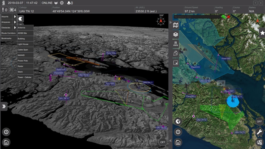
Kongsberg Geospatial in Ottawa, Canada has developed location visualization software tools that are used for air-traffic control, command and control, and air defense applications. The company has several decades of experience in these applications. Its IRIS software was used to support recent UAV oil pipeline inspection operations in Nigeria, providing safety critical airspace deconfliction, supervised by the Nigerian Civil Aviation Authority (NCAA).
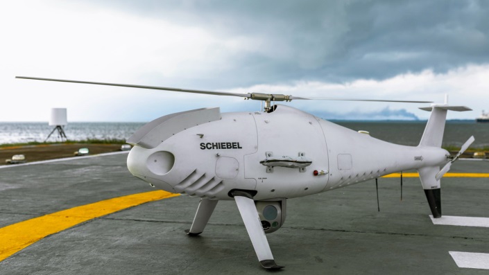
The pipeline project was undertaken by Aerial Robotix, a UAS services provider in Nigeria, who used adapted Kongsberg software in its control center to demonstrate safe BVLOS operations, and was then able to obtain the necessary permits. A Schiebel Camcopter S-100 UAV with a 200-kilometer BVLOS capability was used for flight inspection, operating both day and night, with real time high-definition payload imagery sent back to the control station.
Camcopter S-100 prior to BVLOS pipeline inspection flight in Nigeria. (Photo: Schiebel)
Nigeria has a major problem with gasoline theft from pipelines similar to those lines inspected during this project. Recently, 105 people perished in a blast from a ruptured pipe 30 miles north of the city of Umuahia, possibly during scavenging for leaking fuel. It has been claimed that the pipeline had been ruptured by saboteurs earlier, and for the following six weeks villagers had been collecting fuel. Pipeline vandalism is common in Nigeria, even given the risk of fire or explosion, or the risk of prosecution, or even the possibility of being shot on sight.
Unmanned Companion Fighter Aircraft
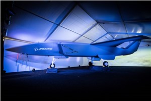
Boeing just unveiled a concept UAV which is apparently aimed at providing an airborne team-partner for manned aircraft.The concept was introduced at the Australian International Airshow by the Australian Minister for Defense, the Hon. Christopher Pyne MP. The project is slated for a significant R&D investment by the Australian Government and Boeing Australia.
Boeing Airpower Teaming System. (Photo: Boeing Company)Boeing Airpower Teaming System. (Photo: Boeing Company)
The concept model has fighter aircraft lines with a projected 2,000-mile range, autonomous capability, and significant intelligence, surveillance and reconnaissance sensor capability. Flying alongside manned fighter/attack aircraft with artificial intelligence simplifying control, the Airpower Teaming System is designed as a low-cost force multiplier.
The concept includes a pitch for international collaboration offering significant customization so countries can add local content, a key element for any aircraft program designed for off-shore sales.
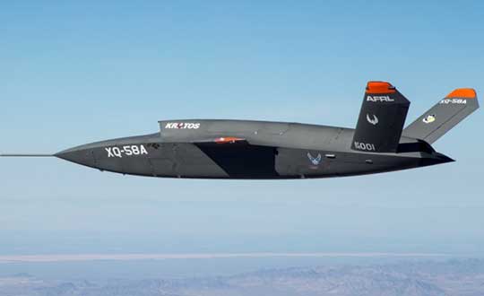
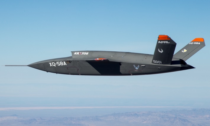
XQ-58A demonstrator in flight. (Photo: U.S. Air Force)
A day or so after the Airshow (maybe not wanting to be upstaged by Boeing’s announcement?) a release showed up about the first flight of the previously secret XQ-58A Valkyrie demonstrator. This is apparently a program by the US Air Force Research Laboratory (AFRL) partnered with Kratos Unmanned Aerial Systems to develop a UAS which looks to have very similar capabilities to that of the Boeing concept, perhaps at a significantly further advanced stage, with a much more mil-spec UAV sounding name.
The AFRL indicated that the XQ-58A is part of a Low Cost Attritable Aircraft Technology (LCAAT) (guess that means they don’t much mind losing a few) effort to come up with low-cost force multipliers which can be built quickly using commercial technology and operating from unprepared runways.
(From the Air Force: “The thought is to develop an inexpensive, configurable and producible on demand air vehicle. A number of military applications can be envisioned for an air vehicle with such a capability. One potential application is to use hundreds or thousands of such units in a campaign to overwhelm an enemy’s air defenses and “punch a hole” to enable higher value, less replaceable [aircraft] to engage or monitor enemy systems. Another potential application is to augment the capabilities of high-value intelligence, surveillance and reconnaissance, systems which may be limited in a specific campaign by distances, quantities, or threats. For all applications, the weapon system is expected to be an air vehicle that would return to base or to a separate location to be recovered. However, because of the mission and because of the low cost, the air vehicle would be attritable, meaning the Air Force would expect and could afford to lose many of the assets.”)
The current program took 2½ years to get to this flying prototype, which still seems pretty lengthy in terms of today’s commercial UAVs. The first flight from Yuma Proving Grounds in Arizona lasted an hour and a quarter and all went as expected. Five test flights are planned to check out functionality, aerodynamics, and launch and recovery systems. Kratos is perhaps better known for its family of target drones which have been in use by the US and internationally for some time.
Kratos BQM-177 Navy drone declared operational. (Photo: Naval Air Systems Command)
Kratos Defense & Security Solutions, Inc. announced in early March that its BQM-177A Subsonic Aerial Target (SSAT) has achieved Initial Operational Capability as reported by the US Navy. A Navy statement said “The first site the BQM-177A will be operated from is Pt Mugu, California. The target is capable of speeds in excess of 0.9 Mach and a sea-skimming altitude as low as 10 feet which provides sea-skimming anti-ship cruise missile threat emulation for the US Navy.”
Parachute System for DJI Phantom 4
Recent testing of the descent rate of a Phantom 4 equipped with a SafeAir parachute system indicated that this UAV/parachute combination may well meet the FAA’s recently published draft rules for flight over people. The parachute system uses on-board indicators to trigger parachute deployment. ParaZero (manufacturer of the SafeAir UAV parachute system) has developed standards, and promises to provide customers with certification data to support waiver applications for flight over people.
Wrap-up
So now we have intuitive software using terrain data and sensor inputs which can provide a visual overlay to supports BVLOS flights, concepts designs and prototypes to support the ‘Loyal Wingman’ approach – flying UAVs alongside existing defense aircraft as force multipliers – and advances towards UAV flight over people using certified parachute safety systems. Just a flavor of the flurry of recent new developments in the world of unmanned aircraft.