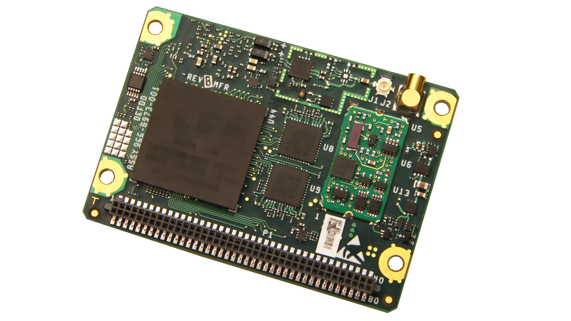
Collins Aerospace Systems, a unit of United Technologies Corp., has begun taking orders for its latest-generation Miniature PLGR Engine – M-Code (MPE-M) GPS receiver set for 2020 production deliveries.
According to independent testing, the MPE-M is the lowest size, weight and power (SWaP) small Type II form factor ground receiver available and incorporates the company’s recently certified Common GPS Module (CGM).
As a drop-in replacement for the thousands of customers using Collins’ Miniature PLGR Engine-SAASM (MPE-S) GPS receiver, the new MPE-M technology provides ten-times stronger anti-jamming capabilities for the direct acquisition of GPS signals than its predecessor.
The MPE-M is capable of receiving the current military Y-Code GPS signal along with the newer Military Code (M-Code) signal. For all GPS signals, the MPE-M provides warfighters improved security and assured positioning, and it satisfies the U.S. government’s requirement for all military GPS equipment to be M-code-capable.
“The MPE-M is ideal for lightweight, ground-based applications such as radios, blue force trackers, targeting devices, vehicle LRUs and small unmanned aircraft,” said Troy Brunk, vice president and general manager, Communication, Navigation and Electronic Warfare Systems for Collins Aerospace. “The implementation of M-code will provide our warfighters with increased mission effectiveness and safety due to the improved reliability of the signal.”
Collins Aerospace is currently the only military GPS receiver provider that manufactures its products in house, assuring control over quality and delivery schedules. The MPE-M’s security certification also makes the receiver eligible for export to U.S. allies through the Foreign Military Sales (FMS) program.
RNT Foundation Directors and Congressmen. From left: RADM Jeff Hathaway, USCG (ret); Rep. John Garamendi (D-CA); Rep. Peter DeFazio (D-OR); Dana A. Goward, SES, CAPT, USCG (ret); and CAPT Pauline Cook, USCG (ret). (Photo: Resilient PNT Foundation)
“It’s absolutely vital for national security that we get a terrestrial based, hard backup system [for GPS],” said Congressman Peter DeFazio (D-OR), chairman of the House Transportation and Infrastructure Committee.
His remarks came at an event organized by the RNT Foundation to recognize DeFazio and Congressman John Garamendi (D-CA) for their support of the National Timing Resilience and Security Act of 2018. Representative Garamendi is chairman of the House Armed Services Readiness subcommittee.
Garamendi first introduced legislation in 2016 to address the nation’s need for a GPS backup system. After going through several iterations, it was signed into law in December. The Act requires the Department of Transportation to establish a terrestrial timing system by 2020. Also, that the new system be expandable to one that can be used for location and navigation.
Congress funded a GPS Backup Technology Demonstration through a Department of Defense appropriation in early 2018. The demonstration was intended to be a joint project of the Departments of Defense, Homeland Security and Transportation. A delay in transferring funds from Defense to the other two departments put the demonstration almost a year behind schedule. Now that the project is underway, Transportation Department representatives have said they want to transition directly from the demonstration to deciding upon and implementing the mandated timing system.
At the event, DeFazio remarked that as a boater and hiker he is an avid user of GPS. He mentioned that it is an “ incredible utility, but I also know of its vulnerability. It’s critical to national security and the meaningful movement of everything in the United States of America from airplanes to surface transportation and others … It’s absolutely vital for national security that we get a terrestrial based, hard backup system.” He also noted that Congressman Garamendi has been the driving force for this issue in the House of Representatives.
Speaking about his current role on the Armed Services committee, Garamendi said “The reality is that the military is not prepared for the loss of the GPS signal, and they are just now becoming aware after seven years of beating them over the head saying ‘guys, what are you going to do when you don’t have GPS?’” Garamendi noted that the military would be a big users of the domestic backup system.
He also regretted that after “… years of people saying ‘single point of failure’ for the American economy and system is the loss of GPS” the nation is not farther along to having a backup system.
The RNT Foundation presented the congressmen with plaques showing images of a GPS satellite and a terrestrial transmission tower, and 0ne of America’s “first GPS devices” — a 102-year-old copy of The American Practical Navigator by Nathaniel Bowditch.
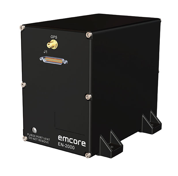
Emcore Corporation has launched the EN-2000 to the Emcore-Orion series of micro-inertial navigation (MINAV) systems.
The new EN-2000 will represent the pinnacle of performance in Emcore navigation systems, and realizes the company’s vision of a closed-loop, solid-state design that will deliver higher performance at lower cost than traditional RLG (ring laser gyroscope) navigation systems.
The EN-2000 expands Emcore’s navigation systems line that also includes the EN-1000 introduced in 2017. The Emcore-Orion series of inertial navigation system (INS) are designed for use in a broad range of defense, aviation and aeronautics applications.
The unit was introduced at the Paris Air Show, held June 17-20 at the Parc des Expositions Paris-le Bourget in Hall 6, Stand #C65.
Today, there is an ever-increasing premium being placed on modern navigation systems for improved size, weight and power (SWaP). Traditional RLG navigation systems placed a premium on accuracy and performance, but not SWaP. Typical RLG and FOG systems are large and heavy, ranging in volume from 330 in3 to 540 in3, weighing 13 to 22 pounds with power requirements of 25 to 38 watts.
Many modern weapon systems are now remotely operated, unmanned or man-portable and may need to operate where GPS is unavailable or denied. The compact EN-2000 is designed for these applications. It puts a premium on accuracy and performance, but also on smaller size, less weight and lower power consumption.
The new Emcore-Orion EN-2000 MINAV is a three-axis design using the company’s proprietary, next-generation solid-state optical transceiver with advanced integrated optics, combined with all new field programmable gate array (FPGA) electronics to deliver stand-alone aircraft-grade navigator performance at one-third the SWaP of legacy or competing systems.
The EN-2000 model comes in two standard versions, an IMU version and a standalone INS configuration. The INS version can gyrocompass to less than 0.7 milliradians and maintain near-GPS-level positional accuracy without the use of a GPS receiver. This makes it suitable for use in GPS-denied environments.
To provide customers with additional flexibility, the unit is also capable of being aided by an external GPS for applications where needed.
The Emcore-Orion EN-2000 is compact and lightweight, weighing less than 7 pounds, with very low power consumption of 10 watts. It can deliver twice the performance of the EN-1000 with the same form factor.
The low SWaP of the EN-2000 makes it a suitable inertial navigation system for unmanned aerial vehicles (UAVs), unmanned underwater vehicles (UUVs), unmanned ground vehicles (UGVs), manned aircraft, rotorcraft and dismounted soldier applications.
“With the introduction of the EN-2000, Emcore can now offer class-leading performance at a fraction of the size, weight and power of competing systems with increased reliability,” said David Faulkner, Emcore vice president and general manager of aerospace and defense. “Emcore’s goal of a true full navigation system that can replace older technology navigation systems in UAVs, UUVs, UGVs, manned aircraft and rotorcraft is fully realized with the introduction of the EN-2000.”
“Our Emcore-Orion series micro navigators improve dramatically on the size and cost of navigation and azimuth sensing equipment by utilizing affordable lightweight sensors that reduce overall system weight and increase accuracy,” added K.K. Wong, Sr., director of fiber optic gyro products for Emcore. “The digital interface is also fully programmable at Emcore’s factory enabling it to directly replace competing units.”
Emcore Corporation, a provider of advanced mixed-signal optics products that provide the foundation for defense systems, has acquired Systron Donner Inertial, Inc. (SDI) from Resilience Capital Partners for approximately $25.8 million. Consideration will be in the form of $22.8 million in cash plus 810,698 shares of Emcore common stock.
Highlights of the transaction are as follows:
Expected to increase the navigation systems products to over one third of Emcore’s total revenue; making the aerospace and defense market Emcore’s largest revenue source.
Expands Emcore’s navigation systems product portfolio and accelerates growth through the contribution of substantial additional revenue, which in the unaudited books and records of SDI, totaled approximately $28 million for the 12 months ended March 31, 2019.
Adds additional Raytheon, Lockheed Martin and Boeing 777X programs to Emcore’s existing navigation systems portfolio.
Expected to create material operating synergies in manufacturing, sales and engineering.
Expected to be non-GAAP EPS accretive by the end of calendar 2019
Emcore intends to add SDI’s business to its current navigation product line and support these products from facilities in Concord, California. Through the transaction, Emcore has acquired all of the outstanding assets and liabilities of SDI, including SDI’s 100,000 square foot production facility in Concord.
“This acquisition delivers immediate scale to our growing navigation systems product line and positions Emcore as one of the largest independent inertial navigation providers in the industry,” said Jeff Rittichier, president and CEO of Emcore. “Merging Emcore’s existing navigation systems product line with SDI’s strong brand, technology and backlog, and program wins, instantly creates a stable, growing, and technically advanced business well-positioned to disrupt market norms.
“SDI provides Emcore with a scalable, chip-based platform for higher volume gyro applications, while delivering superior performance compared to its competitors. Combining this business into Emcore will allow us to provide customers with a full product suite that serves a broad range of requirements across both the tactical and navigation grade segments of the market,” concluded Rittichier.
Emcore also announced the appointment of Bruce Grooms to its board of directors. Grooms has extensive senior management and executive experience in both the private sector and the U.S. Navy. From 2015 until June 1, 2019, Grooms served as Raytheon’s vice president of U.S. Business Development, Navy and Marine Corps Programs, where he was responsible for identifying and pursuing U.S. Navy and Marine Corps business growth opportunities for Raytheon and was one of its primary contacts with Navy customers, pursuing opportunities in the evolving cyber area, undersea growth and next-generation strike weapons.
Safran and Orolia are partnering to offer the latest resilient positioning, navigation and timing (PNT) solutions for military forces, especially in GNSS-denied environments.
This partnership will provide mission-critical equipment for air, land, sea and space programs in environments where GNSS signals are not available or degraded. Whether the outage is unintentional or intentional (jamming, meaconing or spoofing), the Safran-Orolia partnership will provide an alternative to GNSS-dependent military systems.
The Safran-Orolia team will offer military forces an unparalleled convergence of PNT capabilities, including Orolia’s portfolio of precise timing references and PNT sensor-fusion technology, as well as Safran’s proven defense inertial navigation solutions. Initial program priorities include navigation warfare (NAVWAR), along with mobile and fixed PNT solutions.
“Today’s military operations are increasingly mobile and global, with mission priorities that often bring them into territories where GNSS jamming and spoofing are becoming common threats,” said Orolia CEO Jean-Yves Courtois. “We’re proud to introduce this unique resilient PNT military partnership to better protect and enable mobile operations for NATO and allied countries worldwide.”
“In a world full of uncertainty, our partnership will provide autonomous and sovereign PNT solutions to Armed Forces facing harsh GNSS denied environments,” said Safran Electronics & Defense Chief Executive Officer Martin Sion.
Orolia’s PNT solutions improve the reliability, performance and safety of critical, remote or high-risk operations. With locations in more than 100 countries, Orolia provides virtually failsafe GNSS and PNT solutions to support military and commercial applications worldwide.
Safran is an international high-technology group, operating in the aircraft propulsion and equipment, space and defense markets. Safran has a global presence, with more than 92,000 employees and sales of 21 billion euros in 2018.
The transaction will create a systems provider with advanced technologies to address rapidly growing segments within aerospace and defense, the companies said. Raytheon is a defense contractor, while United Technologies is an aerospace company comprised of Collins Aerospace and Pratt & Whitney.
The combined company, Raytheon Technologies Corporation, will offer a complementary portfolio of platform-agnostic aerospace and defense technologies, expanded technology and R&D capabilities to deliver innovative and cost-effective solutions aligned with customer priorities and the national defense strategies of the U.S. and its allies and friends.
The merger is expected to close in the first half of 2020, following completion by United Technologies of the previously announced separation of its Otis and Carrier businesses, which are not part of the merger. The timing of the separation of Otis and Carrier is not expected to be affected by the proposed merger and remains on track for completion in the first half of 2020. The merger is intended to qualify as a tax-free reorganization for U.S. federal income tax purposes.
The combined company will have approximately $74 billion in pro forma 2019 sales.
Under the terms of the agreement, which was unanimously approved by the boards of directors of both companies, Raytheon shareowners will receive 2.3348 shares in the combined company for each Raytheon share. Upon completion of the merger, United Technologies shareowners will own approximately 57 percent and Raytheon shareowners will own approximately 43 percent of the combined company on a fully diluted basis.
“Today is an exciting and transformational day for our companies, and one that brings with it tremendous opportunity for our future success. Raytheon Technologies will continue a legacy of innovation with an expanded aerospace and defense portfolio supported by the world’s most dedicated workforce,” said Tom Kennedy, Raytheon chairman and CEO. “With our enhanced capabilities, we will deliver value to our customers by anticipating and addressing their most complex challenges, while delivering significant value to shareowners.”
“The combination of United Technologies and Raytheon will define the future of aerospace and defense,” said Greg Hayes, United Technologies chairman and CEO. “Our two companies have iconic brands that share a long history of innovation, customer focus and proven execution. By joining forces, we will have unsurpassed technology and expanded R&D capabilities that will allow us to invest through business cycles and address our customers’ highest priorities. Merging our portfolios will also deliver cost and revenue synergies that will create long-term value for our customers and shareowners.”
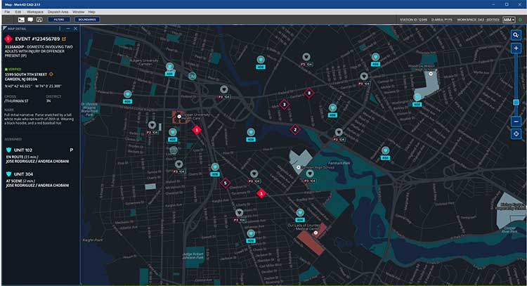
Polaris Wireless is partnering with Mark43 to integrate 3D location technology into computer-aided dispatch systems for public safety organizations. Polaris Wireless is a provider of software-based wireless location solution.
The joint solution will enable police and fire departments to track personnel and assets with pinpoint location, including indoors and in high-rise buildings, with floor-level accuracy. It delivers enhanced situational awareness and improved operational efficiency, which helps save lives and additional costs.
Mark43 Computer Aided Dispatch and Automatic Vehicle Location. (Screenshot: Mark43)
Mark43 is a cloud-based public safety software provider. Its Mark43 CAD software provides mobile field units with precise information on laptops or tablets inside a vehicle. Built on AWS GovCloud, Mark43 works with police and fire departments to make sure web-connected units stay mobile in the cloud.
With the addition of 3D location, command and control centers can direct firefighters to the correct floor in a structural fire or ensure SWAT teams enter at the correct floor of a high-rise building. In more routine situations, such as tracking officers or equipment in a large municipal headquarters, 3D location helps increase efficiency and allocate resources more wisely.
Mark43 is purpose-built in the cloud to support interoperability with third-party systems and devices. This enables the Mark43 CAD to seamlessly integrate with the Polaris Wireless 3D Location Platform, which is cloud-based and available to application developers via a standard Android and iOS Software Development Kit (SDK).
The platform relies on Polaris Wireless’ 3D location technology, which is able to locate devices on the vertical axis within 3 meters, floor level, utilizing all available signals and sensor measurements combined with the company’s patented algorithms.
Screenshot: Mark43
By operating independently, or “over the top,” of wireless carrier networks, the platform is universal, enabling applications to locate any device on any network — an important consideration when police and fire departments operate devices across several networks.
“Giving command and control centers full visibility into first responders’ locations is crucial when it comes to emergency dispatch, where every second counts,” said Scott Crouch, Mark43 co-founder and CEO. “We are always aiming to integrate the best possible capabilities into our suite of offerings, and we look forward to working with Polaris Wireless to increase safety and efficiency for our first responders.”
“Our 3D location is enabling new use cases in public safety applications with our partnership and integration into Mark43 CAD systems,” said Amir Sattar, senior vice president of operations for Polaris Wireless. “Dispatching police and firefighters to the precise location, including the correct floor number, represents a major advancement for public safety and a significant benefit for the communities they serve.”
Polaris Wireless and Mark43 are exploring opportunities to trial the application with public safety organizations.
Attendees at the NENA 2019 Event (June 14-19) in Orlando, Florida, can visit Mark43’s booth #321 to learn more.
Dean Kemp, defense segment manager for NovAtel, has joined the speakers’ panel for the June 27 complimentary webinar, Advanced Simulation Test Systems for Controlled Reception Pattern Antennas. He will present unique content alongside Lisa Perdue, simulation product manager for Orolia, and Stéphane Hamel, director of testing at Orolia.
Kemp has over 20 years of academic, industrial and business experience in engineering products and services. He spent a significant part of his career involved in antenna design and development, including controlled reception pattern antennas (CRPAs) for GPS anti-jam systems. As Defense Segment Manager, he is committed to precise, assured positioning and timing to address the needs of Navigation Warfare (NAVWAR) professionals and is dedicated to delivering high-quality products into the defense markets.
He holds a Ph.D. in antennas, radiowave propagation and computational electromagnetics from the University of Liverpool and an MBA from the University of Warwick. Prior to joining NovAtel, he worked at API Technologies, Cobham and Cobham Technical Services. His key technical skills include antenna/RF/microwave engineering, software development (Matlab, Fortran, VBA, Python), data analysis and processing, and test and measurement.
CRPAs are advanced, multi-element antenna solutions designed to protect a GNSS/GPS receiver from jamming sources. When combined with antenna electronics, they form an anti-jam antenna system (AJAS). These systems utilize several available technologies and vary in the number of elements.
This webinar will cover the basics of AJAS and CRPA, and the methods used to test them. Details on simulation system configurations, calibration techniques, and use case examples will also be presented. The webinar is sponsored by Orolia, a global provider of GPS/GNSS and resilient PNT solutions to support military and commercial applications.
The U.S. Army will send prototype anti-jamming systems to its 2nd Cavalry Regiment, stationed in Europe, in September to aid forces under GPS jamming or spoofing conditions. The first generation of Mounted Assured PNT Systems (MAPS) and anti-jam antennas are nearly ready for integration aboard armored Stryker vehicles, and the Army is already evaluating proposals for an upgraded version incorporating an inertial navigation system (INS) for further resilience.
The shipment comes in response to widespread Russian jamming of GPS signals from the sub-Arctic to the Middle East, and in tacit, likely tardy acknowledgment of Russian superiority in electronic warfare.
An Interim Armored Vehicle “Stryker” and AH-64 Apache helicopters with Battle Group Poland move to secure an area during a lethality demonstration as part of Saber Strike 18 in June 2018. (Photo: U.S. Army/Spc. Hubert D. Delany III, 22nd Mobile Public Affairs Detachment)
Col. Nickolas Kioutas, Army project manager for positioning, navigation and timing (PNT), announced the move at the annual C4ISRnet conference in Arlington, Virginia. C4ISR stands for Command, Control, Communications, Computer, Intelligence, Surveillance, and Reconnaissance, or more broadly, electronic and other systems, procedures and techniques used to collect and disseminate information.
Three vendors are providing prototypes for the IMU-equipped second-generation MAPS, or MAPS-2, with testing to begin in September. A MAPS-3 capability, drawing on lessons learned in 1 and 2, may get underway soon. GPS Source, now a subsidiary of General Dynamics Mission Systems, made MAPS-1 and is now competing for MAPS-2.
The initiative reflects a new approach by the Army of “doing much smaller, iterative programs,” according to Col Kioutas. Traditionally, U.S. armed forces have taken years (and sometimes more years) to develop large, complex weaponry and supporting systems, and then even longer to deploy them. By the time they arrive in the operational theater, they are obsolete.
Rapid deployment of smaller, quickly designed and manufactured batches creates the opportunity for rapid feedback on what works and what doesn’t, with equally rapid return to the design board and re-manufacture. In other words, “shoot, aim, ready.”
Kioutas and crew are also flouting another U.S. military tenet, that in which previously “[we] asked for exactly what we wanted and industry built exactly to that. We don’t know exactly what we want. Tell us how we should do this the best, and then we’ll test that.” The PNT program has left requirements broad and open to change, knowing how quickly technology develops — and is shown to be vulnerable.
The Stryker is an eight-wheeled armored fighting vehicle, basically a lightly armored tank or heavily-armored troop carrier that is more road-friendly, that is, faster, than a tank. It has several variants of armament, armor and troop-carrying capacity. It saw extensive use in the Iraq counter-insurgency campaign.
DroneGun, part of the DroneShield anti-UAV system. (Photo: DroneShield)
DroneShield Ltd. and Collins Aerospace Systems, a unit of United Technologies, have entered a Memorandum of Understanding (MOU) to collaborate on opportunities with the Australian military, as well as globally.
The intent is to add DroneShield’s counter-drone capabilities to Collins’ surveillance systems that its customers are already using.
Collins Aerospace is a supplier of aerospace and defense products. In Australia, it holds current contracts within the Australian Defence Force.
DroneShield is a public Australian company whose products include a suite of counter-drone technologies capable of protecting bases and forward-deployed groups against enemy drone threats.
DroneShield’s products include DroneSentinel (a sensor fusion, multi-method drone detection system), DroneSentry (a combined detection and interdiction system), DroneGun Tactical (a handheld rifle-shaped drone-mitigation device) and RfPatrol (a body-worn drone detection device).
DroneShield Chief Executive Officer Oleg Vornik commented, “Collins Aerospace has a leading position in the Australian defence market and we’re pleased to work together on opportunities that complement our capabilities to enhance customer value.”
Updated Software. DroneShield has begun the rollout of firmware version 1.1 of its DroneShieldComplete software for its DroneSentinel and DroneSentry counter-drone systems.
Enhancements include a number of features, such as pinpointing locations of pilots of detected drones. This allows for additional counterdrone procedures by customers, such as apprehending the pilots instead of neutralizing the drones directly.
This is expected to be of a substantial benefit for customers who are not legally able to deploy drone countermeasures, as well as enabling them to deal with the cause of the drone-related issues.
DroneShieldComplete 1.1 firmware, showing pilot detection capability with flags. (Photo: DroneShield Ltd.)
“The addition of the capability to locate and apprehend drone pilots without the need for taking down the drone has been developed in response to significant customer demand, and we expect this feature to be utilised by a number of our customers,” Vernik said.
Protection from jamming has emerged as the key concern of of both national and organizational/corporate infrastructures. The world abounds in bad actors, and systems based on GNSS signals are uniquely vulnerable. A basic component of any anti-jamming (AJ) strategy is a shielded antenna. An upcoming webinar, June 27, gives a primer and several advanced looks at developing such an antenna-based AJ campaign. Register here for the complimentary webinar.
Anti-jam antennas use techniques, such as nulling or beam-forming, to mitigate the effects of interfering signals. (Image: Orolia)
Controlled reception-pattern antennas (CRPAs) are advanced, multi-element antenna solutions that protect a GNSS/GPS receiver from jamming sources. When combined with antenna electronics, they form an anti-jam antenna system (AJAS). These systems utilize several available technologies and vary in the number of elements.
CRPAs will play an increasing role in the GPS/GNSS landscape. Initially developed in the military domain, they are now entering the civilian market and are poised to bring their benefits to the fields of aerospace, ground transportation, autonomous driving and others. Engineers working with GNSS systems that employ CRPAs and multi-element antennas need special test systems since they need to replicate very specific test conditions that are impossible with live signals.
These complex antenna systems require advanced GNSS simulation equipment in order to be designed and validated, as well as to test their performance. These test systems come in two forms — an anechoic chamber system used to test the CRPA antenna over the air, and a wavefront simulator used to test the antenna electronics with a direct cable connection.
Webinar speakers:
Perdue
Lisa Perdue, Product Manager, Orolia. Perdue is an expert in testing critical GPS and GNSS systems. She has trained hundreds of engineers and technicians who are responsible for high-reliability positioning, navigation and timing applications. She took a lead role in the development of the first GNSS Vulnerability Test System and speaks widely on the topic at many industry conferences.
Hamel
Stéphane Hamel, Director, Testing, Orolia. With a career spanning more than 20 years in engineering test and RF, Hamel has developed many innovative and large-scale products to test semiconductor devices, radios and GNSS receivers. In 2014, he founded Skydel, now part of Orolia. Hamel is one of the architects behind the Skydel SDX GNSS simulator.
Abom, a company that designs sophisticated commercial goggles, has launched new augmented reality (AR) goggles.
Designed for safety, industrial and military markets, Abom’s P3 augmented reality goggles feature accurate tracking of orientation, velocity and positioning using IMU/GPS-GNSS/INS receiver capability.
Other features include 3D spatial mapping and tracking, integrated VX Inc. CNED display technology, and an array of integrated image sensors and advanced embedded electronics. The goggles’ stereoscopic dual displays have an ultra-high-brightness output with adjustable control and 1080p output.
The goggles are optimized with a military-ballistics-rated lens (MIL-PRF 32432A) that complies with the Military Compliance Eye Protection (MCEP) program, meeting many challenging elements of the U.S. Army’s IVAS specification (HUD 3.0).
For industrial applications, the P3 also meets ANSI Z87.1+ high-mass impact rating and IP-55 ingress protection against water and dust, which opens the door for supporting National Safety Council technology initiatives and requirements for meeting extreme IP-67 rating compliance.
The P3 goggles are field-use ready and designed for extreme environmental durability and cold-weather climate conditions where demanding ruggedized performance is critical. It has advanced thermal image sensors, and embedded within the Goggle Chassis is an ultra-high-performance depth camera supported by two infrared cameras optimized for low-light conditions up to 10 meters.
The goggles incorporate Abom’s patented ultra-low power thin-film technology, making it impossible for fog to survive on the inner surface of the eyewear, according to the company.
“Abom’s award-winning heated goggle technology, now military approved, has made integration and optimization with immersive, augmented reality display technology the perfect solution for highly ruggedized extreme use-cases that exceed industry standards for both quality and performance,” said Jack Cornelius, Abom CEO.
“Abom’s development partner for the P3 Goggle, VX Inc., has pushed the limits of mechanical and electrical engineering design performance,” Cornelius said.