The VIA-100G GPS/IMU by Karel Electronics. Photo: Karel Electronics
The VIA-100G, an integrated GPS and MEMS-IMU (inertial measurement system), has been added to the ViaNav inertial navigation system family produced by Karel Electronics Corporation.
Featuring a high-accuracy fusion filter running on an embedded processor, the VIA-100G provides all the functions of a vertical reference unit (VRU), an attitude and heading reference system (AHRS) and integrated GPS/IMU system. The system contains GPS, 3D gyroscopes, 3D accelerometers, a magnetometer, a static pressure sensor and temperature sensors in a compact and rugged enclosure. The embedded processor provides driftless and real-time navigation information over a wide range of temperature in dynamic and static conditions, Karel said.
The sensors are integrated with a highly accurate fusion filter. A Kalman filter running on an embedded processor fuses data from the IMU, GPS, magnetometer, altimeter and barometer in an optimal manner to output highly accurate navigation solutions. VIA-100G outputs high-frequency position, velocity and attitude information in addition to calibrated 3D acceleration, rotation, magnetometer and pressure data.
The ViaNav product family includes other navigation products designed to be used in stability, guidance, control and navigation applications in industry. The VIA-100 line includes:
VIA-100I, is an inertial measurement unit with 3D accelerometers and 3D gyroscopes.
VIA-100A, is a 3 DOF AHRS that provides driftless real-time orientation information over the full 360 degrees of angular motion on all three axes. It includes 3D accelerometers, 3D gyroscopes and 3D magnetometers.
VIA-100A+, is a 3 DOF AHRS that provides driftless real-time orientation information. It includes a multi-IMU configuration and employs an optimum filter to lower IMU noise level. It provides 3D orientation with improved accuracy and reliability.
The ION Joint Navigation Conference, sponsored by the ION’s Military Division, is the largest U.S. military positioning, navigation and timing (PNT) conference of the year with joint service and government participation, ION said. The event will focus on technical advances in guidance, navigation and control (GN&C), with emphasis on joint development, test and support of affordable GN&C systems, logistics and integration.
From an operational perspective, the conference will also focus on advances in battlefield applications of GPS; critical strengths and weaknesses of fielded navigation devices; warfighter PNT requirements and solutions; and navigation warfare.
For Official Use Only (FOUO), United States only, sessions will be held June 22-24 at the Renaissance Orlando at SeaWorld, Orlando. The U.S. only classified sessions will be held June 25 at Shades of Green Walt Disney World.
The ION JNC features more than 200 operational presentations on a diverse array of topics. Abstracts are being accepted through March 4.
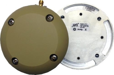
GPS Source has released a new GNSS antenna that is robust, lightweight, and suitable for harsh environments. It is designed for long-term, high-precision applications worldwide, the company said.
The antenna was engineered for the demanding aviation environment, in both commercial and military applications. Built to military standards (MIL-STD), it is impact resistant, tolerant of exposure to dust, chemicals and jet fuels, and has the ability to withstand shock and vibration.
Signal reception is unaffected by antenna placement. Designed to operate in the most extreme and demanding applications, it gives outstanding results, enabling maximum satellite reception, with ultra-low Dilution of Precision (DOP), GPS Source said.
“We are very excited about the new GNSS antenna,” said Robert Horton, CEO of GPS Source. “Our advanced technology provides superior performance in both GPS L1/L2 and GLONASS L1/L2. This is the best solution for technically demanding users.”
The antenna is available in multiple colors and with multiple connector options.
The long-anticipated 2016 President’s Budget (PB) was submitted to Congress in early February. The PB is the spark that ignites the lengthy and often contentious congressional budget process, including: adopting a budget resolution framework, developing numerous discretionary spending bills, reconciling legislation between the House and Senate, approving continuing resolution stop-gap measures and finally, hopefully, appropriating funds for various programs — including the Global Positioning System (GPS) as part of the Department of Defense’s (DoD’s) U.S. Air Force (USAF) budget request.
For FY (Fiscal Year 1 Oct – 30 Sep) 2016, the U.S. Air Force requested a topline budget of $122.2 billion in Air Force controlled funding that exceeds funding levels recommended by the OMB (Office of Management and Budget) and laid out in the Budget Control Act by almost $10 billion. Several well-meaning friends still in high places in the government immediately sent me copies of the USAF budget while it was still warm, so to speak, and thought that I would be “properly incensed” — proffered one old friend — over the so-called $10B overdraft. I hate to disappoint my friends, but in the spirit of the USAF policy of putting the Bottom Line Up Front, I applaud the Air Force action and personally think it may be too little, too late. The supplemental request or overdraft should probably have been more on the order of $20B, not $10B.
Hollow Force
This is not an emotional reaction, but a reasoned statement by a seasoned veteran airman of 30 years in the USAF, yours truly, who served through at least two periods of a “hollow force” that were devastating not only to the USAF as an institution, but to the DoD as a whole and to all the personnel who served during these austere and dangerous times. And, yes, I am equating a hollow force with a dangerous force. Indeed, the term “hollow force” officially refers to military and government forces that certainly, on the surface, appear to be “mission ready,” but upon close examination suffer from moderate to severe shortages of personnel and equipment as well as deficiencies, to varying degrees, in training.
Gen Mark A Welsh III, Chief of Staff, USAF, testifying before the Senate Armed Services Committee 201 (Photo courtesy of USAF – SSG Sean K. Harp).
In recent testimony before the Senate Armed Services Committee, along with his fellow service chiefs, General Mark A. Welsh III, chief of staff of the United States Air Force, laid out the dangers inherent in the hollow force when he stated:
“Last year, our readiness levels reached an all-time low. As we struggle to recover, we don’t have enough units ready to respond immediately to a major contingency, and we’re not always able to provide fully mission-ready units to meet our combatant commanders’ routine rotational requirements.
“The Air Force’s modernization forecasts also are bleak. About 20 percent of [our] aircraft flying today were built in the 1950s and 1960s, and more than half of the rest are 25 years old or older.
“And now, due to sequestration, we’ve cut about 50 percent of our currently planned modernization programs.”
To someone who lived through the hollow force in the past, this is a scary description and prospect for our airmen. In describing the results of budget cuts and difficult decisions regarding program terminations that result in a hollow force, General Welsh put it this way:
“Without these tough calls, the Air Force ‘will be neither ready to fight today, nor viable against the threats of tomorrow’.”
Indeed, a hollow force puts every ones lives in danger. During the post-Vietnam hollow force created by the peanut farmer, there were times when there were B52 aircraft sitting alert just for the spy satellite photo ops that did not have engines in the nacelles nor certified crews to fly them. Aircrews were lucky if they were able to fly four hours per month, and believe me, that made us all less than proficient. I remember one incident specifically. My oxygen (O2) mask had failed on a previous flight and I needed a new one. In the high-performance aircraft in which we flew, regulations required an O2 mask be attached to our helmet and actually in place with crewmembers in the cockpit breathing pure (100%) O2 above a certain altitude. Because of budget cuts, I was issued a waiver, a piece of paper that said I was legal to fly without a fully functioning O2 mask. Fortunately I never was forced to fly without a fully functioning O2 mask, but what if I had been? What if I had passed out from O2 deprivation? What about the other members of the crew? What purpose did the piece of paper serve, other than mollifying a paper pusher’s conscience? Would the Air Force crash investigators have found it in the wreckage and said, “Oh, it’s OK, he had a waiver!” These are the types of things that can happen with a “hollow force.” We don’t need to go there again, and if nothing else, the extra $10B may be just the ticket to keep the aircrews proficient and equipment maintained.
The Color of Money
I know that budgeting and spending other people’s money seems like a simple issue, but with the government, nothing is ever simple. Consequently, the DoD has established an entire university system, known as the Defense Acquisition University (DAU), to train acquisition, program and financial officials in handling government acquisition funds, along with other procurement activities. Under the Budget Control Act guidelines and the Congressional cost-cutting exercise known as Seques-castration, 2016 is another cost-cutting year. That is significant when you understand that the USAF and all of DoD are still reeling from more than ten years of war, on more than one front, along with previously mandated significant budget and manpower cuts that seriously impacted the ability of the USAF to accomplish its multitude of missions.
Consider that budget cuts have a lingering, insidious and costly effect in equipment not maintained or replaced, training not accomplished, R&D not conducted, new technologies not developed, and inevitably the inability to accomplish the mission. A lot of the complexity in these budget-cutting moves relates to what the government refers to as the color of money. For example budgetary funds are appropriated and obligated for the USAF, and most other services, according to the following formula:
O&M – Operations and Maintenance – Obligated for 1 year
MILPERS – Military Personnel – Obligated for 1 year
RDT&E – Res Dev Test & Eval – Obligated for 2 years
PROC – Procurement – Obligated for 3 years
MILCON – Military Construction – Obligated for 5 years
As you can see, all funds are not obligated for just one year and then the money expires. Indeed, there are several colors of money, and failing to fund an RDT&E effort can have catastrophic results on the future of that program and associated programs that might benefit from the technology not developed. At any one time, the USAF is juggling budgets stretching across years and programs and moving money or robbing Peter to pay Paul.
FM (Financial Management) or financial and program management gurus at any one time are managing funds that originated as many as five years previously, plus the current year’s budget, while planning on how to use funds that might carry over to next year. They have just submitted the FY16 budget, which also means they are now hard at work on the FY17 budget without knowing what will be obligated for FY16. Across all those budget years, they have to deal with the arcane rules concerning the color of money. Yes, they are professionals (I’ve been married to one of the best for 35+ years), and they do a great job, but face it — sometimes they are just taking a well-educated guess and hoping for supplemental funding just to meet basic requirements.
Seriously, FM’ers live for the fairytale that one day a combatant commander will say, “Hey, your mission is more important than mine, so I will ‘MIPR’ (a one-time financial move) my funding to your budget line for your project.” Let’s see — a pig is not aerodynamically designed to fly…
Space
Funding for all space programs is especially critical, as the entire space arena is known as a force multiplier, in that satellites and space platforms provide and enable capabilities that increase the effectiveness and reach of all military and government personnel. Therefore, when space programs are not funded, delayed or are cut, the impact ripples across the entire DOD. This is especially true of GPS and PNT (Position, Navigation and Timing) systems which have become so ubiquitous, they are considered a must-have utility for billions of users around the globe, not just the U.S. government. In fact, military and government users may be the smallest segment of users for GPS and PNT services today, which is ironic when you consider that, as General John Hyten (USAF), commander of Air Force Space Command, loves to remind us, “GPS is provided to the world, and over three billion plus users, free of charge 24/7, by the United States Air Force.”
OCX – Next-Generation Space Control Segment
Unfortunately, a couple of major GPS-related programs are in trouble. For OCX, the Next-Generation Control Segment for GPS, my sources tell me, and 2016 budget documents clearly show, that current costs attributable to the prime contractor greatly exceed the contract award specification of ~$886M by a factor of 100% ,with a delivery date still far out on the horizon — somewhere around 2020 with a total program costs of $3.6B. That’s the bad news; the good news is there are definitely sound alternatives, and my sources tell me they are being belatedly explored.
Sometimes the behemoth primes are just that: too big and too expensive. Oftentimes the real subject matter experts (SMEs) reside in the smaller, boutique, more agile companies that can do the job in 24 months for $200M, which is a price that was quoted to me recently by a company with skin in the game, since their software products are responsible for launching and controlling all of the GPS satellites launched in the last eight years without a single failure. Plus, sources inside the company tell me that they have already developed a complete launch and initial checkout system for GPS III, which the OCX prime contractor is still struggling to construct.
This is where the USAF and OSD must step back and assess the OCX program for all its merits versus costs. GPS is not that complicated a satellite system, and yet we are on course to spend $3.6B for a ground C2 (Command and Control) system that will still have significant shortcomings. If it were the perfect C2 system in the end, that would be one consideration, but in fact, as the prime has admitted, it will be far from what was initially envisioned, and the total program costs will have grown by almost 400%.
This scenario begs the question: As the GPS acquisition authority, which product would you trust, a known product derived from a proven government and commercial satellite launch and C2 capability in operation today from a reliable company that has a flawless track record of GPS launches for the last eight years? Or a brand-new unproven product costing billions of dollars from a company that is clearly struggling technically and financially and has, at the end of the day, never launched or controlled a single GPS satellite? The answer seems clear to me. Obviously, there are valid alternatives, and in this budget environment the USAF needs to take a look at replacements, alternatives, supplements and backups, however you choose to phrase it, to OCX.
As we were going to press, we learned that Mr. Kendall has given the OCX Program a green light, but with several caveats indicating the program will be closely watched in the future. Mr. Kendall confirmed that while the OCX costs had indeed doubled, he was going to stay the course for now.
Major General Roger Teague, director of space programs for the Air Force acquisition chief, said a review by chief arms buyer Frank Kendall went well, but program officials and the contractor got “tough marching orders” to stick to schedule and cost targets. That is well and good, but history shows us that it has never happened in the past with the OCX program, and so some tough changes are going to have to be made if they are going to stay on track. We wish them well.
GPS III – Next Generation Space Segment
On the satellite or hardware side of the house, the GPS III — or next-generation GPS satellite — is also having problems, but in this case it centers on development and delivery issues with a subcontractor having serious technical issues and who has failed to deliver on cost or schedule. That subcontractor was just last week bought by a bigger prime, so we will have to wait and see what happens. In this case, however, the whole satellite program is not failing just a component, albeit an important one, the Mission Data Unit or MDU. Although again the answer seems simple, there are bigger forces at play, and one of them is wrapped up in a new government initiative known as Better Buying Power 3.0.
Better Buying Power 3.0
The current GPS III+ budget input states: “In an effort to implement Better Buying Power 3.0 (BBP 3.0) to control production costs, the [U.S.] Air Force intends to create a competitive environment. Options for the GPS III competition continue to be explored by USD (AT&L) [Under Secretary of Defense for Acquisition, Technology and Logistics], Mr. Frank Kendall.
Frank Kendall, under secretary of Defense for Acquisition, Technology and Logistics; the Under Secretary flag.
The Under Secretary of Defense for Acquisition, Technology and Logistics, or USD (AT&L), is a senior civilian official in the Office of the Secretary of Defense within the Department of Defense. USD (AT&L) is the principal staff assistant and advisor to the Secretary of Defense and the Deputy Secretary of Defense for all matters concerning departmental acquisitions and the general management of the department as a whole, which means he is a significant decision-maker where DoD acquisitions are concerned, and he has something to say about the plans for those acquisitions. Obviously, those plans need to make sense, financially, operationally and hopefully logically. Mr. Kendall, who has been in his current position for almost four years, has brought a much needed common-sense approach to government acquisition, and we can only hope he continues to make judicious, practical and logical decisions.
For GPS III+, the U.S. Air Force’s published notional plan is for a two-phased competition process. Phase one is a Production Readiness competition for up to three firm-fixed price contracts to mature competitors’ production designs for a competition in Phase two. Phase two will be a full and open competition for up to 22 GPS III Production SVs [satellite vehicles] with an expected award in FY17/18. The [U.S.] Air Force GPS Directorate received USD (AT&L) approval to purchase GPS III SV09-10 from the incumbent Lockheed Martin (LMCO) at the December 2014 Defense Acquisition Board (DAB), in order to sustain the GPS constellation while competitive options are pursued.” [Bold added for emphasis.] See the budget document here.
The “government speak” sounds great if you need an entirely new GPS III system, which consists of, at a minimum, a new payload, satellite, launcher and ground C2 system (remember OCX is only designed to work with current and planned GPS SVs, and it doesn’t even do that today). But, in fact, the U.S. government only needs an MDU, which is a critical part of the payload. Indeed, failure to produce the MDU on time has delayed the entire GPS III program by about 18 months to date.
Even more troubling to me is the seemingly innocuous phrases from the government plan that states “create a competitive environment…firm-fixed price contracts to mature [up to three] competitors’ production designs,” which is nothing more than government speak for “We are going to pay competitors to mature their technology so they can compete against the current prime (LMCO), who is currently building the first 10 GPS III satellites.” In effect, the government is saying the competitors on their own cannot compete against LMCO so we, the government, are going to give them contracts and lots of money to help them get to a point where they can compete, and then we are going to have a recompetition. Of course, this is going to take at least three years and cost hundreds of millions of dollars, and LMCO may well win again in the end, but at least we will have conducted a competition. Does this approach make sense? Does it pass the financial, operational, and logic tests? Does it pass the Washington Post test? I guess we will have to wait and see if Frank Kendall agrees.
BBP 3.0
So, what exactly is the initiative known as Better Buying Power 3.0? It’s DoD’s mandate to “do more with less”:
“DoD’s Mandate To Do More Without More
“Better Buying Power (BBP) is the implementation of best practices to hopefully strengthen the Defense Department’s buying power, improve industry productivity, and provide an affordable, value-added military capability for the warfighter and government user. Launched in 2010, BBP encompasses a set of fundamental acquisition principles to achieve greater efficiencies through affordability, cost control, elimination of unproductive processes and bureaucracy, and promotion of competition. BBP initiatives also incentivize productivity and innovation in industry and Government, and improve tradecraft in the acquisition of services.”
Sounds great, doesn’t it? Now for the rest of the story.
We can all agree that defense budgets are tight, so it will be interesting to see how BBP 3.0 plays out in the arena for GPS SVs. Will the U.S. Air Force initiate a competition to acquire an entirely new GPS III SV, or fix the problem with the current GPS III program, the MDU? Recall my previous column concerning the GPS III Sources Sought, in which the GPS III MDU was compared to an aircraft engine and the GPS III satellite was compared to an aircraft. In this analogy, the Air Force didn’t ask for companies/competitors to produce a new aircraft just because it needed an alternate engine. It simply contracted for another engine supplier — the most cost-effective competition that adheres to the principles of BBP 3.0. However, from the GPS Directorate budget language quoted earlier, it appears as if the Air Force is looking to pursue an entirely new GPS III system to include SVs, rather than just procure an alternate MDU.
In my humble opinion, stringently applying BBP 3.0 to GPS III issues means simply to employ competition at the correct level (i.e., for the engine rather than the entire aircraft). An interesting feature and significant added cost to the GPS budget, which I briefly mentioned earlier, concerns the need for a new ground C2 system if the total new systems approach is taken. For, indeed, if preliminary elements of the GPS space segment are developed without cross-checking the impact to the GPS control segment, the technical, operational, budgetary and schedule impacts will be significant. For example, the already troubled next-generation GPS ground control system, OCX, budget likely has not considered the integration costs of a newly developed, yet-to-be-procured “production ready” GPS III+ SV. Indeed, OCX today is geared for the GPS III already contracted for and it is failing to meet that challenge in a spectacular and expensive way. So it is possible, even probable, that OCX integration costs for yet another new model of GPS III family of satellites would increase the OCX budget significantly…unless of course one assumes that the U.S. Air Force acquires a perfectly matched, new GPS III satellite that integrates seamlessly with OCX. In other words, an entirely new GPS III SV would need to be perfectly matched to the current GPS III SV — and what are the chances of that, and why would you spend hundreds of millions of scarce acquisition dollars to procure an exact and more expensive replica?
Budget constraints are tight and getting tighter. BBP 3.0 mandates the Air Force “do more with less” in every context. For GPS III SVs, this means developing an alternate MDU rather than buying a new block of GPS SVs.
Until next time, Happy Navigating, and remember: GPS is brought to you free of charge by the United States Air Force.
Art Kalinski, GeoIntelligence Insider editor, reports on Remote GeoSystems‘ geospatial DVR at the 2015 Esri Federal GIS Conference, held Feb. 9-10 in Washington, D.C. LineVision Esri ArcGIS is a stand-alone desktop software that leverages Esri GIS technology to map, analyze and package geospatial full motion video, photos, annotations, documents, SHP files and raster imagery from the geospatial DVR.
The ground control system (OCX) that Raytheon is developing for the next-generation GPS program has passed a Pentagon review, reports Reuters. The program will be monitored to ensure it stays on track, a senior Air Force official said on Feb. 6 as reported by the news service.
Major General Roger Teague, director of space programs for the Air Force acquisition chief, said a review by chief arms buyer Frank Kendall went well, but program officials and the contractor got “tough marching orders” to stick to schedule and cost targets.
Raytheon’s program manager Matt Gilligan said the review provided the company with “clear direction, the best technology, and appropriate resources to…deliver OCX on a schedule that meets GPS enterprise needs.”
Kendall had ordered the review after an Air Force restructuring that increased the cost of the program by 80 percent to $1.6 billion.
Harris Corporation and Exelis Inc. today announced a definitive agreement under which Harris will acquire Exelis in a cash and stock transaction valued at $23.75 per share, or an approximately $4.75 billion enterprise value. The agreement has been unanimously approved by the boards of directors of both companies.
The transaction is expected to close in June 2015 and is subject to customary closing conditions, including regulatory and Exelis shareholder approval.
Exelis is a global aerospace, defense, information and services company with a 50-year legacy. It was previously under the ITT Corporation umbrella, but spun off in 2011. Headquartered in McLean, Va., Exelis employs about 10,000 people.
Exelis employs about 10,000 people. the combined Harris/Exelis company will have about 23,000 employees. including 9,000 engineers and scientists.
One of Exelis’ biggest product offerings in the past year has been its Signal Sentry 1000, which detects and locates sources of intentional and unintentional interference to GPS signals and provides users with actionable intelligence. Exelis navigation payloads and components have been on board every U.S. GPS satellite ever launched and have more than 700 years of accumulated on-orbit success.
Harris is an international communications and information technology company serving government and commercial markets in more than 125 countries. Headquartered in Melbourne, Fla., the company has about $5 billion of annual revenue and 13,000 employees. Harris is engaged in a five-year contract with Aireon LLC that will create the first global satellite-based aircraft tracking system. The company’s Automatic Dependent Surveillance-Broadcast (ADS-B) 1090 Extended Squitter receiver payload has been successfully tested and qualified for simulated operation in the harsh environment of space for more than 12 years.
Under the terms of the transaction, Exelis shareholders will receive $16.625 in cash and 0.1025 of a share of Harris common stock, based on Harris’ closing price as of Feb. 5, for each share of Exelis common stock. Upon closing, Harris shareholders will own approximately 85 percent of the combined company, and Exelis shareholders will own approximately 15 percent. On a pro forma basis for the latest 12 months ended Dec. 31, 2014, the combined company would have had more than $8 billion in revenue and about 23,000 employees globally, including 9,000 engineers and scientists.
“Acquiring Exelis is transformational for Harris,” said William M. Brown, chairman, president and chief executive officer of Harris. “The combination of the two companies’ highly complementary core franchises creates a competitively stronger company with significantly greater scale. We are expanding in a market, where we have decades of success and a workforce dedicated to providing our customers with innovative and cost-effective solutions for some of their most complex challenges.”
“This agreement to become part of Harris Corporation represents an exciting new chapter for Exelis,” said David F. Melcher, chief executive officer and president of Exelis. “Combining the companies not only creates shareholder value, but the commitment to excellence and innovation that both companies share will significantly benefit customers and provide new opportunities for employees.”
Melcher also noted, “Our 2014 was another strong year, and we expect to report revenue of approximately $3.25 billion and adjusted operating margin between 12.4 and 12.5 percent, which is in line with our previous guidance.” Exelis indicated that approximately $25 million of its anticipated free cash flow for 2014 shifted into 2015 due to some delayed collections, but that its estimate for 2015 free cash flow is being increased to approximately $275 million. Exelis also expects depreciation and amortization of approximately $106 million in 2014, net debt of $139 million and a net unfunded pension liability of approximately $1.9 billion at the end of 2014. Exelis ended the year with an estimated $2.8 billion in funded backlog.
Integration plan. Harris said it has developed a detailed execution plan to ensure seamless integration and achieve identified cost synergies. The dedicated integration team will have executive leadership and be comprised of senior members of both organizations. Harris is confident in its ability to effectively combine these two companies and provide the organizational alignment to achieve full strategic value, the company stated in a news release.
At the 2014 ION GNSS+ Conference Sept. 9-12 in Tampa, Fla., Lori Thompson of Exelis provided GPS World readers with updates about the company’s activities.
Col. William Cooley, Director, U.S.A.F. Global Positioning Systems Directorate.
This is the story we ran in GPS World magazine just moments after the announcement was made that Colonel William Cooley, Ph.D., director of the GPS Directorate, was nominated by President Obama to the U.S. Senate for appointment to the rank of Brigadier General in the United States Air Force (USAF).
Colonel William Cooley, director of the Global Positioning Systems Directorate, has been nominated by President Obama to the Senate for appointment to the rank of brigadier general, United States Air Force, according to an announcement by Secretary of Defense Chuck Hagel. He is the first SPO director in many years to be nominated for general officer rank, according to Don Jewell, GPS World’s contributing editor for defense.
Cooley is currently serving as senior materiel leader and director, Global Positioning Systems Directorate, Air Force Space Command, Los Angeles Air Force Base, California.
“This is a great accomplishment for Bill and for the GPS community,” Jewell said. “We are all certainly very proud of him and his accomplishments and his unflagging support for the PNT community globally.”
“This nomination is an outstanding achievement as it clearly demonstrates continued senior leadership confidence in his ability to lead the men and women in our Air Force. We have been privileged to see that for ourselves here at SMC,” said Samuel A. Greaves, Lieutenant General, USAF, Commander, Space and Missile System Center.
For those of us who have spent our lives as military “brats” and/or as members of the U.S. military, announcements such as this are certainly great news, but we tend to take them in stride, as this is the way promotions to the General Officer ranks have always been announced. However, shortly after this short article appeared, I received numerous emails that, after extending congratulations to Colonel Cooley, tended to fall into specific categories:
So what? Why should I care?
Obviously promotions are a good thing, but why is this one so important?
What is a brigadier general anyway?
The Air Force does not have brigades, so how can he be a brigadier general?
How many different kinds of generals are there, and where does a brigadier general place if you put them in order?
Our editor-in-chief, Alan Cameron, had some of the same questions asked of him, so we thought we would briefly put this announcement in perspective for those of you not steeped in military history and lore. I will concentrate on the USAF, United States Air Force, as this is most pertinent to our discussion concerning Colonel Cooley. I will add links to rank charts and explanations for the other services as well. I will concentrate on the officer ranks for the purpose of this article. Plus, I will highlight Colonel Cooley’s career as an officer in order to make it more personal and easier to relate.
If you are one of those civilians who do not understand the military hierarchy, especially the rank structure, do not feel alone. It was revealed just a few days ago that in our new Congress, only 20 senators (20%) and 89 representatives (20.5%) are veterans, according to the authoritative Vital Statistics on Congress, published by The Brookings Institution. That is down from more than 77% in both houses of Congress after WWII and more than 75% in 1975 toward the end of the Vietnam War. How times have changed.
United States Air Force (USAF) Rank Structure
U.S. Air Force Ranks — Enlisted and Officer, from Lowest to Highest
Pay Grade
Rank
Abbreviation
Classification
E-1
Airman Basic
AB
Enlisted Airman
E-2
Airman
Amn
Enlisted Airman
E-3
Airman First Class
A1C
Enlisted Airman
E-4
Senior Airman
SrA
Enlisted Airman
E-5
Staff Sergeant
SSgt
Noncommissioned Officer
E-6
Technical Sergeant
TSgt
Noncommissioned Officer
E-7
Master Sergeant
MSgt
Noncommissioned Officer
E-8
Senior Master Sergeant
SMSgt
Noncommissioned Officer
E-9
Chief Master Sergeant
CMSgt
Noncommissioned Officer
E-9
Command Chief Master Sergeant
CCM
Noncommissioned Officer
E-9
Chief Master Sergeant of the Air Force
CMSAF
Noncommissioned Officer (Special)
O-1
Second Lieutenant
2d Lt
Commissioned Officer
O-2
First Lieutenant
1st L
Commissioned Officer
O-3
Captain
Capt
Commissioned Officer
O-4
Major
Maj
Field Officer
O-5
Lieutenant Colonel
Lt Co
Field Officer
O-6
Colonel
Col
Field Officer
O-7
Brigadier General
Brig
General Officer
O-8
Major General
Maj G
General Officer
O-9
Lieutenant General
Lt Ge
General Officer
O-10
General
Gen
General Officer
O-10
General of the Air Force
GAF
General Officer
The USAF officer rank structure is similar for all the services, except that the USAF no longer has warrant officers. Please allow me to answer upfront the most frequent question from audiences where I am asked about senior military rank: “If a major outranks a lieutenant, then why does a lieutenant general outrank a major general?” It sounds strange, but understand that the designation of lieutenant general historically, since the Middle Ages, was held by the second in command on the battlefield, who was normally subordinate to a captain general, which is a term and rank no longer in use today. Clear as mud, right? These designations have been around for hundreds of years and are really pretty simple once you take the time to learn them.
Promotions
If we look at Colonel Cooley‘s dates of promotion, you will see how long he spent in each grade — grades are depicted numerically 0-1 through 0-10 and ranks are spelled out. An 0-1 is a second lieutenant, etc. Colonel Cooley is currently a field grade officer, what some informally call a full-bird colonel. The insignia for a colonel is an eagle, and the grade is 0-6. Colonel Cooley has been nominated to be a senior officer, general officer (GO), an 0-7 or brigadier general (Brig Gen), which is designated by a single star. Don’t let all the nomenclature confuse you. Colonel Cooley is about to become a Brig Gen, or BG as it is sometimes referred to, and that is a feather in his cap as well as for GPS, the directorate and SMC. As Martha Stewart is fond of saying, “It’s a good thing.”
Colonel Cooley’s Effective Dates of Promotion
Second Lieutenant May 19, 1988
First Lieutenant June 19, 1990
Captain June 19, 1992
Major Oct. 1, 1999
Lieutenant Colonel March 1, 2004
Colonel Sept. 1, 2007
Nomination to be a Brigadier General January 2015
Just as in the civilian world, typically as you climb up the ladder of rank, your responsibilities increase. In the military, typically you become more of a generalist, and you are looked to more for your leadership abilities than your specific technical or educational abilities. Although it all comes together in a package, when you are promoted to the General Officer ranks. The senior leadership in the USAF considers the whole man when deciding who will lead the airmen of the future. Everyone in the USAF is an airman, in that they serve in the United States Air Force, and then they are designated by their rank.
Colonel Cooley has been in the USAF for almost 27 years and could conceivably remain for another seven years or so. Most GOs retire at about 55 years of age. The only reason this number is nebulous is that as a general officer, you serve at the convenience of the president of the United States, and he can ask you to leave the service or retire at his pleasure, or he can ask you to remain, just as CEOs do in corporate life and careers. Except in this case, the asking or directing is being accomplished by the highest-ranking leader in our government and the U.S. military, the president of the United States fulfilling his role as the commander-in-chief of the U.S. Armed Forces.
Colonel Cooley’s Education
Another major factor in military life is education, although in recent years — primarily during the last 10 years we have been at war —several military leaders have tried to downplay that facet of military preparedness, which I personally think is a mistake. Those who argue for not considering education as a key element for promotion point out that leadership, especially during war time, is key, and leading and inspiring men and women is more important than academic degrees. Without a doubt, leadership qualities are important, but how does an education disqualify anyone from being a leader? It does not; just the opposite is true, because in today’s increasingly technically oriented world, I maintain that both qualities are critically important in our leaders. I would much rather follow a Harvard-educated president with a law degree from Columbia than I would an unemployed felonious house painter. This is a history test! Did you pass? Now, let’s take a look at Colonel Cooley’s rather impressive educational background.
1988 Bachelor of Science, Mechanical Engineering, Rensselaer Polytechnic Institute, Troy, N.Y.
1990 Master of Science, Mechanical Engineering, University of New Mexico, Albuquerque, N.M.
1995 Squadron Officer School, Maxwell AFB, Ala.
1997 Doctor of Philosophy, Engineering Physics, Air Force Institute of Technology, Wright-Patterson AFB, Ohio
2003 Air Command and Staff College, Maxwell AFB, Ala. (Distinguished Graduate & No. 2 in class)
2007 National War College, Fort Lesley J. McNair, Washington, D.C.
2008 Program Managers Course, Defense Systems Management College, Fort Belvoir, Va.
2009 Senior Manager Course in National Security, Elliott School of International Affairs, George Washington University, Washington, D.C.
2009 Executive Program Managers Course, Defense Systems Management College, Fort Belvoir, Va.
2011 USAF Enterprise Leadership Seminar, University of Virginia, Charlottesville, Va.
I mention education here primarily because it is so critical, and it is evident that Colonel Cooley is one of those well-educated leaders who continually seek to improve themselves. All war-time education aspersions aside, it is one of the obvious reasons he has been nominated to be a general officer. Statistics show that only 0.23% of all officers will be promoted to the rank of brigadier general — roughly 1/5 of 1% — and that only 1.76% of officers in the USAF have Ph.Ds.
Having said that, the USAF is also the most educated officer corps of all the services, with 36% having bachelor’s degrees, 49% having master’s degrees, 1.76% having Ph.D.s and 10.32% having professional degrees such as MDs and JDs (2.92% didn’t respond). If you are adding in your head, you will see this adds up to 100%, because having a college degree is a requirement to be a commissioned officer in the USAF. So you see, education does matter, and is a core concept for the entire USAF officer corps. This is not true of all services.
Location, Location, Location
As in corporate life, certain jobs and positions in the military prepare an individual to be a general officer. Usually these jobs are well known. Being a successful squadron, group and/or wing commander certainly prepares you to be competitive for a general officer nomination. In effect, this can mean that you command anywhere from 50 to 5,000 personnel, and how well you execute your command and accomplish your mission usually determines how competitive you will be for increased rank and responsibility.
I mention this only because Colonel Cooley had to overcome what can only be described as a handicap as his position as wing commander of the GPS Wing, which was then redesignated as a directorate, at which time he became director of the GPS Directorate. This position, although critically important to the success of the GPS mission, has not exactly been a breeding ground for general officer nominations.Indeed, it has usually been perceived as a final or retirement assignment for most of the colonels assigned there. I can only remember four other colonels in the last 40 years, and I have known them all, that went on to become general officers. Several of the colonels have gone on to higher positions in the government as civilians, but only four prior to Bill have actually made general officer rank.
Scrutiny
Allow me point out what should be obvious by now. Unlike corporate America, every aspect of the senior military officer’s life is open to public scrutiny and review. They literally live in glass houses. As you have seen, where we were educated, how much money we make, when we made each promotion — to the day, and where we were assigned is open for anyone to view. The life of a senior military officer is indeed an open book, and that can be both good and bad. On the plus side, smart junior officers learn from that openness and prepare for their future accordingly. If things go wrong, however, there is no place to hide.
Personal Life
Now for a personal comment: I have had the pleasure of knowing and working with Colonel William Cooley, whom I affectionately refer to as Wild Bill, for several years, both at the Air Force Research Laboratory (AFRL) and the Space and Missile Systems Center (SMC) at Los Angeles Air Force Base. I can honestly say I have been impressed. He has a great sense of honor and integrity and is obviously well educated. He engenders respect from his peers and subordinates alike, because when he is engaged with you in a discussion, you have his undivided attention. He makes you feel as if you are the only person in the room and your opinion is the only one that matters. Once you realize that, it makes you want to ensure what you are saying is absolutely correct and worthwhile.
It is a trait shared by many great leaders, and Wild Bill practices it daily. It is indeed a trait or a talent that I wish more of our leaders would/could employ. That is not to say that Bill, especially the engineer and Ph.D. part of his personality, will not question you, argue with you or disagree with you, but he will never disparage you or your opinion, and that is but one of the key traits, along with his great sense of humor, that makes Colonel Cooley a great leader. Most importantly, it engenders loyalty among his peers and subordinates alike. I hope there will be many more stars in his future.
That’s Why!
Now you know why Colonel Cooley being nominated to be a Brigadier General is so important, and why it is specifically important for the GPS Directorate, as it gives future directors hope, and why it is important to us as GPS users — there is now another general officer and leader that understands GPS and can defend it when necessary from all the naysayers and pseudo-political wannabe subject matter experts I wrote about last month. Colonel Cooley is the real deal. I know I sleep better at night knowing there are leaders like Brigadier General Select William (Wild Bill) Cooley standing watch. Aim high!
What Is Don Reading?
I won’t go into the gory details but I had major heart surgery recently and just a week or so before Christmas I was contentedly settled in my Colorado mountain home with the snow swirling outside amid sub zero temperatures. Inside the fireplace was roaring and I was comfortably ensconced in my favorite leather chair just wishing for a good book to read when what should arrive in the mail but The Elbe Resolution, the latest creation and continuing World War I and World War II saga by Dr. Lloyd Holm.
You may remember his first book, The Ledger, began with the famous and recently celebrated 100th Anniversary of the Christmas Truce of WWI.
I wrote about Dr. Holm’s wonderful first book, back in August 2013 and I have been anxiously awaiting the sequel ever since. The second volume continues the same story line in fine fashion and I can truly say that, just like the first book, I could not put it down. What a wonderful read.
It is painstakingly accurate historically and linguistically, while the characters, many of who carry over from the first book, are all absolutely believable and captivating. The story is alternatingly heart-warming and heartbreaking as you are caught up in the drama and pathos of World War II.
The best news is that the story continues, and now I have the opportunity to anxiously await the third volume!
An artist’s impression from The Illustrated London News of January 9, 1915: “British and German Soldiers Arm-in-Arm Exchanging Headgear: A Christmas Truce…” Photo: The Illustrated London NewsAuthor Dr. Lloyd Holm.
Whatever you do, please find a copy of this book today and settle in for a great read. You will not be disappointed.
And while you are reading, note how many times the primary issue that many of our soldiers, sailors and airmen faced during the two world wars was figuring out where they were and where the enemy was located. It was almost a full-time job. What they would have given for a GPS!
The United States Army is soliciting information for eLoran receivers for the warfighter, either stand-alone or integrated with GPS.
The Jan. 14 Request for Information (RFI) provides an outline for the potential use of the receivers in Army and other Department of Defense (DoD) maritime, aviation, or vehicular platforms and for position and timing purposes.
“As part of the Assured Positioning, Navigation and Timing (APNT), program effort, the Army is investigating the potential benefits from utilizing eLORAN ‘signals of opportunity’ to aid in developing PNT solutions for the warfighter. Thus, the Army is interested in leveraging the recent technology development efforts in the industry mainly for adding eLoran capabilities into Army APNT solutions,” the RFI reads.
Primary technical areas the Army is interested in include the receiver specifications; its use for maritime, aviation, vehicles, and timing; SWaP-C considerations for an integrated GPS and eLoran receiver; potential benefits of one-way messaging capabilities using the eLORAN data channel; signal tracking where GPS is unavailable (indoors, under water, in urban environments); and how quickly a demonstration could be held.
The assumption is for an order quantity of 50,000 units after a five-year development effort. The Army hopes to determine industry interest in developing such a receiver if the DOD “were to consider eLoran as a PNT source/signal of opportunity.”
L-3 Communications has been awarded an $8.5 million modification to the Military GPS User Equipment (MGUE) contract to accelerate the MGUE program. The goal is to speed delivery of upgraded, more powerful GPS receivers to warfighters.
L-3 Communications has been providing hardware for the Air Force in related contracts since 2012 for the GPS user equipment program, reports Defense Systems. The next phase of L-3’s project includes procurement of pre-prototype receiver card deliveries as well as test support activities. The receiver card deliveries will greatly increase the fielding of Military Code (M-code) capable GPS receivers to soldiers.
MGUE is a joint service program to develop a modernized set of military GPS receivers delivering improved capabilities to allow for accurate and reliable positioning, navigation, and timing service where current receiver performance might be compromised or unavailable.
Work will be performed in L-3 Communications’ Anaheim, California, location, with an expected completion date of Sept. 30, 2016. Fiscal 2015 research, development, test and evaluation funds in the amount of $1,814,560 are being obligated at the time of award.
The Space and Missile Systems Center, Los Angeles Air Force Base, California, is the contracting activity.
For me, 2014 marks 40 years of my long association with the positioning, navigation and timing (PNT) gold standard we call the global positioning system (GPS), and I find it only prudent and natural to reflect on what has, for many, been a tumultuous 12 months.
In this regard, I find that I am not alone. Many seasoned veterans (who, unfortunately, by necessity must remain anonymous) have taken the opportunity to take pen in hand and jot down a few of their thoughts for my perusal and cogitation. Not to digress, but I find that many of us of a certain age, when we wish to convey our considered thoughts privately to a trusted colleague, more often than not accomplish said task with a fountain pen and luxurious heavy linen writing stock or in a private conversation, versus email and quick messages on social media.
In putting the following thoughts together, I have availed myself of those thoughtfully scribed missives from trusted colleagues. The following conveys some thoughts to contemplate on current tactical and strategic PNT matters.
Political SMEs
Without a doubt, the most troubling, or certainly discussed, topics this year have revolved around the spurious thoughts, rhetoric and unfortunate resulting public statements by PNT neophytes in positions of power whom, not being from the most lucid generation, seem to believe that GPS or GNSS are vulnerable and should be replaced — end of discussion — no further thought given to the problem other than surely something will come along to replace it — and preferably overnight, at that. Obviously, I am incredulous and find the statements to be nothing more than political hype purveyed by luddites that are essentially technically hapless and clueless. Alas, some are in positions of power where they are frequently and regrettably quoted in the press. Lamentably, the technically clueless parameter rarely keeps them from speaking their — if you will pardon the over-generous appellation — mind.
Rather than merely complain about political appointees and their hapless, uninformed ramblings, as it is after all a national pastime, I will follow the edict and sage advice of a fellow thinker, mentor and Eminence Grise, General Pete Piotrowski (USAF, Ret.) who pontificated to a young executive officer over four decades ago, “Never come to me with a problem, as problems are nothing more than opportunities waiting to be recognized — so come to me with opportunities and implementation plans that are actionable.”
Applying that astute and long-remembered advice to our GNSS opportunity leaves us with an essentially technical and actionable way ahead. There can be no question that GPS or GNSS should remain as the baseline bedrock for all PNT solutions while technology provides ample opportunities for enhancements, augmentations and verifications, not merely inadequate substitutions. As one of my colleagues at the Royal Institute of Navigation stated recently, “Truly robust position, navigation and timing will always require a combination of dissimilar PNT technologies.” The top three that come to mind are:
eLoran
Inertial systems
All signals available
At the risk of belaboring the obvious for my regular, informed readers, let’s take a brief look at each supporting opportunity.
eLoran
eLoran in many forms has been around for decades longer than many users realize, and was just months away from being fully implemented in 2010 (more than 80% complete) when it was unceremoniously, all politics aside, abruptly curtailed by those technical luminaries in the OMB (Office of Management and Budget) and the current administration. Since that time companies and countries around the globe, except for the United States of course, have charted their own course for eLORAN both as an independent PNT system and as an augmentation, enhancement and backup to GNSS with accuracies and availability (essentially not capable of being jammed) that rival and exceed most any other non-GNSS PNT system available today.
In Rotterdam earlier this year, I saw firsthand and wrote about an eDLoran or differential eLORAN system,that, “with modern monitoring can result in consistent horizontal accuracies approaching five meters on a moving platform.” eLORAN has shown the capability to broadcast continuously with several thousand watts of low frequency signal power and provide a PNT system that is reliable and accurate, while essentially making it ludicrous to try and jam or intentionally interfere with GNSS signals. The two systems utilized jointly, GNSS and eLORAN, are an unbeatable combination.
I am currently contractually embargoed, but hope to write more about some amazing new eLoran receivers in the New Year. However, I can legally say now that I have recently been made aware of two separate multi-GNSS-eLoran receivers that are both affordable and portable. More than that I cannot say, but just think about what that means when you consider there are fully operational eLoran transmitters literally scattered around the globe today, except for the United States, of course. An embarrassing situation that hopefully our Congress will remedy soon.
Some exceptional multi-PNT devices, which I am allowed to mention, are the UrsaNav UN-155 Resilient PNT receivers from Chuck Shue and company. These innovative new products utilize PNT information from multiple sources including GNSS, eLoran, and maritime medium-frequency beacon systems. The UN-155 contains an embedded computer for easy updating of software and algorithms for resilient PNT, and provides a robust navigation and timing output. While this is not yet a portable unit, miniaturization is all the rage.
Inertial Systems
Which is a great segue to our next opportunity, MEMS (micro-electro-mechanical sensors) inertial devices. These are routinely and historically described as devices capable of providing tightly coupled integration of GPS precise point positioning (PPP) and MEMS-based inertial systems. While the tightly coupled descriptor essentially involves Kalman filters and shared positioning data descriptors and fields, there have recently been cogent arguments for an independent non-tightly coupled MEMS inertial device as well, perhaps even both types of devices coupled to a multi-GNSS device with eLORAN.
Think about it only momentarily and the advantages become obvious for both approaches, and even more so for a combined approach. Again, I am prohibited from providing too many details, due to upcoming press releases and device announcements from major players in the field, but 2015 appears to be promising for new and innovative inertial integration technologies. Suffice it to say, the U.S. Army is enamored with this approach, as well they should be, with the key for the U.S. military being a sustainable low-cost MEMS-inertial . . . and there my tale of new advancements must end — for now.
For your edification and to help me better understand the new MEMS gyros and inertial units, a well-known GPS-savvy Stanford University professor emeritus recently stated, “Don, think of it this way, the rotation of a MEMS gyro component exerts perpendicular coriolis force on a resonating proof mass and the displacement is measured capacitively and converted to algorithmic terms for inputs to a Kalman filter or to an independent display for the user as required. Our desire is that, in the near future, both operations will transpire simultaneously and independently. Simple, right?”
Of course it’s not simple or we would all have them in our iPhones, I thought. Then it hit me, we do have accelerometers in our iPhones, as well as basic gyroscopic functions. There are applications today that make use of these devices as highly evolved pedometers capable of correcting and tracking our position inside GPS-denied environments, such as underground, in dense urban environments and deep inside buildings. Not to be flippant, but it appears there is an “app for that,” and 2015 holds the promise for even better technology for PNT device integration. Stay tuned.
All Signals Available
Which brings us to one of my favorite topics — all signals available. As simple as this concept seems to be, as in “are you smarter than a fifth grader?”, I was briefed earlier this year along with several of my fellow technical SME (subject-matter expert) journalists by one of those interim pseudo-technical political appointees that wants to replace GPS/GNSS. Be assured it was a very serious briefing and venue, no clown costumes in sight. The appointee briefed — with a straight face, no less — that current government PNT receivers would have a difficult time with GEO (Geostationary Earth Orbit) versus MEO (Medium Earth Orbit) PNT signals simply because of the physics involved. To which, channeling John Belushi in Continental Divide, I very ungraciously and forthrightly replied, “Difficult physics such as the physics employed daily in my iPhone 6+, which is a multi-GNSS device, utilizing MEO and GEO GNSS signals globally, which are integrated with inputs from ground transmitters and onboard accelerometers. You mean those difficult physics?” Can you picture speechless?
Consider that the iPhone 6+ today incorporates multi-GNSS signals (GPS and GLONASS) plus WAAS and EGNOS, which are GEO PNT transmitters — bent pipes, if you will. The iPhone utilizes and fully integrates PNT signals from space, terrestrial signals from cellular towers, and Wi-Fi computer networks, as well as onboard accelerometers in an area of real estate roughly the size of a quarter.
Trimble navigation has a fixed commercial PNT unit today, about the size of a softball, that does all this and much more while parsing 129 separate GNSS signals globally, which allow it to determine its position to the centimeter and reject all signals that try to deviate from the known truth set. Plus, it transmits all known positioning parameters, utilized and automatically rejected, to a website. So I submit that our opportunities for PNT today are not restrained by technology, but by atrocious limitations imposed by politicians masquerading as subject-matter experts. Someday I may deign to tell you how I really feel. Allow me to caveat my remarks by saying there are some wonderfully competent government technologists that I have the pleasure to work with on a regular basis, and I applaud their acumen, dedication and hard work.
Fight Back
The question remains: How do we fight back against the pseudo-technical pols and their pronouncements concerning the future of PNT? The solution is simple. Educate yourself concerning the art of the possible. Read a book on the subject. I have recommended many fine references over the years. By all means, for the most up-to-date information, read fine publications like GPS World, and of course, I humbly commend my column to you, if you are so inclined. Education may not be the only panacea, but historically, the more we know about a subject, the less likely we are to fall for the falderal and spin routinely spewed forth by the technically clueless with a political agenda.
To paraphrase Winston Churchill, who once said, when he was encouraging his neophyte code breakers at Bletchley Park to be more well read, “Read a single book on any single subject and you will know more about that subject than most of the world.” I would add a single caveat from Harry Potter’s creator:
Books are like mirrors: if a fool looks in, you cannot expect a genius to look out.
—J.K. Rowling
Stay with me, and we will explore all these opportunities and more in the coming New Year. Fortunately, hope springs eternal.
Until next time, Merry Christmas, Happy New Year, happy navigating and remember: GPS is brought to you courtesy of the United States Air Force.
What flies, takes selfies and fits in the palm of your hand? The tiny Zano drone.
Zano is a portable aerial photography and video platform designed for consumers that measures 65 x 65 millimeters and weighs 55 grams. Torquing Group, who is developing Zano with the help of a successful Kickstarter campaign, said that Zano’s ability to fly autonomously will provide new possibilities for users seeking to capture images and videos. The drones can even be programmed to swarm.
Zano’s location capabilities are powered by OriginGPS’ Nano Hornet, a tiny GPS module with an integrated antenna. Measuring just 10 x 10 x 3.44 millimeters, the Nano Hornet delivers performance and sensitivity with low power consumption. It achieves a rapid time to first fix of less than one second, with approximately one meter accuracy and -163 dBm tracking sensitivity. Because it detects changes in context, temperature, and satellite signals, it achieves a state of near continuous availability, while consuming mere microwatts of battery power.
The Zano connects directly with smart devices (iOS or Android) via onboard Wi-Fi to upload and share images or videos instantly. With the help of OriginGPS, Zano is able to know exactly where it is in relation to a smart device, even when powered off. Through a virtual tether, Zano will echo any movement made by the smart device it is synced to, with simple gesture control. A user will be able to control multiple Zanos from one device, enabling photographs and video of the same event from multiple vantage points.
Zano is also able to function in a “free flight” mode, which uses on-screen joysticks for an experience similar to a regular RC-operated UAV. OriginGPS’ location capabilities allow Zano to know if it is getting too far from its corresponding smart device and automatically return. Likewise, it is able to recognize its distance from the smart device and maintain that distance in “follow me” mode.
Since 2008, Torquing Group has developed small unmanned aerial vehicles (UAVs) for the military and defense industry.
To further push the boundaries of GPS modules designed to be small, agile and light weight, OriginGPS introduced the Nano Spiderintegrated GPS receiver in November. The Nano Spider module is designed to support ultra-compact applications where size is at a premium, such as smart watches, wearable devices, trackers and digital cameras. Like the Nano Hornet, it packs a wide range of functionality into its small form factor, including dual-stage LNA, RF LDO, SAW filter, TCXO, RTC crystal and RF shield with market-leading SiRFstarIV GPS SoC.