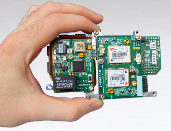
Oxford Technical Solutions (OxTS) has announced the latest addition to its OEM line of inertial navigation systems, the xOEM500. The OxTS is a high-performance GNSS/INS system embedded on a single compact board set. It offers dual GNSS receivers and a high-grade MEMS IMU (inertial measurement unit) to system integrators in an easy-to-integrate 120-g package.
With attractive prices for volume sales, the xOEM500 is one of the world’s smallest tactical-grade INSs available.
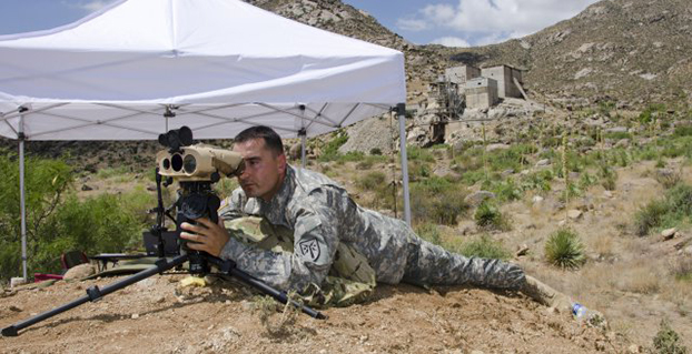
Sgt. 1st Class Justin Rotti, a combat developer from the Training and Doctrine Command Fire Cell, Fires Center of Excellence, uses a developmental handheld precision targeting device during a test at White Sands Missile Range’s 500k test site. White Sands’ terrain and environmental features make it well suited for testing systems of this type. (Photo Credit: John Andrew Hamilton, ATEC)
A new handheld targeting system developed by Northrop Grumman will enable soldiers to engage targets with precision munitions while providing digital connectivity to related military units. The unit has successfully completed developmental testing at White Sands Missile Range in New Mexico, the company said.
The Hand Held Precision Targeting Device, or HHPTD, locates, acquires, designates, marks and enables rapid target engagement with precision munitions and digital connectivity to the Joint Forces engaged in conflicts. The celestial navigation technology integrated in the system delivers improved robustness despite local magnetic variations and GPS-degraded or denied environments.
The HHPTD weighs approximately five pounds and includes a GPS receiver and internal magnetic and celestial navigation technologies, as well as an internal high-definition color day and thermal night vision sensor and an eye-safe laser rangefinder. The system is compatible with external precision azimuth and vertical angle modules and provides precision target location information with digital video output, and digital communication for target location data, plus a capability for a near infrared laser pointer.
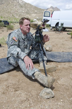
Master Sgt. Rod Larreau, with U.S. Army Special Forces Command (Airborne), uses a targeting device at White Sands Missile Range’s (N.M) 500k Site to identify targets during a test. White Sands provided a wide range of test targets, both in the form of official target boards as well as other facilities, that could be seen from the Soldier’s observation point. (Photo Credit: John Andrew Hamilton, ATEC)
The evaluation of the HHPTD was conducted by the U.S. Army’s Rapid Equipping Force, in partnership with the Army Program Executive Office’s Project Manager, Soldier Sensors and Lasers, and demonstrated the targeting device’s effectiveness in varying terrain and temperatures, ideal conditions for enabling the accurate gauging of the technology’s capabilities.
Northrop Grumman’s Laser Systems business unit is delivering the HHPTDs to support in-theater operations of Department of Defense personnel. “This system is a lightweight, precision targeting device that addresses the targeting accuracy needed by our warfighters to help deliver today’s precision GPS munitions in all operational environments,” said Gordon Stewart, vice president and general manager, Laser Systems business unit, Northrop Grumman. “We have been uniquely successful in producing precision targeting enhancements to our systems through the use of celestial navigation technology.”
The goal is to reduce friendly fire and collateral damage by improving the ability of the soldiers to differentiate between enemy combatants and non-combatants operating in very close proximity to one another.
To best evaluate the soldier capabilities of a targeting system, soldiers at White Sands tested a variety of technologies in varying terrain and temperatures, while recording observations and data in order to help set specific, detailed development goals and objectives for the program. Meeting specified requirements is important, but including soldiers early in the evaluation process ensures acquisition professionals meet Soldiers’ needs to develop suitable equipment.
These “soldier touchpoints” are critical to developing equipment that soldiers trust and will use in combat. “Testing at WSMR [White Sands Missile Range] gives us a better idea of how a system will work when deployed to theater,” said one soldier involved with the test. “I was able to really get a feel for how the technologies would be employed downrange.”
Northrop Grumman Laser Systems has developed the HHPTD and a family of handheld laser target location systems tailored to meet mission requirements in collaboration with FLIR Systems in Goleta, California, General Dynamics GIT in Nashua, New Hampshire, and Wilcox Industries in Portsmouth, New Hampshire.
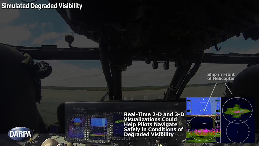
Degraded visibility — which encompasses diverse environmental conditions including severe weather, dust kicked up during takeoff and landing, and poor visual contrast among different parts of terrain — often puts both the safety and effectiveness of tactical helicopter operations at risk. Current sensor systems that can provide the necessary visualization through obscurants struggle with latency and are too large, heavy and power-intensive to comply with military rotary-wing operations.
The Defense Advanced Research Projects Agency‘s (DARPA’s) Multifunction RF (MFRF) program seeks to overcome these challenges and enhance the survivability and combat effectiveness of helicopters facing degraded visibility. The program aims to develop multifunction sensor technology that would enable sensor packages small, light and efficient enough for installation on existing and future helicopter designs. MFRF would enable pilots to:
Take off, fly and land safely in degraded and zero-visibility conditions
Avoid collisions with other aircraft, terrain and man-made obstacles (e.g. power lines)
Improve target detection, identification and engagement
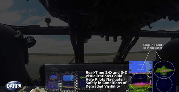
MFRF completed successful flight demonstrations on a UH-60L Black Hawk combat helicopter (see video above) to demonstrate the Synthetic Vision Avionics Backbone (SVAB) technology portion of the program. The SVAB technology demonstration fused millimeter-wave radar with multiple terrain databases and onboard platform navigation to create high-resolution 2D and 3D visualizations of local environmental conditions.
Pilots referred to the visualizations in real time to distinguish terrain features (slope, roughness, landing suitability), detect objects in a landing zone, detect and avoid obstacles, and navigate in GPS-denied conditions. The software architecture of the SVAB also demonstrated plug-and-play sensor control and display.
“These successful tests take us closer to future cost-effective, ‘plug-and-play’ systems that would improve situational awareness and mission effectiveness for manned and unmanned platforms alike,” said Bruce Wallace, DARPA program manager.
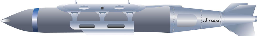
“We expect that the North will finish development of a new precision-guided bomb in the near future because we’ve detected signs that the North has been conducting tests for a few years now,” a military source in South Korea told the newspaper.
The JDAM GPS-guided bomb has a range of 28 kilometers and accuracy of about 13 meters. North Korea’s new bomb is believed to have a range of 10 kilometers.
According to TheChosun Ilbo, military authorities say they detected signs of a fighter jet dropping the bomb over a testing ground in North Korea’s Hwanghae Province earlier this year.
The South Korean Air Force has a variety of precision bombs, including a device with a range of 100 kilometers.
Handheld Group, a manufacturer of rugged mobile computers, has launched the Nautiz X8 rugged PDA. The Nautiz X8 is a handheld computer with superior processing power, screen performance and battery life, the company said. It is built for tough field conditions primarily in GIS, land surveying, public safety, forestry and the military.
Photo: Handheld Group
The Nautiz X8 is built to enable efficient and reliable data collection in tough environments. It has an IP67 ingress protection rating, which means it offers complete protection against dust and sand and can withstand immersion in water. It also meets stringent MIL-STD-810G military test standards for overall durability and resistance to humidity, shock, vibration, drops, salt and extreme temperatures.
The Nautiz X8 features a high-performance Texas Instruments 4470 dual-core 1.5 GHz processor. It has 1 GB of RAM, 4 GB of iNAND Flash and a 5200 mAh Li-ion battery that lasts up to 12 hours on a single charge. It comes with a choice of operating systems — Android 4.2.2 or Windows Embedded Handheld 6.5.3.
The device has a large 4.7-inch ultra-bright capacitive multi-touch screen with chemically strengthened Asahi Dragontrail glass, offering users brightness and protection in any field condition. The unit has an ergonomic design and weighs 490 grams (17.3 ounces).
The Nautiz X8 has a dedicated u-blox GPS receiver, Bluetooth 2.0 and 802.11b/g/n WLAN functionality, as well as connectivity through GSM/UMTS or CDMA phone data transmission. A built-in 8-megapixel camera with autofocus and an LED flash lets users capture visual data quickly and easily. This handheld also features an open architecture and an extension cap system that allows for additional hardware connections such as sensors, radios and other add-ons.
Orders for the new Nautiz X8 can be placed immediately. First deliveries will begin in November.
The Nautiz X8 rugged handheld will be shown first at WEFTEC in New Orleans, followed by InterGeo in Berlin.
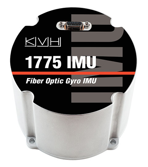
KVH Industries, Inc., has introduced the 1725 Inertial Measurement Unit (IMU) and the 1775 IMU, advanced sensors designed to be integrated into the most demanding stabilization, pointing, and navigation applications. These two new products complement KVH’s successful 1750 IMU and create a complete range of choices for advanced six-degrees-of-freedom (DOF) sensors with enhanced performance. All three products utilize the E•Core ThinFiber technology of KVH’s DSP-1750 fiber-optic gyro (FOG).
“With these three products, system designers and integrators now have a high-performance solution for every application — ranging from manned and unmanned commercial and defense platforms, optical equipment stabilization systems, and pipeline inspection equipment, to autonomous vehicle control and navigation,” said Jay Napoli, KVH’s vice president of FOG/OEM sales. “This line satisfies the performance, size, and price parameters for IMUs in a way that no competitor can match due to KVH’s control over the design and manufacturing process, from creating the fiber to integrating all of the IMU components into the final design. Maintaining complete control of this process, combined with our proprietary technologies, allows KVH to offer a winning combination of innovative solutions, superior quality, and affordable options for nearly every stabilization or guidance application.”
The 1725 IMU features a flexible user interface, with user programmable data output rates from 1 to 1000 Hz. It delivers excellent FOG performance and stability at a price comparable to competitive MEMS-based IMUs. The 1725 IMU is designed for all platforms and navigation or stabilization systems where low cost, high-performance, and high bandwidth are critical for success.
The 1775 IMU is a premium sensor designed to deliver the highest level of performance to meet the demands of platforms requiring superior performance in the most challenging environments. Providing ease of integration for designers of high-level inertial navigation, guidance, or stabilization systems, the 1775 IMU offers a flexible interface with user-programmable data output rates from 1 to 5000 Hz. It includes three axes of magnetometers for automatic gyro bias compensation even in the presence of strong magnetic fields. The 1775 IMU is designed for sophisticated systems and applications where very high bandwidth, low latency, and extreme stability are critical.
Like KVH’s 1750 IMU, introduced in 2012, the 1725 IMU and the 1775 IMU incorporate three axes of KVH’s DSP-1750 FOG, a tiny high-performance FOG integrated with three axes of advanced accelerometer technology. All three IMUs provide excellent shock, vibration, and thermal performance, as well as a compact form factor, KVH said.
KVH controls the entire production process, from creating its own specially designed polarization-maintaining optical fiber to packaging its gyros together in advanced systems for inertial measurement, inertial navigation, and attitude heading reference. As a result, KVH’s open-loop fiber optic gyros offer outstanding accuracy and excellent durability at a lower cost than competing systems, the company said.
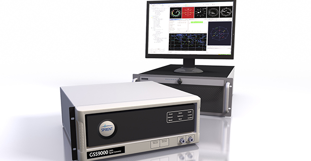
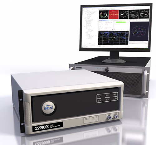
Spirent Federal Systems, a U.S. provider of positioning, navigation and timing test solutions to the government and its contractors, announces that its GSS9000 RF constellation simulator has been reviewed and granted security approval by the GPS Directorate.
Higher dynamic simulations with more accuracy and fidelity are enabled by 1000-Hz (1 ms) System Iteration Rate — a four-fold increase over Spirent’s current GSS8000 product — zero inter-channel bias and a 0.3 mm RMS pseudorange accuracy. The GSS9000 also includes support for restricted and classified signals from the GPS and Galileo systems as well as advanced capabilities for ultra-high dynamics.
According to Spirent, the GSS9000 is being rapidly adopted worldwide by key GNSS system and solution developers and providers because of its flexibility, performance and capability. The GSS9000 builds on the capability and performance of previous solutions from Spirent.
The GSS9000 is highly flexible and can support the widest range of carriers, ranging codes and data streams for the GPS, GLONASS, Galileo and BeiDou as well as regional/augmentation systems. Its flexibility is key to supporting tailored and customizable solutions for specific and unique test needs. Multi-antenna/multi-vehicle simulation, for differential-GNSS and attitude determination, and interference/jamming and spoofing testing are also supported.
Rockwell Collins has successfully received and tracked a Galileo satellite signal using a prototype GNSS receiver designed for secure military use.
In 2013, Rockwell Collins received a $2 million contract from the Air Force Research Laboratory (AFRL) and the GPS Directorate to develop and demonstrate a Secure Software Defined Radio (S-SDR) GNSS receiver capability. By using multiple available satellite signals, improved and more robust signal availability can be obtained, enabling a compatible GNSS receiver to deliver superior position determination that can improve navigation performance and signal availability.
Hosted in a software-defined radio, the S-SDR program will develop the security architecture required for receiver equipment approvals and certifications. The arrival of modernized GPS signals and other global constellations is changing the way the U.S. military and its allies accomplish secure GNSS-based positioning, navigation and timing. The European Galileo constellation coming on line during 2015, including its open signals and secure Public Regulated Service, is expected to provide an opportunity for improved robustness in satellite based navigation, in both commercial and government applications.
“This milestone reinforces our belief that Rockwell Collins is uniquely positioned to produce a navigation receiver that will meet global needs,” said John Borghese, vice president of the Advanced Technology Center for Rockwell Collins. “With decades of experience developing GPS systems and leading edge security architectures, our company continues to be a top innovator in this field.”
More than 35 years ago, Rockwell Collins assisted the U.S. Air Force in developing GPS technology. That legacy continued when the company created the world’s first all-digital miniature GPS receiver under contract with DARPA. Over the years, Rockwell Collins has produced more than 50 GPS products and delivered more than 1 million GPS receivers for commercial avionics and government applications. The GNSS receiver technology being provided for the S-SDR program will continue this legacy of providing leading edge GNSS solutions.
Do you know any conspiracy theorists? You know, those folks who I am sure are well meaning, but see a conspiracy behind every event? Think Mel Gibson in the great 1997 movie with the very imaginative title Conspiracy Theory. Well, the conspiracy theorists have been coming out of the woods following the Galileo launch fiasco, and they are blaming both the Russians and European Space Agency for allowing the Russians the capability to effectively render useless what should have been the first two operational Galileo PNT satellites.
Think about it. The European Union spends more than 17 years gearing up for a launch of the first two operational Galileo satellites, and they leave the final orbit determination to equipment from a country (Russia) that their countries, and the United States, are collectively (European Union) currently sanctioning for numerous treaty and humanitarian violations.
Who knows? Maybe this was all just a big mistake, and there were no overt actions taken by Russia to place the two Galileo satellites in the wrong orbit. Frankly, I have no idea if the final stage was sabotaged or not, but it makes for an interesting theory and gedankenexperiment. It also should serve as a warning to the U.S. government, especially the USAF when it comes to utilizing the remaining Russian rocket engines we have in stock.
I have been to the location where the handover of the Russian rocket motors takes place. The motors are delivered by the Russians and accepted by USAF and United Launch Alliance officials. Then, I have been assured, that the engines are gone over with a fine-tooth comb. Hopefully, there is no opportunity for a motor that has been tampered with passing our inspections, validations and launch certifications. Still, there is always that niggling worry in the back of your mind that won’t go away. So, even if the conspiracy theorists are all wet, and I hope they are, the whole Galileo launch fiasco should still serve as a warning to our National Military Space (NMS) acquisition and launch certification officials. A little extra scrutiny of Russian-manufactured space equipment might be in order.
Of course, there does not have to be a conspiracy. It could be just bad luck or poor workmanship. It is public knowledge that the Russians have had numerous launch and space-equipment failures in recent months, while the U.S. has had more than 115 consecutive NMS launches without a single failure. Indeed, there has not been a single NMS launch failure since the Broad Area Review (BAR) in the late ’90s.
There have been two additional follow-on BARs since and they all recommended greater situational awareness and attention to detail. So maybe the Russians just need a good BAR — pun intended. At any rate we should know in the next few months as there are no fewer than three separate European investigations being conducted as I write this. Let’s hope the conspiracy theorists are all just crying wolf.
Flying for GPS Book Review
This is the title of a new book by an old friend and colleague, Len Jacobson. This is Len’s second full-length book, as he writes copious articles (many for GPS World) and chapters of books for other writers. In my opinion, this is the better of his two books, although the first book was much more technical in nature. It sits on my GPS bookshelf and I refer to it frequently. So maybe this one is just a better read.
When Len’s autographed book arrived, I dove into it and immediately discovered it is as much about Len and his life before and since GPS (BCEGPS and ADGPS if you will) as it is about the Global Positioning System per se. This is certainly not a criticism, merely an observation, since the personal touch makes this book come alive.
Seriously, this book is an unabashed personal history, a travelogue and a history of the GPS program all rolled into one, and although Len cautions readers to only read Part Two if they only want to know about GPS, I maintain that you will miss a great read if you go that route.
Len Jacobson
As I said, I have know Len since about 1975 ,and even though we have known each other for 39 years I had no idea of all the qualifications Len brought to GPS and how his life, after 1975, has revolved around this singular military weapons system.
The book is a tour de force for GPS, but also is about an engineer coming of age in the 1960s during the Vietnam War. Len describes the technology and communications capabilities and programs that made GPS possible. But more than that, he also goes into the personalities, and this may be the highlight of the book for many. He names names when possible, and obscures them when circumstances, personal preferences and legal precedents demand it. Still, most of the time ,if you were around in the halcyon days of Parkinson and Getting, then you know exactly who Len is describing. And even if you don’t know, it is fun to guess.
Len gives some painful insights to the birth pains that GPS experienced — to include the early rejections by both the military and the Federal Aviation Administration (FAA). And his description of the whole Selective Availability saga sheds new light for me on just what took place, and I was there.
Throughout the book, Len describes his life and key roles in self-deprecating terms, and yet acknowledges he was known far and wide. I can personally attest to this, as a GPS proselytizer. There is another word I could use, but since this is a family magazine I will forego the opportunity. Let’s just say that if Len was in the room, you knew you were going to hear about or talk about the latest in GPS technology.
Some of you might describe parts of the book as esoteric trivia concerning GPS, and while that may be true, Len presents it in such a way that you want to file that bit of trivia away for a rainy day and then spring it on your PNT colleagues when they least expect it. For instance, I found it very compelling when Len describes on page 95 the history of the Chinese BeiDou program. I think you will be surprised. I was.
And in the end, many of the companies that Len worked for over the years no longer exist today, such as Figgie, but fortunately many of the people are still around. And Len doesn’t pull any punches. He relates stories of business intrigue, intransigence and even bigotry. He even manages to include the Lacy Peterson murder investigation.
I hope I have piqued your interest, because this is a unique book that everyone who is evenly remotely interested in the history of GPS and PNT in general should read. Highly recommended. Read a quick excerpt from this unique GPS tome on the GPS World website if you have the time.
Happy navigating!
Don Jewell
Until next time happy navigating and remember GPS is brought to you free of charge by the United States Air Force. Aim High!
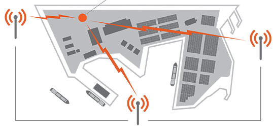
Based on customer use and feedback, Exelis has improved its Signal Sentry 1000 product to include enhanced, user-friendly analytics and alerts. Signal Sentry technology detects and locates sources of intentional and unintentional interference to GPS signals and provides users with actionable intelligence.
Exelis is showcasing Signal Sentry 1000 in Booth 619/621 at the ION GNSS+ conference September 10-12 in Tampa, Florida.
Enriched features of Signal Sentry 1000 include superior sensors that increase detection accuracy to better pinpoint the jamming source, enhanced analytics to recognize patterns of jamming, and easy-to-use history functionality to comprehend where interference happened and to follow its path. Instant reporting of jamming events via text or email so that appropriate resources may be deployed to an incident is also a new feature of Signal Sentry.
“Signal Sentry was developed by Exelis to protect critical infrastructure and to deliver intelligence to police agencies. Since Signal Sentry has been used by law enforcement, we have been able to enhance the products investigative and intelligent-led policing capabilities,” said Carl Slutsky, product line manager for Signal Sentry at Exelis. “Now, users can see patterns such as what happened and when and where it happened to better allocate their investigative resources. Additionally, we added an alert feature to Signal Sentry that provides real-time notice of a GPS jamming event, so law enforcement can dispatch a patrol unit to the precise location of the jamming event.”
Because of the broad availability of low-cost GPS jamming devices on the Internet, the risk associated with signal disruption has increased significantly. GPS jammers are often used by criminals to conceal stolen cars and by commercial drivers whose intent is merely to hide their location from their employer. Truckers who used personal-privacy GPS jammers near shipping ports have caused interference with the signal also used to navigate large ships, which severely compromised safety and the efficient operation of the port.
Signal Sentry leverages GNSS signal domain knowledge and is based upon patented technology developed through the company’s history of designing and fielding electronic intelligence systems. Exelis navigation payloads and components have been on board every U.S. GPS satellite ever launched and have more than 700 years of accumulated on-orbit success.
Loctronix Corporation, a provider of positioning, navigation, and timing (PNT) solutions for GNSS-challenged environments, has unveiled the HGX Interference Detection System (IDS) for identifying and monitoring intentional and unintentional interference sources. The IDS is being demonstrated September 10-11 at ION GNSS+ 2014, in Tampa, Florida.
“The IDS can detect sources of interference ranging between 5 dB and 60 dB GNSS jamming to signal (J/S) ratio. Featuring a novel profiling function, the IDS not only detects, but can identify the type of interference given a database of known/previously recorded profiles,” stated Michael Mathews, Loctronix’ CEO and founder.
According to Mathews, “The greater dependence of GNSS within critical infrastructure — including, transportation, communications, finance and the growing availability of jammers — requires new tools to respond to potential threats. The IDS is the first tool to combine the powerful capabilities of Loctronix Spectral Compression Positioning (SCP) technology for identification and characterization of signals with traditional GNSS signal processing to provide full situational awareness of GPS/GNSS operations. The IDS system will benefit government, military, and commercial/industrial applications wherever there is a critical dependence upon quality GNSS data.”
The IDS was developed using the Loctronix HGX hybrid sensor toolkit along with the company’s ASR-2300 ASR Workbench software defined radio platform. The standard implementation supports L1 GNSS bands and measurement rates of 10 measurements per second. Partner-licensed custom/solutions can support multiple bands (such as L2, L5) with greater bandwidths and measurement rates. Multiple sensitivity modes enable monitoring of sub-thermal and high-power interference.
The HGX toolkit API will be available for specialization of the system for custom/embedded applications and adaptation to other hardware platforms. Visit Loctronix in Booth 422.
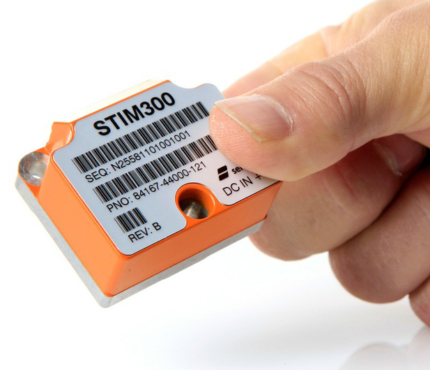
The STIM300 is a small, tactical-grade, low-weight, high-performance non-GPS aided IMU. It contains three highly accurate MEMS gyros, three high-stability accelerometers and three inclinometers. The IMU is factory calibrated and compensated over its temperature operating range.
The STIM series is designed for use below and on the ocean, on land, in the air, and in orbit and space. The STIM300 IMU is well suited for stabilization, guidance and navigation applications in the industrial, aerospace and defense markets. It is a crucial building block for inertial navigation systems in UAVs, AUVs, AGVs, UGVs and ROVs, Sensonor said.
The STIM300 is also used for camera turret stabilization and for use in various handheld devices that require a small IMU to secure operations during GPS outage.