A new emergency locator transmitter for aviation has received Cospas-Sarsat and FAA approvals and is now available for sale. The ELT 1000 by ACR Electronics, Inc., is designed with multiple installation configurations to reduce overall installation cost, the company said.
The electronics maximize frequency stability and power while incorporating a new, built-in GPS navigational interface, the company said. Including GPS data in the emergency transmission allows search-and-rescue personnel to know the location within 100 meters in less than a minute. Designed to accommodate multiple installation configurations, the new ELT 1000 is a quick retrofit for obsolete 121.5 MHz ELTs.
“We are very excited to announce this new ELT to the general aviation market. This is the first new ELT from the Artex family in many years and the first we have designed and certified at ACR. We feel we are bringing an ELT that offers excellent value, along with the highest quality workmanship available to the market,” said Gerald Angeli, president and general manager.
Built under the exacting standards of AS9100C quality certification, the ELT 1000 exceeds all government and regulatory standards including the latest FAA guidelines with its new robust stainless steel mounting strap.
ELT 1000 features and specifications:
Quick and easy retrofit for general aviation aircraft
Single antenna output for emergency transmission on both 406 MHz (Cospas-Sarsat) and 121.5 MHz frequencies (local Search & Rescue)
Enhanced positional accuracy with a built-in GPS interface that does not require aircraft power
Encoded digital message broadcasts aircraft identification/registration and owner/emergency contact details
New stainless steel mounting strap for increased stability that complies with the most current FAA guidelines
Simple self-testing from the cockpit. When combined with 406Test.com, the self-test will provide SMS/e-mail confirmation within seconds that the ELT signal reached the satellites successfully
New hermetically sealed G-Switch for increased reliability.
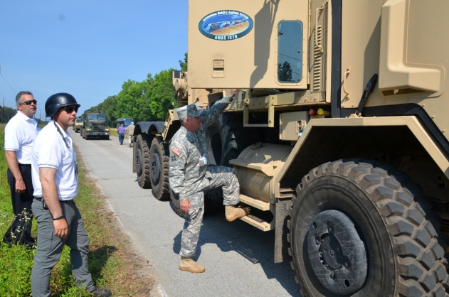
The U.S. Army Tank Automotive Research, Development and Engineering Center (TARDEC) and Lockheed Martin successfully demonstrated additional capabilities of the Autonomous Mobility Appliqué System (AMAS) May 29 at the Department of Energy’s Savannah River Site in South Carolina.
They conducted a driverless line-haul convoy with seven military trucks at speeds up to 40 mph.
The AMAS CAD II demonstration built upon capabilities demonstrated at Fort Hood, Texas, in January, when three unmanned military trucks negotiated oncoming traffic, followed rules of the road, recognized pedestrians, and avoided various obstacles at speeds up to 25 mph in an urban environment.
AMAS is a Joint Capability Technology Demonstrator, or JCTD. That means it’s a joint program between the U.S. Army and the U.S. Marine Corps. The AMAS common appliqué kit consists of the bi-wire active safety kit and the autonomy kit. It uses GPS, lidar systems, Automotive radar, and commercially available automotive sensors to make the system affordable. The AMAS JCTD goal is to standardize these kits across both the Army and Marine Corps and give the warfighter the ability to transform ordinary vehicles into optionally manned vehicles.
Colonel Bruce B. McPeak, Director of Materiel Systems, Combined Arms Support Command, climbs into a Heavy Equipment Transporter (HET) for an autonomous ride-along.
TARDEC is working closely with the U.S. Army Training and Doctrine Command (TRADOC), military users, and the acquisition community to advance the development of autonomous appliqué systems for tactical vehicles and make these capabilities available by 2020.
Autonomy-enabled vehicles will reduce accidents while augmenting the warfighter, and increase capabilities by creating greater stand-off distance from danger, which would make supply distribution safer and more efficient, and provide the flexibility to adapt to tomorrow’s ever-changing and evolving threats.
“The driverless vehicle is coming in both commercial and military applications,” said Bernard Theisen, TARDEC’s AMAS Technical Manager. “The Army is at the forefront of this technology.”
Military and industry VIPs drove alongside the convoy in a bus to watch the unmanned convoy demonstration.
The 30th Space Symposium offered a lot to see and do.
I have said before and will undoubtedly say again, there is absolutely no space-related event in the world today that approaches the sophistication and professionalism of the Space Symposium held annually in Colorado Springs, Colorado, at the five-star Broadmoor Resort. The Space Symposium, carefully engineered and meticulously overseen by the Space Foundation, is truly the premier, must-attend space event of the year on a global basis.
I have been honored to attend 27 of the 30 symposiums, and I hope to attend many more before I shuffle off this mortal coil. Believe me when I say this; it is not merely an oblique reference to health issues. I was hospitalized for four days afterwards with exhaustion among other issues, and the chairman of one of the key companies in space today now has walking pneumonia. So, while this is a major event, you can overdo it, but that is a personal issue and not by any means the fault of the Space Foundation or the event sponsors. Instead, it is an affirmation of the quality and necessity of the event. Indeed, the Space Symposium, with an average attendance of 9,000+, has grown to the point that a single individual just cannot take it all in. It is just not physically possible, whether you are 25 or 65 — believe me, I tried.
Therefore, planning your time at the Space Symposium is essential. Unlike many symposiums where you are able to “play it by ear” and take events as they come, at the Space Symposium if you don’t plan well you will truly miss some crucial space-related event. Plus, it is difficult to relate the quality of the networking opportunities. You have access to space professionals and company VIPs at the Space Symposium that you would never be able to contact in normal daily business circumstances, and the beauty of it is they don’t have an office to escape to. There are so many additional cultural and social events that most VIPs attend, so if you don’t contact your target company VIP, it is probably just for lack of trying. Having said that, it is always good to have your elevator speech polished, because your quantity of time may be limited. You must take advantage of every opportunity. And no matter how well you plan, there are always those chance encounters, which is one of the aspects that make the Space Symposium so worthwhile. Sometimes just the opportunity to rub shoulders and discuss space matters with other professionals is all that’s required; those opportunities were abundant at this year’s symposium.
May Day versus April Fool’s Day
This year circumstances prevailed, and the 30th Space Symposium was held 30 days later than normal. The events that led to that scheduling change are significant in their own right. For instance, I will list just a few events and names; they might initially seem random, but they are intricately related:
Phil Anschutz
Broadmoor Resort
Construction
Renovation
Colorado weather
School schedules
Graduation dates
Space legislation
Sequestration
Colorado governor
Ambiance
Consistency
Education
OK, the list could go on and on, but the point is that the Broadmoor Resort, as a resort, has been around since 1918, or 96 years. The property history actually goes back as far as 1871 and the founding of Colorado Springs by Spencer Penrose, but that is another story for another time. The most recent important facts are that in October 2011, Mr. Philip Anschutz, a local Denver-based billionaire, purchased the Broadmoor, a place he fondly remembered from his childhood. He decided that it needed renovating in the best style of the early 1900 Italian Renaissance — which was always reflected in the older resort buildings on the eastern side of the lake, but was not reflected in the newer western side, with a lack properties. Consequently, the two-plus-year renovation certainly impacted the dates and availability of rooms and services available for the annual Space Symposium. In 2012-13, the event took place in spite of construction, but the 2014 date needed to be moved from April to May to ensure all facilities would be available. Indeed, the formal completion and grand opening after renovations took place was on the Friday preceding the Sunday opening of the Symposium. But then, close only counts in love and horseshoes.
So this accounts for a few words on the list, but the rest are definitely related to the conference itself. For years, many of the non-Colorado space companies and sponsors of the symposium wondered aloud if the second week in April in the foothills of the Rocky Mountains might be a bit early for such an event, since it invariably snowed, usually more than once, on participants sometime during the week-long event. However, the Space Foundation held firm on the dates for many reasons, one of which was the belief that flatlanders just don’t understand that the foothills of the Rocky Mountains are eligible for snow 12 months out of the year. Seriously, we have lived here for going on 25 years now, and we always said we were eligible for snow 11 months out of the year until a couple of years ago, when it snowed ten inches in August. It had been 80+ degrees the day before. So the Space Foundation pretty much ignored the clueless flatlanders and stuck to their guns on the date issue.
But, in all honesty, there is much more to the date debate. The Space Foundation prides itself on education and fostering interest in all things space related. It helps fund numerous space-related institutions, scholarships ands organizations. The future of space and our national heritage as it relates to our future space professionals is a consuming force in the Space Foundation’s mission. In May, most schools in the Rocky Mountain region have been dismissed for the year, and quite frankly, as they discovered this year, the space symposium is significantly diminished if the students, teachers and professors cannot attend. This year the attendance was down almost 2,000 attendees, from 9000+ to 7000+, simply because schools and educators from grade school to graduate school found it difficult to participate. Be that as it may ,the Space Foundation could not ignore Philip Anschutz and the multimillion-dollar Broadmoor renovation, nor the major inconvenience to the guests and attendees. So they reluctantly agreed to move the date to May as a one-time experiment.
The results of that experiment were definitely mixed. On the plus side, the renovations were complete and the transformation was phenomenal — if you had never visited the Broadmoor before, you would not be able to tell anything was changed. Facilities and buildings on both sides of the lake look like they were built in the early 1800s, but with all the modern conveniences of the 21st Century — a truly amazing accomplishment and tribute to Phil Anschutz’s vision. I visited the Broadmoor at least once a month during the two-year renovation, and I was still amazed at the transformation. Nineteenth-century Italian ambiance and 21st-century convenience, what a combination.
Now to the weather. Indeed, there were only a couple of small snow showers in the early morning hours during the week at around 0500, which most everyone missed. But Wednesday’s monstrous mega-hailstorm happened in the middle of the afternoon and was not to be missed, visually, aurally or physically. I was enroute to a meeting with Dr. Mark Crews and company from Ball Aerospace on the East side of the lake when the meteorological freight train struck. Fortunately I was under a huge Broadmoor umbrella at the time, or would have surely suffered a concussion, and that is no exaggeration. Golf-ball-sized hail appeared in biblical proportions (Moses would have been proud), and insurance companies executives, many who were in attendance, could be seen talking rapidly on phones and groaning visibly. Indeed, USAA, my insurance company for the last 50+ years, reported more than 800 automobile and 400 property insurance claims in a 24-hour period following the storm, and many insurance companies sent in their disaster and catastrophe teams. So, all in all, I vote for the occasional light snow in April versus the icy rocks raining from heaven in May. I know it is an anthropomorphic illusion, but it is as if Mother Nature were thumbing her nose at those flatlanders who dared be critical of a few snowflakes in April. On the plus side, the added moisture ensured the fireworks display could take place as planned this year, and it is always a spectacular event over the Broadmoor Lake.
Politically Speaking
Politically, the timing could not have been better for the Governor of Colorado, the Honorable John Hickenlooper, who came south of the Mason-Dixon line and attended the event where he ceremoniously signed significant Colorado State tax legislation that — bottom line — makes it more profitable for all space-related companies to operate in Colorado. Colorado currently ranks third in the nation for space-related income. Many believe it will return to the Avis, or number-two, spot that it held for many years, after this legislation has time to take effect. Current rankings are California first, Florida second, and Colorado third.
Social Events
And last but not least, let’s not forget about the entertainment and social gatherings. There are more breakfasts and luncheons than you could possibly attend. Of course you have to be invited, but if you have something somebody wants, the invites flow. The evening dinners and some social events are much more restricted in nature, but are in truth where much of the real “marketing” and work — read deals — are accomplished.
This year just as last year there is one event that stole the show. Strictly invitation only — last year only 200 select individuals were invited, and this year although the number doubled (word got out), it was still very much the exclusive event. I am speaking of highly coveted invitations to the Connecting Colorado Gala hosted by Braxton Technologies at the Cheyenne Lodge at the Broadmoor, several miles from the main event. There were CEOs, company presidents, CFOs, politicians and wanna-be senators and congressmen. A small chamber music group played quietly in the background, and you could actually talk in a normal tone of voice and be heard. Delicious delicacies streamed out of the world-class kitchen for hours. There were huge roaring fireplaces on the wrap-around deck, lit with torches, and of course lugubrious cigars, champagne and other fine wines and brandy in abundance. The weather cooperated and the stars put on a fine show. Security was clearly evident, and it worked. Because parking is extremely limited and buses provided the majority of the transportation, you could not board the bus without an invitation. There were no gatecrashers at this event. As my highly prized pass to the event clearly stated — Non-Transferrable — some names were checked against photos at the door. It was truly a classy evening, one that will be long remembered and one that absolutely works from a networking point of view, and if you are not networking, then why be there? My hat is off to the O’Neil brothers, Kevin and Kenny, as well as their CEO Frank Backes. It was a class act, the place to be, and they literally showed every other company at the symposium how it should be done.
We haven’t even discussed all the announcements and events that took place at the 30th Space Symposium, and yet if you were there, you saw seamless million-dollar renovations at a major five star resort, all of your closest buddies in the space world, as well as VIPs you have been trying to get in to see for years, and meteorological and man-made fireworks second to none — along with networking opportunities that frankly only occur once a year at this prestigious event.
I was able to meet with and have lengthy conversations with many VIPs from major space companies, and there are some exciting announcements to come. Believe it or not, some companies want to get out of the government space business — frankly, seques-castration has scared them away. They no longer want to bet the future of the company on congressional budgets. Certainly understandable. Then there are companies that have been out of or momentarily unsuccessful in the GPS/PNT business and are anxious to get back in the game. There are groups of companies that briefed me on proposals that will simply amaze you, and be assured I am doing my best to obtain permission to write about those opportunities. These stories and conversations with VIPs are just too important to give short shrift, so I will be reporting on them in future columns.
Now let’s address the huge shift in Who’s Who in Military Space. The national military space landscape is changing dramatically and is being led by the imminent retirement, in August, of my long time friend and colleague General William Shelton. Willie will retire in the Colorado Springs area and be replaced as the Commander of AFSPC by Gen (S) John Hyten, who I have also had the pleasure of knowing and working with for the past 20 years. Indeed, almost all the major space players in Air Force Space Command and at SMC are changing and those that remain are in the most part good guys, like Colonel Wild Bill Cooley and Mr. David Madden at SMC who understand this business and can be trusted to do the right thing. However, be advised the changes are still pervasive. A friend emailed me just this week and asked me for info on all the significant changes in the Command that I knew about, that affected the continuity of the national security space mission. Just off the top of my head, I came up with 14 moves and retirements — so you get the point.
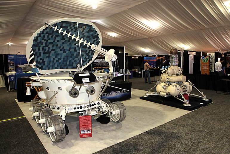
A Lunokhod Rover from the Kansas Cosmosphere and Space Center on display at the Space Symposium.
One of the major changes concerns the GPS IRT (Global Positioning System Independent Review Team), which John Darrah and I co-founded in the Chief Scientist Office at HQ Air Force Space Command just over 19 years ago in May. We decided that in order to operate totally independently, the IRT needed to be administered by a truly autonomous organization, so the IRT was designated to be tasked by the commander of AFSPC. For a time, this was the Undersecretary of Defense for Space through the auspices of an FFRDC (Federally Funded Research & Development Corporation) think tank, known as the Institute for Defense Analyses or IDA. During the last 19 years the IRT conducted studies and helped solve thorny space issues, mostly related to GPS and PNT, for eight commanders of Air Force Space Command and for key officials in the Department of Defense. Our first chairman was none other than the late Dr. James Schlesinger, who previously served as chairman of the Atomic Energy Commission, director of the CIA, U.S. Secretary of Defense, and the U.S. Secretary of Energy. He also served and advised eight presidents, and at the time of his passing was serving (since 2007) as the chairman of the National Space-based Positioning, Navigation, and Timing (PNT) Advisory Board. The PNT Board is composed of recognized GPS experts from outside the U.S. government that advise the deputy secretary level PNT Executive Committee in its oversight management of the GPS constellation and its governmental augmentations.
No sooner was the IRT formed under Dr. Schlesinger’s leadership than it was given a non-GPS or PNT-related task, and it proved to be a major task indeed. The task was to form a Broad Area Review panel for space launch and determine why the U.S. had, over the period of a few months, put more than $4 billion worth of space hardware into saltwater versus the vacuum of space. Since that original and subsequent BAR, the U.S. has not had a single complete launch failure in over 120+ launches, a record that cannot be claimed by any other space-faring nation and testament to the value of world-class, truly independent review teams that tell it like it is, warts and all.
Dr. Schlesinger represented the caliber of people that serve on the IRT, which still exist today as an independent panel led by Major General (USAF, Retired) Robert Rosenberg under the auspices of the Independent Strategic Assessment Group, also administered by IDA and chaired by former Chief of Staff of the USAF and former head of IDA, General Larry Welch (USAF, Ret).
The landscape and leadership are changing, but the National Security Space mission remains the same. Hopefully the national leadership will be able to adapt and perceive the current changes as opportunities – because while brilliant and intelligent leaders matter, people matter. Success should never be about personalities but rather about integrity, professionalism, and dedication – about doing the right thing and making the right decision every time.
What Is Don Reading?
This month I only have room for one important tome: Lindbergh by A. Scott Berg.
I initially read this wonderful volume several years ago and enjoyed it very much. I read it again recently because of the Time and Navigation display at the Smithsonian that piqued my interest in all things related to time and navigation through the ages. Lindbergh’s first solo flight across the Atlantic Ocean was not a flight of fancy, but rather a flight of daring as well as one of historical significance from a world-class aviator. He did not take any over-water navigation classes until after the event! As the jacket states, “…here at last is the definitive life of one of the most legendary, controversial, and enigmatic figures in American history.” I hope you enjoy it as much as I did. Highly recommended.
Until next time, happy navigating, and please make your plans now to attend the 31st Space Symposium in 2015. I hope to see you all in Orlando, Florida, at the ION JNC (Institute of Navigation Joint Navigation Conference) event later this month (June 16-19, 2014).
Ethertronics has unveiled EtherHelix GPS, a small, stand-alone, Right Hand Circularly Polarized (RHCP) external GPS antenna. Measuring 35 mm in length, the EtherHelix GPS is 27 percent shorter than other antennas on the market with no performance trade-offs, the company said. It is designed for high-performance, mission-critical devices such as walkie-talkies, tough books, tough tablets, first responders, public safety, military applications and more.
EtherHelix can be tuned for various satcom frequencies and various polarizations (RHCP or LHCP). EtherHelix GPS is designed using Ethertronics’ patented Isolated Magnetic Dipole (IMD) technology providing high performance and efficiency in a small form factor.
EtherHelix GPS has a high tolerance to frequency shifts given the technology’s high RF isolation, which is designed to resist antenna detuning that can otherwise impair reception. EtherHelix GPS provides exceptional coverage inside buildings, vehicles or other areas where weak signals and signal reflection occur, the company said.
“GPS capabilities are critical for first responders and military applications. It is imperative that the antennas used in these devices are high-performance, small and rugged,” said Olivier Robin, general manager Americas and Europe at Ethertronics. “EtherHelix GPS is the most recent example of Ethertronics’ leadership in developing industry-first RF solutions to provide manufacturers with a way to differentiate their products and stand out in a competitive market. Already we have seen interest in our new EtherHelix GPS antenna given its best-in-class performance coupled with its smallest occupied volume.”
Given its reduced weight and size — 11.8 g and 35 mm long by 15 mm in diameter — manufacturers benefit from simpler integration for an array of GPS devices, Ethertronics said. In addition, the new GPS antenna’s capabilities include high selectivity, which minimizes the need for additional filters. EtherHelix GPS’s ruggedized design includes IP-68 protection from dust and water, as well as a standard SMA male connector for easy integration. The RoHS Compliant antenna is designed and manufactured in the United States.
EtherHelix GPS is commercially available now and is the first in a series of antennas for mission-critical applications.
Globecomm, a global provider of communications solutions and services, has received a contract extension from NATO Communications and Information Agency (NCI Agency) valued at $9.6 million to extend communication services and onsite support for the company’s previously deployed GPS-Based Force Tracking System (FTS).
The FTS provides NATO with high levels of tracking data and messaging traffic. It enables NATO to identify where its personnel are located at all times, identify other multinational forces, and have the ability to do so in routine and operational situations. This is critical in assisting with the identification of friendly forces and helps prevent “blue-on-blue” incidents, the company said.
Globecomm previously announced approximately $74.7 million in contracts from NATO for this project to design and install a GPS FTS, bringing the combined contract value to approximately $84 million.
“Globecomm is pleased to receive this contract extension to continue to deliver this important service,” said Paul Knudsen, vice president of Globecomm’s Eastern Atlantic Team. “We completed an upgrade of this system last year under a separate contract that was previously announced. Globecomm has been providing this service since 2007.”
The global space economy grew to $314.17 billion in commercial revenue and government budgets in 2013, reflecting growth of 4 percent from the 2012 total of $302.22 billion, according to The Space Report 2014. The report was issued this week by the Space Foundation during the 30th Space Symposium being held this week in Colorado Springs, Colorado. GPS World Defense Editor Don Jewell is providing coverage from the symposium.
Commercial activity — space products and services and commercial infrastructure — drove much of the increase. From 2008 through 2013, the total has grown by 27 percent. Commercial space products and services revenue increased 7 percent since 2012, and commercial infrastructure and support industries increased by 4.6 percent.
Government spending decreased by 1.7 percent in 2013, although changes varied significantly from country to country. Substantial space budget cuts in the United States outweighed gains in Canada, India, Russia, South Korea, and the United Kingdom, all of which increased budgets by 25 percent or more.
These new global space economic numbers come from the Space Foundation’s publication, The Space Report 2014:The Authoritative Guide to Global Space Activity, which was released today. Data was compiled from original research and a wide variety of public and private sources, and analyzed by Space Foundation researchers.
Key Findings
The 160-page book contains worldwide space facts and figures and is illustrated with photographs, charts and graphs. Within are myriad examples of the benefits of space exploration and utilization, the challenges facing the space sector, the opportunities for future growth and the major factors that shape the industry. In addition, The Space Report includes an overview of each sector, definitions, and up-to-date information on space infrastructure, facilities, launches and programs.
Following are just some of the many interesting facts and analyses found in The Space Report 2014: The Authoritative Guide to Global Space Activity:
Launches and Satellites
81 launch attempts took place in 2013, an increase of 4 percent from the 78 launches in 2012 (and above the five-year average of 79 launches per year).
The majority of these launches were conducted by Russia (32 launches), the United States (19), China (15), and Europe (7).
After two years of conducting fewer launches than China, the United States rose again to second place, partly due to an increased operational tempo as U.S. commercial providers launched cargo resupply missions to the International Space Station.
New launch vehicles made their first flights (or first successful flights) in five countries–the Antares and Minotaur V in the United States, Soyuz 2.1v in Russia, Kuaizhou in China, Epsilon in Japan, and KSLV-1 (also called Naro-1) in Korea.
The number of satellites launched during 2013 increased by nearly two-thirds compared to 2012. This was largely due to a significant uptick in the number of satellites with masses below 91 kilograms (200 pounds). These microsatellites constituted more than half of the 197 satellites launched in 2013.
Many of the microsatellites were short-lived technology demonstrations, but there is a considerable degree of interest in future possibilities for constellations of small satellites that provide valuable services on an ongoing basis.
Workforce
According to U.S. Bureau of Labor Statistics (BLS) data, the size of the U.S. space workforce declined for the sixth year in a row, dropping 3.5 percent, from 242,724 in 2011 to 234,173 in 2012 (the most recent full year for which data is available) – a decrease of about 8,500 workers. However, the changes varied by sector, with some portions of the space industry growing while others contracted.
The United States’ National Aeronautics and Space Administration (NASA)’s civil servant workforce remained essentially flat, declining by less than 1 percent to reach 18,068 in FY 2014. Although the workforce continues to become more concentrated at higher ages, NASA has experienced moderate success in recruiting and retaining young workers below the age of 35 during the past five years.
Both Europe and Japan saw increases in space workforces; the European industry workforce grew by 1.5 percent in 2012, adding approximately 500 employees; in Japan, the overall workforce grew by 11 percent, while employment at the Japan Aerospace Exploration Agency (JAXA), Japan’s government space agency, dropped.
The Space Foundation Index
As of December 2013, the Space Foundation Index was 94.22 percent above its value at inception in June 2005. The Space Foundation Infrastructure Index outperformed the S&P 500 and the NASDAQ during 2013, while the main Space Foundation Index and Space Foundation Services Index did not perform as well as the NASDAQ, but substantially better than the S&P 500. These indexes, which are updated daily on the Space Foundation website, are easy-to-understand mechanisms for gauging the financial performance of space industry companies listed on U.S. stock exchanges.
The Space Report is published annually by the Space Foundation, which works with a leading aerospace consulting firm, Futron Corporation, to research and analyze government and industry trends in space activity. The stock market analysis is provided by ISDR Consulting, LLC, a management consulting firm specializing in the space, satellite and technology sectors.
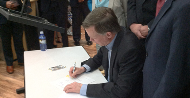
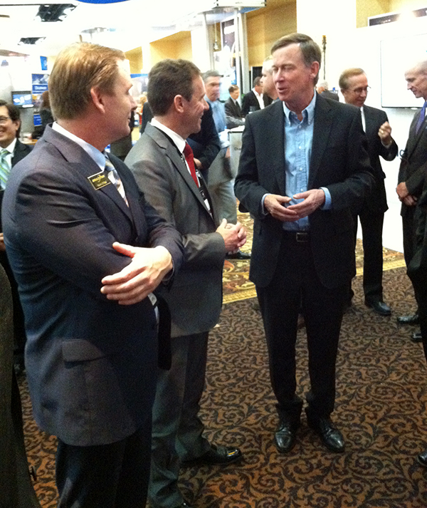
Colorado Governor John Hickenlooper signs a space-friendly bill at the 30th Space Symposium in Colorado Springs.
Colorado Ranks Third in Space-Friendly States
Governor John Hickenlooper (D) of Colorado made the trek from the statehouse in Denver yesterday to sign key space-friendly Colorado legislation at the 30th Space Symposium in Colorado Springs. The world’s largest annual space symposium takes place at the famed Broadmoor Resort in Colorado Springs and nominally draws a crowd of space aficionados and professionals, government and civilian alike, approximately 9,000 strong. Colorado House Bill #1178 is titled the “Sales And Use Tax Exemption for Qualified Property Used in Space Flight,” and it is hoped this legislation will help expand aerospace industry growth in Colorado. Spokesmen from the governor’s office and Tom Clark from the Colorado Space Coalition stressed that Colorado currently has the nation’s third-largest aerospace economy, and the new tax-exemption bill is part of Colorado’s strategic initiatives to support and grow one of its strongest industries. Indeed, Colorado Springs is known in government circles as the Home of Military Space. Several key space industry experts (both government and civil) present at the bill signing stated that the new tax exemption will add an important boost to keep Colorado ahead of the competition and further stimulate the state’s massive aerospace economy. Colorado is known as a national hub for geospatial technologies, remote sensing and satellite-based services. The space services and technology providers comprise the largest category of the state’s space economic activity, bringing in $6.3 billion in annual revenue. Currently, the Colorado space-based revenue is growing at a steady 8 percent annual rate. In conversation with Tom Clark, he admitted that in years past, Colorado has actually occupied the number-two raking for a state’s space-based economy, but was recently surpassed by Florida, which has similar tax-friendly legislation on the books. Clark was confident that with the new legislation Colorado would, like Avis, soon be number two again.
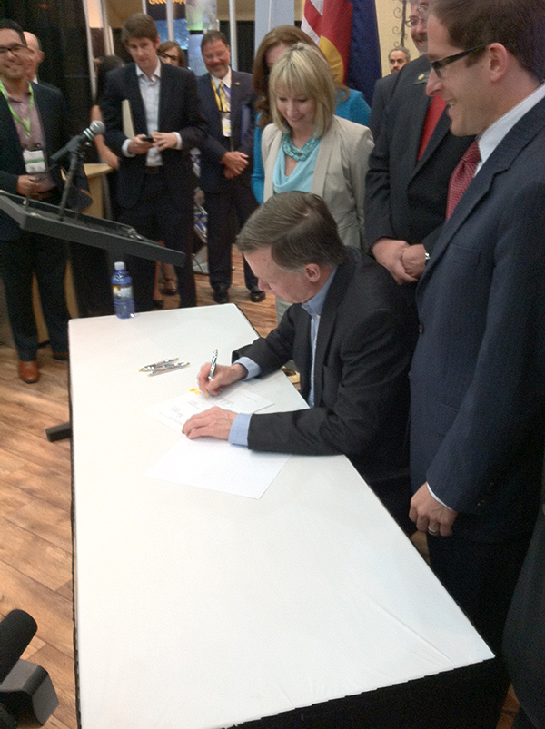
Colorado Gov. John Hickenlooper discusses space matters at the 30th Annual Space Symposium with Braxton Chairman of the Board Kevin O’Neil and Braxton CEO Frank Backes.
Report from the 30th Annual Space Symposium, May 19-22, Broadmoor Resort, Colorado Springs, Colorado
For the past five years, the first day of the National Space Symposium — now known simply as the Space Symposium, the largest symposium of its kind in the world — has started with an entire day dedicated to discussions of the cyber domain as it pertains to the DoD and civilian industry. The annual event highlights presentations from the major civilian cyber players and the senior cyber commander for the DoD, military services and government agencies. Several of the now-senior military officers worked for or with me as junior officers at some point in the past, and while that is an age-related humbling experience, it also makes me proud of them at the same time.
One major talking point, among many, is crystal clear: the U.S. government and civilian enterprises alike understand that cyber security is a critical mission and that cyber warfare, especially from a nation-state point of view, is a credible and viable threat to every government and civilian program and and to everyone today.
Major General Kevin McLaughlin, currently the commander of 24th Air Force and AFCYBER, the major command that takes cyber warfare to heart as a major mission, is one of those young officers in my past that make me proud today. Kevin was the luncheon speaker, and he put the Air Force role for cyber warfare in perspective as well as explaining how the Air Force role is integral to the overall Defense Cyber Enterprise. This integration role may seem like a small matter, but General McLaughlin’s explanation of Air Force and DoD cyber and IA (Information Assurance) synergy is critical to the success of his organization and mission.
This is critical because throughout my Air Force career and even today I constantly encounter commanders that are quick — too quick in my book — to explain, usually with great passion, why their particular mission(s) are critically important and “unique” to the Air Force writ large enterprise. Unfortunately, history shows us that “unique” organizations within services do not always fare well in budget scenarios, especially seques-castration budgets.
In my humble but experienced opinion, the senior officers commanding these “unique” organizations, be they cyber or otherwise, would fare far better if they conformed to Air Force budget requirements and still conducted their day-to-day unique missions just like a fighter pilot and fighter sortie. By that I mean you never know what you will encounter on a fighter sortie. You never know what the enemy will throw at you but you can rest assured that any plan, no matter how well conceived, will not survive initial contact with the enemy. The plan always changes and will hopefully be successful, but only because of flexibility, which has been described as the key to air power, and certainly not because of the “plan.”
So, I was assured when Gen. McLaughlin described “A Day in the Life of a Cyber Warrior” just as I would a fighter sortie. Prepare for the known threat and expect the unexpected. Be innovative and flexible, and you may win the battle and live to fight another day, because make no mistake about it, cyber warfare is a life-and-death struggle.
Fortunately, there do seem to be solutions that work, and a key point that was made numerous times by various speakers is that the small, small, usually local cyber warrior company is often times much more successful than the security behemoths that tend to get bogged down in their own administrative minutia. One of the companies mentioned was NDP, a small cyber and IA company in Boulder, Colorado, known for its work slaying the cyber dragons attacking the well-known SBIRS (Space Based Infrared System) program. The story goes that NDP, with only 50 employees, took on major global SBIRS cyber and IA issues and made it look simple. It is always the real experts that make it look simple. The chairman of one of panels really put it in perspective when he opined, “Would you really want Raytheon or Boeing providing anti-virus software for your home computer? Probably not! No slight to the mega companies intended, but I would go with the local, flexible and responsive small company, like NDP, every time.”
Thankfully, a lot of what I heard this year, as opposed to years past, conforms to the scenario I just described. Bad cyber actors (villains), local or nation state, are anticipated, and while the white-hat cyber warriors win more times than they lose, it is clear there is currently no panacea for cyber and IA threats — just hard work, diligence and flexibility to hopefully win the conflict.
Friday’s launch of a Delta 4 rocket carrying the latest GPS satellite was tracked via GPS itself instead of by radar, reports Spaceflight Now in an article.
United Launch Alliance’s Atlas and Delta rockets are transitioning to GPS metric tracking for range safety functions, which protect the public and property should a launch vehicle veer off course. The move is a money-saving upgrade to the military’s aging range infrastructure.
A special avionics system on the launcher transmitted the location. For decades, most rockets launching from Cape Canaveral, Florida, and Vandenberg Air Force Base, California, have been tracked by C-band radar.
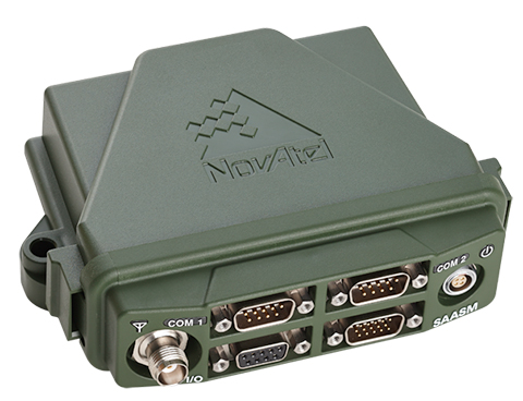
NovAtel has launched the FlexPak-S GNSS SAASM enclosure. The FlexPak-S contains a NovAtel dual-frequency OEM625S receiver card integrated with L-3’s XFACTOR Selective Availability Anti Spoofing Module (SAASM) onboard. The FlexPak-S is security-approved by the GPS Directorate for operational use.
NovAtel made the announcement at AUVSI’s Unmanned Systems 2014, being held this week in Orlando, Florida.
When keyed by authorized defense integrators, the FlexPak-S provides centimeter-level Real Time Kinematic (RTK) Precise Positioning Service (PPS) solution by taking the raw measurements from the XFACTOR SAASM and applying them to NovAtel’s Advanced RTK algorithms. The FlexPak-S can be handled as unclassified when keyed.
In the Standard Positioning Service (SPS) fallback mode, the FlexPak-S continues to provide centimeter-level accuracy by utilizing NovAtel’s dual-frequency civil GNSS positioning engine. FlexPak-S’ fallback mode is configurable for GPS or GPS+GLONASS. Adding GLONASS tracking increases position performance in obstructed sky conditions, which is a benefit for unmanned ground vehicles.
FlexPak-S was developed for size-constrained environments, so it’s compact and lightweight, NovAtel said. Despite its size, the rugged GNSS enclosure has been engineered to ensure reliability, even in harsh environments. The IP67 housing is water-resistant and operates in a wide temperature range. FlexPak-S also allows for easy integration with standardized hardware connections and NovAtel’s comprehensive set of software commands. The SAASM position is provided via a dedicated communication port, as well as through NovAtel’s software command protocol, allowing for maximum flexibility. FlexPak-S uses the same form factor as the FlexPak6 design.
“FlexPak-S is a great option for customers looking for a reliable solution in environments where size is critical, like UAV and robotics applications,” said Shane McEwen, product manager for NovAtel Enclosures. “With standard software and hardware connections, integration is simplified so there is a quicker time to market.”
At the ENC-GNSS Conference in Rotterdam, we delved into actions necessary to officially use EGNOS (giving me déjà vu from WAAS’s early days), heard sage words from Brad Parkinson, the father of GPS, and, on the last day, saw amazing proof of a claim many of us initially thought was outrageous — that differential (DLoran) with modern monitoring can result in consistent horizontal accuracies approaching five meters on a moving platform.
When I was asked if I could cover the European Navigation Conference 2014 (ENC-GNSS) in Rotterdam, The Netherlands, it took me about two seconds to answer in the affirmative. Let’s see… Travel to Europe in the spring, visit The Netherlands — my old stomping grounds where my daughter was born — see miles and miles of beautiful Tulips in bloom, and visit with some old friends. Gee, what a tough decision. Oh, and of course, cover the ENC. Almost forgot that
Seriously, my primary purpose, of course, was to cover the ENC and associated events such as the Resilient PNT Forum and a meeting of the European Maritime Radionavigation Forum (EMRF), but literally miles and miles of brilliant red, white, and yellow tulips interspersed with ancient windmills are hard to ignore. But I digress.
In past years the ENC, with approximately 400 attendees, has been naturally dedicated to European PNT matters, and in reality it concentrated almost exclusively on Galileo with a slight mention of EGNOS. That was about it. This year, the venue was the same, but the program was more open, with presentations on PNT augmentations such as EGNOS and DLoran, and maritime navigation to include radar and inertial systems.
For those of us that have been in the PNT (positioning, navigation and timing) or merely the navigation business, say, for the past 40+ years or so, in some respects it was more than slightly reminiscent of times past. As the great American octogenarian baseball philosopher and malapropism aficionado extraordinaire, Yogi Berra, once said, “It was déjà vu all over again.”
European Maritime Radionavigation Forum
The Port of Rotterdam today (2014).
The EMRF was the first official function to kick off in Rotterdam. When you consider that Rotterdam is one of the busiest ports in Europe and had been around since 1340, you would naturally expect one of the main conversations at the EMRF to concern the port of Rotterdam and navigating in less-than-perfect conditions. The Netherlands is known as the Low Country, and that is as an apt description since most of the country is below sea level — hence the persistent fog, dikes, sea walls, and windmills that pump water and grind grain and all those good things. Today, the modern versions of those windmills are huge — twenty stories tall — and generate electricity. Many of them are close to shore so precise navigation in foggy conditions is even more critical than in times past.
The main topic of conversation at the EMRF revolved around the actions necessary to officially use EGNOS (the European Geostationary Navigation Overlay Service) as a precision and official safety-of-life augmentation for GPS (similar to WAAS, Wide Area Augmentation System) and Galileo.
During those discussions, I swear when I closed my eyes, except for the accented English, I was propelled backward almost 20 years to discussions of WAAS as a safety-of-life system, not for maritime but for aviation purposes. Still, the dialogue and heated discussions echoed down through the years almost verbatim. The main difference, of course, being that in the U.S. it was 20 years earlier, we were embarking on virgin territory, and we had only ourselves, one nation, to debate. Whereas the Europeans are fighting the same battles two decades later, with a system that is purposefully almost an identical copy of WAAS technically, and they are working for maritime and aviation certifications simultaneously. And not with just one nation but the entire European Union. A truly daunting task.
The EMRF website is sponsored by Trinity House in London, which is responsible for the safety of [English and European] shipping and the well being of seafarers, which have been their prime concerns ever since Trinity House was granted a Royal Charter by Henry VIII in 1514. I planned to list the EMRF website for your further edification, but since the latest news on the site concerns the upcoming January 2011 EMRF meeting in Paris, I thought it was best left to molder in obscurity. The website, not the EMRF.
The bottom line for the EMRF is that while it fills an important role where EGNOS and maritime navigation are concerned, it still has a lot to learn and could benefit greatly by lessons learned from WAAS. However, I personally see no indication that will happen, so we wish them luck. Many of us are standing by to assist if asked. Even if it is only, “Been there, tried that, and here is why it did or did not work.” Quod homo non sit Island.
Resilient PNT Forum
I was happy to see Dana Goward (USCG Ret), the head honcho at the Resilient Navigation and Timing Foundation, which conducted the Resilient PNT Forum at ENC 2014. Dana’s forum, which took place just before the official ENC 2014 kickoff, concentrated on the need for and strategies to achieve resilient position, navigation and timing (PNT) services. The event was well attended, and was jointly hosted by the European Group of Institutes of Navigation, the International Association of Institutes of Navigation, and the International Association of Marine Aids to Navigation and Lighthouse Authorities. There was no charge to attend the event, and the collaboration proved interesting, especially since Dana really wanted to talk eLORAN and GPS/Galileo augmentations.
Dana is retired U.S. Coast Guard and worked many years supporting LORAN-C and the USCG Navigation Center. Dana showed a brief video of his recent testimony before the U.S. Congress, where he lobbied for a cessation of the destruction of LORAN-C towers and their associated infrastructure. If recent congressional actions are any indication, he has been somewhat successful in that regard. Now all that is left is to help the U.S. Congress, services, and agencies realize how badly the United States needs LORAN as a backup, enhancement, and augmentation to GPS and other space-based PNT services on a global basis. No small task, but it is a task that Dana Goward and the Resilient Navigation and Timing Foundation have strapped on, and we wish them the best. Plus, as you will see later, a surprise presentation at ENC-GNSS may have given Dana and his cause just the boost they need. Keep reading.
As it turns out, many others thought these non-Galileo presentations were timely topics as well, and the discussions were enlightening, especially the Resilient PNT Forum keynote address by Professor David Last. Among many other titles he holds, Last is a consultant engineer and expert witness specializing in radio navigation and communications systems. He is a professor emeritus at the University of Bangor, Wales, and past president of the Royal Institute of Navigation. He acts as a consultant on radio-navigation and communications to companies and to governmental and international organizations and is active as an expert witness, especially in forensic matters concerning GPS.David and I are old friends, and it is always enlightening and entertaining to hear him speak. On this occasion, Professor Last spoke eloquently and authoritatively concerning the ubiquity of GPS/PNT and the resultant and inherent vulnerabilities of space-based systems. David made the essential point that while GPS remains the sine qua non of PNT, it is still vulnerable and subject to failures as are all space-based PNT systems, the recent GLONASS debacles being prime examples. More on these unfortunate Russian examples of PNT vulnerability at a later date.
David pressed the issue, as he has many times, that we desperately need a ground system or many different ground-based augmentations, backups, and enhancements to ensure that the user is never without navigation and timing data at a critical juncture, such as navigating through an insanely busy commercial port in thick fog.
This theme was carried forward in the ENC-GNSS very adroitly by none other than Dr. Bradford Parkinson, the Father of GPS. Dr. Parkinson spoke at length on the need to “Protect, Toughen, and Augment GNSS” against all enemies, be they manmade or natural. Brad made the point, with all due credit to Will Rogers, that “Rumors of GPS’ death are greatly exaggerated.” Indeed, the GPS constellation has never had more satellites on orbit, in residual status, and spares in the barn than we do today. The SIS or Signal In Space has never been more accurate, and the GPS atomic reference systems have never been more stable than today, and yet GPS remains incredibly vulnerable. But take heart, as Dr. Parkinson is convinced “There are actions such as PTA that can be taken to safeguard PNT for all users.” We will cover Dr. Parkinson’s 60+-slide presentation in depth at a later date.
Surprise! Loran Is the Answer
The big surprise came on the last official day of the conference during a group of alternate PNT presentations co-chaired by Dr. David Last. The rather startling enhanced differention LORAN (eDLoran) presentation was given by Professor Durk van Willigen, representing his colleagues René Kellenbach and Cees Dekker of the Dutch consulting firm Reelektronika, and Wim van Buuren of the Dutch Pilots’ [ed. maritime] Corporation, who helped with the DLoran research and authoring of the paper for the ENC presentation.
Professor van Willigen made what many of us initially thought was an outrageous claim, and then amazingly went on to prove that enhanced differential Loran with modern monitoring produced consistent horizontal accuracies approaching five meters on a moving platform. Needless to say, Professor van Willigen, who teaches at the Delft University of Technology in The Netherlands, was mobbed at the end of his presentation, but I did manage to catch him for a few minutes afterwards. Since then, GPS World Editor-in-Chief Alan Cameron has spoken with Professor van Willigen at length, and the result is the first of what I am sure will prove to be numerous articles on eDLoran in GPS World.
Shipboard DLoran receiver installation (orange boxes on rails).
One would hope that with this rather startling improvement in differential Loran accuracy and the decision by the U.S. Congress to halt the destruction of Loran-C infrastructure in North America, that there might once again be a future for Loran, especially eLoran and/or DLoran in North America, and hopefully globally as well.
As Professor David Last in his best imitation of John Cleese might say, “It is the answer to a maiden.s prayer.”
Until next time, happy navigating. I hope to see you all at the 30th Space Symposium May 19-22 in Colorado Springs at the Broadmoor Resort. More than 10,000 attendees are expected, and I hope you will be one of them. Stop by the GPS World booth and say hello.
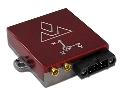
VectorNav Technologies has introduced its VN-300 dual-antenna GPS-aided inertial navigation system (GPS/INS). A follow-on product to the VN-100 IMU/AHRS and VN-200 GPS/INS, the miniature, high-performance VN-300 enables a wider range of applications through the incorporation of GPS compassing techniques.
The VN-300 can be used in a wide variety of industrial and military applications, and is well suited for size, weight, power, and cost (SWAP-C)-constrained applications such as unmanned vehicle systems; antenna, camera and platform stabilization; heavy machinery monitoring; robotics; and primary or secondary flight navigation, among others. The VN-300 will be on display and available for review at VectorNav’s booth #330 at AUVSI in Orlando May 13-15.
Incorporating the latest MEMS sensor technology, the VN-300 combines 3-axis accelerometers, 3-axis gyros, 3-axis magnetometers, a barometric pressure sensor, two GPS receivers, and a low-power microprocessor into a rugged aluminum enclosure about the size of a matchbox. When in motion, the VN-300 couples the position and velocity measurements from the onboard GPS receivers with measurements from the onboard inertial sensors to provide position, velocity, and attitude estimates of higher accuracies and with better dynamic performance than a standalone GPS receiver or Attitude Heading Reference System (AHRS).
The dual GPS receivers incorporated into the VN-300 provide the added benefit of accurate True North heading measurements when the sensor is stationary through the use of GPS compassing techniques, the company said. The VN-300 is designed for applications that require a highly accurate inertial navigation solution under both static and dynamic operating conditions, especially in environments with unreliable magnetic heading and good GPS visibility.
VN-300 Differentiating Features:
The VN-300 has small size, low weight, and low power requirements.
With Development Kits priced around $5k USD, the VN-300 is a fraction of the cost of similarly performing dual-antenna GPS/INS systems and is competitively priced with other MEMS-based GPS/INS systems that do not provide the dual-antenna moving baseline RTK features.
The GPS compass feature coupled with the GPS/INS capabilities on the VN-300 enables applications that require high-accuracy position, velocity, and attitude measurements under both static and dynamic operating conditions.
The algorithms on board the VN-300 enable applications to seamlessly transition between static and dynamic operations without having to collect extended stationary measurements or perform specific dynamic maneuvers in flight for attitude alignment.
The VN-300 incorporates a “True INS Filter” that does not force any requirements on alignment of the sensor to the velocity direction of a platform or specify the orientation of the sensor for initial alignment.
“The VN-300 is unique in that it provides a complete, high performance GPS-aided navigation solution under both stationary and moving conditions, all in a miniature and cost-effective package,” said VectorNav President, John Brashear. “By addressing some of the most difficult issues users face when trying to integrate an inertial navigation system — high cost; large size, weight and power; unreliable magnetic environments; and restrictive operating requirements — the VN-300 will enable an unprecedented number of applications.”