Artist’s concept of the nextgen GPS III satellite (courtesy of the USAF).
Lockheed Martin and Raytheon Company successfully completed the third of five planned launch and early orbit exercises to demonstrate the launch readiness of the world’s most powerful and accurate Global Positioning System (GPS), the U.S. Air Force’s next-generation GPS III satellite and Operational Control System (OCX).
Successful completion of Exercise 3, on August 1, was a key milestone demonstrating Raytheon’s OCX software meets mission requirements and is on track to support the launch of the first GPS III satellite, being produced by Lockheed Martin. Two additional readiness exercises and six 24/7 launch rehearsals are planned before launch of the first GPS III satellite in 2015.
Using new installments of Raytheon’s OCX software and Lockheed Martin’s GPS III Launch and Checkout Capability (LCC), the Air Force Global Positioning System Directorate and the industry team completed a launch and early orbit exercise over a three-day period in late July. Exercise 3 demonstrated space-ground communications; first acquisition and transfer orbit sequences; orbit-raising maneuver planning and execution; and basic anomaly detection and resolution capabilities. In addition, the industry and customer teams jointly executed mission planning activities, such as orbit determination and the generation of upload command files.
Exercise 3 expands on two previous exercises, with a longer mission timeline, and the introduction of simulated vehicle and ground anomalies to evaluate the combined response capabilities of the control segment, satellite and operations crew. “Successful completion of Exercise 3 clearly demonstrates that OCX is on track to support the first GPS III satellite launch,” stated Matt Gilligan, a vice president with Raytheon’s Intelligence, Information and Services business and Raytheon’s GPS OCX program manager. “The system responded as designed, and met all of the launch exercise success criteria and successfully demonstrated our anomaly response.”
“Exercise 3 demonstrated that the cross-organizational operations team is on track to support successful GPS III launch and on-orbit checkout missions from our Newtown facility,” said Keoki Jackson, vice president of Lockheed Martin’s Navigation Systems mission area. “I look forward to the team’s continued success as they progress through the complex mission readiness program towards the first GPS III launch.”
The Lockheed Martin-developed GPS III satellites and Raytheon‘s OCX are critical elements of the U.S. Air Force’s effort to modernize the GPS enterprise more affordably while improving capabilities to meet the evolving demands of military, commercial and civilian users worldwide.
GPS III satellites will deliver three times better accuracy; provide up to eight times more powerful anti-jamming capabilities; and include enhancements which extend spacecraft life 25 percent further than the prior GPS block. The GPS III also will carry a new civil signal designed to be interoperable with other international global navigation satellite systems, enhancing civilian user connectivity. The spacecraft bus and antenna assemblies for the first GPS III satellite have been delivered to Lockheed Martin’s GPS III Processing Facility and are in the integration and test flow leading to the planned space vehicle delivery in mid-2014.
OCX is being developed in two Blocks using a commercial best practice iterative software development process, with seven iterations in Block 1 and one iteration in Block 2. Exercise 3 was conducted using the recently completed Iteration 1.4 software. Exercise 4, scheduled for early 2014, will use Iteration 1.5 software, which includes the Launch and Checkout System capability as well as all critical information assurance features needed to support launch of the first GPS III satellite.
Lockheed Martin’s paveway II Dual Mode Laser Guided Bomb (DMLGB) was successfully employed in recent U.S. Navy Tactics Development exercises at the Naval Strike and Air Warfare Center in Fallon, Nevada.
During four missions over a two-day period, F/A-18C/D Hornets and F/A-18E/F Super Hornets released 36 GBU-12F/B bombs fitted with recently upgraded paveway II DMLGB guidance kits. The weapons were used in tactically representative engagements against fixed targets and met all mission success criteria, demonstrating the increased operational utility of the enhancements.
By adding the GPS/Inertial Navigation System (INS) guidance to standard laser-guided paveway II weapons, the U.S. Navy and Marine Corps can execute precision-strike missions against stationary and relocatable targets in all weather conditions. The kits can operate in laser mode only, INS/GPS mode only or dual mode to provide pilots with the flexibility to engage various types of targets in a single mission. The most recent paveway II DMLGB upgrade to Block II Operational Flight Program software improves overall weapon performance and effectiveness in all three release modes.
“We worked closely with our U.S. Navy and Marine Corps customers to develop the Block II Operational Flight Program software upgrade to the paveway II DMLGB guidance kits,” said Joe Serra, precision guided systems manager at Lockheed Martin Missiles and Fire Control. “Delivered to the fleet earlier this year, the enhanced fire-and-forget technology of our DMLGB kits provides naval warfighters with a mature and highly maneuverable all-weather direct-attack capability.”
Aircrews from the Naval Strike and Air Warfare Center, along with Air Test and Evaluation Squadron Nine (VX-9) “Vampires” from Naval Air Weapons Station in China Lake, California, participated in the exercises.
“The same company-wide discipline that provides customers with affordable single-mode LGB targeting capability is applied to our current and future dual-mode weapons to provide U.S. and international customers with the most affordable and reliable precision capability,” said Serra.
Lockheed Martin has upgraded more than 7,000 paveway II LGB guidance kits with dual-mode, all-weather capability for the U.S. Navy. Additionally, the company has delivered more than 65,000 LGB kits and over 125,000 Enhanced Laser Guided Training Rounds to the U.S. Navy, Marine Corps, Air Force and international customers. Lockheed Martin is the sole-source developer and provider of the paveway II DMLGB kits to the U.S. Navy and U.S. Marine Corps.
Lockheed Martin Missiles and Fire Control is a 2012 recipient of the U.S. Department of Commerce’s Malcolm Baldrige National Quality Award for performance excellence. The Malcolm Baldrige Award represents the highest honor that can be awarded to American companies for achievement in leadership, strategic planning, customer relations, measurement, analysis, workforce excellence, operations and business results.
Headquartered in Bethesda, Maryland, Lockheed Martin is a global security and aerospace company that employs about 116,000 people worldwide and is principally engaged in the research, design, development, manufacture, integration and sustainment of advanced technology systems, products and services. The Corporation’s net sales for 2012 were $47.2 billion.
Raytheon UK has taken its first order for a pre-production MiniGAS, the latest in GPS Anti-Jam technology, designed and manufactured by the company in the U.K. This contract, awarded by an undisclosed customer, requires Raytheon UK to produce demonstrator units for customer evaluation.
MiniGAS is the latest in Raytheon’s GPS anti-jam family of products, and it aims to be the lightest and smallest GPS anti-jamming system produced by Raytheon UK. It will have flexible form factors, suited to land, unmanned aerial vehicles and missile platforms. Raytheon is also producing demonstration units of its Landshield high performance digital anti-jam product for customer evaluation.
As well as developing new products, Raytheon has also received an order for a further 100 of its Advanced Digital Antenna Production (ADAP) systems with the U.S. government. To date, more than 500 ADAP systems and more than 6,600 GAS-1 systems have been delivered to the U.S. government and other international customers over the course of 15 years.
“Raytheon UK is a world leader in the production and supply of GPS anti-jamming systems to the majority of the world’s military forces,” said Richard Daniel, defence director for Raytheon UK. “These contracts and milestones demonstrate that we continue to make advancements in new systems, ensuring that Raytheon’s systems continue to meet the latest platform requirements.”
Raytheon continues to deliver GPS anti-jam systems to Northrop Grumman Italia to be used in the Eurofighter Typhoon aircraft, and the company has also delivered a significant number of systems for the Airbus Military A400M aircraft. The company also completed the delivery of its first order for its latest GPS Anti-Jam Land product to the UK Ministry of Defence within six months of contract award.
It was a dark and stormy night. The winds gusting to over 70 miles per hour drove the snow horizontally, straight into Lynn’s headlights, making it almost impossible to see the road. The outside temperature was -20 degrees Fahrenheit and the roads were treacherous. Lynn wondered for about the hundredth time what he was doing in the foothills of the Rocky Mountains in the middle of a blizzard.
Certainly the day had started innocently enough with several key meetings in Washington, D.C, where Lynn had been for the entire week, and he could not wait to get home. After the last meeting, he made a dash to Reagan National Airport with visions of a quick three-hour flight to Denver and then a short trip south and home to the Rocky Mountains. That’s when things first went sour.
Any seasoned traveler who routinely passes through the D.C. area knows that Reagan National is by far the most convenient airport, but the international Dulles airport is by far the most dependable. Unfortunately, Reagan shuts down for hours with the first raindrop or snowflake, and as luck would have it, a major winter storm slammed into Reagan about the time Lynn arrived, and the flight to Denver was delayed, incrementally of course, for over six hours. The only upside was half the passengers gave up after a couple of hours of repeated 30-minute delays and decided that traveling on Saturday morning was the preferred option.
But not Lynn — oh, no — having spent a great deal of time in airplane cockpits he managed to finagle a conversation with the stranded flight crew, and discovered that the aircraft in question “had” to be in Denver (DEN) before 0500 the next morning for a flight to Seattle, and then on to Anchorage later Saturday morning, so no matter what, the aircraft would eventually get to DEN. So he waited. Sure enough, the 6 p.m. Friday flight finally departed Reagan at 1:15 Saturday morning and arrived in DEN at 2:15 Mountain Standard time.
By the time he woke up the car park personnel and convinced them, with an extra $20 bill, to brave the weather and transport him to the parking lot in Outer Mongolia, where his trusty Audi awaited, it was just after 3:00 a.m. Thus he began his journey south, in a raging blizzard. But he wasn’t concerned because wasn’t his new Audi Q7 Quattro the best four-wheel drive in the world, bar none? At least, that’s what the brochure at the dealership claimed, and Lynn had every confidence his trusty steed would find the barn. What he had not — and indeed could not — have predicted was the incredible knifing pain that struck at about 4:30 a.m. as he was just coming into North Colorado Springs. The sudden excruciating pain seared through Lynn’s leg, and he seriously thought for a moment that he might black out. Indeed, the sudden pain immediately brought back memories of a wound he had suffered in a godforsaken part of the world to the same leg many years before, but unless there was an invisible Viet Cong gunman in his passenger seat, this pain was from another source and it was, if possible, getting worse not better.
So what do you do at 0430 on a Saturday morning in the middle of a blizzard, on a deserted highway, when you are in excruciating pain? Lynn’s first thought was to dial 911, and that was certainly a possibility, but how and when would someone locate him? Mile markers were obscured with snow and the odds were not good. Plus, if the source of the pain was a blood clot brought on by hours and hours of inactivity exacerbated by three hours of sitting in an uncomfortable airplane seat — then he might not have much time. Lynn had heard the occasional apocryphal story of blood clots on airline flights, and the outcome was not always a good one. Supposedly, once a blood clot breaks loose and reaches your heart, lungs or brain, you are pretty much toast. Great, Lynn thought, here I am in pain, slightly panicked by my own imaginings and still in the middle of a blizzard on a lonely highway in the Rockies at 0-dark-thirty with not a clue what to do.
Then it came to him: GPS! He pushed the destination button on the Audi’s built-in GPS unit and dialed down to the “Emergency Locations” tab on the display, pushed the button again, and was immediately rewarded with the choice of the nearest:
Hospital
Emergency Room
Service Station
Fire Station
Police Station
Lynn frantically pushed number one. A female voice boomed forth and notified him that the nearest hospital was only three miles away, and he should take the next exit, which was just becoming visible through the blizzard. Lynn took that exit and within five minutes was in the emergency room of Memorial Hospital North. And since the GPS also gave him the phone number of the emergency room at the hospital and asked if he wanted to dial it, he did. He told the nurse who answered about his sudden leg pain and that he was only minutes out. Lynn was met in the emergency room parking area and placed in a wheel chair. An orderly took his car and parked it, and within about five minutes the excellent medical staff confirmed his worst fears and determined that he did indeed have a blood clot. Massive blood thinners were introduced into his system, and they obviously worked, as he is here today telling his dramatic life and death story to anyone at the Audi dealership who will listen. But it actually becomes a bit more melodramatic; the doctor on call was a cardiac specialist, pulling his emergency room rotation, and he informed Lynn that another ten minutes and it would probably have been too late. Indeed when the medical technicians first imaged the blood clot, it was already on the move, and they just managed to dissolve it before it reached something vital.
The cardiac doc said the only other alternative would have been emergency surgery, which there was not time for, or threading a catheter through a major artery and hoping to find and grab or dissolve the clot before it did any major damage. Obviously, someone on high was looking after Lynn that night. But it also occurred to him as he lay in the emergency room and later in the ICU for follow-up treatment that most likely his GPS and his knowledge of its additional functions had saved his life. According to the doctor, it had certainly saved him from the consequences of a major stroke. All because he had taken the Audi dealer’s advice and spent a few minutes from time to time with the Audi Users Manual, learning about the integrated navigation system and exactly what it was capable of accomplishing when used properly.
Like many advanced automobiles today, the navigation system in the Audi incorporates GPS and wheel sensors with the mapping system, POI (points of interest) database, Internet, Google Maps, 3D maps, Google Streets, radio for traffic and weather updates, and of course the telephone for automatic calls to restaurants to reserve a table or, as in Lynn’s case, to a hospital emergency room for life-saving information.
Fast Forward to Today
This story was brought to mind this Labor Day weekend by events that transpired as my wife and I journeyed south of Colorado to her adopted hometown in the southern part of New Mexico. Like Lynn, we were also in an Audi Q7, in my opinion one of the most comfortable cruising venues you can purchase today, when we came upon a familiar and much-needed service station in the middle of “nowhere” New Mexico, only to discover that while the bio break was possible, fueling the Audi was another matter entirely. It seems the modern-day pumping apparatus requires an Internet connection to validate credit cards, and that system was “temporarily” unavailable. And who carries around several hundred dollars in cash for gasoline purchases today, just in case? For those of you who know what “temporarily” means in New Mexico, you will understand why I immediately began to worry. Even if the pumps had started working at that moment in time, we would have been there for several hours just waiting our turn, and who knew how much gas was in the tanks at the service station and when the intermittent Internet connection might go down again? Our options were to backtrack 100+ miles, or press on and hope for another service station or drive at the most economical speed — for best miles per gallon — which my Audi info system dutifully informed me was 52 miles per hour, and just pray that the fuel quantity sensors were correct and we might just make it to our destination.
However, in a flash of intuition I remembered Lynn’s dealership story. I pushed the “Emergency Services” button and selected the option for the “nearest service station.” Amazingly the system did not select the “out-of-service” station we had just departed, but another one 32 miles closer to our final destination that neither my wife nor I could ever remember seeing before in a tiny village of no more than 100 people. Faith springs eternal, and we were on our way. Sure enough, in about 25 minutes we were fueling the thirsty Audi at a brand-new Phillips station that I swear had not been there during any of our previous sojourns through the blink-and-you-miss-it village. Now, it may not have been a matter of life and death, but who wants to run out of gas in the middle of New Mexico on a 100+-degree day in an area with little if any cellular service? Certainly not yours truly.
My purpose in relating these two vignettes, as humbling as they may be, is directed primarily at the macho types reading this article. Sure, you know who you are, the type that proudly boasts you have never read an instruction manual in your life. The kind of guy or gal that refuses to ask for directions. Well I am here to tell you that when it comes to your GPS — indeed, your hopefully integrated automotive navigation system — get out the book and read it and become intimately familiar with your PNT system, whatever type it may be. It could just save your life.
And before you start that old yarn about, “If I have to read the manual, then it is not user friendly and I won’t use it,” consider the consequences of, friendly or not, being unable to use the system in a real emergency. Even the portable Garmin units that most of us cut our teeth on are integrated to an incredible extent today. It may only seem to plug into your cigarette lighter or, to be more politically correct, your auxiliary power port, but in truth the Garmin and many other portable PNT devices may well be connecting to your mobile phone and your radio for traffic and weather updates. Plus, most of the higher end Garmin units today have an incredibly detailed database with phone numbers and hours of operations for many businesses and, yes, they also have the “Emergency Locations” tab and will guide you to the nearest hospital, give you the phone number for the emergency room, possibly even dial the number, act as a speaker phone and even direct you to the next service station. There’s even a Garmin unit today that will project a heads-up display on your windscreen or windshield.
And unlike your wife or significant other, your GPS will do so without saying, “You were supposed to turn left back there” or “I told you so!”
All major international car-makers are installing telematics units, sending a signal that wireless information and connectivity is here to stay in the vehicle, and location will be a big part of the growth. To learn more about the rapid changes in the connected vehicle field, tune in to our September 19 webinar, hosted by Wireless LBS editor Janice Partyka. Registration is free.
What Is Don Reading?
This month I will quickly review two books that I hope you will find interesting.
Sniper Elite: One Way Trip A novel by Scott McEwen with Thomas Koloniar
Obviously, this very technically correct book is about snipers, and that means it includes data on Seal Teams and Delta Force. But more importantly, this novel puts forth a warrior’s perspective of women in combat, and the actions taken by their fellow comrades in arms to keep them safe and rescue them if necessary. Indeed, the whole story revolves around Seal Team Six and Delta Force fighters that are deployed to free a captured female helicopter pilot from the 160th Special Operations Aviation Regiment (SOAR) — in other words, one of their own — who is being held, interrogated and brutalized by Taliban insurgents in Afghanistan. Throw in D.C. political intrigue and a president running for re-election who has his own opinions about women in combat and you have a real page-turner.
GPS capabilities and units are mentioned throughout the book, and referred to when it is absolutely critical that warriors know exactly where they and their targets are located. It is clear that entire missions would be lost without the capabilities that GPS enables.
It is a gripping read that grabs you from the first page, and again, it is tough to put down. It is even good enough that you might want to read it more than once. And yes, if this sounds familiar, both McEwen and Koliniar wrote the #1 New York Times bestseller American Sniper, which I also highly recommend.
Ike’s Spies: Eisenhower and the Espionage Establishment An historical biography by Dr. Stephen E. Ambrose with an introduction by Douglas Brinkley
The historians among you should recognize Dr. Stephen Ambrose’s name and associate him with perhaps the most prolific chronicler of our day concerning the life and times of President (General) Dwight David Eisenhower.
Dr. Ambrose, a renowned historian, authored more than 30 books in his lifetime and more than half of them concerned Dwight David Eisenhower during some key period of his life.
The film rights to two of his more famous books were purchased by Steven Spielberg and Tom Hanks, who used Citizen Soldiers and Band of Brothers to make the 13-hour HBO mini-series Band of Brothers.
Dr. Ambrose once described his writing style: “As I sit at my computer, or stand at the podium, I think of myself as sitting around the campfire after a day on the trail, telling stories that I hope will have the members of the audience, or the readers, leaning forward just a bit, wanting to know what happens next.” And this is just the style that makes this history a page-turner. Even though you may know the outcome of the historical event, it is the insider’s view that makes this book such a fine read.
Until next time, happy navigating, and read a good book — but first get out your GPS device owner’s manual or look it up on your iPad or computer for video tutorials, and peruse them for awhile. It could save your life one day.
NovAtel has added Sensonor’s commercially exportable OEM-IMU-STIM300 to its SPAN GNSS + INS line of positioning products. The OEM-IMU-STIM300 is a Micro Electromechanical System (MEMS) Inertial Measurement Unit (IMU) that integrates with NovAtel’s OEM6 receiver technology to provide a powerful 3D continuous position, velocity and attitude solution, the company said.
The distinguishing characteristic of the OEM-IMU-STIM300 is its small form factor with tactical-grade performance capabilities. “As an OEM supplier, our customers come to us with a wide range of application demands. The addition of the OEM-IMU-STIM300 to our SPAN portfolio enables us to provide a cost-effective solution for weight and space constrained environments without having to compromise performance in any way,” said Jason Hamilton, NovAtel director of marketing.
NovAtel’s proprietary MEMS Interface Card (MIC) integrates the OEM-IMU-STIM300 with NovAtel’s OEM6 receiver products for full SPAN navigation capabilities. The product will be available as an integrated single-enclosure SPAN solution (SPAN-IGM-S1), enclosed standalone IMU (IMU-IGM-S1) for use with external SPAN-enabled receivers, and as an OEM component (OEM-IMU-STIM300).
OEM-IMU-STIM300 is available for delivery in September, followed by SPAN-IGM-S1 and IMU-IGM-S1 in November 2013.
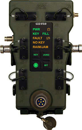
GPS Source has received an indefinite-delivery/indefinite-quantity, firm-fixed-price contract with a maximum value of $16,613,430 for the procurement of defense advanced global positioning system receiver distributed devices (D3). The Army Contracting Command, Aberdeen Proving Ground, Md., was the contracting activity (W15P7T-13-D-C116).
GLI-FLO was developed by the defense contract engineering firm, GPS Source. GLI-FLO is a DAGR Distributed Device (D3) that can replace the position, navigation and timing (PNT) role currently required of the DAGR or other GB-GRAM devices inside a fixed vehicle platform. Designed as a single, secure access point to multiple devices requiring PNT data on a fixed vehicle platform, it saves space, weight and power (SWaP).
“The GLI-FLO contract award is an important milestone in GPS Source’s initiative for the defense market,” said Robert Horton, CEO of GPS Source. “Getting this award was a complicated process, but it helps fulfill our vision of continual innovation in GNSS Signal Availability, especially for the warfighter. We look forward to continuing to provide manufacturing and engineering support services to the Department of Defense.”
Handheld Group has announced the launch of the new version of its popular Algiz 7 rugged tablet computer. The updated Algiz 7 is considerably faster than its predecessor, with better storage capacity, improved security and quicker communication capabilities.
According to the announcement, the ultra-rugged Algiz 7 tablet PC is small, light and fast, with multiple connectivity options and a wide range of functions, ideal for field workers demanding a super-durable product that is tough and powerful, yet light and easy to work with. The Algiz 7 meets stringent MIL-STD-810G military standards for withstanding humidity, vibrations, drops and extreme temperatures, and with its IP65 rating it keeps dust and water out as well.
The new Algiz 7, which started shipping this week, features the following improvements from earlier versions:
A fast and powerful N2600 1.6 GHz Dual-Core Intel ATOM processor.
More memory, with 4 GB of DDR3 RAM.
Better storage, with a 128GB SSD SATA II with recovery partition.
Two full mPCIe slots for improved flexibility.
Ethernet 10/100/1000 (Gigabit).
Added data security with TPM chipset board (chip 1.2).
An updated version of the wireless Gobi 3000 technology for higher communications speed.
A 5-megapixel camera.
Antenna diversity (two antennas) for improved coverage.
“We’ve made significant improvements to the new Algiz 7,” said Jerker Hellström, CEO of Handheld Group. “Better storage, a much faster processor, improved security, a better camera and better communications are some enhancements – and we’ve kept the price point the same as for the previous version of the Algiz 7. This product should remain the tablet of choice for anyone looking for portable, professional field performance.”
The Algiz 7 weighs 1.1 kilograms and has a 7-inch widescreen touch display that features the new and unique MaxView technology, providing brightness in outdoor conditions — even direct sunlight. It runs the state-of-the-art Microsoft Windows 7 Ultimate operating system. GPS navigation functionality is fully built in.
The Algiz 7 is specifically developed for use in tough environments in industries such as mining, geomatics, logistics, forestry, public transportation, construction, utilities, maintenance, military and security.
Abstract submissions are now being accepted for the Institute of Navigation (ION) 2014 Joint Navigation Conference (JNC) to be held June 16-19, 2014.
For Official Use Only (FOUO) U.S.-only sessions will be held June 16-18 at the Renaissance Orlando at SeaWorld, Orlando, Florida; and the 4-EYES CLASSIFIED sessions will be held June 19 at Shades of Green Walt Disney World.
The conference, sponsored by the ION’s Military Division, is the largest U.S. military positioning, navigation and timing conference of the year with joint service and government participation. The event will focus on technical advances in guidance, navigation, and control (GN&C) with emphasis on joint development, test and support of affordable GN&C systems, logistics and integration.
The 2013 Joint Navigation Conference was canceled, so this will be the first time the conference has been held in two years.
From an operational perspective, the conference will also focus on advances in battlefield applications of GPS; critical strengths or weaknesses of fielded navigation devices; warfighter PNT requirements and solutions; and navigation warfare.
The ION JNC features more than 200 operational presentations on a diverse array of topics including:
Advanced Security Technologies/SAASM
Alternate Navigation Technologies: I, II & III
Atomic Clocks and Timing Applications
Autonomous Navigation
Aviation Applications
Battlefield Smart Phone Applications
Celestial Navigation and Star-Tracker Technology
Collaborative Navigation Techniques
GPS Constellation Performance
GPS in Military Applications/NAVWAR
GPS Modernization
Land Applications
Marine Applications
MEMS Inertial Measurement Unit
Micro Navigation Applications
Military GPS Receivers and Military GPS Receiver Technology
Military GPS Use and Experiences
Military GPS/Antenna Technologies and Interference Mitigation
Missile Applications
Modeling and Simulation
Multi-GNSS Receivers for Military Applications
Multi-Sensor Solutions for Guidance, Navigation, and Control
Navigating in Challenged Environments (e.g. Urban, Indoor and
Sub-Surface Navigation)
Precision Azimuth Sensing
Precision Navigation Capabilities for Test and Training
Technical Exhibit and Operational Product Demonstrations. JNC also features a technical exhibit and showcase of Guidance, Navigation and Control technology products and services and Operational Product Demonstrations. For more information on exhibiting and product demonstrations at the ION Joint Navigation Conference, call ION at 703-366-2723 or go to www.ion.org/jnc.
Attendance Restricted. FOUO U.S. ONLY. JNC conference attendance (June 16-19) will be controlled by the Joint Navigation Warfare Center and will be restricted to U.S. ONLY. The classified sessions will have 4-Eyes access (June 19) for citizens of U.S.A., Australia, Canada, and the United Kingdom. All participants must establish a need to know and be approved by the Joint Navigation Warfare Center security office.
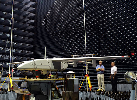
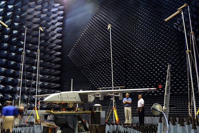
The Navy’s Communications and GPS Navigation Program Office (PMW/A 170) mounted a Small Antenna System on an Aerostar unmanned aircraft then placed it in a room lined with signal-absorbent material, where it was subjected to GPS jamming signals at Naval Air Station Patuxent River, Md. Part of an initiative to protect GPS technologies on small unmanned aerial vehicles, the Navy conducted the tests in July to demonstrate how miniaturized GPS protection devices can prevent interruption of the mission-critical global positioning data. (U.S. Navy photo)
Part of an initiative to protect GPS technologies on small unmanned aerial vehicles (UAV), the Navy recently conducted tests to demonstrate how miniaturized GPS protection devices can prevent interruption of this mission-critical global positioning data.
From July 10 to 24, the Communications and GPS Navigation Program Office, headquartered in San Diego, mounted a Small Antenna System (SAS) on an Aerostar unmanned aircraft, then placed the small UAV in a room lined with signal-absorbent material at the FARM (Facilities for Antenna and RCS Measurements), where it was subjected to GPS jamming signals.
Equipped with model jammers, the FARM facility was used as a stage for the “enemy” to jam the GPS signal and try to knock the UAV off course, said Eric Stevens, the Unmanned Aircraft Systems Communications and Navigation lead for PMW/A-170, which supplied the antenna system. Knocked off course, the UAV would not be able to relay critical intelligence back to the ground control station — disrupting communications among U.S. and allied forces’ ships, aircraft and submarines. In a worst-case scenario, GPS jamming could even cause UAVs to crash.
“If an enemy is trying to jam, or interfere, with the GPS frequency, this antenna allows us to be able to track and acquire the true GPS satellites even in the midst of this jamming and interference,” Stevens said. “What we are doing is demonstrating and quantifying the value of this antenna on small UAVs.”
Personnel involved in the testing were optimistic about the results.
“We are hoping to gain some ground and show there are smaller GPS protection solutions out there,” said Michelle Jackson, an electronics engineer with experience in testing SAS systems on other platforms.
Equipped with the SAS, the Aerostar will be also used to support a U.S. Army pre-deployment war-game scenario conducted at Fort Polk, La., in August, said Donn Rushing, the project lead for MUDO. Rushing participated in the Fort Polk exercises last year and said the addition of the GPS anti-jamming antenna will give the “good guys” an edge this year.
“This new anti-jam system decreases the footprint normally required of such a system, which is now ideal for UAV incorporation and service,” Rushing said. “What makes us smarter is knowing our enemies are smart and that we have to stay one step ahead of them. The SAS development is the latest GPS anti-jam capability to aid the war fighter in combating the bad guys.”
Painting of Colonel Francis Xavier Kane (courtesy of the USAF Space and Missile Pioneers).
Plus: The First Installment of ‘What Is Don Reading?’
This month I planned to catch up on all those important topics that need to be written about but don’t make the cut, mainly due to space limitations — and then came the sad news of the passing of a good friend, mentor, and great Space and Missile Pioneer, Colonel Francis Xavier Kane, Ph.D., USAF Retired, born on December 12, 1918, in Philadelphia, Pennsylvania. To put this date in perspective, consider that the first successful Wright Brothers flight at Kitty Hawk occurred in 1903.
Known simply as “Duke” to his friends and colleagues, he went to be with the Lord on July 18, 2013. He was 94 years old, and the majority of those years were filled with futuristic thoughts and writings about what we could achieve in the heavens above us, and accomplishments that support the Space Age we all live in today.
I first met Colonel Kane in 1973, a full three years after he retired with 27 years of active duty in the USAF. Duke graduated from the U.S. Military Academy at West Point in 1943 in the middle of WWII. In those days, there was not an U.S. Air Force Academy. What would become the U.S. Air Force was then known as the Army Air Corp. The USAF did not become a separate military service until September 18, 1947, with the implementation of the eponymous National Security Act. Still, Duke found himself in an Air Force uniform, flying airplanes and instructing others how to fly. He loved flying, but as you will soon discover, he was an engineer and professor at heart. He played to his strengths.
I never knew Duke while he was in uniform. Despite my best efforts to refer to him with proper military courtesy as Colonel Kane, he quickly remonstrated me and informed me that to his friends and colleagues he was known simply as Duke, and so “simply Duke” it has been for the last 40 years. At the end of our conversation about appropriate appellations, he added, “And no one calls me Francis-Xavier except my wife Virginia, and then I know I’m in the dog house!” (Ed: Duke and Virginia were married for 67 years).
Duke Kane was the first to send me a wonderful handwritten letter of congratulations via snail mail back in 2007, when I penned my first column as the Defense Editor for GPS World magazine. The letter was extremely complimentary, with high praise I had certainly not yet earned, but then that was Duke — always supportive. Comments in his letter I will always treasure are “Finally, we have someone writing regularly about GPS that actually knows what he is writing about…and don’t forget, Don, I have declassified history files dating back to the early days of the 621B program and they are always at your disposal.”
I heard regularly from Duke, several times a year at least, and it was always a note of encouragement or praise; what every journalist needs. It meant a lot to me personally that it came from Duke because, you see, Duke was a very prolific writer and thinker himself, and perhaps at times even a frustrated journalist. Some of his wonderful and insightful writing on the possible uses of the “Space Domain” as a medium for our future infrastructure are seminal and even legendary today — such as the one he wrote on terrestrial navigation using space assets, which helped spawn the aforementioned 621B program that led to the Global Positioning System. More on that later.
Duke was a prolific writer, but rarely took credit for his futuristic ideas. While serving as an Air Force planner, Duke penned papers concerning the initial development and importance of systems analysis and applications of early computers for both terrestrial and space applications. Early on, Duke saw the need to develop a coherent planning and policy environment in the DoD (Department of Defense) to enhance the evolution of and to formally inculcate the U.S. space program, to include systems and technology planning.
In the early 1960s, Duke wrote profusely concerning space-based missile warning, known today as the DSP or Defense Support Program and more recently as the SBIRS or Space-Based Infrared System. He wrote about manned space maneuvering vehicles, now known as the Space Shuttle, which came and went during his lifetime, as well as the detection and tracking of mobile missiles and the possibility of shooting them down with lasers. He also wrote about lasers as “blindingly effective” anti-satellite weapons, a capability and problem that modern planners and operators are still worrying about and dealing with today. He wrote about advanced ballistic missiles, which we know today as the MX or the Peacekeeper program.
He was always ahead of his time. He wrote knowledgeably about space-based missile defense, a theme he would later revive as a member of the GPS Independent Review Team (GPS-IRT), which several of us invited him to join because in the 1960s he penned significant white papers concerning the possibility and credibility of navigation satellites, which of course we know today as the Global Positioning System. He was, in many respects, a visionary.
Before his retirement in 1970, Duke managed to find the time to complete a master’s degree in political science and a doctorate from Georgetown University. He went on to teach courses at UCLA, the University of California at Los Angeles, the Catholic University of America, and Pepperdine College.
Duke loved to think and write about the future. One of his favorite topics was the Global Positioning System, which in many respects sprang from the classified 621B program he supported toward the end of his Air Force career.
Aerospace Corporation Historian Steven R. Strom, in his insightful writings and interviews with luminaries of the early U.S. space programs, with an emphasis on the history of GPS, wrote that in 1963 the Air Force Space Systems Division funded Colonel Kane to lead a classified project known as 621B. Phase one of 621B featured the engineering concept for a “space-based navigation system,” later to become known as the Global Positioning System or more formally as the GPS/NAVSTAR. According to Colonel Bradford Parkinson, Ph.D. USAF, retired — and the first GPS Program Manager/Director at what is now SMC — Project 621B had “many of the attributes that you now see in GPS. It has probably never been given its due credit.”
Duke never forgot those early days or got over his involvement and fascination with GPS. In 1993, 23 years after his retirement from active duty, Duke founded the GPS International Association. He served on the U.S. Department of Transportation Civil GPS Service Interface Committee and authored more than 20 significant articles on GPS and other critical space-based systems.
Finally, in 2010 Duke was inducted as an Air Force Space and Missile Pioneer — his picture and a short biography hang in the entryway of AFSPC (Air Force Space Command) Headquarters (the Hartinger building) on Peterson Air Force Base in Colorado Springs, Colorado — a well-deserved honor of which Duke was extremely but humbly proud.
Colonel Francis Xavier “Duke” Kane — fighter pilot, flight instructor, engineer, professor, visionary and, for many, a friend and mentor who will be sorely missed.
Now on to the Catch-up Topics…
As my regular readers are aware, I generally take a long time to evaluate PNT and PNT-related equipment sent for me to review, and I only review about one in twenty items. For years I have reviewed and recommended OtterBox equipment for keeping iPads, iPhones and assorted PNT handhelds safe from the environment. They are indeed some of the best add-on “ruggedizers” I have ever encountered. However, a few weeks ago I called the wonderful folks at OtterBox to enquire about a rugged mounting system for PNT equipment and discovered to my dismay that they just don’t do that. Not an area of expertise for them. Fair enough, and I certainly appreciated their honesty. Then, out of the blue, I received an email from Francesca Marino at Blast Media on behalf of Rokform, a relatively new U.S. company that builds rugged mounting systems that she said were perfect for our warfighters. She even included the following advertisement/vignette:
Made in the USA, all Rokform products are designed and engineered of CNC aircraft grade aluminum. Each accessory allows soldiers to mount their phone magnetically, or by Remote Mounting System (RMS), to dashboards of any vehicle. A member of the Navy inland search and rescue team accounts his experience with Rokform’s RokBed v3 case while on duty for helicopter rappel operations:
“I’m active duty military, and one of our engineers bought the magnet for his [Rokform] case as I had. While standing on the quarterdeck, he accidentally dropped his phone and tried to kick it back onboard before it went in the drink. He only succeeded in kicking it overboard…only to have it catch itself on the side of the ship! Several others saw what happened and were surprised when he was able to retrieve his phone from its watery grave! I had to share that story as you had to be there to believe it.”
Francesca asked if I would be interested in receiving a sample of a Rokform rugged smartphone or iPad case for testing.
I took Francesca up on her offer, and frankly, I am impressed with the earth-magnet mounting system on the Rokform equipment cases, and especially with the v3 mounting system (see picture). I have used the v3 for a couple of months in numerous rental cars and with both my iPhone and my iPad — it works flawlessly. It has never released involuntarily even on hot and cold surfaces, and it has never dropped my iPhone or iPad on the dash. Not something I can honestly say about any other device of this type I have tested. I also use the v3 at home on a granite counter top Sometimes just getting it unstuck is a chore, but a happy one. It simply works as advertised; it holds whatever you attach securely and effectively, and has the flexibility and maneuverability to do so in all kinds of environments. It is truly rugged, versatile and very useful. It stays where you mount it, and it is made in the USA. I highly recommend it.
The Rokform v3 mounting system.
Specifications:
There are numerous hands-free options for the v3 Suction Mount. Attach the mount to any smooth, flat, non-porous surface, and adjust to your ideal viewing angle. A few of the locations I tested include a conference table, desk, car window, windscreen, mirror, and sunroof.
Features
Polycarbonate and die cast zinc construction
360-degree turn and rotation
210-degree tilt for ideal viewing angles
Powerful suction pad measures 3.4 inches (86.4 mm) in diameter
The v3 is compatible with all v3 mountable phone cases, which pretty much covers the waterfront on phone cases, and so they should have one that fits your needs.
There is a separate attachment for your mobile devices that uses adhesive if you just don’t want to use the suction cup model — just beware that once you attach the separate small earth-magnet device, to a case or your automobile, it is not coming off. Be sure you want it there permanently. I view this as a good thing: no falling iPhone or iPads. But it is just something you need to contemplate. Of course, the v3 works with a tenacious suction cup, so there is not a permanence issue with that device. Try it.
What Is Don Reading?
Ever since I started penning this column and mentioning books I have read or am reading and frequently quoting from them, I have received a steady array of requests to discuss the books and recommend or review them, even if they are not primarily about GPS or PNT.
Certainly, locating books to review is not an issue. My wife calls me a parallel reader, in that I am generally reading two, three, even four books at a time. The question is will any of them be of interest to you? Let’s find out. While we are not sure this feature will appeal to all of you, or if we can make this a regular feature due to time and space limitations, we will give it a trial run this month. Please let us know what you think and what you are reading that may be of interest to our readers, at [email protected].
I recently had the pleasure of reading two books about wartime that cover two distinct periods of time and are actually in different genres. However both books are fascinating for very different reasons.
Viper Pilot: A Memoir of Air Combat, by Dan Hampton (USAF, Ret).
This book is a “must-read” for air combat aficionados in that it is a seat-of-the-pants warfighter, fighter-pilot view of the air wars in Iraq, Afghanistan, and Kosovo. It is also a very candid fighter pilot’s view of how those wars were managed or not managed, as the case may be. Dan certainly pulls no punches, and if you have any romantic visions of aerial combat and how it comes about — as portrayed in movies like Twelve O’Clock High — then this book may prove to be an eye-opener.
Be warned, it takes a chapter or two for Dan to set the hook, but if you are still engaged by chapter three, you should be good and firmly on the line. The first two chapters are more of what those of us in-the-business refer to as standard fighter-pilot rhetoric, as in “I am god’s gift to the world and am without a doubt the world’s best fighter pilot.” Indeed, the first two chapters do a good job of substantiating the old barb, “You can always tell a fighter pilot, but you can’t tell him much.” Today, to be politically correct, I guess that would have to be him or her much.
However, in retrospect, who would want to read a book by a warfighter, especially an F16C Wild Weasel fighter pilot, who was not absolutely sure of his or her superiority? Not me. Indeed, another old barb that applies here, “There are bold pilots and old pilots but very few old bold pilots.” After you read Viper Pilot, I think you will agree than Dan Hampton, who by his own humble admission is one of the most decorated F-16 pilots in American history, is certainly the exception to the rule.
Most importantly, Dan Hampton gets it right, technically and operationally. His frustration with incompetent ground-pounders and support personnel notwithstanding, he tells it like it is, and you quickly detect that his frustrations are probably justified and his feelings, which he freely shares without compunction, are certainly justified, at least in his view of the world.
As far as I can decipher, and I was in that business for almost thirty years, there are no glaring errors or even small mistakes about procedure, process, or organizational charts. He tells it like it is and lets the pieces, whether blame or commendation, fall where they may. It is a great read, and one that all history, war, airplane and aerial-combat buffs will find a must read. And yes, there are numerous references to GPS and GPS-guided weapons and effects. I thoroughly enjoyed it — even though the language can at times be a bit over the top and is totally unnecessary to the storyline, but then, when you are God’s gift to fighter pilots, what do you expect?
By the way, rumor has it Dan is in the process of writing another book. I, for one, can’t wait.
The Ledger, by Lloyd Holm
This wartime romantic novel by Lloyd Holm is certainly a departure from Viper Pilot. This book is romantic in nature, but in a good way, and yet is also a very true and authentic synopsis of what it was like during both WWI and WWII, which was globally known as the “War to end all Wars.”
Lloyd Holm does a great job of setting the hook immediately. No waiting. I read it in one sitting and was disappointed only because it was over. I wanted the story to go on and on. Hint to Mr. Holm: There is certainly a sequel here if you have it in you.
This fast paced riveting story concerns two families and their involvement with each other during both world wars. The story more or less begins with a very authentic and well-documented event, the 1914 lull in fighting due to the spontaneous and unofficial 24th of December Christmas Truce during WWI. Both Allied and German soldiers meet in “No Man’s Land” between the trenches to exchange food, stories and camaraderie. During this incredible event, the lives of two families, German and Jew, become irrevocably intertwined — the rest, as we say, is history and the storyline of The Ledger.
This wonderful book is authentic and detail oriented. I could find no fault with the well-documented history, the unit designations, or the language, as English, French, and German words are used liberally and in the correct context.
Whether you read this book as an historian, a romantic, or a war buff, you will find it satisfying on all accounts, and I dare you to put it down once you start. Sequel?
Until next time, read a good book and happy navigating.
VectorNav Technologies, a provider of inertial navigation solutions for the industrial and military markets, announced Tuesday that it will supply its VN-200 GPS-aided inertial navigation system (GPS/INS) for use in Troll Systems’ SkyLink MINI II directional antennas. The next-generation version of the SkyLink antenna provides Troll Systems’ customers with a lower-cost and easier to integrate update to its existing SkyLink antenna solution, the company said.
VectorNav made the announcement at AUVSI’s Unmanned Systems North America 2013 Conference, August 12-15, in Washington, D.C., where both companies are exhibiting.
About the size of a postage stamp, VectorNav’s VN-200 is a calibrated MEMS-based GPS/INS that provides a coupled position, velocity, and attitude solution suitable for a wide range of static and dynamic operating conditions. The VN-200 incorporates an onboard high sensitivity 50-channel u-blox GPS module. The microprocessor runs an aerospace-grade Kalman filter algorithm at a rate of up to 200 hertz and provides accuracies better than 0.25 degrees in pitch and roll and 0.75 degrees in heading. The upgraded version of Troll Systems’ SkyLink MINI II antenna features a deeply embedded, surface mount VN-200 GPS/INS module that delivers control and stabilization for the gimbaled antenna system.
The only airborne directional antennas to pass DO-160 testing, Troll Systems’ SkyLink antennas are compact, lightweight and steerable airborne tracking antennas that equip its users with an industry leading air-to-ground data-link solution. The upgraded SkyLink antenna system featuring the VN-200 GPS/INS enables Troll’s customers to eliminate the need for external hardware or GPS input, reducing the cost of installation and the need to certify or calibrate external positioning devices.
The performance of the VN-200 GPS/INS enabled the upgraded antenna system to maintain the high degree of accuracy required to replace the existing SkyLink navigation system, which was comprised of a Quartz MEMS-based attitude heading reference system (AHRS) and high-end GPS receiver, VectorNav said. Several rounds of ground and air testing and qualification with engineers from both teams demonstrated the capacity of the miniature MEMS-based GPS/INS solution to provide high performance in high dynamic conditions and when subjected to high-frequency vibration. VectorNav worked closely with Troll Systems to implement several features to add to the robustness of the solution, including an embedded magnetic hard and soft iron calibration routine and dynamic start-up routine.
“We are very pleased to be working with Troll Systems on their SkyLink line of antennas, which represent the gold standard for directional antennas in the industry,” said John Brashear, VectorNav’s President. “We are also proud to demonstrate the capacity of our VN-200 GPS/INS to provide a solution comparable to much higher-end systems and for an application that has very demanding and sophisticated navigation and control requirements.”
U.K. firm Chronos Technology has released the CTL3520 handheld GPS Jamming Detector and Locator System. Aimed specifically at detecting GPS jammers hidden in vehicles, the unit can pinpoint even the weakest jammer and identify the vehicle in which the jammer is hidden, even in a busy multi-storey car park, Chronos said. Other applications include detecting vehicles with jammers at ports, fleet depots, airport car parks and taxi ranks.
The CTL3520 device was recently tested by representatives of law enforcement and security agencies in screened rooms at the MIRA test facility in Warwickshire and successfully identified hidden jammers both in vehicles and people’s pockets.
The CTL3520 was developed from research undertaken by the University of Bath and is a significant commercial outcome of the Sentinel research project, which was partly funded by the Technology Strategy Board.
“Previous jamming detecting products have been unable to identify which vehicle is hosting the jammer,” said Charles Curry, founder and managing director of Chronos Technology Ltd. “This has been a particular limitation and a major challenge for people wishing to protect critical infrastructure if faced with GPS jamming emanating from a nearby vehicle. Most websites currently selling GPS jammers maintain that the operating distance of a jammer is just a few meters. This is simply not true. We have tested GPS jammers in controlled trials and their range is easily 250/300 meters which makes specific vehicle identification extremely difficult, particularly in a multi-storey car park. The CTL3520 solves this problem and can pick out one vehicle in a thousand which has the jammer installed.”
“This product contains advanced technology which is the culmination of more than two-years of research and development at the University of Bath, funded by the Engineering and Physical Sciences Research Council (EPSRC) within the Sentinel project. We are delighted that our collaboration with Chronos has led to a commercial product,” said Robert Watson, University of Bath Electronic & Electrical Engineering Department.
In addition to UK users, Chronos is seeking international resellers and distributors to take the product into critical infrastructure protection and law enforcement markets where there is a recogniszd concern about the proliferation of low cost GPS jammers used by criminals to cover their tracks or vehicle drivers for personal privacy purposes.