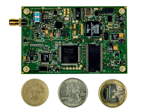
On August 30, QinetiQ and Rockwell Collins demonstrated the first joint satellite navigation positioning using live signals from the encrypted governmental services from the U.S. Department of Defense (DOD) GPS Precise Positioning Service (GPS-PPS) and the new European Galileo Public Regulated Service (PRS). The signals on GPS L1 and L2, together with Galileo PRS L1A and E6A, were processed and combined to form multi-frequency, multi-constellation position fixes.
Positioning, navigation and timing (PNT) services provided by GNSS, such as GPS and the forthcoming Galileo system, are essential to underpinning both commercial and economic activity (the EC estimates 6-7% of the developed world’s GDP) and the delivery of governmental responsibilities including the safety and security of citizens.
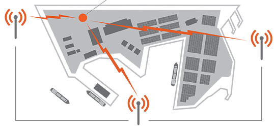
GNSS systems such as GPS and Galileo make use of very low power signals and are subject to inadvertent interference, deliberate jamming and spoofing (where an attacker generates a false signal masquerading as a valid one to mislead a user receiver). Attacks on GNSS may range from low-level criminal nuisance (a delivery driver stopping their employer tracking them), enabling theft of high-value vehicles fitted with trackers, through to state-sponsored attacks. This is potentially a significant concern for a wide range of governmental users including law enforcement, security and emergency services, critical national infrastructure, transport and defense users. The use of multiple independent, secured navigation services provides significant improvements to navigation robustness and, along with other measures, offers substantial counters to these threats.
“This has been our first opportunity to explore how secured navigation services on GPS and Galileo can be used together to provide users with critical reliance on PNT with robust and continuous navigation services,” Nigel Davies, Head of QinetiQ’s Secured Navigation Group said. “QinetiQ is proud to be a key, long-term contributor to the Galileo Programme, having been working closely with the European Space Agency (ESA), the European GNSS Agency (GSA), European industrial partners and European Member States since 2003. QinetiQ and Rockwell Collins wish to thank ESA, the EC and GSA for support in accessing Galileo, as well as the UK Space Agency, UK Satellite Applications Catapult and the UK MOD for their support.”
Northrop Grumman Corporation is applying a modular, open architecture approach throughout its product portfolio, allowing for rapid addition of new avionics capabilities for warfighters. Northrop Grumman is already applying the FACE Reference Architecture and interfaces to existing programs and products, including an embedded GPS/inertial navigation system for the Joint Precision Approach and Landing System and a highly adaptable mission equipment package.
Northrop Grumman will leverage the corporation’s expertise in open architecture to implement FACE requirements for both current and future programs, including the Black Hawk H-60L Digital Performance Plan program and Tech-Refresh Mission Computers for the H-1 Upgrade program.
The company plans to participate in demonstrations that will promote maturation of the FACE Reference Architecture by enabling companies to deploy their products in a functional, standardized FACE software environment.
Also, the company’s Transport Services Segment aligns with the FACE Technical Standard requirements and provides a standard interface that allows portable avionics applications to be integrated with a variety of architectures and aviation platforms.
“An open architecture approach is critical to the affordability, innovation and effectiveness of avionics systems,” said Ike Song, vice president of Northrop Grumman’s Situational Awareness Systems business unit. “We are using performance-proven solutions from across our corporation to offer highly flexible, affordable products that support reuse on various platforms.”
Northrop Grumman’s Common Mission Management System (CMMS) establishes a common foundation for affordable control systems to support a variety of the company’s unmanned products. Based upon open architecture standards and standard off-the-shelf commercial hardware and software infrastructures, the Northrop Grumman CMMS product line avoids the need for dedicated, custom-built command and control systems for individual platforms. Also, the Northrop Grumman CMMS product line enables pilots to operate a variety of dissimilar unmanned platforms using the same informational displays and control features, thereby improving mission effectiveness while reducing training requirements.
With its expertise in unmanned aerial systems (UAS), the Northrop Grumman team was instrumental in leading the FACE Consortium’s effort to align with the UAS Control Segment (UCS) information model, establishing a common conceptual data model and metamodel as a framework that defines rules and conventions for developing interoperable software components for unmanned aerial system ground control stations. Further collaboration under the UCS/FACE Memorandum of Agreement is anticipated in aligning the FACE and UCS standards.
Northrop Grumman is a leading global security company providing innovative systems, products and solutions in unmanned systems, cyber, C4ISR, and logistics and modernization to government and commercial customers worldwide.
Northrop Grumman Corporation has developed and demonstrated a new micro-Nuclear Magnetic Resonance Gyro (micro-NMRG) prototype for the Defense Advanced Research Projects Agency (DARPA), providing precision navigation for size- and power-constrained applications.
The development of a hermetically sealed micro-NMRG that meets precision navigation requirements along with a successful prototype demonstration marks the fourth and final phase of DARPA’s Navigation-Grade Integrated Micro Gyroscopes (NGIMG) program. The culmination of the eight-year program is a micro-NMRG that offers near navigation-grade performance for the next generation of high-precision inertial sensors.
Northrop Grumman’s micro-NMRG technology uses the spin of atomic nuclei to detect and measure rotation, providing comparable performance to a navigation-grade fiber-optic gyro in a small, lightweight, low-power package. Additionally, the gyro has no moving parts and is not inherently sensitive to vibration and acceleration. The technology can be used in any application requiring small size and low power precision navigation, including personal and unmanned vehicle navigation in GPS-denied or GPS-challenged locations.
“Our miniature gyro technology offers unprecedented size, weight and power savings in a compact package, exceeding program requirements,” said Charles Volk, vice president of Northrop Grumman’s Advanced Navigation Systems business unit. “This important technology can help protect our warfighters by offering highly accurate positioning information, regardless of GPS availability.”
The NGIMG effort is part of DARPA’s Micro-Technology for Positioning, Navigation and Timing program that aims to develop technology for self-contained, chip-scale inertial navigation and precision guidance. Northrop Grumman began the first phase of the NGIMG effort in October 2005 and has consistently met or exceeded the performance goals of each program phase.
The scheduled October 23 launch of GPS IIF-5, the fifth in the current “follow-on” generation of GPS satellites, has been postponed in order to complete a review of an adjustment made to the rocket’s upper stage engine. A fuel leak in that engine of the Delta 4 rocket during a GPS launch in October of last year created some worries for the Air Force and the United Launch Alliance (ULA), although the satellite successfully reached its intended orbit despite the upper stage producing less thrust than expected.
A subsequent investigation determined a fuel leak in the engine system was responsible. Two medium Delta IV rockets and one heavy version have launched since then, but ULA said continued investigation had produced new information about the engine’s first start.
While no new definitive launch date has been set, the ULA released a statement:
“The ongoing Phase II investigation has included extremely detailed characterization and reconstructions of the instrumentation signatures obtained from the October 2012 launch and these have recently resulted in some updated conclusions related to dynamic responses that occurred on the engine system during the first engine start event.
“The GPS IIF-5 Delta IV launch is being delayed to allow the technical team time to further assess these updated conclusions and assess the improvements already implemented and determine whether additional changes are required prior to the next Delta IV launch.
“The Delta IV booster for the GPS IIF-5 mission has completed the standard processing and checkout on the launch pad and will be maintained in a ready state for spacecraft mate and launch pending completion of this assessment. A new launch date will be established when the assessment of the updated dynamic response information is completed in the coming weeks.”
To fly a UAV in the U.S., you’d better be able to avoid any other aircraft — and ADS-B is one component of that capability. When the FAA and agencies around the world get their UAV regulations aligned with those levied on passenger-carrying aircraft, GNSS receivers on board UAVs will likely need to be qualified to equivalent standards. One company is already there.
When I was wandering around the show floor at the Association of Unmanned Vehicle Systems International (AUVSI) in Washington, D.C., in August, I got a pleasant surprise when I bumped into an old friend I knew from Calgary. Jayanta Ray was a grad student at the University of Calgary (U of C) when I was at NovAtel a few years ago. The students of the GNSS courses at U of C were often at local Calgary ION chapter meetings I organized or attended; there were also a few joint industry-university projects, and there were many, many discussions. So meeting Jayanta (Jay) at the Accord Systems/NexNav booth was a pleasant surprise, and it was good to renew our acquaintance.
This got me thinking that maybe some of that U of C receiver magic had somehow found its way through Jay into the airborne qualified receivers that Accord Technology is offering for UAVs. Jay is actually a member of the GPS World Advisory Board, and provides a great overview of what’s good and what’s different about airborne qualified receivers in this month’s issue of GPS World.
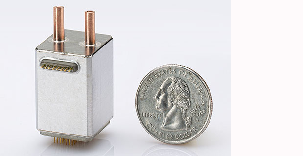
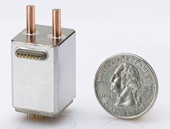
NexNav mini is also qualified for airborne GPS and ADS-B use.NexNav mini is also qualified for airborne GPS and ADS-B use.
Accord Technology is based in Phoenix, Arizona, and is the U.S. arm of Accord Software and Systems of Bangalore India, specializing in FAA-certified airborne versions of Accord’s GPS receivers.
At AUVSI, one of the hot topics was “Sense and Avoid” — if you are to fly a UAV in the U.S. National Airspace System (NAS), you’d better be able to avoid any other aircraft, and maybe also be able to tell other aircraft in the NAS where you are. ADS-B (Automatic Dependent Surveillance-Broadcast) is one component of that capability. ADS-B uses a network of ground stations that relay ADS-B transmissions from aircraft (called ADS-B Out) in the NAS to the Federal Aviation Administration (FAA) air-traffic management system, and the signal is also available to aircraft flying in the system if they are equipped to listen to the message (ADS-B In). Air Traffic Control (ATC) can then verify that you are where you are supposed to be, and your actual position shows up more readily on their tracking systems. Right now, ATC makes extensive use of radar tracking and aircraft transponder signals to track aircraft — ADS-B will be more efficient, less costly to maintain, and is capable of aircraft-to-aircraft position reporting. By 2020, it will be mandatory if flying within the U.S. NAS.
The other part of this story is that, eventually, when the FAA and other agencies around the world get their UAV certification regulations aligned with those levied on passenger-carrying aircraft, GNSS receivers on board UAVs will likely need to be qualified to equivalent airborne standards.
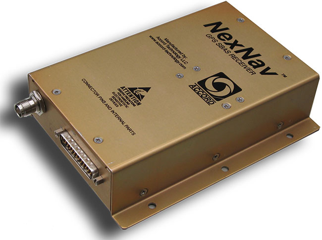
Accord has already done an enormous amount of work to qualify its NexNav receivers for both requirements, and was at the AUVSI conference to let the UAV community know that these receivers are available now. If you were developing a new UAV now, with a view to selling lots into the anticipated wide range of commercial applications, its certainly going to help your case with the certification authorities to install as much off-the-shelf certified avionics as you can. Accord already sells these receivers to a number of general aviation system manufacturers, and also supplies stand-alone ‘TSO’ed” receivers in enclosures for use on a number of aircraft types. When an airborne receiver is granted the TSO (Technical Standard Order) designation by the FAA, it recognizes that the receiver has been designed, built and qualified to stringent airborne technical requirements and is authorized by FAA for use on aircraft.
So how does a company with its HQ in India get to hold an FAA TSO for a GPS receiver? Well, other than taking years to develop the receiver in accordance with approved development standards, document the hardware and software design, and conduct test and verification activities, the company also proves to the FAA that the receiver meets the FAA-specified airborne GPS functional requirements. Loads of engineering work — and then you have to convince FAA that you did it all and did it right.
Accord in Bangalore actually teamed up with AvValues in Phoenix to form a joint venture known as Accord Technology (AT) to work the project together. Most of the original receiver development work was done in Bangalore, while AT in Phoenix became responsible as the design authority, and for production, certification activities, customer service, product support, and business development. Naturally, Accord in India still does ongoing engineering support and supplies receiver cards to AT under contract. The other twist to the story is that final assembly and test is carried out at the AT facility in Anchorage, Alaska, where the TSO was approved by the local FAA office.
But Accord isn’t only into airborne receivers. The company has been around since 1991 and has significant engineering resources (around 400 electronic and computer engineers) — with more than 700 man-years of GNSS R&D and production involvement. Here are some examples of the other GNSS products which Accord has in its technology/product inventory:
GPS L1 RF down-converter.
GPS RF & baseband.
GPS module.
GPS Spacecraft Positioning System (SPS).
Time-code generator.
SPS was developed for the Indian Space Research Organization (ISRO) and has been flown on all Indian low-Earth-orbit satellites, including IRS P4/5/6, TES, CartoSat, SRE and OceanSat.
IRNSS Reference Receiver.
The Reference Receiver is fielded in the ground-monitoring network for the Indian Regional Navigation Satellite System (IRNSS), which may mean that the ground network is using at least dual-redundant reference data, as NovAtel has also provided a similar receiver for IRNSS. Accord is also working on IRNSS user receivers.
Other receivers include high-dynamic GPS-GLONASS receivers, GPS/GLONASS/Gagan SBAS receivers, an internal GPS/GLONASS/Gagan simulator, and a handheld GPS/Gagan receiver with integrated three-axis compass and pressure altitude sensor — the latter used by a number of paramilitary forces.
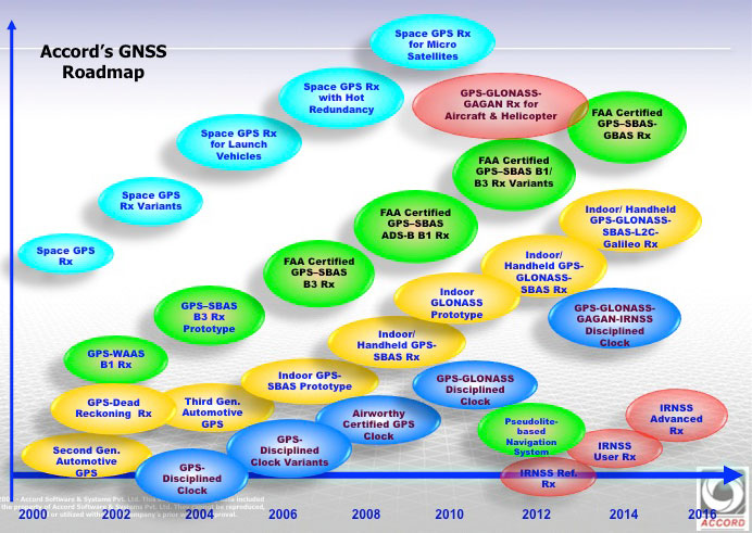
Accord GNSS roamap.
And as can be seen from the Accord GNSS Roadmap, they aren’t done yet!
You might ask yourself, where in the heck did all this come from? Certainly, there is an element of internal support with work for ISRO and Indian forces, but you don’t jump into this without some background. Well, the principle activity for Accord has been and still remains high-integrity software development for avionics systems — this is probably what Accord is known for in Europe and to a certain extent in North America. Its customer list for RTCA DO-178B/C airborne software sounds like a who’s who of aircraft and helicopter manufacturers — including Airbus, Boeing, Mitsubishi, Gulfstream Eurocopter/AugustaWestland/NHIndustries, Sikorsky, and Hindustan Aeronautics Limited (HAL).
Accord’s activities have included complete and partial life-cycle activities — all the way from requirements definition, software design and development, to independent verification and validation. For those of us who’ve worked in this field, we recognize that these are considerable technical capabilities — indeed, more than 50 engineers at Accord have been trained in the art of airborne software development by FAA-qualified engineering representatives. Working in this area and successfully bringing avionics systems through the qualification/certification process, companies either become capable or break all their bones trying! Clearly, Accord has been schooled in systems that are at the forefront of avionics technology, and has passed through the practical fire of qualifying airborne systems successfully.
So, it’s not really surprising that Accord went on to spin off into airborne GNSS receiver development once it gained wide visibility and knowledge of aviation technology and began to look at related markets. And with the Indian government policy of developing indigenous industries, Accord likely had some internal Indian customers. Quite a number of parallels with the way Europe has encouraged its own GNSS industry through the Galileo program.
With several avionics OEM manufacturers already using embedded NexNav TSO certified receivers in their systems using incorporating licensed designs, Accord looks well positioned to continue its airborne market growth. Accord’s success has so far been in general aviation, but it has wider aspirations, which include commercial transport aircraft (airline aircraft) — this is a segment which has the highest level of development/certification scrutiny and is therefore the most expensive segment in which to compete. Let’s hope Accord continues its growth and there is room in an expanding market for these relative newcomers.
Many may consider it a distinction without a difference, but quality matters, whether it concerns a life-changing decision or something as simple as which conference to attend. When resources are scarce, making the right decision, or sometimes just making any decision, matters — for many in our government this paradigm should reign supreme.
Over the past 24 months, it seems there have been more conferences and symposia that depend on government attendees cancelled or postponed than there have been quality events to attend. Politics aside, the U.S. government’s fiscal woes, which include sequestration and the latest partial U.S. government shutdown, are merely endemic of a much greater problem. Decision makers are unable to make decisions, negotiate or even consider compromise, and the last time I checked, decisions, indeed quality decisions, are critical to the success of any endeavor, be it government or business.
More than 2500 years ago, Pythagoras (yes the Pythagorean Theorem mathematician) said “Choices are the hinges of destiny,” and make no mistake about it, the decision to not make a decision or the inability to act is still in the end a decision, just not an action or non-action of which one should be proud. And this inability to make a decision still affects your destiny today or our destiny where Congress is concerned. William James may have been thinking about the U.S. Congress when he said, “When you have to make a choice and don’t make it, that in itself is a choice.” Actually, my secretary summed it up nicely, extolling her frustration with our do-nothing Congress, “…in the end if I conducted myself as your employee the way Congress has conducted their affairs for the last 24 months, I would no longer be in your employ. You would have fired me long ago.”
Fortunately, for the rest of the world, there are people who seem capable of making momentous decisions on a daily basis — imagine that. And despite what the entrenched U.S. Congress doesn’t decide, the world does go on, even as the somnolent U.S. government shuts down and irrationally decides not to allow government employees and the military to attend critical conferences or symposia. Since Congress can’t do anything, it appears they want to mandate that everyone else emulate their indecisiveness. Despite the governmental ennui, there are some bright spots. In the last two months I had the pleasure of attending two separate conferences concerning GIS, GPS, GNSS, and PNT respectively that I highly recommend for your consideration. As I said earlier, quality matters, and both of these conferences have quality in abundance, especially in the areas of planning, presentations, location and attendees.
GeoGathering
As the comfortable, casual name implies, GeoGathering 2013 was more of a gathering than a full-blown mega conference, but then, that is also what sets this event apart. Especially from the National Space Symposium, which also takes place in Colorado Springs at a major resort but which draws more than 10,000 participants.
GeoGathering 2013 managed to gather ~150 GIS participants from around the globe, and in its own way was just as informational as many larger events. The four-star venue was outstanding, as the Cheyenne Mountain Resort has always been a laid-back location with restaurants and ambiance almost second to none. GeoGathering played out comfortably, with little stress, over two days, 21-22 August, during which the Rocky Mountain weather graciously cooperated.
The event was subtitled “GIS for Gathering and Production Lines,” which simply means it was primarily about gathering and using GIS data and meta-data successfully in a business environment. If that sounds a bit dry, in actuality it was a wonderful conference, since the prime ingredient for any successful conference is the people and the venue. Both were outstanding. The networking time between speakers and panels made for a very productive two days. I highly recommend this conference for those interested in anything to do with GIS (geographical information systems). GeoGathering 2015 will be held somewhere in Colorado, and right now you can influence that decision by going to the GeoGathering website and voting on a location. See you there.
ION GNSS 2013
Institute of Navigation Global Navigation Satellite System Symposium
The first question I typically hear when I mention the acronym GNSS in a non-PNT-oriented crowd is “What is GNSS?” GNSS stands for Global Navigation Satellite System(s), and is the standard generic term for satellite navigation systems that provide autonomous geospatial positioning, and sometimes time and frequency data, with global and/or regional coverage. This oft-used term has expanded to include GPS, GLONASS, Galileo, BeiDou and other regional or global PNT systems. And for me, there is no better global technical GNSS event than the annual ION GNSS symposium. For the last two years, with an attendance figure of about 1,000 per year, this seminal event has been held in Nashville, Tennessee. Next year and the following year, ION GNSS moves to Tampa, Florida, the home of our elite military special forces.
If you would like the bottom line up front, several years ago I penned a review of the ION GNSS event and it went something like this: “The ION GNSS Symposium is simply the best international technical symposium on GNSS that exist today, bar none.” Frankly, my opinion has not changed. The GNSS symposium has not changed in quality, even though the U.S. military participation has dwindled significantly due to circumstances detailed earlier in this column, but in many ways the symposium continues to improve.
The venue for the last two years was the Nashville Convention Center in Nashville, Tennessee — or Music City, as those of us in the U.S. know it — and it was a great location. This year, there were also FOUO sessions, which were extremely interesting, but because of the classification, I cannot say much more in this medium. The FOUO sessions were essentially a hold-over from the ION Joint Navigation Conference (JNC) event that was canceled earlier in the year due to the last-minute lack of participation by government participants. However, Lisa Beaty, the executive director for ION, assured me that the JNC 2014 event will take place come h*** or high water.
The new ION Military Division, which is headed by my long-time friend and colleague Jim Doherty (USCG, Ret), a former president of ION, now sponsors the Joint Navigation Conference, which is billed as the largest U.S. military navigation conference with joint service and government participation. The event focuses on technical advances in guidance, navigation, and control (GN&C) with emphasis on joint development, test and support of affordable GN&C systems, logistics and integration.
ION describes the JNC event as a conference that includes technical exhibits that showcase guidance, navigation and control technology products and services as well as operational products and demonstrations. With a decidedly operational perspective, the conference focuses on advances in battlefield applications of GPS, critical strengths or weaknesses of fielded navigation devices, warfighter PNT requirements and solutions, and navigation warfare.
As I mentioned, JNC is the annual ION event that normally features the FOUO U.S.-only presentations. Next year, ION JNC conference attendance June 16-18, 2014, is controlled by the Joint Navigation Warfare Center (JNWC) and is restricted to U.S. citizens only. The classified sessions on June 19, which typically feature a warfighter panel, which I have had the honor to help populate for the last several years, will feature 4-eyes access for citizens of the U.S.A., Australia, Canada and the United Kingdom. All participants must establish a need to know and be approved by the Joint Navigation Warfare Center security office. The 2014 Joint Navigation Conference takes place at the Renaissance Orlando at SeaWord in Orlando, Florida.
But that is JNC next year and I digress, so let’s get back to this years ION GNSS symposium. The amazing feature of this event is that you can literally attend a presentation on any aspect of GPS/PNT that you can name. For example, I wanted to attend specific presentations on: GPS time, PNT frequency stability, PNT atomic reference systems, L2C, L5, AEP, OCX, L1C, M2PS, and M-code, as well as jamming and spoofing mitigations. The problem, of course, is that there are numerous presentations on these topics, and many of them occur simultaneously. You have to carefully plan your time, and I frequently found myself, along with many others, sprinting from presentation to presentation. I did not want to miss anything, and I can truthfully say there are very few conferences where this is the case. The ION Papers Committee does a great job screening the papers and making sure they are relevant.
Plus, one of the best perks of being an official ION member is that, in case you miss a presentation, the symposia papers are all available online at the ION site within just a few days of the event.
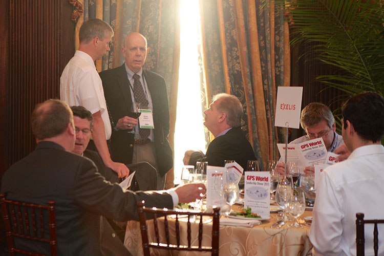
Don Jewell visits the Exelis table at the GPS World Leadership Dinner.
Galas and Awards
The after-hours highlight of the ION GNSS event every year is the GPS World Leadership Dinner or gala, which includes the GNSS Leadership Awards. Only 150 guests may attend, by invitation only, because there are typically more than 1,000 attendees at ION GNSS. This has become one of the “must-attend” events. This year, both Exelis and Lockheed Martin sponsored the dinner along with GPS World, and we are grateful for their sponsorship. Each GPS World editor nominates 10 guests, so be nice to your favorite editor this year and, who knows, maybe you will be among the elite next year (hint, hint)!
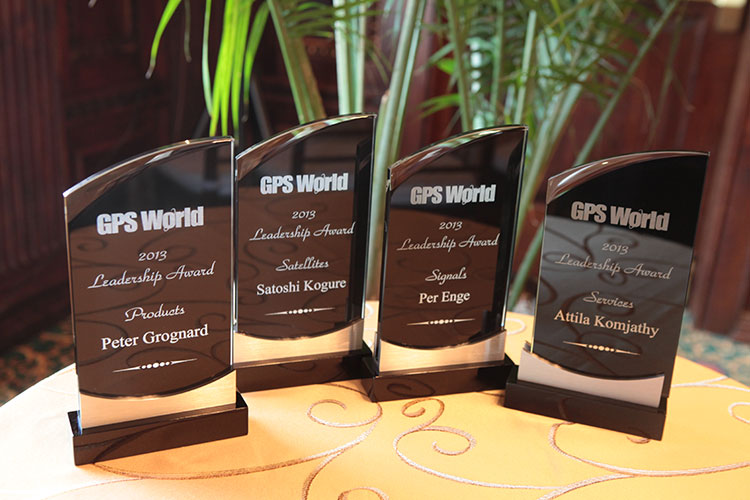
The GPS World 2013 Leadership Awards.
This year, as last, the gala was held in the sumptuous ballroom of the Hermitage Hotel in Nashville, which was built in 1910, exudes Southern charm, and is dedicated to General and President Andrew Jackson, a true son of the South. Harking back to our earlier theme concerning decision-making, President and General Andrew Jackson made many difficult decisions in his tenure and one of his greatest quotes certainly applies:
“Any man worth his salt will stick up for what he believes right, but it takes a slightly better man to acknowledge instantly and without reservation that he is in error.” — Andrew Jackson
And if you can’t quite remember your history, just pull out a $20 bill and there he is.
The food and camaraderie were outstanding as usual. The evening’s entertainment, which is always provided in the form of an original Alan Cameron game that has dinner guests participating in a novel event, this year was based on a clandestine “spoofer” at each table that had to be identified by Q&A only. It was a fine and fun evening, and for the award winners, it was a special evening. Four awards were given this year, to Satoshi Kogure, Attila Komjathy, Peter Grognard and my good friend Per Enge from Stanford. Congratulations to all the award winners — you never know, you could be a guest or an award winner next year. (A full report on this year’s dinner and awards will appear in the December issue of GPS World.)
ION Kepler Award
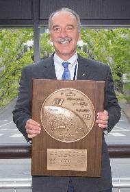
ION GNSS also presents prestigious awards at this event. This year, the coveted Kepler Award went to a good friend and colleague Dr. John Betz.
Dr. John Betz, winner of the ION 2013 Kepler Award.
Now, the ION GNSS awards committee keeps the name of the award winner totally secret, in a mayonnaise jar on Funk and Wagnall’s front porch. No wait, that’s another award, but they do keep it a closely held secret — so close, in fact, that this year’s award winner’s wife was not in attendance, even though she made the trip with him. So, while I had no idea who would win, I did happen to be sitting at Dr. John Betz’s table, right across from him, when the hints were announced by Dr. Jade Morton, the ION Satellite Division Chair and therefore also the luncheon and award master of ceremonies.
You see, there is a long-held presentation tradition associated with this award. No one knows who has won the award, but the announcement is not just blurted out. Rather, there are about ten hints given about the identity of the person. As the identify of the winner becomes apparent to those in the room, they are asked to stand up, signifying they have determined the identity of the award winner. It was clear to me who had won with the first hint, and of course it was clear to Dr. Betz as well. It was very interesting to watch his facial expression as he realized he had finally won. It dawned on him, and then there was a slight smile, but at the same time a very humble expression.
Dr. John Betz, a MITRE and ION Fellow, certainly deserves this award, and indeed, has deserved it for some time, so it was great to see his considerable accomplishments recognized. And, BTW, remember that you heard it here first: John is working on a book about GNSS that should be published in the next six months. It is not an edited volume, but rather an original work by Dr. Betz, and I for one can’t wait to read it. You can bet I will review it here at GPS World. Congratulations, John.
The other outstanding features of ION GNSS are the excellent and numerous exhibits, plus the time allowed between sessions that provide an excellent atmosphere for networking. And the excellent Nashville Renaissance Hotel, which is attached to the Nashville Conference Center, provided numerous quiet and semi-secluded locations for extemporaneous meetings and is a networking friendly location. The restaurants were excellent, as was the ubiquitous Starbucks barista-manned coffee shop located in the hotel. In other words, Lisa Beaty and her team always manage to choose an event location with accommodations and amenities perfect for this event. I am looking forward to next year in Tampa. Hope to see you there.
What Is Don Reading?
Both books reviewed this month came to my attention because, contrary to the old adage, I was able to tell a good book by its cover.
Phantom, by John Bell.
Phantom An Adventure Novel by Ted Bell
This is a singular novel, frighteningly prophetic in many respects and virtually unprecedented in the multitudinousgrappling-hook approach employed to entice the reader. This is not a criticism, merely an observation, as I obviously thoroughly enjoyed the yarn.
Many novelists “set the hook” by using the old standby, “It was a dark and stormy night…the wind howled, lightning flashed.” Many novelists hook you with rollicking train stories, or Romanoff tales of excruciatingly frigid White Russian winters with Tsars, Tsarinas and Tsarvitches. They hook you with stories of beautiful bounding yachts or fancy racing cars. Or, in the late Tom Clancy style, they hook you with stories of Air Force One and the president versus terrorists, or of course the most modern genre hook concerns terrorism in any guise. In Phantom, Ted Bell does not pick just one of these hooks, he includes them all and more. It is a riveting high-action drama that will keep you turning pages late into the night. The cherry on top of this action-filled sundae of a novel is that the story is really about Singularity (with a capital S), which Ted Bell and many computer scientists today define as “that epic moment in human evolution when artificial, or machine, intelligence (in the form of extremely powerful, superhuman computers) first matches and then exceeds human intelligence by a factor incalculable.”
Author Ted Bell.
In other words, this novel is about all the hooks mentioned, plus it foretells a time when computers obtain parity with and then rapidly exceed human intelligence. Now, if that is not a hook, I don’t know what is. If you are wondering how Ted managed to pull it all together, you will just have to read the book. You won’t be disappointed.
Remember, I was hooked by the cover, and it was not the picture of the beautiful yacht on the cover but rather the quote: “Ted Bell can really write” by James Patterson. Hook, line and sinker.
West with the Night, by Beryl Markham.
West With the Night An Autobiography by Beryl Markham (1902-1986)
The aviation enthusiasts among you may be scratching your heads and thinking, “Wait a minute, where have I heard the name Beryl Markham?” Beryl initially gained fame and notoriety not as a novelist but as a Kenyan-born British aviatrix in the tradition of Amelia Earhart. Indeed, Beryl was the first solo aviatrix to fly the Atlantic eastbound in the pioneering days of aviation. She was also an adventurer and renowned (the first female) racehorse trainer in Kenya, or in all of Africa, for that matter. She married three times, conducted numerous affairs, and was anything but conventional in most every aspect of her life. And, of course, she could write, and write very well. Many of her thoughts are so riveting and presented in such a unique way that you may find yourself going over them again and again just to experience the sheer beauty of her prose. The autobiography covers her early life and upbringing in Africa, and it is a tour de force of the written word. But don’t take my word for it, because this is the quote that caught my attention on the cover of this incredibly well-written piece of literature, that in my opinion should be required reading in every English Literature class today.
Beryl Markham in 1936.
“Written so well, and marvelously well, that I was completely ashamed of myself as a writer…[Markham] can write rings around all of us who consider ourselves as writers…It is really a bloody wonderful book.” — Ernest Hemingway
Until next time, happy navigating. Now, go register for a PNT conference, and then go read a good book.
Raytheon Company reached several milestones recently in its development of the GPS Next -Generation Operational Control System (GPS OCX). Lockheed Martin’s GPS III Non-flight Satellite Testbed (GNST) — a full-sized, functional satellite prototype currently residing at Cape Canaveral Air Force Station — successfully established remote connectivity and communicated with OCX during pre-flight tests.
GNST proved that it could connect with and receive commands from Raytheon’s Launch and Check Out System (LCS), a part of OCX that supports the satellite and mitigates risks prior to launch. The GNST received commands from Lockheed Martin’s Launch and Checkout Capability (LCC) node in Newtown, Pennsylvania via the OCX servers at Raytheon’s facility in Aurora, Colorado; the system then returned satellite telemetry to the control station. The tests mirror launch and early orbit testing planned for all flight vehicles.
“While we have connected OCX with ground-based simulators before, these tests were the first time that OCX and a GPS III satellite have actually communicated,” said Keoki Jackson, vice president for Lockheed Martin’s Navigation Systems mission area.
Ahead of Schedule. Raytheon received Interim Authorization to Test (IATT) security certification from the U.S. Air Force for OCX LCS four months ahead of schedule. The company received a one-year certification with no liens, meaning the government does not require any changes.
“Typically, IATT certification is given for six-month increments,” said Matthew Gilligan, Raytheon’s GPS OCX program manager and a vice president in Raytheon’s Intelligence, Information, and Services business. “The LCS one-year accreditation speaks to the quality of the information assurance design and threat protection.” The IATT not only includes the LCS, but also Lockheed Martin’s GPS III satellite support systems, Exercise and Rehearsal Training Tool, and Upload Generation Tool.
OCX is being developed in two blocks. There are seven iterations in Block 1 and one in Block 2. LCS is the fifth Iteration of Block 1; it successfully completed Critical Design Review in June 2013.
Early Orbit Exercises. Lockheed Martin and Raytheon also completed the third of five planned launch and early orbit exercises to demonstrate launch readiness of GPS III and OCX.
Exercise 3 demonstrated space-ground communications; first acquisition and transfer orbit sequences; orbit-raising maneuver planning and execution; and basic anomaly detection and resolution capabilities. In addition, the industry and Air Force GPS Directorate teams jointly executed mission planning activities, such as orbit determination and the generation of upload command files.
Two additional readiness exercises and six 24/7 launch rehearsals are planned before launch of the first GPS III satellite. The first flight GPS III space vehicle (SV-01) is expected to be available for launch in 2014, and launched by the U.S. Air Force in 2015.
Exelis Encryptors. Exelis delivered the first three of a planned 14 ground-based encryptors to Raytheon Company for OCX. Designed to automatically code and decode GPS signals, encryptors facilitate the exchange of user information by securely transmitting navigation payload data between the OCX ground station and the orbiting constellation of satellites.
Delivery followed successful thermal, electromagnetic interference and security verification testing. Exelis provides critical elements of software in the navigation processing subsystem that will enable controllers to better understand the exact position of GPS satellites. This helps ensure accurate navigation information is securely broadcast to users. In addition to encryptors, Exelis is building high-precision receivers for use in GPS ground monitoring stations and satellite signal simulators for testing purposes.
Exelis is also on contract with Lockheed Martin to provide the payloads for the GPS III satellites.
Signal Sentry 1000, an Exelis product that detects and locates GPS interference sources in 3-D by using longitude, latitude and altitude has demonstrated successful results during a planned field testing event held last week at the Vidsel Test Range in Sweden.
Taking advantage of the range’s remote location, Exelis was able to conduct tests of its Signal Sentry 1000 product using controlled jamming. The test was conducted without disrupting the GPS signal relied upon by civilian and military operations outside of the test range location. The test employed eight sensors positioned in an array pattern and showed that Signal Sentry was able to successfully detect and locate the jamming source. Having demonstrating interference detection and location capability, Signal Sentry 1000 can be deployed to collect actionable intelligence for law enforcement and protect GPS signal-dependent critical infrastructures.
Signal Sentry 1000 technology is a network of threat-detection sensors, which is part of a centralized server executing Exelis-developed proprietary location algorithms. These sensors can be strategically located around different types of critical infrastructure, such as shipping ports, utilities and government facilities to automatically sense and locate any intentional or unintentional GPS jamming source. Should a threat be detected, users would receive location information and actionable intelligence in order to determine an interference-mitigation plan.
“Exelis developed Signal Sentry 1000 to help protect critical infrastructure and to deliver intelligence to law enforcement operations that depend upon GPS availability,” said Mark Pisani, vice president and general manager of precision instruments and positioning, navigation and timing for Exelis Geospatial Systems. “Achieving this field test milestone proves that our detection technology works. The next step is to evolve this technology for our military customers.”
Signal Sentry 1000 builds upon Exelis expertise in the field of GPS and positioning, navigation and timing. Exelis payloads and payload components have been on board every GPS satellite for nearly 40 years. Today, Exelis is involved in GPS modernization initiatives, building tomorrow’s GPS III satellite constellation by developing and integrating the navigation payloads. Exelis is also providing navigation processing components, precision monitor station receivers, and key components of the system security design for the GPS Operational Control System, known as OCX.
Rockwell Collins has received a 2 million contract from the Air Force Research Laboratory (AFRL) to develop and demonstrate a secure software-defined radio (SDR) GNSS receiver capability.
GNSS typically refers to equipment that can receive signals from multiple navigation satellite systems including GPS, GLONASS, Galileo, and the Chinese BeiDou system. By utilizing multiple available satellite signals, a GNSS receiver can provide improved navigation performance and signal availability.
Hosted in a software-defined radio, this AFRL program will develop the security architecture required for the receiver equipment certifications. The arrival of modernized GPS signals and other constellations is changing the way the U.S. military accomplishes GNSS-based positioning, navigation and timing.
“Rockwell Collins is actively researching GNSS capability as it applies to the U.S. and global customer base,” said John Borghese, vice president of the Rockwell Collins Advanced Technology Center. “We’re leveraging decades of GPS experience and leading edge security architectures to produce a navigation receiver that will meet global needs.”
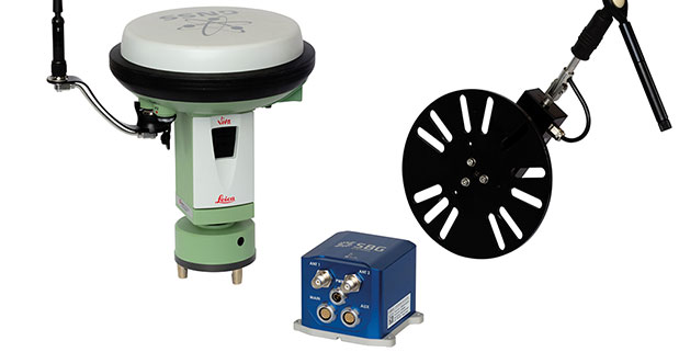
At ION GNSS+ this week, SBG Systems announced the release of the Ekinox Land Solution, an all-in-one solution combining the cost-effective inertial navigation system with an odometer, and a GNSS RTK reference station for smooth positioning in land applications. GPS positioning in urban canyons, forests, or tunnels has always been challenging. By taking the best of these complementary technologies, Ekinox Land Solution provides reliable positioning in an affordable package, the company said.
SBG Systems is exhibiting the system Wednesday through Friday at Booth 519/521 at ION GNSS+ in the Nashville Convention Center.
The combination of the Ekinox inertial navigation system with complementary technologies such as wheel-speed sensor (DMI) and RTK GNSS is the key to providing smooth vehicle positioning, even during GPS outages, SBG Systems said. To save users and integrators both time and money, the best equipment has been tested and selected to build a cost-effective and all-in-one package — Ekinox Land Solution.
Ekinox Land Solution is an integrated package built from the Ekinox Series, a range of inertial navigation systems based on robust and cost-effective MEMS technology. Mounted on a vehicle, Ekinox Land Solution provides real-time roll, pitch, and true heading (0.05° accuracy) while delivering a smooth position (2 cm). Data is output at 200 Hz and recorded in an 8-GB datalogger. Post-processing software is offered to increase attitude accuracy (up to 0.02°).
Ekinox Land Solution is designed to answer the growing need of vehicle real-time positioning, imagery sensor triggering, and data georeferencing at an affordable price. Examples of applications include mobile mapping, machine control, car motion analysis, and unmanned ground vehicle navigation.
The Ekinox series includes the Ekinox-A, and Attitude and Heading Reference System; the Ekinox-E, an Inertial Navigation System (INS) whose position feature depends on aiding equipment; the Ekinox-N, an INS with an embedded L1/L2 GNSS receiver; and the Ekinox-D, an INS with an integrated Dual Antenna GNSS receiver.
SBG Systems is a French supplier of MEMS-based inertial motion sensing solutions. The company provides a wide range of inertial solutions from miniature to high accuracy. Combined with calibration techniques and advanced embedded algorithms, SBG Systems products are designed for defense, industrial and research projects, such as unmanned vehicle control, antenna tracking, camera stabilization, and surveying applications.
The Air Force Institute of Technology (AFIT) and Locata Corporation have signed a Co-operative Research & Development Agreement (CRADA) to build and demonstrate new Locata multipath mitigation technology for use in GPS receivers. This cooperation is expected to leverage many years of proprietary Locata ground-based technology development to bring completely new capabilities to satellite-based GPS receivers, AFIT said.
The Air Force Institute of Technology, or AFIT, is the Air Force’s graduate school of engineering and management as well as its institution for technical professional continuing education.
The CRADA is specifically directed to evaluate Locata’s patented correlator and switching antenna technologies for use in positioning receivers running at GPS frequencies. Locata’s engineers will transfer knowledge and experience they have gained with existing Locata commercial systems to help AFIT design and build an initial multi-element GPS-based switching antenna prototype which is based on Locata’s patents. This will ensure AFIT researchers and engineers can familiarize themselves with the new antenna’s characteristics, and provide AFIT with an essential platform to develop GPS-specific versions of Locata’s correlator and switching algorithms. When built, AFIT intends to use its GPS receiver and the prototype switching antenna to physically demonstrate the feasibility of using Locata technology to improve GPS receiver performance.
An animation was created specifically to explain RF problems created by multipath and Locata’s VRay solution. The animation shows the first proof-of-concept 2D, 64-element antenna Locata’s engineers prototyped in 2011.
After initial prototypes are built, AFIT plans to design and test several other GPS-based versions of Locata’s switching antenna array to assess how Locata’s commercial antennas can be adapted to use cases which are of particular interest to the military. Designs already discussed with Locata include stand-alone antennas, arrays conformal to a vehicle’s frame (such as a Humvee’s roof or aircraft fuselage), and a version built into helmets.
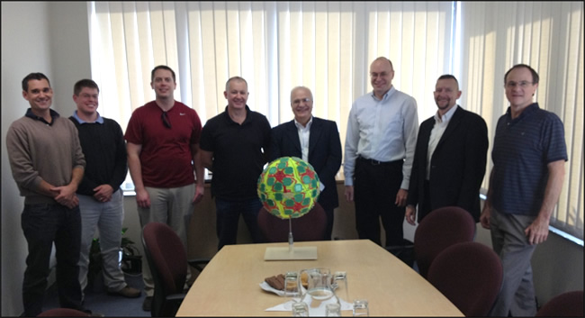
As a first step in implementing this CRADA collaboration, AFIT personnel visited Locata’s head office the week of April 29 for a detailed, wide-ranging introduction to the design fundamentals for this new type of antenna. Locata hosted AFIT’s John Raquet, Peter Collins and Jason Barhorst (see picture) in multiple engineering meetings where Locata’s current production version antenna was revealed for the first time, and then closely analyzed. AFIT and Locata engineers then workshopped the modification and design choices required to integrate Locata design into a GPS form-factor.
“If this CRADA is successful, Locata’s technology could enable a significantly improved technical performance and reduction in the cost of multiple-element GPS antennas,” said John Raquet, director, Advanced Navigation Technology Center, AFIT. “This will enable much wider adoption of the technology, resulting in more reliable GPS positioning for more users. We are excited to investigate this technology advance for the benefits it will potentially bring to American warfighters.”
“We are incredibly proud to once again be involved in a CRADA with the Air Force Institute of Technology, developing on the cutting-edge of navigation technology,” said Nunzio Gambale, CEO and co-founder, Locata Corporation. “Our previous LocataNet partnership with Dr. Raquet and his world-class AFIT researchers quickly taught us why this team is renown throughout the industry. The AFIT engineers bring an exceptional skill base to this important integration of Locata technology into GPS receivers. I’m certain that our collaboration, along with access to the USAF’s unmatched prototyping and testing capabilities, will deliver ground-breaking functionality for future GPS devices.”
AFIT expects at least one master’s degree to be awarded for the research tasks involved in the CRADA. Work against the approved CRADA project plan will commence immediately, and involve several other participants providing admin and lab support to AFIT and Locata. The final report produced by this CRADA will include results and measured performance of the Locata-enhanced GPS receiver and other design considerations gleaned from AFIT’s experience with the new Locata antenna and correlators.
AFIT-Locata Kick-off Meeting: This is the first picture ever released by Locata which shows their radically new switching antenna, a design that AFIT will now modify for use with GPS receivers. Pictured (L-R): Dr. Steve Hewitson & Ian Sainsbery (Locata engineers); Jason Barhorst (AFIT); David Small (Locata technology inventor), Nunzio Gambale (Locata CEO), Dr. John Raquet (Director, Advanced Navigation Technology Center, AFIT), Dr. Peter Collins (AFIT), Dr. Trevor Hobbs (Locata Director of R&D).
Chronos Technology, global timing and synchronization company, is exhibiting its anti-jamming technology at ION GNSS+ 2013 in Nashville, Tennessee, September 18-20.
Exhibiting at Stand 723, Chronos will be demonstrating the Chronos Sentinel system, which enables a light-touch deployment of GPS jamming detection for a short period of time and allows a GPS jamming report to be created to enable management to assess the threat.
The CTL3520 handheld GPS jamming detector by Chronos Technology.
Chronos will also be displaying various GPS products, including the new CTL3520 handheld GPS jamming detector and locator system aimed specifically at detecting GPS jammers hidden in vehicles. The unit can pinpoint even the weakest jammer and identify the vehicle in which the jammer is hidden, even in a busy multi-storey car park. Other applications include detecting vehicles with jammers at ports, fleet depots, airport car parks and taxi ranks.
In addition, Professor Charles Curry, managing director with Chronos Technology, is presenting a technical paper “GPS Jamming -Threat Scenarios” on Monday, September 16, at CGSIC, which precedes ION GNSS+ 2013.
For more information about ION GNSS+ 2013, visit www.ion.org