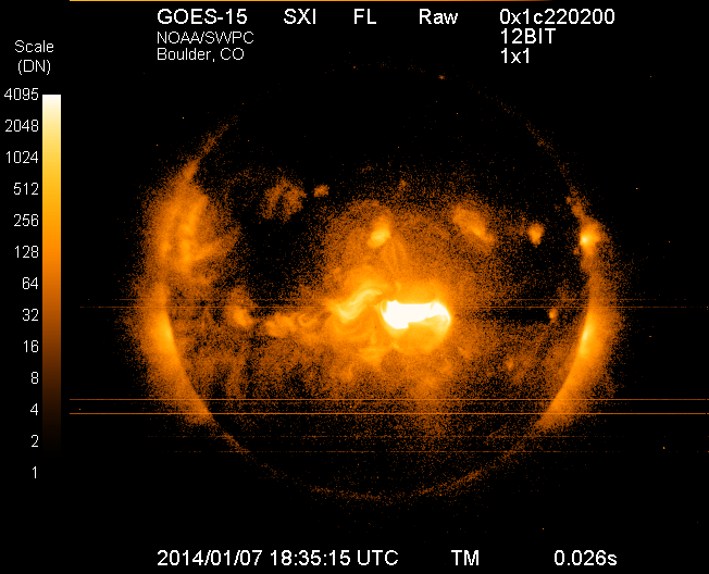
Image of the sun on Tuesday, Jan. 7, 2014, from the Solar X-Ray Imager on NOAA’s GOES satellite, taken just after the maximum emission of a solar flare. The eruption came from the middle of the sun and is directed toward Earth. This is the largest solar flare so far this year.
Forecasters at NOAA’s Space Weather Prediction Center said the sun’s coronal mass ejection (CME) that reached Earth on Jan. 9, unsettled the geomagnetic field but did not cause storm conditions to be reached due to the weak magnetic field. While there is still a chance we could see some geomagnetic storming, that threat is greatly diminished. The Space Weather Prediction Center is a division of the U.S. National Oceanic and Atmospheric Administration.
The sunspot in Region 1944 that produced the eruption at 1:32 p.m. EST Tuesday, January 7, has had no significant additional flaring and shows signs of decay.
How space weather affects real-time technology
Economies around the world have become increasingly vulnerable to the ever-changing nature of the sun. Solar flares can disrupt power grids, interfere with high-frequency airline and military communications, disrupt GPS signals, interrupt civilian communications, and blanket the Earth’s upper atmosphere with hazardous radiation.
Monitoring and forecasting solar outbursts in time to reduce their effect on space-based technologies have become new national priorities. And NOAA’s Space Weather Prediction Center (SWPC), part of NOAA’s National Weather Service, is the nation’s official source of space weather forecasts, alerts, and warnings.
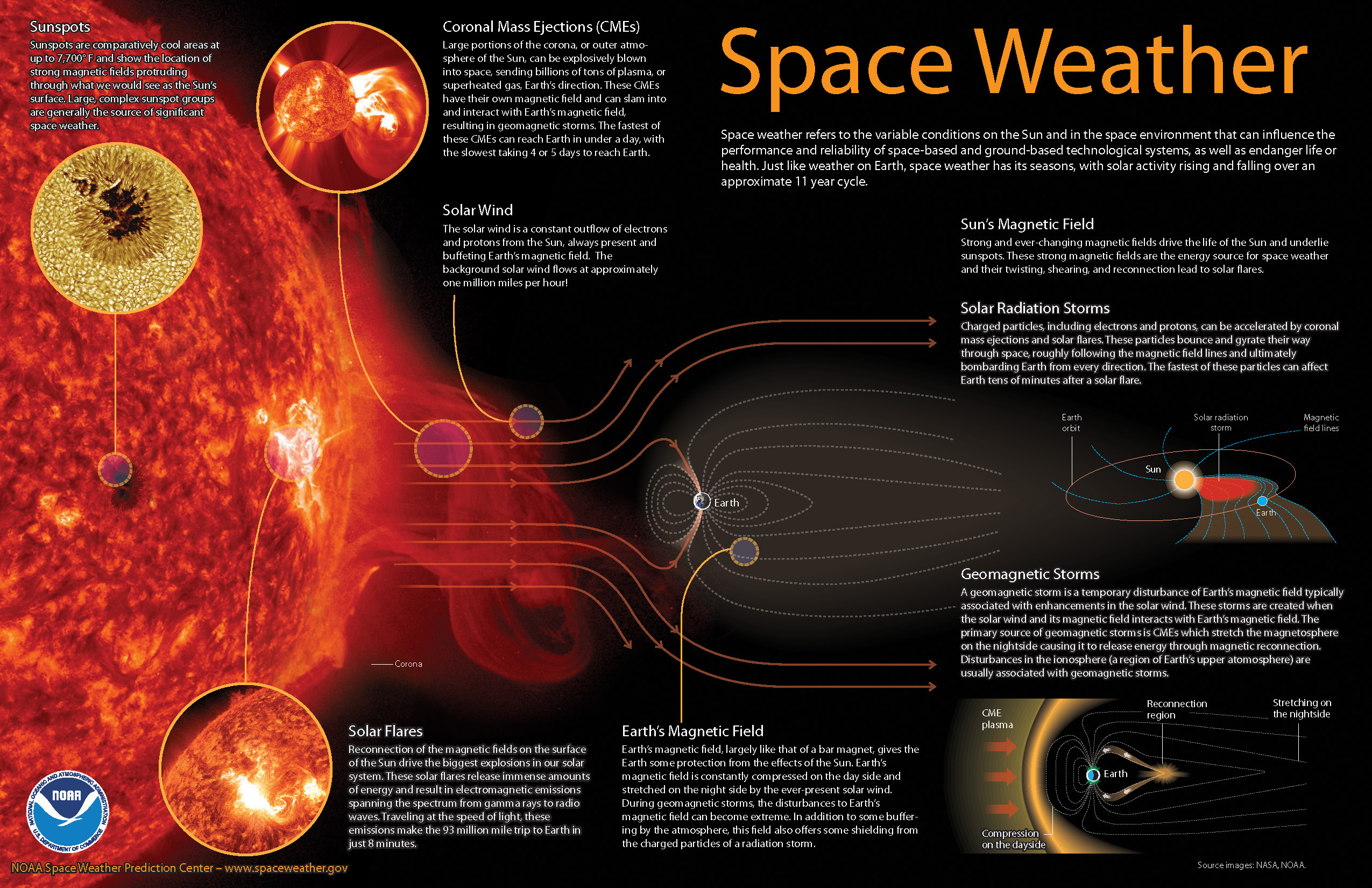
Space weather explained (source: NOAA).
Monitoring the Sun
To monitor events on the sun, SWPC staff utilize a variety of ground- and space-based sensors and imaging systems to view activity at various depths in the solar atmosphere. A worldwide network of USAF-sponsored optical observatories also provides space weather forecasters with detailed, plain-language information about activity in and around sunspot groups, as well as other areas of interest on the sun.
Space weather forecasters also analyze the 27-day recurrent pattern of solar activity. Based on a thorough analysis of current conditions, comparing these conditions to past situations, and using numerical models similar to weather models, forecasters are able to predict space weather on times scales of hours to weeks.
With effective alerts and warnings, NOAA is helping to minimize the hazards of space weather on technology. For example, satellite operations can be adjusted, power grids can be modified, and polar flights can be rerouted.
My original review of the first Yuma rugged tablet from Trimble MCS (Mobile Computing Solutions) was penned in August of 2011. My original plan was to have the review of the new Yuma 2 ready to go exactly two years later. But, as we all know, man plans and God laughs.
Actually, the problem, I must admit, is a bit more personal in nature; you see, I have been enjoying the Yuma 2 to such a degree that it was difficult to write about it because then I have to send it back. I have been selfish too long — read on for the review of the new Trimble Yuma 2 rugged tablet computer that is perfect for fieldwork, especially fieldwork involving GPS and GIS applications. Indeed, one Trimble marketing quote states:
“Bring Your Office to the Field for Efficient GPS/ GIS Data Management — The Trimble Yuma 2 rugged tablet computer is designed for ease of use and high performance mobility. Great for GIS applications — it’s like bringing a complete PC out into the field.”
While I totally agree with this assessment, the Yuma 2 is really so much more. It is not limited in any important function I could determine. As an example, I am typing part of this review on the Yuma 2 via a wireless Bluetooth keyboard and a high-definition Sony monitor hooked to the Yuma 2 via the new HDMI connector. Sweet!
Over the years, it has frequently occurred to me that oftentimes manufacturers have no idea of all the ways their equipment will be utilized in the field — although Trimble does a great job giving users ideas through the Trimble Dimensions showcase that will take place at the Mirage Hotel in Las Vegas November 3-5, 2014. If you are into rugged devices, GIS and GPS, or any of the areas listed at the Trimble Dimensions website, don’t miss this show. You will see the Yuma 2 and other Trimble devices and software put to the test and used in ways you could never imagine.
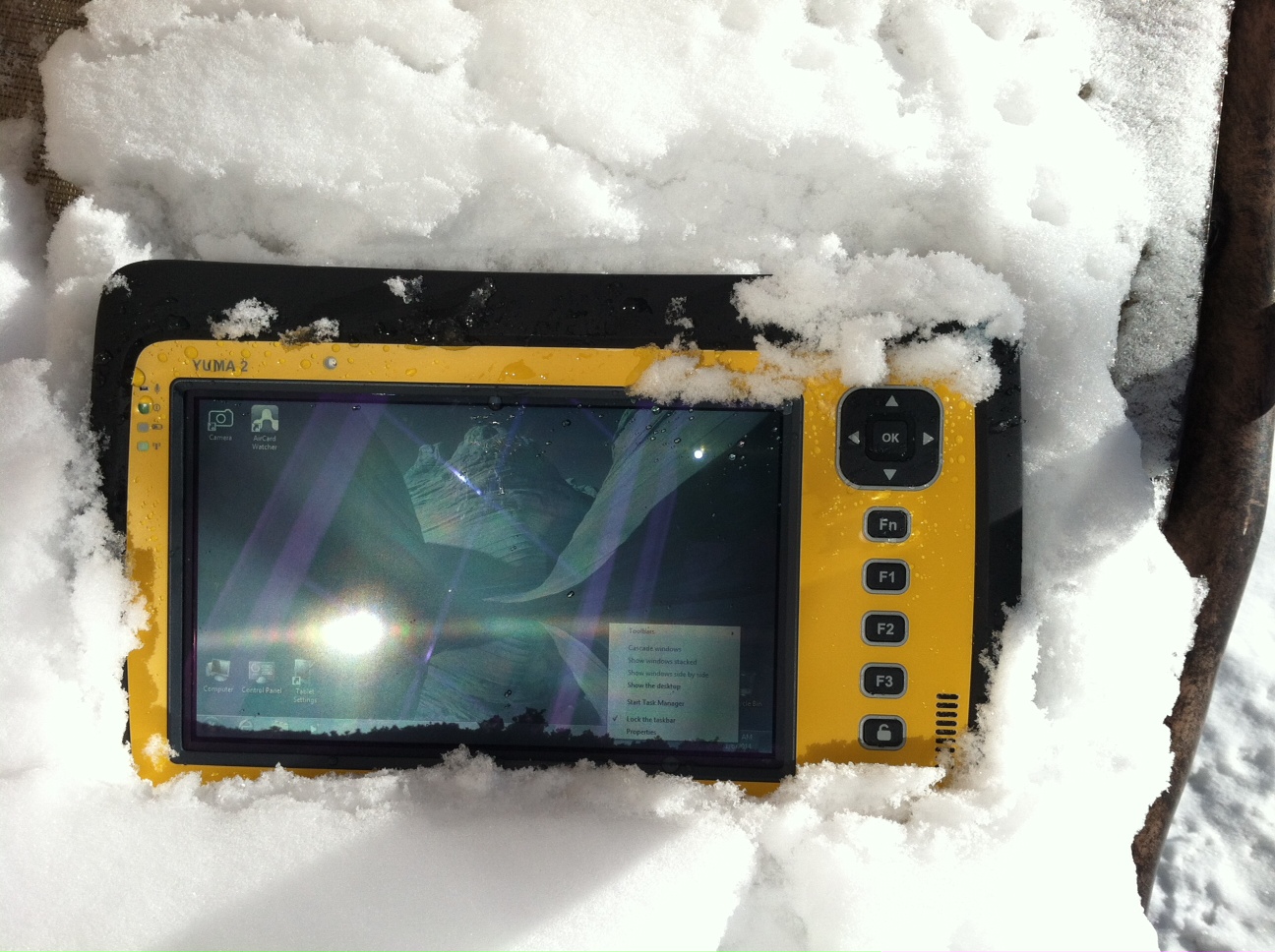
But, as usual, I digress. Let’s get back on topic and the Yuma 2 review. I put the Yuma 2 through all the normal wear-and-tear scenarios, which here in the foothills of the Rocky Mountains means severe cold (-20° F true temperature), snow, ice and altitude.
The Yuma 2 withstands tough conditions, including snow and ice.
During the six months I tested and evaluated the Yuma 2, I continued to receive several emails from users of the original Yuma rugged tablet. Three of those emails came from users in the Great Smoky Mountains. All three users operate the original Yuma in their business dealings, as well as for navigating around the Great Smoky Mountains and for recreational geocaching. One user, who would only agree to be identified as “Bailey” (he assured me that although he is retired military, his first name is not Beetle), intrigued me with his assertion that he has a crucial usability test he routinely performs on his GPS devices that I cannot easily conduct here in the Rocky Mountains. Beetle and other members of the Great Smoky Mountain Geocaching Society usually perform their Great Smoky Mountain Humidity and Fog tests at or around Clingmans Dome.
Clingmans Dome in the Great Smoky Mountains.
The National Park Service describes the 6,643-foot Clingmans Dome as being the highest point in Great Smoky Mountains National Park. It is the highest point in Tennessee, and the third highest mountain east of the Mississippi. Only Mt. Mitchell (6,684 feet) and Mt. Craig (6,647 feet) — both located in Mt. Mitchell State Park in western North Carolina — rise higher. Additionally, the cool, wet conditions at the summit of Clingmans Dome make the spruce-fir forest that grows there a coniferous rainforest. By now, you are probably saying, so what?
The “so what” is that Bailey says the humidity is sometimes so high that when geocachers hit the cooler temperatures and high humidity of Clingmans Dome, some devices have water streaming from inside the device, which is never a good thing. I checked with Trimble, and indeed their devices are made to survive these conditions and much worse, such as in many mountain jungles around the world. So Bailey, have no fear, your Yuma 2 will continue to work just fine in your moist environment. Consider that the Yuma 2 was designed and built at Trimble’s MCS facility in Corvallis, Oregon, which is just due East of a rainforest along Highway 1 on the Oregon West Coast. So you can bet the Yuma 2 is tested and rated for high humidity levels. Indeed, here are the humidity specifications: Cycles between -22° F to 144° F (-30° C to +60° C) at 90% RH (relative humidity), MIL-STD-810G, Method 507.5, Procedure II (Humidity Aggravated Cycle).
While we are detailing specs, let’s list all the formal specifications, and then we can delve into more detail about how we tested the Yuma 2 and how well it performed.
Physical
Size: (LxWxH) 9.6 in x 6.3 in x 1.5 in (246 mm x 160 mm x 40 mm)
Weight: 2.6 lb (1.2 kg) with standard batteries or 3.0 lb (1.4 kg) with extended batteries
Colors: Yellow, Gray, and Gray with Yellow border
Keys: Seven keys (OK, Logon, Power, Function, 3 user-programmable function keys) and 5-way directional keypad
Hardware Specifications
Processor: 1.6 GHz Intel Atom N2600 dual-core processor
Memory: 4 GB DDR3 DRAM of volatile memory
Storage: 64 GB or 128 GB SSD-Solid State Drive (Enhanced GPS: 128 GB SSD only)
Display: 7” 1024 x 600 hybrid reflective transmissive (transflective) with capacitive touch screen
Battery Options: Smart batteries with LED power indicators – Standard battery: Two 7.5v, 3000 mAh, 21.6 Wh or optional extended battery: Two 7.5v, 6000 mAh, 43.2 Wh
I/O: 3.5 mm audio jack, USB Host (2), HDMI, docking station I/O plate, DC input power
GPS Receiver: 1-2 meter accuracy (with SBAS) or 2-4 meter accuracy (with SBAS)
Radios: Bluetooth 4.0; Wi-Fi b/g/n
WWAN: Penta-band GSM 3.75 Data only module
Standard Features
• Transflective technology (TFT) direct sunlight readable color display
• Microsoft Windows 7 Professional OS
• Intel Atom N2600 dual-core 1.6 GHz processor
• 4 GB DDR3 DRAM volatile memory
• 64 or 128 GB solid-state drive
• Multi-touch capacitive touchscreen
• Rugged design certified to IP65 and MIL-STD-810G
• 3.5 mm audio jack and integrated microphone and speaker
• Outward facing autofocus 5 MP camera with LED Flash, photo and video recording capable
• Integrated Bluetooth 4.0
• Integrated Wi-Fi b/g/n and Wi-Fi Alliance Certified
• CCX (Version 4)
• GPS receiver, Enhanced 1-2 meter accuracy or 2 – 4 meter accuracy with SBAS
• Kensington security slot
• Accelerometer and Electronic Compass
• 3.75 G WWAN data connectivity optional
• Status LEDs for power, battery charging, Wi-Fi and 3G Data
• 12-month manufacturer warranty
Standard Software
• Microsoft Windows 7 Professional with Internet Explorer
• Camera software with geo-tagging
• Trimble GPS Information receiver control software
Standard Accessories
• Standard battery set (5+ hour)
• International AC Charging Kit with 4 adapters
• Capacitive Stylus with Tether
• Hand Strap and Display Cleaning Microfiber Cloth
Now that you have all the specifications and promises from Trimble, let’s look at how it compares to the original Yuma and then let’s get into how it works in everyday life as well as the not-so-routine scenarios.
Comparative Summary of Yuma and Yuma 2 Attribute
Yuma
Yuma 2
Touchscreen
Resistive dual touch
Capacitive multi-touch
Display Technology Sunlight Readability
Very Good
Excellent
Processor
1.6 GHz single core
1.6 GHz dual core
RAM
1 GB
4 GB
Solid State Drive
32 GB then 80 GB
Choice of 64 GB or 128 GB
GPS Accuracy
4 – 6 meter
2 – 4 meter
Battery Life3
4 hours with standard batteries8 hours with extended batteries
8 hours with standard batteries16 hours with extended batteries
Digital Connectivity
ExpressCard Modules
3.75G dual-mode (CDMA and GSM) option with SIM Card and Auto Carrier Recognition.
IP Rating
IP67
IP65
Pricing
$3999 Market Price for base configuration
$2999 Market Price for base configuration
First Impressions
The first thing most people notice about the Yuma 2 is its size. It is 1.5 inches shorter than a full-size iPad, while the high-definition screen is the same size and almost the same resolution as the iPad mini. With the ingenuous hand-strap attached to the back, the Yuma 2 is very maneuverable and easy to carry with you in most any situation. With the security cable, you can also attach it to a vest, backpack or even a belt loop for security. I tried all three options and it works well. For warfighters and first responders, this is ideal, as those users don’t need to worry about what happens if they should drop it. The Yuma 2 is IP65 MilSpec rugged, and I am frankly amazed at the punishment my demo unit survived. Just like the old Timex commercial — “It takes a licking and keeps on ticking.”
Attention Getter
I carried the Yuma 2 everywhere for more than six months, and it garnered a great deal of attention from military and medical personnel of all descriptions: policemen, firefighters, delivery drivers, utility workers, and several park rangers. Even our local refuse haulers spent time looking over the Yuma 2. It is just simply hard to ignore. Interestingly, something they all had in common is that initially they were all very dubious and nervous about dropping it, even on thick carpet, grass, ice or snow. But once they saw me do it, they all wanted to have a go and they did. My demo unit has easily been dropped more than 100 times from various heights, usually from about four feet onto almost any surface you can name, and it continues to perform like the pro-gear it is and was designed to be. It was even dropped twice, unintentionally of course, with the camera in video mode and the LED flash active. I have to admit that initially gave me pause, but the Yuma 2 came through without a hitch. Camera, video and flash all still function perfectly.
Field Capability and New Test
With the Yuma 2, I had an opportunity to test an application I have never run before, but which will now be a standard in my repertoire of applications — the functionality of an audio headset along with Dragon Speaking software.
Long story short, my daughter is a PsyD, or Doctor of Psychology, in private practice, and together we have been testing various software programs that convert her spoken notes into the written word. This is a more difficult task than you might imagine, given all the specialized medical and psychological terms employed in her everyday vocabulary. But the latest professional version of Dragon Speaking was absolutely up to the task, as was the Yuma 2. I installed the Dragon software and went through the brief training routine with the headset and microphone, and the result is the paragraph you are reading. What a great way to write an article.
Now my daughter and I are Apple aficionados. We have more than 21 Apple devices in our homes, and my daughter uses a 13-inch Apple MacBook Pro with a retina display in the office, which, while it is an awesome device, is not something you want to take into the field or into a first-responder situation, whereas the Yuma 2 fulfills the same functions and fits the “rugged” bill perfectly.
While the built-in speaker on the Yuma 2 is certainly adequate for voice recognition and for GPS commands, it is not something with which you will want to listen to iTunes, so I highly recommend the optional audio headset with microphone offered by Trimble and several other suppliers. For me, the new Bose headset model with microphone works extremely well, while remaining affordable, and the resulting fidelity is…well…certainly Bose quality — what more can I say!?f you want audiophile-quality music and speech-to-text transcription capability in the field, then the Bose headset and Yuma 2 combination can’t be beat.
Docking Station and HP ePrint
The unit we tested did not arrive with the optional docking station. However, we quickly determined that if you are going to be constantly, even daily, making the transition from field to office computer and want to work on the same computer, then a docking station is a must. Next time, say for the Yuma 3 review, for instance, we will request a docking station as part of the review hardware. There were so many times we wanted to print directly from the Yuma 2 that I wished fervently for a docking station. Then I found that the HP ePrint software worked just great on the Yuma 2 as long as you are in range of a printer capable of receiving the signal.
If you are on the road and need to print, you can do that via the cloud and ePrint no matter where you are. You can also print your documents to the nearest HP Public Print Locations, which include national chain locations for FedEx Office stores, UPS stores, Walgreens, numerous hotels, airport lounges, and more. Prices vary widely per page, but if you really need a hard copy, this is an amazing option that works well with the Yuma 2.
We tested this print option at our local Walgreens, and they were not initially aware they had the capability until we printed a test page and out it popped. Now they advertise the capability. We also tried printing from the parking lot of a local FedEx store, and since I have a FedEx account (we receive a lot of packages, as you can imagine), the page was waiting for us when we walked in the door and the bill was automatically charged to our FedEx account. It was an incredibly quick and painless process.
Camera and Flash
The 5 MP (megapixel) camera with automatic geotagging and LED flash work as advertised, although with the Yuma 2 we were also able to record a short video that played back flawlessly on the Yuma 2 and via the email attachment on my Apple iMac. The only caution here is that you are definitely capable of recording a video that, due to its size, may never work its way through the normal email system. Fortunately, the GPS World magazine servers and my “other office” servers are “unlimited,” so this was not a problem for us. However, when we attempted to send a 20-MB video file to a friend, his system would not initially authorize it. When we compressed the file, it went without a hitch. So, if you are going to be shooting a lot of video in the field, a good video software compression program is highly recommended. We tried no less than five different free video compression algorithms, and they all worked without a glitch. Note: Some programs, but not all, require the same software be resident on the receiving computer as well.
Power and Data Connectors
Fortunately, the power connector on the Yuma 2 device is heavy duty. It is reminiscent of the old serial port (RS232C) connectors with the screw receptacles on the port. Consequently, you will never have to worry about the power cables being disconnected, at least not on the Yuma 2 side. There is also an USB-RS232C dongle available that comes in handy for data logging from external sensors.
GPS Applications and Accuracy
While Trimble MSC is not publishing much about the GPS specifics, from a technical point of view in the Yuma 2, Trimbe is shouting from the rooftops that you can have nominal 2-4 meter accuracy or enhanced 1-2 meter accuracy (both with SBAS or Space Based Augmentation System – in the U.S., think WAAS or Wide Area Augmentation System) depending on your requirements. There is an option for an external GPS antenna, and while the three different RTK programs we ran on the Yuma 2 produced excellent and consistent sub-meter accuracies, RTK programs can be expensive. So with the Yuma 2 you should be capable of deriving accuracies anywhere from 4 meters to 4 cm, depending on your timing requirements, how much you want to spend, and sometimes your altitude.
Altitude
Which reminds me: I really got a kick out of the correspondence from the three geocaching Trimble Yuma users in the Great Smoky Mountains, mentioned at the beginning of this column, because all three made such a big fuss about the 6,000+ feet of altitude they routinely encounter when geocaching. My initial reaction to that concern is akin to that of the old codger mountain man in the great movie Continental Divide with John Belushi and Blair Brown in 1981.
John’s city-bred character mentions that being a smoker the high altitude in the Rocky Mountains is beginning to bother him, at which point the heretofore reticent old mountain man indignantly replies, “Mountains? These here are foothills, just bumps in the ground, these ain’t mountains!” Therefore, since my home sits at an altitude 1,000 feet or more higher than any of the Great Smoky Mountain peaks, and I can be at 14,000+ feet within a 20-minute drive and cross the Continental Divide in under an hour’s driving time, I understand the old mountain man’s consternation and directly relate it to the users’ concerns about the Great Smoky Mountains, which when compared to the Rocky Mountains in Colorado, are indeed bumps in the ground. I mention this only because at 7,500 feet with no obstructions, the Yuma 2 routinely processes 8-12 GPS satellites and reports accuracies far superior to those publicized by Trimble. So, while you should not necessarily expect the same level of accuracy I have reported here, you should probably expect accuracies in between what Trimble publicizes and the sub-meter performance we observe on a regular basis.
Software
I have frankly lost count of the multiple GIS and GPS software programs I ran on the Yuma 2, but they all basically ran flawlessly, both the free apps and the more costly programs. The only issue I encountered is that some GPS programs require utilizing different ports and transmission speeds. However, since these parameters are user definable on the Yuma 2, it never presented any serious obstacles. Caveat emptor, for here I will remind users of the old axiom, “You get what you pay for!” The free GPS and GIS apps work fine, but the amount of metadata and accuracy provided by some of the more costly applications is nothing short of amazing. If you plan to use the Yuma 2 for scientific applications and desire onboard processing, then the more costly software programs are the applications I would recommend. If the Yuma 2 is just a data logger or positioning device, then the free applications work well.
Bottom Line
The Yuma 2 is an amazing machine. It is everything a high-end laptop should be and more in a ruggedized format with a Gorilla Glass high-definition display touchscreen that should be reassuring to users in the field.
For government users, the rugged Yuma 2 tablet with a Selective Availability Anti-Spoofing Module or SAASM option would be the perfect choice, and far superior to anything else in the field today, especially for our military. My sources tell me there are thousands of Yuma and Yuma 2 tablets in the field today, and the addition of a SAASM module would make them more secure and usable by our military users for all their tasks. Imagine one secure tablet that meets all your needs. I think our warfighters deserve the best, don’t you?
If you currently accomplish fieldwork and transfer data between two computers, and make use of GIS and GPS data, then the Yuma 2 is the machine of choice for you because it will do the work of both computers and display/output data through the HDMI interface or through the wireless ePrint capability, especially if you opt for the optional docking station. The SSD (solid state drives) are super fast, and since there are no moving parts on the Yuma 2, you may well find it is faster and more dependable than your current office laptop or even desktop computer. I highly recommend it.
Until next time, happy navigating and take a rugged computer out for a spin.
Artist’s concept of a GPS III satellite in orbit, courtesy of Lockheed Martin.
Air Force Orders GPS III Satellites 05 and 06 from Lockheed Martin
A December 12 contract modification provided Air Force funding to Lockheed Martin to complete the fifth and sixth GPS III space vehicles (SV 05-06). Lockheeed originally received funding to procure long-lead parts for satellites five through eight (SV 05-08) in February 2013.
The $200,700,415 cost-plus-incentive-fee modification (P00276) on an existing contract (FA8807-08-C-0010) for GPS III space vehicles 05 and 06 means that work will be performed at Littleton. Colorado and Clifton, New Jersey, and is expected to be completed by Dec. 14, 2017 for space vehicle 05 and June 14, 2018 for space vehicle 06. The Air Force Space and Missile Systems Center Contracting Directorate, Los Angeles Air Force Base, California, is the contracting activity.
Galileo Achieves First Airborne Tracking
The European Space Agency’s Galileo satellites have achieved their first aerial fix of longitude, latitude, and altitude, enabling the inflight tracking of a test aircraft.
ESA’s four Galileo satellites in orbit have supported months of positioning tests on the ground across Europe since the first fix in March. Now the first aerial tracking using Galileo has taken place, determining the position of an aircraft using only its own independent navigation system.
The milestone took place on a Fairchild Metro-II above Gilze-Rijen Air Force Base in the Netherlands on November 12. It was part of an aerial campaign overseen jointly by ESA and the National Aerospace Laboratory of the Netherlands, NLR, with the support of Eurocontrol, the European Organisation for the Safety of Air Navigation, and LVNL, the Dutch Air Navigation Service Provider.
A pair of Galileo test receivers was used aboard the aircraft, the same kind employed for Galileo testing in the field and in labs across Europe. They were connected to an aeronautical-certified triple-frequency Galileo-ready antenna mounted on top of the aircraft.
Tests were scheduled during periods when all four Galileo satellites were visible in the sky. The receivers fixed the plane’s position, as well as determining key variables such as the position, velocity, and timing accuracy; time to first fix; signal-to-noise ratio; range error; and range–rate error.
Testing covered both Galileo’s publicly available Open Service and the more precise, encrypted Public Regulated Service, whose availability is limited to governmental entities.
Flights covered all major phases: take off, straight and level flight with constant speed, orbit, straight and level flight with alternating speeds, turns with a maximum bank angle of 60 degrees, pull-ups and push-overs, approaches and landings.
The flights also allowed positioning to be carried out during a wide variety of conditions, such as vibrations, speeds up to 456 km/h, accelerations up to 2 ghorizontal and 0.5–1.5 gvertical, and rapid jerks. The maximum altitude reached during the flights was 3,000 meters.
GPS III Prototype Proves Constellation Compatibility
The Lockheed Martin prototype of the next-generation GPS satellite, the GPS III, has proven that it is backwardly compatible with the existing GPS satellite constellation in orbit.
During tests concluded on October 17, Lockheed Martin’s GPS III testbed successfully communicated via cross-links to Air Force simulators of the current GPS constellation in orbit. The current GPS constellation includes GPS IIR, GPS IIR-M, and GPS IIF satellites.
Testing also demonstrated the ability of an Air Force receiver to track navigation signals transmitted by the GPS III Nonflight Satellite Testbed (GNST). The GNST is a full-sized, functional satellite prototype at Cape Canaveral Air Force Station.
“These tests represent the first time when the GNST’s flight-like hardware has communicated with flight-like hardware from the rest of the GPS constellation and with a navigation receiver,” explained Paul Miller, Lockheed Martin’s director for GPS III Development. “This provides early confidence in the GPS III’s design to bring advanced capabilities to our nation, while also being backward-compatible.”
The first flight-ready GPS III satellite is expected to arrive at Cape Canaveral in 2014, for launch by the Air Force in 2015.
GPS III satellites will be the first GPS space vehicles with a new L1C civil signal designed to make it interoperable with other international global navigation satellite systems.
The GNST has helped to identify and resolve development issues prior to integration and test of the first GPS III flight space vehicle (SV 01). It has gone through the development, test, and production process for the GPS III program first, significantly reducing risk for the flight vehicles, improving production predictability, increasing mission assurance, and lowering overall program costs.
The GPS III team is led by the Global Positioning Systems Directorate at the U.S. Air Force Space and Missile Systems Center.
Lockheed Martin is the GPS III prime contractor, with teammates including ITT Exelis, General Dynamics, Infinity Systems Engineering, Honeywell, ATK, and other subcontractors.
Good News for Users and Manufacturers
The U.S. Air Force is directing transmission of continuous CNAV message-populated L2C and L5 signals starting in April 2014. The move is designed to help development of user equipment compatible with the civil signals. Full text of the CNAV memo appears below.
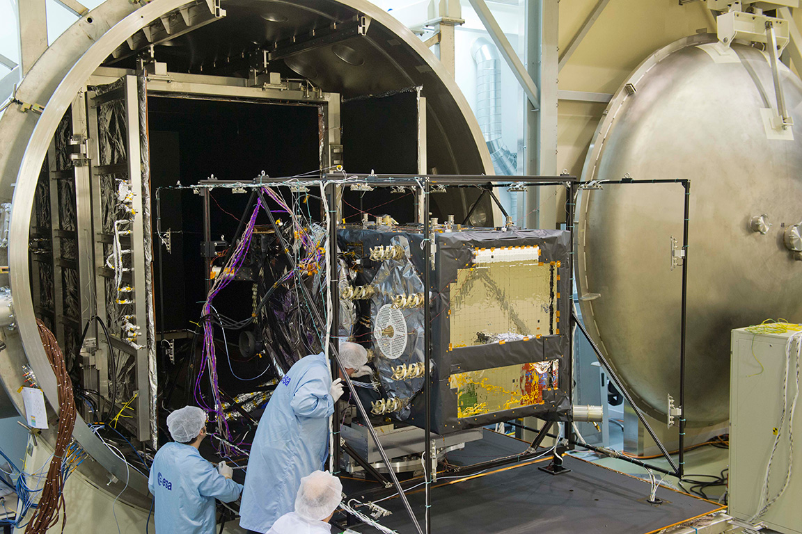
Galileo FOC Satellites Endure Simulated Space Tests
The European Space Agency’s newest Galileo satellite has emerged from five weeks of simulated space conditions. On November 29, a hatch slid open to end its thermal-vacuum test, a milestone on the way to orbit.
The satellite was placed in the 4.5-meter-diameter Phenix chamber in ESA’s ESTEC Test Centre in Noordwijk, the Netherlands, in late October. Once inside, the air was pumped out to create a space-quality vacuum. Temperature extremes were also reproduced, with the six copper walls of the thermal tent cooled by liquid nitrogen down to –180°C.
A second Galileo vehicle has been undergoing the same rigors at the site, along with a vibration and shock test to reproduce separation from the launcher. Thermal-vacuum testing on the second model will begin in early 2014. The two satellites will be launched on a Soyuz rocket from Europe’s Spaceport in French Guiana in mid-2014.
The next satellite is expected to arrive at ESTEC in March, with further satellites following every seven weeks or so. A total of 22 FOC satellites are being built by OHB in Germany, with navigation payloads being delivered from Surrey Satellite Technology Ltd. in the UK.
The first Galileo Full Operational Capability satellite emerges from the Phenix test chamber after five weeks of thermal–vacuum testing.
Raytheon Intelligence and Information Systems has been awarded a change order for work that costs up to $8.5 million on its existing contract to ensure that the new military signal, M-code, works with the GPS Operational Control System, according to an announcement from the Pentagon as reported by Space News.
Raytheon is building the ground station (OCX) for a new generation of satellites that will bring more safety and precision to GPS. The contract modification is to assure implementation of M-code capabilities across OCX Block 1 and 2. M-code is the new highly secure, anti-jam signal designed for the GPS III constellation. The current GPS ground control system lacks M-code capability.
The OCX is designed to work with the advanced GPS III positioning, navigation and timing satellites, slated to start launching in 2015, and also will be backwardly compatible with existing GPS satellites.
Raytheon won the $886.4 million prime contract to develop the OCX in February 2010. Work will be performed at Raytheon’s facility in Aurora, Colorado, and is expected to be completed by August 31, 2016.
The Air Force Space and Missile Systems Contracting Directorate, Los Angeles Air Force Base, California, is the contracting agency.
Details on the contract change order: Raytheon Intelligence and Information Systems, Aurora, Colo., has been awarded an unpriced change order (P00112) with a not-to-exceed of $8,595,748 on an existing contract (FA8807-10-C-0001) for M-Code Implementation on the Operational Control System. The contract modification is to assure implementation of M-Code Capabilities across OCX Block 1 and 2. Work will be performed at Aurora, Colo., and is expected to be completed by Aug. 31, 2016. Fiscal 2014 research and development funds will be obligated at definitization. The Air Force Space and Missile Systems Contracting Directorate, Los Angeles Air Force Base, Calif., is the contracting activity.
Handheld Group, a manufacturer of rugged mobile computers, PDAs and smartphones, has started shipping the Nautiz X1. The Nautiz X1 is a rugged enterprise smartphone — it’s waterproof, dustproof, shock-resistant and can handle extreme temperatures, yet it’s also slim, lightweight and smartly designed for both work and play, the company said.
The Nautiz X1 is now shipping to customers worldwide. Interest in Handheld’s ultra-rugged smartphone has been tremendous, and the first batches are completely sold out, the company said.
The Nautiz X1 is part of the Nautiz product family of rugged and ultra-rugged PDAs and smartphones. It has an IP67 ingress protection rating, which means it’s fully dust- and waterproof and can withstand immersion in water, and it also meets stringent MIL-STD-810G military test standards for enduring humidity, vibration, shock and extreme high and low temperatures.
“As a company specializing in rugged computers, we know our customers expect all our products to be built rugged from the inside out. The Nautiz X1 is no exception — it comes with the reliability and sturdiness of an ultra-rugged computer,” says Product Manager Johan Hed of Handheld Group. “People are increasingly using their smartphones all the time, everywhere, and they’re expecting mobility and connectivity anytime, anywhere, and in all environments and weather conditions. The Nautiz X1 ultra-rugged smartphone is a natural choice, as it’s built to survive these challenges.”
“This is the toughest smartphone ever built,” said Jerker Hellström, CEO of Handheld Group. “We see a huge demand for truly rugged smartphones among field professionals and outdoor enthusiasts who want to be constantly connected. We’re excited to see the great response this product receives from the market.”
The Nautiz X1 is slim and lightweight, weighing in at less than 180 grams (6.3 ounces). It has a 4-inch special sunlight-readable capacitive touchscreen and ultra-durable Gorilla Glass. It runs on a powerful 1 GHz dual-core processor and has 1 GB of RAM. It features Bluetooth, Wi-Fi, a compass, a professional u-blox GPS, and a 5-megapixel camera. The Nautiz X1 comes with Android 4.0 (Ice Cream Sandwich) or Windows Embedded Handheld 6.5 operating system, and runs on both GSM and CDMA networks. Multiple battery options enable a full day’s work in the most demanding environments.
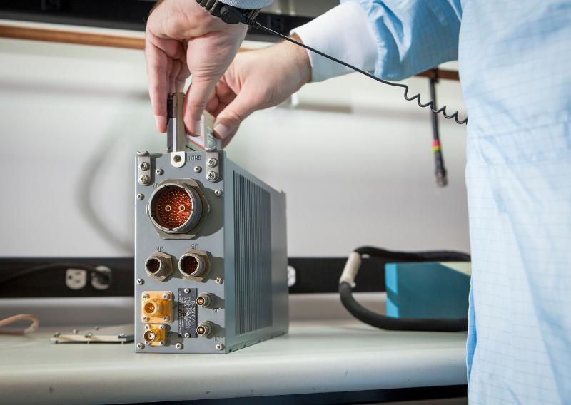
The open architecture design of MAGR 2000-S24 allows modernization and upgrade of GPS functional capabilities through replacement of a single electronics module.
Raytheon Company has received a $15.8 million contract order for its MAGR 2000-S24 miniaturized airborne GPS receiver. The order, which includes new production and sustainment of existing systems, is the first under an Indefinite Delivery-Indefinite Quantity (IDIQ) contract awarded to the company in September 2013 by the U.S. Air Force Space and Missile Systems Center.
Raytheon recently completed its 2,000th delivery of MAGR 2000 systems to the U.S. military and its allies in Europe, the Middle East and the Asia Pacific region. Flown on 20 types of fixed- and rotary-wing platforms, the MAGR 2000-S24 provides unparalleled navigation accuracy and resistance to interference and jamming. Its open architecture design allows for insertion of future GPS modernization enhancements, such as the new military code signal, without having to replace the unit itself.
“With the increasingly sophisticated threats posed by potential enemy nations, our customers recognize Raytheon as the gold standard for highly secure, highly adaptable GPS receivers for the airborne military environment,” said Sharon Black, director of GPS and Navigation Systems for Raytheon’s Space and Airborne Systems business. “Our innovative MAGR 2000-S24 design makes future unit replacement virtually unnecessary. Capability enhancements are as simple as swapping out the electronics module card, providing a highly cost-effective path for keeping fleets up-to-date with the latest GPS technology.”
The current MAGR 2000-S24 IDIQ contract extends through September 2017. The first order of 323 production units is scheduled for completion in June 2015.
Reportstack has announced a new report on The Global Military GPS/GNSS Market 2013-2023. This report offers the reader detailed analysis of the global military GPS/GNSS market over the next 10 years, alongside potential market opportunities to enter the industry, using detailed market size forecasts, Reportstack said.
A satellite navigation system provides GPS positioning from a global perspective, and is therefore of utmost importance for modern-day military operations, which rely on accurate real-time data on hostile forces in order to carry out precision attacks, Reportstack said. It is here that GPS/GNSS devices assume an important role, as they are imperative to transfer signals from these satellites back to earth.
The U.S. is the highest spender on military GPS/GNSS navigation, and is responsible for 42.9% of the global military GNSS devices market. Others major spenders in this sector include Russia, the UK, China and India. In July 2013, India launched the IRNSS-1A, the first of seven satellite constellation to be deployed under the Indian Regional Navigation Satellite System (IRNSS) program to be completed between 2015-2016. And China’s BeiDou is scheduled to be operational by 2020.
Another factor driving the market is the integration of satellite navigation technology with other navigation systems, such as the inertial navigation system (INS) and gyro, as GPS devices are to be used in order to decipher data correctly, Reportstack said.
The increasing demand for satellite navigation and communications is driven primarily by the desire of militaries to monitor more areas and derive accurate information by a range of GNSS receivers/sensors in the shortest time possible. Major military aircraft and helicopters are dependent on GPS embedded INS systems for effective navigation. Similarly, naval vessels and guided munitions are increasingly relying on the collaboration of laser, gyro, INS, and satellite navigation technologies to derive accurate real time data.
Furthermore, it has been observed that the usage of standard positioning services/open service receivers, which use unencrypted signal for non-combat purposes has increased, and is expected to drive demand and encourage expenditure, Reportstack said. The military GPS/GNSS technology is expanding its horizon beyond the basic characteristics of navigation and tracking. The use of GPS, in conjunction with a number of software applications, has expanded its use in military operations. A number of new technologies are now embedded with GPS receivers to produce a more sophisticated military tool.
Recently, a Swiss-based company developed a device called GPS Log Book based on u-blox technology. The new device has extended the scope of GPS technology to the administrative side of military operations. It provides an easy way for military drivers to automatically keep an accurate travel log book which can be securely accessed later from anywhere via a web interface. Information logged includes route, speed, and distance traveled. It also keeps a close record of fuel used by the vehicle, based on the distance traveled at various speed levels.
The advent of Differential GPS (DGPS), an enhancement to GPS, which provides improved location accuracy, from the 15-meter nominal GPS accuracy to approximately 10 cm, has further expanded the scope of GPS in missile technology. The intercontinental ballistic missiles, which are capable of hitting targets across thousands of miles navigation, use inertial navigation with DGPS receivers. The advent of DGPS is expected to be one of the most significant steps in accurate missile targeting for militaries across regions.
The companies mentioned in this report are Northrop Grumman, Raytheon, Rockwell Collins , Lockheed Martin, ITT Exelis, Thales, and BAE Systems. More details and table of contents about this report can be found by visiting The Global Military GPS/GNSS Market 2013-2023 report.
Remembering a Time before GPS — and a Lifelong Friend
One of my oldest and best friends died today – and he was just a kid, only 62. In the prime of his life, and yet I know he led a very full life and had no regrets when he passed on to that highway in the sky — somewhere where he will hopefully not have to ask directions, because neither one of us was very good at that. Indeed, in our youth, both Gordy and I were GPS-challenged long before GPS was a gleam in Dr. Parkinson’s eye.
I first came across Gordon F. Oates, Jr., and his future wife Valerie at a private media party more than 40 years ago. Gordon was the nephew of Warren Oates, the famous actor — who was a regular on the Gunsmoke and Rawhide westerns in the late 1950s — black and white television ring a bell? Warren Oates was certainly known to have a wild streak in him. As I grew to know Gordy, I always suspected he inherited a bit of Warren’s independent DNA. But I digress — Gordon and I teamed up one summer while I was attending the University of Kentucky, both as a student and as the managing editor of the Kentucky Wildcat newspaper, and Gordon was attending the University of Louisville, also in Kentucky. Our common theme when we met was we were both working for the Courier Journal newspaper at the time. Not that we were well-known columnists or writers — no, we were just two young men of the South from two of Kentucky’s finest universities trying to make a few extra bucks during the summer break. Over the two summers of 1970-71, I think we visited every city, tiny berg, holler, village, and wide spot in the road that existed in eastern Kentucky.
After the Courier Journal paired Gordon and I as a team, assigned us to cover eastern Kentucky, they then notified us we would need to provide our own transportation. I had a 1965 Fiat Spyder that I had brought home after attending college in Europe a few years before, which would barely fit my six-foot-one frame and a suitcase. Gordy, although two years my junior, was a few inches taller, loved basketball, and outweighed me by fifty pounds, so the Fiat was not an option for the both of us. But Gordon’s mode of transportation — Wow! Gordy had a brand-new 1970 bright red 320 Boss Mustang with a huge spoiler. The specs state the original Boss Mustang capable of accelerating from 0-60 mph in 6.9 seconds. The quarter mile took 14.6 seconds at 98 mph and we routinely and brazenly tested those specifications in the mountains of Appalachia — fog, rain, snow, coal trucks, slow-moving farm tractors, blind curves, thousand-foot sheer drops and all. The Dukes of Hazard had nothing on us “City Slickers” (more on that appellation shortly) from the Courier Journal. We visited Hazard and Walker Town, Kentucky, several times those two summers, and although we never met Daisy Mae, we met a young lady whose story changed both our lives.
Lost? Never. Bewildered? Maybe.
When I say we visited several places several times, our repeat visits were not always planned or even generally on purpose. You see, Gordon always drove the Mustang, and while he loved that car and he loved to drive, he was also always a happy soul and not overly concerned with directions. Even when I gave him directions, he could not always hear me because we listened to whatever country station he wanted — driver’s prerogative, of course, and there were few choices — for sure Loretta Lynn and Dolly Parton were on every station singing as loud as the volume knob in that Mustang would take them. Plus, as the driver in charge, it was also Gordy’s privilege not to ask directions. That’s right, it’s a guy thing, and yes, I said not to ask directions. Many of my masculine readers will be familiar with the concept. After all, how could two college boys from the big city of Louisville, the biggest city then and still today in the Commonwealth of Kentucky, ever admit to being lost in the mountains of Appalachia? And how could we ever stoop so low as to ask directions, especially since every single time, rain or shine, we stopped for gas, which was frequently at those speeds, a huge crowd gathered to gawk at that bright red Boss Mustang? Now, just how could we lower ourselves to admit we were lost? Horrors! I can hear the snickers now — big city slickers are lost! So Gordy drove like a bat out of the proverbial nether regions and I attempted to read the map. Ever try to read a Texaco map while careening around curves in the mountains of Appalachia, while avoiding coal trucks and trying to keep your lunch down? Losing your lunch in the Mustang was not an option, just as it was not such a good idea to look down at the rusted hulks of automobiles strewn along the mountainside or at the river gorge so far below you could barely make out the water.
I did not have an inkling then that anything like GPS (Global Positioning System) would be commonplace just 20 years later, but it would have been merely one of the many things I would have been praying for had I known. So we made do with Gordon’s Positioning System — which invariably failed, except for the day it took us to a tiny mountain village in far eastern Kentucky.
Pikeville
We rarely spent more than 30 minutes in one of the tiny hamlets or hollers in Kentucky’s eastern mountains, better known to the world as Appalachia. But I know Gordon never forgot and I will never forget the cold and rainy late fall day we stopped in Pikeville, pronounced proudly by the young lady in the café that day as “PYKE-vull” as in “Howdy gents, water you two city slickers adoin’ in Pikeville?”
We were there merely to have lunch at the only café in the entire village. It featured six tables with mismatched cane-bottom chairs, sawdust on an aromatic, weathered and stained (with what, I did not want to know) pine floor with knotholes every few feet, and a menu that seemingly the locals and our waitress knew by rote, since we never saw one. We, of course, according to our very young waitress, would have the Blue Plate Special, consisting of “burgers, fried ’taters with catch-up, cola and pie.” She “allowed” as we could have a fried egg or gravy on our burger for an extra five cents. I think we both passed.
It was actually the life story our waitress haltingly related that caught and held our attention that day. She said she was 14 years old — our best guess was twelve. She wore a flour-sack dress that could only be described as threadbare — but if you looked carefully, you could still read “50# lbs of bread flour by weight” right on the back of her dress. She wore no socks or shoes, and this was in late November, just the week, according to her, afore Thanksgiving in 1970. Come on back next week, she said, and we could have turkey with all the trimmin’s. Which we hoped meant more than a fried egg and gravy.
Although she spoke with a strong Kentucky burr, she obviously knew the limited menu by heart, as we never saw her write down an order. When she spoke to the cook in the kitchen, her strong accent made her almost indecipherable, even to two Kentucky boys. And, without a doubt, she was clearly the one who gave us the handle “Big City Slickers” and informed us that she “hain’t never read no ‘pepper’ from the big city.” We talked while we were waiting for our food, as everyone else in the café was, as she exclaimed, “out pawin’ and fawin’, over the big red car in the rain with’n the horse on it, parked right in front.” That is, except for an old gentlemen sitting in the corner by the roaring fireplace, who was chewing and spittin’ tobacco. Obviously a favorite appetizer for folks in Pikeville. But I digress — our obviously underage waitress wanted to talk, and she told us about her life back in the holler, living in a log cabin/tarpaper shack over a hog pen. Her daddy was a part-time coal miner and moonshiner, who could get us some shine (moonshine) iffin we wanted it — the cops didn’t make no never mind, she said. She reckoned she was one of eleven children from her Momma, who were livin’! She did not say how many of her brothers and sisters had passed on, but it was obvious the number was not small. She went to school when the truant officers caught her and made her go, but her family needed the five dollars a week plus tips she got from the cafe.
Consider that back in 1970 regular gasoline went for about 36 cents a gallon in Appalachia, cheaper than in Louisville I remember, and it took just about six dollars every time we filled the tank on the Mustang. And this young lady worked as a waitress at twelve years of age so she could make $5 a week plus tips for her family. Of course she said she also received her meals “free” and could occasionally take some food home “if’n she could carry it the five miles yonder to the holler.”
Please don’t get the wrong impression; neither Gordon or I ever made fun of this young lady, of Pikeville, Kentucky, or of Appalachia. We had just never encountered anyone like her or her circumstances previously. After all, we were “big city slickers,” university men, newspapermen, and this young lady was proud of her story — there was not a single “woe is me attitude” on her behalf ever in the short time we knew her. Quite the opposite: she was obviously responsible, and very proud to have her job. She was forthrightly proud of her Momma and her family, and as she said, she respected her Daddy. She was getting a new dress for Christmas, but her only lament was that she had never owned a pair of shoes. But then she said, “It is hard to miss something you never had.
Prior to visiting this particular café in Pikeville, Gordon and I never ate more than one meal in any one restaurant or café for the entire two summers. Moving from town to town several times a day was the name of the game in the newspaper business. However, somehow Gordon kept “getting lost,” and we ate nearly every meal at the same café in Pikeville for three days straight, until it was just too far to “get lost to” anymore. Our meal receipts were always about a dollar, and yet I know we both quietly left five one-dollar bills underneath our plate every time we ate there. Years later we both commented on the fact that it was snowing the week after Thanksgiving, which was the last time we were in Pikeville and in that little café. Our waitress still had no shoes, but she proudly showed us her new wool socks.
Gordon and I have since discussed that we could not find that little café or that waitress in Pikeville ever again with or without a GPS, because hopefully they no longer exist, at least not under the same circumstances. Pikeville is certainly still there, and has grown from a population of less than 5,000 souls in 1970 to just about 7,000 inhabitants today. Our little waitress would be 56 years old today, if she is still living, and believe me, living in Appalachia in a tarpaper shack, longevity is not a given. But her memory still lives in our hearts, along with the highways and byways of Appalachia, and who knows, Gordy may be speaking with her today, because every time we left that little Café she would sing out, not just a wholehearted thank you for the tip, but a loud and obviously heartfelt “God bless y’all! Come back, ya hear!”
Until next time, happy holidays, happy navigating and pick up the phone and call an old friend today — you just never know. Hope to see you right here next year.
GPS is an essential element of the global information infrastructure and supports nearly every facet of modern life. However, the availability and usage of low-cost GPS jamming devices has resulted in the increased threat of intentional and unintentional disruption to commercial and industrial systems that rely on precise GPS data. That is why Exelis developed Signal Sentry 1000, a solution that enables authorities to locate with pin-point accuracy the sources of interference thereby assuring safety, efficiency, and revenue. This webinar will discuss the threat and Signal Sentry, and will be of interest to anyone whose organization relies on GPS for information or commerce. Registration is free.
Date: Thursday, December 5, 2013 Time: 10 a.m. PST / 1 p.m. EST / 6 p.m. GMT
Moderator
Don Jewell, Editor, Defense PNT Newsletter
Speaker
Jeff Coffed, Product Marketing Manager, Exelis Inc.
Jeff Coffed is a marketing professional with over 20 years’ experience in the high-tech sector. Currently, he has product marketing responsibility for the Analytical Instruments, Precision Optics, Precision Structures and Positioning, Navigation and Timing divisions at Exelis.
Panelists
Carl Slutsky, Product Manager for Signal Sentry 1000, Exelis
Carl leads product strategy and development efforts and is responsible for product technology road maps and the engineering requirements for the ongoing development of the Signal Sentry product line.
Joseph Rolli, Signal Sentry Business Manager, Exelis
Joseph Rolli is a senior program manager in the Positioning Navigation and Timing group at Exelis.
Jon Schnabel, Chief Scientist, Geospatial Systems, Exelis
Jon Schnabel is a Senior Staff Scientist at Exelis Geospatial Systems with 33 years of Systems Engineering experience. He has worked on for 15 years in various Systems Engineering roles on both the Space Segment (Blocks IIR, IIR-M, III) and Ground Segment (OCX) programs.he pace will only accelerate. Sort through the multiple issues and get your roadmap to the future with Janice Partyka and a panel of industry experts.
UrsaNav’s President, Charles Schue, shown accepting the transmitter from Nautel’s President, Peter Conlon.
After extensive Final Acceptance Testing at Nautel’s Hackett’s Cove, NS facility, UrsaNav has accepted delivery of the first production NL40 Loran-C and Enhanced Loran (eLoran) transmitter. This seventh-generation Loran transmitter technology is the culmination of more than six years of collaborative development between the two companies.
The transmitter successfully met or exceeded all of the requirements of the U.S. Coast Guard “Specification of the Transmitted Loran-C Signal.” Testing was conducted into a simulated antenna matching the characteristics of a U.S. Coast Guard “standard” 625-foot top-loaded monopole. The NL-Series transmitters are capable of transmitting Loran-C, eLoran, Chayka, and eChayka in any combination at power levels exceeding one megawatt. They are qualified for today, and prepared for tomorrow, UrsaNav said.
“Resilient PNT begins with complementary technologies, layered one upon the other in such a way that the user is ensured improved continuity of operations over a sole-source solution,” said UrsaNav President Charles Schue. “eLoran is the terrestrial co-primary complement to GNSS, and our technology makes eLoran the most economical, efficient, and wide-area alternative when GNSS is not available.”
PCTEL, Inc. will display its GPS, GNSS, mobile, and infrastructure communication antennas at the 2013 MILCOM Military Communications Conference. MILCOM is being held in the San Diego Convention Center, San Diego, California, November 18-20.
PCTEL Connected Solutions provides advanced military antenna designs. Its high-precision, ruggedized antennas enable reliable communications, timing, and location services in the field, while its site solutions products aid deployments of communications equipment for outdoor and indoor applications, the company said.
PCTEL’s precision GPS and GNSS antennas are used for munitions guidance, aviation, marine, tactical radio manpack, vehicle tracking, soldier, and asset tracking. Recently, PCTEL expanded its GNSS antenna line to include the GPS-LB12GL-MAG, a multiband GPS L1/2, L-Band, and GLONASS antenna. At MILCOM, PCTEL will be showcasing the GPS-L1L2-28MAG, a GPS L1/L2 antenna that has been approved for DAGR (Defense Advanced GPS Receiver) applications. Both of these antennas can be used as soldier-worn asset trackers, military vehicle trackers, and other military tracking applications.
Reliable communications are critical to any field operation. PCTEL’s ruggedized, high performance antennas have been deployed and qualified for tactical mesh networking, which enables complex field communications. PCTEL designs both SISO and MIMO antennas that cover the NATO IV band, also known as the 4.4 GHz C band. For mesh networking and many other mission critical communications systems, accurate GPS timing information is essential. PCTEL has designed the GPS-TMG-HR-26N GPS timing antenna with high out-of-band rejection for reliable communications in high-interference environments.
In addition to its high-performance antennas, PCTEL provides site solutions that enable indoor and outdoor deployments of communications systems for public safety and defense applications, including enclosure systems, coaxial cable assemblies, fiber jumpers, lightning protection, and mobile towers.
“PCTEL designs products that users can count on to help deliver wireless solutions when it matters–and no situation matters more than military field operations,” said Jeff Miller, president of PCTEL Connected Solutions. “We continue to work closely with our customers to expand our portfolio of GPS, GNSS, and communications antennas and site solutions that address emerging needs,” added Miller.
A couple of years ago, wearing a different hat, I found myself on a guided tour of a key military C2 (Command and Control center) that was about as big as a football field and was to be deployed somewhere in Southwest Asia. My colleagues and I, who are all GPS SMEs (Global Positioning System Subject Matter Experts), asked the same question of almost everyone we saw that day. Near the end of the day and the tour, we had yet to receive an adequate answer. The typical response was, “Please save that question for our senior communications officer.”
Finally, at the end of the tour and demonstration, we met the communications chief, and we once again asked our persistent and, for some of us paramount, question: “What would happen if we walked into this facility in the middle of a major military operation and activated a Coke-can-size GPS jammer that we were surreptitiously carrying in a backpack? In other words, what would happen if we disrupted your GPS signal reception?”
The communications expert thought awhile and then answered. Unfortunately, the answer was a bit perplexing and yet all too common, inside the military and out. The communications officer hesitantly replied, “Well, this is a C2 center, and we are all about computers, networks and communications, and although I have to admit I don’t know much about GPS, other than we use it to navigate our military and civilian vehicles, I guess I would have to say it would not make any difference. In fact I am not even sure we would notice.”
Quick as lightning, before I even had a chance to challenge the response or thought process, a grizzled old E9, who proved his operational savvy that day, interjected, “Beg your pardon, but all of our radios, computers, networks and communications gear are referenced and synchronized to GPS time. A GPS jammer would take us out of business until we brought up our backup atomic reference system. So, initially a Coke-can jammer activated in our facility would be catastrophic, but we would soon be back in business because we have backup atomic reference systems.”
Fast-forward, and today that transition between GPS and atomic reference system is seamless. There is no down time, and yet the systems still run on GPS time. But during that initial visit, I could tell by the looks on the junior communications officers faces that surrounded us that, while they appreciated the save by the old chief, they were also still wondering, just how pervasive is the actual impact of GPS time for computers, networks and communications?
The answer is simple. The world as we know it today runs on GPS time.
GPS — Time and Frequency
This is unfortunately a scenario my colleagues and I encounter all too often. While it is not my intention to launch into GPS 101, it bears repeating that of the approximately 3.5-billion-plus users of GPS and PNT (Position, Navigation and Timing) systems in the world today, 90% use the signals for incredibly accurate time-keeping and frequency stability, not just for positioning and navigation.
Indeed, GPS SVs (space or satellite vehicles) today typically contain either three or four atomic reference systems (atomic clocks), primarily long-term, stable Rubidium systems with shorter term stable Cesium clocks as a Primary Reference Source, that continually broadcast Stratum-1 timing signals with stability on the order of 1×10-E13 or a pico second (a trillionth of a second) or greater.
For the mathematically challenged, that means the stability of the atomic clocks are such that if the GPS atomic reference system could be maintained in a perfect environment for the lifetime of the clock, nominally 20-30 years for Rubidium systems, it would never lose a second of time. To put this number in perspective, consider that the navigation revolution (easily the biggest change in navigation since the sextant was invented) brought about by Harrison’s chronometer, perfected in 1759, allowed accurate navigation by Longitude and Latitude, by keeping and transferring time aboard ships with accuracies in the 10-second range over periods of weeks. And even though at the time it was hailed as a chronometer, its lack of accuracy is such that most navigators today could not tolerate the inaccurate time or lack of stability, not when they can measure time to the trillionth of a second or better simply by receiving a free GPS timing and frequency signal available globally.
Interestingly, the clocks on the Boeing IIF GPS satellites (currently four SVs on orbit), which certainly have other issues, are proving to be the most stable Rubidium atomic reference systems ever flown in space to date, as they are currently displaying an unexpectedly high degree of frequency stability. Hopes are that future spaceborne atomic reference systems (such as in the GPS III LMCO SVs) may achieve two orders of magnitude greater stability at 1×10-E15. Compared to Harrison’s chronometer, that is an improvement on the order of 17 orders of magnitude!
Now, if you are still wondering what all this clock stability means to you, consider that one nanosecond, or merely one billionth of a second, equates to a foot of positioning accuracy on the Earth, but even more importantly, for 90% of GPS users globally, time and frequency stability equates to an incredible, dependable, stable, ubiquitous timing source for the initiation and synchronization of networks and communications systems worldwide.
When you consider that almost everything we do today involves timing, networks, computers and communications in some form, it also means that when we consider our (United States) Critical National Infrastructure (there are 16 critical infrastructure sectors defined today), all 16 depend in some form or function on GPS time and frequency stability. That is a sobering thought, and is exactly why we often use the words “ubiquitous” and “utility” when referring to the Global Positioning System. Make no mistake about it: almost every major country you can name today has the same dependency on time and frequency stability for their Critical National Infrastructures, and the majority use GPS as their primary timing, frequency and/or reference source.
Dependence
Some of you — and you don’t necessarily have to be a conspiracy theorist to think this way — will immediately see this dependence on one space constellation or system as a vulnerability. You would be correct, if there were no backup systems, augmentations or alternatives. Fortunately, just like the military C2 center, the majority of our Critical National Infrastructure sectors today have interim or temporary backups. While you should view that as a fortunate circumstance, it is also the limiting factor, or LIMFAC, in our infrastructure; the majority of the backups are terrestrial, oftentimes temporary in nature, and they rarely have the same degree of coverage, reliability or stability of GPS.
Many of you may still be saying to yourself, so what? Here’s the so what: without GPS timing and frequency stability, we as a nation may be able to generate electricity, but we would not be able to distribute it. We may be able to drill for oil and produce products such as gasoline and diesel, but we could not distribute them, and you would not be able to dispense or purchase them at the pump. You could earn money, but you would not be able to access your bank account or bank records online or at an ATM. All of these systems depend on computers, networks and communications, and they all depend on GPS time and frequency for synchronization. Get the point!?
Knee-Jerk Reactions
Unfortunately, this realization has led many of our senior leaders in the services and the federal government, who should know better, to make broad and blanket knee-jerk statements concerning the need to replace GPS that are entirely unwarranted. As I said earlier, if you think of GPS as a global utility, that is exactly what it is. Then you must treat it just like you would electricity, for example. Certainly much of the world runs on electricity, and as you have seen, much of the world also runs on or certainly depends on GPS timing and frequency signals.
However, as much as we depend on electricity, we don’t scream “find another energy source” every time the lights go out due to a storm, or power cables are cut by an accident or a farmer’s plow. Instead, prudence dictates that we plan for these occurrences, and we utilize other temporary or alternative methods of generating electricity such as backup generators. Indeed, we routinely use solar power, wind power, and batteries to hold us over until the main power is restored.
We should think of GPS in the same way. When the GPS signal is interrupted, we should not immediately call it unreliable. Rather, we should use atomic clocks, inertial systems, and other PNT systems until the gold standard GPS signals are once again available. The solution is all in how you parse the problem.
eLORAN
If there were only a persistent, wide-area, wireless solution to our problem. Fortunately, there is, and as a nation we are well acquainted with one answer and one solution, which in my opinion is the answer and a time-proven solution. For more than 70 years, since before WWII until 2010, we as a nation had the answer. The near-perfect backup and/or augmentation system for GPS was already in place; it was a coterminous system originally designated LORAN-A (long range navigation). The legacy system (LORAN-C) was in the process (90% complete) of being updated to eLORAN, a modern digital system, when inexplicably the current administration decided the entire project was a waste of money; it’s a well known government condition or disease better known as myopia or shortsightedness. Now that same administration is spending more money every year ($50M) to tear down the LORAN-C and existing e-LORAN infrastructure and remediating land at the 28 transmission sites. The annual cost of operating the e-LORAN system for one year ($16M) means these same funds could operate the eLORAN system for more than three years.
The sad part is that while our government is wasting taxpayer dollars in a severely constrained, sequestered budget environment, destroying badly needed LORAN-C and eLoran infrastructure, the rest of the world is busy building modern eLORAN systems (there are currently ~75 LORAN towers in the world today) as a backup and augmentation to GPS — countries such as Great Britain, Japan, South Korea, and Russia with their CHAYKA system, just to name a few.
A recent RNTF (Resilient Navigation and Timing Foundation) white paper (more on this new organization later) on GPS and LORAN points out that an independent think tank known as IDA (the Institute for Defense Analyses), an organization of which I am proud to be a member and which includes Dr. Bradford Parkinson, who many call the father of GPS, recently conducted a study on GPS and LORAN and recommended that, “an existing and outdated nationwide navigation system called ‘Loran-C’ be greatly updated and modernized to ‘eLoran’.’’ Such a system would provide a navigation and timing signal comparable with and complementary to GPS. The IDA study concluded that: “eLoran is the only cost-effective backup for national needs; it is completely interoperable with and independent of GPS, with different propagation and failure mechanisms, plus significantly superior robustness to radio frequency interference and jamming. It is a seamless backup, and its use will deter threats to U.S. national and economic security by disrupting (jamming) of GPS reception.”
The story of how the United States, which pioneered LORAN, wound up without an eLORAN system today, would be comical if it were not so sad. It is a long and sometimes incredulous tale, as Shakespeare once said, “full of sound and fury,” that I will not take the time to relate; however, I will say that it is not too late. Indeed, if we were to merely admit our mistakes and take the money budgeted for one year of LORAN-C and eLORAN destruction, we could not only build an entirely modern eLORAN system (for ~$40M) but we could operate it for the better part of a year while we figured out ways to make it pay for itself, and believe me when I say there are numerous viable courses of action that make this a real possibility. Then we, as a nation, would not only have a 4,000 KW terrestrial backup and augmentation to GPS, but we would have a backup and augmentation for timing and frequency stability for all of our Critical National Infrastructure sectors that would be nearly impossible to jam or spoof. Consequently, if you can’t jam or spoof the backup, then why bother trying to jam or spoof the primary system, GPS? In this instance, a modern e-LORAN system becomes a security blanket for GPS as well. It is indeed a win/win proposition.
NSPD-39 and RNTF
Lest you think I am a lone voice crying in the wilderness, in 2004 President Bush issued a National Space Policy (NSPD-39) that addressed the problem of GPS dependence. The space policy directed DOT and DHS (Departments of Transportation and Homeland Security) to find a suitable backup and augmentation for GPS. Six years later, a new administration unabashedly began destroying the only viable system that currently meets the parameters spelled out in NSPD-39. Fortunately, there are many today in and out of government that think as I do, and fortuitously they are doing something about it.
Several months ago, I wrote about Charles (Chuck) Schue and his new digital e-LORAN system at UrsaNav being tested and supported by a CRADA or Cooperative Research and Development Agreement with the U.S. Government, and I promise you an update on that endeavor soon.
Now there is an independent non-governmental foundation, the Resilient Navigation and Timing Foundation (RNTF), that supports a P3, or Private-Public-Partnership, to help develop and fund eLORAN as a private/public leased service to the government, and any other interested parties for that matter. In other words, the foundation proposes, among other ideas, to build and operate a modern digital eLORAN system for the United States, for all the reasons mentioned earlier, and lease that service to the U.S. government among others. Using P3 means that in this sequestered budget environment there are no upfront development or deployment costs to the government, and yet the system that augments and backs up GPS and critical timing for our Critical National Infrastructure is in place and operating as a private entity, employing people, paying taxes and providing a critical service. As I said, a winning proposition for all concerned.
If that were not enough, just this week the GAO came out with a report entitled GPS Disruptions: Efforts to Assess Risks to Critical Infrastructure and Coordinate Agency Actions Should Be Enhanced. You can find the highlights for the report at the following link: http://www.gao.gov/products/GAO-14-15. Once there, you can click on the PDF link for the report, which is about 58 pages. So, it is a hot topic, and one that can be easily solved once common sense again reigns in our government.
What Is Don Reading?
This month, I am going to recommend two edited books that are worlds apart in concept but are both highly related to the use of GPS, one theoretically and the other physically and fundamentally.
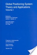
The Global Positioning System: Theory and Applications, by Parkinson and Spilker.
The Global Positioning System: Theory and Applications,
by Dr. Bradford Parkinson and Dr. James Spilker
1996, American Institute of Aeronautics and Astronautics
ISBN 978-1-56347-106-3
This exhaustive two-volume compendium of GPS knowledge is my daily bible for almost any GPS technical query you can muster. The two volumes total 781 pages and, truth be told, they are certainly doorstops, and while they are essential to your encyclopedic knowledge of GPS, they are certainly not to be carried around as textbooks. They are reference books, and the kind that should remain in your library at home. I treat my copies very gingerly, since they are about to fall apart from constant use. Plus, both volumes are signed by both editors, since they are both close friends and colleagues — but that is not why I recommend them. If Dr. Bradford Parkinson is the father of GPS, then Dr. James Spilker is the father of the GPS frequency and signal structure. Both Brad and Jim are currently Professors Emeritus at Stanford University and we visit on a regular basis, but again, friendship does not enter into my recommending these volumes.
I recommend them because they are simply the best compiled and edited volumes on GPS that exist today. They are authoritative and technical to a fault. As I said before, the word exhaustive comes to mind, and frankly, I don’t know how any GPS aficionado or SME could make it through the day without these incredible reference tools. I know from first-hand knowledge that both Brad and Jim have been approached about an updated edition, but I don’t know how they would find the time. They are both in great demand and are constantly writing and speaking about GPS in venues around the globe. But it would be wonderful if they could fit it in. Now a digital, searchable version — that would be something.
Guide to Super Snipers, Soldier of Fortune Magazine, edited by Brown and Spencer.
Guide to Super Snipers, Soldier of Fortune Magazine,
edited by Lt. Col. Robert K. Brown and Vann Spencer
2013, Skyhorse Publishing
ISBN 978-1-62636-067-9
This book is an edited history of snipers and their equipment that in the last 15 years has included GPS and other PNT systems on a consistent basis. Soldier of Fortune magazine and the editors interviewed literally hundreds of snipers around the world, and this is their story. Some of the snipers made headlines, like Audi Murphy, and were popular American heroes. Others you will have never heard of, but that does not make them any less meaningful or important in the roles they have played keeping their country safe.
This book includes great details about legacy and current sniper rifles and the expert marksmen behind the scopes and sights. It may be more than you ever wanted to know about the art and science of snipers, but it is an inspiring and patriotic book that many will thoroughly enjoy. Be aware there are numerous typographical and grammatical errors — try not to let that impair your enjoyment of this one-of-a-kind book.
Until next time, visit the RNTF site, support eLORAN, read a good book, and I wish you happy navigating.