The forum brings together experts from industry and regulatory authorities to discuss the future of network and spectrum monitoring in increasingly complex RF environments.
The forum will provide a full day of insights, technical exchange, and hands-on demonstrations. Rohde & Schwarz and its partners will present keynote addresses and expert presentations, and provide networking opportunities with professionals from across the network and spectrum monitoring ecosystem. Participants also can consult directly with Rohde & Schwarz technology specialists.
The European Navigation Conference (ENC) series is widely acknowledged as the most important annual event in Europe bringing together the full positioning, navigation and timing (PNT) community.
ENC 2026 will take place in Vienna, Austria, from April 28-30, 2026. This follows very successful ENCs in the last few years.
ENC2026 offers:
a technical program across three days with up to four parallel sessions,
daily keynote addresses in plenary, bringing the community together,
a friendly and collaborative atmosphere, with opportunities to meet exhibitors and fellow delegates, including informally over drinks and dinner as part of the conference social programme,
an environment to gain insights, grow social networks and foster new collaborations.
The ENC-series is a collaboration across the European Group of Institutes of Navigation (EUGIN), with the Austrian Institute of Navigation (OVN) leading ENC 2026 at the Austria Center Vienna.
The conference will highlight the latest advancements in PNT. The broad technical program will include all related aspects of technology, science, systems and applications.
ENC-series is open to everyone from industry, academia, government and user segments. To learn more, visit the ENC 2026 website.
Geoinformation has evolved from a specialist tool to an essential resource for government, business and civilian use. Whether captured from space or drones, analyzed through artificial intelligence (AI) or 3D visualizations, geographic data now, more than ever, drives critical decisions across industries.
INTERGEO 2025 exemplifies this transformation. From Oct. 7-9, the Frankfurt Exhibition Center will host the world’s leading conference and trade show for geodesy, geoinformation and land management, featuring more than 500 international exhibitors ranging from innovative startups to industry giants.
Three-Day Conference Program Features 100 Sessions The INTERGEO Conference will present approximately 100 presentations and sessions over three days, drawing speakers from space agencies, United Nations organizations, government ministries and international technology companies.
Key topics include AI-powered remote sensing, urban digital twins, open data strategies, Earth observation for climate and crisis management and building information modeling (BIM) integration for infrastructure lifecycle management.
Keynote presentations such as “Earth Observation and Artificial Intelligence” and “Cartography for the Future” will provide forward-looking insights, while panel discussions on digital sovereignty and standardization will address strategic frameworks. Each session demonstrates how geoinformation serves as the critical foundation for climate adaptation, disaster preparedness, urban development and infrastructure protection.
Opening Day Features Space Technology Focus
DVW President Prof. Rudolf Staiger will open INTERGEO on Tuesday, Oct. 7, followed by a keynote from Johann Dietrich Wörner, space coordinator for the state of Hesse. His presentation, “Earth Observation and Artificial Intelligence,” will explore how AI transforms massive Earth observation datasets into actionable insights for climate, agriculture and urban planning projects.
Prof. Serena Coetzee of UNU-FLORES will deliver the German Cartography Congress keynote on Wednesday, Oct. 8, addressing cartography’s evolution amid growing geodata volumes and governance challenges.
Thursday morning’s panel discussion, “Digital Transformation – Perspectives, Trends and Theses,” will examine the need for reorienting geoinformation management to foster innovation and collaboration.
Revolutionizing Geospatial Data Analysis
AI is accelerating the transformation of raw data into actionable insights, fundamentally changing how professionals work with geoinformation. The session “AI-Based Analysis of Remote Sensing Data for Updating the ATKIS Basic DLM” demonstrates practical applications in public administration.
The Hessian Administration for Soil Management and Geoinformation uses AI methods to automatically detect landscape changes, significantly improving the quality and timeliness of digital landscape models.
Urban digital twins are rapidly advancing from static models to powerful operational platforms. The session “From Data to Insights: Visualization Technologies for Next-Generation Digital Twins” will showcase how modern visualization makes complex systems accessible and accelerates planning processes.
The research project “DigitalCities4Us” illustrates practical applications, using high-resolution 3D data to enable barrier-free urban planning and improve accessibility for people with mobility restrictions.
Additional sessions will examine implementation across administrative levels. “The Digital Twin NRW: A Practical Report” presents a statewide geospatial data infrastructure that is freely accessible and continuously developed. The city of Zurich will demonstrate its transition from traditional geospatial data infrastructures to multifunctional twin platforms.
Geodata infrastructures, open data and data spaces form the backbone of digital transformation and serve as key prerequisites for digital sovereignty. Multiple sessions will emphasize the importance of stable, future-ready geodata infrastructure.
Standardization receives particular attention through presentations like “Three Perspectives, One Goal: Digital Sovereignty through Open Standards in BIM and GIS” and the position paper “Official Geodata as a Basis for Digital Processes in Planning, Construction and Operation.” These sessions demonstrate how uniform standards for data exchange between geographic information systems and building information modeling can accelerate planning, construction and operational processes.
The position paper represents a joint initiative of buildingSMART Germany, the Working Committee of the Surveying Authorities and the Federal Association of Publicly Appointed Surveyors.
Critical infrastructures require precise, reliable data to minimize risks. The presentation “Regional and Effective Flood Protection in the State Capital of Düsseldorf” demonstrates how geoportals and flood forecasting tools prevent flooding and strengthen urban infrastructure resilience.
Bringing Innovation to the Exhibition Floor
Registration is now open at the INTERGEO website. The INTERGEO 2025 team looks forward to welcoming attendees to the Frankfurt Exhibition Center from Oct. 7-9.
The future of positioning, navigation and timing (PNT) technology takes center stage this month at ION GNSS+ 2025, running Sept. 8-12 at the Hilton Baltimore Inner Harbor.
The Institute of Navigation’s flagship conference has evolved beyond its original focus to embrace all PNT technologies that complement satellite navigation — a shift GPS World readers will recognize, as we expanded our coverage in the same direction years ago.
This year’s program tackles evolving topics including low-Earth orbit (LEO) satellites for PNT, resilient navigation in satellite-denied environments, autonomous systems and lunar navigation. International researchers will present hundreds of technical papers while exhibitors demonstrate breakthrough technologies and services.
GPS World staff will be on-site throughout the event, connecting with readers, contributors and industry partners while gathering insights on emerging developments. Click here to follow along with our coverage.
Government, industry and public safety leaders call for action on PNT resiliency as threats escalate.
GPS is the invisible backbone of modern life, supporting America’s national and economic security in ways both recognized and overlooked. While other countries have developed competing systems, GPS remains far ahead of its rivals. Yet that dominance is also a vulnerability. GPS is a single point of failure, and the U.S. lacks complementary positioning, navigation and timing (PNT) solutions. A successful disruption could cost the U.S. economy $1.6 billion per day and impact everything from first responders to our energy grids.
As threats to GPS reliability mount, policymakers and industry leaders gathered on Capitol Hill to underscore the urgent need for backup systems to protect America’s PNT infrastructure.
Last month, I hosted an event on Capitol Hill called: “The Race to GPS Resiliency: What the US Can Do Today to Strengthen National Security.” It brought together senior officials from the Department of Defense (DOD), the Federal Communications Commission (FCC), Congress and industry to make the case for a layered approach to PNT resiliency. These experts examined the technical vulnerabilities of GPS, the increasing frequency of jamming and spoofing incidents, and the policy measures required to expedite the deployment of complementary technologies.
GPS: Foundational and Fragile
The first panel focused on how federal agencies are addressing growing vulnerabilities in GPS. Thomas Rondeau, Ph.D., principal director for FutureG at DOD, shared some eye-opening insights, including how a DARPA project demonstrated that, for less than $300 in parts from Amazon, one could “create a very bad day for the American military.” He called GPS disruption one of the easiest threats to develop and warned that adversaries are already exploiting this vulnerability as part of modern conflict.
From left to right: Diego Areas Munhoz, reporter, Punchbowl; Thomas Rondeau, Ph.D., principal director for FutureG, DOD; Arpan Sura, senior counsel, chief AI officer, FCC.
Rondeau shared how GPS disruption is now a feature of modern warfare, as he witnessed firsthand during his time at DARPA: “We were seeing massive loss of capabilities, and ordnance, because they were dependent on GPS. And as soon as they flew there, the tent turns on, capability goes away, we lose… assets.”
Arpan Sura, senior counsel and chief AI officer at the FCC, walked through the FCC’s process for evaluating GPS alternatives and discussed how the agency is considering complementary PNT technologies.
“National security is one of his (Chairman Carr’s) top priorities. And we recognize, as Tom mentioned, that GPS remains vulnerable to jamming and spoofing. But also, non-national security threats like solar flares, environmental risks like orbital debris. And there is heavy reliance on it in the U.S. economy,” Mr. Sura said.
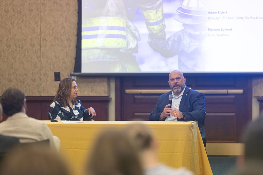
Lives on the Line
From left to right: Mariam Sorond, board chair and CEO, NextNav; Adam Eldert, director of public safety for Fairfax County, Virginia.
During the second panel, the conversation shifted from global conflict zones to local communities. Adam Eldert, director of public safety for Fairfax County, Virginia, emphasized the life-saving value of resilient PNT technologies in emergency response.
“Technology should be carrying us forward, allowing us to make better decisions with the information we have to affect life-saving measures faster, get to places quicker and avoid any sort of potential problems,” said Eldert.
Mariam Sorond, CEO and president of NextNav, pointed out that GPS limitations can delay locating 911 callers and responding to active threats like a mass shooting situation she and Eldert had previously discussed. “It’s not just to save somebody’s life, but it’s also about preventing disasters.”
She then highlighted the company’s 5G-powered 3D terrestrial PNT solution, which is currently being considered by the FCC’s ongoing Notice of Inquiry on PNT and in a separate Petition for Rulemaking specific to NextNav. She explained that the company is working to address a national security challenge with a near-term, future-proof solution that delivers a widescale terrestrial PNT solution without relying on taxpayer funding.
Congressional Support
The closing panel featured Rep. Richard Hudson (R-NC), Chairman of the House Energy & Commerce Subcommittee on Communications and Technology, and former Rep. Greg Walden (R-OR), who previously chaired the full committee.
Both Hudson and Walden warned that the United States is lagging behind adversaries such as China and Russia in deploying terrestrial backup systems to GPS.
Chairman Hudson reflected on how the issue hits close to home: “I represent Fort Bragg, the largest army base in the world. We call it the epicenter of the universe. Our special forces and airborne troops that deploy out of Fort Bragg rely on GPS for almost everything they do. So, real-life scenarios with them keep me awake at night.”
Chairman Walden spoke about another high-profile case in San Diego. “[T]here was a naval exercise between two ships, and they jammed GPS… which caused some issues, ” said Walden. “It also speaks to the problem we have, in America, where, unlike China and Russia, two of our adversaries, they have terrestrial-based systems for GPS backup.”
What Comes Next
The event made clear that action is needed — and possible. Mr. Sura told the crowd that he believes the FCC’s Notice of Inquiry will help drive a conversation about a holistic approach to PNT resiliency, exploring the economics of how these systems will work, and how to foster competition in a way that will yield multiple outcomes. When asked about next steps, Mr. Sura encouraged the group to “stay tuned.”
Speakers throughout the event called for continued public-private collaboration to accelerate development of a more resilient PNT system — one that combines space-based and terrestrial technologies to safeguard national security, critical infrastructure, and public safety.
Congressman Hudson closed with a note of urgency and optimism: “It’s clear the FCC understands the urgency, and they’re conducting thorough reviews right now.”
Diane Rinaldo of Peake Advisors, which sponsored the event, is one of the country’s leading authorities on 5G, telecommunications supply chain security and privacy. She served as Acting Administrator of the National Telecommunications and Information Administration and Acting Assistant Secretary of Commerce for Communications and Information in the first Trump Administration.
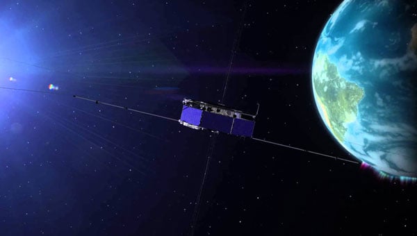
The 39th Annual Small Satellite Conference (colloquially referred to as SmallSat) takes place Aug. 10-13, 2025, at the Salt Palace Convention Center in Salt Lake City.
SmallSat will bring together 4,000 participants from 1,300 organizations and 45 countries, along with 400 exhibitions, to explore all aspects of small satellites — from breakthrough missions and capabilities to launch services and student research. It is the world’s largest gathering devoted to small satellite innovation, exploration and impact.
Keynote speaker Nicola “Nicky” Fox, NASA’s Associate Administrator for the Science Mission Directorate, will speak on Monday, Aug. 10, at 10 a.m. in the Grand Ballroom of the Salt Palace.
The National Association of State Aviation Officials provides opportunities for those engaged in aviation and unmanned aerial vehicles.
NASAO’s Annual Convention & Trade Show provides a space for state aviation directors and their staff to connect, collaborate, and become inspired. Not only does the annual convention provide hundreds of attendees with engaging sessions and demonstrations, it also gives them the chance to experience the state like a local.
The 2025 conference will take place in Grand Forks, North Dakota, Sept. 21-24, at the Dena’ina Civic and Convention Center.
GPS World staff will be attending XPONENTIAL 2025, taking place May 19–22 at the George R. Brown Convention Center in Houston, Texas. The event is co-hosted by the Association for Uncrewed Vehicle Systems International (AUVSI) and Messe Düsseldorf North America (MDNA). Organizers expect participation from thousands of professionals representing defense, commercial and public sectors, amid ongoing changes in federal investment and policy related to autonomous technologies.
Keynote Speakers and Programming
The conference will feature keynote addresses from leaders in government, industry and academia.
Speakers include:
Chris Rocheleau, acting administrator of the Federal Aviation Administration
Lt. Gen. Francis L. Donovan, vice commander of U.S. Special Operations Command
Sue Gordon, former principal deputy director of National Intelligence
Matt Ocko, co-founder of DCVC
Jim VandeHei, co-founder and CEO of Axios
Maj. Gen. Michelle Link, commanding general of the 75th Innovation Command, U.S. Army Reserve
Ryan Tseng, CEO and co-founder of Shield AI.
These speakers are expected to address topics ranging from national security to advancements in logistics and the deployment of autonomous systems worldwide.
Educational Sessions and Industry Trends
XPONENTIAL 2025 will offer more than 150 sessions led by more than 400 experts, covering topics such as infrastructure readiness, advanced research and development, artificial intelligence integration, cybersecurity, and regulatory trends. The educational program is designed to address the rapid growth and evolving policy landscape in robotics and autonomous systems.
Defense-Focused Programming
The event includes AUVSI Defense, a dedicated track examining the integration of uncrewed and autonomous technologies in military and national security applications. Scheduled sessions include the U.S.-Taiwan Autonomous Systems Cooperation Forum, a SOCOM Townhall on special operations and a panel on defense technology trends observed on the Ukraine battlefield.
Exhibition Hall
Attendees will have opportunities for hands-on demonstrations with equipment such as drones, electric vertical takeoff and landing aircraft (eVTOLs), uncrewed vehicles and robotic platforms. XPONENTIAL 2025 is positioned as a major annual gathering for stakeholders in the uncrewed systems industry, offering a platform for collaboration, education and technology demonstration.
TDK Corp. recently revealed that its subsidiary, Tronics Microsystems, will exhibit at the Offshore Technology Conference 2025 from May 5-8. The event will take place at NRG Park in Houston, Texas, and will feature a wide range of solutions for the future of offshore energy.
Tronics will showcase its high-performance MEMS inertial sensors and a high-temperature MEMS accelerometer for inclination measurement in directional drilling applications. The company recently unveiled the AXO314, its latest addition to the Tronics AXO300 accelerometer platform. This digital MEMS accelerometer is designed for industrial applications operating under shock and vibration, with a ±14 g input range.
Leveraging a strong track record in serving demanding aerospace and railway markets, Tronics will demonstrate how its closed-loop sensor’s architecture assists drilling guidance tools to operate under high temperature, vibrations and shock conditions.
Attendees can attend a live demo of a miniature north-seeking MEMS gyroscope, enabling precise azimuth measurement in downhole survey tools, according to the company.
The Federal Communications Commission (FCC) has issued a Notice of Inquiry (NOI) seeking public input on positioning, navigation and timing (PNT) systems and policies. While GPS is crucial for the United States’ economic and national security, its dependency as a single point of failure renders it vulnerable to disruption or manipulation by adversaries. Recognizing this vulnerability, leaders such as President Trump, Chairman Cruz, and Senator Markey have advocated for developing alternative systems to ensure resilient PNT capabilities.
PNT data is integral to countless military, public safety, agricultural, and commercial activities. Given the dependence of the American economy and national security on GPS as the sole PNT source, the agency states that the U.S. government is prioritizing efforts to create robust backup systems that can safeguard essential functions in the event of GPS signal disruptions.
The FCC’s NOI examines how the agency can foster the development of alternative and complementary PNT. It seeks feedback on various emerging PNT technologies being developed by broadcasters, wireless operators, satellite constellations and startups utilizing FCC-licensed spectrum. The inquiry also addresses tradeoffs among these technologies based on performance, scalability, geographic coverage, durability, cost and commercialization potential.
The Commission aims to establish a comprehensive record to guide its actions in enhancing GPS resilience and promoting alternative PNT solutions. Potential measures include regulatory changes, public-private partnerships, testbeds, Innovation Zones and other initiatives.
Two PNT-related petitions are currently under FCC consideration. NextNav has proposed allocating approximately $5 billion worth of spectrum to collaborate with telecom providers in establishing a PNT network. Meanwhile, the National Association of Broadcasters (NAB) has suggested adopting a new TV signal format capable of transmitting PNT information without requesting additional spectrum allocation. Insights from the NOI will help inform decisions on these proposals.
The FCC’s inquiry reflects growing concerns about reliance on GPS as a single system for PNT data. By fostering alternatives like terrestrial networks or broadcast-based solutions such as NAB’s Broadcast Positioning System, the Commission seeks to strengthen national resilience against potential disruptions to critical infrastructure and services.
Federal Communications Commission (FCC) Chair, Brendan Carr announced in a March 5 blog post that the commission would be addressing GPS alternatives along with Next Generation 911 issues at its next meeting.
Pledging that “…public safety and national security will be top priorities for us at the FCC” along with quick action on related issues, Chairman Carr said the commission’s March 2025 open meeting will start “… with an inquiry that explores alternatives to GPS.”
Describing GPS as indispensable but not infallible, Carr’s post showed a substantial appreciation of PNT and GPS alternative issues as well as much of the related policy history.
It also cites President Trump, Senator Cruz, and Senator Markey as advocating action to “… ensure we have a resilient system in place.”
In 2020, President Trump issued Executive Order 13905 on “Strengthening National Resilience Through Responsible Use of Positioning, Navigation, and Timing Services.” Designed to stimulate adoption of open market commercial solutions, it does not seem to have made the nation’s PNT substantially more resilient in the intervening five years. This may be because GPS is free and time and navigation have been provided by the government as free utilities for hundreds of years. Also, many GPS users may be unsure about the need for alternatives since the federal government has not yet acted to protect itself with an alternative system. Potential users are also reluctant to purchase commercial PNT services as they are unsure which commercial services will have the longevity to make the cost and effort of adoption and integration worthwhile.
President Trump also supported the need for GPS alternatives in Space Policy Directive 7, “The United States Space-Based Positioning, Navigation, and Timing Policy.” It called for the government to “…identify and implement, as appropriate, alternative sources of PNT for critical infrastructure, key resources, and mission-essential functions.” This directive was issued shortly before the end of the first Trump administration and, though the directive still stands, this provision has not yet been acted upon.
Carr’s mention of Senators Cruz and Markey undoubtedly refers to their joint sponsorship of the National Timing Resilience and Security Act of 2018. The act called for the Department of Transportation to ensure establishment of at least one terrestrial timing system as a backup for GPS signals. The first Trump administration and the Biden administration never requested funding for such an effort, so the mandate has yet to be implemented.
An FCC meeting on GPS alternatives is also timely as the commission has received two petitions related to provision of nation-wide PNT services. One is from NextNav, seeking spectrum to underwrite its proposal to work with telecom providers. The other is from the National Association of Broadcasters (NAB), asking to mandate and accelerate implementation of the new ATSC 3.0 television broadcast format. NAB says its Broadcast Positioning System signals will be included as part of that format.
While GPS alternatives will be discussed at the upcoming meeting, no decisions on systems is contemplated. Carr says the commission:
“… will vote on an inquiry to explore other Positioning, Navigation, and Timing (PNT) systems that can be complements or alternatives to GPS. Beyond answering technical questions, we hope this effort will engage stakeholders across government and industry to encourage the development of new PNT technologies and solutions.”
Discuss current PNT technologies and efforts, both from governmental and private sector entities, for developing complementary and resilient PNT technologies.
Seek comment on various space-based solutions for resiliency of PNT, such as medium Earth orbit (MEO) satellite systems and low Earth orbit (LEO) satellite systems.
Seek comment on various terrestrial solutions for resiliency of PNT, such as leveraging TV broadcast infrastructure, ground-based transmitters, and/or user equipment positioning.
For all technologies, ask commenters for information on the benefits and challenges of particular PNT technologies or solutions based on factors such as: geographic coverage; availability of existing equipment; use of spectrum resources; the extent to which the technology should be viewed as a complement to or substitute for GPS and other PNT technologies; performance characteristics such as range and precision; durability; international considerations; and the cost and incentives to develop, deploy, and maintain the technology or solution.
Seek comment on additional actions that the Commission could take to facilitate the security of PNT technologies available to consumers.
Seek comment on whether to amend the Commission’s existing rules or adopt new rules to promote adoption of complementary and alternative PNT technologies.
Ask questions about what role public-private partnerships, testbeds, or Innovation Zones may play to test and develop PNT technologies.
The FCC open meeting’s agenda also includes two items about 911 services. One of those is “Strengthening 911 Location Accuracy Rules” especially for the vertical (z) axis. This seems to be a separate and distinct issue from the PNT agenda item with the burden of performance and response placed on telecom providers. That said, some eventual linkage cannot be entirely discounted.
The meeting will take place on March 27 from 10:30 to 12:30 EDT. A formal agenda will be posted approximately a week in advance. The meeting can be live streamed at https://www.fcc.gov/March2025 and a recording will be available on YouTube shortly thereafter.
The Federal Aviation Administration (FAA) has partnered with the Naval Air Warfare Center Aircraft Division (NAWCAD) to initiate steps toward approving Controlled Reception Pattern Antennas (CPRAs) for use in aircraft. This collaboration addresses GPS/GNSS jamming and spoofing threats, with the current focus on a Request for Information (RFI) to study anti-jamming and anti-spoofing technologies. The RFI, published on SAM.gov, aims to identify and evaluate vendors’ antenna technologies for potential integration into civilian aircraft.
CPRAs could significantly mitigate terrestrial-based GPS/GNSS jamming and spoofing, enhancing aviation safety by preserving situational awareness and reducing pilot workload during disruptions. The technology’s effectiveness in neutralizing ground-based threats positions it as a critical tool for maintaining reliable navigation systems.
RFI details and next steps
NAWCAD is leading the RFI process, which includes hosting industry days and establishing Cooperative Research and Development Agreements for testing hardware and evaluating performance. Responses to the RFI are due by May 26, 2025, at 5:00 PM EST, with questions accepted until April 25, 2025. Data from the RFI and subsequent testing will inform updated Minimum Operational Performance Standards for GPS/GNSS antennas and cockpit displays.
Dana Goward, president of the Resilient Navigation and Timing Foundation, noted that this is a great first step, but cautioned that widespread adoption of CPRAs in commercial aircraft will take a long time due to the lengthy FAA approval and certification processes, along with the significant financial investment and effort required to install CRPAs in airplanes.
Although CPRAs address terrestrial threats, space jamming continues to be a critical concern. Adversaries often outpace countermeasures, necessitating continuous innovation to keep up with advancing threats.
FAA safety alert highlights risks
The FAA issued Safety Alert for Operations (SAFO) 24002 on Jan. 1, 2024, to alert operators and manufacturers about the risks of GPS/GNSS disruptions. The alert emphasized the potential for increased pilot workload and safety risks due to situational awareness loss during jamming or spoofing incidents.
On Jan. 17, 2025, the State Department proposed removing CPRAs from the U.S. Munitions List (USML), shifting their regulation to the Commerce Department’s Export Administration Regulations (EAR). This change, effective Sept. 15, 2025, aligns CRPA export controls with other dual-use technologies, streamlining their adoption. A 60-day public comment period is open via regulations.gov.