Another pair of Galileo navigation satellites is scheduled for launch by Soyuz rocket in May, ahead of a quartet on an Ariane 5 in the autumn, bringing the Galileo system a step closer to operational use.
The European Commission asked ESA to look into the feasibility of a Soyuz launch in the first half of the year to speed up the deployment of the constellation and to increase its robustness for delivering initial services.
One satellite is in storage at ESA’s technical centre in the Netherlands, having completed all its testing to clear it for flight, with another due to join it very soon.
The satellite platforms are built by OHB in Bremen, Germany, with their navigation payloads coming from Surrey Satellite Technology Ltd in the UK, using a steady stream of high-technology equipment sourced from all across Europe.
Once through testing, the satellites are flown to Europe’s Spaceport in French Guiana, to be launched two at a time on Soyuz rockets.
Cutaway view of the Soyuz rocket fairing carrying a pair of Galileo satellites, seen atop the Fregat upper stage that flies them most of the way to their intended medium-altitude orbit. (ESA illustration)
A total of 12 satellites has been deployed into orbit during the last four years — six in the last year alone.
The Galileo production line has attained a steady rhythm, as has the environmental testing, so six satellites are available for launch this year, more than were initially planned.
In the second half of the year, four satellites will be launched together for the very first time, on a customized “Ariane 5 ES Galileo.”
In development since 2012, it is based on the Ariane 5 ES (Evolution Storable), previously used to place ESA’s 20-tonne ATV vehicle into low orbit for resupplying the International Space Station.
This new variant will carry a lighter payload — four fueled 738 kg Galileo satellites plus their supporting dispenser — but will take it up to the much higher altitude around 23 222 km.
The target orbit is actually 300 km below the Galileo constellation’s final working altitude. This leaves Ariane’s upper stage in a stable ‘graveyard orbit’, while the four satellites maneuver themselves up to their operating position.
Following this first Ariane 5 flight, there should be 18 Galileo satellites in orbit.
Europe’s ninth and tenth Galileo satellites have started broadcasting working navigation messages. The two satellites were launched together on Sept. 11, 2015.
Once safely in orbit and their systems activated, their navigation payloads and search and rescue transponders were subjected to a rigorous process of in-orbit testing, to ensure their performance reached the necessary specifications to become part of the Galileo system.
Radio-frequency measurements of the Galileo signals were made from ESA’s Redu centre in Belgium. The site boasts a 20 m-diameter dish to analyze their signal shape in high resolution.
Along with assessing that the satellites themselves were functioning as planned, the test campaign also confirmed they could mesh properly with the worldwide Galileo ground network.
The testing was coordinated from the Galileo Control Centres in Oberpfaffenhofen in Germany – performing the command and control of the satellites — and Fucino in Italy — overseeing the provision of navigation messages to users.
An artist’s depiction of four Galileo satellites sending navigation signals. (ESA)
“This is the first recurrent launch of Galileo Full Operational Capability satellites from an in-orbit test point of view,” comments Christian Lezy, supervising the measurement campaign in Redu.
“All tests were conducted in a seamless manner in parallel with the ongoing routine operations of the rest of the fleet.”
The operations team, successfully led by SpaceOpal GmbH, completed the testing campaign few days ahead of schedule, with the satellites beginning to broadcast valid navigation signals on Jan. 29.
The following two Galileos — satellites 11 and 12, launched on Dec. 17, 2015 — are undergoing their own in-orbit test campaign. Once their initial Launch and Early Operations Phase was completed at the Toulouse facility of France’s CNES space agency, both spacecraft were handed over to the Oberpfaffenhofen centre during the Christmas period.
Platform commissioning and drift stop and fine positioning maneuvers have also been completed, placing both satellites into their final working orbits, while their payload activation is proceeding according to schedule.
Galileo satellites 13 and 14 have completed all pre-flight testing at ESA’s ESTEC test centre in Noordwijk, the Netherlands, and have been put into storage ahead of their launch. Production of the remaining 12 satellites is continuing around the clock at OHB’s facility in Bremen, Germany.
The complete Galileo constellation will be made up of 24 satellites across three orbital planes, with two ‘active spare’ satellites per orbital plane, ready to plug any gap in service should an operational Galileo malfunction.
At the moment the satellites are transmitting navigation signals for technical validation purposes, being employed by Galileo engineers as well as the rest of the satnav industry to prepare Galileo-compatible products and services.
Ten years ago saw the launch of Europe’s very first navigation satellite. A decade of hard work later, more than a third of the Galileo constellation has followed it into orbit and a ground network sharpening the satnav system’s accuracy encompasses the globe.
Galileo’s GIOVE-A retired in June 2012. (Photo: ESA)
GIOVE-A, short for Galileo In-Orbit Validation Element-A, was launched by Soyuz from Baikonur cosmodrome in Kazakhstan on Dec. 28, 2005.
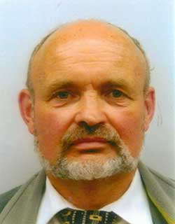
“Much work had already taken place on the ground, but GIOVE-A marked the first time that Galileo hardware went into orbit,” recalls Didier Faivre, heading ESA’s navigation directorate.
“It had a crucial role: to claim operating frequencies that had been set aside for Galileo by the International Telecommunications Union, to demonstrate essential technologies such as Galileo’s rubidium atomic clock, and to gather data on the radiation-rich environment of medium-altitude orbit, which was a relatively unknown region for Europe.
Didier Faivre (Photo: ESA)
“So GIOVE-A opened the way to all that followed — the follow-up GIOVE-B in 2008, and then the launches of the Galileo satellites proper — a total of six double-satellite launches from 2011 to earlier this month, with 12 satellites placed in orbit so far, on the way to the full 30-satellite constellation.
“Our three launches this year doubled the number of satellites in orbit, and the pace of progress is set to increase further in 2016, when we will see Ariane 5 called on to launch Galileo for the first time, doubling the number of satellites released on each flight.”
Progress in space has been mirrored on Earth, with the establishment of Galileo’s ground segment: two control centers in Fucino, Italy, and Oberpfaffenhofen, Germany, sit at the heart of a worldwide network of ground stations.
The Soyuz launcher carrying GIOVE-A climbs into the sky above Kazakhstan on Dec. 28, 2005. (Photo: ESA)
This ground segment, as one of the most complex infrastructures ever overseen by ESA, has the task of keeping all the satellites healthy and their navigation signals synched — the timing system accurate to a few billionths of a second that provides the submetre precision.
Sensor stations to monitor Galileo signals and return data to the control centers are required all across the vast footprint of the system. Their locations range from the Arctic to Antarctic to lonely mid-ocean islands, all connected back to Europe via satellite.
Initial Galileo services are set to be available during next year. New generations of commercial satnav receivers are already Galileo-ready, having received extensive technical checks from ESA’s Navigation Laboratory.
GIOVE-A in a clean room at ESA’s ESTEC technical centre in the Netherlands, having instrumentation sensors installed in advance of testing in 2005. (Photo: ESA)
And national governments are already preparing to make use of Galileo’s Public Regulated Service — PRS, the most secure and precise class of service, restricted to authorized users. Belgium, France, Italy and the UK have all performed their own PRS acquisitions and positioning testing.
As for GIOVE-A, the satellite that started it all, its ESA mission concluded in 2012, once the first four Galileo satellites followed it to orbit. Remarkably, it is still operational, controlled by builder Surrey Satellite Technology Ltd in the UK.
In the past it has carried out tests of high-altitude satnav detection. Its radiation monitor continues monitoring the medium-altitude orbit environment, helping to forecast the future long-term performance of its Galileo descendants.
Just what every satnav engineer wanted for the holidays: a new Interface Control Document to unwrap under the tree. On Nov. 30, the European Commission (EC) published version 1.2 of the Galileo Open Service Signal In Space Interface Control Document (OS SIS ICD v1.2). The document provides the information for receiver and chipset manufacturers, application developers and service providers to process and make use of the open signals generated by the Galileo satellites. This most recent iteration incorporates feedback from receiver manufacturers and other stakeholders.
The Galileo OS SIS ICD v1.2 specifies:
Galileo signal characteristics.
Characteristics of Galileo spreading codes.
Galileo message structure.
Message data contents.
Key new features in version 1.2 include:
An annex with numerical examples of FEC coding and interleaving.
A revised and simplified license agreement.
Cross-reference to a companion document, “Ionospheric Correction Algorithm for Galileo Single Frequency Users,” containing details on the ionospheric model used for Galileo.
In addition, a number of minor editorial improvements including corrections and clarifications have been made.
The Galileo OS SIS ICD v1.2 document can be downloaded here.
The Ionospheric Correction Algorithm for Galileo Single Frequency Users document can be downloaded here.
Twelve Birds for December
Also timely for end-of-year celebrations, Galileo satellites 11 and 12 lifted off together on Dec. 17 atop a Soyuz rocket, and successfully deployed in space four hours later. The pair effectively doubles the number of Galileo satellites in space over the last nine months.
Five satellites are now set operational to the user. Once 9 and 10 (launched in September 2015) as well as 11 and 12 are set operational, a total of nine usable satellites will be in orbit. Satellites 5 and 6 may be partially usable at some point.
“Along with the ground stations put in place around the globe, this brings Galileo’s completion within reach,” said Jan Woerner, director general of the European Space Agency.
“Production, testing and launch of the remaining satellites are now proceeding on a steady basis according to plan,” added Didier Faivre, ESA’s director of Galileo and navigation-related activities.
Starting with launches in the third quarter of 2016, four satellites at a time will rise into orbit on all except one date, which remains at two. This accelerated deployment should bring 30 satellites on line — 24 operational and six orbit spares — by 2020 for full operational capability of the European GNSS. Initial operating capability is foreseen by the end of 2016.
Service Centre and Help Desk
The European GNSS Agency (GSA), responsible for Galileo service provision as directed by the EC, is developing the European GNSS Service Centre (GSC), which provides the single interface for information and help to users of the Galileo Open Service (OS). The GSC will eventually operate on a 24/7 basis and offer a range of services, including hosting the Galileo User Helpdesk, providing the interfaces between the Galileo System and OS users and hosting a centre of expertise for OS service aspects.
Question: What is the optimum number of GNSS signals to include/process in a consumer-grade PNT device?
Philip Mattos Receiver Designer Consultant
A: A chip should support four signals, being GPS/GLONASS/Galileo/Beidou, but only process two of them — choice depending on region, geopolitical sensitivity, constellation availability — dropping to one to save power when satellite availability is good. Two constellations give enough satellites for accuracy and availability in obstructed environments. Which two depends on needs regarding cost, power and so on, GPS and Galileo being better in the future for less power, but GPS and GLONASS being better today.
Greg Turetzky
Principal Engineer
Intel
A: The receiver should be capable of processing sufficient signals to provide optimum performance in all expected use cases. This means it should be able to support all GNSS and augmentation systems to provide maximum robustness to blockages and interference. The management of receiver resources to accomplish that is highly dynamic on individual epochs and should be invisible to the user in consumer-grade devices. Optimizing tradeoff between performance, power and cost is where the secret sauce lies.
Ruslan Budnik CEO SPIRIT Navigation
A: Two constellations give reliable, fast cold start even after long overseas flights. There is room for improvement in challenging conditions, so application of three constellations is the saturation point. Choose the best combination in different parts of the globe. In Russia that should be GLONASS + 2, in China BeiDou + 2, in Europe Galileo plus two, GPS + QZSS + another one in Japan, and so on. Navigation chipmakers should support all operating satnav systems to offer the best combination, taking into account battery drain.
Jeremie Godet, Galileo Implementation Head of Sector, European Commission (left); Fiammetta Diani, deputy head of Market Development, European GNSS Agency.
By Jérémie Godet and Fiammetta Diani
The Galileo programme is currently in its deployment phase, which is due for completion in 2020. Following declaration of initial services in 2016, an exploitation phase will start and aim at delivering a fully operational system by the end of 2020. The deployment and the exploitation are entirely financed through the budget of the European Union, while two non-EU members, Norway and Switzerland, contribute through international agreements.
The aim of the Galileo programme is to establish and operate the first global satellite navigation system under the control of the European Union, thus contributing, amongst other things, to the strategic autonomy of the Union. This is the first time that the EU has developed, owned and been responsible for such a large-scale infrastructure.
While independence is the main political objective, ensuring compatibility and interoperability with other existing and future systems is also critical. Indeed, frequency compatibility has been achieved with GPS, IRNSS, QZSS and COMPASS with a range of coordinations achieved in the last two years under the framework of the International Telecommunication Union (ITU). A wider international agreement was previously reached in 2004 between the U.S and the EU, achieving the compatibility and interoperability of their respective systems and resulting in a common modulation for both systems’ state-of-the-art open signals. A positive outcome of this for all GNSS users is that similar signals have been adopted by other global or regional systems, in particular the MBOC modulation jointly defined by the U.S. and the EU (Galileo, GPS, COMPASS, QZSS), the ALTBOC modulation adopted by COMPASS and a common signal in E6 adopted by QZSS.
The Galileo programme will provide unique services, functionalities and performance levels that have never, or not yet, been provided by other satellites navigation providers.
What Will Users Get, and When?
These services, defined in consultation with user communities and EU Member States, will be offered by the system:
An Open Service (OS): With positioning accurate to around 1 meter using up to three different frequencies (E5a, E5b and L1), free of charge to the user and providing positioning and synchronization information intended mainly for high-volume satellite navigation applications;
A Public Regulated Service (PRS): Restricted to government-authorized users, for sensitive applications which require a high level of service continuity. It will use strong encrypted signals. This service is intended for security-related use for the EU Member States, the European Council, the European Commission, the European External Action Service and duly authorized Union agencies. It may be accessed by non-EU states and international organizations subject to bilateral agreements.
A contribution to the Search and Rescue Service (SAR) of the COSPAS-SARSAT system: Galileo’s worldwide search-and-rescue service will help to forward distress signals to a rescue coordination center by detecting emergency signals from beacons and relaying messages to them in near real time.
A contribution to integrity monitoring services by means of Galileo OS signals, in cooperation with other satellite navigation systems, aimed at users of safety-of-life applications in compliance with international standards;
A Commercial Service (CS): Encrypted for authentication purposes and offering very high accuracy to the sub-decimeter level, it will target applications for professional or commercial use owing to improved performance and data with greater added value than that obtained through the open service.
As of 2016, Galileo will progressively offer initial services for the open service, search-and-rescue service and the public regulated service. Those initial services will be gradually improved, and the other two services will be gradually implemented, with the aim of reaching full operational capability by end 2020.
The performance improvements of the services expected between 2016 and 2020 are linked to completion of the constellation deployment. In 2018, this will reach 24 satellites, the number required to achieve Galileo’s positioning performance targets, and the completed constellation with up to 30 satellites will be in place by the end of 2020 to provide the necessary spares to ensure performance commitments.
On top of this, a number of additional capabilities are planned to be added to the core services, including:
An improvement of the OS nav message with full backward compatibility to enhance both the time-to-first-fix and the ability to perform signal acquisition and tracking for users in lower visibility conditions (INAV improvement);
An authentication of the OS navigation message allowing users to verify that a certain number of broadcast parameters are the actual Galileo data — aimed at applications requiring trusted position and timing information for commercial purposes;
An improvement of the PRS;
A new functionality within SAR that provides, via the navigation message, a Return Link Message to distress beacons acknowledging that a rescue center has received their distress signal.
Constellation Status
The current Galileo constellation is composed of two different families of satellites: the In-Orbit-Validation (IOV) satellites procured before 2010 and the Full-Operational-Capability (FOC) satellites procured after 2010. Since the last Galileo launch on Sept. 10, there are four IOV satellites and six FOC satellites in orbit. The FOC satellites have improved capabilities regarding signal transmission compared to the IOV satellites, despite a similar mass and size. The FOC satellites carry a SAR payload; two IOV satellites have this capability. While this initial deployment faced a number of difficulties, these are now well behind us.
Sixteen more FOC satellites are being built. The next launch of two FOC satellites is scheduled for Dec. 17, and four more launches (three Ariane 5 and one Soyuz) are foreseen from 2016 to mid-2018. This implies four to six satellites launched per year, and this is judged perfectly realistic as demonstrated already in 2015.
An additional series of satellites will be procured in 2016 for deployment starting in late 2019/early 2020.
Preparing to Use and Benefit
The ultimate objective of the Galileo program is for its signals to be translated into valuable and reliable services for users across the globe. Europe aims to generate the return on investments in terms of public benefits for citizens and businesses, and for this reason the users are at center of the program.
This is the focus of the European GNSS Agency (GSA), which is in constant dialog with user communities via a wide range of activities.
For example, cooperation with chipset and receiver manufacturers aims to ensure that all products are Galileo-ready. This process involved a successful testing campaign done in cooperation with ESA and the EC’s Joint Research Centre (JRC). Equally important is to work closely with large user communities, such as road, maritime and rail, to support them in updating their systems so that they are ready to use Galileo. This is accomplished by dedicated market and technical support, via cost-benefit analyses, testing campaigns, initiation of standards and certification processes, user satisfaction surveys and more. These actions are part of tailored adoption roadmaps built with each user community. Periodic user fora are also organised to get feedback on current services and collect ideas for the evolution of the European GNSS systems.
EU R&D programmes, such as Horizon 2020 for the development of Galileo applications as well as the recently launched Fundamental Elements program that focuses on funding European GNSS chipset and receiver technologies, are essential tools for preparing users and supporting EU competitiveness in the downstream sector.
The GSA leverages these EU R&D programmes as a tool for adoption with large user communities and receiver manufacturers fully involved. The projects are managed by experienced staff specialised in different markets and application areas. In the case of PRS, the core user equipment technology is being designed and tested. This work is already paying off; today, a growing number of receivers available on the global market are Galileo-enabled, while almost 70 percent of the models have EGNOS.
Among others, Europe’s ST Microelectronics in the automotive sector, and the U.S.’s Broadcom and the Taiwanese Mediatek in smartphones, have already announced their Galileo-ready chipsets. Many other chipset manufacturers are ready and tested for Galileo. It is expected that, with recent successful launches and the deployment schedule, most of them will bring their Galileo products to market in 2016.
Galileo on the Horizon
Despite its particularly challenging complexity, involving extensive technical and security requirements, Galileo deployment is now progressing well and services will be provided starting in 2016, to reach their full operational capability in 2020. One early benefit of interoperability with GPS is that even before the Galileo constellation is completed, the number of L5/E5a signals in space will allow meaningful use of that frequency for the first time. Galileo will deliver real advances in precision, availability, coverage and additional features unprecedented in any other satellite navigation systems to date: while GPS is today’s de facto standard, Galileo is aiming to be the world’s second GNSS reference system by 2020.
Governance Set-up
The European Commission (EC) has overall programme supervision and budget responsibilities. The EC delegates system design and infrastructure procurement to the European Space Agency (ESA) and service preparation, delivery and operations to the European GNSS Agency (GSA). ESA is one of founders of the Galileo system and has been responsible for the development phase, co-financed by the Member States of ESA and the EU. ESA is the procurement agent of core infrastructure and in charge of the overall system integration since 2007.
The GSA’s role will grow considerably in the exploitation phase as it becomes the day-to-day interface with ESA in several areas, including infrastructure roll-out and maintenance. The GSA will procure main operations of the system from 2017 and will operate key services facilities such as the Galileo Security Monitoring Centre in France and the UK, the European GNSS Service Centre in Spain, and the Galileo Reference Centre in the Netherlands. The GSA also supports the enabling of receivers and chipsets for Galileo use and the development of applications in downstream segments, in close cooperation with the major user communities.
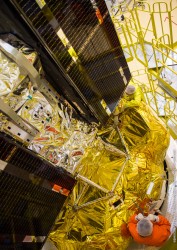
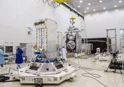
Galileo satellites 11 and 12 are mated with their dispenser. (Photo: ESA)
News from the European Space Agency
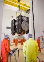
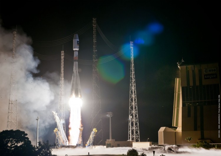
Galileos 11 and 12 are on the launch pad, attached to the top of their Soyuz rocket in readiness for this week’s launch. Europe’s next navigation satellites are due for launch at 11:51 GMT (12:51 CET, 08:51 local time) on Thursday, Dec. 17, from Europe’s Spaceport in French Guiana.
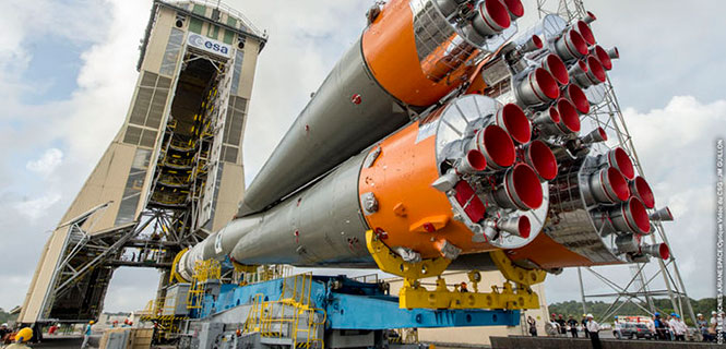
On Dec. 10, the two satellites, already attached to their carrier, were fixed to the Fregat upper stage before the halves of the protective Soyuz fairing were closed around them on Friday. This marked the completion of the ‘upper composite’ — the combination of Galileo satellites, dispenser and the upper stage that will fly them the bulk of the way up to their medium-altitude orbit.
Meanwhile, the first three stages of the Soyuz were assembled horizontally, rolled out to the pad, and raised to the vertical. The upper composite was moved to the pad on Sunday afternoon, hoisted to the top of the tower and then then carefully attached to Soyuz.
The Dec. 14 Launch Readiness Review opened the way to Soyuz fueling and finally launch.
Galileos 11 and 12 are on the launch pad, attached to the top of their Soyuz rocket in readiness for this week’s launch. (Photo: ESA)
This latest Galileo campaign began with the arrival of the satellites in French Guiana on Oct. 30. This is the sixth Galileo launch overall, and the third launch of 2015, and will bring the number of Galileo satellites in space to 12. It takes place just 11 days before the 10th anniversary of the liftoff of Europe’s very first navigation satellite.
The experimental GIOVE-A took off on Dec. 28, 2005, to reserve operational frequencies, test key hardware and gather data on the orbital environment for the Galileo constellation to follow. GIOVE-B followed in April 2008.
Since then, not only has the first third of the Galileo constellation reached orbit, but a network of Galileo ground stations has been erected across the globe.
In future, the number of satellites that can be inserted into orbit with a single launch will double from two to four, when a customized Ariane 5 rocket becomes available to complement Soyuz.
We have grown accustomed to seeing market projections for some GNSS, notably Galileo. European GNSS Agency economists have done a remarkable job analyzing and predicting the global market over the past five years. Business intelligence firms in the U.S. periodically report on the power of GPS driving, or participating in, significant portions of the U.S. economy. Figures from Russia are scant but do occasionally emerge, even if they are difficult to integrate into a meaningful global picture.
Now the Global Navigation Satellite System and Location-based Services Association of China (GLAC) has issued a report asserting some lofty, often staggering, and occasionally surprising statistics and projections.
China’s satnav system is helping generate $31.3 billion for the country this year. That benefit is expected to double in five years.
70 percent of China’s population uses smartphones. That’s 980 million people who may be sending location requests at any given time. This constitutes the biggest growth sector found by the GLAC.
China’s installed base of navigation devices in private vehicles lags behind the United States, at less than 500,000, or 5 percent of cars, but 20 percent of 1 million commercial vehicles in China use products that access BeiDou technology.
“Sky’s the Limit for BeiDou’s Clients,” crowed China Daily. Meanwhile, halfway round the world in Prague, the Czech Republic, Jing Li of the China Transport Telecommunication & Information Center, reported to a conference of the International Association of Institutes of Navigation that a BeiDou global service will be provided by 2020. The National Differential BeiDou Ground-Based Augmentation System will have 175 reference stations, with more than 1,000 network stations and a space-based augmentation system to boot. So far, the system has hit every benchmark.
Some market projection figures strike one as wildly optimistic, while others have proved true. Some GNSS appear to grow or modernize in fits and starts. But BeiDou appears steadily ascendant.
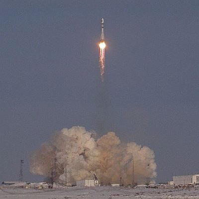
Galileo satellites 11 and 12 will be launched atop of the legendary Soyuz rocket on Dec. 17 from Europe’s Spaceport in French Guiana. Ten years after the launch of GIOVE A, on Dec. 28, 2005, Galileo is now a reality.
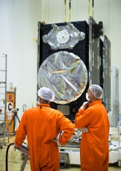
Having completed their rigorous checks in space, two more of Europe’s Galileo satellites are now fully operational, broadcasting navigation signals and relaying search and rescue messages from across the globe.
Galileo 7 and 8 were launched on March 27 from Europe’s Spaceport in French Guiana. Once the satellites were nursed to life in orbit, their navigation payloads underwent a lengthy test campaign.
This involved assessing that the satellites themselves were performing as planned and meshing with the worldwide Galileo ground network.
Galileo’s 20-m IOT L-band antenna is the largest dish at ESA’s Redu ground station.
The satellites’ secondary search and rescue payloads were also put to the test, picking up and relaying UHF signals from distress beacons as part of the international Cospas–Sarsat system.
Radio-frequency measurements were made from ESA’s Redu centre in Belgium. The site boasts a 20 m-diameter dish to analyse Galileo signals in great detail. Last but not least, security testing has ensured that Galileo’s Public Regulated Service – a maximum precision service restricted to authorised users – is as secure as required.
“These latest two operational Galileos are the third and the fourth Full Operational Capability satellites,” said David Sanchez-Cabezudo, ESA’s Galileo In-Orbit Test Manager.
“These are the versions that will make up the bulk of the Galileo constellation in space, with 16 satellites still to be launched.
“The checks carried out from the Galileo Control Centres in Oberpfaffenhofen in Germany and Fucino in Italy, as well as from Redu, prove the performance of these two satellites is excellent for navigation purposes.
“New onboard features such as seamlessly swapping between the different atomic clocks – a unique feature in global satnav systems – has been verified, which translates into more robust navigation services.”
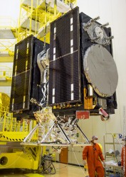
Liftoff of Soyuz ST-B flight VS11 carrying Galileo satellites 7 and 8, March 27 at 22:46 GMT, from Europe’s Spaceport in French Guiana.
The first pair of full satellites was placed in incorrect orbits in 2014 by a malfunction of their Soyuz launcher’s upper stage, but the elongated orbits have since been modified so that the navigation payloads can perform as planned. The European Commission is set to make a decision on whether they will be employed as part of the Galileo constellation.
The second pair, launched in March, was inserted into the correct orbits. September’s third pair, also in the correct orbits and undergoing payload testing, should enter service early next year.
The latest twins have arrived in French Guiana, aiming for a Soyuz launch on Dec. 17. The intention is to have those satellites ready to enter the operational constellation by next spring.
China’s new third-generation BeiDou satellites are broadcasting some new signals in space. The newest signal, which just began broadcasting from a satellite launched on Sept. 30, is similar to the future GPS L1C signal with time-division BOC(1,1) and BOC(6,1) signals. Such a type of modulation is called time-multiplexed binary offset carrier (TMBOC).
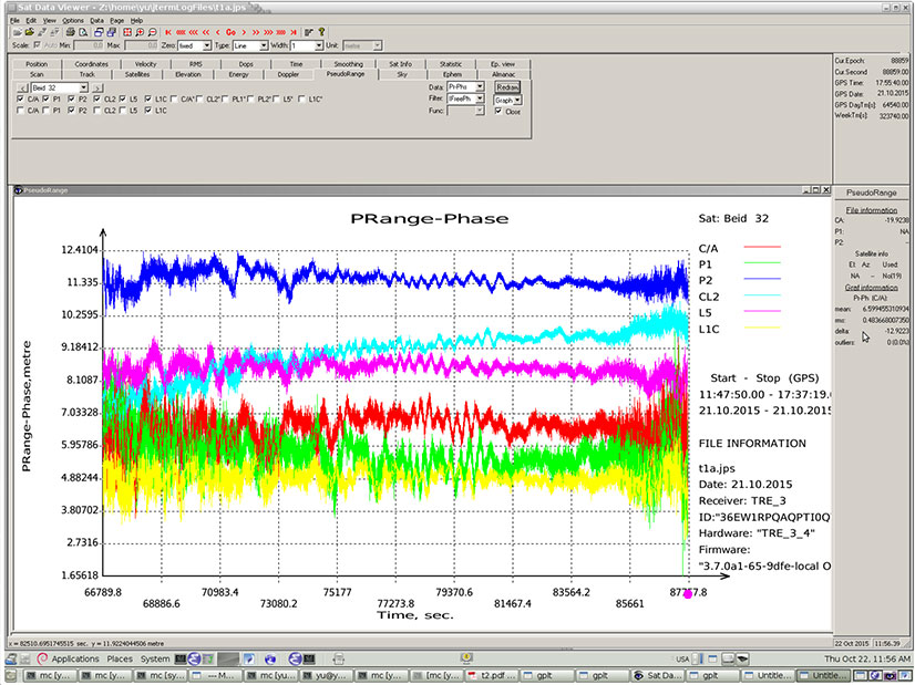
Researchers at JAVAD GNSS have been tracking the new signals, particularly those from BeiDou-3 I2S, an inclined geosynchronous orbit (IGSO) spacecraft, NORAD number 40938. I2S is transmitting on three frequency bands.
The JAVAD researchers used the decoding approach described in their February 2013 GPS World article, “Signal Decoding with Conventional Receiver and Antenna: A Case History Using the New Galileo E6-B/C Signal” by Sergei Yudanov. As a result, the signal’s structure was decoded and L1C TMBOC tracking has been successfully tested on the JAVAD GNSS TRE-3 receiver.
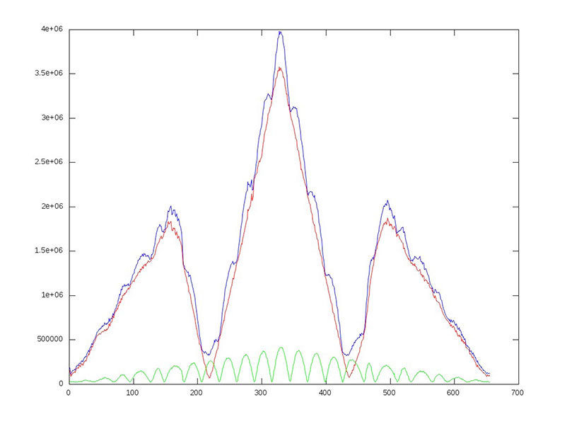
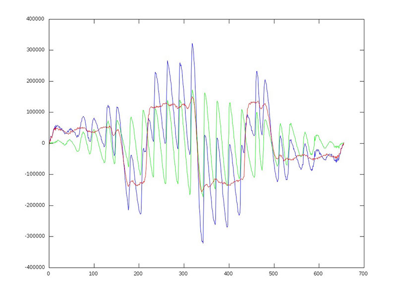
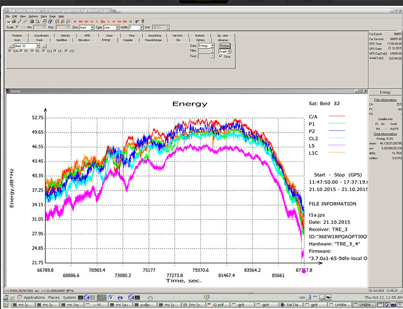
In addition, new signals on 1575.42+1.023*14 MHz (B1-2), 1176.45 MHz (E5A) and 1207.14 (E5B) frequencies for three satellites (PRN 32, 33, 34) also have been decoded and tested. Figures 1–4 illustrate the experiment.
Figure 1: BeiDou TMBOC: correlation intensity (l) of BOC(1,1) (red), BOC(6,1) (green) and their sum (blue) versus code chips.Figure 2: BeiDou TMBOC: Output of “early-late” correlator (dI or derivative of I) of BOC(1,1) (red), BOC(6,1) (green) and their sum (blue) versus code chips.Figure 3: BeiDou TMBOC Signal: Horizontal axis: 0 – minus one chip shift; 327 – zero shift; 655 – plus one chip shift. C/NO and iono-free “range minus phase.” Slot – BeiDou signal: C/A – B1; P1 – B1-2; P2 – E5B; L2C – B3; L5 – E5A; L1C – L1C.Figure 4 (right): BeiDou TMBOC Signal: Horizontal axis: 0 – minus one chip shift; 327 – zero shift; 655 – plus one chip shift. C/NO and iono-free “range minus phase.” Slot – BeiDou signal: C/A – B1; P1 – B1-2; P2 – E5B; L2C – B3; L5 – E5A; L1C – L1C.
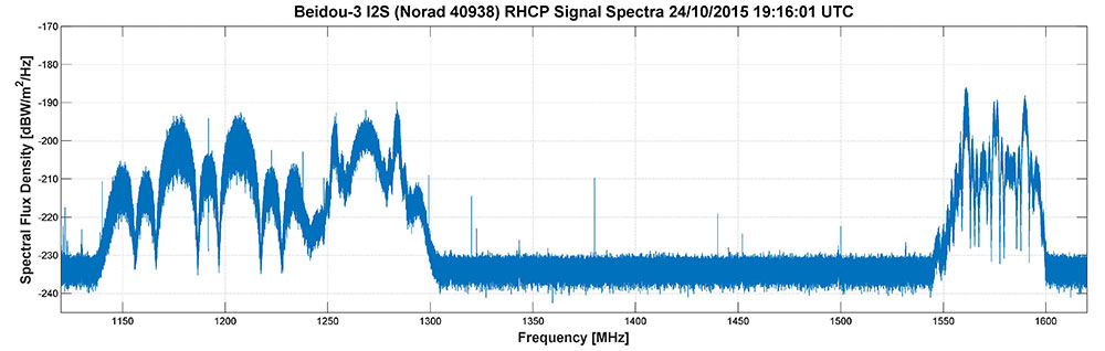
Researchers Steffen Thoelert and Michael Meurer from the Deutsches Zentrum für Luf t- und Raumfahrt (DLR, German Aerospace Center) have also been busy tracking the newest BeiDou IGSO satellite. Figure 5 shows a spectral measurement of the complete GNSS L-band frequency range, which shows the signal transmissions on B1, B2 and B3 band. The signal was captured with DLR’s high-gain antenna in Weilheim, operated by the DLR German Space Operations Center in Oberpfaffenhofen.
Figure 5: BeiDou Signal: Complete GNSS L-band frequency range, which shows the signal transmissions on B1, B2 and B3 band.
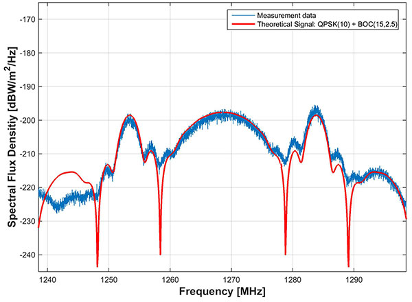
In comparison to the two latest BeiDou-3 MEO satellites, launched on July 25, the IGSO has an additional signal on the B3 band. The MEO satellites transmit only the QPSK(10) whilethe new IGSO also transmits an additional BOC(15,2.5) signal. Figure 6 shows the B3 frequency band separately including a combined theoretical signal (QPSK(10)+BOC(15,2.5)).
Figure 6: BeiDou Signal: the B3 frequency band separately include a combined theoretical signal PSK(10)+BOC(15,2.5)).
IIF-11 up: penultimate GPS Block IIF satellite
A United Launch Alliance Atlas V 401 launched the GPS IIF-11 mission for the U.S. Air Force on Oct. 31.
GPS IIF-11 is the second to last of the Block IIF satellites, delivering a second civil signal (L2C) for dual-frequency equipment, and a new third civil signal (L5) to support commercial aviation and safety-of-life applications. The next generation of GPS satellites is GPS III.
GPS IIF-11 is the third GPS mission to rise this year. GPS IIF-9 launched in March, and GPS IIF-10 in July. The next satellite, GPS-IIF-12, the last of its generation, is destined for space in early February 2016.
Galileos chirp
Shortly after the Galileo satellite using the E24 PRN code started transmitting on Oct. 10, its sibling began transmitting using code E30. Several stations participating in the International GNSS Service Multi-GNSS Experiment are tracking the new satellites; first among those reporting was the University of Liege, Belgium, using its Septentrio PolaRx4 and PolaRxS receivers to download signals.
The two satellites were launched on Sept. 11. A team of engineers from ESA and France’s CNES space agency are preparing for the next launch, scheduled for December.
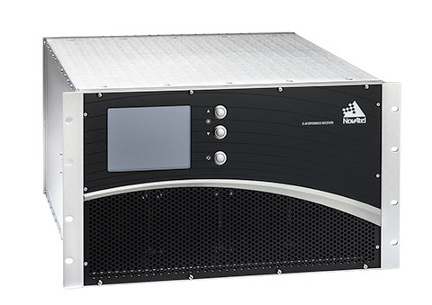
The U.S. Federal Aviation Administration (FAA) and NovAtel have exercised a bilateral option to produce a Wide Area Augmentation System (WAAS) G-III—Galileo prototype receiver. Maintaining core NovAtel WAAS G-III functionality for GPS and SBAS signal processing, the new receiver will operate in the WAAS reference station test environment to facilitate research on multiple GNSS constellation utilization.
The prototype receiver will also add functionality to support tracking and demodulating associated navigation data for Galileo satellites including:
Galileo E1 and E5a tracking
Ephemeris and almanac reporting/processing from E1 or E5a
Automatic channel assignments
Time solution computed from Galileo
Correlator information for signal deformation on Galileo signals
The WAAS G-III—Galileo prototype receiver will be developed on NovAtel’s existing WAAS G-III receiver hardware and application software, and delivered as a field-loadable firmware package. The WAAS G-III—Galileo receiver will not be qualified to DO-178B Level D as part of this contract.
NovAtel’s WAAS G-III reference receiver platform was designed with expandability and multi-GNSS SBAS evolution in mind, and can be customized to meet the needs of individual satellite networks. NovAtel has already delivered G-III based reference receivers to several programs worldwide, including the WAAS G-III receiver (US WAAS, FAA), IRIMS G-III receiver (India IRNSS, ISRO), and QZSS G-III receiver (Japan QZSS, NEC) variants.
The company’s reference receivers and uplink station equipment have been a central element of the U.S. WAAS since its inception. The WAAS third-generation reference receiver (G-III) uses fully updated hardware, and tracks all GPS signals including the legacy GPS L1 C/A, L2P(Y) (semi-codeless), and the modernized L2C, L5, L1C signals as well as the WAAS L1 C/A and L5 signals.
The WAAS G-III reference receiver provides a rich set of range measurement data, signal integrity metrics, and logs for processing by the system’s data communication processor, NovAtel said. The WAAS G-III – Galileo prototype receiver is the first G-III platform evolution for the FAA, an important step towards possible GPS + Galileo dual-GNSS SBAS operations in the future.