Galileo, BeiDou, QZSS, IRNSS, and more join GPS and GLONASS to bring you wider, broader, greater, more accessible and above all more accurate PNT. How to get all that’s coming at you?
Multi-GNSS paves the way for complete exploitation of new signals and constellations in navigation, surveying, geodesy and remote sensing.
The free 1-hour webinar, which will take place at 1 p.m. Eastern [10 a.m. Pacific, 7 p.m. (1900h) Central European Time] on Thursday, Sept. 20, will review advantages of using multi-GNSS for the end-user and challenges in obtaining maximum efficiency when combining multiple constellations and signals. It will also discuss different approaches of testing GNSS receivers against jamming and spoofing attacks.
You will learn:
Advantages of using multi-GNSS
Challenges when combining multiple constellations
Robustness of multi-GNSS receivers to jamming and spoofing
Test solutions for GNSS receivers.
The webinar presents sponsored content by Skydel and Talen-X. Register for it here.
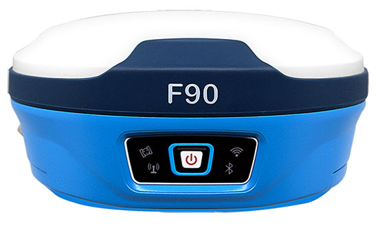
Geneq Inc. has released the F90, a multi-constellation GNSS receiver with a high level of technology integration. The new product is designed to fulfill surveyors’ demands for performance, flexibility and cost-effectiveness.
The F90 tracks multiple constellations (GPS, GLONASS, Galileo and Beidou) and can maximize the acquisition and tracking process with all-in-view GNSS satellite frequencies, the company said.
Providing maximum performance for accuracy and real-time measurements, the F90 also supports real-time kinematic correction services, including the RTX service that can achieve centimeter accuracy without a base station.
The F90’s advanced technology ensures a high performance even in harsh environment such as under heavy canopy, Geneq said.
The F90 has an excellent combination of GNSS, 4G, Bluetooth and Wi-Fi antenna. With highly integrated Bluetooth, Wi-Fi and 4G network modules, and without affecting accuracy and efficiency, the innovative F90 GNSS receiver is light and small. Even with its magnesium-alloy casing, F90 weighs only 1 kilogram and measures 140 x 157 x 76 millimeters.
With its integrated highly sensitive E-bubble and new tilt survey algorithm, the F90 becomes a calibration-free GNSS receiver, Geneq said. It is immune to magnetic disturbance and free from the limitation of tilt angles so that it can be used to measure inaccessible points.
Equipped with an internal radio, enabling frequency band change from 410 to 470 MHz, the F90 can be used with different radio communication protocols. Another important feature is its integrated second-generation web user interfae control, which is fully compatible with all devices and all browsers.
The user will benefit the F90’s two smart hot swappable Lithium batteries (the same battery used with Geneq’s SXPad 1000P data collector), allowing uninterrupted field work for up to 10 hours.
NovAtel Inc. has launched its TerraStar-C PRO correction service with multi-constellation support, including the GPS, GLONASS, Galileo and BeiDou constellations.
Combined with NovAtel’s OEM7 positioning technology, TerraStar-C PRO cuts initial convergence times by nearly 60 percent and offers 40 percent better horizontal accuracy than the current TerraStar-C service, the company said.
NovAtel’s TerraStar-C PRO offers a robust multi-constellation solution that provides greater positioning accuracy, availability and reliability than before, the company added. With the growing number of operational GNSS satellites, TerraStar-C PRO offers benefits in challenging signal conditions such as multipath, shading, interference and scintillation. High-rate TerraStar-C PRO corrections provide reconvergence in less than 60 seconds following brief GNSS signal interruptions.
According to NovAtel, TerraStar-C PRO corrections are generated using TerraStar’s proprietary global network of more than 100 strategically located GNSS reference stations. The correction data is delivered worldwide through overlapping geostationary satellites directly to a NovAtel receiver or via cellular IP network.
With OEM7 triple L-band support, TerraStar-C PRO correction signals from up to three satellites can be tracked and used simultaneously, providing continuous correction data reception when the primary satellite signal is blocked.
“TerraStar-C PRO enables higher operational efficiency by allowing users to start operations sooner and continue to work through challenging conditions without interruptions,” said Sara Masterson, NovAtel’s positioning services segment manager. “We continue to build our TerraStar portfolio of services and with the addition of TerraStar-C PRO customers can trust that they have not only a highly-reliable precise positioning solution, but also services that immediately translate to increased productivity.”
TerraStar-C PRO is available immediately as a termed subscription service for agriculture, unmanned, airborne and land applications, such as survey, mapping and GIS and supported on compatible OEM7 products with firmware version 7.05 and later.
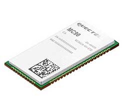
According to the company, the module supports hybrid positioning technologies including GNSS, Cell ID and Wi-Fi aided positioning, and enables position tracking in both indoor and outdoor environments.
Quectel’s MC90 integrates the multi-GNSS system, including GPS, GLONASS, Galileo and QZSS, which makes it suitable for urban areas with high-rise buildings and complex environments, the company added.
The MC90 also adopts Wi-Fi hotspot positioning technology for blind spots and satellite coverage. It integrates multi-aiding positioning technologies to offer customers with optimized GNSS performance. It also supports EPO technology, which provides predicted Extended Prediction Orbit to speed up TTFF without the need of any extra server.
The MC90 features a compact design, low power consumption and supports dual SIM single standby function. According to Quectel, it can be used for a wide range of internet of things applications, including bicycle sharing, student ID card, vehicle tracker, wearable device, pet tracker, asset tracker, driving recorder and more.
The Trimble Catalyst software-defined GNSS receiver for Android phones and tablets has been updated to support GLONASS. The update demonstrates the advantages of software GNSS for delivering new functionality faster and easier, according to Trimble.
Access to the GLONASS constellation increases the number of GNSS satellites visible when working in the field. As a result, it improves the ability to maintain lock on enough satellites to keep working when sky visibility is limited or obstructed, such as under tree canopy and in urban high-rise environments, Trimble said. Users also spend less time waiting for the receiver to achieve an accurate position, and convergence time is faster and more reliable.
Trimble Catalyst provides users with positioning-as-a-service to collect highly accurate location data with Trimble or third-party apps on Android smartphones and tablets. When combined with a small, lightweight, plug-and-play DA1 digital antenna and Catalyst subscription, the receiver provides on-demand GNSS positioning capabilities, and transforms consumer devices into centimeter-accurate mobile data collection systems.
“Adding GLONASS to Trimble Catalyst provides productivity improvements and more robust positioning for Catalyst users,” said Gareth Gibson, Catalyst business development manager at Trimble. “In addition, since the service is provided via an Android app, performance updates are available through the Google Play store. As a user, receiving updates is easy and automatic.”
Another GLONASS-M satellite was launched on June 17 from Plesetsk Cosmodrome.
A Fregat booster carried satellite GLONASS-M 59 to its designated orbit, the Russian Defense Ministry said in a statement on Sunday, as reported by Russian News Agency TASS.
“The Soyuz 2.1-b carrier rocket, launched at 00:46 Moscow time from the Plesetsk space center (Arkhangelsk Region), put the Russian GLONASS-M navigational satellite into the designated orbit at the scheduled time,” the statement read.
Ground-based facilities of the Titov Main Test and Space Systems Control Centre of the Russian Space Forces have assumed control of the satellite.
Telemetry communication with the spacecraft is stable and the onboard systems function normally.
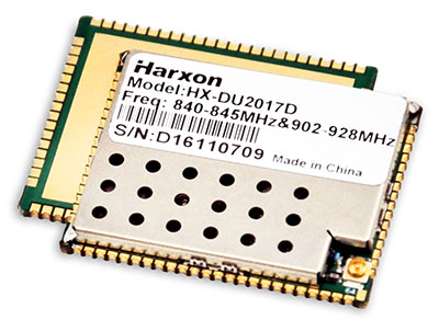
Harxon showcased high-precision positioning GNSS antennas and its latest wireless data-transmission technologies for UAV applications at AUVSI Xponential, which was held April 30-May 4 in Denver.
The Harxon D-Helix Antenna.
Harxon’s D-Helix is a patented D-QHA (dual-quadrifilar helix antenna) multi-constellation antenna supports excellent reception of GPS, Galileo, BeiDou and GLONASS, as well as L-band signals. Harxon D-QHA technology ensures the ability of low elevation satellites tracking while maintaining 4-dBi high gain, which makes the D-Helix antenna an excellent choice for any applications where the sky is partially visible, the company said.
The antenna’s low noise amplifier (LNA) with out-of-band rejection performance can suppress electromagnetic interference. Moreover, the D-Helix features the latest low wind resistance design with ruggedized IP67 protection for UAV inspection and monitoring, survey and mapping or agricultural UAVs.
Photo: Harxon
The HX-DU2017D is a 5-gram frequency-hopping OEM transceiver supporting frequencies between 840 MHz and 900 MHz. It provides strong anti-jamming and signal receiving capability for complex data intensive applications. Its full duplex mode ensures data secure transmission, more stable long-range communication and short latency of data transmission.
Watch this video to learn more about the HX-DU2017D.
Other showcased Harxon GNSS products, such as Helix Antenna HX-CH7603A, HX-CH4601A and HX-CH6601A, are all featured with patented D-QHA technology. Moreover, the showcased Survey Antenna GPS 500, OEM Modem HX-DU1018D and Smart Antenna are also appropriate for surveying and mapping, as well as precision agriculture.
Contrary to the “Out in Front” editorial published in the April issue of GPS World magazine, there was an Izvestia story published on March 28 touting the possibility of a merger of the GLONASS and BeiDou systems, and there will be an International Conference on Advanced Technologies in Manufacturing and Materials Engineering in Harbin, China, at which such a possibility may hypothetically be discussed.
However, neither hard news nor any official statements have emerged to substantiate such a dubious claim, despite repeated queries to officials of both countries.
Javad Ashjaee (far left, above), CEO of JAVAD GNSS and based in Moscow, communicated that he spoke on a panel at an aerospace technology event organized by the American Chamber of Commerce in Russia, alongside representatives from NASA, Boeing, Honeywell and Roskosmos.
Ashjaee asked the Roskosmos official publicly about the prospect of a GLONASS merger with BeiDou, and “he knew nothing.”
On April 26, the U.S. Department of Transportation publicly released the long-awaited GPS Adjacent Band Compatibility Assessment. See the June issue of GPS World for an expert and measured analysis of this highly impactful document.
The article will be posted online when it becomes available in mid-to-late May.
Merger Mystery
Contrary to the “Out in Front” editorial published in the April issue of GPS World magazine, there was an Izvestia story published on March 28 touting a merger of the GLONASS and BeiDou systems, and there will be an International Conference on Advanced Technologies in Manufacturing and Materials Engineering in Harbin, China, at which such a possibility may hypothetically be discussed.
However, neither hard news nor any official statements have emerged to substantiate such a dubious claim, despite repeated queries to officials of both countries.
Javad Ashjaee (far left, above), CEO of JAVAD GNSS and based in Moscow, communicated that he spoke on a panel at an aerospace technology event organized by the American Chamber of Commerce in Russia, alongside representatives from NASA, Boeing, Honeywell and Roskosmos.
Ashjaee asked the Roskosmos official publicly about the prospect of a GLONASS merger with BeiDou, and “he knew nothing.”
Diverger Dilemma
As this magazine goes to press, stories emerge of a U.K. plan to launch a satellite-navigation system separate from the European Union’s Galileo project. This comes in response to an EU statement that the UK would be shut out of key elements of the European satnav program, particularly the Public Regulated Service, after Brexit.
Historically, in the late 1980s or early 90s the UK drew up plans for its own GNSS prior to the launch of Galileo. And UK-based Surrey Satellite Technology Ltd. built all operational Galileo payloads to date. So the country clearly has the capability. That SSTL is currently owned by Airbus (either German or Dutch division) may or may not constitute a wrinkle.
Finally, the UK spent 1.4 billion euros on Galileo, and may now file for a refund.
The Long Life of GPS III
By Robin Wrinn, Contributing Author
GPS III SV01 in electromagnetic interference, compatibility and passive intermodulation testing. (Photo: Lockheed Martin)
During interviews with Lockheed Martin and Harris Corporation at the 34th Space Symposium, time and space were a frequent focus of discussion, but not in the normal “continuum” kind of way.
Greater mission longevity is one of the key improvements GPS III delivers over those currently in service. Space Vehicles 1–10 have a planned mission life of about 15 years, 25 percent longer than their predecessors. Yet that begs the question “How long should a satellite live in space, with technology innovation occurring almost annually?”
Advanced payload technology provides a partial answer to that question. Both Lockheed Martin and Harris Corporation highlighted new payload capabilities with built-in flexibility to adapt satellites in orbit to technology advances, as well as changes in missions.
Lockheed Martin provided the media a tour of their Radio Frequency Payload Center of Excellence. Meanwhile, Harris recently announced completion of the fully digital Mission Data Unit (MDU), core to the navigation payload for GPS III 11 +. As a reminder, the current Harris payload for SVs 1–10 includes:
greater than three times reduction in range error,
up to eight times increase in anti-jamming power,
added signals, including L1C, compatible with other GNSS such as Galileo, and
greater signal integrity.
According to Harris, the fully digital navigation payload will provide the ability to change and upgrade the satellites incrementally over mission life.
Meanwhile, Lockheed announced a partnership with NEC to introduce artificial intelligence for computer learning in orbit. The company’s Payload Center experts touted significant advances in processers and a move toward next-generation antennas, arrays and transmitters to drive more satellite flexibility, capability and resilience.
Observation: The market pressures of ‘new space’ players is prompting delivery of products that can drive more value for less cost. In this case, delivery of a common payload architecture and electronically steered beams to make satellite antennas become any shape you want. Most likely, beams of a different size on demand is a much better business case than a static one built five years ago.
The day I interviewed Lockheed Martin’s Navigation Systems mission area Program Manager Johnathon Caldwell, the company had submitted its proposal for the U.S. Air Force’s GPS III Follow On (GPS IIIF) program. That same day, April 16, the media was given a tour of Lockheed Martin’s GPS III satellite assembly floor. It was clear from both Lockheed’s press materials and Caldwell that Lockheed Martin believes it is fully recovered from prior production hiccups and is
on track to deliver GPS Space Vehicles (SVs) 1 through 10, and
deserves to win the bid for GPS IIIF. Now that both Boeing and Northrop Grumman have dropped out of the running, Lockheed is virtually assured the contract. The government has said it will announce the award in March 2019.
What are the differences in the GPS III satellite payloads that were instituted to enable the new signals?
The main difference is the power. The Air Force’s requirements called for significantly more anti-jamming capability. All the transmitters are a higher power.
What was the most significant obstacle (or top obstacles, plural) in designing and manufacturing this new payload, to new Air Force specifications? How did you overcome it/them?
Same answer really, the higher power. Keeping in mind, we went from a 7-year mission life requirement to a 15 year. That higher power puts more strain on components and new cyber requirements in software. When you couple all that together we are not just upgrading payload technology. It is really engineering a new set of payload requirements. It’s new generation, advanced.
What are the advantages of a digital payload over the alternative?
The advantages and the 30 percent difference are the timekeeping system portion. We’re moving from a manual, analog timing to digital to deliver to the Air Force more flexibility. It’s a nice option to have to be able to reprogram in orbit and maybe enhance capabilities desired in the future.
with Johnathon Caldwell, Navigation Systems Mission Area Program Manager
Any changes in your production approach having completed SV01?
No, the performance on Vehicle 01 was as designed there were no technical or design changes necessitated throughout the rest of the fleet. So, it was a very successful from that perspective — from the standpoint of validating the design and wringing it out, Vehicle 01 served its purpose well.
It had a very good T-Vac. I would say overall when you look at the industry, Vehicles 01–02, our vacuum test campaigns are the most rigorous test. Both went through their tests quite well. Some of the best I’ve seen.
“If successful,” the story elaborated, “the project will divide the entire world into two zones of influence by two united systems: GLONASS-BeiDou and GPS-Galileo, operated by the U.S. and the European Union.”
Intriguing. Mind-boggling. With some initial smattering of verisimilitude.
I don’t want to say, “Yet in the end, spurious.” Because we haven’t yet reached the end. But indicators point in that direction.
What. The story claimed that “The countries will reportedly negotiate the merger in May at the International Conference on Advanced Technologies in Manufacturing and Materials Engineering in the Chinese city of Harbin, Izvestia daily reports.”
The primary reason for all GNSS and for GPS itself in the very beginning is military advantage. For these two superpowers in particular to share one military resource is unthinkable; for either to disclose aspects of its security and weapons guidance operations to the other, untenable.
Whence. Who is RT? According to Wikipedia, the outfit formerly known as Russia Today is an international television network funded by the Russian government, operating cable and satellite television channels and internet content directed to audiences outside of Russia. Based in Moscow, it presents around-the-clock news providing “a Russian viewpoint on major global events.” In 2008, Prime Minister Vladimir Putin included RT’s parent organization on a list of core organizations of strategic importance to Russia.
RT has been frequently described as a propaganda outlet for the Russian government and its foreign policy, and has been accused of spreading disinformation, broadcasting “materially misleading” content. In 2017, during the French presidential election, a spokesperson for successful candidate Emmanuel Macron said that both RT and the Sputnik news agency showed a “systematic desire to issue fake news and false information,” and banned them from campaign events.
Why. No one to whom I reached out in either Russian or Chinese government or satnav operations agency has returned any comment. Silence on all fronts.
We can only guess at the underlying reasons for this floated, unsubstantiated story. To stir things up, as has been done in other arenas by these same “news” actors. It’s just a bit stinging, and a bit scary, to find it in our own world of science and technology.
There is no evidence that any GLONASS officials have been in any way involved — there’s no evidence of anything at all, when you come right down to it. The development does not reflect favorably on the Russian news system, and it may be as well to take everything from Moscow with a barrel of salt until something more tangible emerges.
A GLONASS-M satellite is prepped for launched in February 2016. (Photo: Russian Ministry of Defense)
Swift Navigation, a San Francisco-based tech firm that is building centimeter-accurate GPS technology for autonomous vehicles, has released the latest firmware upgrade to its flagship product, the Piksi Multi GNSS module.
Firmware update 1.4 is the fourth improvement since Piksi Multi began shipping one year ago.
Duro – Piksi enclosure.
The firmware release also enhances Duro, the ruggedized version of the Piksi Multi receiver housed in a military-grade, weatherproof enclosure designed specifically for outdoor deployments.
The upgrade is available at no cost to Piksi Multi and Duro users and provides full support for GLONASS, in addition to the GPS satellite constellation. Access to dual constellations greatly improves availability, reliability and range between GNSS base and rover devices, the company said.
According to Swift Navigation, the firmware release also adds NMEA GGA output capability to existing NTRIP (Networked Transport of RTCM via Internet Protocol), enabling Piksi Multi and Duro to seamlessly position by sending and receiving data from CORS (Continuously Operating Reference Station) base stations over the Internet.
GLONASS + GPS support. The new firmware provides full and reliable integer ambiguity resolution for GLONASS (G1/G2) + GPS (L1/L2C) for use with Swift Navigation products and most third-party base stations.
RTCM 1230 and 1033 interoperability. Thisallows Piksi Multi and Duro to communicate with many third-party industry-standard receivers.
NTRIP NMEA GGA support. This enables network RTK solutions and virtual base network (VBN) services.
Additional Fundamental Improvements
Full position and velocity covariances now published for advanced users for use in autonomous systems.
Carrier phase reacquisition was improved by seconds.
Fix reliability and availability was enhanced for extremely precise positioning accuracy in SPP mode was increased when RTK is not available.
“The 1.4 firmware release is a step change improvement for our customers deploying Piksi Multi and Duro,” said Fergus Noble, CTO of Swift Navigation. “The addition of a second GLONASS satellite constellation enhances reliability and centimeter-accurate positioning in challenging environments, better supporting ground applications in precision agriculture, robotics and autonomous vehicles. Best of all, our customers benefit from new features delivered as a software update, at no additional cost and with no changes to their Piksi Multi or Duro hardware, underscoring Swift’s commitment to continuous improvements in our product lines.”
A U.K. government report issued on Jan. 30 looks at the vulnerability of all satellite-based positioning systems: GPS, Galileo, GLONASS, BeiDou, QZSS and more. Issued by the Office of the Government Chief Scientific Adviser, Sir Mark Walport, and informally called the Blackett Report, designating the highest level of government scientific studies, named after a UK physicist who won the 1948 Nobel Prize, the review aims to “lay out the breadth, scale and implications of our reliance on ‘the invisible utility’ mainly in terms of existing critical national infrastructure (CNI).”
“Satellite-derived Time and Position: A Study of Critical Dependencies” states in the forward that it “represents a vital step in understanding the UK’s dependency on GNSS and recommends measures to improve our resilience. Importantly, it also recognises that innovation will be key to realising, fully and safely, the economic and societal benefits offered by GNSS.”
The report points to the fragility of satellite positioning signals which can be affected by cheap jammers, spoofers, weather and interference from other radio signals — among other vulnerabilities. The 86-page PDF document is downloadable here.
The review incorporates the results of a separate but related study, issued in April 2017, looking at the fiscal consequences of a GNSS disruption in. “Economic Impact to the U.K. of a Disruption in GNSS” was briefly summarized in a June 2017 column from this magazine (scroll down to “At What Cost Ignorance?”). The report attempted to quantify the cost of a GNSS disruption, should one occur. The authors came up a figure of 5.2 billion pounds ($6 billion) for a 5-day disruption.
David Last, a UK consultant engineer specializing in radio navigation and communications systems, professor emeritus at the University of Bangor, Wales and past president of the Royal Institute of Navigation, consulted on the June 2017 economic impact report, and was a member of the expert panel and co-author of the January 2018 Blackett Report. He was to have given a presentation on them at the ION International Technical Meeting in Reston, Virginia on January, but could not make the trip. The following materials are drawn from his prepared presentation.
Some of the conclusions from the June 2017 economic impact study are:
There are alternatives to GNSS, specific to each application
However, there is no universally-applicable single alternative for positioning and navigation
Among the most salient needs: higher quality (more expensive) oscillators for timing
“The most applicable mitigation strategies for the largest number of applications are eLoran and Satelles.”
“Omnisense and Locata may be preferred for localised applications that require high levels of accuracy.”
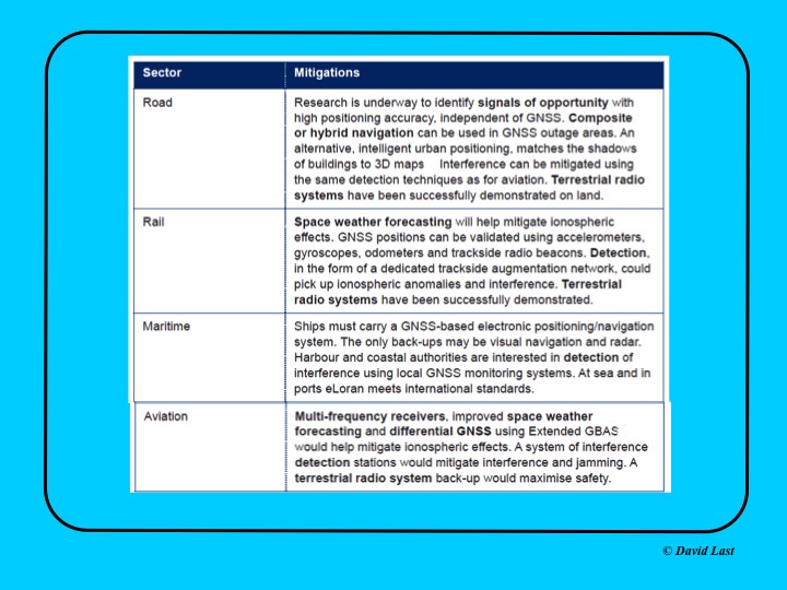
From the just-issued Blackett Report, the first figure displayed above presents recommended mitigations to impacts on GNSS applications in road, rail, maritime and aviation. Alternative options include composite or hybrid navigation, terrestrial radio systems, space weather forecasting, eLoran, various methods of interference detection, multi-frequency receivers and differential GNSS.
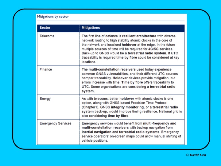
A second figure from Last’s presentation, shown above, covers the mitigations recommended for telecoms, finance, energy, and emergency services sectors. Mitigations for these applications include a resilient architecture with diverse network routing to high-stability atomic clocks, terrestrial radio systems, time-by-fiberoptics, multiconstellation receivers, holdover devices, GNSS integrity monitoring, and inertial navigation.
Concluding recommendations of the Blackett Report:
CNI operators to review and report on their reliance on GNSS. Cabinet Office to assess overall dependence of CNI on GNSS.
Add loss or compromise of GNSS-derived PNT to National Risk Assessment, not just as a dimension of space weather.
In allocating radio spectrum to new services and applications, address the risk of interference to GNSS-dependent users, including CNI.
Review the legality of the sale, ownership and use of devices and software to cause deliberate interference to GNSS receivers or signals.
Assess the need to monitor interference of GNSS at key sites such as ports and share the data with government
Employ GNSS-independent back-up systems.
Cross-government PNT Working Group to report to Cabinet Office on ways to improve national resilience.
Government to facilitate as those procuring GNSS equipment for CNI specify performance standards.
Map PNT testing facilities and explore how industry and critical services can better access them.
Leverage UK academic and industrial expertise in time and geo-location, increasing coordination among existing centres of excellence.