The 2013 European Navigation Conference (ENC 2013) will be held April 23-25 in Vienna, Austria. This will be the 17th conference in the GNSS series held under the auspices of the European Group of Institutes of Navigation (EUGIN) and is hosted by the Austrian Institute of Navigation (OVN).
ENC 2013 will focus on the present status as well as on future developments in navigation systems, with special emphasis on Galileo. The conference will be a showcase for state of the art and, more important, for innovations in the field of terrestrial and satellite navigation. The implementation of new technologies in navigation will be illustrated by the industry exhibition, running in parallel to the conference. The theme is “Navigation — Expanding our Horizons.”
The scientific program will be a combination of plenary lectures, parallel sessions, and poster presentations. Abstracts (paper or poster) with a maximum length of 1,000 words must be electronically submitted for peer-review. Submission deadline for abstracts is December 17.
The Soyuz ST-B launcher carrying the next two Galileo In-Orbit Validation satellites took off as scheduled on 18:15:00 GMT (11:15 PDT) October 12. Deployment of its twin satellites into orbit took place 3 hours 44 minutes after take-off. All the stages of the Soyuz vehicle performed as planned and the
Fregat-MT upper stage released the Galileo satellites into their targeted orbit at close to 23 200 km altitude.
CANSPACE Listserv reports, “NORAD/JSpOC are tracking three objects from the launch:
“Presumably, the first two (A and B) are the Galileo satellites. They are drifting towards their designated orbits.”
The European Space Agency (ESA) launched this second pair of Galileo IOV satellites from Europe’s Spaceport in French Guiana.
This flight is designated VS03 in Arianespace‘s mission numbering system, and it was the Spaceport’s third launch since Soyuz was introduced at this near-equatorial facility one year ago. Arianespace is the launch contractor.
The two Galileo satellites will join the first two spacecraft orbited by Arianespace’s historic VS01 flight on October 21, 2011, marking Soyuz’ introduction at the Spaceport. Once all four are operational in space, they will provide the minimum number of satellites required for navigational fixes — enabling system validation testing when all are visible in the sky.
As a European initiative, the Galileo satellite navigation system is being developed in a collaborative effort of the European Union and the European
Space Agency. The In-Orbit Validation (IOV) satellites weigh 700 kg. each and were built by a consortium led by the Astrium division of EADS — which
produced the platforms and has responsibility for the payloads, while Thales Alenia Space handled the assembly and testing tasks.
The European Union (EU) and China will be meeting in December in Paris to discuss overlapping radio frequencies both plan to use for their future encrypted government/military satellite navigation services, according to a joint statement from both parties, reports Space News.
The December meeting will be conducted under what the Joint Statement on Space Technology Cooperation specifies as the ITU Framework. ITU is the International Telecommunication Union of Geneva, a United Nations affiliate that regulates satellite orbital slots and frequencies.
The statement was signed as an annex to a broader EU-China summit held September 20 in Brussels. As Space News reports, the two sides are continuing collaboration on satellite navigation despite the signal conflict, which has been a subject of debate for at least two years. The 27-nation EU and China have agreed to continue the China-Europe GNSS Technology Training and Cooperation Center.
The European Space Agency (ESA) will be launching a second pair of Galileo IOV satellites tomorrow from Europe’s Spaceport in French Guiana.
The satellites will ride a Soyuz ST-B rocket from Europe’s Spaceport in French Guiana. Launch is scheduled for 18:15:00 GMT (20:15:00 CEST) October 12. Live streaming will begin at 17:48 GMT (19:48 CEST) for about one hour.
From launch to final deployment, when the dispenser releases the satellites sideways in opposite directions, takes three hours and 44 minutes. Live coverage resumes at 21:25 GMT (23:25 CEST).
This flight is designated VS03 in Arianespace‘s mission numbering system, and it will be the Spaceport’s third launch since Soyuz was introduced at this near-equatorial facility one year ago. Arianespace is the launch contractor.
The two Galileo satellites will join the first two spacecraft orbited by Arianespace’s historic VS01 flight on October 21, 2011, marking Soyuz’ introduction at the Spaceport. Once all four are operational in space, they will provide the minimum number of satellites required for navigational fixes — enabling system validation testing when all are visible in the sky.
As a European initiative, the Galileo satellite navigation system is being developed in a collaborative effort of the European Union and the European
Space Agency. The In-Orbit Validation (IOV) satellites weigh 700 kg. each and were built by a consortium led by the Astrium division of EADS — which
produced the platforms and has responsibility for the payloads, while Thales Alenia Space handled the assembly and testing tasks.
The IGNSS Society will be holding the 2013 conference & exhibition at the Outrigger Hotel, Gold Coast, Queensland, Australia, July 16-18, 2013.
The program will include keynote speakers, oral presentations, interactive poster sessions, panel sessions, open interactive forums, an informative trade exhibition, GNSS demonstrations and a field day.
Topics will include:
Status of GNSS (GPS, Galileo, GLONASS, Compass, QZSS)
Innovative GNSS Applications
Land Mobile Applications
Aviation and Aerospace Applications
Maritime Applications
Precise Timing
Machine Guidance and Automation
GNSS Interference and Signal Processing
Alternatives and Backups to GNSS
Multi-sensor Integration
GNSS Receiver Hardware Design
Software GNSS Receivers
Atmospheric Effects and Space Weather
Precise Carrier Phase-Based Positioning
Geodetic Infrastructure and Datums
Pedestrian and Indoor Navigation
GNSS Policy, Governance and Alternatives and Organisational Issues
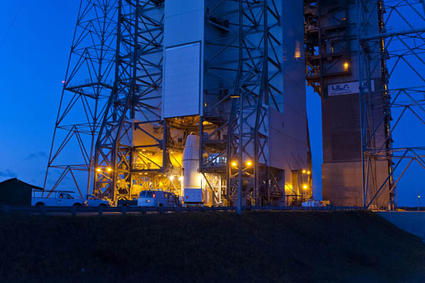
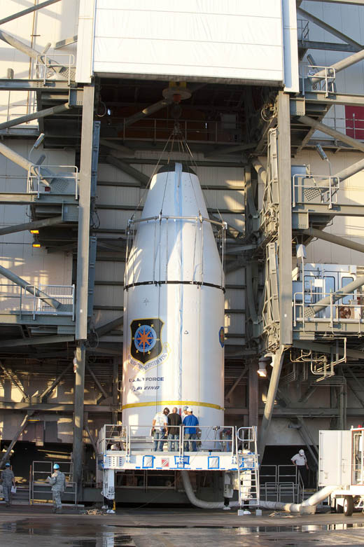
Soyuz VS03, the third Soyuz flight from Europe’s Spaceport in French Guiana, was transferred to the launch zone on October 8. The vehicle was rolled out horizontally on its erector from the preparation building to the launch zone and then raised into the vertical position, in preparation of the launch of two Galileo satellites.
Europe’s next two Galileo satellites have received technical clearance for their launch this Friday. They are currently resting in place atop their Soyuz launcher.
Yesterday saw the three-stage Soyuz ST-B launcher moved horizontally to the launch pad on the 600-meter long railway. It was then lifted into the vertical position to await the attachment of the Upper Composite — the combination of twin Galileo satellites, the dispenser holding them in place, the Fregat-MT upper stage and the protective fairing. Meanwhile, the satellites themselves underwent their formal Launch Readiness Review, after which the Upper Composite joined the Soyuz at the launch pad to be mated to the Soyuz that evening using the mobile gantry. The Soyuz and Upper Composite will undergo a full launch dress rehearsal in the remaining days before the 18:15:00 GMT (20:15:00 CEST) launch on October 12, including preparations for fueling the vehicle, which will begin four and a half hours before liftoff.
This follow-up launch marks a major step for Europe’s own satellite navigation system. Four is the minimum number of satellites needed to achieve a navigational fix on the ground, with one satellite each to measure latitude, longitude, altitude and provide a time reference. So once this second pair of satellites has been commissioned and tested, the quartet will form a completely operational mini-constellation that will be used to validate the Galileo system.
The performance of the satellites in space together with the worldwide ground infrastructure serving to maintain Galileo’s service accuracy will be assessed in depth, to prepare the way for the launch of further satellites and then deliver initial services by mid-decade and finally build up to full operational capability.
These two new satellites are also the first to carry search and rescue antennas to pinpoint aircraft and ships in distress as part of the international Cospas–Sarsat system.
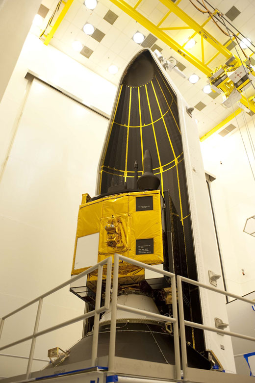
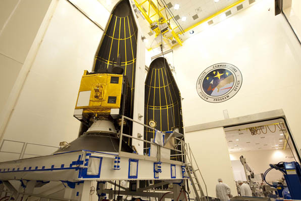
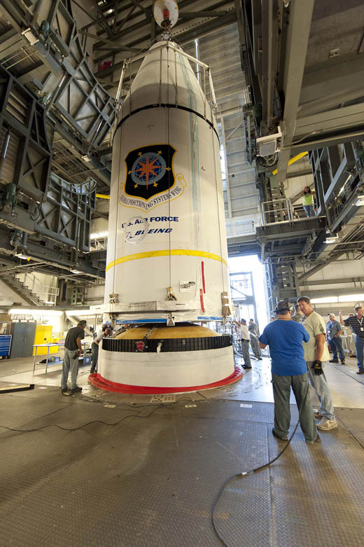
The two Galileo In-Orbit Validation satellites are protected during their launch by Soyuz by a launch fairing. Once the Soyuz has passed most of the way through the atmosphere, this fairing can then be ejected.
The Indian Space Research Organization has announced that the orbit-raising maneuvers of GSAT-10 satellite have been successfully completed from ISRO’s Master Control Facility, Hassan. GSAT-10 was launched September 30. The third and final orbit-raising maneuvers was performed October 3 to place the GSAT-10 in an orbit with 35,734 km apogee (farthest point to earth), 35,585 km perigee (nearest point to earth), and an inclination of 0.172 degree with respect to the equator. Currently, the orbital period of GSAT-10 is 23 hours 50 minutes.
According to the announcement from the Indian Space Research Organization, the two solar panels and the two dual gridded reflector antennas were also deployed later in the day. Currently, the satellite is in final orbital configuration at 70.18 degree East longitude. In the coming days, the satellite will be moved towards its designated location of 83 degree East and in-orbit testing of its communication and navigations payloads will be performed.
As is often the case, NORAD/JSpOC has temporarily “lost” the satellite following one of its orbital maneuvers. The last published two-line orbital element set for the satellite is dated September 30.
ITT Exelis has passed a major milestone for the U.S. Air Force’s Global Positioning System III (GPS III) program. The company has successfully completed acceptance testing of the navigation payload element for the GPS III Non-Flight Satellite Testbed (GNST), and shipped the pathfinder unit to prime contractor Lockheed Martin’s facility near Denver, Colo., for thermal vacuum testing and space vehicle integration.
In March 2012, Exelis announced that it had been awarded a $32 million contract by Lockheed Martin to build the navigation payloads for GPS III space vehicles three and four.
“The completion of this program milestone is testimony to the fact that we are focused on delivering GPS III capabilities to meet the needs of more than 1 billion users worldwide,” said Mark Pisani, vice president and general manager, Precision Instruments and Positioning, Navigation and Timing Systems, ITT Exelis Geospatial Systems. “We are excited for the next step in this program—delivering the Exelis navigation panel to Lockheed Martin for integration into the space vehicle.”
Affordably replacing and improving the current GPS satellites, GPS III will deliver better accuracy and improved anti-jamming power while enhancing the spacecraft’s design life and adding a new civil signal designed to be interoperable with international global navigation satellite systems.
“Completion of the GNST Navigation Panel Element is a very important milestone for this program,” said Keoki Jackson, vice president of Lockheed Martin’s Navigation Systems mission area. “This accomplishment was made possible by the tremendous teamwork between ITT Exelis, Lockheed Martin, the Aerospace Corporation and the U.S. Air Force. We look forward to integrating the panel onto our pathfinder vehicle and continuing to reduce risk early in the program, paving the way for very efficient and affordable satellite production.”
For nearly 40 years, Exelis payloads and payload components have been on board every GPS satellite and have accumulated more than 500 years of on-orbit life without a single mission-related failure due to Exelis equipment.
The GPS III team is led by the Global Positioning Systems Directorate at the U.S. Air Force Space and Missile Systems Center. Lockheed Martin is the GPS III prime contractor with teammates ITT Exelis, General Dynamics, Infinity Systems Engineering, Honeywell, ATK and other subcontractors. Air Force
Space Command’s 2nd Space Operations Squadron (2SOPS), based at Schriever Air Force Base, Colorado, manages and operates the GPS constellation for both civil and military users.
JAVAD GNSS has commented on some news that its receivers can track a new L5 signal from the Indian SBAS satellite, GSAT-8, launched on May 20. In a further explanation to GPS World, CEO Javad Ashjaee explained, “All owners of our products can track it. The only thing is that if customers have not updated their firmware for a long time, they should update to recent firmwares released earlier. They need to update their firmware, which is free of charge and is posted on our website. All of our customers with recent firmware versions can track the GAGAN L5 signal.”
An earlier report from CANSPACE that appeared on the GPS World website said, in part, “Although GSAT-8 reportedly carries a dual-frequency transponder, no L5 signals from this satellite have yet been detected by International GNSS Service tracking stations.”
The JAVAD GNSS statement on September 30 said “Report of GPS World that GAGAN PRN127 does not transmit L5 signal is not correct. Our receivers track it. This graph shows code-phase measurements for this signal.” The web page displays this figure:
A check with a University of Bern, Switzerland, report of stations participating in the IGS M-GEX campaign on October 2 found that a number of stations are tracking the L1 signal from GSAT-8 but none are tracking the L5 signal yet due to issues with receiver firmware. However, various stations in the Cooperative Network for GNSS Observation (formerly the Cooperative Network for GIOVE Observation, still abbreviated CONGO), using Javad Triumph receivers, have tracked GAGAN L1 and L5 signals for more than half a year. No detailed analysis of these measurements has been performed so far.
UPDATE: The SVN65/PRN24 L5 transmitter has now been switched on. L5 is the civilian safety-of-life GPS signal, designed to meet demanding requirements for safety-of-life transportation and other high-performance applications.
UPDATE: The GPS Block IIF-3 satellite, SVN65, began transmitting L1 and L2 signals as PRN24 on October 8. A number of stations of the International GNSS Service are now tracking the satellite. The satellite is included in broadcast almanacs although it is set unhealthy and will continue to be so until satellite commissioning is completed. The satellite is still drifting towards its designated orbital position of Slot 1 in Plane A.
Meanwhile, SVN27/PRN27 was decommissioned from active service on October 6 and removed from the broadcast almanacs. However, the L-band
transmitters of SVN27 remain active, presumably for end-of-life testing.
UPDATE: According to Boeing, the satellite manufacturer, SVN65 is on orbit and performing as expected. A Boeing press release stated that “Controllers confirmed initial contact with the spacecraft at 11:43 a.m. Eastern time. The satellite’s GPS signals will be turned on and tested within a few days.”
Incidentally, the launch occurred exactly 55 years to the day after the launch of the world’s first satellite, Sputnik I, on October 4, 1957. It was Doppler tracking of that satellite that gave rise to the Transit navigation system and subsequently, its successor, GPS.
The launch of the GPS Block IIF-3 satellite took place as scheduled October 4 at 12:10 UTC (8:10 a.m. EDT), aboard a United Launch Alliance Delta IV rocket from Cape Canaveral, Florida. Spacecraft separation was reported at 16:27 UTC.
The Boeing-built spacecraft is designed to improve network coverage for both civilian and military networks, including a new L5 signal for improved commercial and civil aviation users.
The satellite, also known as SVN65, will be positioned in orbital slot 1, which is in plane A and will use the PRN24 ranging codes. Slot 1 was recently occupied by a Block IIA satellite, SVN39, operating as PRN09. SVN39 is one of the oldest operating satellites in the GPS fleet, having been launched on 26 June 1993. SVN39 underwent an initital Delta-V on September 27 to move it close to SVN38/PRN08 in slot 3 in plane A, making room for the new Block IIF satellite.
“Congratulations to the entire team on today’s successful launch of the GPS 2F-3 satellite,” Jim Sponnick, ULA vice president, Mission Operations, said in a post-launch press release.
“ULA and our mission partners have a rich heritage with the GPS program and we are proud to have served alongside the government and contractor teams over the last two decades to provide important Global Positioning System capabilities for our national defense and for millions of civilian and commercial users around the world.”
A Delta IV rocket lifts-off with an advanced GPS satellite from Cape Canaveral on Thursday. (Credit: ULA/Atkeison).
2. GPS SATELLITE SVN65 (PRN24) WAS LAUNCHED ON JDAY 278.
A USABINIT NANU WILL BE SENT WHEN THE SATELLITE IS SET ACTIVE TO
SERVICE.
3. POC: CIVILIAN – NAVCEN AT 703-313-5900, HTTP://WWW.NAVCEN.USCG.GOV
MILITARY – GPS OPERATIONS CENTER AT HTTPS://gps.afspc.af.mil/
GPSOC , DSN 560-2541,
COMM 719-567-2541, [email protected] , HTTP://gps.afspc.af.mil/GPSOC/GPS
MILITARY ALTERNATE – JOINT SPACE OPERATIONS CENTER, DSN 276-3514.
COMM 805-606-3514. [email protected]
Lift-off is set for 8:10 a.m. EDT (1210 GMT) Thursday for a GPS IIF satellite, reports Spaceflight Now. GPS IIF-3 will replace an aging 19-year-old craft in plane A, slot 1, part of the program to incrementally upgrade the GPS constellation with greater accuracy, better jam-resistance, and a new civilian aviation signal, all of which are features of the Boeing-build Block IIF series.
The United Launch Alliance Delta 4 rocket and GPS satellite payload will undergo a final technical assessment today and a readiness review Tuesday before entering into countdown operations Wednesday night.
The 19-minute launch window is timed to deliver the GPS IIF-3 satellite directly into plane A of the navigation network 11,000 miles above Earth.
The satellite is expected to be checked out and ready for handover to Air Force controllers by mid-November, according to Jan Heide, Boeing’s GPS program director.
A pair of Galileo satellites are now fully fueled and mated together atop the upper stage that will haul them most of the way up to their final orbit. The launch is planned for the evening of October 12, reports the European Space Agency.
Technicians donned protective suits to fill the two satellites’ tanks with hydrazine fuel, used to maintain the satellites’ attitude and orbital position during their planned 12-year lifetime.
Rather than carry a significant amount of extra fuel to insert themselves into their planned orbits – like typical telecommunications satellites or Galileo’s US GPS equivalents – the Galileo satellites are transported to medium orbit by the Fregat fourth stage of their Soyuz ST-B launcher.
Doing without this extra fuel and orbital thrusters means that Galileo satellites are small enough to be launched in pairs aboard the Soyuz – or in fours by the new Ariane 5 variant currently being prepared.
The Galileo satellites are attached to a special dispenser that holds them securely in position during launch, before pyrotechnic mechanisms release them sideways in opposite directions once their set 23 222 km altitude is reached.
The aluminum plates on each side of the satellites are temporary additions to protect their delicate solar panels; these will be removed later.
Galileo’s fit-check with dispenser (credit: ESA).
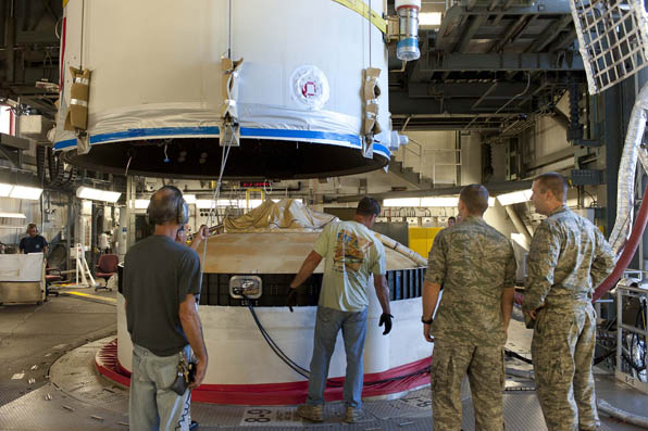
The combined satellites, dispenser and Fregat upper stage will now be carefully checked ahead of the next major milestone, the fitting of the protective launch fairing on Thursday.
The mission’s satellite launch readiness review will begin at the start of the following week. If that goes well, the combined ‘Upper Composite’ will be moved from the Fregat Integration Building to the launch pad, where it will be attached to the Soyuz launcher.
Completing Galileo’s validation phase
The launch will see these two new Galileo In-Orbit Validation satellites joining the first two that have been orbiting since October 2011.
This is a significant milestone for Europe’s Galileo programme because four is the minimum number required for navigational fixes, enabling full system testing whenever they are all visible in the sky.
This validation phase will be followed by the deployment of more satellites and ground segment components to achieve ‘Full Operational Capability’. After that, users on the ground can exploit the services.
The first four Galileo satellites were built by a consortium led by EADS Astrium, Germany, with Astrium producing the platforms and Astrium UK responsible for the payloads. They were assembled and tested in Rome by Thales Alenia Space.
Galileo IOV in orbit (artist’s rendering, courtesy of ESA.)