Europe’s regional satellite-based augmentation system (SBAS), EGNOS, has received upgrades to advance the reliability of GNSS positioning information, according to EUSPA.
Historically, EGNOS has provided safe, uninterrupted satellite navigation services to aviators, and some maritime, railroad, and land-based users in Europe. This system upgrade includes extending its service area, adding advanced functionalities, and reinforcing dual-frequency and multi-constellation services.
The EGNOS V242B system upgrade will expand services outside of its service area and enhance availability to users. Additionally, the upgrade ensures aviator access to lifesaving services such as Localizer Performance with Vertical Guidance (LPV)-200. The upgrade also includes more advanced data processing functions to cater to increased issues with peak solar activity and ionospheric phenomena that interfere with EGNOS signals and services.
Dual-frequency and multi-constellation services were also improved in the EGNOS upgrade. The improvements revamped EGNOS Version 2, and reinforced EGNOS services before launching EGNOS Version 3 (V3).
EGNOS delivers two frequencies and has amplified Galileo signals, hence creating a multi-constellation capability. When EGNOS V3 is launched, it will offer additional services and enhance protection against cyberattacks, further advancing EGNOS’ safety-critical applications across Europe.
Multinational technology firm GMV has signed an agreement with Lockheed Martin Corporation to develop the processing and control centers for the Southern Positioning Augmentation Network system (SouthPAN). Lockheed is contracted to establish SouthPAN.
The project is a joint initiative of the Australian and New Zealand governments to provide a satellite-based augmentation system (SBAS) for navigation and precise point positioning (PPP) services. GMV will also be responsible for monitoring both of these services in the region and for ensuring compliance with the committed performance levels.
SBAS and PPP systems have applications in industries as diverse as agriculture and road, air, maritime and rail transportation, as well as in the field of geomatics. SouthPAN is expected to accelerate development of applications in these areas.
SouthPAN is also the first system with these characteristics available in the Southern Hemisphere. With this new program, Australia and New Zealand will be contributing to improved global coverage and interoperability for services of this type, joining the list of countries and regions that already have their own SBAS system: the United States (WAAS), Europe (EGNOS), India (GAGAN) and Japan (MSAS).
On Sept. 26, two weeks after the agreement was signed, the first services were provided by activating transmission of the system’s first signals. This was a significant milestone, because SouthPAN is the first project where an industry consortium provides an SBAS as a service, rather than as a turnkey system.
Image: SouthPAN
GMV’s role
GMV will be responsible for developing two key subsystems for SouthPAN: the Corrections Processing Facility and the Ground Control Center. The company will also be responsible for monitoring the system and ensuring it complies with the committed performance levels.
GMV also will provide support for the system’s operation and maintenance.
Corrections Processing Facility. The facility generates correction messages for signals transmitted by GPS and Galileo, improving precision for users by improving accuracy to as little as 10 centimeters.
The facility also detects malfunctions in the satellites and generates warnings for users. This will allow use of SouthPAN by civilian aircraft as a navigation system during various flight operations, including precision approaches to runways for landing.
Safety-of-life services such as these will be available in 2028.
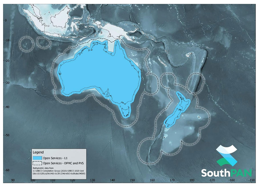
SouthPAN early Open Services coverage. OS-L1 covers mainland Australia and New Zealand. OS-DFMC and OS-PVS cover Exclusive Economic Zones in both countries. (Image: Geosciences Australia)
Ground Control Center. The control center remains in operation 24 hours a day seven days a week, and will perform all the functions needed to monitor and control the system. It will also provide information to users about the system’s operation and availability of services.
In Australia, SouthPAN development, entry into service and operation are being supervised by Geoscience Australia in collaboration with Toitū Te Whenua Land Information New Zealand.
In 2020, the two agencies signed the Australia New Zealand Science, Research and Innovation Cooperation Agreement (ANZSRICA). Over the next 20 years, the Australian government will be contributing 1.4 billion Australian dollars to the SouthPAN project.
SouthPAN provides accurate, reliable and instant positioning services across all of Australia and New Zealand’s land and maritime zones without the need for mobile phone or internet coverage. It will improve positioning from 5-10 meters, to as little as 10 centimeters — a 50-fold increase in accuracy.
The SouthPAN satellite-based augmentation system (SBAS) test-bed project took place between 2017 and 2019, demonstrating the value of SouthPAN to Australian and New Zealand economies and communities. Economic analysis indicates that it is more than $6.2 billion for Australia alone.
In February 2020, Geoscience Australia and Toitū Te Whenua Land Information New Zealand (LINZ) began a joint collaboration on SouthPAN under the Australia New Zealand Science, Research and Innovation Cooperation Agreement (ANZSRICA). A comprehensive procurement process followed, awarding an AUD$1.18 billion, 19-year contract on Sept. 16 to Lockheed Martin Australia.
“The SouthPAN project team will work with Lockheed Martin Australia to establish a network of Global Navigation Satellite System reference stations, a corrections processing facility and satellite uplink facilities that will enable accurate and reliable positioning signals to be transmitted from satellites to users,” said Madeleine King, Minister for Resources and Northern Australia. “The SouthPAN services will be fully operational across the two countries with safety-of-life certification from 2028.”
Benefits from SouthPAN
With early Open Services, Geoscience Australia and Toitū Te Whenua Land Information New Zealand enable industry access to SouthPAN. Early Open Services can immediately integrate with existing equipment or products, to create or enhance positioning service offerings to end-users.
Early Open Services will bring widespread benefits across agriculture, construction, resources and many other industries, paving the way for technological advancements in automation, including:
heavy vehicle automation, such as truck platooning, where vehicles can connect to each other as a group to transport goods
precision agriculture applications such as yield mapping, controlled traffic farming, inter-row seeding, precision spraying and livestock management
personnel safety on mine and construction sites, through smart geofencing technologies that accurately identify the locations of workers with key equipment, such as vehicles and heavy machinery.
SouthPAN is estimated to generate more than AUD$6 billion in benefits to the Australian economy over the next 30 years.
King said the new network will allow
mining companies to install more accurate collision avoidance systems on automated mining haul trucks
visually impaired citizens to navigate cities with pinpoint assistive technologies
light aircraft to land more safely in remote rural areas in all weather conditions, including essential services such as The Royal Flying Doctor Service.
The joint Australia-New Zealand initiative will be a game-changer for the economies of both nations, said Damien O’Connor, New Zealand minister for land information.
“This technology was originally developed to support aviation safety, but as technology has advanced, the applications have expanded,” O’Connor said. “It now has potential uses as varied as enabling accurate vehicle guidance for efficiencies in agriculture and horticulture management, tracking maritime shipments, and enabling navigation for drones and other unmanned vehicles.”
Early Open Services
SouthPAN will provide three early Open Services.
L1 SBAS Open Service. The L1 SBAS early Open Service will provide navigation messages on the L1 frequency (1,575.42 MHz), and allow users with a receiver that tracks GPS L1 C/A signals to improve their position accuracy to better than ≤3m in the horizontal and ≤4 m in the vertical (95% confidence interval).
DFMC SBAS Open Service. The Dual-Frequency Multi-Constellation SBAS early Open Service will provide navigation messages on the L5 frequency (1,176.45 MHz), and allow users — with a receiver that tracks GPS L1 C/A and L5 signals, and Galileo E1 and E5a signals — to improve their position accuracy to better than ≤1.5m in the horizontal and ≤2.5 m in the vertical (95% confidence interval).
PVS Open Service. The Precise Point Positioning (PPP) via SouthPAN (PVS) early Open Service will share the L5 frequency with the DFMC SBAS Open Service in the near future, before transitioning to a new navigation signal. PVS will allow users — with a receiver that tracks GPS L1 C/A and L5 signals and Galileo E1 and E5a signals, and is capable of processing the PVS messages — to improve their position accuracy better than ≤0.40 m in the horizontal and ≤0.55 m in the vertical (95% confidence interval) after convergence. Convergence will be better than 80 minutes during PVS early Open Services, and the user does not need to remain stationary during the convergence period.
SouthPAN early Open Services coverage. OS-L1 covers mainland Australia and New Zealand. OS-DFMC and OS-PVS cover Exclusive Economic Zones in both countries. (Image: Geosciences Australia)
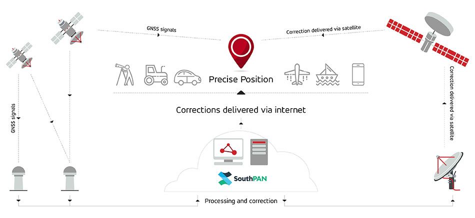
SouthPAN uses several distributed ground stations to monitor signals broadcast by GNSS satellites, and compares each station’s known location with position data from the satellites.
The GNSS signal data and measurement information is sent to correction processing facilities. The facilities aggregate the data from all ground stations, produce error corrections and status information about the GNSS satellites, and format the data in a standardized series of messages. These messages are sent to an uplink station, which transmits the data to a satellite in geostationary earth orbit. The data is broadcast to all precise positioning users, who combine SouthPAN’s data with their own observations of GNSS satellites.
SouthPAN early Open Services coverage. (Image: Geosciences Australia)
The government of Australia has awarded Lockheed Martin a $1.18 billion contract to establish the Southern Positioning Augmentation Network (SouthPAN) to enhance precision.
The system is expected to be fully operational by 2028, and will be provided as a service for 19 years with an option to extend.
The program will use a unique, Lockheed Martin-developed, second-generation satellite-based augmentation system (SBAS) broadcasting on two frequencies to augment signals from two GPS and Galileo.
The SouthPAN initiative
The SouthPAN initiative will deliver a signal augmenting GPS and Galileo over the Australasia region, improving accuracy from 5-10 meters to within as little as 10 centimeters.
The greater positioning accuracy and integrity of the SouthPAN signal has applications across a range of users, including civil aviation, vehicle guidance, precision agriculture for efficiencies in crop management, tracking maritime shipments, and enabling navigation for drones and other unmanned vehicles.
Lockheed Martin Australia will work with the SouthPAN project team to establish a network of GNSS reference stations and satellite uplink facilities that will enable communications and transmissions with the SouthPAN space infrastructure.
SouthPAN is a partnership between Geoscience Australia and Toitū Te Whenua Land Information New Zealand (LINZ) under the Australia New Zealand Science, Research and Innovation Cooperation Agreement.
2017 testbed
Lockheed Martin tested a second-generation SBAS testbed in partnership with Geoscience Australia in 2017.
Lockheed Martin’s second-generation SBAS technology receives and monitors basic signals data from multiple GNSS through widely distributed reference stations. This data is collected by a SBAS testbed master station, which computes corrections and integrity bounds for each GNSS satellite signal, and generates augmentation messages.
The new messages are sent to an SBAS payload hosted aboard an Inmarsat geostationary Earth orbit satellite via an uplink antenna in Uralla, New South Wales. The Inmarsat satellite rebroadcasts the augmentation messages containing corrections and integrity data to the end users’ GNSS receivers. The whole process takes less than six seconds.
Lockheed Martin provided the systems integration expertise in addition to the Uralla radio frequency uplink; GMV-Spain provided its “magicGNSS” processors; Inmarsat provided the navigation payload hosted on the 4F1 geostationary satellite. The Australia and New Zealand Cooperative Research Centre for Spatial Information coordinated the demonstrator SBAS test-bed SBAS test-bed projects.
The SouthPAN contract will expand Lockheed Martin’s investments toward sustainable business growth in Australia. Currently, Lockheed Martin programs support 4,000 Australian jobs in advanced manufacturing and technology industries. The contract will grow that footprint with additional jobs in at least four states.
Telit has released the SE873K5 multi-constellation GNSS receiver in the L1 band. The SE873K5 simultaneously tracks and navigates all four GNSS constellations — GPS, Galileo, GLONASS and BeiDou — providing GNSS information over a UART, I2C or SPI interface serial port using the NMEA protocol.
Based on the AG3335 system-in-package from Airoha, the SE873K5 is the latest addition to Telit’s SE873 family of modules and the natural migration path from SE873 and SE873Q5.
The module is a 7mm x 7mm x 2.25mm QFN-like semiconductor package with embedded SPI flash, RTC and TCXO. With its compact size, the latest generation chipset and the advanced power modes, the SE873K5 has the benefits of low cost, small form factor and good electrical and thermal performance — suitable for wearables, fleet tracking, drones and more.
The SE873K5 low-power processing core delivers customizable power-saving modes. It optimizes current draw at module wake-up by supporting both local- and server-based assisted GNSS (A-GNSS) for improved time to first fix, while satellite-based augmentation system (SBAS) corrections from WAAS, EGNOS, MSAS or GAGAN increase positioning accuracy.
The internal flash memory allows firmware updates and customization, as well as ephemeris predictions storage.
Yang Changfeng is BeiDou’s Chief Architect. (Photo: BeiDou Navigation Satellite System)
Construction of the BeiDou Navigation Satellite System (BDS-3) has been completed. The system was formally commissioned on July 31, 2020. In 2021, BDS continued to improve performance, expand applications and deepen cooperation, and has achieved sustained, stable and rapid development.
System Performance and Services
Currently, 45 BDS satellites are operational in orbit — 15 BDS-2 satellites and 30 BDS-3 satellites jointly provide seven types of services to users. Specifically, for the entire planet, the system provides three services:
Positioning, navigation and timing (PNT).
Global short-message communication.
International search-and-rescue (SAR) services.
For the Asia-Pacific region, the system provides four additional services:
Satellite-based augmentation.
Ground-based augmentation.
Precise point positioning.
Regional short-message communication services.
The system has been operating continuously and stably since commissioning, with the average value of satellite availability better than 0.99 and the average value of satellite continuity better than 0.999.
PNT Service. As actually measured by the International GNSS Monitoring and Assessment System (iGMAS), the global horizontal positioning accuracy is about 1.52 meters, the vertical positioning accuracy is about 2.64 meters (B1C signal single frequency, 95% confidence), the velocity measurement accuracy is better than 0.1 m/s, and timing accuracy is better than 20 nanoseconds. The performance is better in the Asia-Pacific region.
FIGURE 1 shows the number of visible BDS satellites worldwide at BDT 00:00 on Nov. 18, 2021. Among them, the number of visible BDS satellites exceeds 20 in some areas of the Asia-Pacific region.
Figure 1. Number of visible BDS satellites, elevation ≥5° (2021/11/18/00:00 BDT). (CREDIT: www.csno-tarc.cn)
Global Short Message Communication Service. Trial service is provided through 14 medium-Earth-orbit (MEO) satellites for authorized users and low-orbit satellites, with a maximum single-message length of 560 bits, equivalent to about 40 Chinese characters.
Search-and-Rescue Service. A COSPAS/SARSAT-compliant MEOSAR service is provided by six payloads deployed on six MEO satellites. A B2b signal-based Return Link Service (RLS) is provided through 24 MEO and three IGSO satellites, which have completed testing and verification and are in the process of coordination within the framework of COSPAS-SARSAT.
Satellite-Based Augmentation Service. China’s Civil Aviation Administration is organizing satellite-ground integrated test and evaluation, and the positioning accuracy, alarm time, integrity risk and other indicators meet the requirements.
Ground-Based Augmentation Service. Real-time centimeter-level and post-processing millimeter-level services are provided for industrial and public users, based on the regional network reference stations built in China.
Precise Point Positioning Service. PPP signals are broadcast by three GEO satellites. The measured horizontal positioning accuracy is 0.24 m, the vertical positioning accuracy is 0.41 m (95% confidence), and the convergence time is less than 20 minutes.
Regional Short Message Communication Service. The short-message communication function has been tested and verified for integration into public mobile phones; large-scale application is planned.
Development of the Applications Industry
Large-scale applications of BDS have entered a critical stage of liberalization, industrialization and internationalization. The overall output value of China’s satellite navigation and location-based service industry continued to grow in 2020, up to 403.3 billion yuan (US$63.2 billion), which is about 16.9% more than its value in 2019. In terms of BDS-3-enabled basic products, an industrial chain is gradually maturing, comprised of BDS/GNSS basic chips, modules, boards, antennas and other components.
The certification and testing system of basic BDS products has been established and implemented. BDS is already supported by most mainstream chips. BDS is increasingly being integrated into the daily life of the general public. It is becoming the standard configuration for positioning functions of smartphones and other mass-market products.
Smartphone manufacturers such as Xiaomi, Huawei, Apple and Samsung already support BDS. In the first three quarters of 2021, among all types of smartphones applying for online access in China, 72.3% supported positioning function based on BDS, accounting for 93.5% of the total sales volume. The BDS ground-based augmentation function has been introduced into smartphones to achieve high-precision positioning at the 1-meter level; lane-level navigation is being piloted in several cities in China.
In terms of industrial applications, BDS has fully served multiple industries including transportation, public security, disaster relief, agriculture, forestry, animal husbandry and fishing. It has accelerated the integration into electricity, finance, communications and other infrastructure. In particular, in the fight against COVID-19 through scientific and technological approaches, BDS-based precise positioning has facilitated the efficient supply and circulation of anti-epidemic materials.
BDS-based solutions for land rights determination, precision agriculture and smart ports have served the economic and social development of countries in Asia, Eastern Europe and Africa, and BDS-based products have been applied in more than half of the world’s countries and regions.
International Cooperation
BDS has always adhered to the development concepts of openness, cooperation and resource sharing; actively carried out practical international exchanges and cooperation; and contributed to China’s peaceful use of outer space.
Bilaterally, the Eighth Meeting of the China-Russia Project Committee on Major Strategic Cooperation in Satellite Navigation was held in October 2021. Both sides jointly formulated and signed the Roadmap for Cooperation in the Field of Satellite Navigation from 2021 to 2025, providing planning and guidance for China-Russia satellite navigation cooperation in the next five years. Also, China’s Satellite Navigation Office signed a memorandum of understanding on satellite navigation cooperation with the National Committee on Space Activities of the Republic of Argentina and the South African National Space Agency, and formally established a regular cooperation mechanism.
BDS is gradually being integrated into international standards, and is steadily promoting ratification by international standards bodies, including in the civil aviation, maritime, SAR, mobile communications and electrotechnical fields. Several international standards supporting BDS have been released. The Chinese government has drafted a letter of commitment to the International Civil Aviation Organization (ICAO), stating that BDS will provide basic services free of charge to civil aviation users around the world. The International Association of Marine Aids to Navigation and Lighthouse Authorities (IALA) has officially issued a standard that ratifies BDSBAS, so that global marine users can carry out applications based on it. The Third Generation Partnership Project has started the standardization of BDS-3’s B2a and B3I signals. In the detection standard for Indicating Radio Beacon Locator of the Global Maritime Distress and Safety System issued by the International Electrotechnical Commission, BDS receivers and BDS-based SAR services will be supported.
The Chinese government is steadily advancing the rule of law, attaching great importance to and comprehensively promoting the rule of law for satellite navigation. A legal system on BDS has been formed, consisting of national policies, industrial and local policies and regulations, and more. The legislative process of the Satellite Navigation Regulations of the People’s Republic of China has been actively promoted to ensure the healthy, rapid and sustainable development of the satellite industry. In May 2021, China issued a development report on the rule of law of BDS.
Follow-Up Plan
In the future, on the one hand BDS will ensure stable operation, while on the other hand it will focus on the development of backup satellites, and complete the production, state optimization and ground testing of backup satellites. Backup BDS-3 satellites with better performance will be launched as needed to further improve the reliability of the constellation. By adhering to the development concept of “BDS is developed by China, dedicated to the world and aiming to be first class,” carrying forward the BDS spirit of the new era of “independent innovation, open integration, unity of all, pursuit of excellence,” BDS will serve the world and benefit all humankind.
Number of BDS-3 satellites in orbit: 30
Signals broadcast: B1I, B3I, B1C, B2a, and B2b
Yang Changfeng is chief architect of the BeiDou Navigation Satellite System and a Chinese Academy of Engineering academician.
The Airbus A350 can now be equipped with the Collins Aerospace GLU-2100 multi-mode receiver. (Photo: pablorebo1984/iStock/Getty Images Plus/Getty Images)
The Collins Aerospace GLU-2100 multi-mode receiver (MMR) has received approval by Airbus, making it available as line-fit and retrofit on Airbus A320, A330 and A350 aircraft. This a major step toward Collins offering next-generation GNSS to the commercial aviation marketplace.
An MMR assists pilots in positioning, navigating and landing an aircraft. Building on the GNSS capabilities of previous MMRs, the GLU-2100 provides a satellite-based augmentation system (SBAS) and ground-based augmentation system (GBAS). This supports the integrity of the aircraft position, as well as the accuracy and availability of demanding aircraft operations such as landing in low visibility conditions.
The GLU-2100 MMR ensures that commercial aircraft can meet flight zone global mandates, while also proofing the technology by providing a solid foundation for future growth. It includes the flexible hardware baseline necessary to implement future GNSS capabilities, such as multi-frequency and multi-constellation (MFMC), and GBAS Category II/III via software-only update.
Acquisition of FlightAware tracking platform
In August, Collins Aerospace signed a definitive agreement to acquire privately held FlightAware, a digital aviation company providing global flight-tracking solutions, predictive technology, analytics and decision-making tools.
Closure of the acquisition is subject to the completion of customary conditions and regulatory approvals. Following closing, FlightAware will join Collins’ Information Management Services portfolio within the company’s Avionics strategic business unit. Financial terms of the agreement were not disclosed.
Based in Houston, Texas, with approximately 130 employees, FlightAware was founded in 2005 and is a provider of real-time and historical flight information and insights to the global aviation community. FlightAware serves all segments of the aviation marketplace through applications and data services that provide comprehensive information about the current and predicted movement of aircraft.
Through the collection, interpretation and enrichment of hundreds of sources of data, FlightAware transforms millions of raw flight data elements and delivers them as coherent, easy-to-consume flight stories. The company has a proprietary terrestrial ADS-B network with tens of thousands of receivers spanning seven continents in 200 countries and territories.
The General Lighthouse Authorities (GLA) of the United Kingdom and Ireland has named Alan Grant to the top post of its research and development team. Grant assumed his new role on Nov. 1.
As part of his duties, he heads the GLA’s research and development program, considering existing and future maritime requirements and operational strategy. GLA Research and Development (GRAD) is tasked with improving maritime safety by developing innovative and cost-effective maritime aids-to-navigation (AtoN).
GRAD projects have included all aspects of AtoN including human and machine interaction, operational life and environment. The team has deep technical expertise and experience with automatic identification systems (AIS) , the VHF Data Exchange System (VDES) , eLoran, e‑navigation, GNSS, SBAS and visual signaling.
The organization is well known for its expertise in electronic navigation aids and was an important contributor to the MarRINav project. The project effort was funded by the European Space Agency and examined what combination of electronic aids to navigation are needed to ensure uninterrupted UK shipping.
Grant joined the GLA in 2003 and has worked on a variety of systems during his time with GRAD. He led a series of successful GPS jamming trials and the development of the multi-system radionavigation receiver performance standards, from initial concept to international recognition at the IMO. He continues to support resilient positioning, navigation and timing in maritime navigation at both technical and strategic levels.
Grant is a Fellow of the Royal Institute of Navigation, where he is a member of the council and served as vice president, 2019-2021. He is also a member of the U.S. Institute of Navigation and served on the ION Council, 2013-2017.
Grant chairs the International Association of Marine Aids to Navigation and Lighthouse Authorities (IALA) radionavigation services working group and is a member of several international standards bodies. He is a chartered engineer, a chartered physicist, and author of more than 120 journal papers, magazine articles, and conference papers.
Martin Bransby, the prior GRAD leader, has taken a position with Telespazio in the UK.
Longstone Lighthouse is situated on the Outer Farne Islands on the Northumberland Coast in Northern England. (Photo: ad_foto/iStock/Getty Images Plus/Getty Images)
A team of companies and government agencies is developing satellite services provided by ASECNA’s A-SBAS (Satellite-Based Augmentation System) for Africa and the Indian Ocean. Besides the current SBAS, the joint venture will deliver precise point positioning (PPP, through CNES and Geoflex) and danger warnings for a wide range of applications in Africa.
Working together are the Agency for Air Navigation Safety in Africa and Madagascar (ASECNA), Nigerian Communications Satellite Ltd. (NIGCOMSAT) and Thales Alenia Space, the joint venture between Thales (67%) and Leonardo (33%). The project is backed by Geoflex, a provider of cloud services that deliver improvements to GPS/GNSS applications to achieve positioning accuracy to within 4 centimeters on land, at sea and in the air.
The new SBAS services are expected to aid agriculture and other sectors in Africa. Here,volcanic cinder cones and farming in rich volcanic soils on the border of the Democratic Republic of Congo and Rwanda. (Photo: iStock/Getty Images Plus)
Demonstrations
The three partners successfully demonstrated the additional services on July 7 and 8 in Brazzaville, Congo, by calling on the SBAS signal they have broadcast over the Africa and Indian Ocean (AFI) region since September 2020 to provide the first SBAS open service in this part of the world via the NigComSat-1R satellite. This trial follows successful flight demonstrations this year in Lomé in January and Douala in June.
The first demonstration of the special urgent situation warning service via satellite showed the system’s ability to broadcast a warning message via the A-SBAS signal to mobile phones, without requiring a terrestrial network. This service sends a message to the populations concerned, providing information on the type of danger and instructions to be followed.
The second demonstration entailed the transmission of GNSS corrections based on CNES/Geoflex PPP technology and also using the A-SBAS signal. This approach showed the system’s ability to achieve positioning accuracy to within centimeters across the entire African continent.
The new satellite service paves the way for applications in a broad range of sectors, including precision agriculture, land and maritime transport, rail safety, drone navigation, mapping and surveying. The ASECNA SBAS was developed as part of the ‘’SBAS for Africa & Indian Ocean’’ programme as a first step towards providing robust navigation services in the aviation sector.
ASECNA’s 18 Member States are Benin, Burkina Faso, Cameroon, Central African Republic, Comoros, Congo, Côte d’Ivoire, France, Gabon, Guinea Bissau, Equatorial Guinea, Madagascar, Mali, Mauritania, Niger, Senegal, Chad and Togo.
Europe’s EGNOS satnav system has been providing safety-of-life services for 10 years. EGNOS, the European Geostationary Navigation Overlay Service, transmits signals from a duo of satellite transponders in geostationary orbit.
The satellite-based augmentation system (SBAS) gives additional precision to U.S. GPS signals, delivering an average precision of 1.5 meters over European territory, as much as a 10-fold improvement over unaugmented signals. EGNOS also provides confirmation of GPS signal integrity through additional messaging identifying any residual errors.
While the EGNOS Open Service has been in general operation since 2009, EGNOS began its safety-of-life service in March 2011.
The European Space Agency (ESA) designed EGNOS as the European equivalent of the U.S. Wide Area Augmentation System (WAAS), working closely with the European air traffic management agency Eurocontrol. ESA then passed EGNOS to the European GNSS Agency (GSA) to run operationally.
Guiding airliners
EGNOS’s primary customer is aircraft. Without guidance from the ground, pilots using EGNOS can confidently descend in bad weather to 60 meters’ altitude before needing to make visual contact with the tarmac.
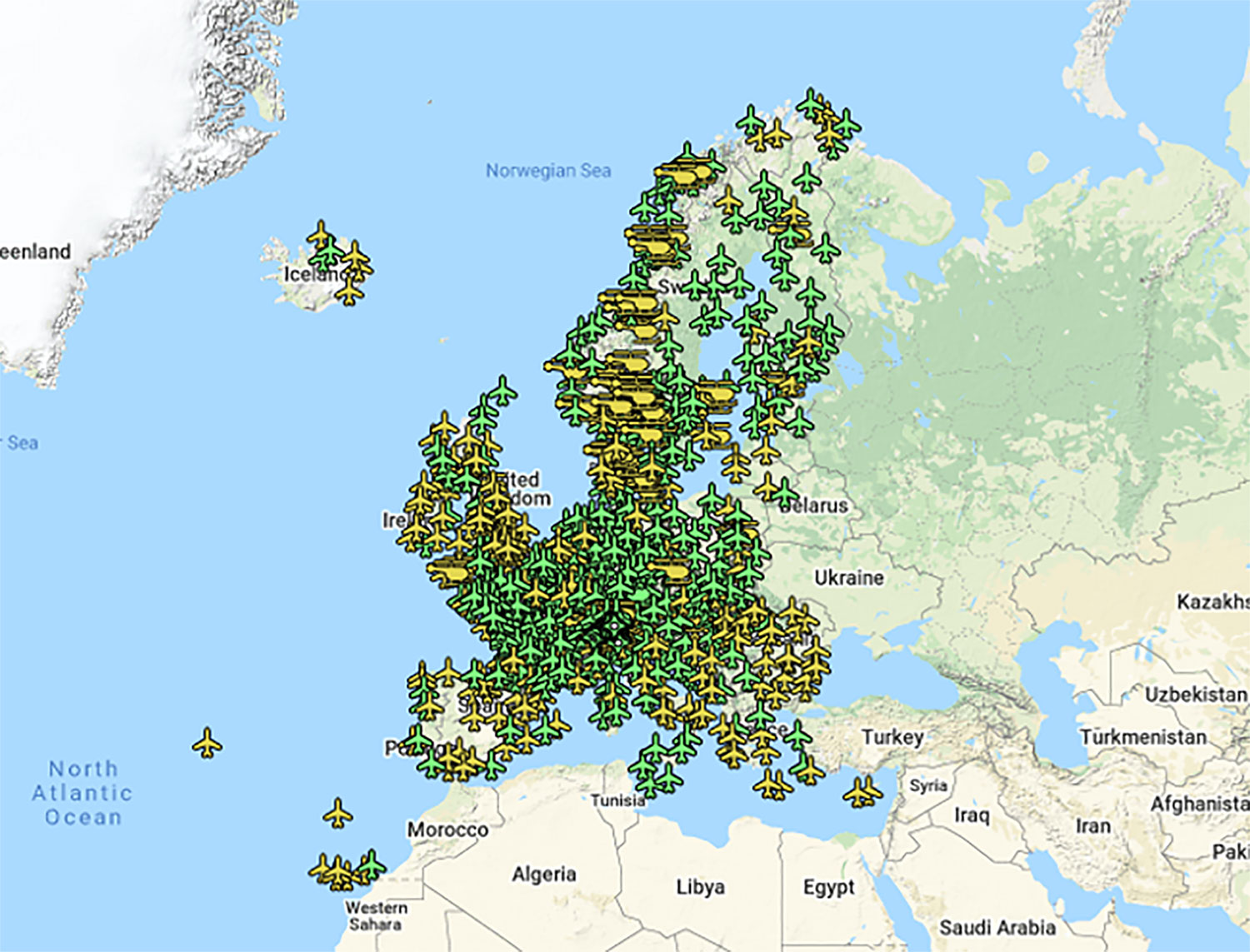
On March 17, 2011, France’s Pau Pyrénées Airport was the first airport to use EGNOS. Today, more than 385 airports and helipads and 60 airlines across Europe use EGNOS-based LPV-200 approaches (short for Localizer Performance with Vertical guidance – 200 feet). The EGNOS service requires no ground equipment, and replaces the radio guidance beamed upward by traditional CAT I instrument landing system (ILS) infrastructure with no decrease in performance.
As of March 2021, more than 385 airports and helipads and 60 airlines across Europe are using EGNOS-based LPV-200 approaches. (Image: ESA)
Serving drones
EGNOS is now being eyed as the enabler of unmanned aerial vehicles (UAVs). The GSA has supported numerous trials of drones equipped with EGNOS as well as Galileo through its EGNSS4RPAS project. Crewed aircraft are expected to be vastly outnumbered in our skies by all kinds of UAVs, employed for everything from weather and environmental monitoring to personalized delivery services.
U-Space is Europe’s program to integrate drones into the airspace. (Image: ESA)
The traditional person-based air traffic control model will need to evolve to accommodate such a shift, based on automated monitoring, traffic management and collision avoidance. In Europe, this highly automated version of air traffic control is termed U-space.
EGNOS’s safety-of-life service is essential to making this happen, moving from today’s situation — where drones are limited to specific air corridors and line-of-sight operations — to let them roam freely but safely in busy airspace and built-up areas.
“The whole idea behind EGNOS’s safety-of-life has been to render satellite navigation sufficiently reliable for any kind of use,” explained Didier Flament, who leads ESA’s EGNOS team. “After 10 years of faultless operations, new applications are becoming plain. Drone flight is one example. EGNOS is also being evaluated for train positioning as well as assisted and autonomous automobile driving.”
EGNOS, the next generation
ESA retains responsibility for the system’s evolution, and the middle of this decade should see the debut of its new generation, EGNOS v3.
“While the current system only works with single-frequency GPS signals, EGNOS v3 will operate on a multi-frequency, multi-constellation basis, able to augment all available satellite signals in both L1 and L5 bands, including Galileo,” Didier said. “The result will be far enhanced performance and reliability.
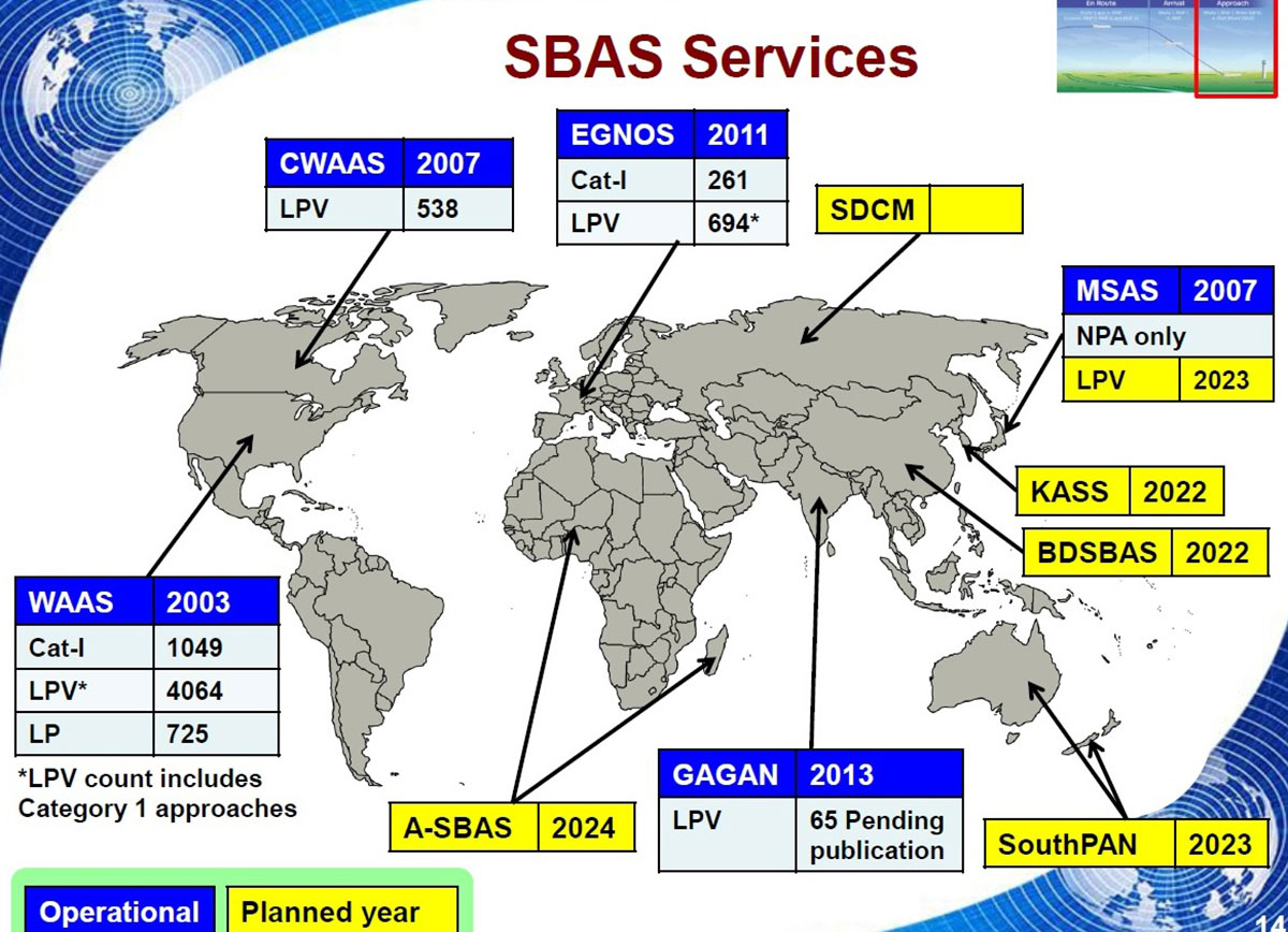
“In addition, we are working with developers of other SBAS around the globe to ensure they stay fully interoperable so for instance EGNOS-equipped aircraft can fly between continents on a seamless basis. Such interoperability, combined with the arrival of the other SBAS systems under development in other regions, will lead to a quasi-global worldwide safety-of-life service coverage in the year 2030.”
Operational and planned satellite-based augmentation systems (SBAS) around the globe. (Image: ESA)
Japan’s Quasi-Zenith Satellite System (QZSS) CLAS received a major enhancement on Nov. 30. QZSS CLAS (centimeter-level augmentation service) is the satellite-based nationwide open PPP-RTK service in Japan, providing centimeter positioning accuracy within one minute.
With the introduction of a new, highly efficient atmospheric correction message, the number of available satellites will be increased to 17 for those using CLAS. GPS, Galileo and QZS satellites in view will be corrected by the QZS L6 signal.
“The performance is expected be improved considerably, especially in urban areas,” said Rui Hirokawa, the deputy general manager, Space Systems Department of Mitsubishi Electric Corporation, Kamakura Works, in an email to GPS World.
Compact SSR — a highly efficient RTCM-compatible open specification for PPP/PPP-RTK — is applied to QZS CLAS. Compact SSR is accepted as a PPP-RTK standard in the 3GPP LTE positioning protocol (LPP) and the mobile communication standard for LTE/5G, with plans for it to be applied to the Galileo High-Accuracy Service (HAS).
Since July 1, CLAS has been broadcasting a trial signal compliant with IS-QZSS-L6-003 using the L6D signal of QZS-3, which increases the number of augmented satellites to a maximum of 17 for more stable positioning accuracy.
On Nov. 30 (JST), the official broadcast of the augmentation information began from all four QZS satellites (QZS-1, 2, 3 and 4).
To continue using CLAS after Nov. 30, it may be necessary to update the receiver’s F/W to comply with IS-QZSS-L6-003. Please contact the manufacturer of the CLAS receiver for further information. Read more in this National Space Policy Secretariat notice.
Service opens a new era of satellite navigation performance augmentation in the Africa and Indian Ocean Region
The Agency for Air Navigation Safety in Africa and Madagascar (ASECNA) has started to broadcast a satellite-based augmentation system (SBAS) signal over Africa and the Indian Ocean (AFI) region.
This is the first SBAS open service in this part of the world, according to Thales Alenia Space. The signal is broadcast via the NIGCOMSAT-1R satellite managed and operated by Nigerian Communications Satellite Ltd. under the Federal Ministry of Communications and Digital Economy of Nigeria.
The early open service is provided as part of the “SBAS for Africa & Indian Ocean” program, which pursues the autonomous provision over the continent of SBAS services to augment the performances of the satellite navigation constellations GPS and Galileo.
With improved accuracy to within a meter — and boosted integrity, availability and continuity of safety-related applications — the SBAS services will improve flight safety and efficiency in Africa. It will also benefit the economy in land, sea and rail transport areas, as well as mass-market applications, supporting user safety, cost-effectiveness and sustainable development.
Early Service Goals
The launched open service aims to carry-out technical trials, and to undertake with partner airlines field demonstrations for aircraft to demonstrate the benefits of the future operational safety-of-life SBAS services, expected in 2024. It will also include early precise point positioning (PPP) and emergency warning service, both to be demonstrated.
The signal in space is generated by a dedicated system testbed, developed as part of the “SBAS for Africa and Indian Ocean” preliminary design phase, financed by the European Union and awarded to a Thales Alenia Space joint venture between Thales (67%) and Leonardo (33%). The system prototype uses the SAGAIE reference station network deployed by CNES and ASECNA with the support of Thales Alenia Space.
The signal is broadcast via the SBAS payload on Nigcomsat-1R GEO satellite of the Nigerian Communications Satellite and an uplink station deployed in Abuja (Nigeria). It is compliant to the Standards and Recommended Practices of the International Civil Aviation Organisation, and the Minimum Operational Performance Standard developed by the RTCA (Radio Technical Commission for Aeronautics) organization. It will be visible in the whole Africa and Indian Ocean, up to the West Australian coast, and also in Europe.
“We are proud to be part of this ambitious program to provide satellite navigation services in the Africa and Indian Ocean region. The use of our geostationary communication satellite Nigcomsat-1R navigation payload to broadcast the first signal will be Africa’s premier contribution to SBAS as a regional satellite-based augmentation system for the continent,” said Abimbola Alale, MD/CEO of NIGCOMSAT Ltd.
“Our long-standing expertise acquired with the development of EGNOS SBAS in Europe and KASS SBAS in Korea combined with our new leading-edge satellite positioning technologies makes Thales Alenia Space the ideal partner to best support countries to implement their own SBAS efficiently. The equatorial region represents also a key engineering challenge for such a system due to difficult ionosphere conditions, for which Thales Alenia Space has developed a proven solution,” said Benoit Broudy, vice president of the Navigation business at Thales Alenia Space in France.
“The provision of the first African SBAS early service is a crucial major step forward in the development of satellite navigation in the AFI Region, and in the deployment of the ‘SBAS for Africa and Indian Ocean’ system, the navigation solution for Africa by Africa. It demonstrates the ambition and commitment of ASECNA to enhance air navigation safety for the benefit of the whole continent, in line with my vision for the unification of the African Sky,” stated Mohamed Moussa, director general of ASECNA.
About ASECNA
ASECNA is an international public organization. Its main mission is to provide air navigation services within an airspace of 16,500,000 square kilometers, divided into six flight information regions (F.I.R) as defined by the International Civil Aviation Organization (ICAO).
ASECNA also develops solutions for airport management, aviation infrastructure studies and construction, equipment maintenance, calibration of air navigation instruments and training for civil aviation staff.
Its 18 Member States are: Benin, Burkina Faso, Cameroon, Central African Republic, Comoros, Congo, Côte d’Ivoire, France, Gabon, Guinea Bissau, Equatorial Guinea, Madagascar, Mali, Mauritania, Niger, Senegal, Chad and Togo.