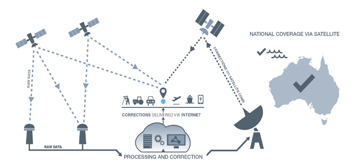
Geoscience Australia is seeking a prime contractor for a new satellite-based augmentation system (SBAS) that Australia and New Zealand have committed to implement.
The SBAS will improve position, navigation and timing (PNT) capabilities to end-users in Australia and New Zealand.
The system, which will be called the Southern Positioning Augmentation Network, will augment standard positioning capability provided by GPS and Galileo across all of Australia and New Zealand, with expected user applications in agriculture, construction, resources, utilities and other industries; with decimeter accuracy.
It will also support the aviation and road transport sectors, which have requirements for high-integrity positioning data with sub-meter level accuracy, Geoscience Australia said.
Full operational capability will require a number of satellite payloads in geostationary orbit needed to broadcast data to users. These may be hosted payloads rather than dedicated SBAS satellites, Geoscience Australia added.
This procurement process is administered by Geoscience Australia and is undertaken for the benefit of Geoscience Australia and its New Zealand counterpart, Land Information New Zealand.
The 6th Satellite-Based Augmentation Systems Interoperability Working Group (SBAS IWG) took place Feb. 5-7 in Delhi, India.
During the meeting, SBAS developers and operators were joined by users of the systems, with representatives of airlines, aircraft makers and avionics manufacturers. About 50 people in total attended the meeting.
“Satellite-based augmentation systems deliver the necessary accuracy, integrity, availability and service continuity for aircraft to be able to rely on them though all phases of flight, from cruising in the air to being guided down for landing,” said navigation engineer Didier Flament, head of the European Space Agency’s (ESA) EGNOS and SBAS division, representing ESA at the SBAS IWG.
The meeting covered the Southern Positioning Augmentation Network (SPAN), which had been born since IWG’s previous gathering six months ago. SPAN, a regional SBAS program, covers Australia and New Zealand.
The meeting also covered the progress of the four SBAS currently under definition or development: China’s Beidou SBAS, BDSBAS, represented by the China Satellite Navigation Office; South Korea’s KASS, represented by the Korea Aerospace Research Institute; the African and Indian Ocean SBAS, represented by the Agency for Aerial Navigation Safety in Africa and Madagascar; and the Russian Federation’s System for Differential Corrections and Monitoring (SDCM), represented by Russian Space Systems, RSS.
Current systems are mostly based around the U.S. GPS system (except for SDCM using Russia’s Glonass and BDSBAS using China’s Beidou) but plans are being laid to move to a dual-frequency, multi-constellation version making use of Europe’s Galileo, China’s Beidou and Russia’s Glonass satnav systems later this decade, IWG said.
Finally, the meeting touched on SBAS research and development, including applying SBAS to Europe’s railways.
Today, there are 10 satellite-based augmentation systems for satnav that are either in operation or active development, IWG added. The group is working to ensure that the future evolutions of all these systems will operate on a similar basis with common technical requirements, allowing the easy transition of continent-crossing air traffic from one system to another.
Australia and New Zealand are partnering to roll out satellite technology that will be able to pinpoint a location on Earth to within 10 centimeters, unlocking more than $7.5 billion in benefits for industries in both countries.
Prime Minister Scott Morrison and New Zealand’s Prime Minister Jacinda Ardern committed jointly to implement a satellite-based augmentation system (SBAS), to operate across Australia and New Zealand, at the Australia-New Zealand leaders’ meeting held Feb. 28.
The system will improve the accuracy of GPS and other positioning services from the current five to 10 meters to as little as 10 centimeters across Australia and New Zealand without the need for mobile or internet coverage.
The new project follows 18 months of successful trials that tested 27 projects across a range of industries. It will be delivered by Geoscience Australia and Land Information New Zealand under the joint science research and innovation treaty.
Minister for Resources, Water and Northern Australia Keith Pitt said the project, to be operating by 2023, will have significant benefits to a range of industry sectors including mining, agriculture and transport.
“We welcome New Zealand’s commitment to join Australia in rolling out this exciting new technology, which will deliver substantial economic benefits for both countries,” Minister Pitt said.
“An independent analysis by Ernst and Young (EY) has found improved positioning technology will deliver more than $6.2 billion in benefits for Australia, and more than $1.4 billion in benefits for New Zealand, over the next 30 years.
“Trial projects have also found the system can make our roads and rail systems much safer, and can improve the way farmers manage their land, crops and livestock. For the resources sector, the technology can track vehicles and improve site surveys to enable precise extraction of deposits.”
Industry, Science and Technology Minister Karen Andrews said the project will complement Australia’s other investments in space to drive economic growth and create new jobs.
“The Morrison Government is backing these types of technologies because of the positive impact they have on the lives of everyday Australians — from the discoveries that make life easier through to growing industries that create high-value jobs,” Minister Andrews said.
“Many industries stand to benefit from this technology. It could help improve safety and efficiency in aviation and shipping and will be crucial to the development of autonomous vehicles.
“This work also supports our government’s broader commitment to triple the size of the space sector to $12 billion and an extra 20,000 new jobs by 2030.”
A Eutelsat communications satellite launched Oct. 9 carried a payload for the European GNSS Agency (GSA) called GEO-3. GEO-3 is a geostationary satellite designed to augment GNSS signals.
The EGNOS payload, manufactured by Airbus Defence and Space, will hone the accuracy of satellite navigation signals over Europe for use in aviation, maritime and other industries as part of the European Geostationary Navigation Overlay System (EGNOS).
The Eutelsat-5 West B satellite also hosts a payload that will enable service continuity for television broadcasting in Europe and North Africa.
The GSA signed a contract in March 2017 with Eutelsat Communications for the development, integration and operation of the next-generation GEO-3 EGNOS payload.
EGNOS operational messages are broadcast via navigation payloads on-board two GEO satellites, including an Inmarsat-3F2 satellite that is fast approaching end-of-life. The GEO-3 services replenish the EGNOS SBAS payloads, guaranteeing EGNOS availability and supporting the transition to the dual-frequency multi-constellation-capable EGNOS V3.
Eutelsat will also develop two redundant RF ground stations to uplink the EGNOS message to the payload. It will also host EGNOS’ Navigation Land Earth Stations (NLES) in Rambouillet, France, and Cagliari, Italy, both of which will be co-located and connected to the RF ground stations.
Proton-powered launch
The satellite was carried aloft on a Proton rocket along with a second satellite, the Mission Extension Vehicle-1 for Northrop Grumman subsidiary SpaceLogistics, designed to service satellites. Both spacecraft were built by Northrop Grumman.
The Proton rocket lifted off at 6:18 a.m. Eastern Time from Russia’s Baikonur Cosmodrome in Kazakhstan. Its two passengers separated from the rocket 16 hours later in a supersynchronous transfer orbit.
Eutelsat-5 West B is a replacement for the 17-year-old Eutelsat-5 West A satellite.
The application was developed with special interest paid to raw data recording and NTRIP service connection.
With the SXblue ToolBox iOS application, the user can analyze the position data provided by the SXblue receiver, as well as location metadata.
More important for SXblue clients, the application can record, save and transfer raw data from the GNSS receiver, thereby allowing post-processing activities. The application also acts as a NTRIP client, capable of connecting to a NTRIP server for real-time kinematic (RTK) corrections, and thus allows the receiver to issue very accurate location information.
Receiver configuration is easy through the application, with the ability to set up and save user-defined commands for subsequent use. The settings include constellation to be used, differential source, NTRIP login credentials list and more.
In addition, the iOS application includes a series of audible and visual alarms that are user-configurable to determine the thresholds of information provided by the SXblue GNSS receiver.
The main features of the iOS SXblue ToolBox application are:
Display of location information and quality of positioning data
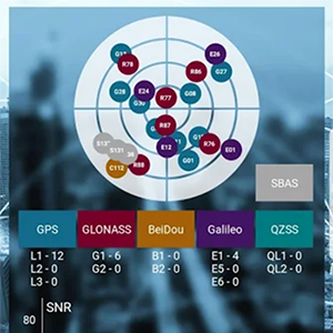
Skyplot of all-in-view constellations: GPS, GLONASS, Galileo BeiDou, QZSS, SBAS
Recording of raw data and data transfer
NTRIP/DIP client to receive RTK corrections
Terminal to send commands and view the output data of the SXblue device
Audible and visual alarms
Activation of options and licenses via the application.
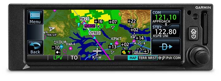
The GNC 355 is a GPS navigator with localizer performance with vertical (LPV) approach guidance and a built-in communications radio. (Photo: Garmin)
Garmin International Inc. has launched the GNC 355 — a GPS navigator with Localizer Performance with Vertical (LPV) approach guidance and built-in communications radio.
With the GNC 355, pilots can take advantage of the benefits of WAAS/SBAS GPS guidance, while also incorporating a modern comm radio into their existing avionics stack.
Intended for Class I/II aircraft that weigh 6,000 lbs./2,721 kg. or less, as well as experimental/amateur-built (EAB) aircraft, the GNC 355 Supplemental Type Certification (STC) is imminent and will be available in August for more than 700 aircraft makes/models.
“Based on the popularity of legacy products like the GX 60 and the GNC 250/300XL, as well as customer excitement for our new GPS 175 and GNX 375, we’re pleased to bring the GNC 355 to market,” said Carl Wolf, Garmin vice president of aviation sales and marketing. “The GNC 355 gives value-minded customers a simple upgrade path to a GPS navigator with a number of capabilities including WAAS/LPV approach guidance, wireless connectivity, a modern Comm radio, and with its standard mark-width form factor, pilots can easily add the GNC 355 without overhauling the panel of their aircraft.”
Aircraft owners can incorporate the GNC 355 into an existing avionics stack because of its standard 6.25-inch wide by 2-inch tall design. A vibrant, colorful and responsive touchscreen display boasts a familiar Garmin user experience, while a dual concentric knob and home button offer added versatility when interfacing with the touchscreen.
The user interface has been optimized for the screen size of the display, while also retaining a familiar menu structure similar to other Garmin products. Pilots can quickly access direct-to functionality, moving map, flight plan, nearest, procedures, waypoint and terrain pages, as well as frequency information using the touchscreen, and create customizable data fields and shortcuts for quick, one-touch access to important information.
Fully WAAS/SBAS IFR-approach-capable, the GNC 355 gives pilots the benefit of flying LPV, as well as Area Navigation (RNAV) approaches. Many approaches offer vertical approach guidance as low as 200-feet above ground level (AGL).
Pilots can also leverage the touchscreen and moving map to generate customized holding patterns over an existing fix in the navigation database or over a user-defined waypoint and easily insert it into a flight plan. Visual approaches are also available within the GNC 355 and provide lateral and vertical approach guidance in visual flight conditions.
Two versions, the GNC 355 and GNC 355A, are available with 25 kHz and 8.33 kHz frequency channel spacing respectively. Using the internal frequency database, airport, weather, Air Route Traffic Control Center (ARTCC) and Flight Service Station (FSS) frequencies are easy to find and can be loaded to the standby position by selecting the frequency from the airport information page. Recent, nearby and saved frequencies also offer easy access to frequency information. For example, with built-in standby frequency monitoring, pilots can listen to ATIS while monitoring tower frequency simultaneously. The airport identifier and frequency type are also displayed below the frequency so pilots can communicate with confidence.
An array of interface options includes the G3X Touch flight display for experimental and certificated aircraft, the G5 electronic flight instrument, the GFC 500 and GFC 600 autopilots, as well as select third-party autopilots. Course deviation and roll steering outputs can also be coupled to the GFC 500/GFC 600 autopilots and select third-party autopilots so procedures such as holds, radius-to-fix (RF) legs and missed approaches may be flown using the autopilot. Aircraft owners can also retain many of their existing flight instruments, audio panels and many legacy CDI/EHSI indicators such as the KI 208/209 products.
Additional interface options include pairing the GNC 355 with a dual-link Garmin Automatic Dependent Surveillance-Broadcast (ADS-B) solution, such as the GTX 345 or GDL 88. When paired with these products, the GNC 355 is capable of displaying subscription-free Flight Information Service-Broadcast (FIS-B) weather and ADS-B traffic targets, which includes patented TargetTrend and TerminalTraffic.
Wireless Connext devices running the Garmin Pilot and FltPlan Go applications. Pilots can also use the Flight Stream 510 to access the wireless benefits of Garmin’s Database Concierge, which uploads aviation database information from the Garmin Pilot app to the GNC 355 in minutes.
The GNC 355 provides a number of additional benefits, including graphical flight plan editing, allowing pilots to more easily edit their flight plan based on an ATC amendment or weather. Features such as FastFind simplify flight plan entry by applying predictive logic to suggest airports and waypoints using current GPS location, while Smart Airspace makes it easier to identify pertinent airspace on the moving map.
The addition of SafeTaxi airport diagrams displays runways, taxiways, Fixed Based Operators (FBOs), hangars and more relative to the aircraft’s location on the airport surface.
The GNC 355 and GNC 355A can be purchased through the Garmin Authorized Dealer network at that time starting at a list price of $6,9951 and $7,6951 respectively.
European Union Aviation Safety Agency (EASA) validation is expected at a later date.
A free GNC 355 trainer app is also available for download on Apple mobile devices, which allows customers to explore the feature set.
Garmin International Inc., a unit of Garmin Ltd., has launched the GPS 3000, a high-integrity GPS position sensor that interfaces to existing avionics to help meet Automatic Dependent Surveillance-Broadcast (ADS-B) Out requirements.
Also, targeting the air transport and defense markets, the GPS 3000 is designed as a WAAS/SBAS position source for select Flight Management Systems (FMS).
Aircraft that are eligible to utilize the GPS 3000 as an ADS-B position source include the Embraer E135/E145 and the Legacy 600/650. Supplemental Type Certification (STC) for the GPS 3000 in these aircraft is currently available from FTI Engineering, in cooperation with Atlas Air Service in Germany, and can be installed throughout the entire Garmin dealer network.
“Garmin continues to lead the industry with the most fielded ADS-B solutions that span all segments of aviation, including a wide-range of commercial, defense, regional and business aircraft,” said Carl Wolf, vice president of aviation sales and marketing. “We are thrilled to provide these aircraft with a solution that is cost-effective and is an easy to install alternative to the existing avionics manufacturer’s service bulletin.”
A rugged, stand-alone and certified Wide Area Augmentation System (WAAS)/Satellite-Based Augmentation System (SBAS) GPS, the GPS 3000 meets DO-160 and DO-178B standards and is designed specifically for the harsh environmental conditions encountered by commercial aircraft.
This compact and remote-mount solution utilizes enhanced WAAS/SBAS GPS satellite signals to provide precise position data through a standard interface. It also meets applicable high-integrity ADS-B position source standards, including TSO-C145d Class 3, the company said.
The GPS 3000 is also designed to interface with select FMS to support GPS guidance throughout terminal, enroute and approach navigation. When configured appropriately, the GPS 3000 is capable of providing position information to an existing FMS to meet requirements for Required Navigation Performance (RNP) and can support GPS-based vertical approach navigation, such as Localizer Performance with Vertical (LPV) approach guidance.
European Aviation Safety Agency (EASA) STC of the GPS 3000 in the Embraer E135/E145 and Legacy 600/650 is available from FTI Engineering, in cooperation with Atlas Air Service, as well as Garmin dealers. FAA validation of the STC is pending.
Skydel Solutions has updated its SDX GNSS simulator to version 19.1. The new version adds Galileo AltBOC signal generation, new atmospheric errors, SBAS improvements and SV antenna patterns.
Galileo AltBOC. SDX now supports Galileo AltBOC as a new GNSS signal type. Current SDX users licensed with the Galileo E5 signal will be able to generate 8 Phase Shift Keying (8-PSK) constant envelope AltBOC after upgrading to SDX 19.1.
The signal can be generated by selecting both Galileo E5a and E5b in the output – signal selection panel.
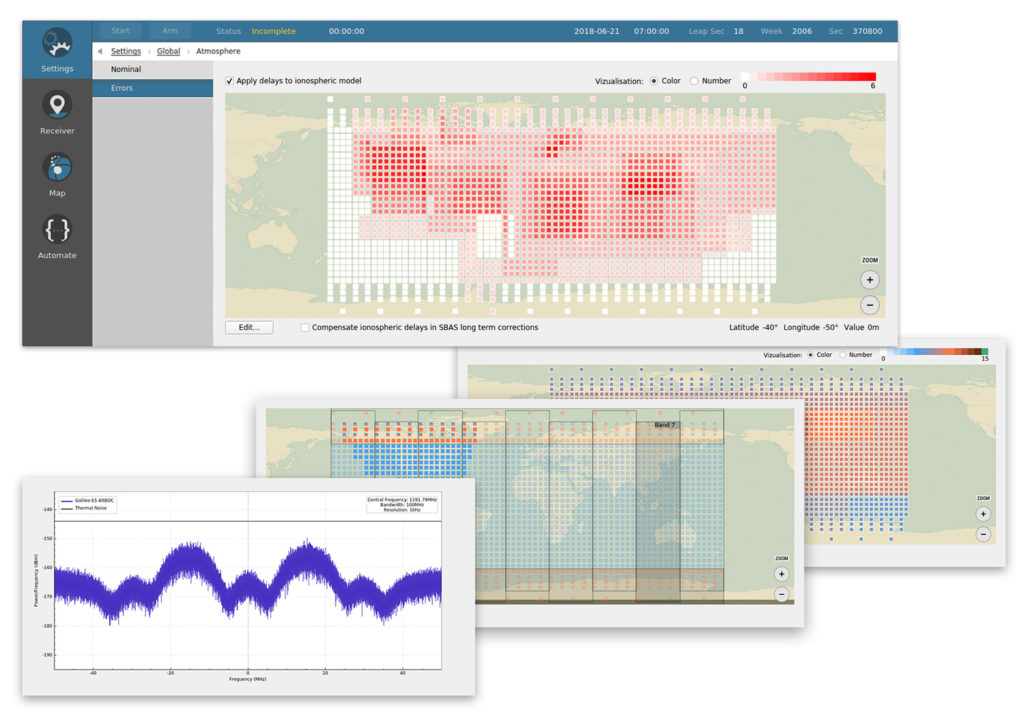
A montage of screenshots showing the various updates. (Image: Skydel)
Atmospheric Delays and Improvements to SBAS. Version 19.1 adds a new error type to all SDX users: atmospheric delays. These errors can be compensated with SBAS for SDX licensees with the SBAS option installed. The SBAS message now broadcasts ionospheric error corrections.
Three new interfaces help create, manage and use these error values in simulation scenarios.
Atmospheric Errors (Settings : Global). This panel enables users to review and edit the ionospheric delay values for any SBAS Ionospheric Grid Points (IGPs) . The map view can be navigated (pan and zoom) much like the map panel of the simulation. The edit button brings up an IGP editor used to assign the points values or increase their current value by a set amount.
Since the number of points in the grid is fairly large, the user interface works with a selection of points, allowing users to add or remove the current selection in order to quickly work your way around the whole map.
Atmospheric errors are available to all SDX licensees with the 19.1 upgrade.
Ionospheric Masks (Settings : SBAS). SDX users with the SBAS option can use this new interface to assign the true/false value for each point of the different SBAS bands, per service provider. It reuses most of the paradigm of the aforementioned atmospheric error pane.
Ionospheric GIVE Indicators (Settings : SBAS). Using a similar map interface as the two previous panels, the GIVEI (GIVE Indicators) panel enables you to provide the GIVE Indicator values for each IGP that is configured in the mask, per service provider.
The grids created or modified with these new options can all be saved and imported back into future SDX scenarios.
New GNSS Satellite Antenna Patterns. Also new in SDX 19.1 is the possibility to add user-defined antenna patterns to GNSS satellites. These new antenna pattern options show SDX’s flexibility by allowing any user-defined antenna pattern to be applied to any satellites in any GNSS constellation.
This can prove especially useful for scientists and engineers working with space vehicles, due to their unusual orientation when compared to surface vehicles. High-Earth-orbiting spacecraft benefit from the side lobes of GNSS satellites to improve navigation performance. In fact, when tracking the signal from side lobes, the number of visible satellites is drastically increased, and the precision can improve from the kilometer to the meter level.
In addition, the new antenna patterns can be a potent tool in the context of research projects that experiment with user-defined GNSS SV Antennas.
SV antenna patterns in SDX. SDX now allows you to create, define, and manage antenna patterns for GNSS satellites using an interface very similar to the one we introduced for vehicles in SDX 18.10. As with that release, the various patterns are organized into antenna models that can be named, managed, exported, and reimported back into other simulation scenarios.
The user interface has also been improved. Read more about the changes in Skydel’s blog.
By Juan Vázquez, Elisabet Lacarra, Jorge Morán and Miguel A. Sánchez, ESSP SAS, and Julian Rioja and Jimmy Bruzual, Topcon Agriculture
The European Geostationary Navigation Overlay Service (EGNOS), a satellite-based augmentation system (SBAS), provides corrections and integrity information to GPS signals over Europe and is fully interoperable with other SBAS such as North America’s WAAS. Among its services is the internet-based EGNOS Data Access Service (EDAS).
EDAS gathers raw data from GPS, GLONASS and EGNOS GEO satellites collected by receivers at approximately 40 EGNOS ground stations distributed over Europe and North Africa. EDAS reformats and disseminates GNSS data in real time and through an FTP archive to EDAS users and service providers.
Additionally, EDAS provides differential GNSS corrections to the GPS and GLONASS satellites in view by the EGNOS system network through its Ntrip service.
The tests summarized in this article focused on the EDAS Ntrip Service, which can be used for differential positioning. An earlier test near Seville, Spain, concluded that these corrections could support pass-to-pass accuracies in the order of 20 centimeters in a consistent manner and with a high degree of repeatability.
To assess EDAS performance validity for agriculture applications, two additional tests were done in Lisbon, Portugal, and York, UK. These locations provide diversity with respect to the Seville test, especially in terms of distance from the farm to the selected EGNOS reference station (≈320 km in York and 40 km in Lisbon, versus the 110 km baseline of the test in Seville) and also geographically. In all tests, a real-time kinematic solution operated in parallel to the EDAS DGPS solution to provide the required reference for the post-processing of the recorded data. Nine different runs with a total of 78 passes were performed in these two campaigns.
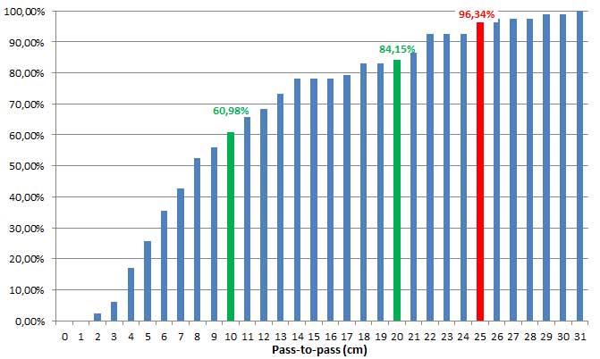
Considering the results from the three tests, the pass-to-pass accuracy supported by EDAS DGPS corrections was below 10 cm for more than 60% of passes and below 20 cm for more than 85 percent of the passes. These figures exceed the earlier results and confirm that EDAS DGPS corrections can deliver pass-to-pass accuracies in the order of 10 to 20 cm in a consistent manner.
Cumulative distribution of P2P accuracy, in centimeters. (Chart: Topcon)
The stability of the results and the very good pass-to-pass accuracy levels observed in the York scenario, where baselines larger than 300 km were tested, deserve highlighting. For grain and dry soil cultivation, at least 1 meter (95th percentile) of absolute horizontal accuracy is required. It can be assumed that, within the area where EDAS DGPS supports sub-meter horizontal accuracies (up to 260 km from the selected EGNOS station, according to previous studies), EDAS DGPS corrections can also support pass-to-pass accuracies in the order of 10-20 cm.
Such performance levels are considered to be appropriate for most grain farm operations. In particular, the observed performance is sufficient to support the following precision agriculture applications:
Features include enhanced ADS-B, SBAS and georeferenced charts.
Collins Aerospace’s Pro Line Fusion avionics upgrade for Pro Line 4-equipped Bombardier Challenger 604 series aircraft has been certified by the U.S. Federal Aviation Administration (FAA).
Working closely with Bombardier as the original aircraft manufacturer and Nextant Aerospace as the installation design certification lead, this sole all-in-one solution complies with pending mandates while modernizing the flight experience for pilots.
The Pro Line Fusion upgrade enhances the operational capabilities of the Challenger 604 aircraft to a similar level as that of the Challenger 605 and Challenger 650 jets equipped with Collins Pro Line 21 Advanced, while providing Challenger 604 operators with a solution to meet future regulatory requirements.
Among these enhancements, the upgrade replaces the factory-installed CRT displays with three 14.1-inch widescreen LCD displays with configurable windows. Features designed to improve situational awareness and reduce pilot workload for Bombardier Challenger 604 aircraft owners include:
A fully loaded package of baseline equipment for operation in modernizing global airspace — beyond ADS-B mandate compliance, offering SBAS-capable GNSS, localizer performance with vertical guidance (LPV) approaches, radius-to-fix (RF) legs and more
Geo-referenced electronic navigation charts that display own-ship aircraft position
The Challenger 604 Pro Line Fusion retrofit solution, which is already available for several Beechcraft King Air and Cessna Citation CJ aircraft, is part of our ongoing effort to provide owners with modern technology, enhanced situational awareness and compliance with airspace mandates,” said Christophe Blanc, vice president and general manager, business and regional systems for Collins Aerospace. “The Challenger 604 business jet is a highly-valued, long-haul aircraft that will be able to continue flying well into the future with this upgrade.”
The upgrade is available exclusively throughout Bombardier’s extensive network of service centers and Nextant Aerospace.
NovAtel has been awarded a contract from the United States Federal Aviation Administration (FAA) to design, produce and deliver 40 next-generation Ground Uplink Station (GUS) Signal Generators to support the FAA’s safety-of-life WAAS navigation service. The service provides safety-critical infrastructure for the North American aviation navigation network.
GUS signal generator. (Photo: NovAtel)
The contract also includes ongoing engineering support services for NovAtel’s complete portfolio of satellite-based augmentation system (SBAS) products deployed by the FAA, including the WAAS G-III reference receiver platform.
The FAA has relied on NovAtel’s safety-critical SBAS technology for more than 20 years, starting with NovAtel’s first-generation WAAS reference receiver that was created in the 1990s.
Developed by the FAA, the WAAS network is a safety-critical navigation aid that allows aircraft to use GPS for all phases of flight. Every time an aircraft takes off or lands within the WAAS coverage area, NovAtel technology is generating and processing data that allows aviators to make precision approaches to any airport.
Since the program’s inception, NovAtel has provided the FAA with technology that delivers high-precision GPS receiver measurements and navigation information from WAAS Reference Stations and the GUS infrastructure.
Under this new contract, NovAtel will help modernize the WAAS network by upgrading and extending support for the network’s GUS infrastructure. The next-generation of GUS signal generators, which are designed specifically for SBAS ground uplink systems, will include independent L1 and L5 signal paths to precisely control the frequency and phase of L1 and L5 code and carrier for dual-frequency SBAS.
A GUS receiver system based on the WAAS G-III receiver platform will also be released along with the signal generator to complete the modernized GUS control loop.
“We have a long history with the FAA and have worked very closely with the WAAS program team to develop multiple-generations of SBAS infrastructure,” said Jonathan Auld, vice president of engineering and safety critical systems at NovAtel. “NovAtel remains committed to supporting the FAA and their safety of life WAAS service and we are excited to deliver this critical next-generation technology for SBAS modernization.”
Space Based Augmentation Systems (SBAS) – known in North America as the Federal Aviation Administration’s (FAA’s) Wide Area Augmentation System (WAAS) – have been fully operational in one form or another for several years. The FAA’s incremental improvements to integrity, accuracy and reliability in WAAS have brought the system to a point where we have precision en-route navigation for aircraft, and we can also land aircraft using WAAS signals at thousands of airports in the US and in Canada.
Why not Mexico, which also benefits from the same WAAS coverage? More on that later, as we piece together the many parts of the complex SBAS mosaic.
SBAS precision approach coverage, May 2016. Graphic: FAA Tech Center, Lockheed Martin, GMV
Europe benefits from high-accuracy en-route navigation, and there are also hundreds of operational approaches using the European Geostationary Navigation Overlay Service (EGNOS) SBAS.
In India, the GPS Aided Geo-Augmented Navigation (GAGAN) system provides accurate en-route navigation and approach capability. However, ionospheric disturbance may limit some aspects of performance.
Japan established the Multi-functional Satellite Augmentation System (MSAS) SBAS, and has benefited from improved en-route navigation, but it’s possible that the more limited geographic distribution of GPS ground reference stations has restricted improvements to approach capabilities.
But what happened to the International Civil Aviation Organization (ICAO) concept from 2007, supported by all the ‘aviation-going’ countries of the world, that SBAS would evolve and eventually multiple national systems would provide coverage around the rest of the world, maybe even by 2016?
Countries in Asia, South America, Africa and the continent of Australia all appear to have looked closely into establishing their own SBAS, but nothing seems to have come out of these investigations. Technical issues, cost, and political obstacles have all hindered global SBAS progress.
The ionospheric challenge. Graphic: GMV and Lockheed-Martin
Technical Issues. Ionospheric scintillation problems around the Equator seem to be at the root of most technical problems for SBAS. Getting to the required level of probable, bounded system error is hugely difficult. The iono disturbance ‘blob’ follows the sun around the Equator and wipes out any chance of satisfactory system performance when it passes over Equatorial countries.
As total electron count (TEC) increases, the ionospheric grid, which most SBAS use to predict ionospheric variation across their geographic area between fixed reference stations, well, it just doesn’t work anymore.
Cost. The capital cost of building a satellite-based augmentation system and the on-going cost of maintaining a bunch of geographically distributed reference sites, building and launching GEO satellites or renting transponders on someone else’s orbiting asset, establishing, operating and maintaining redundant uplink stations, redundant terrestrial data links, and setting up control systems that collect and create the SBAS uplink message — it all adds up. Millions and maybe even billions of dollars or equivalent, in total, have been spent by those select countries who could afford their own SBAS. Others named above have lesser financial resources upon which to draw.
Political Obstacles. One of the trickiest issues is sovereignty: the need for a country to control its own navigation and landing system. This has likely been the source of most resistance to more SBAS systems being set up and shared by bordering countries around the world.
For a large number of smaller countries, SBAS would only make sense if it was shared across a number of neighboring countries, but that means relinquishing sovereignty to some degree. In several regions of the world a number of geographically adjacent countries don’t particularly like each other, never mind thinking of such sharing/collaboration.
National sovereignty, by the way, isone of the main reasons that existing satellite navigation systems underpinning SBAS, such as Galileo, GLONASS, IRNSS (now NAVIC), QZSS and of course BeiDou have all been put in place.
Another problem with potential SBAS sharing across adjacent countries stems from responsibility for liability. Should something not work and an accident ensues from such a malfunction, who’s liable? Mexico seems to have adopted the view that since the US provides WAAS on what could be called an ‘as-is’ basis, then the potential liability issue seems to trump using the system.
Solutions? Technical issues with the ionosphere may soon be resolved by using dual-frequency L1/L5 airborne receivers that directly calculate their own ionospheric corrections, rather than using the computed SBAS iono grid. If we add in dual-frequency E1/E5a signals from Galileo, things start to get even better. New requirements and prototype equipment are already being developed for dual frequency multi-constellation airborne receivers. Airbus anticipates equipping aircraft with such receivers around 2025. Could this solve the SBAS technical issue for Equatorial countries?
ARINC (now a UTC/Rockwell Collins company) and SITA (in Europe) have been providing commercial aircraft with operational communications services on a pay-for-use basis for a number of years, and this is notarized as an accepted means of compliance within ICAO policy/requirements:
From ICAO Doc. 9161, Sec. 3.99: “A group of states or a regional organization might also undertake to operate the augmentation satellite service required, either by themselves or by contracting a commercial or government organization to do so on their behalf.”
ARINC en-route coverage. Graphic: ARINC
Aireon has partnered with NAV CANADA, the Irish Aviation Authority (IAA), Enav, NATS and Naviair, as well as Iridium Communications and Harris Corporation to provide real time ADS-B data (GPS position output from aircraft) to air-traffic control providers. Aireon’s payloads on the new Iridium NEXT Low-Earth Orbit (LEO) satellite constellation will receive aircraft ADS-B messages and relay them to Air Traffic Controllers in real-time.
There are 66 Iridium NEXT satellites in operation, with significant overlap and redundancy built into the system to enable this safety-of-life service to be provided on a pay-for-use basis to the aviation industry. We could at last know the location of every suitably equipped aircraft in the air, in almost real-time. The ICAO requirement is for an update rate of 15 minutes.
Inmarsat ADS-C is a similar service available to aircraft on a contracted, pay-for-use basis via Inmarsat GEO satellites.
Market Solutions. If a substantial company showed up with a worldwide distributed SBAS solution and offered it on a fee for service basis, why wouldn’t countries that are already accustomed to ARINC and SITA pay-for-use communications? The Aireon international aircraft tracking system, to be provided on the same basis, adds to the credibility of such a pay-for-use service.
So why wouldn’t these accepted services demonstrate to those countries concerned about control and national sovereignty that an SBAS service could be provided on this basis?
The liability for provision of service sits with the providers, so user countries/airlines would have someone to turn to about liability issues, and there presumably could be contract terms to provide system performance guarantees.
No huge capital costs, no system to construct, nor staff to operate or maintain, and yet a level of control similar to that which has been around for commercial aircraft communications for decades.
Would this be of interest to countries that have not yet jumped on the SBAS bandwagon? A definite ‘maybe,’ we could imagine? What’s not to like?
The punch line to all this is that Lockheed Martin and GMV (Spain) have teamed to challenge these non-SBAS countries with a solution which may appeal.
Uralla reference test site. Photo: Lockheed-Martin
To present convincing evidence that it would work, a dual frequency GPS (L1/L2) + Galileo (E1/E5a) reference site has been set up in collaboration with Geoscience Australia and Land Information New Zealand. The reference site is located at Uralla, New South Wales on Australia’s East Coast, where it gathers data demonstrating bounded errors within the operational range which could enable GNSS approach capability.
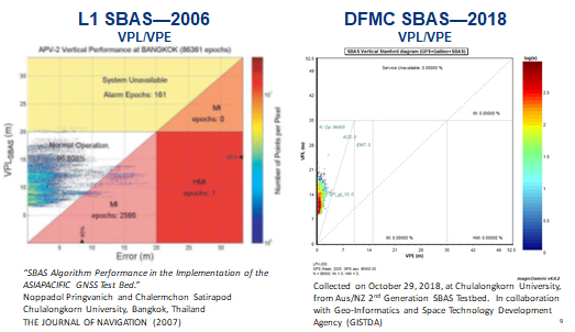
L1 (2006) vs. DFMC (2018) SBAS at Bangkok. Graphic: Lockheed-Martin, GMV
Another test site in Bangkok, Thailand has demonstrated that existing L1-only SBAS in this area cannot manage this performance (all current SBAS are L1 only), but that with dual-frequency multi-constellation (DFMC) GPS L1/L2+Galileo E1/E5a, the required performance limits could be met.
Lockheed Martin has also been using the Uralla uplink site to test the uplink and downlink of dual-frequency SBAS-like test messages.
The Moral of the Story. There are no miracles as yet, but interest in the pay-as-you-go SBAS concept appears to be growing, and the LM/GMV team continues to work to bring their approach to market.
A large number of countries could well benefit from the high accuracy, integrity and continuity of SBAS service if this all comes together.