Category: Mapping

  • CHC Navigation introduces LT700H GNSS RTK tablet

    CHC Navigation introduces LT700H GNSS RTK tablet

    CHC Navigation has launched its LT700H RTK Android tablet, designed to increase efficiency and productivity of the mobile field workforce in applications requiring centimeter-to-decimeter positioning accuracy.

    Photo: CHC Navigation
    Photo: CHC Navigation

    Portable, rugged and versatile, the LT700H enables precision GIS data collection, forensic mapping, construction site layout, environmental surveys, landscaping and earthmoving jobs.

    Powered by 184-channel high-performance GPS, GLONASS, Galileo and BeiDou module and a superior tracking GNSS helical antenna, the LT700H provides position availability in demanding environments. Its integrated 4G modem ensures seamless communication from field-to-office and robust connectivity to GNSS real-time kinematic (RTK) networks corrections.

    “With the LT700H RTK Tablet, we are offering a professional and accurate GNSS solution to any mobile applications requiring high-portability,” said George Zhao, CEO of CHC Navigation. “The LT700H enables further use of GNSS technology, from single operator to companies with large field crew.”

    Combined with CHCNAV Landstar 7 field data-collection software, the LT700H has a vibrant 8-inch IPS sunlight-viewable screen that perfectly displays GIS data tables, vector and raster maps or high-resolution pictures.

    The LT700H Google GMS certification guarantees compatibility with any common GIS and mapping Android applications.

  • Eos releases underground infrastructure mapping solution for Collector for ArcGIS

    Eos releases underground infrastructure mapping solution for Collector for ArcGIS

    Eos Locate for Collector for ArcGIS enables utilities to map buried assets with submeter or centimeter accuracy

    A worker using an Arrow receiver and vLoc from Vivax Metrotech. (Photo: Eos Positioning)
    A worker using an Arrow receiver and vLoc from Vivax Metrotech. (Photo: Eos Positioning)

    Eos Positioning Systems Inc.  (Eos) has released its underground utility asset-mapping solution: Eos Locate for Collector for ArcGIS.

    Eos Locate for Collector combines three core technologies: Eos Arrow GNSS receivers, Esri Collector, and the Vivax-Metrotech vLoc Series of locator devices.

    With Eos Locate for Collector, one field worker can collect both GNSS locations and locator data (such as depth below cover) for any buried asset including water, sewer, electric, cable, gas, fiber infrastructure and more. They can do so quickly, accurately and without the need for any additional field or office support.

    “We are giving our Arrow GNSS customers a solution today that allows them to combine both locator data and high-accuracy locations in web maps,” Eos CTO Jean-Yves Lauture said. “This greatly simplifies their workflow by allowing one person to do underground locates and GIS mapping simultaneously.”

    “This is a big step forward for utility organizations who need to gain better visibility of their infrastructure,” said Doug Morgenthaler, Esri program manager. “With today’s technology, utilities can already see where new assets are being put in the ground. The challenge historically has been figuring out where existing assets are.”

    Eos Locate for Collector not only streamlines underground-asset mapping, but also improves office production times. It eliminates the need to manually combine datasets from the locator and GPS devices within ArcGIS.

    “Seeing all that information from utility locators and GPS receivers packaged directly into a GIS application is exceptional,” Vivax-Metrotech Eastern Regional Sales Manager Kelvin Cherrington said. “This solution will help utilities create maps of their underground assets with a much more modern and efficient methodology.”

    Indiana American Water Early Adoption

    Earlier this year, Indiana American Water approached Eos to seek a solution that consolidated their utility-locate workflow with their Arrow and Collector field work.

    “We had the manpower to put paint down,” said Todd Chapman, Indiana American Water Senior GIS Analyst. “But we would need to hire another person to map the locations with our Arrow Gold GNSS receivers.”

    Chapman estimates Eos Locate for Collector will cut their field time in half as well as enable the creation of extremely accurate buried-infrastructure maps in ArcGIS.

    “Previously, we were seeing that our old water mains could be off by up to 20 feet,” Chapman said. “With the new Eos Locate for Collector, we’re seeing that it’s accurate to under an inch.”

    The initial release of Eos Locate for Collector runs on Apple’s iOS iPhones and iPads and supports the vLoc Series from Vivax Metrotech. Future releases of Eos Locate for Collector will support additional locator models including the vScan series.

    With accurate digital twins of their buried infrastructure, utilities across sectors can expect improvements to safety, damage prevention, field efficiency and regulatory compliance.

    “Not only does this mean quicker responses to 811 tickets and fewer liabilities during field digs,” Lauture said. “But it also constitutes a major step forward toward the highly efficient future of 3D asset management and viable augmented-reality workflows.”

  • SimActive used to determine financial assistance after Hurricane Dorian

    SimActive used to determine financial assistance after Hurricane Dorian

    Photo: SimActive
    Photo: SimActive

    SimActive Inc., a developer of photogrammetry software, announces that its Correlator3D software has been used by Air Data Solutions (ADS) in Florida to determine financial assistance following Hurricane Dorian.

    Aerial imagery was collected before the storm for pre-hurricane assessment and after for damage analysis.

    A Phase One 100MP aerial camera owned by ADS was flown to gather high-resolution images of the affected areas. The data was then processed by SimActive software to create mosaics of orthophotos.

    The resulting geospatial data helped government authorities to calculate recovery aid funds.

    “We have been impressed by the accuracy and speed of Correlator3D to support such a time-critical mission,” said Don Cummins, President of ADS. “Combined with a high-end aerial sensor, SimActive provides the best tool for emergency response.”

    Air Data Solutions is an aerial, terrestrial, and aquatic data collection and modeling company.

  • Geneq launches SXPad 1500 rugged data collector

    Geneq launches SXPad 1500 rugged data collector

    The New Handheld Is Designed for Data Collection for Land Surveying and Geospatial Information Systems (GIS)

    Photo: Geneq
    Photo: Geneq

    Geneq Inc. has added a new data collector to its SXPad product line. The rugged SXPad 1500 data collector features a full alphanumeric QWERTY keypad and long-range Bluetooth, and was designed to meet the rigorous IP67 standard to deal with challenging field conditions.

    The SXPad 1500 and its 5-inch sunlight-readable touchscreen can be connected to any GNSS receiver or compatible robotic total station to ensure the success of all survey projects.

    Driven by a 1-GHz processor and the Windows Mobile 6.5 operating system, the field collector is a high-performance device designed to provide the power needed to work with maps and large data sets in the field, as well as many software solutions.

    With its integrated cellular modem and Wi-Fi standard, the SXPad 1500 offers wireless connectivity for internet access and GIS data transfer. This feature will be helpful for setting parameters and configuring the SXblue PREMIER and F90 or any real-time kinematic (RTK)-compatible GNSS receiver.

    The SXPad 1500 has a GNSS internal module that delivers adequate performance for certain GIS field data collections.

    Equipped with an internal memory of 1 GB (memory can be expanded to 16 GB with an SD card), the SXPad 1500 provides enough storage space for data recording. Users will benefit from its high-performance lithium battery allowing uninterrupted field operation for up to 8 hours.

  • Bentley Systems, Topcon launch Digital Construction Works venture

    Bentley Systems and Topcon Positioning Systems have announced their new, jointly owned company — Digital Construction Works  — is open for business.

    Bentley is a global provider of comprehensive software and digital twin cloud services for advancing the design, construction, and operations of infrastructure, and Topcon is a leader in positioning technology for the survey and construction industries.

    The companies made the announcement at The Year in Infrastructure Conference, held Oct. 21 in Singapore.

    Digital Construction Works has a global staff of digital construction experts and provides digital automation, integration and “twinning” services around a portfolio of fit-for-purpose software and cloud services from Topcon, Bentley, and other software vendors. The venture was created to realize the “breakthrough potential of constructioneering” for industrializing construction, according to a press release.

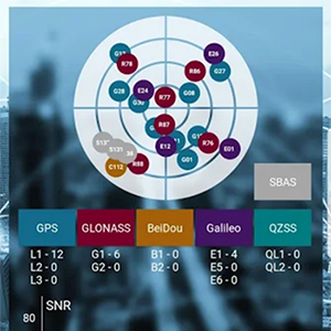
    Bentley Systems and Topcon joined forces in 2016 to jointly develop enhanced integration between their respective MAGNET and ProjectWise cloud services so that engineering and construction workflows could be integrated for improved project quality and performance.

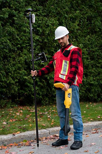
    Since then, Bentley and Topcon have continuously introduced innovations in surveying, reality modeling, scheduling and logistics, work packaging, machine control, and progressive assurance for construction.

    In 2017, they opened Constructioneering Academies, including at Topcon’s “sandbox” facilities, for construction professionals to experience new digital best practices, first-hand. During 2018, the companies assimilated Bentley’s SYNCHRO and Topcon’s ClearEdge3D acquisitions into constructioneering offerings.

    Digital Construction Works is chartered to embed its experts within constructors’ major project teams to advance and optimize constructioneering processes for delivering better design-build outcomes.

    Through its digital integration services, to connect and automate constructors’ existing processes with constructioneering, Digital Construction Works can make the best projects better while also helping to institutionalize these digital workflows throughout a constructor’s full project portfolio, the companies said.

    At the same time, experiences gained by Digital Construction Works will help guide Bentley Systems and Topcon in prioritizing their constructioneering software development investments.

    Digital Construction Works is led by CEO Ted Lamboo, previously senior vice president of strategic partnerships for Bentley Systems, and COO Jason Hallett, formerly vice president of digital construction and business development for Topcon.

    Greg Bentley, CEO of Bentley Systems, said, “When we and Topcon recognized the opportunity for constructioneering to finally industrialize capital project delivery, we committed respectively to completing its software requirements. Indeed, our new software capabilities make possible construction digital twins—converging digital context, digital components, and digital chronology. What remains, in going digital for infrastructure construction, is for constructors’ people and processes to take advantage of the technology. We and Topcon have now in turn committed many of our best resources, professionals experienced in both construction and software, to serve shoulder-to-shoulder, in virtual hardhats, to innovatively advance the required digital integration. The Digital Construction Works joint venture has the full management and capital commitments of both our companies, multiplying its unique strengths for helping to realize constructioneering’s potential to close the world’s infrastructure gap.”

    Ray O’Connor, president and CEO of Topcon Positioning Systems, said, “What Topcon and Bentley Systems initiated in recent years was done in the spirit of changing mindsets and processes on how we approach construction, and that collaboration has led to the development of this joint venture. The creation of Digital Construction Works perfectly aligns with our focus of helping the industry succeed in meeting infrastructure demands through technological innovations. Through the new organization, companies will have the opportunity to integrate hardware and software capabilities to more quickly and efficiently adopt new technology for more rapid productivity improvements. With customized services to address the individual needs of an organization, widespread adoption and technology improvements can be more readily realized. We are excited to take this journey with Bentley Systems in moving the industry forward.”

  • MicaSense offers Altum 3-in-1 sensor for ag drone mapping

    MicaSense offers Altum 3-in-1 sensor for ag drone mapping

    The Altum is a 3-in-1 sensor that combines thermal, high-resolution and multispectral imaging capabilities in one sensor. (Photo: MicaSense)
    The Altum is a 3-in-1 sensor that combines thermal, high-resolution and multispectral imaging capabilities. (Photo: MicaSense)

    The Altum sensor, offered by MicaSense, is designed for professional-grade agricultural drone mapping by enterprise and academic researchers. The Altum captures synchronized multispectral and thermal imagery, enabling aligned outputs for advanced analytics.

    Altum’s multispectral imagers are the highest resolution integrated multispectral solution available for drones, allowing for detailed RGB outputs and advanced crop classifications.

    Whereas before they had to fly multiple flights with multiple sensors, researchers, growers and service providers can now capture data for plant health, water stress mapping, phenotyping and more in one flight, with one sensor.

    The Microsense RedEdge-MX sensor aboard DJI's M210 RTK drone. (Photo: MicaSense)
    The Microsense RedEdge-MX sensor aboard DJI’s M210 RTK drone. (Photo: MicaSense)

    “The Altum design resulted from experience developing advanced analytics and understanding needs for advanced research,” said Justin McAllister, CTO and co-founder of MicaSense. “We realized the market is limited by time and cost constraints of owning multiple sensors and flying multiple passes over the same field. The goal of Altum is to simplify the workflow, and with synchronized capture, to provide results that can be correlated and quantified more easily.”

    Altum includes MicaSense’s standard five-band configuration of multispectral bands (red, green, blue, near-infrared and red-edge) and an integrated Lepton radiometric thermal longwave infrared sensor from FLIR Systems, providing temperature measurement for every pixel of the scene for additional crop data and optimization.

    https://youtu.be/Kdim4uol7S4

    Expandable high-capacity USB 3.0 storage allows users to fly longer and cover more area without landing to swap storage. In addition, advancements in image capture rate enables faster flight speeds.

    Users can process Altum data with industry standard software like Agisoft and Pix4Dmapper to generate an aligned, radiometrically calibrated six band (R, G, B, RE, NIR, T) geotiff, or access the raw data from Altum to process data themselves.

    Included with Altum is DLS 2, the patent-pending next generation of the MicaSense Downwelling Light Sensor (DLS). DLS 2 allows for a more streamlined integration as it combines both the DLS and GPS into one product. In addition, through proprietary MicaSense technology, the DLS 2 will offer significantly better calibration for changing light conditions and better measurements over time.

    Integrated solutions

    Altum’s multiple interface options and open API gives users the ability to utilize Altum on a variety of platforms. In addition to the DJI SkyPort integration, Altum is integrated with drone offerings from the following companies (with more to come):

    • North America: Drone Nerds (U.S.), BirdsEyeView Aerobotics (U.S)., OmniView Tech (Canada), Sky Flight Robotics (U.S.), Blue Skies Drone Rental (U.S.)
    • Europe: 3D Target (IT), Globe Flight (DE), C-Astral (SI), Droneparts.de (DE), Ecobotix (DK), NaviGate (PL), Quantum Systems (DE)
    • Asia: Cybernetech (Japan), Shenzhen Qianhai Yaqi Technology (China)

    DJI Payload SDK Program: Altum and RedEdge-MX for DJI M200 Series

    Through DJI SkyPort, MicaSense is able to provide seamless integration of its specialized sensors with DJI’s powerful line of enterprise drones, resulting in the MicaSense Altum and RedEdge-MX solutions. This provides users a high-quality drone and sensor combination they can rely on to capture quality data every time – with virtually no set-up time.

    The DJI SkyPort integration for Altum and RedEdge-MX features plug-and-play integration for Altum and RedEdge-MX right out of the box, including power and quick connect/disconnect, and enhanced light calibration with MicaSense DLS 2.

    “Solutions like the MicaSense Altum and RedEdge-MX demonstrate the value of integrating specialized industrial payloads to DJI’s powerful drone platforms,” said Jan Gasparic, head of Enterprise Partnerships at DJI. “By collaborating with solution providers, we are expanding the benefits of drone technology to more and more industries. In the case of agriculture, a specialized suite of sensors and more advanced level of analytics can truly bring tangible value to business workflows and decision making today.”

    The Altum and SkyPort enabled RedEdge-MX and Altum are available today through the MicaSense website.

  • GSA releases 2019 GNSS Market Report

    GSA releases 2019 GNSS Market Report

    Image: GSA
    Image: GSA

    The new GSA GNSS Market Report is now available for download. The report provides a comprehensive overview of the GNSS market and the global industry, as well as a focus on EGNSS differentiators and synergies with Copernicus, according to the publisher, the European GNSS Agency (GSA).

    Areas covered include:

    • A general overview of the GNSS market and a global industry overview.
      Analysis of macro-trends affecting GNSS, including climate change and the circular economy, big data, artificial intelligence, the silver economy, cyber security and the sharing economy.
    • A review of the main GNSS market segments in detail, including trends and developments, forecasts for future shipments, revenues and the GNSS installed base, and a look into GNSS user requirements.

    GNSS in Space. This year, the report features the “Editor’s Special: GNSS for NewSpace,” a section that introduces GNSS receivers in satellites and their relation to the evolving space sector.

    GNSS market monitoring is a key activity of the GSA. Market monitoring supports GNSS stakeholders in their planning and decision-making, and offers a clear tool to understand GNSS trends and evolutions.

    Since its launch in 2010, the GSA GNSS Market Report has become the go-to-source for information on the dynamic, global GNSS market segments and applications.

  • Richard Wiegmann joins VertiGIS as president and CEO

    Richard Wiegmann joins VertiGIS as president and CEO

    Richard Wiegmann as President and CEO. (Photo: VertiGIS)Photo:
    Richard Wiegmann as President and CEO. (Photo: VertiGIS)

    The board of directors for VertiGIS, a geographic information systems (GIS) software and solutions provider, appointed Richard Wiegmann as president and CEO.

    Wiegmann began his new role Aug. 1.

    VertiGIS comprises Esri Platinum Partners AED-SICAD, Geocom Informatik and Latitude Geographics (Geocortex), and aED-SYNERGIS, Dynamic Design and SynerGIS GIS & FM.

    Wiegmann, 49, lives with his family near Frankfurt. He brings extensive executive experience in software and services to the operational management of VertiGIS and was one of the company’s original board members. Previously, he was CEO and chief commercial officer of Sabre Hospitality Solutions, which in 2016 acquired Trust – International Hotel Reservation Services.

    “I’m excited to join the team at VertiGIS, and see so much potential for us in the GIS market and beyond,” Wiegmann said. “By bringing together major GIS companies, we can leverage the expertise of our employees and the strong cooperation of partners like Esri to provide our customers the best-in-market solutions for their businesses, and ensure they offer long-term stability and planning security.”

    VertiGIS’ product portfolio is used by more than 12,000 users in private-sector companies and government agencies. Current product brands include UT for ArcGIS, the 3A product line, Geocortex, GEONIS, ConnectMaster, GeoOffice, WebOffice and ProOffice.

    “I look forward to further developing our existing products and services with a great team, and bringing new ideas together in this highly interesting growth market,” Wiegmann added.

  • Trimble to acquire GIS company Cityworks for EAM expansion

    Trimble to acquire GIS company Cityworks for EAM expansion

    Photo: Cityworks
    Photo: Cityworks

    Trimble has signed a definitive agreement to acquire privately held Azteca Systems LLC (Cityworks), a provider of enterprise asset management (EAM) software for utilities and local government.

    Cityworks’ solutions address the global challenges associated with maintaining and replacing aging utility, transportation and public assets and infrastructure.

    The transaction is expected to close in the fourth quarter of 2019, subject to customary closing conditions and expiration of the waiting period u

    nder the Hart-Scott-Rodino Antitrust Improvements Act. Financial terms were not disclosed.

    Cityworks, based in Sandy, Utah, was launched in 1996 and provides a powerful and flexible office, cloud and mobile EAM software solution that is used by more than 700 utilities and local governments. EAM is a key technology and system of record relied on by organizations to address a wide range of applications in infrastructure development, maintenance and permitting.

    Cityworks is a leader in the mid-sized utility and local government market segments in North America and its solutions address organizations of all sizes with deployments serving some of the largest cities in the U.S.

    The Cityworks acquisition will expand Trimble’s strategy by adding an EAM software platform to its existing utilities and local government capabilities, which include mobile, IoT and infrastructure lifecycle solutions. The combination will provide a comprehensive digital platform — with real-time asset intelligence, workflows and analytics — for transforming the way governments and utilities prioritize infrastructure maintenance and construction investments.

    In addition, the acquisition will enable Cityworks to leverage Trimble’s global footprint in multiple industries.

    Together, Trimble and Cityworks will provide an expanded solutions portfolio to their partner network of architecture, engineering and construction (AEC) firms and software system integrators.

    Customers will benefit from integrated solutions that will enable them to realize improved infrastructure performance, increased productivity and better return-on-investment associated with infrastructure construction and operation.

    “Cityworks is a pioneer in developing software to address the global challenges associated with managing aging, critical infrastructure,” said Steve Berglund, president and CEO of Trimble. “Trimble has a long history of transforming industries by combining technologies and providing full solutions that help customers measure, assess, design and construct infrastructure at scale. With Cityworks, we now expand our solutions portfolio enabling customers to manage and optimize the performance of their assets across the entire infrastructure lifecycle.”

    “Trimble is an ideal match for Cityworks and the work we aspire to do in helping utilities and communities improve public infrastructure management. Joining Trimble is strategic, providing exciting growth opportunities and new opportunities for innovation,” said Brian L. Haslam, founder, president and CEO of Cityworks. “Cityworks as a Trimble company will accelerate our GIS-centric public asset management approach and allow us to increase the impact and value our solutions deliver to customers.”

    The Cityworks business will be reported as part of Trimble’s Resources and Utilities Segment.


  • Delivering the world through maps

    Delivering the world through maps

    GIS ready to meet demands of IoT, smart cities

    The mapping industry has taken to UAVs — sort of. Put it this way: UAVs are only one tool in the GIS (geographic information system) toolbox.

    A third of our respondents (32%) say that UAVs will be used for less than 10% of field survey activity in the next three years. In contrast, a quarter of our respondents say that drones with variety of sensors (photogrammetric, lidar, hyperspectral, etc.) will perform up to half of mapping work.

    The response is similar to replies in 2018. While UAVs are an exciting new technology for mapping, most respondents to our survey recognize the continued value of hands-on, in-the-field data collection. In fact, only 11% of respondents expect that mapping work on the ground will gradually disappear over the next three years.

    Chart: GPS World
    Chart: GPS World

    Sensors Aboard. When on board a UAV, 43% say the best sensor to use in conjunction with GPS/GNSS for mapping and data collection is a high-resolution still-image camera, which is highly preferred over video cameras. Today’s high-resolution cameras can capture details down to a few centimeters on the ground, even from an aircraft hundreds of feet in the air (see our August issue for more on aerial mapping).

    Other top sensor choices for our readers include lidar (light detection and ranging) at 32% and multispectral imaging cameras at 14%. Lidar (light detection and ranging) uses a pulsed laser to measure distances and generate precise, three-dimensional information.

    Rather than UAVs, airplanes and helicopters are the most commonly used platforms for acquiring lidar data over broad areas. Topographic lidar uses a near-infrared laser to map the land, while bathymetric lidar uses water-penetrating green light to measure seafloor and riverbed elevations. Lidar is used to create more accurate maps, make digital elevation models, assist in emergency response operations, to name a few applications. GNSS and INS systems translate the collected sensor data into static points for GIS.

    Multispectral and hyperspectral cameras capture images in infrared (IR) and ultraviolet (UV) as well as traditional RGB (red, blue, green). The main difference between multispectral and hyperspectral is the number of bands and how narrow the bands are — from 3 to 10 bands for multispectral to hundreds for hyperspectral. Practically speaking, multispectral imagery can be used to map forested areas, while hyperspectral imagery can be used to map tree species within the forest.

    Both types of cameras are used in agriculture, ecology, oil and gas, oceanography and atmospheric studies. They can map invasive species, monitor crop health, and help in mineral exploration. For building inspections, a multispectral camera can see water penetration, plumbing leaks, overloaded electrical circuits and malfunctioning mechanical systems.

    Chart: GPS World
    Chart: GPS World

    Cloudy, Chance of Maps. Anywhere, anytime access to geospatial data is increasingly important, fueled in part by both the internet of things (IoT) and smart-city initiatives. Geospatial technology enables effective and integrated planning by providing real-time location data and analytics.

    Most mapping providers have developed cloud software and storage, which helps organizations access data to meet their specific requirements. Along with the cloud, advances in mobile computing are enabling organizations to take GIS to the field, interacting with the information needed to view, capture, update and synchronize changes between the field and office. The field workforce can use maps to add validity to data, record observations, and respond to events.

    GIS software is also assisting connected cars and autonomous vehicles, an area expected to grow significantly (see page 38). The mobile GIS software market is expected to reach a CAGR of 18% by 2024, according to Global Market Insights.

  • SXblue ToolBox Application now available on iOS

    SXblue ToolBox Application now available on iOS

    Image: SXblue
    Image: SXblue

    Following the launch of its Android application in 2018, Geneq is now launching an iOS version of its SXblue ToolBox for iOS-compatible SXblue devices.

    The application was developed with special interest paid to raw data recording and NTRIP service connection.

    With the SXblue ToolBox iOS application, the user can analyze the position data provided by the SXblue receiver, as well as location metadata.

    More important for SXblue clients, the application can record, save and transfer raw data from the GNSS receiver, thereby allowing post-processing activities. The application also acts as a NTRIP client, capable of connecting to a NTRIP server for real-time kinematic (RTK) corrections, and thus allows the receiver to issue very accurate location information.

    Receiver configuration is easy through the application, with the ability to set up and save user-defined commands for subsequent use. The settings include constellation to be used, differential source, NTRIP login credentials list and more.

    In addition, the iOS application includes a series of audible and visual alarms that are user-configurable to determine the thresholds of information provided by the SXblue GNSS receiver.

    The main features of the iOS SXblue ToolBox application are:

    • Display of location information and quality of positioning data
    • Skyplot of all-in-view constellations: GPS, GLONASS, Galileo BeiDou, QZSS, SBAS
    • Recording of raw data and data transfer
    • NTRIP/DIP client to receive RTK corrections
    • Terminal to send commands and view the output data of the SXblue device
    • Audible and visual alarms
    • Activation of options and licenses via the application.
  • Trimble handheld AR SiteVision takes data visualization outdoors

    Trimble handheld AR SiteVision takes data visualization outdoors

    Photo: Trimble
    Photo: Trimble

    Trimble has introduced its Trimble SiteVision system, an outdoor augmented reality (AR) solution that enables users to visualize 2D and 3D data on virtually any project site with cellular or internet connectivity for easier and more efficient planning, collaboration and reporting.

    Combining hardware and software in an integrated, lightweight handheld or pole-mounted solution, users can view 3D models and assets in a real-world environment at a 1:1 scale, from any angle or position.

    The system consists of:

    • Hardware: The Trimble SiteVision integrated positioning system integrates the Trimble Catalyst DA1 antenna, electronic distance measurement (EDM) rangefinder and power management into a lightweight, handheld device that connects to a user-supplied Android mobile phone.
    • Software Subscription: Available to single users on a monthly or yearly basis. The SiteVision software subscription combines Trimble’s high-accuracy positioning services and cloud-based processing technology to create a centimeter-accurate AR system. The system leverages Trimble cloud-based processing to manage and deliver data and design models.


    SiteVision enables users to visualize digital models from a wide range of data collection, design and constructible modeling tools in open industry-standard formats including IFC and LandXML.

    For civil projects, SiteVision accurately visualizes data from Trimble’s Quantm, Business Center and Novapoint; design data from Civil 3D and Bentley OpenRoads; and GIS data from Esri ArcGIS software.

    Photo: Trimble
    Photo: Trimble

    SiteVision powers building information modeling (BIM) projects with open data from Trimble’s Constructible BIM solutions including SketchUp and Tekla, and BIM data from Autodesk Revit and AutoCAD software. For utility companies, PLS-CADD power line design, Distribution Design Studio (DDS) and other industry-specific design data is also supported.

    Using Trimble Connect cloud-based hosting, SiteVision can access models from all stages of the lifecycle of infrastructure and buildings—from initial concepts of roads or buildings through the operations and maintenance phase of the assets—to increase collaboration, enhance work accuracy and ultimately improve operations and utilization.

    SiteVision simplifies complex concepts by allowing users to blend digital content with real-world environments. For example, city planners can visualize a new building design in the exact spot it is to be erected, a work crew could identify the exact position of underground cables or pipes before digging, an electric utility can confirm placement of poles and lines with customers and crews, or a construction supervisor could assess the progress of heavy equipment by visualizing actual work performed against the site plan.

    “It’s easier to understand complex ideas when we can see them in a real-world context,” said Mark Nichols, general manager at Trimble. “SiteVision improves our understanding of projects and worksites with a handheld device that is accessible to a wide range of users. Augmented reality is now ready for everyday use in a wide range of applications.”

    Trimble SiteVision is available to order now through Trimble’s authorized distribution channels for Civil Engineering and Construction, Geospatial and Buildings.