Indoor location technology is evolving; indoor mapping is coming along and apps that seamlessly work in and out of doors will make a compelling experience more compelling. Bringing mobile location to indoors will stimulate our industry. The killer app? Apps that can self learn to be personalized to a user’s life, lived in and out of doors (check traffic before I leave my desk). Hop on board.
Indoor Mapping. The indoor market is getting more interesting as Google’s Street View Mapping edges indoors. In a new pilot project, Google is providing glimpses through the front doors of retail businesses. Restaurants, hotels, stores, and other venues will show a 360-degree inside perspective. The imagery will appear on Google’s Places pages, all using the same Street View technology that enables its other map images. The company’s plans are to eventually allow users to virtually enter indoor spaces from street maps. It is a way for businesses to entice new customers. Companies in the pilot volunteer for inclusion. The project links nicely to indoor mapping plans under way.
Finding Location Indoors. Cambridge Silicon Radio (CSR) introduced a new mobile phone processor to improve the accuracy of indoor navigation. It is a “self learning” indoor location platform that fuses real-time Wi-Fi, satellite positioning data, MEMS sensors, and crowd-sourced location data. The company claims it can achieve continuous and rapid indoor position fixes. The system’s distinction, says CSR’s Dave Huntingford, is it doesn’t require manual surveys to build and maintain its Wi-Fi and cellular location data base. The CSR system debuts next year.
Leading Vehicle Integration. “The automakers that can provide the most elegant integration of vehicle and mobile apps will lead the next revolution of providing social media and other capabilities in cars,” states a report from market analysts IHS iSuppli. Integration is critical as automotive infotainment will derive functionality from smart mobile devices like smartphones and tablets. Globally, Toyota and Ford lead in successful integration of car infotainment systems with mobile devices, IHS iSuppli reports. A study of production-ready applications showed that the Toyota Entune and Ford Sync AppLink apps had the highest performance on at least four criteria, including content variety, level of integration, daily relevance, and implementation.
Being Watched? The well-publicized case in front of the Supreme Court may define the power of police forces to put location devices on vehicles for surveillance. The court’s decision may extend beyond vehicles into the far more prevalent police practice of tracking cell phones. According to the Wall Street Journal, Los Angeles police tracked 295 phones, up 35 percent from the previous year. The paper reports that a magistrate in Texas who approves cell-tracking requests has used public records to estimate that U.S. federal courts issue 20,000 to 30,000 cell-phone tracking orders annually. In 2010, in comparison, state, local and federal courts approved a little over 3,000 wiretaps.
Location Data too Accurate? Precise location info spawns lawsuit. Customers concerned about HTC’s location tracking practices have hit the company with a lawsuit. HTC is charged with using the AccuWeather app to track customer’s precise locations and providing it to advertisers who use it for location targeted ads. It boils down to location precision. The suit claims that HTC collects “unnecessarily precise” location data. Weather is a regional phenomenon based on coarse location and can be easily determined by cell towers, and not the GPS data HTC obtains. The AccuWeather app is integrated into some HTC phones and cannot be uninstalled, according to the suit. HTC can be added to the honor roll of company blunders that fuel concerns about the misuse of location data.
New Innovators. Localmind was one of the winners at recent competitions for young location-oriented companies. This real-time, location-based clever Q&A platform leverages social check-in services. Users can ask questions of others. For instance, someone might query about waits at a restaurant, liveliness at a bar, or the state of the Wi-Fi at a coffee shop. Another winner, Tagwhat, offers a multimedia location guide that reveals videos, photos, narratives, and audio about the world around people wherever they go, based on the users’ pre-selected, customized interests such as food, music, movies, heritage, and sports. Containment in a personalized bubble may or may not be a good thing. A third winner, Right Back on Track (RBT), enables schools to reduce truancy and drop outs. The system lets schools and families know the whereabouts of truant students to enable interventions to attract the students back in school.
By Nicolas Couronneau, Peter J. Duffett-Smith, and Alexander Mitelman
Cell-phone users are often more concerned about the speed of positioning than the accuracy, making time-to-first-fix the most important factor in a GNSS mass-market receiver’s perceived performance. However, TTFF is generally difficult to characterize and optimize because of the need to encompass a wide range of environments, including indoors.
One method of characterizing the time-to-first-fix (TTFF) is to measure it directly, using a signal generator and a real receiver. This method avoids the approximations of analytical solutions, but it is usually time consuming and it does not provide much insight into the factors affecting the TTFF since it is gen erally not possible to change the receiver’s architecture. Another approach is to use Monte Carlo simulations and a model of the acquisition process. This approach is more flexible than direct measurement, but again it can take a long time to simulate weak-signal environments.
We have developed a third approach based on analytical methods but regulated by measurements of the signal-to-noise ratio in target environments. Using this approach, one can quickly calculate the probability distribution of the TTFF for different signal strengths and acquisition parameters.
To illustrate this method, we consider a model of an assisted-GPS receiver combined with experimental measurements of the GPS L1 C/A signal taken indoors. The results are presented in Figure 1, where the probability of the TTFF (horizontal axis) is plotted as a function of the time after the beginning of the data series at which the acquisition process started (vertical axis), calculated using a 400-second GPS data series measured indoors. The strength of our approach is that we can quickly calculate the TTFF probability for any given confidence level and it is quite general so that it can be extended to other types of receivers.
Flow-graph representation of the acquisition process for one channel. FA is the false-alarm state and D the correct detection of the signal from this satellite. H1 and H0 represent respectively states in which the signal is and is not present. PFA|H1 is the probability of false alarm in a window where the signal is present and PFA|H0 the probability of false alarm in a window where the signal is not present. P D is the probability of detection, and PMD the probability of missed detection.Figure 1. The probability of the TTFF (horizontal axis) as a function of the time after the beginning of the data series at which the acquisition process started (vertical axis), calculated using a 400-second GPS data series measured indoors. Note that the colored scale is not linear.
Modeling the Acquisition Process
A GPS receiver must first acquire signals from a sufficient number of satellites before it is able to calculate a position. This search is often the major contributor to the TTFF.
GPS Acquisition Architecture. The acquisition can be represented as the search for a specific, yet unknown, combination of three parameters in a larger search space. These are:
the Gold-code number used to generate the pseudo-random noise (PRN) sequence,
the code phase, and
the carrier frequency offset.
The last of these has contributions from the frequency offset caused by the relative motion of the satellite and receiver (the Doppler effect) and the frequency bias of the receiver’s local oscillator.
In general, signal detection is performed by correlating incoming signals with a local satellite signal replica for every combination of parameters in the search space. The correlated signal is then integrated and a “hit” is declared if the integrated value crosses a predetermined threshold. The time required to test for the presence of a satellite signal for each combination of parameters is called the dwell time. We suppose here that this is approximately equal to the integration time.
GPS receivers usually include some degree of parallelism. We consider a receiver having N channels, each channel dedicated to searching for signals with a different PRN sequence. Within a channel, the frequency and code-phase search spaces are further divided into several windows. We assume that all the parameter combinations within a window are searched in parallel, that is, within a single dwell time. This model of the acquisition process is outlined graphically in Figure 2.
Figure 2. An illustration of the acquisition process. The large colored rectangles represent the search windows and the inner smaller rectangles represent the different combinations of search parameters.
Parallelism can be implemented in hardware using massively parallel correlators or in software using fast Fourier transform-based techniques. The details of any particular implementation are not relevant here; only the number of channels, the number of windows, and the sizes of the global search spaces are needed.
Acquisition Time Probability Distribution. The flow-graph method provides a graphical representation of the acquisition process. An example is shown in the Opening Figure. Each node represents a state of the acquisition process at the end of a dwell time. The lines joining the nodes represent the transitions of one state to another with the given probabilities. Typical states during acquisition are false alarm, missed detection, correct detection, and correct non-detection.
The flow-graph method has already been applied to the GNSS acquisition problem, in particular for calculating the mean acquisition time of a signal in a GNSS receiver. Here we extend that work by considering the acquisition of all the satellites required for a position fix and, by deriving full probability distributions, we establish a model of an assisted-GNSS receiver.
The opening figure shows the various probabilities of transition that can be calculated from detector statistics.
Flow-graphs rely on the properties of the probability generating function (PGF) of a random variable. A PGF makes it straightforward to calculate the probability distribution of the total duration of a sequence of events of random durations since the PGF of the sum of random variables is simply the product of their PGFs. It is also straightforward to calculate the mean and standard deviation of a random variable directly from its probability-generating function.
Aside from these properties, PGFs are less convenient and less intuitive than probability distribution functions. A generating function does not provide a direct calculation of the probability of an event, unlike a distribution function. For instance, calculating the acquisition time at an arbitrary confidence level (for example, 90 percentile) requires a contour integral over the PGF. Furthermore, some operations are easier to perform on density functions, for example, calculating the probability of simultaneous events.
It can be shown that the probability mass function of a discrete random variable can be approximated from its generating function using a discrete Fourier transform. This property forms the basis of our method: using the fast Fourier transform (FFT), we can quickly calculate the entire acquisition probability distribution associated with the generating function of a flow-graph.
Assisted-GPS Model
We now focus on the specific architecture of an assisted-GPS receiver, such as is commonly found in cellular phones. In this type of receiver, the TTFF can be shortened by performing the acquisition in two steps.
The acquisition starts by searching for any satellite signal in a full search space in which every parameter takes its full range of values. The Doppler frequency of the first satellite acquired can be calculated using assistance data and then removed from the observed frequency offset to give the contribution to the frequency offset caused by the receiver’s clock frequency offset. This is common to all search channels and can be removed from the remaining search spaces.
The second stage of the acquisition is thus performed for the remaining satellites over a reduced search space.
Stage 1 Full Search Space. The first threshold crossing for a single satellite is characterized by the time-to-first-hit (TTFH). Using an FFT, we can calculate the distribution function P(Thitfull ⩽ t) of the time-to-first-hit Thit(k) of the kth channel.
Mathematically, the time to first hit across all N channels, Thitfull, is the minimum of {Thit(k)}, whose distribution function is calculated by:
We assume that we have no means of detecting a false alarm at this stage and so the frequency parameter of the first threshold crossing is used to calculate the receiver’s clock frequency offset. This crossing may, of course, be a false alarm, and we take this into account later.
Stage 2 Reduced Search Space. At the reduced-space stage, the goal is to calculate the probability of having acquired M satellites out of N channels. The value of M depends on the number of pseudorange observables needed to solve the position equation. High-sensitivity assisted receivers that do not have signal tracking loops can only measure fractional pseudoranges together with an uncertain number of integer code periods. Using a coarse position estimate of the receiver, this uncertainty can be resolved, and a 3D position fix obtained, by using M = 5 satellites.
Calculating the detection probabilities at this stage involves some combinatorial arguments. In the following, (Ωm) represents the set of all combinations of m elements from the set Ω. For example, if Ω = {a, b, c}, then (Ω2 ) = {{a,b}, {b,c}, {a,c}}.
The probability of having “hit” at least M signals out of N channels at time t is given by
In this equation, Ω = {1, …, N} represents the set of the receiver’s channels and Thit(k) is the time to first hit of satellite k. Because each satellite is received with a different signal strength, these random variables have different distributions for every satellite.
The probability of having correctly detected at least M satellites before time t, P(TDreduced ⩽ t), is calculated by enumerating all the possible combinations of hit and detection events. The probability of having at least one false alarm before a given time t, P(TFAreduced⩽ t), is simply calculated by taking the difference between the probability of a hit and the probability of detection.
The number of possible combinations grows quickly with the number of channels. For an 8-channel receiver, there are 35 combinations, and for a 24-channel receiver there are 8,855 combinations. If the number of summations is becoming too computationally demanding, one solution is to form sets of signals with similar strength, and perform the combinations over these smaller sets with an appropriate weighting. Within a smaller set, all the signals have the same signal strength and acquisition times have the same probability distributions — a situation that is similar to calculating the order statistics of a random variable, which is not problematic in the case of identical distributions.
TTFF Probability Distribution
The last step before obtaining an expression for the TTFF distribution is to combine the two stages of the assisted acquisition. The total acquisition time is the sum of the time to first hit in the full-space stage and the time to the correct detection of M satellites in the reduced-space stage. This sum is easily calculated using generating functions, with the corresponding flow-graph represented in Figure 3.
Figure 3. Overall flow-graph of an assisted receiver. Uhit(z), UD(z), UFA(z), and UP(z) are the generating functions of the time to first hit in the full-space stage, the time to detections in the reduced-space stage, the time to a false alarm in the reduced-space stage, and the penalty time to recover from a false alarm, respectively.
Using the inverse of the FFT method presented above, we calculate the generating functions of the time to first hit in the full-space stage, Uhit(z); the time to M detections in the reduced-space stage, UD(z); the time to a false alarm in the reduced-space stage,UFA(z), and the deterministic time penalty to recover from a false alarm,UP(z).
Modeling false-alarms demands special attention. There is little information in the literature about the detection of false alarms in assisted-GPS receivers. One solution could be to detect a large residual error at the output of the positioning algorithm. Here, we take an easy path and simply introduce a penalty time, TPenalty, to represent the (deterministic) time needed to recover from a false alarm. The penalty time should be chosen to represent the behavior of a specific receiver.
For GNSS receivers capable of tracking the signals, the full pseudorange can be recovered after detection of a synchronization word in the navigation message. The duration of the tracking stage is a random variable, since the tracking can start at any position in the navigation message. Although we have not investigated this situation in more detail, we suspect that the tracking stage can be simply modeled by a uniform probability distribution. The length of this distribution depends on the navigation message structure and the amount of navigation data needed by the receiver to obtain a full set of decoded data. A new block can be added to the flow-graph in Figure 3 using the generating function of the uniform distribution, and the TTFF for a standard GNSS receiver can then be calculated.
Experimental Results
We analyzed the TTFF with the signal strengths measured in an office environment.
A picture of the office is shown in Figure 4. One side of this office has a window, but the sky view is obstructed by a large building a few tens of meters away. There is no direct line of sight to a satellite, although the window may allow some strong reflected signals to get in to the office.
Measurement of Weak Signals. Direct measurement of the strengths of indoor signals can be challenging since the signals are often too weak to be tracked reliably. We used a Nordnav R30 dual-input receiver with one input connected to an outdoor antenna mounted on the roof of the building and having an unobstructed view of the sky. The other input was connected to an antenna in the office. We used the tracking information from the stronger outside signal to track the indoor signal.
The signal carrier-to-noise density ratio (C/N0) was recorded for 400 seconds, starting every day at the same sidereal time, for six consecutive days.
Figure 5 shows the signal strength for one particular satellite (GPS PRN9). We see that the signal strength follows a similar pattern every day. This is representative of a multipath fading environment: the signal coming from the satellite is scattered in the office, and the resulting signals interfere constructively or destructively, depending on the phase difference between the different paths. The overall signal strength is therefore related to the relative position of the satellite which, for GPS, is about the same every day at a given sidereal time.
The variations of the signal strengths of all the observable satellites show fading patterns which are uncorrelated, as we expect the satellites to be spread across the sky (see Figure 6). It is difficult, if not impossible, to predict the distribution of signal strengths at any specific instant, and so the TTFF varies depending on the instant at which the acquisition process begins.
Figure 5. Indoors signal strength (C/N0) for satellite PRN09. Each colored curve represents the signal strength measured on a different day, starting at the same orbital time.Figure 6. Measured C/N0 for all observed satellites during the first day of recording.
TTFF Indoors. We now apply the signal strength measurements (Figures 5 and 6) to the TTFF calculation method presented above. This allows us to determine the probability of the TTFF as a function of the starting time of the acquisition since the beginning of the data recording.
We chose the detection parameters as follows: the coherent integration time was 1 millisecond, the non-coherent integration time was 300 milliseconds, the threshold was set for a probability of false alarm of 10–6, the time offset of a code phase was between 0 and 1 milliseconds, the penalty time for a false alarm was set to 600 milliseconds, and five satellites were required to solve the position equation. The ephemeris, a coarse position within 150 kilometers of the true position, and a coarse time within 30 seconds of the GPS system time were provided by the assistance data.
The results (see Figure 1) provide some insight into the acquisition process.
We can discern two patterns in the TTFF distribution. During the first 150 seconds of the analysis, that is, if a real receiver had started acquisition during that time, the TTFF showed large variations. This was caused by the multipath. The fading of the signals from the various satellites, although uncorrelated, led to severe degradation of the TTFF when the acquisition was started during a combination of strong fades. In our analysis, we have made the simplifying assumption that the strength of any particular satellite signal remains constant over the acquisition period.
After the first 150 seconds, the TTFF became more nearly constant. On examining the C/N0 time series, it was clear that the reason was the appearance of a signal from the satellite with PRN 27 (black curve in Figure 6) which was consistently stronger than the remaining signals after 120 seconds. This satellite had the highest elevation (more than 60 degrees) and the reception was probably by transmission through the ceiling of the office. In this situation, the phase difference between the reception paths was small, hence there was little fading. This single satellite significantly improved the TTFF, in particular by shortening the time of the first stage of the assisted-acquisition process.
It can be shown that the distribution of the acquisition time of a satellite, at a given starting time, can be approximated by an exponential distribution. This distribution explains the non-linearity of the relationship between the TTFF and the probability of fix, as observed in Figure 1. The non-linear effect becomes important when calculating the TTFF at a given performance level. In our example, the 50-percent probability of fix was about 1.2 seconds. Moving the requirement to 90 percent made it about 2 seconds, and 95 pecent about 2.5 seconds.
Conclusions
In presenting a method of calculating the distribution of the TTFF representative of a mass-market receiver indoors, we have seen how existing techniques can be extended and combined to provide an analytical model for assisted receivers. Power measurements of real signal show how the TTFF can vary depending on the combination of signal strength at the time the acquisition process is started. This suggests that an improved strategy for acquisition in large search spaces might be to start two or more independent acquisition processes, separated by, say, 1 second, in order to benefit from the advantage of one of the signals appearing strongly after a fade.
The lead author gratefully acknowledges support for this research from Cambridge Silicon Radio, CSR plc.
Nicolas Couronneau is a Ph.D. student at the Cavendish Laboratory, University of Cambridge, UK. He graduated as an electrical engineer from Supélec, France. His research interests are in the area of probabilistic methods applied to the acquisition of GNSS signals.
Peter J. DufFett-Smith is reader in experimental radio physics at the Cavendish Laboratory. His Ph.D. was in radio astronomy. He is the founder of Cambridge Positioning Systems Ltd. and, with others, invented the Matrix positioning method and Enhanced-GPS technologies. He holds more than 20 patents, and is a consultant to the GPS Group at Cambridge Silicon Radio.
Alexander Mitelman received his Ph.D. degree from Stanford University in electrical engineering. His research interests include signal-quality monitoring, algorithm and system design, and the development of testing methodologies for GNSS and hybrid systems.
The location industry is evolving. In the near future we won’t be discussing navigation and mapping as a way of finding the nearest Starbucks. Contextual location driven advertising will start delivering solid revenues, as soon as the market becomes better organized. The value of location information will be magnified as it shifts to the cloud. Vehicle manufacturers will be creating their own rich contextual location information. Near field communication, NFC, with its seat between consumers and cash registers, will provide some of the most valuable location data. These are points all made at last week’s LocNav conference by The Where Business.
Tipping Point. Half of Americans are not using smartphones. Location becomes more interesting when everyone has a smartphone and it reaches a tipping point. Social proximity and location has big benefits. “When everyone has a smartphone, you can connect via wireless mesh,” says Michael Metcalf of Yahoo. “If I’m in a line at JFK for a cab, I can let others know my destination and I can reduce the line and wait by half.” Geo-fencing has been stymied by the battery drain caused by frequent GPS pinging. Wireless mesh technology solves this issue. Another winner in location is near field communications, which works in short range proximity to enable purchases and other activities via smartphones. It creates a valuable database that includes precise location tracking data.
Power to the Automotive OEMs. Unlike the rest of the industry, automotive OEMS won’t need to rely on location integrators or cellular providers to provide them with a driver’s location. With integrated GPS and communications, they are well equipped to understand the context of where drivers are located, what they may be doing, and where they may go next. “In the past, the automotive industry didn’t get a share of the advertising revenue generated in the vehicle by radio, which was usually even installed as OEM equipment. “That will change,” says Lou Brugman of Pioneer Automotive. “In-vehicle infotainment will be adding location-based social networking, which might include automatically sharing your location or estimated time of arrival with specific contacts. The excuse for being stuck in traffic might not work as easily when you’ve actually been lingering over lunch.
Contextual Advertising Road Block. Everyone is talking about contextual location-based advertising, but it is being held back by a complicated eco-system. “There is little conformity. There are open standards and closed standards,” says Chris Peralta of Nokia. “Contextual advertising offerings are operating as separate silos.” Peralta feels that MirrorLink, previously called Terminal Mode, is getting traction. The MirrorLink Consortium is dedicated to cross-industry collaboration in developing global standards and solutions for smartphone and in-vehicle connectivity.
Heard in the Hallways:
“Sensors that use location will change more people’s lives than giving turn-by-turn directions faster. In the future location conferences will have nothing to do with navigation and mapping.”
“Apple required us to add a navigation application for the iPad. We hadn’t even considered that the iPad would be used in a vehicle for navigation.”
“People will accept dirtier data that is cheaper. Mapping that is from a user-generated community will be good enough. There will be some mapping that will sell for a premium for some uses, but map data will be commoditized.”
“In the future, all mobile advertising will be opt-in. It won’t continue an upward trajectory if it doesn’t do otherwise.”
Intelligence in the Cloud. The shift of information to the cloud will have a significant impact to our industry. “The cloud moves localization to a global context,” says Kanwar Chadha of CSR. “In the cloud, it becomes intelligent context and simplifies information that can feed sensors that work on low energy.” It is important to provide the right level of location accuracy for different contexts. For privacy concerns, social networking users don’t want location that is too precise; yet for mobile promotions, the closer the better. Weather can be regional for most common uses although agriculture requires precision. Having the location intelligence in the cloud enables more sensor usage.
Smartphones and Shopping. It sounds redundant, but Google’s research indicates a heavy reliance on smartphones while shopping in brick and mortar stores. A whopping 70 percent of smartphoners use their phones as a shopping aid while inside of a store. Almost 25 percent report researching purchases on a phone, visiting a store to view merchandise, but then buying online. The benefits of mobile advertising are significant. “Hyperlocal advertising has an ROI of about 800 percent,” said Surojit Chatterjee, of Google, “Mobile ad campaigns are seeing 40 percent more calls compared to desktop.”
I will host a free GPS World webinar on Thursday, December 1, with interesting guests. Details will be provided in November’s Wireless Pulse.
Many press reports recently said that the Federal Communications Commission plans to require GPS in all mobiles by 2018, including LBS Insider (October 12, 2011). However, the FCC said that isn’t quite so, saying that “not before 2019, on a date still to be determined, carriers will have to meet the more stringent location accuracy standards that now apply to those carriers using a handset solution for [enhanced 911], and they may choose which solution to use.”
FCC spokeswoman Lauren Kravetz said that these technology solutions may be GPS chipsets, network-based, or a hybrid. The FCC said, after the conclusion of an eight-year period that ends in early 2019, it will sunset the existing network-based rule and require all wireless carriers to meet “the more stringent location accuracy standards in the handset-based rule. The FCC will then set a specific sunset date for a network-based standard — after further notice and comments.”
An announcement completely overshadowed by the Apple iPhone 4S rollout may have a major impact on the location-based services industry. The FCC has said that all wireless carriers, including voice-over-IP service and landline providers, are required to integrate GPS into phones by 2018. In other news, Intel bought Telmap, which has made inroads into the LBS market with its partnerships with carriers.
In a move designed to allow first responders to locate 911 emergency calls, the Federal Communications Commission will require all wireless operators, including voice-over-IP service and landline providers, to integrate GPS in phones by 2018.
The FCC says the majority of mobile phone users will have GPS-installed devices by the 2018 deadline. The FCC did not set a deadline for phones that do not use GPS-based technology. In addition, VoIP is going toward more mobile applications, rather than its original substitute for landline service.
Most industry experts agree that the rise of location-based services occurred when the FCC mandated that carriers have location capability during its enhanced 911 rulemaking. Wireless carriers chafed at the deadlines and accuracy requirements. However, the rulemaking did bring market awareness to the carriers to the benefits, and potential new markets, coming from this mandated location requirement.
While it is too early to tell how much this will help drive LBS markets, the FCC said the decision, which was overshadowed as it was announced the same week as the rollout of the Apple iPhone 4S, was spurred by the desire to modernize 911. This means locating emergency callers quickly, particularly from smartphones and other mobile devices.
But have the wireless carriers lost their grip on LBS? In 2009, the surge in the number of GPS-enabled smartphones, proliferation of handset and mobile OS application stores, and increased availability and consumer demand for free or low-priced LBS applications has had a huge impact on the traditionally carrier-controlled LBS market, said Dan Gilmartin, Where vice president of marketing.
“The decreased costs and barriers to entry into the market place and ability to reach consumers through low- or no-cost viral social marketing channels is enabling small application developers to compete with the established LBS developers. The result is a highly competitive landscape that beforehand was dominated by only a few major players,” he said.
Gilmartin said that Google’s decision to offer free turn-by-turn navigation and acquisition of ADMob for $750 million reinforced the expectation that the viable business models for LBS in 2010 and beyond will include offering free or “freemium” services to consumers through ad-supported and other non-traditional funding models. “That said, the carriers’ subscription model still appears viable, at least for the short term, and consumers are proving to be willing to pay for what they perceive to be high-quality applications both on- and off-deck, navigation being the most prominent category,” he said.
Go Ask Apple?
The rollout of the Apple iPhone 4S may not be the biggest thing for the LBS market, but it does open it further to another tier-one carrier in Sprint. Like other iPhone models, the 4S has GPS embedded, but offers Siri voice-recognition that integrates with its navigation capability.
When LBS Insider contacted Sprint for comments on the new iPhone 4S and the FCC decision that GPS be installed in all smartphones, we got the public relations brush off to “Go ask Apple.” Ask Apple about GPS and LBS? This is an interesting response, as Sprint was one of the first major LBS market players, particularly their Nextel folks who were very innovative with location technology in the early days.
Intel Buys Telmap
At least one company in the LBS market is doing something right when a big company like Intel buys it. As GPS World reported, Intel bought Telmap, the Israel-based LBS company. The deal was announced at the recent Intel AppUp Elements developer conference in Seattle.
Motti Kushnir, Telmap chief marketing officer, said that since Telmap is a private company, financial details cannot be disclosed. He said the deal will take effect by the end of the year. “Telmap will be a wholly owned subsidiary and will maintain its independence as well as its brand,” Kushnir said in a prepared statement.
Kushnir said no layoffs are expected, nor will facilities close or be moved by Intel. “On the contrary, we are expected to grow in order to support the growth of our business both in existing and new territories,” he said.
One of the reasons Intel bought the company is that it is sees mobility as one of its growth engines — and location is a key component, Kushnir said.
Telmap says it has 6 million users for its IP portfolio that includes mapping, local search, and navigation. This includes a new restaurant LBS initiative in Israel. The company is working with Rest, a large Israel restaurant guide to provide location-based coupons to customers.
In other LBS industry news:
Fierce Wireless made an admittedly subjective list of the worst cell phones of all time. Garmin’s ill-fated Nuvifone G60 made the list. The phone, a partnership between Garmin and Asustek Computer, featured LBS — and had a $5.95 monthly charge for premium service. Fierce Wireless says that it was a failure in part because of Google’s free location services.
Nokia will be closing down its operations in Bonn, Germany, and Malvern, Pennsylvania, with an expected loss of more than 1,300 jobs in the Location and Commerce divisions. According to published reports, operations will consolidate in the Berlin, Boston, and Chicago offices. Another 2,200 layoffs will come from its European manufacturing operations.
This column has admittedly neglected traffic markets lately, but will be running more stories and interviews soon. With that, some big news has come out of that market, namely Google’s recent deal with INRIX to power its navigation and mapping applications. INRIX traffic information will be integrated in Google’s online products and services and on mobile phones.
Meanwhile, INRIX competitor TomTom is launching a Traffic Foundation that brings together stakeholders from academia, industry, and policy-making to help reduce traffic congestions. The company also rolled out its Custom Probe Counts at the ITS World Congress, that allows government and business markets to assess traffic density. The company also expanded its coverage from 14 to 18 countries.
The 2011 Frankfurt Motor Show is underway. The Ford Evos concept car is having its debut and overtakes the company’s Sync offering, with a high level of social networking and connectivity features. A departure from the Sync approach of vehicles as smartphones on wheels, this plug-in hybrid is designed to always be connected to the cloud. Some of the distractibility found in the Sync has been diminished. The driver’s “personal cloud” makes automatic adjustments to music, temperature, traffic checks, and navigation that reflect learned personal choices of the driver and her schedule. Hooking a car up to the cloud comes with significant risks. Moving from stand-alone isolated in-vehicle systems to the connected network world carries the threat of being hacked and exposed to viruses. iSec researchers demonstrated unlocking and starting a car by sending text messages to its alarm system. The problem, however, is much broader than having a car stolen.
White Flag. The industry has surrendered mobile check-in to Foursquare. It isn’t often one gets to report on a Facebook failure, but after one year of disappointing traction, the company has abandoned Places. A location-based social network offering, Facebook Places allowed users to share location at venues, and see who among their contacts were checked in nearby. When Places launched a year ago, it wasn’t clear if start-ups like Foursquare, Gowalla, and Whrrl could compete with Facebook. Yet the day following the Facebook Places launch, Foursquare sign-ups swelled with a record number of new users. Dennis Crowley of Foursquare asserts that they have captured 10 million users by “being about what people are currently doing,” while Facebook records what people have done in the past. Facebook users won’t be able to check in, but can add location to a tag.
No More Gowalla Badges. Unable to compete with Foursquare on check-ins alone, Gowalla is shedding some of its check-in bells and whistles and adding social travel guides for travelers. These location-based communities emphasize image sharing and storytelling and are now available in 60 cities worldwide. Gowalla is also featuring content from National Geographic and other travel-oriented sites.
Looking for Metrics. Local, location-based search is a key driver for mobile advertising. Google has 200 million active mobile map users in more than 100 countries. Navigation is search’s bosom buddy. “In general, I think you can look at navigation as a type of conversion, for example, after searching for directions,” says Suroijit Chatterjee of Goggle, as reported by The Where Business. “Better attribution models are needed, however, in order for revenue generation to develop further.”
Fourth Amendment and Location: Law and Order Edition. In November, the Supreme Court will hear the most important fourth amendment case in years, and it is all about location. The question is whether the police need a warrant to attach a GPS device to a suspect’s vehicle and track movements. The court case arose from an investigation of a Washington man who was suspected of being part of a cocaine selling operation. The police had obtained a search warrant, but installed the tracking device one day late.
Literary Location Judges. Recent rulings from judges across the country that have included tracking of cell phone locations have sided with protection of privacy. It is common for judges to invoke George Orwell’s 1984 and its depiction of a futuristic police state that keeps citizens under constant surveillance. In November, the Supreme Court Judges will address the specific question of whether the placement of a tracking device on a vehicle qualifies as a search, and if the surveillance by location technology is different from conventional methods such as tailing suspects and stake-outs, which do not require a warrant.
Navv Revamps. Navv has recreated itself in the navigation industry by adding social networking into its personal navigation offering. Users can share their locations, itineraries, or current routes to their Facebook wall, directly from the app. Check-ins via Foursquare are automated. In March, the Navv navigation app was removed from the Apple App Store in a now-resolved argument with Apple over rights to the navigation app’s name.
Mark your Calendar. Don’t miss LocNav 2011, October 18-19 in San Jose. The Where Business has co-located its annual Location Business Summit and Navigation conferences to create an even bigger show. I’ll be moderating the panel, “Connecting People Places and Things: Advertising and Social Networking in the Location Ecosystem.” My guests include executives form Expedia, Nokia, Yahoo, and A&G. See you there.
The October issue of Wireless Pulse will be published one week later than usual to allow reporting on the LocNav show.
Google is at it again. This time Motorola Mobility is on the buying block. What does this mean to the location-based services market? Another potential location platform market closed off? Some industry experts believe this is the case. In addition, Iridium and TeleNav are making LBS news with recent product launches and acquisitions.
The recent $12.5-billion Google acquisition of Motorola Mobility has some industry experts saying that the location market piece of pie is getting smaller every time the search giant makes a deal.
“I think with Google controlling both the hardware and software stack of the Android ecosystem it will be hard for any technology company to work with Motorola. They want to own the whole shooting match for themselves,” said Ted Morgan, Skyhook Wireless CEO.
Boston-based Skyhook is suing Google for allegedly using tactics to block Motorola Mobility and Samsung from contracts that use the company Wi-Fi-based tracking system in Android smartphones.
Many industry experts have said that the main makers of Google Android smartphones should feel challenged as well as the company has seemingly gone into business against them.
Google has made many moves into the location business in the last two years. It is trying to grab a large share of the European traffic market by offering real-time services in 13 European companies. Google shook up the navigation market with free navigation service for Android phones in 2009. Last month, LBS Insider detailed Google’s purchase of The Dealmap, which offers a location-based daily deal service.
Google’s acquisition of Motorola is another step in a development strategy that appears to be aimed at increasing the company’s ability to compete across multiple markets that are served by mobile computing, said Mike Dobson, Telemapics president, author of Exploring Local. “[This is] supplemented by the company’s ability to supply its customers proprietary content that can provide a unique and informed world view whether those customers are at home or on the road exploring new geographies,” he said.
Dobson says that Google clearly wants to compete on a level playing field with Apple and appears to feel that the only way they can do so is to acquire one of the premier manufacturers of mobile phones. “While Google had hoped to control the mobile market by developing Android, doing so has not allowed them the gather the strategic control of phone design, pricing, positioning, placement, or distribution,” he said. “Conversely, Apple has been able to bring mobile phones to the marketplace whose features, functionality, and looks have generated a design revolution that has enchanted consumers in a manner dissimilar to anything we have ever seen in the mobile marketplace.”
Although Motorola’s brand has been tarnished in recent years, it is clearly the case that they are an extraordinarily talented developer of popular mobile devices that continue to stretch to boundaries of the capabilities of the cell phone world, said Dobson, who believes that this is evidenced by the fervor of anticipation surround the current release of the dual-core, 4G LTE compatible Motorola Droid Bionic.
Motorola’s design team, however, does not appear to understand the consumer mobile phone market with the same ability to interleave design and hardware functionality that is the hallmark of all Apple products, including the iPhone. “Nor do I believe that Google has the capabilities, as of this time, at least, to remedy this situation,” he said.
Dobson said that Google’s proposed acquisition of Motorola, coupled with those like its acquisition of Zagat’s and proposed acquisition of ITA Software, an airline ticketing company, seems to indicate that Google is interested not only in providing the platform and OS, but also the common content that might be of interest to users of their mobile devices. “When Google’s control of key content is wrapped within the control of the delivery platform and nested within the Internet’s most successful advertising delivery platform, AdSense/AdWord, it would appear that Google will have advantages in the mobile world far superior to any company that currently exists,” he said.
Now that the U.S. government has blocked AT&T’s acquisition of T-Mobile, all eyes are on Google’s newest purchase. Dobson has said that while it is impossible to estimate the size and data usage total that can be attributed to location services, there is little reason to assume that it does not mirror the growing trend in data growth.
At the time the AT&T/T-Mobile deal was announced, Dobson told LBS Insider that if AT&T can advantage itself by easing its spectrum crunch through the acquisition, it could result in the company being more interested in navigation and LBS than in the past.
Iridium Making LBS Foray
As GPS World reported, McLean, Va.-based Iridium Communications announced that its Iridium Force strategy will include LBS and M2M to grow its personal mobile satellite capabilities beyond satellite phones. The new capability enables communication with Wi-Fi-enabled devices such as smartphones, tablets, and laptops. The Iridium Extreme, which is the company’s smallest, will be connected to online portals with GPS and LBS capabilities.
The company also says that Iridum Tracking Portals allow customers to access location monitoring that show real-time status and location, scheduling regular check-ins, geo-fencing, and other features.
In a July interview with LBS Insider, Patrick Shay, Iridium vice president and general manager for data services, said that the machine-to-machine market constitutes the company’s fastest growing segment. The company said it reached 500,000 total billable subscribers for its satellite voice and data services worldwide. The breakdown of subscribers includes 90 percent commercial customers and 10 percent U.S. government customers.
TeleNav Buys LBS Firm Goby
In a smaller acquisition, of which financial details were not disclosed, TeleNav purchased Boston-based Goby, a local and travel search startup that focuses on mobile applications — and will look at advertising revenue models.
TeleNav has been tight-lipped about the acquisition, only saying that they are impressed with the small company and its personnel and technology. Published reports indicate that the company, and 10 employees, are staying in Boston.
For the past several months, controversy has raged over the revelation that Apple and Google tracked mobile subscriber location movements and stored that information in an unencrypted file on the handset, where it was potentially vulnerable to hacking and other inappropriate usage. The resulting Location-gate scandal highlights the sometimes tenuous control of mobile subscriber information versus the business objectives of dominant platform and applications providers. These business objectives may include immediate revenue opportunities from the subscriber being tracked or broader self-interest initiatives, such as collecting marketing data that may be valuable to third parties like advertisers, or building subscriber-reported Wi-Fi access point databases.
Furthermore, while much has been written about the privacy impacts of the collection and use of consumer location information, few articles have clearly outlined the technologies behind Apple and Google’s tracking activities. It is important to fully explore and understand these technology methods, and how they differ from other location technologies in use, in order to properly evaluate the threat posed by Location-gate and to develop responses that maintain privacy while enabling the benefits of location-based services.
Location, Tracking, and Storage
iPhone and iPad subscribers had previously been aware that Apple tracked their location via GPS, because the company notified subscribers when an app required the use of GPS to identify location, and asked them to opt-in. However, soon after Location-gate erupted, Apple’s vice president of software technology, Bud Tribble, testified to Congress in May 2011 that Apple also had been tracking device locations over time using triangulation between nearby Wi-Fi access points and wireless base stations. Triangulation is the moderately accurate method in which the mobile device measures the nearby cell site or access point identifications and possibly signal strengths, typically pinpointing device location to within a few hundred meters.
Following this revelation, Apple’s initial response was that “users are confused” and that it was simply “maintaining a database of Wi-Fi access points and cell towers around your current location…to help your iPhone rapidly and accurately calculate its location when requested.” Soon after Apple location tracking activity was revealed, it became known that Google was doing essentially the same thing, although to a slightly lesser degree (Android phones stored only the 50 most recent coordinate fixes and up to 200 Wi-Fi access-spot locations), and using a similar triangulation method without the subscriber’s explicit knowledge. Google Android devices also have GPS capability.
Why, if both OS providers embedded or leveraged GPS in their phones, would they resort to a less accurate location method, triangulation?
Neither company has provided an answer. We know that the triangulation method uses less battery power than GPS, conserving battery life for other uses while filling in performance holes for GPS in urban and indoor environments. Also, unlike with GPS, mobile subscribers are either not able to disable triangulation or must disable it separately. More relevant is the fact that triangulation allowed the OS providers to identify location automatically and track it over time in the background without the subscriber’s knowledge, for purposes such as building and maintaining a subscriber-reported database of Wi-Fi access points.
From a privacy perspective, there is a dramatic difference between tracking someone’s location over time (the bread crumb trail that Apple and Google used), versus locating one’s position for a specific purpose and handling the location information only within the confines of a secure wireless network. Useful applications that are universally accepted, such as E911 for safety-of-life situations, employ the latter method.
Other players in the mobile ecosystem, such as wireless network operators, have collected subscriber location information as well, but not by storing it in the device as historical files in the same way that Apple and Google did. Some information exists on the network side in association with billing records for calls (call detail records or CDRs), but this is not bread-crumb tracking of cell-IDs. E911 calls have records stored for use by public safety agencies, but most users never make an E911 call. Other messages containing coarse location may exist on a transitory basis (for example, location area updates), but these are not typically aggregated or stored for later processing.
Depictions of location information stored on handset and in operator network.
Alternative Geo-Location Methods
There exist location methods that provide far greater privacy and security than the location tracking and handset storage that Apple and Google have utilized. Standard methods exist for performing location using the wireless service provider’s network elements. These are called control-plane methods, which follow standards developed by 3rd Generation Partnership Project (3GPP) and 3GPP2. Other standard methods exist using IP transport from the client phone to a location server. These are called user-plane methods, such as the Secure User Plane Location (SUPL) standard from the Open Mobile Alliance (OMA). Both control- and user-plane location standards incorporate mechanisms for data security and user privacy. These standard control- and user-plane methods differ from the proprietary methods used by many client applications and OSs, which are inherently user-plane in nature but with non-standard implementations.
Methods using a client application with handset-based location on the mobile device, also called user-plane methods, bypass the carrier’s wireless network elements and instead rely on an IP connection to transmit information from the client application to a server on the Internet. These user-plane location methods, such as client applications for handset-based A-GPS, as discussed, are already widely in use for location-based services. Handset applications are inherently vulnerable to hacking and privacy intrusions, as the recent spate of mobile viruses on Android has highlighted.
A-GPS is highly accurate at identifying location in direct line-of-sight conditions with the satellites (open sky conditions), as found in suburban and rural areas, but performs less well in challenging dense urban and indoor environments. GPS in the phone can be easily disabled by the end user, and the receiver chip in the handset can cause significant battery consumption when used in demanding applications, such as navigation and monitoring geo-fences. A-GPS, as used by wireless network operators for navigation and other location-based services, does not usually store unencrypted files of historical location information in the handset, as Apple and Google did.
Alternative, network-based, or control-plane, methods make use of the wireless services provider’s network elements to keep location information wholly behind the security of the operator’s firewall, employing highly standard protocols for security and privacy. Control plane location methods are used for today’s safety-of-life applications, like E911, where security and privacy are prime considerations.
One example of a network-based location technology that can work in control-plane is RF pattern-matching (RFPM), which is the only high accuracy, software-based, scalable location solution that requires no additional hardware changes/additions to the mobile device or at the base stations. It compares mobile measurements (signal strengths, signal-to-interference ratios, time delays, and so on) against a geo-referenced database of the mobile operator’s radio environment. RFPM boasts a 100 percent security record for subscriber mobile location information it produces, for critical applications such as E911 emergency call and law enforcement location applications.
Location information for growing consumer uses deserves the same privacy and security protections that other standards-compliant control-plane solutions provide for today’s mission-critical and safety-of-life location applications. RFPM works extremely well in non line-of-sight conditions such as dense urban and indoor environments, where GPS-based solutions face challenges. RFPM also offers low battery consumption and geo-fencing capabilities, which makes it ideal for providing location for the growing opportunity in location-based advertising and other location-based services (widely believed to be the true driver behind Apple and Google’s location tracking activities).
As Location-gate clearly illustrates, there is no shortage of methods to identify and track one’s location via mobile device. Now that the issue has been raised, it is imperative that the entire mobile ecosystem — network operators, OS providers, regulators, and subscribers — clearly understand what methods are used, when one’s location is being identified and tracked, and what is being done with that data. Breadcrumb trails are useful if you’re trying to find your way out of the forest, but not if Big Brother is tracking you.
Marty Feuerstein is chief technology officer of Polaris Wireless, where he leads research into new products, algorithms, system performance, and regulatory activities. He has a Ph.D. in electrical engineering from Virginia Tech.
“GPS can no longer evolve fast enough. Satellite-based systems cannot maintain the speed of development now required for the hyper-fast evolutionary pace of modern applications and devices. For positioning for the future, it has become exceedingly clear that GPS now needs a terrestrial component.” — from a Locata Corporation prospectus
A large number of companies and engineers have thrown billions of dollars at trying to improve GPS in urban and indoor applications,” states Locata Corporation co-founder Nunzio Gambale. “From a technological perspective, Locata has created something completely new: the capability to autonomously create a GPS-style system on the ground.”
Members of the GNSS community can see for themselves at Locata’s coming-out party at ION-GNSS 2011, including release of a Locata signal interface control document (ICD). GPS World took an advance look at the technology in a June trial of the demo that all ION attendees can see. This article presents these reports, after an outline of the technology.
The key to Locata’s positioning system is the signal generated by the Locata transceiver, or LocataLite, to synchronize its time to other LocataLites in a network. Locata creates a network that, according to the company, “is in almost perfect synchronization” without using atomic clocks. Each transmitter dynamically synchronizes with other Locata transmitters using a patented method called Time-Loc. Gambale says that a Locata network currently locks to about 2 nanoseconds.
Each LocataLite base station has an uninterrupted range of approximately 10 kilometers, with indoor signal penetration similar to that of a mobile phone tower.
The company emphasizes that its transceivers are not pseudolites, but devices that create TimeLoc synchronization, and thereby enable an autonomous synchronized network that, locally, looks like GPS. The local constellation is under local control, and can therefore be designed for deployment at any power, any frequency, or any density required by an application.
The networks can scale easily. The term “local” can mean a room or warehouse (100s of m2), a campus or open-cut mine (10s of km2), an airport terminal area with approach and landing routes (100s of km2), or a wide area, range, or city (1,000s of km2)
Gambale sees markets for Locata’s technology in defense, mining, emergency services, construction, and security. Locata is designed to integrate with existing GPS technology, as simply another constellation. This means an approprieate GPS-Locata receiver can use the satellite signal when outside the range of a Locata network. To a combined GPS-Locata chip, the LocataLite will appear as another satellite.
The company sold its first Locata network in July 2005. Locata has signed partnership agreements of various kinds with Leica Geosystems and Newmont Corporation (mining), the U.S. Air Force, the Advanced Navigation Technology Center of the Air Force Institute of Technology, and several other firms under non-disclosure terms. There was an initial test deployment at Holloman Air Force Base in May 2008, as a truth reference system spanning a test area of about 52 by 15 kilometers.
For high-multipath environments such as indoors and warehousing, the company’s latest development is a new antenna called a TimeTenna, which it will demonstrate at ION-GNSS.
Future research and development will focus on the miniaturization of the Locata receiver. Work has begun on a combined GPS-GLONASS-Locata chip that can be integrated initially into professional and industrial devices, and eventually into consumer devices such as mobile phones.
Locata plans to work with integrators only, not with end users, making the technology available to qualified partners developing receivers and applications. The ICD is the first step in Locata’s technology rollout.
LocataLites awaiting boards. Each LocataLite transmits four PRN signals.
A Long Time Coming
Eric Gakstatter, Survey editor
You may have heard the Locata name pop up over the past several years. It would be in the news, then back underground into stealth mode. About five years ago, I heard some interesting rumors about its technology but I decided not to take them seriously until I saw some real products.
Two years ago, I sat down with Nunzio Gambale, Locata CEO, at the ION-GNSS conference. At last year’s ION, I talked with him again. At that point, I understood the potential impact of Locata’s technology — if it worked as advertised. I again told myself that before I spent more time on it, I wanted to see a product introduced to the market based on Locata technology. In January of this year, it happened.
Leica Geosystems introduced its terrestrial GPS Augmentation Network for the mining industry, based on Locata technology. To me, that was a pivotal point. Leica is a reputable company and wouldn’t introduce a product without a thorough vetting.
I contacted Nunzio and we had further discussions. I wanted to see the technology in action — hard to do since Locata is based in Australia, I’m in Portland, Oregon, and an early installation occurred in South Africa. Fortunately, the company’s need to do a real run-through of its demo on site, prior to ION, meant that I got what I wanted to see, right on my doorstep: a Locata preview at the Oregon Convention Center in June.
The Technology
Essentially, Locata has developed a system that is very much GPS-like in that one has a network of reference stations (LocataLites) that interface to an unlimited number of rovers. One major difference is that there is no space segment. It doesn’t need or use satellites. Essentially, each reference station behaves like a satellite on the ground, with the rover moving around inside the polygon formed by the reference stations. The rover position is accurate to the centimeter level.
The value of the Locata receivers is that they don’t need a clear view of the sky to operate like a GPS receiver does. Yes, that means centimeter-level positioning indoors, where RTK GPS doesn’t work due to satellite visibility constraints, as well as outdoors.
Sound cool? It is. I saw it working indoors at the Oregon Convention Center. Locata staff set up a large room with Locata reference stations around the perimeter. They had two different rovers: one mounted on a small push cart and the other on a golf cart. We were able to move the rovers around the room freely and view the updated coordinates at 1 Hz intervals (although it’s capable of much faster update rates).
The Challenges
The new TimeTenna (see facing page) is large. Today that form factor is required to handle the high-multipath indoor environment. Locata is working on a scaled-down version, although it’s not unreasonable to envision the current model being mounted on a forklift or other vehicle if it was mechanically hardened. The antenna for Locata’s outdoor systems (for mining and other less hostile environments) is much lower profile and similar to a standard GPS antenna.
The Locata system requires that you manage a network of Locata reference stations. Similar to an RTK network, the Locata system is based on a network of reference stations around the project area. The baseline distances can be quite long (tens of miles), but nevertheless, one must install and manage the network much as one would a GPS RTK network, albeit with much less IT department involvement than a GPS RTK network.
Lastly, Nunzio Gambale wholeheartedly agrees that Locata’s technology is still developing. He likens it
to where GPS was in 1990. I tend to agree. The antenna technology needs to reduce in size and the system architecture needs to be vetted for reliability in production environments. But keep in mind that Leica and the U.S. Air Force’s 746 Test Squadron have already bought into Locata’s technology in a big way.
Although I don’t pretend to have the technical understanding that some of the others in the room possessed during the June demo, I did hear one of the sharper engineers exclaim “genius” at one point, referring to the design.
It’s certainly worth a close look as Locata’s technology continues to develop and be deployed. I think the day isn’t far away when we will see a system from Locata that will allow a user to transition seamlessly from centimeter-level positioning outdoors using RTK GPS to centimeter-level positioning indoors without breaking a step.
Now I’m a Believer
Tony Murfin, Professional OEM editor
I was invited to Portland in late June to preview an operational system which promises to help GPS in tough signal situations and work well indoors. While Europe, China, India, Japan, and of course Russia are all working to get more operational satellites in space, Locata in Australia has quietly been perfecting its terrestrial navigation system. I say perfecting because skeptics and naysayers have criticized Locata and what was seen as a pseudolite system with a rather lengthy development cycle. But nothing speaks as loudly as an operational system adopted and fielded by Leica Geosystems or a contract with the U.S. Air Force to get people’s attention back in the right place, even though Locata would claim it is only just getting started.
As I walked into the Portland Convention Center I was certainly apprehensive as to how any GPS-like system could function well within the massive concrete and steel building. When I found the smiling Locata group tucked away in one of the side ballrooms, it didn’t take long before I became a believer. Those wall dividers that allow the Convention Center to reconfigure rooms are apparently referred to as Acousti-Seal 931 Steel Operable Wall panels — yep, perfect multipath reflectors. So to see totally repeatable few centimeter positions in this cavern was not what I was anticipating.
The ballroom’s carpeted floor had been carefully laser-surveyed with a matrix of 5-meter squares, with a high-precision dot marking each grid intersection. LocataLite stations were set up at each corner and one in the middle at the far end, each with three antennas. A master station at the left corner of the entry wall originated the TimeLoc signal, and on each station one antenna pointed to an adjacent station, over which TimeLoc synchronization was cascaded around the network. This is a key feature of the ground network, allowing it to become fully synchronized and also to be extended or reconfigured at will.
Of course, when you run your own ground network it helps to be able to run at power levels significantly higher than GPS, so it’s easy for each station to communicate with another, provided they roughly have line-of-sight of each other — kind of like having to actually see a GPS satellite to get it into your GPS position solution. If you have some buildings or bushes or trees to contend with, having higher power available makes things easier, especially if you want an RTK carrier solution.
The secret to working indoors appears to be the TimeTenna phased-array antenna that Locata demonstrated in the steel-clad ballroom. With this top-hat-like antenna mounted on a wheeled cart along with a receiver and laptop, and positioned over one of those surveyed locations on the carpet, we could easily see that positions within less than 5 centimeters were consistent and solid. As a truth system, the company also had a motorized laser scanner pumping out centimeter-level positions on a parallel measurement system, and it was clear that there was excellent centimeter-level correlation.
But don’t take my word for it. Come to Portland for the ION-GNSS conference, September 20–23, and see the Locata demo for yourself — you’ll be impressed too!
Then there is the sole-source U.S. Air Force contract that has Locata updating an existing network to provide independent reference positions over 2,500 square miles of the White Sands Missile Range in New Mexico. The Air Force apparently needs to know how its navigation systems work when it turns on localized GPS jamming. The Locata system is designed to give the Air Force better than the specified <18-centimeter position accuracy in GPS-denied environments.
In August, Locata cleared the final USAF critical design review milestone for the wide-area White Sands Missile Range deployment. This is clearly a good sign that Air Force wants to continue with the next-generation Locata system. With GPS denied on this range, test vehicles will likely be constrained to inertial-only navigation, but with a LocataLite receiver onboard pumping out high-accuracy position measurements, the Air Force will no doubt have plenty of location data to track dynamic performance under GPS jamming conditions.
Another application that Locata has been investigating involves airborne trials in Australia, where initial results indicate position accuracy of less than 3 meters at up to 50 kilometers. The trials have involved a ground network with six base stations spread over a roughly square area of 1,500 square kilometers.
A University of New South Wales test aircraft equipped with precision GPS, inertial reference system, and laser scanner for truth reference use flew to within 3 to 49 kilometers of the reference stations at around 7,000 feet, producing the reported <3-meter code solution. Trials data is still being analyzed to produce a higher accuracy carrier solution, and Locata expects to issue these results at ION.
Airborne Reference Equipment
Leica has apparently been working with Locata for some time. The proof-of-concept installation at a 300-foot deep diamond mine in South Africa and a production set-up at a gold mine in Western Australia are going strong.
The gold-mine installation has now been extended to two pit sites using 15 LocataLite transmitters in total. LocataLite receivers are mounted on vehicles, atop drills and shovels, and all run off the multi-pit Locata network. The mobile units not only carry LocataLite receivers, but also precision Leica GNSS receivers running off side-by-side antennas. As time progresses, the ultimate solution will use integrated multi-constellation/LocataLite receivers: the Locata signals integrated into a combined satellite+terrestrial receiver position solution, using a single integrated antenna.
It’s easy to envisage such an integrated receiver and antenna where the Locata ground-network signals are used as just another local constellation. The investment to get to such a receiver would of course have to be justified by a whole proliferation of Locata networks. This would seem to be on the way, given the significant progress that Locata has now unveiled.
Will It Fly — Literally?
William Shears, aviation engineer
If you are an aviation satellite navigation enthusiast, you probably noticed this hasn’t been an auspicious year for aviation GNSS or for GNSS applied to any other user segment that needs highly reliable GNSS service. Between personal privacy jammers, instances of accidental interference, and the big chill sent through the community by the LightSquared debacle, many are asking if GNSS is now or ever will be reliable enough to be a sole means of position and time for safety-of-life applications.
A few years ago, the very idea that ordinary people would want to own GPS jamming devices and that they would be easily obtainable on the Internet would have been considered absurd. Similarly, the idea that the U.S. government would not vigorously protect GPS from interference was just not credible. But here we are in mid-2011 and the vulnerability of GNSS to interference has come home to roost, in several very big ways. This new awareness of the weaknesses of GNSS has led the U.S. Federal Aviation Administration (FAA) and civil aviation authorities of other countries to start rethinking their long-term strategies with respect to satellite navigation.
Even well before LightSquared crept into the consciousness of the GPS community and then burst forth as the apocalyptic specter that threatens to virtually end the utility of GPS in North America, the FAA had begun a study to consider the need for an alternate positioning, navigation, and timing (APNT) system to support critical aviation needs. The idea being that as the U.S. air traffic management system transitions to become increasingly dependent on management of traffic via four-dimensional trajectories, reversion to a non-trajectory based mode (for example, controllers vectoring aircraft as they do today) would become unfeasible. Hence, airplanes will need a very reliable source of 4D positioning and outages for any extended period of time due to interference, or anything else will be unacceptable. The FAA set about studying what level of performance would be required for a system intended to back up GNSS in the future. Other countries began to follow suit, and whereas the concept of an APNT was obscure a year and a half ago, it has become a significant point of discussion at the International Civil Aviation Administration (ICAO) as well as within various countries, including the United States, Australia, and several in Europe.
At first blush, the Locata system would seem to be a ready-made solution poised to fulfill aviation’s need for a GNSS backup system. In fact, acting as an independent backup (and/or an augmentation to) GNSS is one of the main motivations in Locata’s development. The technology seems to have promise in meeting the aviation community’s needs for an APNT. Locata is relatively mature technology that has demonstrated accuracies well in excess of what is required of an APNT meant to back up GNSS for enroute, terminal, and non-precision approach operations. Perhaps even precision approach and landing could be supported. Also, the system is very flexible, which suggests that service coverage could be tailored as needed around important airports. The system has significant redundancies built in, including multiple frequencies, multiple antennas for path diversity, and the ability for the network to reconfigure which LocataLite uses which other LocataLite for time synchronization.
Given this flexibility and redundancy, it should be possible to configure a system that provides highly reliable service where it is needed. Another major advantage of the Locata technology for aviation is the higher signal power level that comes from using terrestrial signals rather than signals from space. In theory, a Locata system would be more robust to interference than space-based GNSS signals.
Some people are indeed thinking about Locata for aviation use. Locata has conducted flight trials in Australia using a prototype demonstration network of six LocataLites covering an area of more than 1,500 square kilometers around Cooma airport in Australia. Locata has reported code positioning solutions of better than 3 meters at ranges up to 50 kilometers, and will present higher accuracy carrier-phase solutions at ION. The U.S. Air Force is also preparing to use Locata in an aviation environment as an independent truth reference.
At the ICAO Navigation Systems Panel (NSP) meeting in May 2011, the Australian panel member presented a paper outlining the general need for an APNT. The paper included a description of Locata as an example of what an APNT solution might look like. However, it is interesting that the paper fell short of proposing that the panel pursue Locata as the solution or to suggest that any standardization of a solution for APNT begin immediately. In spite of all the potential advantages discussed above, the Locata system faces a major obstacle before it can practically be used in aviation applications: standardization.
The first aspect of standardization that is likely to be a huge impediment for Locata (or any other APNT proposal, for that matter) is spectrum. The Locata systems implemented to date have been designed to operate in the 2.4 GHz unlicensed industrial applications band. For Locata to support safety-of-life applications, national aviation authorities will require that an APNT system use spectrum that is properly allocated for use in a safety-critical aeronautical navigation system, that is, spectrum allocated for Aeronautical Route Navigation Services (ARNS). Spectrum allocated as ARNS is afforded special protection from interference. Coordination of services in or near ARNS spectrum is often difficult, time-consuming, and expensive. For example, coordination between civil aviation use of the 108–118 MHz band (used for instrument landing systems, or ILS, and VHF omnidirectional range, or VOR) and FM broadcasting in the 88.1–107.9 MHz band produces real costs and restrictions to be borne by the FM broadcasters. Consequently, any proposal to convert non-ARNS allocated spectrum to ARNS is likely to be met with significant opposition.
Spectrum is a finite resource, and virtually all spectrum is already in use by someone. So, the reality is that a future APNT will likely have to be implemented in some existing ARNS spectrum, since a new global allocation of spectrum for ARNS is an unlikely proposition.
The current allocations for ARNS include:
108–118 MHz (ILS/VOR),
960–1215 MHz (DME/Mode-S/ADS-B/SSR/JTIDS/MIDS),
1556–1626 MHz, and
5.1–5.25 GHz.
All indications are that a Locata system could be could be operated at these frequencies. However, services that already exist in those bands will continue for the foreseeable future. So, to be viable, a Locata system would have to coexist in one of these bands with other existing systems, that is, not interfere with the operation of those other systems. Such coexistence has yet to be demonstrated either by analysis or test.
After suitable spectrum has been identified, the next major hurdle for Locata is standardization of the signal-in-space to the degree that supports interoperability of equipment produced by different manufacturers in different countries. The Locata ICD released at ION-GNSS 2011 is a good step in the right direction. But for an aviation application, a great deal more would need to be specified, including details about the waveform (spectral mask, out-of-band emissions, and so on), the protocols for producing the signals, and the standard protocols for the application of data to derive a position solution. A clear allocation of responsibility between the ground processing and airborne processing will need to be defined so that system integrity can be analyzed and assured.
At the international level, such standardization activities can take a decade or more. The length of time required depends on the maturity of the system that is proposed for standardization. The existence of a similar standard, with perhaps a significant user base and operational experience also helps (for example, an IEEE standard or RTCM standards). So, again, the ICD is a good start.
Beyond the technical aspects of standardization, there are political and institutional aspects that can often be more formidable barriers. Issues with spectrum have already been mentioned. Beyond that, there are issues with intellectual property. Creating aviation standards based on proprietary technology is unpopular although not unprecedented. Proposals for standardization are more likely to be successful the fewer strings, such as licensing agreements or fees, that are attached. This is a challenge since companies that have worked hard to develop cool new technology are often reticent to give away their intellectual property in the name of standardization.
Given all the barriers, how does new technology ever get implemented in civil aviation? Typically, applications begin in one of two ways:
in support of war.
in support non-safety related industrial applications.
The military has historically pioneered many technologies (radar, DME/TACAN, GPS) that would probably not have been developed otherwise. Even after the initial military experience, there is typically a period of time when the new technology is used in a non-safety-critical capacity to support some commercial objective. In the case of Locata, some potential applications would be flight-test position-reference systems, high-precision photogrammetry, high-precision positioning for crop dusting, and any other applications that require a highly robust, high-accuracy position solution in a well-defined region where interoperability and certification are not issues. Those are relatively small niche applications, which may provide some valuable operational experience.
However, serious movement towards adopting Locata as a standard for APNT is unlikely to happen without the support of at least a couple of large countries. Even a large user base with equipage does not guarantee that countries will adopt the technology or that air navigation service providers will authorize the use of the technology for safety-critical applications. For example, many carriers are equipping with broadband Internet equipment to provide service to the passenger cabin. Yet, there is no serious discussion of using that datalink capability for safety-related communications. Similarly, a very large number of aircraft are equipped with Aircraft Condition and Reporting System (ACARS) datalink, yet use of that system is largely limited to non-essential Airline Operational Communication (AOC) applications.
So will Locata fly? I believe that is entirely up to Locata and other companies that work with Locata to address the initial military and niche airborne positing markets. Operational experience gained by such early adopters will be critical in laying the groundwork for the support that will be needed from large states like the United States, Australia, China, and those in Europe, if Locata is to be a player in the longer-term international standardization of APNT.
In the near term, Locata is already serving the aviation community by demonstrating the art of the possible relative to what a ground-based navigation system based on modern technology could be.
New technology and wireless carrier openness now make real-time access to telephone location information available to the enterprise with no application required on the mobile device.
Yes, that’s right: no application required! Cloud-based location, offered via direct connections to wireless operators, changes the playing field for enterprises to introduce instant operational efficiencies. Marrying location insight, privacy controls, and multi-modal communications through network application programming interfaces (APIs) provides enterprises with flexibility, cost savings, and time-to-market advantages. Whether delivering geo-targeted promotions, dispatching services, verifying worker activities, or performing other location-relevant actions, businesses now have cross-carrier access to location information for more than 85 percent of U.S. wireless subscribers — instantly!
This enables businesses to go app-less with no costly, time-consuming deployment and maintenance of handset applications. Additionally, no specialized hardware is required. Location through carrier networks also assures secure and tamper-proof delivery of the location information since no potentially hackable client software is involved in the generation or delivery of that information. It comes straight from the carrier network over secure connections.
Cloud-based deployment, such as that available through TechnoCom’s Location Platform, opens up location intelligence to all device types, including both smartphones and feature phones. This removes a huge barrier that exists with the existing smartphone-only applications and enables businesses to immediately tailor their workflows and business processes to utilize the knowledge of real-time location from a secure and dependable source. Development cycles and costs are a fraction of those required for smartphone applications, such as Droid or iPhone apps, and the adoption hurdle of user download initiation is eliminated.
Simplification of access and deployment paves the way for adoption and finally opens the floodgate for location-based services to be implemented on a large scale across all wireless networks. This is analogous to the inflection point that cross-carrier text messaging access and interoperability had on cellular text messaging adoption rates in the ’90s.
By leveraging technology similar to that in the carrier networks and proven for use in 911 emergencies, businesses instantaneously benefit when new data is exposed by wireless operators, such as device capabilities, presence, rate plan status, roaming status, and so on. Enterprises may immediately harness this insight with upgrades to their server applications and no new technology deployments required in the field. That offers businesses a huge return on investment as they integrate once and consume enhancements dynamically. Location from the cloud opens up a new, instant intelligence frontier that was not possible for businesses to leverage just last year.
This unprecedented access to location information comes with a responsibility to comply with industry-accepted privacy controls. To make this easy on enterprises that are not expert in such policies, TechnoCom Location Platform provides carrier-approved privacy management functionality, and we work hand-in-hand with our customers to ensure their implementations are in line with best practices established by CTIA.
Tapping into location from other mediums such as VoIP, Wi-Max, NFC, Wi-Fi will increase the ubiquity of cloud-based location access even further. As devices get smarter and more powerful, better communications, device intelligence, and positional awareness will catapult businesses to yet another level of efficiencies in interacting with their mobile users, workers, and assets.
Mario Proietti is co-founder and chief executive officer of TechnoCom Corporation, and a member of the Editorial Advisory Board of GPS World magazine. He has a master’s degree in electrical engineering from the University of Southern California. TechnoCom delivers cross-carrier location services to enterprises through its location platform’s web services APIs. The company also integrates location technologies into wireless networks, products, and software, and works with wireless carriers to enable E911 and location-based services.
Microsoft is contributing to the latest location privacy jitters. Missteps by Microsoft, Apple, and Google have the potential to dampen uptake of location solutions. Microsoft published the estimated locations of millions of laptops, cell phones, and other devices with Wi-Fi connections. The location database was assembled by Microsoft’s access to Windows phones and by vehicles that drive streets and record Wi-Fi signals accessible from public roads. The data were published on Microsoft’s Live.com website.
The problem is that Wi-Fi devices can be individually identified by a unique code, often called a MAC address. It’s not just Wi-Fi routers that can be identified. Phones and computers can be used as Wi-Fi access points, via tethering and other means, and their location can be monitored. Using the Microsoft data on Live.com, CNET tracked an HTC mobile device’s movements between house addresses in the city of Columbus, Ohio.
Skyhook conducts similar Wi-Fi mapping, but according to Ted Morgan of Skyhook, does not provides direct access to its database. “All our partners use our client location engine, which does the scanning and lookups to our system,” says Morgan. “We don’t gather any MAC addresses of client devices, only access points and devices that act as access points.” Google collects similar location information and curbed access to the data a few months ago after a CNET article appeared. Microsoft just announced it too would now restrict access. When will these guys learn?
Googleola Marriage. The announcement of Google’s intention to buy Motorola Mobility for $12.5 billion, a heavy bucket of cash, will have repercussions throughout the industry. Google will become a mobile manufacturer in head-to-head competition with Apple and Research in Motion. For Research in Motion, maker of BlackBerry, this may be a kiss of death, unless they are snapped up by someone like Microsoft, who may feel pressured to join the game. Google will have bought itself entry into the ferocious patent lawsuit war between Motorola Mobility and Microsoft at a time when relations between Microsoft and Google had improved.
Google’s Larry Page made assurances on the company’s blog that Android would remain an open system. “This acquisition will not change our commitment to run Android as an open platform. Many hardware partners have contributed to Android’s success and we look forward to continuing to work with all of them to deliver outstanding user experiences”. Say that as he may, other Android handset manufacturers will now be competing with the supplier of their operating software in a distribution channel tangle.
Connected Car. The connected car, a vehicle with embedded modules and wireless services that link to the cloud and the car’s operating system, continues to evolve. The carriers are aggressively staking out territories. Verizon has shown off a car equipped with a 4G LTE modem with OnStar prototype apps. Sprint Nextel has worked with Aeris Communications to bring the Sprint network and cellular connectivity to the Hyundai connected vehicle program. AT&T has partnered with Panasonic Automotive.
Ford has led the car manufacturers with its SYNC offering that provides hands-free, voice controlled in-car connectively. Already in 3 million vehicles, SYNC will become available on Ford’s entire passenger line-up for $295, down from its current $395.
More than half of surveyed U.S. consumers find the concept of a connected vehicle appealing, according to a survey by Alcatel-Lucent. When it comes to opening wallets, the top applications are augmented GPS; maintenance, tracking, and notification; Wi-Fi; advanced voice features; and online environmental analysis.
It’s not all about Smartphones. The global mobile app market for feature phones will almost double by 2016, reports Ovum. The success of smartphone apps will drive feature phone apps to a predicted $1 billion market. Feature phones outsell smart phones, but have lagged in applications uptake. The upswing should be helped by the increasing ease of developing apps and publishing them for this market.
Personalization, not just Location. Feature phone mobile advertisements that are tailored to a consumer’s “tastes and interests” are four times more effective than offers based on location, time, or lifestyle, according to a poll of 2,000 U.S. consumers, commissioned by mobile marketing company, Upstream. The marketing activity that was found to most likely lead to a follow-up action included mobile coupons; opt-in text alert or message; an e-mail received on a mobile phone; an ad on a mobile website; or an ad that appears during an Internet search of a product or service.
Mark your Calendar. Don’t miss LocNav 2011 October 18-19 in San Jose. The Where Business has co-located its annual Location Business Summit and Navigation conferences to create an even bigger show. I’ll be moderating the panel, “Connecting People Places and Things: Advertising and Social Networking in the Location Ecosystem.”
Once again, it looks as if Google is taking a giant leap into location-based services with its recent acquisition of The Dealmap. Is this deal a signal that LBS market viability may be tied to the social shopping market? The market is potentially huge, with two big players and a third, Google, quickly developing. But is this the market that will propel LBS to the next level? One analyst says yes…and no.
Technology giant Google is once more trying to corner more of the social shopping market by buying The Dealmap, a 15-month-old company that offers its own location-based daily deal service.
Menlo Park, Calif.-based The Dealmap collects data from hundreds of sources and arranges deals by location, on its website and a smartphone application. The start-up, founded last year, has 15 employees and 2 million users, according to published reports.
Google tried to buy Groupon for as much as $6 billion last year, and decided to launch its own service, Google Offers, in Portland. Google’s service has since expanded to New York and the San Francisco Bay Area.
Google has made many moves into the location business in the last two years. It is trying to grab a large share of the European traffic market by offering real-time services in 13 European companies. Google shook up the navigation market with free navigation service for Android phones in 2009.
At least one analyst said he was intrigued by the acquisition, of which financial details were not disclosed. Mike Dobson, TeleMapics president, said that The Dealmap acts as a deal aggregator and cross-channel distributor for national in-store deals from brand retailers, restaurant chains, and other businesses; local daily deals (from Groupon, Living Social, and more than 200 other sources); and what The Dealmap calls “store window” deals from individual local businesses.
In a recent presentation that The Dealmap made at the Kelsey Deal3D Conference, the company claimed to have grown in its first year to 2 million-plus cross-channel users, including more than 1 million mobile users, said Dobson, who authors a location blog. The volume of monthly deal searches on its network was more than 75 million and the monthly network reach was estimated at 85 million, he said.
The Dealmap and others (Borrell Associates, Needham and Company, and Groupon) have predicted that the projected size of the local daily deal market will be sized at $10 billion by 2015, while the online local ad revenue will be $32 billion by 2013, Dobson said. “The Dealmap claims that its deals provide more than $10 million in savings each day, although it is less clear what earnings it creates in the way of margin/profit for distributors, such as, well, Dealmap,” he said.
Dobson said that the “deal supplier” market appears to be dominated by top sites. Eighty percent of the local deal inventory nationwide is dominated by 20 sources, 69 percent by 10 sources, and 40 percent by two sources, Groupon and Living Social, he said. “The Dealmap claims that its daily ad inventory is supplied at a modest 6.25 deals per source, while half the deal supply sources offer only one-to-two deals a day,” he said.
“Perhaps more disconcerting is the fact that 69 percent of deal suppliers have a presence in from two to nine markets, while 19 percent cover only a single market. Only 4 percent of The Dealmap’s suppliers have a national footprint, which the company defines as 25 or more markets, Dobson said. “While this could suggest that the deal market is inherently local, I think it suggests that local suppliers add the ‘long tail’ that is appended in local markets to the offerings of Groupon and Living Social. In other words, the market appears to be close to a duopoly at a national scope, with numerous smaller players operating as regional and local suppliers. My conclusion is that the market for local deals from individual local suppliers is quite small, and that the major force of deals in all markets are national chains who wish to present deals to draw local users to their shops.”
Dobson says the reason he makes this distinction is that it does not appear likely that “deal-based advertising” is going to be the replacement for local newspaper advertising, or a real-time Yellow pages, at least not as currently configured.
“The Dealmap indicates that in a sample taken from Chicago for one day of deals, the inventory from the two leading providers was split one-quarter each for fitness spas and shopping, while attractions and dining evenly split the last quarter of the pie,” Dobson said. “When all deal suppliers were added, salons and services deals added 10 percent each to the mix, while dental deals (3 percent) and hotel deals (5 percent) rounded out the categories. Who knew that people looking for social shopping deals were looking for an athletic workout and liked to meet in spas, followed by a good meal and a visit to an attraction?”
According to The Dealmap, more than 50 percent of deals searched for nationwide by consumers are related to dining, followed by shopping at 20 percent, while attractions, bars, spas, travel and “things to do” to ranked in the single digits. On mobile devices the search profile is somewhat different, with dining at 40 percent, shopping at 30 percent, spas and travel each at 12 percent, “things to do” at 4 percent (a 5-percent loss compared to deal-search in general), and bars at a measly 1 percent (a 3-percent drop compared to deal-search in general), Dobson said.
“I am not sure how others perceive the message that can be found in the numbers above, but I think it might be hard to find a long-term growth business here. Google acquired The Dealmap because Google needs to buttress its local advertising empire, but clearly this is a small-potatoes business,” Dobson said. “Yes, I understand that Groupon walked away from a $6-billion-dollar offer from Google, but I suspect that they already regret their bristliness during the negotiations. I guess this shows that just because you can market deals, does not mean that you know how to negotiate one for yourself.”
What’s the Big Deal for LBS?
Dobson said that the big deal may be for the LBS industry. “It appears to me that the concept of ‘location’ is in the process of occupying its rightful place in a variety of industries that are clearly location-centric, and were location-centric before any of us thought of using the term location-based services to describe those business services that had a location component,” he said. “Perhaps the only thing that has changed for these industries is that the consumerization of GPS and the inclusion of its functionality in phones, laptops, PNDs, and other navigation devices have allowed these businesses to pinpoint the location of consumers and provide relevant services to mobile users.”
While The Dealmap certainly fits within Dobson’s notion of LBS, he suspects that the company sees itself in the deal-distribution business and has forward integrated into location services to expand its deal-distribution capacity. “Google almost certainly did not acquire The Dealmap because the company had a new, unique, and proprietary location technology. Instead, they acquired The Dealmap for the company’s distribution strength (its distribution network and deal-distribution applications) and their knowledge of how Groupon and Living Social operate,” he said. “It seems to me that the one trend that continues in LBS is that service businesses require strong distribution channels and few companies in this space have capabilities in this respect. For this reason, the action in LBS will continue to be acquisitions by companies who already have the distribution, but need the know-how that will allow them to leverage location as a method of increasing their distribution capability. In short, ours is a market segment in which companies need to innovate, out-perform, and pray that they get noticed by the industry leaders in other market segments.”
There are no potential Google or Facebook success stories in our midst, Dobson said “Our task is to build location engines, use them to solve common but ubiquitous problems involving location — and hope that our efforts get us to the finish line before anyone else,” he said.
The world is spinning in a new direction. Consumers are spending more time on mobile apps than on the web. In June, mobile app use overtook both mobile and desktop web, as measured by apps analytic firm Flurry. Consumers spent an average of 81 minutes per day on mobile apps, and 74 minutes on the web. App use was measured on Apple’s iOS, Android, Blackberry, and J2ME platforms, and web use was measured on the open web, mobile web, and Facebook.
Last year, the numbers told a different story. In 2010 iOS was popular, but Android was yet to skyrocket onto the market. Web time led with 64 daily usage minutes; mobile app time lagged at 43 minutes. What are consumers doing with their apps in 2011? Having fun, or more likely, wasting time. Games and social networking categories captured the significant majority of app usage. Consumers spent nearly half their time playing games, and a third were connecting with social networking apps. Together, these two categories account for 79 percent of consumers’ total mobile app time.
Mapping Apple. Last month I wrote that rumors of Apple’s imminent release of its own mapping database was proven wrong by its renewal of Google maps. This doesn’t mean Google isn’t hard at work on it. MacRumors reports that there are legal disclaimers found in iOS 5 in a new section called “Map Data.” A diverse list of licenses appear from third parties that provide mapping data and services. Included are CoreLogic, Getchee, Increment P Corp, Localeze, MapData Sciences, DMTI, TomTom, Urban Mapping, and Waze. Urban Mapping provides in-depth neighborhood data and Waze offers crowd-sourced real-time map and traffic data.
Foursquare is set to start making money. Foursquare made its name as a location-based check-in community that awards mayoralships and other rewards for visiting stores and restaurants. Users share recommendations for venues. If you wondered how the company was going to bring in revenue, here’s the dope. Foursquare will team with LivingSocial and Gilt Groupe to offer location-targeted daily coupon offers, its biggest move yet to harness its consumer buzz into a long-term revenue model.
Foursquare will leverage its location-tracking capabilities and customer data to offer deals. The depth of Foursquare’s consumer database is extensive and should give the company insight into individual perspectives and behaviors, and provide an edge in targeting offers that will grab a high conversion rate.
LightSquared causes GPS interference. “LightSquared should not be permitted to use the L-Band spectrum for a densely-deployed, non-integrated terrestrial-only network. Such a network would cause unacceptable interference to GPS operations, wiping out an installed base of over 500 million units used in a wide array of public safety, aviation, industrial and consumer applications.” So reads the technical working group’s final report to the FCC. The group concluded that no mitigation techniques, such as using filters on GPS receivers, were considered because they don’t exist and therefore cannot be tested. The FCC is currently holding a comment period and eventually the commission will make a decision about LightSquared band use.
Continuing to press its case, LightSquared presented the FCC with a plan to mitigate interference with GPS by using Inmarsat’s lower spectrum band, enabling reduced power of base stations by more than 50 percent. However, the working group indicated testing of this lower channel does not eliminate harmful interference to GPS receivers.
LightSquared has argued that the issue is with GPS receivers, not their proposed system: “Despite the commercial GPS device industry’s best record to rewrite the record and obfuscate the nature of the problem, the simple fact remains that GPS receivers do not adequately reject base-station transmissions in the adjacent band.” Jim Kirkland of Trimble and the Coalition to Save our GPS responded that GPS receivers were designed against satellite transmissions with an ancillary terrestrial component, consistent with LightSquared’s initial design, but not later changes.
Despite mounting concern of GPS interference, LightSquared recently snared $265 million in financing for its LTE network. This year LightSquared raised a total of $2.3 billion and appears close to a Sprint deal. Does LightSquared have a viable “Plan B”?
Action-based ads. A bit more than a third of mobile ad campaigns ask subscribers to click to call, click to map, click to download, or click to SMS, reports mobile advertiser, Jumptap. The remaining ads usually invite users to a website, and aren’t as immediately actionable. Mobile ad engagement peaks at mid-day, and click through rates are at the lowest during morning commute and initial workday hours.
Moment of Zen. When asked about the stealth in which FourSquare just raised $50 million, CEO Dennis Crowley opined, “Loose Tweets sink companies.”
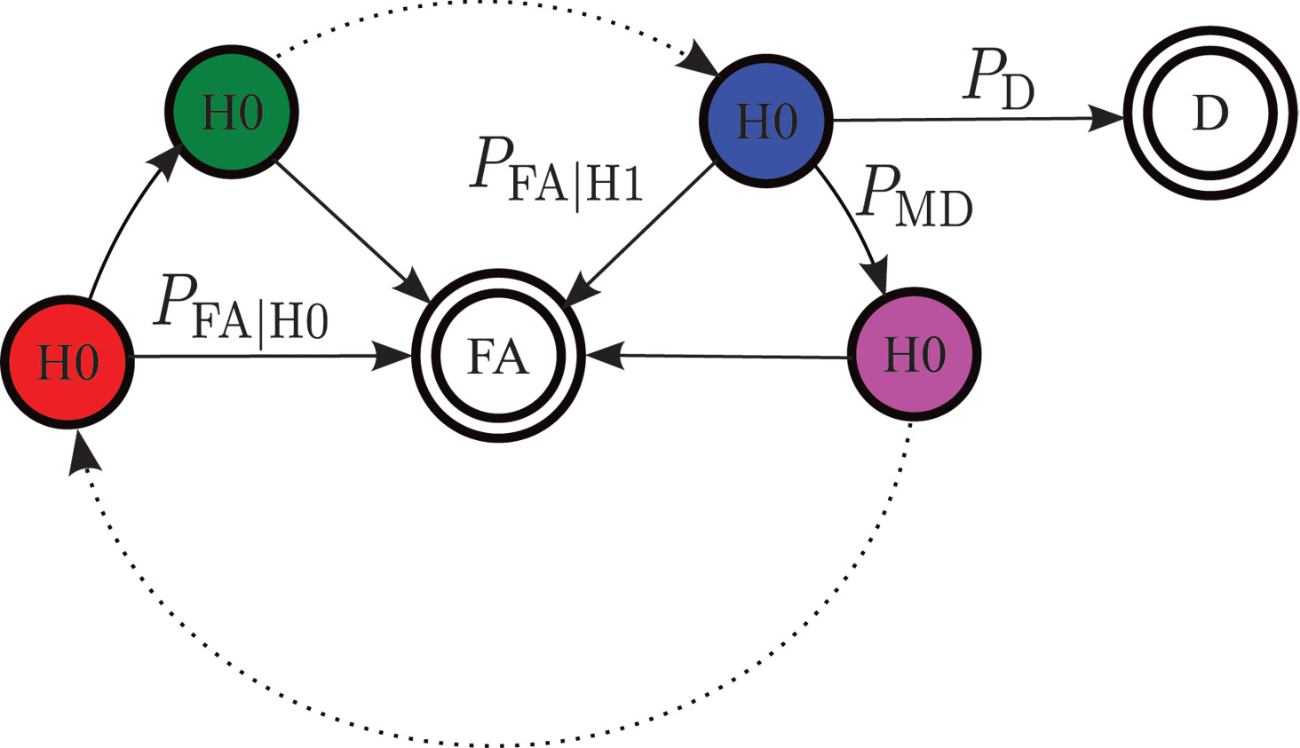
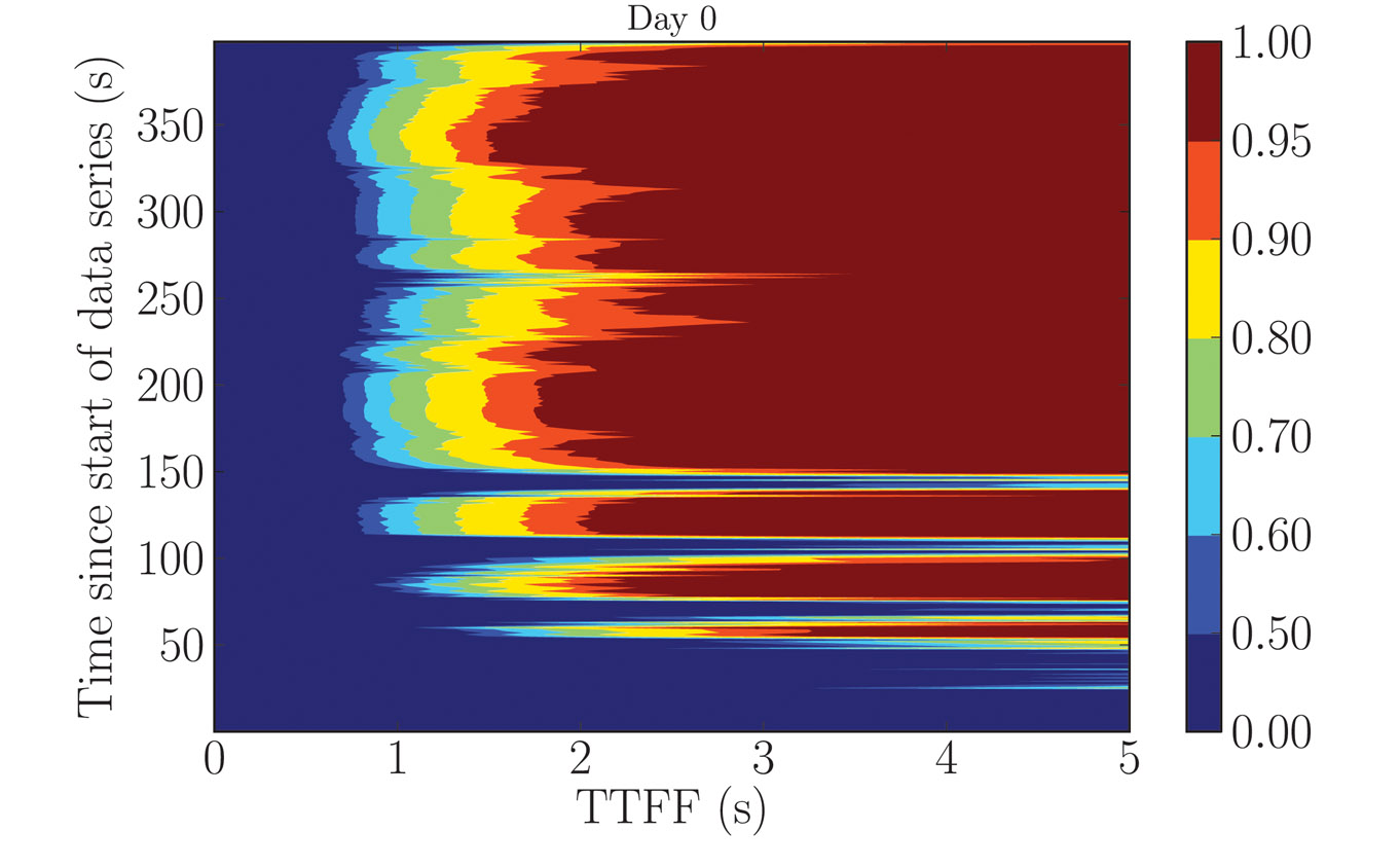
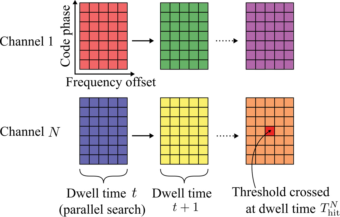
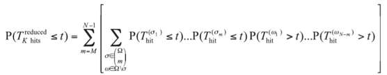
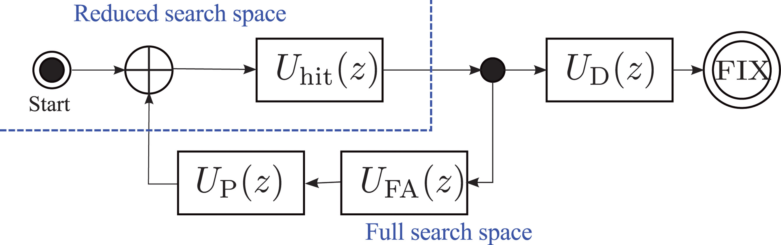
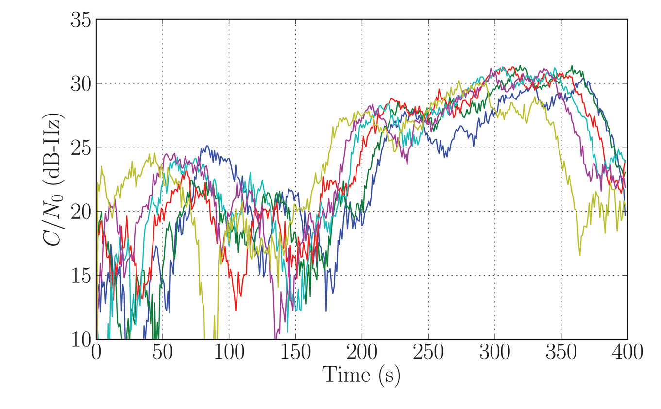
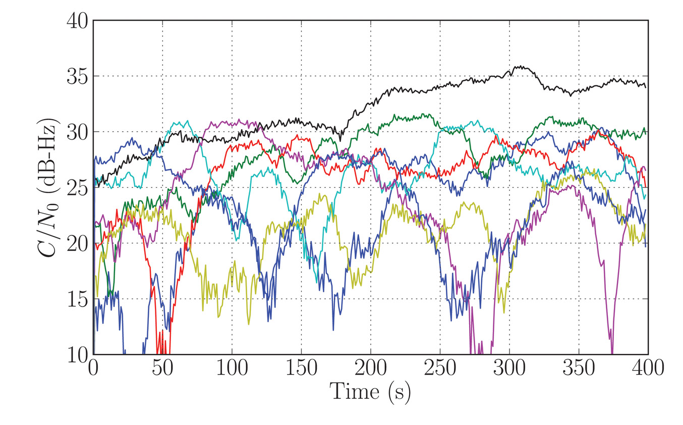

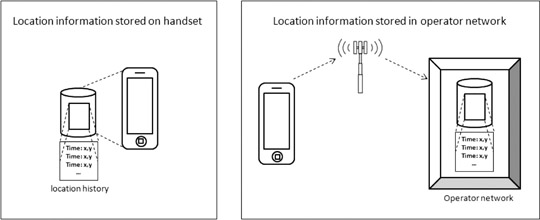


 Microsoft is contributing to the latest location privacy jitters. Missteps by Microsoft, Apple, and Google have the potential to dampen uptake of location solutions. Microsoft published the estimated locations of millions of laptops, cell phones, and other devices with Wi-Fi connections. The location database was assembled by Microsoft’s access to Windows phones and by vehicles that drive streets and record Wi-Fi signals accessible from public roads. The data were published on Microsoft’s