To solve the LightSquared versus GPS controversy, Javad Ashjaee, president and CEO of JAVAD GNSS, has appealed directly to President Obama to discontinue the encryption of P-code, the restricted military GPS signal. His comments came in the context of the LightSquared/GPS interference imbroglio, as part of his solution to the conflict over spectrum. “This policy is not helping national security. It is hurting both precision users and the broadband project. We need more broadband, for global, fast, and inexpensive real-time kinematic (RTK) GPS.”
Ashjaee, a longtime leader in high-precision GNSS equipment, made the remarks during a panel discussion at the Esri Survey Summit, and expands upon them in a video posted on his company’s website: “A Solution for LightSquared.” In the video, he calls the LightSquared saga “a good thing, because it brings the issue of in-band interference to many GPS users, especially surveyors and high-precision users.”
He goes on to address three issues: collateral damage, why high-precision receivers are more affected by the LightSquared attack, and finally a proposed solution to the problem.
In the first section, he disputes the assertion that LightSquared interference to 5 percent (surveyors) and 1 percent (military) of GPS users should be tolerated as collateral damage. “When you add substance to the numbers, you see how quickly this argument fails. The military is the backbone of our national security, and high-precision users are the backbone of our financial security and growth.”
On the second topic, he gives two reasons why high-precision receivers are more affected by the LightSquared signal, briefly summarized here as:
the crucial importance of the arrival time of the signal edges; the edges are first to be distorted by interference. Narrow filters, proposed as a solution by LightSquared, also blur the signal-edge shape.
the encryption of P-code on L1 and L2 bands, degrading their effectiveness by a factor of 1,000, according to Ashjaee. “Encryption does not do any good to anybody.”
As his solution to the problem, Ashjaee says Lightsquared should stay further away from the GPS signal, and use a cascade of filters; secondly, he calls on President Obama to discontinue P-code encryption, at least until the new L2 signal is operable in 8 or 10 years. “This would make GPS less vulnerable to the LightSquared project and others like it.”
In a subsequent conversation with GPS World, Ashjaee likened the P-code situation to that of selective availability (SA), another U.S. government effort to restrict use of high precision. Ashjaee recalled campaigning vigorously against SA in 1991, with full-page ads in GPS World depicting the Mona Lisa painting with many missing parts. “Selective availability is a step backward in providing the best of this excellent work [GPS] of science and art. As the leader in GPS technology, we consider selective availability as being neither good science nor good politics,” the ad copy reads.
Ashjaee adds with a twinkle, “[A former director of the GPS Wing] told me that a high general in the Air Force had that ad pinned to the wall behind his desk. Why? Who knows. Perhaps he agreed with it.”
SA was discontinued in May 2000.
(As an interesting historical side-note, in an adjacent ad in the same January 1991 issue, the company advertised “Ashtech’s True P-Code Advantage.” At that time, P-code was not encrypted. The copy reads:
“GPS was designed as a dual-frequency system and the Ashtech P-12 GPS receiver enables users to take full advantage of GPS capabilities. Dual-frequency reception eliminates ionospheric refraction effects, so medium-to-longer baselines can be measured more accurately.
“High-quality P-code measurements on both bands also enable shroter station occupation time, further increasing productivity for survey crews.”
“P-code correlation produces carrier-phase measurements of higher accuracy because of significantly higher SNR over conventional codeless techniques. This, combined with the P-12 receiver’s ability to measure full-wavelength L2 carier-phase, allows nearly instantaneous integer cycle-phase ambiguity resolution for kinematic survey, precision navigation, and other applications.
“Unlinke conventional codeless techniques, ‘true P-code’ tracking provides inherent immunity from jamming for uninterrupted tracking in areas of high interference.”)
“The U.S. policy of national security and P-code is 30 years old,” Ashjaee resumes. “This policy was devised at the time we were head-to-head in the Cold War with Soviet Union. They had missiles targeted at us, we had missiles targeted at them. That’s why we encrypted the P-code. But this situation is gone. There is now an agreement between Obama and [Russian president] Medvedev that citizens of the two countries can have 3-year visas to visit each other. Our missiles are not targeted at each other.”
“Since the inception of GPS, there is no shred of evidence that GPS has ever been used to attack any U.S. national security, let alone its P-code signals.”
Further, Ashjaee pointed out, “At that time, GLONASS did not exist, and we did not want them to use our system. Now GLONASS exists, and its signal is arguably more robust than GPS.”
Ashjaee called on President Obama to turn off P-code encryption. “This policy is not helping national security. It is hurting both precision users and the LightSquared project, which we all desperately need. We need more broadband. They know the system is not good, and they want to put another clear code [on L2]. It will take 8 or 10 years. Turn off encryption temporarily until we have it. Encryption can be turned on in a fraction of a second whenever needed.”
“Turning off P-code encryption not only makes the GPS signalmore robust to LightSquared, but also protects it against all kind of other interferences, including harmonics of innocent signals like harmonics or radio stations.”
He embraced the use of wideband communication between base and rovers for RTK GPS. “We have base and rovers, with VRS networks. The corrections must be transmitted from base to rovers. Now we have a mess of communications: UHF (different in every country, difficult to certify in every country), spread-spectrum, VHF, Ethernet, WiFi. These are kludgey communications. If we have broadband, similar to Lightsquared, we have RTK globally, fast, and inexpensive.”
In a separate conversation with GPS World, another expert in high-precision use confirmed that “we have worked very hard in the past, when bandwidth was much more expensive, to minimize the bandwidth required to send differential GPS corrections with minimal latency. Sensor fusion has mitigated the latency issue as well. As robotics applications increase, not only base-rover communications but tons of data relevant to precise positioning, sensor fusion, including vision, RF ranging, path planning, mission planning, obstacle detection, and so on, will be needed. Industrial, scientific, and medical (ISM) band spread-spectrum and ultra-wideband (UWB) ranging systems have a lot of problems that 4G systems could alleviate.”
“We need a coalition to save GPS and Lightsquared,” concluded Ashjaee. “It’s a nice complement.”
“Broadband would be a good help to our industry, and to our technology. We want global, universal wideband communication, either through towers or satellites, or through any means to transmit base station or VRS network corrections to rovers.”
Ashjaee offered to debate the P-code encryption issue with representatives from the GPS Wing, State Department, Department of Defense, PNT ExCom, and others, at the annual GPS World Leadership Dinner, held during the ION-GNSS conference each September. “It will be a very lively debate,” he said. “Add Tom Stansell, too. And representative of LightSquared.”
The U.S. Departments of Defense and Transportation declared their strong opposition to the proposal of LightSquared Subsidiary LLC to operate a nationwide broadband service within the spectrum immediately adjacent to GPS signals, in a letter sent on June 14 to the National Telecommunications and Information Administration (NTIA). The agencies acted on behalf of the on behalf of the National Executive Committee for Space-Based Positioning, Navigation, and Timing, which they are responsible for co-chairing.
The Departments asked the NTIA administrator to advise the Federal Communications Commission (FCC) to continue to withhold authorization for LightSquared to commence commercial service per its proposed deployment of a terrestrial service within the 1525-1559 MHz bands. LightSquared’s proposal is to deploy a network of 40,000 base stations along with some satellite coverage over 139 major markets in the United States.
According to their official statement, “The Departments continue to support the National Broadband Plan, but cannot do so at the expense of a global, ubiquitous utility such as the Global Positioning System. The Departments encourage further assessment of any alternative spectrum and/or signal configuration plans.”
The DoD/DoT letter was sent just prior to the original deadline for the final report of the Technical Working Group commissioned by the FCC to research and recommend on this matter. Certainly, the respective signers were cognizant of the contents of that report, at least on the test results regarding interference with GPS. As it turned out, on June 15 LightSquared asked for more time, and was granted a two-week extension. The final report was filed with the FCC on June 30.
The Departments’ position followed an interagency review of the findings of the National Space-Based Positioning, Navigation, and Timing Systems Engineering Forum (NPEF), tasked to assess the GPS impacts of LightSquared’s deployment plan as originally filed. The NPEF determined that, if permitted to operate as originally planned, LightSquared’s signals would significantly interfere with GPS users and, as a result, impact national security, economic security, and public safety nationwide. The NPEF report served as working material for the TWG report.
The NTIA Administrator forwarded the letter and report to the FCC Chairman on July 6. These materials can be found at www.PNT.gov.
It’s July, which means big news is slow to come by — and it is the opportunity to examine what will drive the location-based services market for the rest of 2011…and beyond. So far, consolidation is continuing, with Nokia combining digital mapping giant Navteq into a single LBS unit. In addition, strong entries into the machine-to-machine market include Iridium, while AT&T seeks to increase market share. Privacy issues were a big topic in the first part of the 2011, but will they hamper market growth the rest of the year?
Nokia to Consolidate Navteq into Location-Based Services Unit
In a move that looks like a strategy overhaul, Nokia plans to combine its Chicago-based Navteq digital mapping unit with its location-based services business. The new location and commerce division will be led by Michael Halbherr, who told LBS Insider in April that he was involved in Nokia’s $8.1 billion decision to acquire Navteq in 2007.
Nokia had touted that it had a “hands-off” approach with Navteq, unlike competitor TomTom, which incorporated its Tele Atlas mapping unit so much that the TA brand is no longer visible.
Halbherr told LBS Insider he predicted the demise of the portable navigation system early on, a market that competitor TomTom has been finding difficult recently. Navteq maps power Nokia’s Ovi Maps service for smartphones. Yahoo and Microsoft also incorporate Navteq digital mapping into their offerings.
Privacy Legislation Looks For Consumer Consent
New legislation aims to preclude such companies as Apple and Google from using customer’s location data without their consent. Senators Al Franken, D-Minn., and Richard Blumenthal, D-Conn., co-sponsored the bill, called the Location Privacy Protection Act of 2011.
Franken honchoed a Senate Judiciary Subcommittee on Privacy, Technology, and the Law hearing that grilled Google and Apple executives in May. The uproar about consumer privacy arose in April at a California LBS application developers’ conference when companies indicated that customer’s privacy data was collected and shared.
How this legislation, if passed, will affect the industry is not known. But it has raised eyebrows in several market sectors. Thilo Koslowski, Gartner vice president, told attendees at an automotive telematics conference last month that privacy is a big concern to auto makers who want to incorporate LBS-type of connectivity into their new vehicles. Koslowski went further when he said that not only do consumers not want social media in their vehicles, the privacy factor is not going away — and the industry needs to take notice of that.
Iridium Forging Into M2M Markets
Saying the machine-to-machine market constitutes its fastest growing segment, McLean, Va.-based Iridium Communications has partnered with several industry companies to grow beyond its government markets.
“M2M in 2010 exploded for us in 2010, a real tipping point. In short, we reduced the size of the 9602 [short burst data] module to the size of matchbook, so the much lower price point allowed us to win a bunch of new programs,” said Patrick Shay, Iridium vice president and general manager for data services.
Shay, an industry veteran who worked at Motorola, Rand McNally and Hughes Telematics, said that Iridium plans constellation enhancements in 2015. “It’s a one-for-one [satellite] replacement with backward compatibility and no service disruption,” he said.
Such big M2M names as Kore Telematics, Digi International, and SkyBitz have become Iridium partners. Kore integrates satellite connectivity into its Prismpro unit.
One Iridium partner, DeLorme, said it is rolling out a personal communicator this fall with two-way satellite messaging, SOS capabilities, remote tracking and Android smartphone interface so messages can be posted to Twitter or Facebook. The unit will go for $249.95 and have subscription fees starting at $9.95 a month.
Editor’s Note: The August issue of GPS World will carry an article about Iridium certifying Cubic Global Tracking Solutions’ Global Sentinel System.
AT&T Location Information Services Focusing on Enterprise Market
AT&T Location Information Services is greatly expanding its location marketing, particularly in M2M, with its partners Loc-Aid Technologies and TechnoCom Corp. The company announced the partnerships at its developer summit in January.
The company is focusing on the enterprise market because consumer location-based services have been a tough go for AT&T. The enterprise/M2M market has been a good one for AT&T and its network-based location systems, said John Booth, AT&T LIS senior product manager.
The interoperability with the other carriers helps to grow the market, Booth said. “Historically, a customer had to work with one carrier and that limited them,” he said.
Booth says there are benefits in using a network-based location solution because it prevents users from needing to download applications or use a specific platform in order to be located. The services are both device and network agnostic, he said.
Loc-Aid is working with AT&T on its Location-as-a Service offering where businesses can access a customer’s location based on requirements or events. TechnoCom and AT&T are creating location and messaging products for the enterprise market.
AT&T is working with Road America, a roadside assistance service provider, for a network-based application for location capability in the event of an accident or break down. The service, called LocateMe, is a cross-carrier offering that links to Road America’s 24-hour response centers.
AT&T is working on integrating other location technology into its network service offerings, Booth said. “We are working on a number of applications besides assisted GPS [and cell ID] to include Wi-Fi and RFID. We want something that works in whatever the environment — airports or railroads,” he said.
In addition to call center and transportation logistics, which is AT&T’s strong areas, emerging markets include fraud prevention and even truancy monitoring. “School districts get millions of dollars in funding based on student attendance. It’s a natural location market,” Booth said.
In addition to the truancy monitoring market, regular parolees and bail bond holders constitute a huge potential market. AT&T estimates there are 5 million parolees nationwide and 7 million bail bond holders.
Carriers Still Focal Point for LBS Implementation
For years there have been arguments about who is driving the mobile information market for LBS: Is it the carriers? Auto manufacturers? New media companies such as Google? Despite all of the talk, companies still are trying to align themselves to offer the carriers’ capabilities to implement LBS.
The recent Alcatel-Lucent partnership with Polaris Wireless and Thales Alenia Space is an example of companies tailoring E911 type of location capability and marketing for carriers. The three companies have partnered to pursue business with Tier 1 wireless operators in the United States and other regions, said Bhavin Shah, Polaris Wireless vice president of marketing and business development.
“Alcatel-Lucent and Thales Alenia Space have a working relationship based on the former’s prior part-ownership of the latter. Alcatel-Lucent and Polaris Wireless have pursued a closer relationship based on shared interests in promoting their respective location solutions to wireless operators,” he said. “Recent developments and announcement of the partnership were triggered by impending Tier 1 LTE decisions,
and the fact that the partnership enables a quicker time to market than ALU building a location solution on its own, and Polaris Wireless and Thales Alenia Space approaching Tier 1 operators directly without a larger infrastructure partner.”
Alcatel-Lucent is the platform provider and direct interface with the customer (network operator). ALU provides all hardware, middleware, and conducts sales, support, operations, and billing. Polaris Wireless provides network-based location technology and network interfaces, including Polaris Wireless Location Signatures (Polaris WLSTM) and other location technology, such as Enhanced Cell-ID. Thales Alenia Space, with its expertise in satellite positioning, provides handset-based (GPS) location technology.
Recent events, some of them summarized here, may appear to have dealt setbacks to LightSquared, the boundless opportunist of wireless broadband that just happens to interfere with GPS. But the company has not run out of moves yet. Would you, if you had $20 billion at stake? The latest gambit, led by lawyers and cloaked in jargon, appears to be an end-run around the U.S. government to appeal to the International Telecommunications Union, which has ultimate and international authority over spectrum. Watch out, GLONASS and Galileo — and U.S. troops operating in foreign theaters.
GPS World has received copies of three “fact sheets” authored by two lawyers and a strategic consultant. The documents are addressed to ITU-R WP 4C, the International Telecommunications Union Working Party that handles mobile satellite services (MSS) and radio determination satellite service (RDSS spectrum) and orbits. One document is titled “ Compatibility between Complimentary Ground Componenet in the 1525–1559 Mhz and 1626.5–1660.5 Mhz Bands and Other Service.” All three documents appear to be cover sheets for longer treatises, and their language and citations are not entirely clear to me, as my legal and regulatory background leaves something to be desired.
However, they announce their purpose as “to modify and refine the example methodology to calculate aeronautical mobile satellite (route) service spectrum requirements,” and “to address ongoing Integrated Mobile Satellite Service Complimentary Ground Component compatibility matters,” and finally “to update the Integrated Mobile Satellite Service Complimentary Ground Component technical characteristics based upon the most recent information regarding CGC deployment plans in this frequency band.”
One source familiar with the documents, who did not wish to be named, commented that “One should interpret what LightSquared is doing with ITU as a bellwether indication of intent to use the whole band at the full authorized power, no matter how they spin ‘protect GPS’ in their press releases.
“At first blush, the filings look innocuous; let me assure you, they are not. This is the first salvo. Watch what they do, much more than what they say.
“These are fact sheets intended to inform the U.S. government that LightSquared intends to develop papers with the intent to get the U.S. government to approve the papers to be sent to the ITU WP-4C, the Working Party that handles MSS and RDSS spectrum & orbits. The ultimate goal is to work internationally to allow LightSquared to allow ancillary terrestrial component (ATC) broadcast globally.”
In other developments, going now in reverse chronological order, from most recent to early June:
Congressional Activity
On June 23, the U.S. House of RepresentativesAppropriations Committee approved the fiscal year 2012 Financial Services and General Government Appropriations bill. One amendment to the bill prohibits funding for the Federal Communications Commission (FCC) to remove conditions on or permit certain commercial broadband operations until the FCC has resolved concerns of harmful interference by these operations on GPS devices. The amendment was adopted on a voice vote. More details here.
Previously, on May 27, the U.S. House of Representatives passed a bill stating that the FCC shall not provide final authorization for LightSquared operations until Defense Department concerns about GPS interference have been resolved. The bill then went to the U.S. Senate for its action.
The House actions and a letter to the FCC signed by 32 U.S. senators may presage a showdown over the issue between Congress and the president, who has promised increased broadband access. A 4G wireless network providing this access could be facilitated by LightSquared sales of service via its tower transmitters to wireless carriers. LightSquared has already signed a $20 billion, 15-year deal with Sprint.
Money Talks
A report on “The Economic Benefits of Commercial GPS Use in the United States and the Costs of Potential Disruption” was presented by during a June 21 webinar sponsored by the Coalition to Save Our GPS. The report estimates that “the direct economic benefits of GPS technology on commercial GPS users are . . . over $67.6 billion per year in the United States,” but also that ““the direct economic costs of full GPS disruption to commercial GPS users and GPS manufacturers are estimated to be $96 billion per year in the United States.” Final Report Withheld
At the last minute of a June 15 deadline for the final Working Group report on interference, LightSquared asked for a two-week extension. Federal regulators granted the request, and the final report is now due on July 1.
A spokesperson for the Coalition to Save Our GPS revealed that “The Working Group results show devastating interference to GPS and no proven method of mitigation. Delay will not change these results. These results are the same results the FCC had had before it granted the waiver.”
Some Solution. Three days after requesting the delay, LightSquared announced it had solved the problem, by proposing to broadcast only from the lower end of its permitted spectrum band. GPS experts countered that this would still disable the functioning of high-precision receivers.
“This comes out of the blue, without the knowledge, agreement or consensus of the industry group studying the problem,” riposted the Coalition to Save Our GPS. “That may well be because virtually nothing has actually changed in this “new” proposal relative to what LIghtSquared pledged at the outset of testing. The power levels don’t change. Nor do the frequencies. In fact, the only thing that has changed is the order in which the channels within the band adjacent to GPS would be deployed.
“LightSquared’s announced “solution” has two components:
“1. LightSquared acknowledges that “[e]arly test results indicated that one of LightSquared’s 10MHz blocks of frequencies poses interference to many GPS receivers.” LightSquared states that for “the next several years” it would not operate in this band – which is directly adjacent to GPS spectrum and is referred to as the “upper MSS band.” During this period, LightSquared would commence operations in a second 10 MHz block of the MSS band , referred to as the “lower MSS band,” slightly further away from GPS.
“2. According to the proposal ‘LightSquared will modify its FCC license to reduce the maximum authorized power of its base-station transmitters by over 50 percent. This action will limit LightSquared to the power it was authorized to use in 2005.’
“This so-called solution is not a solution in any shape, form or fashion,” continues the Coalition. “This is not a move to an alternative frequency band. Nor is it a reduction in power relative to what has been tested from the beginning. The “solution” would cause massive disruption to many critical U.S. economic sectors, initially including public sector users of high precision GPS, later followed – af
ter “the next several years” — by other GPS users. The only real solution to the LightSquared interference problem is to move out of the MSS band altogether."
The Air Transport Association and the Aircraft Owners & Pilots Association told Congress that the only acceptable mitigation is for LightSquared’s operations to be moved outside of the L-band and away from GPS. “With so much of the early evidence showing that LightSquared’s proposed network would potentially endanger nearly every flight operating in U.S. airspace, it seems evident that no further development of this system can be allowed.”
Military Report Calls for FCC Retreat
The National PNT Engineering Forum concluded after testing classified and GPS receivers under LightSquared terrestrial transmission conditions: “Significant concerns remain that operation of an ATC integrated service as originally envisioned by the FCC cannot successfully coexist with GPS.”
The NPEF report calls for rescinding the FCC waiver for LightSquared terrestrial transmissions, conducting more thorough studies on impacts, and revisiting the 2003–2010 authorizations. The group tested a variety of military receivers under classified categorization, also known as “government receivers.” Rebuttals Distort Record
Claims by LightSquared’s Carlisle and FCC chair Julius Genachowski, that the GPS industry knew long ago about LightSquared’s plan for powerful terrestrial transmitters, contradict the truth. Examination of FCC filings show that the GPS industry knew about and agreed to a plan by a previous ownership of the company, for a different purpose, with a different business concept, and employing a completely different technological approach, one that would not have harmed GPS transmissions and disabled GPS users the way the current LightSquared plan does.
The terrestrial broadband operations first unveiled in November 2010 cannot be described as ancillary to the purpose for which Lightsquared predecessors Motient, MSV, and SkyTerra received their spectrum and licenses — that is, to provide a service that was primarily a mobile satellite service. The November letter to the FCC described a new business model that turns the original concept on its head. LightSquared for the first time revealed plans to build a “nationwide network of 40,000 terrestrial base stations,” and stated that “the capacity of its fully deployed terrestrial network across all base stations will be tens of thousands of times the capacity of either of [its] satellites.”
The deviations from established policy required to accommodate LightSquared’s new business model are not technicalities. They represent a fundamental change to a complex and interrelated set of rules that were carefully designed to protect GPS users from interference.
The predecessor companies had to protect their own primary satellite operations from interference. The protection that their own satellite operations required was also sufficient — at that time — to protect GPS receivers. The terrestrial network and powerful signal LightSquared now proposes bear no resemblance to the operations the FCC authorized in 2003.
At its June 9–10 meeting, the National Space-Based Positioning, Navigation and Timing (PNT) Advisory Board found that GPS services cannot be assured if the LightSquared plan is approved, and that the only viable option for continued availability of GPS as well as new wireless broadband is to find another spectrum for LightSquared not adjacent to the GPS frequency.
The formal recommendation reads: “The provision of GPS services cannot be assured if the LightSquared proposal for satellite and terrestrial broadband provision using the MSS L-Band receives final approval.
“The only reasonable and viable option to continue ubiquitous availability of GPS and the provision of a new 4G wireless broadband capability would be for the FCC to assign an alternate frequency spectrum to LightSquared that has little or no probability of affecting the delivery or utilization of GPS/GNSS services.”
During its meeting, the Advisory Board heard directly from one representative of LightSquared, the company’s executive vice president, regulatory affairs and public policy, Jeff Carlisle, and from Jim Kirkland, vice president and general counsel, Trimble Navigation, speaking on behalf of the Save Our GPS Coalition. "Without knowing otherwise," commented one observer, "one might have thought they were talking about two different sets of FCC actions. Their interpretations of FCC actions were completely orthogonal to each other."
During the discussion, one Advisory Board member, a former governor of the state of Wyoming, told presenter Jeff Carlisle of LightSquared, “Your definition of mitigation seems more tied to a legal argument than a common-sense argument.”
Other speakers on the LightSquared/GPS panel included Dean Bunce, co-chair of the National PNT Engineering Forum (NPEF), which has had responsibility for testing various classified GPS receivers under LightSquared conditions; and Robert Frazier of the Federal Aviation Administration (FAA) Spectrum Planning and International Office.
Another observer at the Advisory Board meeting opined of the LightSquared presentation and subsequent replies to questions from board members, “I’ve seen weasels before, but not like this. Misinformation, mis-statements, reversals and take-backs, outright lies.”
Tests Slam Hi-Precision Receivers
Data from Las Vegas field tests show that wide-bandwidth, high-precision GPS receivers started feeling the effects of the LightSquared transmission about 1,800 meters from the tower. Medium-bandwidth high-precision GPS receivers started feeling the effects of the LightSquared transmission at about 1,200 meters from the tower. In each case, there was about a 200-meter buffer from when the GPS receivers started to feel the effects of the LightSquared transmission to the GPS receiver being jammed, at 1,600 meters and 1,000 meters respectively. For further details, see this article.
GPS World has received further details of the tests but not an authorization to publish them yet.
Deere & Company, a major provider of precision agriculture equipment and services, notified the FCC on May 26 of substantial interference with its GPS receivers by the LightSquared signal. Deere receivers registered impact of and interference by the LightSquared signal as far away as 22 miles from a transmitter. Further, the company has found no practicable technical solution to the problem.
LightSquared Prospects Dimming. Concerns by government and the private sector about GPS interference from LightSquared’s proposed wholesale LTE service accelerates. Government experts just reported that interference with GPS occurred in high portions of LightSquared’s spectrum bands and little in the lower spectrum. The National Space-Based PNT Advisory Board’s tests showed that some GPS receivers lost signal strength while others were fully disabled by LightSquared’s signal. FCC Chairman Genachowski, under fire for granting LightSquared a conditional waiver, has reiterated that he will not permit LightSquared to begin commercial service without first resolving concerns about potential interference to GPS devices.
Genachowski hit back at the GPS community in a letter to Sen. Charles Grassley, “It should be no surprise to anyone involved in the LightSquared matter that the company was planning for some time to deploy a major terrestrial network in the spectrum adjacent to GPS.” Members of the National Space-Based PNT Advisory Board have stated that they and the GPS community were not properly notified when the FCC removed the limit on the number of base stations deployed on this spectrum. And so it goes on. (See also LightSquared, FCC Rebuttals Distort Record.)
Getting Intimate. Mobile phones are the most personal computing devices. How personal? iPass conducted a study of 3,700 mobile employees at 1,000 enterprises worldwide. Sixty-one percent of these mobile workers sleep with their smartphones and 43 percent of those within arm’s reach. It gets worse. 58 percent of those that sleep with their phones at least occasionally, check it during the night. Not surprisingly, almost a third of mobile workers say their relationship with their smartphone causes friction with their partner. I’d say.
Frienemies. In a newly extended agreement, Google will continue to provide archrival Apple with map and search capabilities. This kills rampant rumors that Apple will have a home-grown mapping database ready in the near term. In March, AppleInsider discovered an Apple job listing for an iOS Maps Application Developer to “radically improve” Apple’s location-based services. Even for Apple, a mapping database will take time to develop.
App Stores Aren’t the Holy Grail. App developers whose marketing strategy starts and ends with getting onto app store “shelves” need a reality check. With more than 200,000 apps on Google’s Android Market and 350,000 on the Apple store, it is hard to stand out. According to Distimo, 20 percent of free applications and 80 percent of all paid applications have been downloaded less than 100 times in the Google Android Market, worldwide. Ninety-six applications have been downloaded more than 5 million times, with Google Maps the winner, with more than 50 million downloads in the Android Market.
Traffic Targeted. Navteq will begin delivering its traffic services in Transport Protocol Expert Group (TPEG) standard format to enable location-targeted traffic services with radius search capabilities and user authentication and session management. The format allows more targeted data to be delivered in smaller file sizes.
Mobile Advertising Flying High. Many of the location content providers are counting on monetizing with mobile advertising, and things are looking good. AdMob is receiving more than 2.7 billion mobile ad requests daily, spanning more than 80,000 mobile applications and websites. Now they are introducing ads for tablet formats. Ad Mob was purchased by Google last year for $750 million.
Snippets
Nokia is ending the confusion of its dual names by killing the Ovi brand. Ovi maps, Ovi e-mail, Ovi music, Ovi store, and other Ovi products will continue to operate under the Nokia brand name.
Industry-backed Future of Privacy Forum is launching a new ApplicationPrivacy.org website to help developers create their own privacy policies. Location privacy concerns have so far been focused on the big players like Apple and Google, but app providers have a critical role.
Firefox for Android now includes a “do not track” tool that signals all web pages, images and advertisers that the user doesn’t want to be tracked.
Taipei officials are ordering Apple and Google to offer free seven-day mobile app trials in alignment with Taiwan’s Consumer Protection Act.
Google is raking in more than 97 percent of U.S. mobile search spending. Yahoo and Microsoft’s Bing share the remainder.
Monetizing with Nothing. The Inside Virtual Goods report estimates $1.6 billion dollars was spent by game players on virtual goods last year and is predicting a 40 percent increase in 2011. There is a gender factor. MocoSpace, mobile entertainment provider, reports that although the percent of male players (53 percent) is only slightly higher than female, men account for 90 percent of all virtual goods purchased in their games. Can you lend me your sword, sir?
As touchscreens get larger in vehicles, so does the thought that location-based services should be included. At the Telematics Detroit 2011 conference, while most industry observers say that some sort of advertising will soon be in every vehicle, not everyone is sold on having advertising flashed to drivers as they go by a business.
NOVI, Mich. — While the automobile may become the ultimate mobile communication device, it remains to be seen how big a role location-based services will play in this new development, said an analyst here at the Telematics Detroit 2011 conference.
“We have been looking into LBS for 10 years. The idea of driving by a store and getting a coupon is one that [consumers are] cool to. There is a big privacy issue that may backfire on companies,” said Thilo Koslowski, Gartner vice president. “In our studies, social networking still scores low for the average car consumer. The people who are buying cars are not thinking about Twitter while driving their cars — though the numbers are higher among younger drivers. Navigation is still the top feature that consumers want.”
Because of larger screens going into many vehicles, LBS seems like a natural advertising fit, but Koslowski says it will be more along traditional display-type marketing models.
Koslowsi said the biggest competition the auto industry has is the smartphone or other consumer mobile device. “We will see growth in vehicle application on the Android platform, while Apple will be leveling off. [Research in Motion] will have a lower share.”
The risk for auto manufacturers is getting too many gadgets and applications into a car. “There is a lot of risk, and hype, when manufacturers try to get too much into a vehicle. Consumers will expect certain connectivity features in the future,” Koslowski said. “Many of these innovations will occur, for the premium brands, in 2013 — that’s just around the corner in automotive years.”
Overall, Koslowski says telematics vendors and automakers should balance their priorities and opportunities. “They should seek new partnership models and strive for controlled openness [of systems], which means not complete control. The automobile will emerge as the ultimate mobile device,” he said. “There are several challenges about the connected vehicle. It is too expensive — not a must-have for consumers. Manufacturers have an unrealistic expectation.”
One of the companies wanting to get its services into a vehicle, Verizon Wireless, showcased its “Rule the Road” initiative at the conference. Rule the Road, which leverages the 4G and LTE networks, features a suite of services such as Wi-Fi hotspots, vehicle diagnostics, navigation, and traffic and safety/security.
“What you can and can’t do [in a vehicle] are important. Most navigation systems have long wait times to reroute; in the LTE world, traffic date and rerouting are immediate,” said Janet Schijns, Verizon Wireless vice president, business solutions group, who previously worked at Intel and Motorola’s enterprise group. “The car is the most powerful mobile device.”
Schijns says the car will be a great mobile communications device because owners are more loyal to it than another consumer product. “The average person used to own a computer for five years — that time continues to be reduced. They are less loyal to their mobile devices,” she said. “But people are loyal to their cars. They are the longest-life mobile device.”
Manufacturers continue to innovate and roll out products tailored to the automotive telematics market. CSR made several announcements, and exhibited, at Telematics Detroit.
One of its products, the SiRFstarIV GPS engine (GSD4e 9500), features active jammer removal technology that precludes in-band interference in cars.
“It’s the same receiver adopted by Samsung on their Galaxy mobile phones,” said Lars Boeryd, CSR director of automotive marketing.
CSR also said that Renesas Electronics Corp. adopted its location and connectivity hardware for its automotive infotainment platform. The company also is tailoring its CSR6000 Wi-Linx to automotive manufacturers to turn cars into rolling Wi-Fi hotspots, which seemed to be a big deal during sessions here.
M2M Constitutes Large Location Market
One bright spot in the whole location market is the burgeoning machine-to-machine segment. Some of the numbers are big: 4.4 million MRM units deployed by 250,000 companies, said Clem Driscoll, CJ Driscoll & Associates founder, in his annual presentation at Telematics Detroit.
Driscoll still believes that the Contran 245 Brazil law that requires every new vehicle in that country to have a GPS-enabled system will be huge for the industry. However, he concedes that the South American country has been slow to implement this law.
Trucking fleet markets, which have been in the doldrums since a 2008-2009 slump, may be heading back toward profitability because of new government regulations that require electronic onboard monitoring recorders, or EOBRs, Driscoll said. “These simple EOBRs will be in the $300-$500 range,” he said.
Kore Wireless Group, which exhibited at Telematics Detroit, said they bought Melbourne-based Mach Communications Pty Ltd., a wireless M2M network provider. “The growth in the Asia-Pacific market is going to triple. We wanted to have a solid presence in that area,” said Pete West, Kore Telematics business development manager.
Kore, which partners with Vodaphone and Iridium, is looking at such future M2M markets as insurance and health-care diagnostic monitoring, West said.
Another M2M company, Telenor Connexion, announced that it had partnered with Italy-based Octo Telematics, which specializes in telematics services and systems for the insurance and automotive market. “The company has seen aggressive growth, particularly in emerging countries in Eastern Europe. In Europe, the market is pay-as-you-drive. It’s a progressive way for building new customer segments that did not want restrictions in Europe,” said Per Lindberg, Telenor Connexion global business development executive.
Telenor Connexion, which has a long-established relationship with Volvo Trucks and many other companies, now builds its own M2M platforms.
In other conference news:
Overused conference word alert! The word “experience,” as in “driving experience,” or “consumer experience,” is way overused. Just like the 1990s’ “value-added” and ”best-of-breed” or “solution” (instead of product). A prominent wireless exec used the word “experience” more than a dozen times in her 40-minute presentation.
Telematics Detroit 2011 had a big crowd, which was not bad in a so-so economy in a remote location.
Location privacy issues have the power to put the skids on our industry. When I stepped into the Where 2.0 show, little did I know I was about to see Apple publicly open its kimono, reveal its location collection practices, and further fuel public and government outrage on location privacy. Apple doesn’t stand alone as Google also stores similar data on Android devices. And in a smaller breach, TomTom’s user location data was sold to the Netherland’s government, helping to optimize the placement of speed traps. Congress responded by hauling Apple and Google into a Congressional subcommittee meeting. Senator Patrick Leahy captured the hearing’s mood when he said, “American consumers and businesses face threats to privacy like no time before.” He went on to say that he was “deeply concerned” about the reports that iPhones and Android devices were “collecting, storing, and tracking user location data without the user’s consent.”
Apple’s recent revelation was that its iOS operating system stores user location data in a hidden file. The location was being provided to iTunes during back-ups, giving Apple a log of a user’s movements and activities, for up to a year. A new iOS version reduces the log to a week of data and ends the back up to iTunes. The cache can be eliminated by disabling the device’s location feature.
Leak from Google Skyhook skirmish. Larry Page, now-CEO of Google, sent an e-mail last year to top executives with the news that Motorola had chosen to use Skyhook, and not Google, location services. According to e-mails leaked to the San Jose Mercury News, Google executives responded by emphasizing the importance of collecting location data from smartphones, and the value of the data.
“I cannot stress enough how important Google’s Wi-Fi location database is to our Android and mobile product strategy,” Google location service product manager Steve Lee wrote. “We absolutely do care about this (decision by Motorola) because we need Wi-Fi data collection in order to maintain and improve our Wi-Fi location service.”
At the beginning of 2010, because of public concerns, Google had stopped collecting Wi-Fi data from vehicles used to capture street images for Google Maps’ Street View feature. When the vehicles also scanned an area for Google’s location database, Google admitted that in doing so, it inadvertently collected personal data from unsecured wireless networks. Google had turned to collecting location data via Android phones and the Skyhook move was seen as a major threat. Motorola later decided to resume using Google’s location services, and Skyhook Wireless sued Google for patent infringement and interfering in its business relationship with Motorola.
Who’s there? Location veteran Duncan McCall unveiled PlaceIQ at Where 2.0. The company provides meaning to hyper locations, categorizing the types of people, places, social, and digital activity that occurs within a city block or 100 square meters. PlaceIQ doesn’t use personal information but tries to infer information about people situated at a location. For instance, a location might be a trail head at a popular hiking destination or a tourist spot like Fisherman’s Wharf in San Francisco. Place IQ can identify locations in which an advertiser’s target audience has a likelihood to be present.
Let’s make a deal. Groupon purchased location-enabled social networking company Pelago (Whrrl). Look for Groupon to take on foursquare, which has led in social networks and local check-in market. Groupon will move beyond being a new customer acquisition tool to adding a social platform on which a location-enhanced social community will exchange recommendations and insights on deals. A loyalty program will be added to reward check-ins and usage. Groupon will expand beyond its current local small businesses focus to include national brands and large retailers.
Keep your hand on your pocket. eBay wants to be your mobile wallet. The company just purchased location-based services provider Where. Previously called uLocate, Boston-based Where develops mobile advertising, search, recommendation and daily deals services. Where will be housed in eBay’s PayPal division and used to strengthen the company’s position in mobile and hyper local shopping and deals. This fits with eBay’s earlier acquisitions of local shopping start-up Milo, barcode scanning developer RedLaser, and online retailer GSI Commerce.
Got mail. Last month’s column highlighted indoor location and generated unprecedented mail to my inbox. I mentioned a few companies providing apps that involve indoor mapping or locations, but as many pointed out, there are more. Others include Eakahau, Ehud, Fast Mall, Geodelic, Les Quatre Temps, Point Inside, and Spotlight Mobile. I’d like to clarify that Aisle411 maps offer routing and some interactive capabilities. Choices for indoor positioning include both handset and network solutions like Wi-Fi, GPS, Bluetooth, U-TDOA, Wi-Fi, radio frequency pattern-matching, and geo-location sensors.
Mapping for good. Ushahidi, a non-profit organization, developed open software and interactive mapping for “crowd voicing” to increase transparency and allow people to document their condition. After the Kenyan disputed election, 45,000 users contributed information about violence and peace activities throughout the country. The platform was also used after the Haiti earthquake. Ushahidi utilizes an elite team of volunteers for coding and other important jobs. Get involved.
This column rarely covers privacy as a critical issue to build location-based services markets. Why? It was our contention that most LBS are opt-in — or opt out — at the discretion of the consumer, making privacy an important issue, but not a market stopper. Frankly, many privacy panels at location conferences either bordered on hysteria, or were not relevant to market growth. However, since the recent Where 2.0 conference, which revealed that some entities were storing location information without users’ permission, the privacy issue has the potential of suppressing products and markets before they even start. Some are dubbing this new privacy concern Locationgate.
SATNA CLARA, CALIFORNIA — In a potential breach of public trust — and perhaps thwarting LBS market growth — it was revealed at the Where 2.0 conference here (April 19-21) that location data was secretly stored in all iOS 4 devices. Since the conference, where attendees learned that Apple was storing a file with location data in every iPhone or iPad with iOS 4, Sen. Al Franken (D-Minn.) asked Apple CEO Steve Jobs to address privacy concerns about the operating system, particularly for children, who make up 15 percent of users.
In a letter to Jobs, Franken asked why Apple consumers were not informed of the collection and retention of their location data, how frequently is a user’s location recorded, why is this information not encrypted, with whom has the information been shared, and what is the purpose of collecting the location data.
Apple contends that iOS devices are not logging the location of the user, but caching a database of Wi-Fi hotspots and cell tower locations around a user’s position. Some of these cell towers may be many miles away from the user.
At our deadline, Franken, chairman of the Judiciary Subcommittee on Privacy, Technology and the Law, will this week be heading the subcommittee’s first hearing, titled “Protecting Mobile Privacy: Your Smartphones, Tablets, Cell Phones, and Your Privacy.”
According to published reports, scheduled to testify at Franken’s hearing are Alan Davidson, Google’s U.S. director of public policy, and Bud Tribble, Apple’s vice president for software technology. Other hearing attendees include privacy experts and representatives from the Federal Trade Commission and the Department of Justice.
Privacy is becoming an issue for consumers who are using Facebook Places, Foursquare, Gowalla, Twitter, and other social media more frequently. In fact, one company, Neer, which is a subsidiary of Qualcomm Services Labs, has an entire business plan based on privacy. Neer’s social media system allows users to determine where, when, and to whom their location information is sent.
Location privacy is starting to be a big issue overseas. According to published reports, South Korea sent police into Google’s Seoul office this month to examine how the company’s AdMob platform and Android devices can collect private data about user’s location. Google purchased AdMob last year for $700 million.
In France, companies with with GPS-enabled devices are required to turn the systems off during an employee’s personal break, said lawyer Francoise Gilbert, in a privacy session at Where 2.0. “There is a significant difference in laws [overseas]. One size doesn’t fit all,” she said. “It is a bad idea to talk to your lawyer the day before you plan a product or website launch.”
In addition, at Where 2.0, the American Civil Liberties Union had a speaker and booth on site to educate developers on privacy issues. The ACLU was promoting its 2011 Privacy Challenge for developers of smartphones and other applications.
Where 2.0 LBS Developer’s Dream?
This year’s Where 2.0 was the largest ever. The crowd was overflowing with developers — and the companies that were happy to license products to them. Where 2.0 started out as an offshoot of the geographic information systems industry — and still has that GIS feel.
Navteq, which said it now has 50,000 developers in its network, showed off its Destination Maps product which features pedestrian-friendly guidance, including showing how they “cut across” open areas. The company rolled out advanced mapping collection technology, including rotating LIDAR, that captures 3D data points.
A number of significant announcements came during Where 2.0, but were not made at the conference. Boston-based Where was purchased by eBay for $135 million in as big a deal as any this year in the LBS industry. According to published reports, Where was considering an acquisition bid from Research in Motion.
Where, formerly called uLocate, was founded in 2003 to provide location tracking for GPS-based cell phones. The company changed its name and refocused on LBS markets to include a location-based advertising network, location search, and recommendation applications. The company rapidly grew — from 30 employees to more than 120.
In another deal made within a day or so of eBay’s, Groupon bought Seattle-based Pelago for an undisclosed amount. Pegalo CEO Jeff Holden, a former Amazon executive, will head Groupon’s product development. Pelago operated a check-in service called Whrrl.
In other industry news:
ALK Technologies recently announced that industry veteran Barry Glick is joining the company as chief executive officer. Glick, who led GeoSystems and launched MapQuest, has been involved in high-profile company sales. GeoSystems, and MapQuest, was acquired by AOL/Time Warner. Glick later was at the helm of France-based Webraska Mobile Technologies, which was sold to Sanef. Glick moved on to Navteq, where he was vice president of mobile and media products. Glick’s hire and track record make those in the industry wonder if he plans to spearhead the future sale of ALK.
I have written about location technology markets for nearly 19 years. Call me a grumpy old man, but every time I pull out my reporter’s notebook to write something down that a young Google, eBay, or Facebook executive has to say at a location conference, they say zero about the market, or frankly, anything relevant. Sad thing is that people show up to see these big-name companies — only to be disappointed. Seems as if these younger execs say a lot, but say nothing. One seasoned industry executive in the crowd lamented, “This person runs (insert company)’s location efforts — and said zero about the location market and how they fit into it.”
A new navigation system looks to make driving safer by removing the need for drivers to look away from the road at their navigation device. With Wikitude Drive, as a driver moves down the road, the route is “drawn” onto the live video screen of an Android smartphone.
How is this possible? Augmented reality.
Augmented reality (AR) is a term for a live direct or indirect view of a physical real-world environment whose elements are augmented by virtual computer-generated imagery. The idea to blend augmented reality with navigation struck Philipp Breuss-Schneeweis, founder of Mobilizy, in 2008 when he was developing the Wikitude World Browser for the first Android Developer Challenge. Considering the awards Wikiude Drive has received so far, including being named Global Champion in the 2010 Navteq Challenge, it could be considered the next big advance in consumer navigation.
Wikitude Drive, which launched at the end of 2010, works by attaching a mobile phone on top of a dashboard looking at the road. The application then overlays video captured through the camera with driving instructions. This allows users to drive through their phone, watching the road even while they are looking at directions.
“With Wikitude Drive I don’t find myself looking for directions; the device itself guides me along the way,” said Nicola Radacher, product manager at Mobilizy.
According to Breuss-Schneeweis, Wikitude Drive distinguishes itself from other navigation systems in two ways: First, due to the overlaying of the route onto the live video stream of the surroundings, the driver can easily recognize and follow the suggested route. Instead of looking at an abstract map, the driver is looking at the real world. The navigation system leads the driver through unfamiliar territory in a natural, real, and easy way.
Second, Wikitude Drive solves a key problem that all other navigation systems have. These systems require the driver to take his eyes off the road to look at the abstract navigation map. Just by looking at the map screen for one second when driving at 100 km/h (62 mph), the driver is actually “blind” for 28 meters (92 feet).
“Think about how much can happen in those precious meters. Since Wikitude Drive provides you with driving directions on top of the live video stream, you still see what is happening in front of you when looking at the display of your mobile AR navigation system,” Breuss-Schneeweis said.
The AR system uses data from a smartphone’s GPS, compass, and movement sensors, retrieves information from its database, then displays the information over the camera feed. The company says millions of points of interest will also be displayed when a future version is integrated with Wikitude World Browser, the company’s AR browser for smartphone users.
Wikitude Drive still can be used the traditional way. In some driving conditions — for example when driving in the dark — a drawn map is advantageous, and a driver can switch to the 3D map view by tapping the screen. Voice commands are also provided.
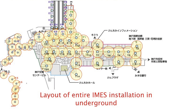
By Dinesh Manandhar and Hideyuki Torimoto, GNSS Technologies, Inc. Japan
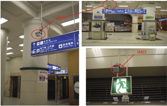
An indoor messaging system (IMES) has been developed to meet the challenges of indoor and deep indoor positioning, as a system that can be implemented in any device that has a GPS/GNSS receiver without hardware modification. IMES can provide reliable 3D position data with a single transmitter device without performing range calculation.
The cost of embedding location data in portable electronic devices is so low that universal penetration can be foreseen in the next five years. Roughly 70 percent of the world’s population now uses approximately five billion cell phones. This number has doubled in the last four years. Future growth is expected at the same or even a higher growth rate.
Due to the emergence of smart phones and location-based services (LBS), mobile phones are used not only for communications but also for many applications related to LBS, entertainment, and games. GPS/GNSS devices are included in mobile phones due to compulsory requirement of E911 and safety-and-rescue services by law in many countries for security and safety.
Access to map data and value-added services using these map data is getting cheaper and eventually will be freely available. Major service providers like Google, Nokia, and Apple already provide access free of cost, and they increasingly focus on location as a core business construct.
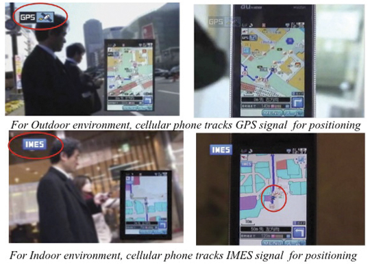
GPS/GNSS devices were designed to work outdoors, and most GNSS applications are limited to outdoor environments. However, GNSS reliability, availability, and accuracy have led to development of many new and innovative applications that are designed for use in both outdoors and indoors in a seamless fashion. Today, GNSS receivers are integrated in many other devices like mobile phones, navigation systems, personal navigation devices, game devices, security devices, and many LBS-related devices. These devices are increasingly used in indoor environments. Indeed, people generally spend much more time indoors than outdoors. Hence, it is extremely important to have a reliable system that can provide fairly accurate position data even in indoor and deep indoor locations.
Current GNSS systems do not provide solutions for indoor and deep indoor environment with reliable accuracy of 10–20 meters. New modernized signals such as L5 do provide better position accuracy and better signal reception in indoor areas, but achievable positioning will still vary, and will continue to require more than four visible satellites with some assist data — and still be limited to soft indoors environments such as rooms with glass windows or walls. Limitations remain for hard and deep indoor environments.
To surmount these obstacles and provide indoor navigation, various technologies such as pseudolites, assisted GPS, wireless networks (Wi-Fi), Bluetooth, RF tagging, and so on have been developed. However, these technologies have their own limitations and are not the most suitable tools for seamless positioning and navigation. Except for pseudolite and A-GPS, they are designed for communication, not for positioning or navigation purposes, but are used for navigation purposes since no other suitable technology exist.
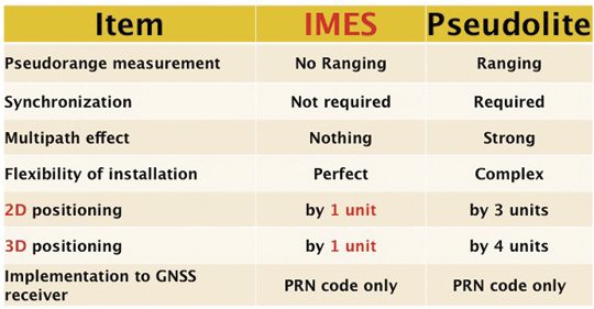
Pseudolite systems are currently in use for indoor positioning. While technically sound, a system needs at least four signal transmitting units. To cover a large area, it needs many transmitters suitably located and time-synchronized to one other, or their clock errors must be known. Pseudolite systems provide position data based on range calculation from the receiver to a number of transmitters, and this calculation is heavily affected by signal multipath. Table 1 compares IMES and pseudolites.
Table 1. Comparison between IMES and pseudolite.
A-GPS is widely used in mobile phones to compute position data. A-GPS technology includes high-sensitivity signal processing to acquire weak signals and external assistance of data like time, approximate position, and satellite-orbit related parameters. Provision of assistance data requires a communication link between the receiver and the data source, for example, the mobile phone network itself. Thus, A-GPS will not be possible if there is no communication link.
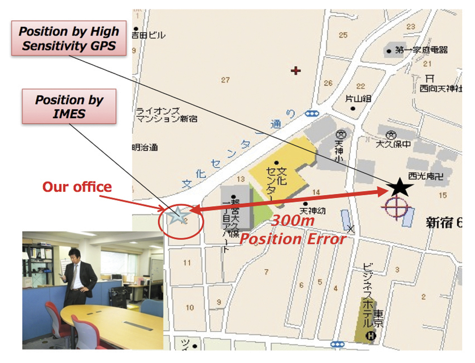
Normally, A-GPS provides 2D position data. The height data (if 3D output is available) will be highly erroneous. The accuracy of such position data varies from few tens of meters to few hundreds of meters. Also, the position data is heavily affected by signal multipath. Figure 2 compares IMES position and mobile phone position inside an office building. The A-GPS position error is about 300 meters in this case.
FIGURE 2. Indoor position from high-sensitivity GPS and IMES.
Wi-Fi is used for indoor positioning in many mobile phone devices. The phone provides position data from a built-in GPS receiver, a Wi-Fi device, cell ID, or a combination of any of these. Recently, position data from Wi-Fi has become popular for indoor as well as outdoor position, since Wi-Fi signals are so freely available. However, using these Wi-Fi signals requires registering the signal power and availability at reference locations. To do this, a huge number of Wi-Fi devices are registered driving around the city. Since these devices are basically installed for communication purposes, they can be relocated, removed, or new devices may be installed without any information to the users or service providers. Thus, continuous maintenance and updating of all these devices are necessary at certain time intervals. The coverage of Wi-Fi devices is not uniform and may vary widely from area to area, affecting position accuracy.
Telecom service providers are considering the possibilities of seamless positioning technologies. They would like to have one single device that can provide 3D position data both indoors and outdoors, without additional power or cost, and with satisfactory 3D position information. If such a seamless positioning technology is available, it will undoubtedly generate a huge global commercial market. The availability of such technology will also aid development of new applications in location-based services, advertising, marketing, entertainment, and gaming.
We have conducted research in indoor positioning for the past few years, beginning with pseudolite systems. We have developed IMES to meet the shortcomings of the technologies described earlier for indoor and deep indoor positioning. IMES for a seamless positioning environment can be implemented in any device that has a GPS/GNSS receiver, without hardware modification. IMES can provide satisfactory and reliable 3D position data with a single transmitter device without performing range calculation.
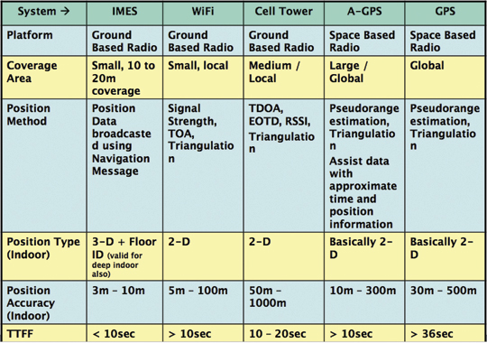
Table 2 compares IMES with other indoor-position capable devices. IMES can provide the same accuracy even in deep indoor locations, whereas cell tower, A-GPS, and GPS cannot work in such areas. All other systems except IMES provide only 2D position data indoors. The height data from A-GPS is very unreliable and hence cannot be used.
Table 2. Comparison of IMES with other indoor positioning systems.
IMES Concept
The main concept of IMES is to transmit position and floor ID of the transmitter with the same RF signal as GPS. IMES transmits latitude, longitude, height, and floor ID by replacing the ephemeris and clock data in the navigation mes
sage of GPS. A single unit of IMES is enough to get the position data, since the position itself is directly transmitted.
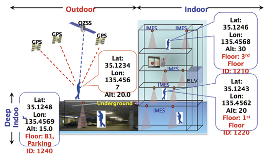
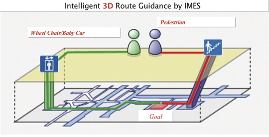
Figure 3 shows the concept of seamless position data using IMES, where the same receiver can be used both indoors and outdoors without interruption. GNSS satellites provide positioning and navigations outdoors, while IMES provides indoor navigation. Since the signal structures of GPS satellites and IMES is the same except for the navigation message contents, the same receiver can be used for both cases. Current GPS receivers will be capable of receiving IMES signals with modification of firmware only to decode the navigation message. Figure 3shows the concept of seamless 3D route guidance.
Figure 3. Seamless 3D route guidance using IMES.
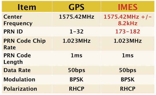
Signal Properties. The IMES signal is designed much like the GPS signal. It uses the same center frequency as GPS with an offset of +/– 8.2 kHz to minimize the possible interference from IMES to GPS signal. Ten PRN codes from 173 to 182 are assigned for IMES. These codes are provided by the U.S. government. Other signal-related parameters are the same as the GPS L1 C/A code signal. Table 3 shows IMES signal properties with respect to the GPS signal.
Table 3. IMES signal properties with respect to GPS.
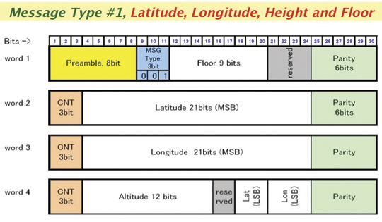
IMES has four different types of navigation message. The most significant is Type 1 as shown in Figure 4. It transmits latitude, longitude, height, and floor ID. The transmission of floor ID is a key factor for perfect 3D position data. Other message types are Type 0 (2-D position data with floor ID), Type 3 (short ID), and Type 4 (medium ID).
Figure 4. IMES Message type 1, 3D position, and floor
Interference Issue
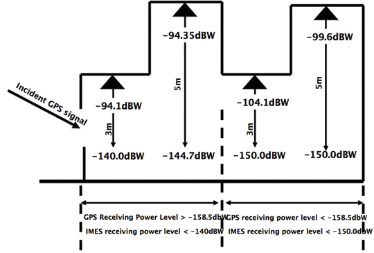
Since IMES shares the same frequency as GPS L1 band (1575.42 MHz), there is an interference level that IMES may have on GPS signals. This interference has been studied in detail by conducting experiments and simulations. Based on these studies and analysis, various methods have been considered to avoid harmful interference to GPS signal. To avoid such interference, IMES center frequency is shifted by +/– 8.2 Khz from GPS L1 band. This will have the least impact on the GPS L1 band signal. For example, if the IMES signal is –110 dBm (very strong) and the GPS signal is –142 dBm (very weak), the loss of GPS signal (C/N0) due to IMES is less than 2 dB. If the IMES signal is –120 dBm and the GPS signal is –142 dBm, there is no loss of GPS signal (C/N0). Based on this analysis, the IMES transmitter power must be controlled such that the maximum power to the receiver does not exceed –110 dBm at a distance of 3 meters from the transmitter. Figure 5 shows the guideline specified in the QZSS IS document for setting the transmitter effective isotropic radiated power (EIRP)based on location.
Figure 5. IMES transmitter power setup guideline in QZSS IS document.
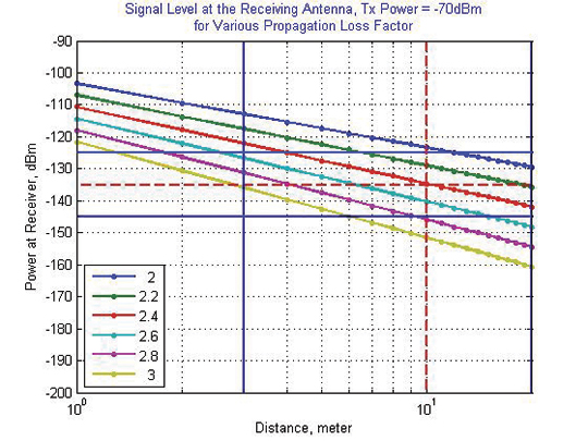
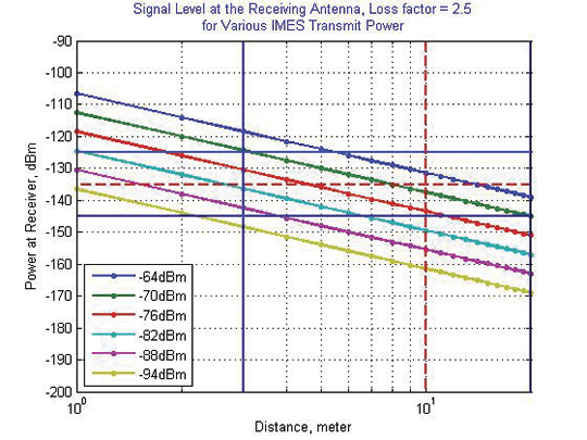
Figure 6 shows the signal propagation loss for transmitter power of –70 dBm for various propagation loss-factor values of n. Figure 7 shows path loss for various transmitter power for the same loss factor, n = 2.5. These graphs shows the maximum power that shall be used to cover an area without exceeding the maximum power level. If a single unit of IMES cannot cover the complete area, then multiple IMES units will be deployed to cover the entire area with suitable power level. These graphs serve as a guideline for setting transmitter power.
Figure 6. Signal path loss for –70 dBm signal for different path loss coefficient, n.Figure 7. Signal path loss for path loss coefficient, n = 2.5, for different transmitter power levels.
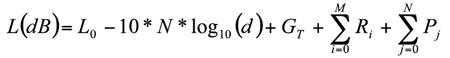
The signal propagation loss is calculated using the following equation; the gain of transmitter and receiver antennas is considered as unit gain (0 dB).
Hence, the equation depends on distance from the transmitter, d, and the propagation loss factor, n. The value of n is 2 for free space and increases for areas with objects that obstruct the signal. An office with soft partitions may use n = 2.5. The graphs can be used as a guideline to estimate the transmitter power to cover an area within the allowed power levels.
Application Areas
IMES can be used wherever indoor position data is required. It depends upon the application for that particular location as well. For example, an infrastructure-related safety application should have IMES installed at all elevators, escalators, staircases, emergency exits and routes, fire-fighting unit locations, and so on. Here are some of places where IMES might be used:
Every room of a building, to provide exact room location.
At entrances, exits, elevators, escalators, staircases, public facilities, and corridors for indoor navigation.
At every emergency exit for guidance.
Along hallways and lobbies at set intervals to guide the user.
In front of shops for advertising and information.
In sign posts to provide user’s location and guidance.
Complement other positioning systems like Wi-Fi, RF Tag, UWB, and so on.
As an indoor ground control point for surveying of large and multi-storey buildings.
With security cameras to provide accurate position data.
In factory production lines for automated control of moving objects.
Business Perspective
IMES technology was developed with the guiding concepts of low-cost global implementation and ease of installation and use. Low cost on the transmitter side is achieved by developing large-scale integratin (LSI) chips and IMES installation, setup, and database management tools. At the receiver side it is achieved by design of IMES signal so that existing GPS receivers in mobile phones, PDAs, or any other devices can use IMES by modifying only the firmware. The signal is designed so that it can adapt to other GNSS signals available in the future, for example, Galileo, QZSS, or Compass signals, requiring only firmware modification. Global implementation is made possible by signal design compatibility with existing GPS or GNSS signals. Ease of use is achieved again by signal design: one IMES transmitter can provide 3D position data, including floor information, with reliability and accuracy of a few meters even in deep indoor locations.
The development of IMES LSI chips (IMES transmitter) will also lead to development of value-added products for many consumer household appliances. For example, the green energy concept produced low-power LED lightbulbs. IMES chips can be installed in LED bulbs at very low additional cost. Similarly, it can be built in many other products like power socket devices, security devices, timing devices, and sensors where position data is also critical. This will provide an opportunity for the manufacturers to provide value-added products to users with indoor positioning devices. Not only electrical products but some construction materials or interior decoration materials like gypsum (dry
wall) boards can be made with built-in IMES chips. Installation of one piece of wallboard with an IMES built-in chip can provide position data in the room, reducing installation cost while not affecting the interior design of the room.
Implementation of IMES will also lead to new applications in the field of location-based services and applications where position data are necessary. It can also lead to new applications using IMES as an indoor electronic ground control point (GCP) in large buildings and indoor areas.
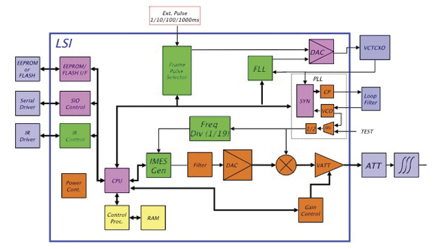
Chip Development. To reduce IMES transmitter cost, the IMES LSI chip has been developed and will be available by the end of the third quarter of 2011. This will reduce overall cost and size, and create platforms to develop value-added products integrating with other devices and systems. The chip is designed for global communications systems like personal handy-phone system (PHS, a mobile phone communication system developed in Japan), CDMA, and GSM. Figure 8 shows a block diagram of the chip transmitter.
The basic specifications of the LSI chip are: size, 12 x 12 millimeters; power, to be determined; maximum transmit power, –30 dBm or –60 dBm (user selectable); frequency, L1 band, 1575.4282 MHz or 1575.4118 MHz (user selectable); PRN codes, 173–182 (user selectable); signal type, GPS L1C/A, with upgrade capability to other GNSS signals.
Installation and Management
An IMES installation, setting, and management system has been developed to facilitate deployment. The main purpose of the system is to provide IMES transmitter position data (latitude, longitude, height) without conducting precision surveys, thus reducing installation, setting, and management costs. The system helps locate optimum locations for IMES transmitter siting, control transmitter EIRP power, set PRN IDs, and assign position data. The system can also use various types of map data sources to generate necessary floor data or indoor maps in 3D. The inputs can be either 3D vector data or 2D raster images, or even paper maps.
The overall system consists of four sub-systems:
IMES Setup Tool (ISET). This tool is used to set up the IMES transmitter. It provides two basic functions: to set up signal-related data (setting PRN code, transmitter power, navigation message rate, and so on) and to set up message-related data (position data, floor data, message types and their contents, message sequence, and so on). The R&D version of IMES also allows transmitting some special data for research and development purpose. It is possible to change the preamble value different from GPS, load a different PRN code table than IMES, change the navigation message data rate, generate a BOC(1,1) signal to test L1C-like signals, and change the RF frequency. The setup tool also has user-access management so that only authorized users can change certain sensitive data like PRN code, position data, and transmitter power.
IMES Database Management Tool (IDBM). This tool simplifies installation and management by providing a necessary database including a building-related database, a service-provider database, a device-related database, other integrated sensors database (if any), and a signal-related database. Since IMES is controlled and managed, guaranteed and authorized services can be provided for dedicated applications. This enhances the reliability of an IMES-based positioning system for infrastructure, security, and safety-related applications.
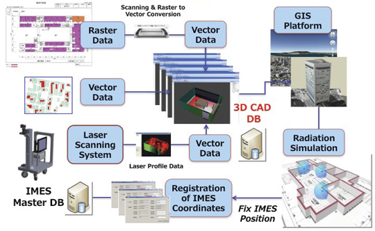
3D Mapping Tool (IMAP). This tool, shown in Figure 9, provides a 3D map database for IMES either for implementation or end-user applications. The mapping tool can use 3D vector data (for example, existing DXF files), raster image data, or direct user input. A laser scanning system with CCD camera is used to generate 3D data if existing data is not available. The tool creates walls, windows, doors, ceilings and other smaller objects from the laser data. If data are available in paper drawings, they are scanned to create raster images before digitizing them into vector format.
Figure 9. 3D Map Database Development System.Figure 10. Concept of IMES database for implementation, setting and management.
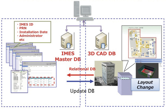
The system will ultimately create a 3D database of a building at floor level that can be linked with external databases. Figure 10 shows the overall concept of the IMES database system that includes both IMES database and 3D map database. The two database systems are linked by a relational database system. Any update in the map database can be reflected into the IMES database.
Signal Propagation Loss Tool (IPMODEL). This tool simulates the signal level where IMES will be set up. It is necessary to have optimum deployment of the transmitter to cover the area as large as possible within the allowed power level. Although the allowed maximum EIRP power level is –64 dBm for Japan, the approach is always to use the least power possible to cover the area, to avoid any possible harmful interference to other systems as well as to limit the availability of the signal to only the desired area.
The following equation is used to calculate the signal path loss which is based on Frii’s free-space path-loss model.
GT is the transmitter antenna gain. The receiver antenna gain is assumed to have unit gain (0 dB) and hence not included in the model.
L0 is the power loss at 1 m distance and is given by 20 x log10(signal wavelength) — 20 x log10(4*pi).
N is the path-loss factor, which is 2 for free space, 2.5 for office room with soft partition, and 3.0 for rooms with hard partition.
Ri is loss due to i number of reflections by objects.
Pj is loss due to j number of penetrations through objects.
Figure 11 shows the propagation-loss tool flowchart. It uses 3D map database provided by the 3D mapping tool and database from the database management tool. It also uses antenna gain pattern and material electrical properties to compute the power loss due to reflection and penetration. Figure 12 shows the signal propagation output from the model for a building lobby. Figure 13 and Figure 14 show the output from the propagation loss results from the actual measurement and model output, respectively. The results match within a difference of few dBs.
Figure 11. Path Loss Tool flowchart.Figure 12. 3D view of signal power in a building lobby.Figure 13. Actual signal power measured at different locations in the lobby shown in Figure 12Figure 14. Signal power output from the propagation loss tool at the same location shown in Figure 13
Experiments and Demonstrations
Experiments and demonstrations have been conducted to validate the IMES concept, uses, and applications. Early experiments validated the
concept, message design, and interference analysis. Later experiments focused on actual implementation for infrastructure, and social-network and location-based applications. Pilot projects have been conducted in collaboration with the Japanese government to test IMES capabilities for seamless positioning and navigation and for social infrastructure platform.
The Free Mobility Project in Kobe is the biggest social experiment using IMES for seamless navigation under the sponsorship by the Ministry of Land, Infrastructure, Transport, and Tourism. The project was conducted in an underground shopping mall of Kobe railway station. Shopping mall visitors were asked to participate in the navigation using IMES-capable mobile phones. Most visitors could follow the route they had chosen or find the destination point using the IMES set-up.
A total of 70 IMES transmitter units were installed at locations including ticket counters, elevator entrances, emergency exits, fire-extinguisher locations, staircases, station entrances, and alleys of the shopping mall. Figure 15 shows a part of the IMES transmitter location map. It covers one of the sections of the shopping mall. Figure 16 shows various locations where IMES transmitter devices were installed. As shown in Figure 17, intelligent 3D route guidance can be performed based on user preference. For example, a user in a wheelchair must be guided by a route that has no staircases, shown by green route in the figure, to reach the destination. A pedestrian can be guided by red route, which is the most direct route to the destination.
Figure 15. IMES transmitter location map to cover the underground shopping mall in Kobe Station.Figure 16. Installation of IMES near the station entrance and emergency exit.Figure 17. Intelligent 3D route guidance using IMES.Figure 18. Seamless navigation by mobile phone using GPS and IMES.
The distribution of each IMES transmitter is done in such a way that it covers a radial distance of 10 to 20 meters. The deployment density of IMES depends on the location environment. If an IMES device is located near the entrance, the coverage distance will be around 10 meters to minimize transmitted power. IMES devices in deep indoor locations can cover a radial distance of about 15 to 20 meters.
Commercially available mobile phones with a firmware update for IMES were used to receive the IMES position data. The phones also included the shopping mall and station map including related databases for various applications.
Conclusions
IMES can provide reliable and guaranteed 3D position accuracy, including floor information. IMES signal design is done in such a way that it can use existing as well future GPS/GNSS receivers without any hardware modifications. Necessary implementation, setup, and management tools are also developed to facilitate IMES installation and to minimize the cost so that large-scale global implementation is possible. IMES LSI chips are being developed for large-scale implementation. IMES will also help in developing many other location-based applications and services. IMES evaluation kits will soon be available for joint R&D projects.
IMES technology-related patents have been filed in Japan and many other countries. The basic patents have already been approved in Japan. GNSS Technologies invites academic institutions to participate in joint R&D projects.
Dinesh Manandhar is a visiting researcher at the University of Tokyo, where he received his Ph. D, and a senior researcher at GNSS Technologies Inc. He is one of the designers of IMES message structure and involved in developing indoor navigation system based on IMES for seamless navigation environment. He can be reached at [email protected].
Hideyuki Torimoto is the president of GNSS Technologies Inc. Japan. He established Trimble Navigation Japan and Weathernews Inc. in 1986. He also established the Research Forum on Social Infrastructure for Advanced Positioning (NPO) in 2003 and the Satellite Technology Laboratory in Tokyo University of Marine Science in 2004. He served as Satellite Division Member of ION for 2003-04. He can be reached at torimoto @ gnss.co.jp.
It’s coming. Indoor location, which has been stymied by the limitations of GPS and lack of mapping, is finally getting some legs and is heading us towards seamless navigation. A shopper is guided from home to an empty parking space at the mall, and the navigation doesn’t miss a beat as he heads inside and gets directions to a particular store, and perhaps to a given shelf. Today, the location of a wireless device usually cannot be determined more precisely than the building it is within. In tall or sprawling venues like arenas, malls, dormitories, or apartments this is a critical problem for emergency personnel trying to locate a person who has dialed 911. Mobile marketing and social network applications have also been constrained by problems in obtaining indoor location.
Finding Cherries. Aisle 411 is a shopping app with local search and navigation that helps users find a particular item within a store. The app navigates to the threshold of a store and then provides a diagram of the interior (essentially a paper map) with a drawn path to the desired item, for instance, a jar of maraschino cherries. Apps like this provide a good service, but are held back by the nascent state of indoor navigation. Geo-coded locations of indoor stores often aren’t available. Apps that are more granular and attempt to locate goods within a store face greater challengers. Inventory is moved around and geo-coding is infrequent, hence the diagrams of Aisle 411. Some applications like Aisle 411 utilize crowd-sourced maps, in addition to venue-provided maps.
Height Counts. Products are being introduced to determine the elusive “z” plane, or in layman’s terms, height. Location systems work well at determining the “x” and “y” axis but can’t distinguish between a location on the first floor and one on the twentieth floor. Polaris is releasing an indoor location offering in the second half of this year. In addition to Polaris’ existing location technology, the solution also uses femtocell and distributed antennas without necessitating a client on the handset. Polaris can distinguish a position within a range of five floors. Infrastructure provider CommScope introduced GeoLENS Indoor, a solution that integrates with wireless indoor coverage systems including distributed antenna systems (DAS), repeaters, and other RF equipment.
Inside Job. Micello, a small start-up, has been addressing the indoor mapping issue. The free Micello app contains the maps of the insides of large structures including shopping malls, airports, hospitals, and business campuses. So far, Micello has mapped 215,545 structures in 2,200 locations.
3D Indoors. Navteq showed off Destination Maps’ indoor navigation system at the International CTIA Wireless 2011 show, held in Orlando March 22-24 . The maps are available in 200 U.S. shopping malls and provide detailed 3D guidance and information within indoor structures. The system will use transmitters within buildings that communicate via Bluetooth and Wi-Fi.
Monster in the Room. Mobile users aren’t satisfied by industry privacy measures. “About half the people in a study of 1,500 consumers we interviewed are concerned about who knows their location, particularly businesses,” says Kristi Crum of Verizon. Subscribers want to understand how their data is being used, whether is it being aggregated, or if it is being shared personally or kept totally private. It will only take one or two high-profile events involving misuse of data before there is fallout on our industry, warns Crum.
Monetize, Monetize, Monetize. Mobile payment systems will become ubiquitous. Google is collaborating with MasterCard and Citigroup to embed contactless near-field communication (NFC) payment technologies in Android. Financial service companies are becoming players in mobile advertising and will likely provide advertising networks like Google with consumer data that will enable more targeted advertising. Google is starting a pilot in New York and San Francisco and is paying for thousands of point-of-sales readers for stores in the regions. Google will go head-to-head against ISIS, a nationwide mobile commerce NFC venture that includes Verizon, AT&T, and T-Mobile. ISIS plans to introduce services within the next 18 months.
GPS Interference Concerns Grow. The Department of Defense and the Department of Transportation have added their voices to concerns over LightSquared’s hybrid satellite-terrestrial LTE network, which they think may interfere with GPS systems. In a letter to FCC Chairman Julius Genachowski, the agencies state they were “not sufficiently included” in the development of LightSquared’s initial work plan to address potential GPS interference issues caused by its network. An FCC spokesman tried to ease concerns by indicating that LightSquared will not be permitted to go forward until potential GPS interference issues are addressed.
At CTIA, LightSquared acted as though there were no hurdles in its way. CEO Sanjiv Ahuja asserted that the company will beat its build-out goals with a commitment to cover 100 million POPs by the end of 2012, 145 million by the end of 2013, and 260 million by the end of 2015. “We are not only committed to meeting these milestones, we are today positioned to exceed them,” Ahuja said.
DoCoMo. There was a large empty space where Japan’s NTT DoCoMo’s CTIA booth would have stood. DoCoMo issued a statement that it was skipping CTIA to focus fully on delivery of mobile services for relief efforts. In the bare exhibit space, a solitary vase stood filled with cherry blossoms.
Now that CTIA is over, and without a lot of location-based services news at the Orlando show, the time is ripe to examine the potential blockbuster AT&T acquisition of T-Mobile and how it affects the location industry. In the meantime, is Apple trying to get its mapping initiatives stronger to compete with other heavyweights? Does this include trying to be its own map database provider?
The potential blockbuster acquisition of T-Mobile by AT&T raises some eyebrows in the location industry, not because of the consolidation of two major wireless carriers with navigation programs, but for spectrum availability issues. At least one analyst believes so.
“I think AT&T has been very open in indicating that one of the major reasons for the acquisition of T-Mobile was a response to the spectrum crunch,” said Michael Dobson, TeleMapics president. “According to Ralph de la Vega, president and CEO of AT&T Mobility, their customers’ data usage has grown 8,000 percent over the last four years and is predicted to grow 8 to 10 times larger over the next five years. During the CEO Roundtable at CTIA, de la Vega indicated that the proposed deal will help to alleviate the spectrum crunch that both AT&T and T-Mobile are experiencing in key markets by allowing them to more efficiently use the allocated spectrum. I should note that details on how the spectrum would be used more efficiently as a result of the potential acquisition were not addressed at CTIA.”
Dobson said Robert Roche of CTIA’s comment were illuminating. Roche indicated that data usage in 2010 grew by 110 percent compared to 2009 and totaled 388 billion megabytes of data. Note that this “data” total does not include the more than two trillion minutes of air-time generated by wireless users or the 2 trillion text messages sent by them during the same period, Dobson said.
“In 2010 data accounted for approximately $50 billion of the total $160 billion, or services revenues realized by the wireless carriers. In 2000, data revenues for carriers were $211 million out of $55 billion in wireless service revenues,” he said. “In essence, data revenues have increased from less than one-percent of the revenue pie to almost one-third of present revenues over the last 10 years.”
While it is impossible to ferret out the size of the data usage total that could be attributed to location services, Dobson says there is little reason to assume that it does not mirror the trend in data growth in general. “If AT&T can advantage itself by easing its spectrum crunch through the acquisition of T-Mobile, it could result in the company being more interested in navigation and LBS than in the past, especially if the action takes the heat off of them in the cellular call performance horse race with Verizon — for instance, fewer dropped calls,” he said.
As an interesting side note, CTIA’s Roche indicated that texting has grown from an average of 14 million messages a month in 2000 to 187.7 billion messages during the 31 days of December 2010, Dobson said. “How many of these were related, in some manner, to location services or casual navigation — not a formal navigation service — remains unclear, but it is likely that many of these messages are about the user, where the user is, and where you can meet them,” he said. “Location and navigation are at the core of many social interactions, but finding the business strategy to unearth the value remains the problem for both the industry and the carriers.”
Is Apple Trying to Improve Mapping?
According to a number of recently published reports, Apple is starting to recognize that Google may have its stuff together on mapping technology and use. Recently, Apple had a job opening for an iOS Maps application developer — with rumors that it plans to redesign the iOS application — and even create its own maps database.
“It is always difficult to know what Apple’s corporate strategy is in any area, much less one, like mapping, that is not in the limelight. While it is quite apparent that Apple will make some strategic move in mapping/location services, the nature of the strategy will likely be determined by Apple’s goals for its nascent advertising business aimed at mobile handsets,” Dobson said. “Those who use an iPhone have probably used the resident map app that is linked with a contact list. While the map data is provided by Google, the rest of the application was designed and developed by Apple. Clearly, they have experience in working with location data, as well as having augmented these skills through two modest acquisitions of companies who knew how to ‘munge’ data.”
Dobson suspects that Apple will come out with some enhanced location software, featuring its usual slick interface and well-thought-out application. “However, the interesting question for the industry is whether or not Apple needs to be a map database provider in order to differentiate itself and its phones from the competition,” he said. “Android (Google) phones are powered by Google Maps, Nokia phones by Ovi Maps, and Windows phones by Bing Maps and soon by OVI Maps (Nokia) — although each of these is merely an instance of Navteq, which is, of course, owned by Nokia.”
Dobson isn’t sure whether Apple needs to be a map supplier to be successful in the mobile advertising business. He said that the question, however, is whether or not Apple would be comfortable having a potentially substantial revenue streams dependent on the good will of a “foreign,” and possibly antagonistic, map supplier who is also a mobile competitor, or owned by one.
“On the other hand, Apple is always upsetting the applecart. For example, I understand that one of the major traffic providers in the U.S. is developing a street-level database for the country’s top 20 urban areas,” he said. “When I first heard about this, it did not make much sense to me, since it is difficult to get into the navigation business with a piece of data here and a piece of data there. However, when I thought of this development as a strategy supporting an advertising play, it became a little more sensible. Unfortunately, there is no way of knowing what Apple intends until someone spills the beans, but it sure is fun speculating.”
Is CTIA Becoming a Throw-away Show?
Some industry observers have noticed the lack of real news at the CTIA conferences…and Dobson is one of those folks. “I have become disenchanted with CTIA and consider the show a throw-away. Anything interesting at CTIA must occur behind closed doors, because it certainly does not appear on the stage or on the exhibit floor,” he said. “On the other hand, perhaps I am too harsh; after all, these folks want to sell services and hardware and are not particularly interested in the details, as long as whatever it is, is hot,” he said. “My disdain for the lack of inquisitiveness at CTIA was sparked by a former Verizon President Denny Strigl, who has written a book about how to be a good manager.”
At the conference Strigl said a manager needs to focus on four things — and only four things — to be successful as a manager. His recommendations: 1) grow your revenues, 2) add new customers, 3) retain old customers, and 4) cut costs. I realize that Mr. Strigl was generalizing, but it often seems that the CTIA audience sees data as a product to sell, but does not have a clear idea about the companies that provide quality data and the markets they serve, especially the location and navigation markets.
“Please note that this is not sour grapes. Apparently unlike Mr. Strigl, I think that innovation in product development needs to be near the top of a manager’s to-do list. However,
the innovation at CTIA seems to have come from Apple, Google, and others who decided how to take advantage of this weakness in the carriers’ philosophy,” Dobson said.
In other LBS news:
I will be reporting at the O’Reilly Where 2.0 conference in Santa Clara, California, this month. If there are location topics you think I should know about and cover, please send me an e-mail.
 This column rarely covers privacy as a critical issue to build location-based services markets. Why? It was our contention that most LBS are opt-in — or opt out — at the discretion of the consumer, making privacy an important issue, but not a market stopper. Frankly, many privacy panels at location conferences either bordered on hysteria, or were not relevant to market growth. However, since the recent Where 2.0 conference, which revealed that some entities were storing location information without users’ permission, the privacy issue has the potential of suppressing products and markets before they even start. Some are dubbing this new privacy concern Locationgate.