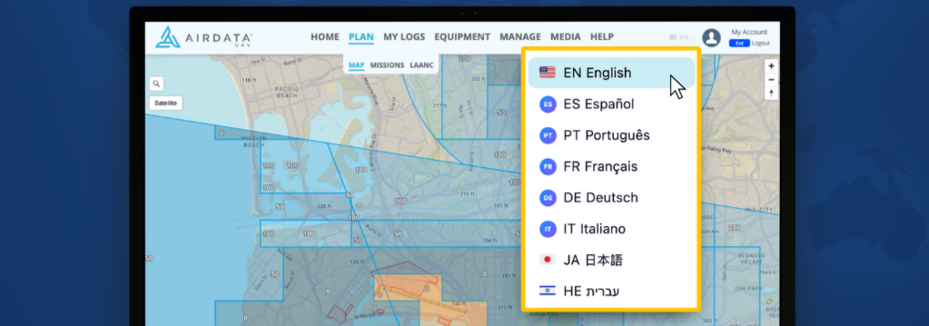
The full platform experience is now available in English, Spanish, Portuguese, French, German, Italian, Japanese and Hebrew.
AirData, a drone fleet data management platform used by organizations worldwide, today announced that its platform is now available in eight languages across both the web application and mobile apps. Supported languages include English, Spanish, Portuguese, French, German, Italian, Japanese and Hebrew.
AirData is used by a wide range of commercial, public safety and government drone programs, helping operators manage daily operations, reporting and compliance across distributed teams. The addition of platform translation reflects efforts to improve accessibility and usability to meet demand from international customers.
AirData automatically displays the platform interface in a supported language, with no manual configuration, plugins or external translation tools required. The default language is determined by the preferred language settings of the user’s device or browser.
The translated interface supports navigation and workflows across daily drone fleet operations and is available across the AirData web application and mobile apps. AirData plans to continue expanding localized support over time, including additional languages, region-specific regulations, compliance requirements, and airspace considerations.
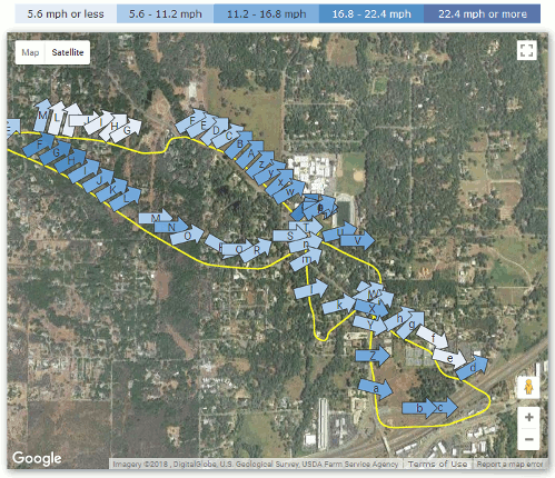
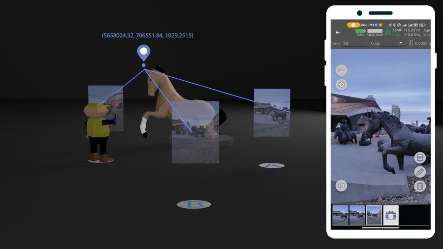
An AirData wind map aids in drone fleet planning. (Image: AirData)
New web tool exports ready-to-deploy XML files, enabling fast and centralized pre-configuration of Eos Tools Pro GNSS settings.
Eos Positioning Systems has released the Eos MDM Configurator, a web‑based tool that allows organizations to quickly create and deploy pre-configured Eos Tools Prosettings across large numbers of mobile devices via their third-party mobile device management (MDM) systems.
Until now, administrators who wanted to deploy Eos Tools Pro through their MDM needed to write an XML configuration file manually — a process that was time consuming and potentially error-prone. The Eos MDM Configurator eliminates manual coding entirely. The tool guides users step‑by‑step through five GNSS categories, supplies a preview of the XML code, and allows the user to export their XML file, compatible with any third‑party MDM solution.
With the Eos MDM Configurator, organizations can centralize control of Eos Tools Pro settings, standardize GNSS data quality, and save time by eliminating manual app configurations.
The five categories that can be pre-configured using the tool include differential corrections, altitude and geoid model, datum shifts, alarms and miscellaneous.
The Eos MDM Configurator is available at no cost to Eos GNSS receiver users. All that’s required to build a configuration is a desktop browser with Internet access. Deploying the resulting XML file requires a third‑party MDM solution, an Eos GNSS receiver (any model), Eos Tools Pro, and at least one mobile device running iOS or Android.
TDK Corporation has announced Trusted Positioning STRIDE, an embedded pedestrian dead-reckoning (PDR) software solution engineered specifically for wearables — smart watches, head-mounted devices, glasses and compact sensors. STRIDE provides reliable positioning without the power and hardware demands traditionally required for GNSS-based tracking.
STRIDE’s low-power, sensor-agnostic software engine fuses inertial data with GNSS and opportunistic wireless signals, delivering continuous location tracking both indoors and outdoors.
STRIDE runs as embedded software, giving OEMs freedom to deploy positioning without redesigning hardware or relying on cloud connectivity, according to the company. STRIDE processes sensor data in real time, ensures low latency, and can be configured for on-device, companion-device, or cloud-assisted architectures. This flexibility helps manufacturers balance performance, power and form-factor constraints based on their device strategies.
Main features and benefits
Low-power on-device mode: Enables continuous PDR in platforms constrained by power, memory or thermal limits.
Geofencing mode: Allows location-based alerts and boundaries for children’s wearables, personnel safety, or activity zones.
Tethering of sensors: Seamlessly uses GNSS and sensors from a companion phone, reducing hardware demand on the wearable.
Off-device processing: Supports computation on a smartphone or in the cloud for advanced analytics or battery saving.
GNSS duty-cycling: Dramatically extends battery life by activating GNSS only when necessary.
Flexible mounting support: Works across watches, smart glasses, helmets, chest-mounted devices and more.
Embedded and real-time: Runs directly on the device with low latency — no dedicated infrastructure, no specialized hardware
Hardware-independent and sensor-agnostic: Integrates easily with a broad range of IMUs and GNSS receivers.
STRIDE is available immediately for trial evaluation, OEM integration, or companion-device implementations.
GNSS corrections company Rx Networks is collaborating with Zephr.xyz, whose software-based positioning SDK enables sub-meter accuracy on Android devices without requiring specialized hardware.
Through this collaboration, Zephr.xyz has integrated Rx Networks’ TruePoint correction services, extending high-precision GNSS capability worldwide with the reliability, availability and continuity required for commercial-scale deployment.
Operating on a global scale, Rx Networks is a provider of GNSS positioning services for tier-1 OEMs, telecom operators, and enterprise customers. Its services are engineered to ensure a five-nines (99.999%) service level agreement for availability, supporting mission-critical and safety-critical applications where continuity, resilience and predictable performance are essential.
Unlike free, experimental or regionally constrained solutions, Rx Networks’ infrastructure is designed for global availability and long-term operational reliability, making it suitable for large-scale commercial deployments.
TruePoint is Rx Networks’ comprehensive high-precision positioning portfolio, designed to support a broad spectrum of customer requirements. Rather than a one-size-fits-all product, TruePoint has solutions that span
global, regional and localized GNSS correction services
accuracy tiers from decimeter-level to centimeter-level performance
multiple deployment models and price-performance options.
TruePoint is designed to evolve alongside customer needs, supporting everything from early-stage experimentation to large-scale production deployments. While Zephr.xyz leverages TruePoint | FOCUS, the collaboration is not limited to a single TruePoint variant, preserving flexibility as applications mature.
Hexagon has joined the Multilateral Memorandum of Understanding (MMoU) on Strengthening the Global Geodesy Supply Chain.
The MMOU is a shared recognition by the United Nations Global Geodetic Centre of Excellence (UN-GGCE) — alongside member state government departments and agencies, private sector companies, organizations, associations, and academic institutions — that action is required to make the foundations of positioning, navigation and timing services robust.
With HxGN SmartNet, Hexagon has built a reliable, scalable GNSS infrastructure that integrates physical reference stations, specialized software such as Leica Spider, and a secure environment for distributing precise positioning data. Supporting tens of thousands of users worldwide, SmartNet delivers the accuracy and continuity essential for daily operations across many sectors.
The MMoU signatories hope to advance resilient positioning services and strengthen geospatial capabilities for nations around the world. Through joint initiatives, they aim to:
Enhance continuity and accuracy of GNSS-based positioning services
Strengthen resilience against signal interference
Support countries in developing and maintaining geodetic infrastructure
Expand education and workforce development in geodesy.
These initiatives ultimately help end users access more consistent accuracy, higher service availability, and stronger resilience against jamming or spoofing.
The MMoU was signed by Henning Sandfort, president, Geosystems Business Area, Hexagon, and Dieter Fritsch, Hexagon’s representative to the UN-GGIM Private Sector Network, on Nov. 17.
“Joining the MMoU underscores our commitment to ensuring that accurate, dependable geospatial information is accessible to governments and organisations worldwide,” Sandfort said.
“Hexagon’s contribution under the MMoU demonstrates the importance of global collaboration between Member States, UN and the geospatial industry,” said Nicholas Brown, head of Office at the UN-GGCE. “Hexagon is a key player of GNSS technology and digital reality solutions and therefore mostly welcomed to contribute the future vision of a strengthened global geodesy supply chain.
Tersus GNSS has launched the MVP S1 RTK-SLAM handheld 3D laser scanner for mobile mapping and reality capture. The MVP S1 uses GNSS through an AI-driven RTK-SLAM workflow, as well as lidar data with imagery from dual 48-megapixel panoramic cameras.
The combination provides survey-grade results in both GNSS-denied and open environments. The system achieves centimeter-level accuracy outdoors and maintains performance indoors or underground through SLAM processing.
TimeSync 3.0 synchronizes the hardware, aligning sensor data at the microsecond level and supporting consistent datasets and reliable post-processing.
A mobile application provides users with real-time feedback, including previews of colorized point clouds while scanning, as well as basic scan reports on site. This feature helps operators verify data completeness and quality before leaving the field, reducing the need for repeat visits.
The MVP S1 supports 3D gaussian splatting (3DGS), enabling creation of textured, photorealistic 3D models. This capability is useful for building information modeling, construction progress monitoring, underground surveys, forestry analysis and industrial site documentation.
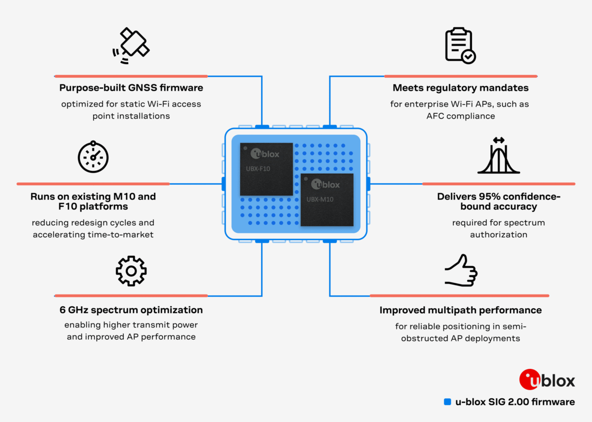
Dedicated firmware delivers AFC-compliant geolocation and adheres to 6 GHz spectrum rules, accelerating deployment of location-enabled Wi-Fi infrastructure.
U-blox has released Standard Infrastructure GNSS (SIG) 2.00, a dedicated GNSS firmware solution for Wi-Fi 6E/7/8 access points operating in the 6 GHz band.
Designed to meet Automated Frequency Coordination (AFC) requirements in the U.S. and Canada, SIG 2.00 enables access points to determine their geolocation with 95% confidence-bound accuracy. It also delivers improved positioning accuracy under multipath environments, ensuring AFC systems receive reliable geolocation data.
Compatible with the u-blox M10 and F10 platforms, the firmware simplifies compliance processes and speeds up integration, helping OEMs deploy high-performance, location-enabled Wi-Fi networks quickly and at scale.
Turnkey geolocation for regulatory-ready 6 GHz deployments
As Wi-Fi infrastructure expands into the 6 GHz band, compliance with regional spectrum regulations becomes essential for Standard Power operation. SIG 2.00 offers a ready-to-integrate GNSS solution that meets these requirements out-of-the-box, reducing design effort while ensuring operational reliability.
Its precise location reporting enables Wi-Fi 6E/7/8 access points to coexist safely with incumbent users of the 6 GHz band, such as microwave and satellite services.
Flexible design options on M10 and F10 platforms
SIG 2.00 runs on two established u-blox GNSS platforms. On u-blox M10, it offers a cost-efficient single-band (L1) ultra-low-power solution for mainstream deployments. On u-blox F10, it provides a dual-band (L1/L5) GNSS with RAW data output, delivering enhanced robustness in multipath or dense environments.
This flexibility allows OEMs to meet a wide range of performance and integration requirements while achieving 95% confidence-bound accuracy and maintaining regulatory compliance.
By removing complexity from AFC compliance, SIG 2.00 supports rapid design-in for enterprise and industrial Wi-Fi deployments, from campuses and stadiums to city-wide infrastructure. With robust positioning accuracy and streamlined integration, it helps accelerate the adoption of high-performance, location-enabled wireless networks in the 6 GHz band.
The 5G PNT network in Santa Clara County will mark the first real-world demonstration of a 5G-powered backup to GPS
NextNav Inc., a leader in next-generation terrestrial positioning, navigation, and timing (PNT) and 3D geolocation solutions, will commence operations of a 5G PNT network in Santa Clara County, California, as early as Dec. 11.
Network operations of positioning, navigation and timing applications represent the next milestone toward commercial readiness and the mission to deliver a resilient complement to GPS.
The 5G PNT network will consist of multiple fixed base station locations using a standards-compliant 5G signal with a positioning reference signal (PRS) enabled, a standalone 5G core, and NextNav’s 3D PNT architecture. The network’s authorized technical parameters will align with those in NextNav’s proposal to optimize the lower 900 MHz band to enable a terrestrial, widescale backup to GPS that is broadly available to critical infrastructure, public safety and American consumers.
“We’re incredibly pleased to continue demonstrating our technology in a real-world operational environment,” said Mariam Sorond, CEO of NextNav. “Activating this network is a critical step in our commercialization process, proving that robust 5G broadband service and high-integrity PNT can be delivered together, at scale, using standard 5G equipment.”
The 5G PNT network will validate NextNav’s 5G PRS-based PNT end-to-end architecture under real-world conditions.
“This is the first public demonstration of a full-scale and operational 5G-based PNT in live deployment, delivering both resilient PNT and broadband service simultaneously,” said Arun Raghupathy, NextNav Co-Founder and CTO. “Through this commercialization deployment, we’re validating our 5G-based network can deliver accurate 3D location, improved timing synchronization, and enhanced resilience. This real-world deployment is critical to establishing U.S. leadership in next-generation PNT technologies.”
The 5G PNT network will support the broader adoption of 5G-based terrestrial PNT with 5G broadband capabilities for operators, enterprises and ecosystem partners. This deployment will also prove that NextNav’s software solution is ready to scale and deliver commercial PNT while serving the critical national security and public safety needs of the United States.
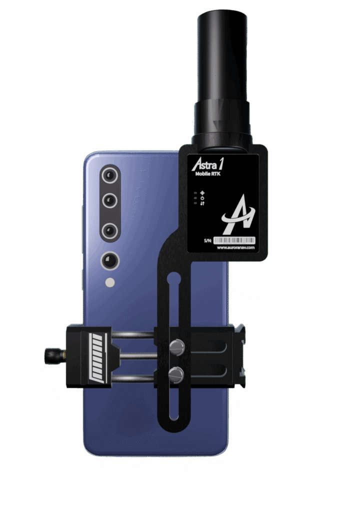
The small, light RTK receiver integrates the Anypos App and LoRa radio for high-precision surveying, photo surveys and 3D modeling.
Image: Aurora Navigation
Aurora Navigation has launched the Astra1 Mobile Visual RTK, a professional-grade GNSS receiver engineered to redefine high-precision mobile data acquisition.
The Astra1 is an ultra-compact (60g) solution designed to deliver reliable, centimeter-level positioning and advanced 3D mapping capabilities through seamless integration with a smartphone and the proprietary Anypos App.
The Astra1 Mobile Visual RTK is built to meet the demand for highly portable, yet exceptionally reliable, high-precision tools that simplify complex field operations.
Full Field Functionality. Users can perform standard surveying tasks, stakeout and RAW data capture directly from their mobile device.
Photo Survey. The system enables high-accuracy measurement of inaccessible or remote points, providing typical accuracy under 4 cm and significantly enhancing operator safety and efficiency.
Georeferenced 3D Scanning. Astra1 allows users to capture photos with precise RTK coordinates, enabling the creation of accurate 3D models for detailed construction verification and digital twinning applications.
Key Functional Features and Reliability:
Unmatched 60 grams and matchbox size
1408 channels, multiple frequencies
900MHz LoRa radio, compatible with Aurora Nav G1000 geodetic receiver
Accuracy: RTK 8mm+1PPM Horizontally, 15mm+1PPM Vertically, Photo survey <4 cm (2-15 m distance)
AI-enhanced reliability
IP67-rated
Mobile Visual Survey Workflow via the Anypos App, transforming a standard smartphone into a comprehensive high-precision data collector.
Image: Aurora Navigation
Industry applications and vision
Astra1 is a suitable and useful tool for professionals across multiple sectors:
Surveying & Engineering. Streamlines field stakeout and topographic data collection with minimal equipment.
UAV & Robotics. Serves as a lightweight PNT solution for GCP collection or base station for unmanned aerial vehicles (UAVs) and robotic platforms.
BIM/Digital Twin. Provides the foundational high-accuracy data required for complex 3D modeling projects.
“We designed Astra1 to address the fundamental need for portability, safety, speed, reliability and simplicity in professional geospatial data collection,” said Zhitao Lyu, founder and CEO, Aurora Navigation. “By focusing on superior performance in tough environments and integrating our Anypos App for a seamless visual workflow, we are delivering a tool that significantly boosts efficiency and safety, and provides survey-grade confidence to every user.”
Headquartered in Calgary, Canada, Aurora Navigation is focused on developing and delivering innovative GNSS solutions. The company is committed to advancing the efficiency and reliability of geospatial data collection through its unique blend of compact hardware design and advanced positioning algorithms.
HERE Technologies has expanded its partnership with Precisely, a data integrity company, to provide accurate and reliable location intelligence for business use cases across industry sectors.
The partnership builds upon location intelligence capabilities within the Precisely Data Integrity Suite, giving companies deeper analysis, validation, and governance of their location data.
Through the partnership, HERE and Precisely use machine learning (ML) and artificial intelligence (AI) to collect and analyze location data, creating real-time updates that guide important business decisions like property management and analysis, among other business operations. The companies are working together to provide complete and accurate datasets to drive AI-powered intelligence for businesses.
The Precisely Data Integrity Suite delivers the trusted location intelligence that organizations need to power critical business decisions. The suite verifies, standardizes, and geocodes address data with high levels of accuracy and enriches it with robust contextual datasets. This combination of accuracy, consistency, and context helps businesses understand where things happen and why, enabling smarter risk assessment, optimized service delivery, and more targeted customer engagement. With governance and transparency built in, the Data Integrity Suite ensures location data is AI-ready and reliable for even the most regulated industries.
HERE’s Privacy Charter reinforces the company’s commitment to promote responsible privacy and security practices, including data minimization and anonymization. The company has a robust portfolio of certifications in security, privacy and cloud governance, including ISO 27001, SOC 2, TISAX, HITRUST r2, CSA STAR and ISO/IEC 42001, the first international standard specifically designed to guide organizations in managing AI systems responsibly.
New solution eliminates positioning errors in logistics, rail, and public safety by providing lane-level accuracy natively on rugged mobile devices.
Swift Navigation, a global leader in precise positioning technology, and RugGear, a manufacturer of rugged mobile devices for professional use, have joined to embed high-accuracy positioning capabilities into RugGear’s enterprise and mission-critical mobile devices.
The partnership integrates Swift Navigation’s Skylark Precise Positioning Service directly into RugGear devices built on the Qualcomm Snapdragon 6 Gen Platform. This native integration delivers reliable lane-level accuracy — an order of magnitude improvement over standard GPS — without requiring any external receiver or configuration. Precise positioning is available out of the box, ensuring seamless performance across rugged mobile form factors.
This integration is a major step in bringing high-accuracy positioning to industrial mobility. All location-based applications benefit automatically, meaning developers do not need to modify their existing apps.
Enhanced Capabilities with the RG940
The first device to integrate Skylark will be the RG940, a high-performance, rugged 10.1-inch tablet designed for demanding industrial uses. The high accuracy improves operational efficiency and accountability across enterprise segments, including:
Logistics and Waste Management. Optimizes routes, reduces fuel costs, and provides indisputable proof of service records for liability claims.
Construction. Provides a value-engineered approach for GIS mapping assets and enhances worker safety through geofenced “no-go” zones.
Rail. Enhances safety and efficiency for trains and prevents freight car loading errors.
Interested customers and partners are invited to contact RugGear directly for availability and technical specifications.
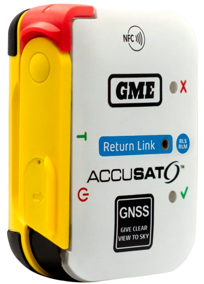
Austtralian company GME is offering its first emergency beacon with Return Link Service (RLS). RLS confirms the distress signal has reached a rescue coordination centre (RCC), providing critical reassurance in an emergency.
The MT620GR personal locator beacon (PLB), with integrated RLS and a mobile app, is a compact safety companion for outdoor and marine adventure enthusiasts.
Enhanced with GNSS for precise global positioning and a 121.5 MHz homing signal, it ensures efficient SAR operations. It is approved for worldwide Cospas-Sarsat operation.
The companion mobile app monitors the beacon’s operational status. With a seven-year battery life and a six-year warranty, it offers dependable performance and peace of mind, according to GME.