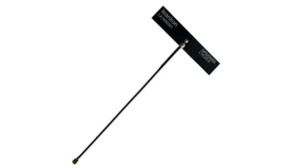
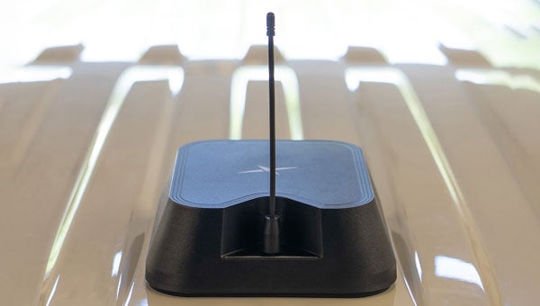
Leankon, a global leader in innovative IoT antenna solutions, has introduced the LK1850301 Dipole FPC (Flexible PCB) GNSS antenna, engineered for seamless integration and high-performance positioning across various applications.
Leveraging innovative technology, the LK1850301 achieves an ultra-compact size of just 49 × 10 × 0.1 mm while supporting global multi-band GNSS. It is fit for GNSS modules and offers flexible cable length configurations to meet diverse design requirements.
Key Features and Benefits
Balanced dipole design: Optimized for superior return loss and stable radiation patterns, the antenna delivers consistent performance while minimizing interference from cable length or connector variations.
Multi-band GNSS support: Supporting GPS L1/L2/L5, Galileo E1/E5, GLONASS L1/L5, and BeiDou B1/B2, this compact antenna is ideal for precision applications such as smart agriculture, industrial tracking, navigation, and asset monitoring.
Customizable integration: Leankon offers multiple cable lengths and connector options, with custom configurations available for seamless system integration and optimized performance.
Designed for compatibility across a wide range of devices, the antenna includes a peel-and-stick adhesive backing for quick, hassle-free assembly.
As industries increasingly adopt global multi-band GNSS navigation, the need for reliable, adaptable antenna solutions is greater than ever. The LK1850301 empowers engineers and product designers with high-performance satellite signal reception in a compact, integration-friendly form factor.
To accelerate project development, Leankon provides free samples of the LK1850301 for early-stage testing and performance validation.
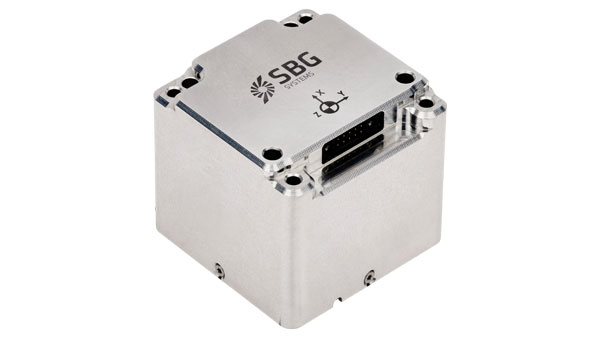
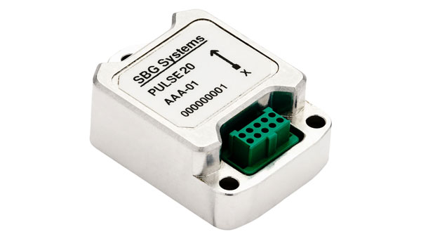
SBG Systems has announced the upcoming release of the Pulse-20 inertial measurement unit (IMU) and the commercial availability of the Pulse-80, expanding its IMU product portfolio to three performance levels.
The Pulse-20, described as a sub-miniature, industrial-grade IMU, will be available before year-end. The company now offers three IMU models designed for different performance requirements: the Pulse-20, Pulse-40 and Pulse-80.
Pulse-20 IMU
The Pulse-20 features built-in magnetometers for nine-degree-of-freedom measurements and includes CAN communication alongside serial connectivity. The compact unit targets applications requiring high performance in limited space.
The Pulse-40 represents tactical-grade performance, while the Pulse-80 delivers what the company calls FOG-level performance without the size, weight and cost associated with traditional fiber-optic gyroscopes.
All three models share the same software interface and undergo temperature calibration and qualification testing, according to the company.
The IMUs target multiple industries including unmanned vehicles, munitions guidance and navigation, electro-optical systems, mobile and surveying applications.
The Pulse-80 is currently available worldwide. The Pulse-20 will become commercially available later this year.
GNSS spoofing has become a regular occurrence with the potential for severe consequences when precise and reliable positioning is critical. Legacy GNSS signals are the primary target for bad actors, as most precise positioning relies on these signals, and it’s constantly getting easier and cheaper for people to fake the message. To combat this, Trimble has introduced Trimble RTX-NMA (Navigation Message Authentication), the first solution on the market to mitigate spoofing attacks on the GPS and BeiDou satellite constellations. Trimble RTX-NMA leverages the Trimble RTX correction service and enhances the security and integrity of GNSS navigation messages for all Trimble ProPoint receivers. Used in conjunction with Galileo OSNMA, users now have three constellations protected from spoofing attacks.
Trimble RTX-NMA seeks to detect both fake GNSS signals and faulty ephemeris data through real-time authentication that ensures navigation messages from multiple RTX reference station receivers are genuine and trustworthy. It also encompasses faulty ephemeris detection, preventing unreliable data from being included in the correction stream. Enhanced security through advanced cryptographic techniques like AES encryption, and stream authentication, take it a step further. Trimble RTX-NMA is also compatible with various Trimble GNSS receivers using firmware version 6.40 or greater, making it a versatile solution for a wide range of applications without a subscription. With these features, Trimble RTX-NMA offers increased reliability, enhanced security, and improved integrity — an added layer of defense against potential threats such as spoofing.
As reliance on GNSS continues to grow, ensuring the security and integrity of navigation data becomes paramount. Trimble RTX-NMA represents a significant step forward in addressing these challenges, offering a robust and effective solution for enhancing GNSS security.
Syntony GNSS, the SDMIS of Lyon and CS-Group have released a demonstration video of the SubWAVE system, filmed at La Mine Bleue near Angers. The video highlights how GNSS signal emulation enables real-time tracking of first responders and victims in GPS-denied environments such as tunnels and mines. This advance allows for precise localization of responders and 112 emergency calls, while significantly enhancing tactical situational awareness during rescue operations.
Emergencies that occur underground — in tunnels, mines, or parking garages — present a critical challenge to first responders: the inability to rely on GNSS signals. Satellite navigation systems cannot penetrate dense materials like concrete or rock, often leaving firefighters and rescue teams without essential positioning data. This lack of visibility can delay victim care and increase risks for responders who are already operating in complex, unfamiliar environments.
The SDMIS of Lyon, noted for its expertise in deep confined-space operations, recognized this operational barrier. In partnership with Syntony GNSS and CS-Group, they produced a demonstration of the SubWAVE system at La Mine Bleue, a tourist site near Angers, aiming to show how real-time GNSS signal emulation can improve safety and efficiency in underground rescue missions.
Central to this development is SubWAVE, a solution created by Syntony GNSS. Unlike GPS repeaters, which only retransmit surface signals underground, SubWAVE generates realistic GNSS signals in real time, including altitude data adapted to different underground layers. These signals are fully compatible with standard GNSS-enabled devices, ranging from professional radios to everyday smartphones. SubWAVE broadcasts these signals through antennas or existing underground radio infrastructure, ensuring a smooth transition between surface and subterranean environments. As a result, responders can be continuously tracked without requiring specialized equipment or recalibration.
The demonstration video clearly illustrates the system’s effectiveness. Firefighters equipped with radios or using the Réseau Radio du Futur (RRF) were tracked in real time, enabling commanding officers to coordinate operations with new levels of reliability.
With GNSS coverage and responder localization now possible underground, a wide range of advancements are within reach. It becomes feasible to locate victims or lone workers, even without active signal transmission, by utilizing GNSS capabilities in mobile phones. Guidance and alert systems can be integrated into helmets or masks for first responders, and artificial intelligence can help map and analyze intervention zones, anticipate hazards, and enhance situational awareness. The technology also allows for interoperability between fire, police and EMS services through shared geolocation data, and may expand precise localization capabilities to complex indoor environments such as shopping malls or high-rise buildings where GPS is often unreliable.
These improvements represent more than mere technical upgrades. They mark a fundamental shift in how emergency services can operate in GNSS-denied zones. By embedding intelligence and connectivity throughout the emergency response chain, SubWAVE aims to redefine standards of safety and coordination in some of the most challenging rescue scenarios.
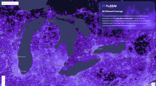
Bluetooth network enables real-time asset tracking for enterprises worldwide
The new Hubble BLE Finding Network is a Bluetooth Low Energy (BLE) finding network built specifically for enterprise use. Hubble, based in Seattle, is a satellite startup enabling Bluetooth devices to connect directly to space.
While consumer platforms like Apple’s Find My and Google’s Find My Device brought BLE discovery to personal devices, Hubble now brings that same reach and simplicity to businesses, offering real-time visibility and full data ownership on a global scale.
“Consumer networks proved what’s possible, but businesses were left out,” said Alex Haro, co-founder of Hubble. “We’re giving them a powerful alternative with global visibility, zero infrastructure and full ownership of their data.”
The Hubble BLE Finding Network leverages nearly 100 million passive scanners across gateways, smartphones and partner infrastructure, powered by low-cost BLE chips already embedded in billions of devices. This extensive network covers homes, cities, transit systems and industrial sites, enabling comprehensive global asset tracking for enterprises.
Key Features
Global Reach: Real-time bluetooth discovery via 88+ million scanners worldwide.
Data Ownership: Maintain full enterprise control with no closed systems or vendor lock-in.
Infrastructure-Free: Activate tracking with existing BLE devices, no hardware required.
Robust Security: Protect data with encryption, rotating IDs, and verified endpoints.
Developer Friendly: Enable seamless integration with open SDKs and APIs.
Enterprise Use Cases
Asset Tracking: Monitor tools, inventory, and equipment globally.
Fleet Management: Track assets in transit, on job sites, or in the field.
Temperature Monitoring: Instantly track temperature with BLE sensor tags.
Workplace Safety: Locate badges and wearables in hazardous environments.
Equipment Sharing: Gain visibility and usage insights across distributed teams.
The Hubble’s BLE Network is now live and available for commercial deployment, including developer tools and onboarding support. To learn more or apply for access, visithttps://hubblenetwork.com.
In March 2024, Hubble made history with its Bluetooth connection to space. With a 96-satellite constellation planned by 2028, the company aims to connect one billion devices worldwide.
One of the most persistent sources of GNSS error — ionospheric delay — has been challenging to correct in real time, especially for mass-market devices. While dual-frequency receivers and commercial correction services can mostly mitigate this issue, they remain too costly and impractical for the billions of smartphones and IoT devices that rely on single-frequency GNSS. Even for dual-frequency systems, the commonly used ionosphere-free linear combination amplifies multipath and receiver errors and reduces data redundancy — yielding only two usable combinations from four original measurements.
This landscape may be shifting with the introduction of GloTEC, a real-time global Total Electron Content (TEC) map from NOAA’s Space Weather Prediction Center (SWPC), released in February 2025. GloTEC assimilates both ground- and space-based observations to provide real-time global ionospheric corrections without relying on error-prone linear combinations.
Unlike coarse models such as the broadcast Klobuchar algorithm or forecast-only products such as the predicted IGS Global Ionosphere Maps, GloTEC updates every 10 minutes using real-time measurements. This high refresh rate establishes a new benchmark for open-access ionospheric nowcasting in GNSS applications.
Originally designed to monitor and mitigate space weather impacts on aviation and communications, GloTEC may also deliver a broader benefit: enabling precise, scalable GNSS corrections for low-cost, single-frequency devices, making high-accuracy positioning more accessible and democratic.
Why Nowcasting Matters for GNSS
The GNSS community has long had to choose between accuracy and latency. Predictive models, such as those from NASA CEDIS or CODETEC, can offer reasonable approximations but may fall short when real-time corrections are required, particularly in the context of navigation, asset tracking or autonomous systems.
Post-processed products (such as rapid/final IGS GIMs) provide excellent fidelity but are typically delayed by hours, days, or even weeks. This makes them useful for research or auditing, but not for real-time navigation needs.
Commercial correction services, such as Trimble RTX and Hexagon’s TerraStar, have filled the gap for high-value applications. These systems interpolate ionospheric corrections in real time, but at a significant cost and they typically require specialized GNSS receivers.
GloTEC bridges this gap by delivering a publicly accessible, high-refresh ionospheric product that can support near real-time corrections. Updated every 10 minutes with a 2.5° latitude and 5° longitude spatial resolution, GloTEC represents a major step forward for public sector GNSS capability, particularly in contexts where accuracy, reliability and scale are all crucial. The data has also been supporting the United States Space Force and is accessible through their Unified Data Library (UDL).
Technical Approach: Adapting GloTEC for Practical Use
While the potential of GloTEC is exciting, turning it into usable corrections for consumer-grade devices isn’t straightforward. TEC maps represent volumetric electron density, while most mass-market GNSS chipsets, especially in smartphones, expect simplified models, such as the eight-parameter Klobuchar model broadcast by GPS satellites. GloTEC is a three-dimensional data assimilation system that uses a Gauss-Markov Kalman Filter to estimate electron density in the ionosphere. It ingests slant TEC measurements from ground-based GNSS receivers and space-based radio occultation data, using the IRI-2016 model as its background state.
To bridge this mismatch, Zephr’s team has been exploring regional fitting techniques, whereby a local subset of GloTEC data is used to generate custom Klobuchar coefficients. These can be transmitted to devices via standardized protocols, such as the LTE Positioning Protocol (LPP), enabling improved ionospheric delay estimation with minimal changes to device-side computation. Even with a regionalized Klobuchar fit and LPP encoding, there is still the problem of accessing the GNSS chip to apply the corrections. To solve this problem, Zephr has created a virtualized positioning engine that takes the raw GNSS measurements from the chip and provides a purely software-based solver. This approach allows the team to implement a variety of more advanced positioning techniques using commodity hardware such as smartphones.
Field Testing: A Quantitative Step Forward
To evaluate the efficacy of GloTEC in improving GNSS accuracy, engineers at Zephr used the virtualized positioning engine to conduct 51 real-world campaigns across various conditions – including urban, suburban, static, walking, and driving – using a Pixel 8 smartphone and an RTK unit for ground truth.
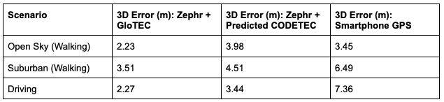
The results were promising, as shown in Figure 1:
Figure 1: GloTEC vs. CODETEC vs. Android Native across multiple scenarios. (All figures provided by author)
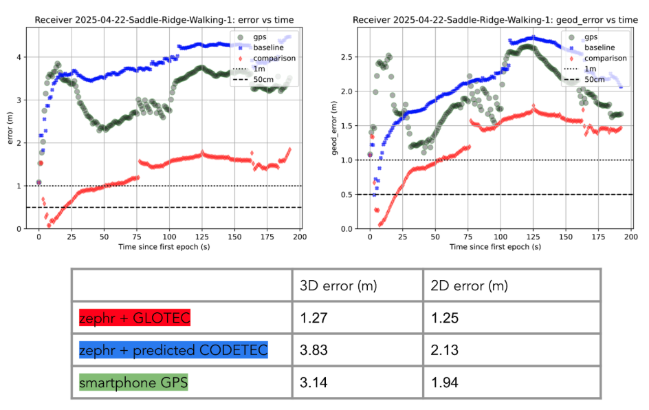
We can break down these results using detailed graphs for each scenario as examples. This will provide a more in-depth look at the positioning for specific traces through the outlined scenarios in Figure 2, Figure 3 and Figure 4:
Figure 2: GloTEC vs. CODETEC vs. Android Native for an open sky walking scenario
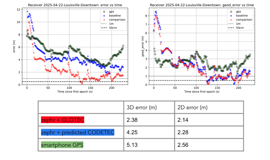
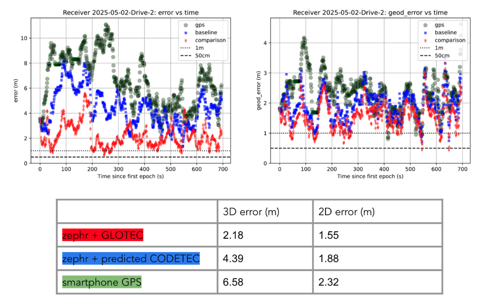
Figure 3: GloTEC vs. CODETEC vs. Android Native for a suburban downtown walking scenario.Figure 4: GloTEC vs. CODETEC vs. Android Native for a mixed sky driving test.
Across all categories, the GloTEC-based regional fitting approach significantly outperformed both the default GNSS solution (which uses broadcast data plus a Klobuchar mode) and the competing IGS products. Accuracy improved by up to 69% in driving scenarios and 46% in walking scenarios, compared to standard smartphone GPS.
While the Pixel 8 used in testing supports dual-frequency GNSS, smartphones face several practical limitations that hinder effective use of ionosphere-free dual-frequency combinations. These include limited signal availability (due to antenna constraints, L1/L5 support gaps, and partial constellation coverage), elevated multipath and noise (especially from omnidirectional antennas in dynamic conditions), and unstable clock biases that complicate error modeling. In fact, iono-free combinations can amplify multipath effects, potentially degrading accuracy in some conditions.
Despite these constraints, the results show that meaningful improvements in positioning are possible using a software-based approach with publicly available corrections. GloTEC, when paired with cooperative or cloud-based GNSS engines, offers a substantial step forward without requiring expensive commercial correction services or specialized hardware.
Broader Implications and Next Steps
While these results are promising, several challenges remain before GloTEC-based corrections can be broadly deployed:
Connectivity Requirements: Real-time access to GloTEC requires periodic downloads over cellular or Wi-Fi connections, raising questions about reliability in low-bandwidth or disconnected environments.
Global Calibration: The accuracy of regional fitting depends on local coverage density and VTEC variability. Further tuning may be needed in equatorial or polar regions, where ionospheric behavior is more volatile.
Nevertheless, the availability of GloTEC marks a significant milestone. For the first time, a free, real-time, high-resolution ionospheric correction product is accessible to developers, researchers, and engineers seeking to improve GNSS accuracy at scale. NOAA SWPC has plans to integrate more low-latency space-based and ground-based data into GloTEC in the near future. The new version of the model outputs will be released to the public once the results are validated. As techniques for applying it to mobile and IoT devices mature, the GNSS community may see a broad shift toward more precise, resilient, and cost-effective positioning systems.
GloTEC may have been designed to help forecasters monitor the response of the ionosphere due to space weather events, but its potential to provide an advanced tool for positioning on Earth is just beginning to be understood. In a world where nearly every mobile application depends on location, and where the cost of poor accuracy is rising (from package delivery failures to navigation errors), this kind of public infrastructure is invaluable.
Researchers and industry developers alike should explore how this NOAA capability can be integrated into their positioning systems. If properly supported, GloTEC could become one of the most impactful GNSS innovations of the decade.
Septentrio, part of Hexagon, has added the onocoy GNSS correction service to its Agnostic Corrections Partner Program. The program is designed to give users the ability to select from multiple high-accuracy correction services, supporting a range of application needs and geographic requirements.
The onocoy service operates as a decentralized, crowdfunded RTK network, providing reliable and cost-effective high-accuracy positioning. This approach is intended to benefit sectors such as agriculture, mining, drone operations, robotics, autonomous vehicles, geodesy and more.
Onocoy operates a community-driven GNSS RTK network powered by Web3 and blockchain technology, to offer secure, transparent and efficient data sharing and transactions, according to the company. Although privately operated, this network actively monitors its base stations to maintain service reliability and quality. Onocoy is joining Septentrio’s Agnostic Corrections Partner Program, which already includes several leading correction services such as GEODNET‘s RTK Service and Swift Navigation’s Skylark Precise Positioning Service.
Taoglas has introduced the Patriot series, a compact, multi-function combination roof mount antenna designed for connected vehicle fleets in emergency services, utilities and commercial sectors. The Patriot integrates up to 18 antenna elements within a single low-profile enclosure, aiming to provide robust multi-network connectivity while reducing vehicle roof clutter and simplifying installation processes
The antenna was originally developed for the Ford Interceptor, allowing for a direct replacement of the vehicle’s OEM antenna. This approach maintains the original antenna’s functionality and adds multi-radio connectivity, eliminating the need for additional holes to be drilled in the vehicle roof. The design is intended to streamline and reduce installation time and costs for upfitters, offering public departments potential savings on antenna-related expenses and removing the requirement to fill in roof holes when vehicles are resold.
The Patriot supports 5G and 4G cellular networks across the 600–6000 MHz range, dual-band GNSS (L1 and L1/L5) with a secondary GNSS (L1), Wi-Fi at 2.4 GHz, 5.8 GHz and 7.1 GHz, SDARS at 2.3 GHz, and LMR/TETRA at 380 MHz to 400 MHz and 700 MHz to 900 MHz. This enables the antenna to deliver concurrent broadband, navigation, telemetry and voice services. A dedicated whip element with full P25 VHF/UHF/700-900 MHz support is available in multiple lengths to meet various frequency requirements.
The platform is flexible and scalable, with the patent-pending design allowing for customization to specific application needs. Full 17- and 18-in-1 configurations are currently available, and additional variants with up to 18 integrated elements are planned based on customer requirements. This modular approach enables organizations to match antenna performance and connectivity with operational needs while maintaining a consistent mechanical design.
The Patriot’s housing is rated IK08 and IP69K for impact and water resistance, measuring 205 mm in length by 180 mm in width, with a variable whip height between 60 mm and 164 mm. The enclosure is designed to fit between vehicle roof ribs and uses the existing OEM mounting hole. A custom-engineered foam gasket ensures a secure and interference-free installation on curved vehicle roofs. The aerodynamic design is intended to enhance vehicle aesthetics and reduce wind resistance, and the antenna is available in black, white and other colors to match vehicle exteriors.
Signal performance is engineered for optimal gain, isolation and efficiency across all supported frequency bands. Cable types, lengths and connector options are customizable to suit specific installation requirements.
Silicon Sensing Systems Ltd and Kongsberg Discovery AS have joined forces to develop next-generation inertial technology. The companies signed the formal agreement June 2 during EXPO in Osaka, Japan.
The agreement will merge the engineering skills of both companies to speed the evolution of products within each company. Kongsberg will use developments to enhance their next generation of high-performance systems – including attitude and heading reference systems (AHRS) and inertial navigation systems (INS). Silicon Sensing will use these outcomes to benefit its precision micro electro-mechanical systems (MEMS) inertial measurement units (IMUs), gyros and accelerometers.
The companies are aiming to achieve navigation-grade performance from a MEMS-based gyro. Navigation-grade refers to a highly accurate and stable gyroscope used in inertial navigation systems (INS) to precisely measure angular velocity and rotational motion.
Gyro sensors measure changes in rotation angle over time, enabling detection of direction, angle, and vibration. They are used in smartphones, game consoles, car navigation systems, industrial equipment and devices requiring vibration detection, camera shake correction and attitude control.
“The diverse range of applications for this technology is expected to grow significantly in the future,” said Anders Rønningen, executive vice president, Kongsberg Discovery. “This agreement will foster growth for both companies, as well as for Norway, Japan and the UK. We have established a strong presence in the maritime market and are now venturing into new markets.”
“For over a year we have been working with Kongsberg Discovery, exploring how best to bring our engineering teams together to move us towards performance goals that will extend the capabilities of our entire product portfolio – bringing real operational benefits across many industrial sectors. This important agreement details how we will achieve those ambitions,” said Satoru Miyamoto, general manager, Silicon Sensing (Japan).
David Somerville, General Manager at Silicon Sensing (UK), concludes, “This endeavor will fast-track development activities in key areas for both companies, bringing critical performance gains for customers in fields as diverse as satellite control, subsea mapping, industrial robotics, aviation and maritime.”
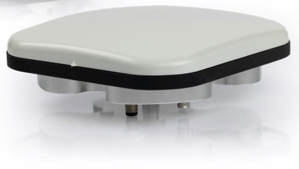
Calian GNSS has released its next-generation anti-jamming controlled reception pattern antenna (CRPA), the CR8894SXF+.
The CR8894SXF+ is an advanced CRPA, engineered to provide efficient interference protection and real-time situational awareness across critical infrastructure, marine, and defense environments where GNSS continuity is mission critical. The CRPA is specifically-designed to provide a low-power and lightweight solution in a compact size.
It features advanced in-band null forming to protect GPS L1/L2 and Galileo E1/E5b signals, helping ensure resilient positioning, navigation and timing in environments with contested, congested or degraded radio frequency conditions. The antenna incorporates Calian’s eXtended Filtering interference mitigation technology to maintain performance and reliability when RF threats are present.
The CRPA supports in-band null-forming of 20 dB to 40 dB and out-of-band rejection up to 80 dB across 700 MHz to 2,500 MHz. It includes two independent low-noise amplifier channels, allowing continued operation if one signal band is compromised.
The antenna forms nulls in both upper (L1/E1) and lower (L2/E5b) GNSS bands to actively suppress jamming sources. A serial output interface provides real-time feedback, enabling users to monitor RF conditions and system status. Outputs include:
CRPA state: open (no jamming), protected (jamming mitigated), or closed (jammed but protected)
Jammer characterization: azimuth and elevation angles of detected interference sources
Summary of threat signals, offering rapid threat assessment for command and control
The CRPA series aims to set a new benchmark in operational resilience, offering advanced protection and intelligence for mission-critical GNSS applications.
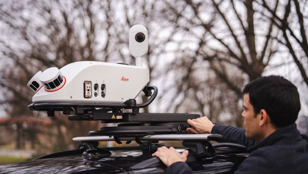
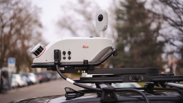
Leica Geosystems, part of Hexagon, has launched the Leica Pegasus TRK300, designed for various mobile mapping applications. As mobile mapping becomes increasingly important for collecting geospatial data, the technology supports smart city projects, infrastructure development and digital twin creation, improving urban planning and operational efficiency across industries.
With this new system, users with varying levels of experience can efficiently capture high-quality point cloud data. “The Pegasus TRK300 opens exciting opportunities for any business looking to enhance and grow their mapping capabilities, from identifying potholes to optimizing city center traffic flows,” says Christian Schäfer, business director mobile mapping at Leica Geosystems. “Because it is lightweight and designed with the user in mind, a single person can easily transport it and mount it to a vehicle, delivering results with minimal effort.”
Photo: Leica Geosystems
The Pegasus TRK300 features a multi-beam scanner system with two scanning heads that quickly collect high-resolution data from multiple angles, minimizing data gaps. With a range of up to 300 meters, the system covers wide corridors and large open areas, reducing the need for multiple passes. This capability allows users to map more ground in less time without sacrificing data quality, resulting in a high-density point cloud suitable for asset mapping and smart city modeling.
The Pegasus TRK300’s robust design allows it to operate in challenging conditions, including heavy rain and dust. Its seven-hour battery life supports a full day of fieldwork without frequent battery changes. The system complements the Pegasus TRK portfolio by offering a portable solution that balances advanced data capture with ease of use.
The Pegasus TRK300 integrates with Leica Pegasus FIELD for data capture and system monitoring and with Leica Pegasus OFFICE for advanced post-processing and final deliverables. This integration seeks to streamline workflows for mapping infrastructure, streets and assets, eliminating complicated file conversions or compatibility issues.
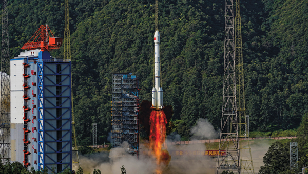
China’s BeiDou satellite navigation system has achieved major breakthroughs and in-depth applications across a wide of range of sectors, according to a white paper issued May 19 and reported by South China Morning Post.
The report was released by the Global Navigation Satellite System (GNSS) and Location Based Services (LBS) Association of China, a semi-official industry body. It reported that BeiDou cemented its leading position in the Chinese market in 2024. , as its economic footprint grew more than 7 percent and it expanded its compatibility to support a broader range of devices.
Key findings from the report:
BeiDou tracks locations more than 1 trillion times every day.
BeiDou drove a total of 575.8 billion yuan (US$79.9 billion) of economic output in 2024, up 7.39 percent year on year.
BeiDou is now compatible with 288 million smartphones, mostly produced by domestic brands like Huawei and Xiaomi.
China’s leading navigation apps – Baidu Maps and Amap – said they used BeiDou to guide users on journeys of a combined 4 billion kilometers per day.
To expand its reach in China’s consumer market, BeiDou is expanding its compatibility from smartphones and in-vehicle satellite navigation systems to wearables, drones, electric bikes and robots.
The China Satellite Navigation Office, aims to replace its existing constellation with new, more advanced satellites by 2035, with the next-gen satellites reportedly supporting real-time positioning accurate to within a centimetre.
The new satellites will provide precision positioning for deep-sea exploration and flights at altitudes far beyond those typically used by commercial aircraft, according to China’s media reports.