Grab Singapore has launched a pilot program that uses high-accuracy lane-level GPS positioning to enhance the navigation experience for its driver and delivery partners in Singapore.
The pilot — rolled out in collaboration with Oppo, Qualcomm Technologies and Swift Navigation — also marks the first deployment of high-accuracy GPS positioning on mobile phones and app integration in Southeast Asia, delivering unprecedented outdoor location accuracy for Grab’s partners.
Grab is a leading app in Southeast Asia, operating across the deliveries, mobility and digital financial services sectors. It enables location-based services in more than 800 cities in eight Southeast Asian countries: Cambodia, Indonesia, Malaysia, Myanmar, the Philippines, Singapore, Thailand and Vietnam.
As part of its ongoing efforts to enhance the GrabMaps navigation experience, Grab continually explores new technologies to help improve accuracy and reliability for its driver and delivery partners. In dense urban environments such as Singapore’s high-rise buildings, multi-level roads, and underground networks can degrade standard GPS accuracy above 20 m, complicating navigation between pick-ups and drop-offs, and reducing ETA accuracy.
By bringing together leading technology partners to create an advanced navigation system, Grab’s driver- and delivery-partners can now pinpoint their location with higher accuracy, improving navigation efficiency in GPS-challenging environments, while enabling smoother pick-ups and reduced cancellations.
The pilot taps on the individual expertise of the following partners:
OPPO, which provides its Find N5 foldable phone with dual-frequency GNSS capable of supporting the latest positioning technology.
Qualcomm Technologies, which activates the Meter-Level Positioning for Mobile featured in the Snapdragon 8 Elite Mobile Platform that powers the OPPO Find N5, enabling real-time GPS correction signals.
Swift Navigation, which provides its cloud-based Skylark Precise Positioning Service that uses advanced atmospheric modeling to correct GPS signal errors and deliver 10x greater positioning accuracy. Skylark is built on top of a network of ground reference stations operated in partnership with network operators around the world, including Singapore Land Authority (SLA). SLA operates the Singapore Satellite Positioning Reference Network (SiReNT) which provides Skylark with accurate GNSS data to enable precise positioning for last mile ride hailing and logistics in Singapore.
Together, these technologies power the pilot, with OPPO’s Find N5 foldable phone, Qualcomm Technologies’s Snapdragon 8 Elite Mobile Platform, and Swift Navigation’s Skylark working in concert to deliver precision navigation experiences.
With results of the pilot, Grab plans to extend the enhanced positioning capability to its proprietary Karta devices in the near future — broadening access to precise navigation technology and ensuring more driver and delivery partners can benefit from it over time.
Quectel Wireless Solutions, a global IoT solutions provider, launched three smart single board computers Tuesday designed to speed product development and reduce costs.
The QSM368Z, QSM560DR and QSM668SR offer developers connectivity, operating system and memory options for various applications, the company said.
“These boards are fully finished hardware that can be easily integrated inside customers’ larger systems across a wide range of IoT use cases,” said Raymond Wang, head of Smart SoC at Quectel Wireless Solutions. “Provided in a ready-to-use, single, low-cost platform, these boards are helping to simplify and accelerate the development process for IoT devices of all types, significantly reducing development time with rapid prototyping and cutting development costs.”
The QSM368Z features the Rockchip RK3568 IoT processor with a quad-core ARM Cortex-A55 CPU, ARM Mali G52 GPU, 8M ISP HDR and 1 TOPS NPU. The board supports Linux and Android operating systems.
The device includes triple-screen concurrent display support, 1,000 Mbps Ethernet and 4K video encoding. Built-in Wi-Fi 5 and Bluetooth 4.2 come standard, with optional support for Quectel LTE Cat 1, LTE Cat 4, Wi-Fi 6 and GNSS modules.
The QSM368Z measures 120mm x 100mm x 22.25mm, weighs about 90 g and operates in temperatures from -10 C to +75 C. Applications include IoT gateways, smart displays, industrial terminals, safety monitoring systems, NAS, NVR/DVR and automotive NVR solutions.
The QSM560DR features 12 TOPS NPU and supports Ubuntu, Android and Windows. The platform’s multi-mode 5G capability supports both NSA and SA networks, with 3G and 4G fallback. Wi-Fi 6E with DBS and 2×2 MU-MIMO technologies enable faster data transmission.
The device supports downlink speeds up to 2.5 Gbps on 5G NSA. It measures 120.5mm x 106mm x 22.5mm, weighs approximately 120 g and operates from -35 C to +75 C. Target markets include smart manufacturing, retail analytics, robotics and connected infrastructure.
The QSM668SR supports Android, Linux and Ubuntu and features 1.1 TOPS NPU. The board supports LTE Cat 4, Wi-Fi, Bluetooth and GNSS. Under LTE Cat 4, the board achieves uplink speeds up to 150 Mbps and downlink speeds up to 50 Mbps. Bluetooth 5.0 is included.
Optional GNSS functionality provides positioning through GPS, GLONASS, BDS, Galileo, QZSS and SBAS satellite constellations.
The device includes HDMI, camera inputs, Ethernet, UART, USB, I²C, RS232, RS485, CAN, SD and SIM interfaces. It measures 102mm x 100mm x 23mm, weighs approximately 97.7 grams and operates from -20 C to +75 C. Applications include IoT gateways, smart home systems, industrial control terminals, retail solutions, safety monitoring, vehicle equipment and logistics devices.
Quectel also provides antennas for cellular, Wi-Fi, Bluetooth and GNSS networks, plus custom antenna design and optimization services.
Accurate localization underpins modern mobility, powering everything from precise rideshare pickups and efficient deliveries to augmented reality and autonomous systems. Yet achieving reliable sub-meter precision with commodity hardware remains one of the field’s central challenges.
A range of technologies are being explored to improve positioning, such as real-time kinematic (RTK) and Precise Point Positioning (PPP) corrections, 5G methods standardized under the 3rd Generation Partnership Project (3GPP), simultaneous localization and mapping (SLAM), light detection and ranging (lidar), inertial measurement units (IMUs), and ultra-wideband (UWB). Each plays a role in specific contexts, but for everyday, mass-market deployment, two paradigms dominate the conversation: visual positioning systems (VPS), which rely on cameras and computer vision to match images against reference databases, and GNSS plus inertial measurement unit (GNSS+IMU) sensor fusion, which integrates satellite positioning with inertial data already present in billions of devices.
These two approaches are not mutually exclusive. VPS works best in dense urban areas where GNSS can struggle, while GNSS+IMU excels in the open environments where VPS has fewer features to recognize. In practice, VPS even depends on GNSS to help narrow the search space in its visual database. That makes the two technologies natural complements, and together they provide the building blocks for the next generation of spatial intelligence.
The Role of VPS
VPS use computer vision to determine position relative to known landmarks. In favorable environments – especially dense, feature-rich urban settings — they can deliver impressive accuracy. VPS has been successfully applied in AR anchoring, pedestrian navigation, and even some indoor mapping, offering a level of precision that is difficult to match with GNSS alone.
At the same time, VPS faces challenges that limit its ability to scale as a standalone universal solution. Maintaining vast libraries of reference imagery requires constant collection and refreshing, even for companies with resources such as Google’s Street View. Keeping cameras active and running neural network matching consumes power and compute, with AR and navigation apps often showing rapid battery drain when vision pipelines are engaged.
Performance can also be fragile, with accuracy dropping in low light, bad weather, or environments with limited features such as open fields or glass-heavy corridors where reflections distort recognition. Because VPS requires continuous camera use, it also raises privacy concerns under regulations like GDPR.
But VPS still fills an important feature set: it works best in exactly the environments where GNSS struggles most. In dense urban areas with abundant visual features but heavy multi-path interference, VPS provides a complementary capability that enhances overall localization performance when paired with GNSS+IMU.
GNSS+IMU Fusion
GNSS provides global reach, but smartphone accuracy typically ranges from 3m to 5 m. This may be adequate for turn-by-turn navigation, but it does not meet the precision required for lane-level guidance, pedestrian navigation or building entrances. Pairing GNSS with IMU data changes that equation by adding orientation and motion context.
Sensor fusion combines GNSS position (x, y, z) with IMU-derived orientation (α, β, γ) to deliver six degrees of freedom (6DoF). In practice, this allows devices to determine not only where they are, but also which way they are facing, which is critical for navigation and AR anchoring.
Another key advantage is that fusion also runs efficiently on-device, using low-power sensors already embedded in nearly every phone. It avoids the battery drain and compute overhead of vision-based methods, remains resilient in poor visibility, and largely sidesteps the privacy concerns associated with continuous camera use.
Together, GNSS+IMU and VPS offer complementary strengths: GNSS+IMU provides scalable global coverage, while VPS adds value in dense urban or visually rich environments. Used in tandem, they extend reliable sub-meter localization across a far wider range of real-world scenarios.
Performance in Field Tests
Independent field testing has underscored the impact of GNSS+IMU fusion in real-world conditions. In trials conducted in Louisville, Colorado, standard smartphones relying solely on GNSS averaged ~1.9 meters of error. When collaborative corrections and IMU fusion were added, mean error dropped to ~0.55 meters – a more than threefold improvement.
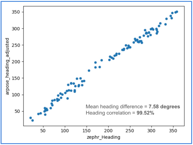
To benchmark localization performance against visual methods, we compared heading determination from Zephr’s sensor-based approach with Google’s VPS, widely considered an industry leader in vision-based localization. Using the same device and location, headings generated from ArPose and Zephr were plotted against VPS outputs.
Figure 1: The figure shows a strong correlation, with a mean heading difference of just 7.58° and a heading correlation of 99.52%.
The results in Figure 1 show a strong correlation, with a mean heading difference of just 7.58 degrees and a heading correlation of 99.52%. This provides a useful benchmark, illustrating that sensor-based approaches can achieve heading accuracy on par with vision-based systems while avoiding the data, compute, and privacy burdens tied to continuous camera use.
Head-to-Head Comparison
When considered side by side, VPS and GNSS+IMU reveal distinct strengths. VPS delivers high accuracy in dense urban environments, where GNSS can be degraded by multipath or blockage. GNSS+IMU, meanwhile, provides consistent global coverage and efficient performance in open environments where VPS has fewer features to recognize. Taken together, they form a complementary toolset, with each addressing the other’s gaps.
Cost & Infrastructure: VPS offers detailed visual positioning but requires continuous investment in capturing and updating reference imagery, which can run into petabytes of data and demand large-scale cloud storage. GNSS+IMU leverages existing satellite constellations and commodity sensors already embedded in smartphones, scaling naturally without additional infrastructure.
Battery & Compute: VPS enables precise landmark recognition but must keep cameras active and process high-resolution frames, a pipeline that consumes energy and compute. GNSS+IMU fuses lightweight sensor readings on-device, sustaining real-time performance with minimal power. Hybrid systems can use VPS selectively for visual anchors when power budgets allow.
Environmental Robustness: VPS excels in dense urban cores where landmarks are abundant, but its performance can degrade in low light, heavy weather, or feature-poor settings such as highways or open fields. GNSS+IMU continues to perform in most outdoor environments, with IMUs bridging short GNSS gaps in tunnels or urban canyons. Together, they extend reliable coverage across diverse conditions.
Privacy: VPS provides visual context but depends on continuous camera feeds, which can raise concerns under regulations like GDPR and CCPA. GNSS+IMU relies solely on inertial and satellite data, which can be anonymized and processed on-device. Privacy-conscious applications may favor GNSS+IMU as the default, while invoking VPS in controlled contexts.
Scalability: VPS delivers strong results in mapped geographies but is constrained by the cost of collecting and maintaining visual data globally. GNSS+IMU scales as more devices ship with standard GNSS receivers and inertial sensors, with accuracy improving further when devices contribute corrections to a shared network. In combination, VPS can add value in high-density urban corridors where visual richness offsets its infrastructure demands.
Beyond Accuracy: Spatial Intelligence Without Cameras
GNSS+IMU fusion not only narrows positioning error but also provides contextual awareness. By combining positional vectors with device orientation, systems can determine not just where a device is, but what lies within its field of view.
This contextual layer enables landmark-aware navigation and natural AI interactions. Instead of vague coordinates, users could be guided to “meet at the blue mailbox next to the coffee shop entrance.” In AR, digital content can be anchored to the physical world without the overhead of vision-based methods. And for AI interfaces, assistants could answer spatial queries (“Is the restaurant to my right or left?”) with precision that feels intuitive.
While GNSS+IMU avoids reliance on cameras, VPS can still add complementary value by providing visual anchors in feature-rich spaces. Used together, the two methods create a more resilient and adaptive localization system, able to support a wider range of real-world scenarios than either could alone.
A Clearer Path Forward
VPS has proven valuable in research, robotics, and AR demonstrations, particularly in dense urban environments. But its reliance on imagery, heavy compute, and continuous camera use makes it difficult to scale as a universal solution for sub-meter accuracy.
To unlock the next generation of spatially intelligent applications, from context-aware assistants to immersive AR, localization must be both practical and massively scalable. This foundation will come from GNSS+IMU sensor fusion, complemented by vision-based methods where they add value. GNSS+IMU builds on infrastructure and sensors already present in billions of devices, delivers efficient on-device performance, and avoids the privacy tradeoffs of camera-based systems.
As positioning becomes the backbone of spatial AI, the evidence points to a decisive outcome: the future will be multimodal, but the scalable backbone will be GNSS+IMU fusion since it empowers devices to understand and interact with the world reliably, with or without cameras.
Trimble has launched its data collector portfolio. The suite includes the Trimble TSC710 data collector, the Trimble TSC510 controller and the Trimble T110 tablet, built for advanced functionality and integration across field operations.
When used with Trimble Connect, a common data environment and collaboration platform, or Trimble WorksManager civil site management cloud software, users can exchange data between the office and jobsite in near real-time to improve operations.
As the physical interface between Trimble hardware and software, the data collectors translate the physical world into an accurate digital representation and back. They enable connected workflows through Trimble Connect and Trimble WorksManager, giving users real-time access to a single source of truth for all project data. Combined with Trimble field software, users can unlock productivity and efficiency gains with quality control capabilities that help reduce project errors and downtime.
The devices are part of an integrated technology ecosystem of Trimble hardware and software, enabling a single source of truth for all project data. The approach enhances collaboration for professionals in surveying and mapping, construction, utilities, mining, oil and gas and public safety and forensics.
“Trimble is dedicated to pushing the boundaries of what’s possible in the field,” said Boris Skopljak, vice president of geospatial at Trimble. “This new data collector portfolio empowers our customers with the tools they need to be productive and stay connected in any environment.”
The portfolio includes:
Trimble TSC710 data collector — Ideal for working with large model data files on a construction site, the TSC710 features a 7-inch touchscreen, a full keyboard and a Qualcomm processor that is faster and uses less battery power than the TSC7. The TSC710 runs on a Google Mobile Services-certified Android 14 operating system. Built for maximizing productivity around connected workflows, the TSC710 is equipped with 5G WWAN support and all-day battery life. The TSC710 has a narrowed neck and is 150 grams lighter than its predecessor.
Trimble TSC510 controller — Engineered to boost field efficiency and optimize workflows, the TSC510 is a robust handheld device with an IP68 rating, compared with IP65 for the TSC5, that enables continuous operation with an all-day battery and a Qualcomm processor up to three times faster than the TSC5, with twice the memory and storage. The TSC510 features a 5-inch screen and runs Android 14. With updated WWAN and Bluetooth modules, teams stay connected for smooth data exchange and real-time project updates.
Trimble T110 tablet — The T110 maximizes field productivity with an Intel 14th-generation Core Ultra 7 processor, built to handle demanding projects and large datasets, including point clouds and imagery. Its rugged design ensures reliable performance in demanding environments. The T110 combines features of the Trimble T10x and Trimble T100 into a single field tablet, including a powerful processor, swappable batteries, 4G LTE WWAN and a Trimble Empower bay enabling communication with Trimble field devices.
Availability
The Trimble data collector portfolio is available now through Trimble’s global network of dealers.
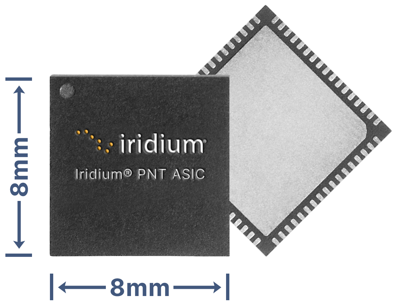
Iridium Communications Inc. has unveiled a dedicated, miniature application-specific integrated circuit (ASIC), the Iridium PNT ASIC. Engineered for seamless integration into a wide range of electronic devices, the Iridium PNT ASIC will deliver authenticated, pole-to-pole positioning, navigation and timing (PNT) data. It will provide a resilient alternative to traditional GNSS, offering protection against spoofing and jamming for consumer, industrial and government applications.
The Iridium PNT ASIC measures 8 x 8 mm and can be fit into devices ranging in size from consumer products to major infrastructure systems like power grids, transportation systems and telecom networks. When embedded in a device, the Iridium PNT ASIC receives a cryptographically secure time and location data signal from the Iridium satellite network that is 1,000 times more powerful than GPS and capable of working inside buildings. This can help GNSS-dependent applications to not only detect a problem but also maintain operations until it is resolved. The Iridium PNT ASIC will also continuously verify signal integrity, making it a suiitable alternative or primary source of PNT data.
Iridium showcased the ASIC’s capabilities during September’s Jammertest, an annual event that evaluates the resilience of GNSS and alternative PNT technologies under jamming and spoofing attacks. The Iridium PNT ASIC maintained both timing accuracy and reliable navigation during controlled exercises.
Iridium is inviting organizations to apply to participate in beta trials, and, if selected, they will receive Iridium PNT ASIC evaluation kits, enabling early integration and testing. The Iridium PNT ASIC is planned for commercial availability in mid-2026.
Iridium Communications is working with T-Mobile to on a broad network deployment of positioning, navigation and timing (PNT) services, starting with live-site activations across the United States. The deployments will deliver 5G network complementary timing synchronization to strengthen the cellular network’s resilience and help ensure reliability for customers.
The U.S. Department of Transportation CPNT Action Plan is designed to evaluate mature and commercially available CPNT technologies to strengthen PNT resilience and enhance the safety of critical infrastructure, like 5G networks. DOT is the U.S. government’s civil lead for PNT.
Under the contract, T-Mobile will expand its installation of Iridium PNT receivers to 90 additional live 5G network sites in geographically diverse locations. Iridium PNT will help protect against GPS disruptions that cause downtime and compromise the data integrity and performance of 5G networks, which rely on coordinated, precise timing to deliver the necessary speed, capacity and reliability of service to end-users.
T-Mobile will also perform nominal and adverse user equipment exercises at its indoor testing range. It has the necessary wireless infrastructure for DOT, Iridium, and T-Mobile to observe and record results.
Capable of sub-100-nanosecond accuracy — better than a millionth of a second — and secured using cryptographic techniques, Iridium PNT signals are 1,000 times stronger than GNSS systems like GPS and work inside buildings with no need for an outdoor antenna. The service is delivered by Iridium’s low-Earth orbit (LEO) satellite constellation, which provides global weather-resilient L-band connectivity.
University of Otago – Ōtākou Whakaihu Waka researchers have developed algorithms that improve the precision of location tracking in smartwatches.
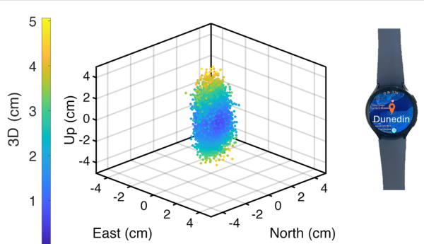
Led by Associate Professor Robert Odolinski, a visiting researcher with Google from Otago’s School of Surveying, the research team demonstrated that a smartwatch determined its location with centimeter-level precision over four hours with a stationary setup. The result was achieved by using the Google GnssLogger app and combining precise signals from several GNSSs.
The research was done in collaboration with Google’s Android Context group and the Chinese Academy of Sciences. Results are published in the scientific journal GPS Solutions.
For decades, achieving centimeter-level positioning has required industries such as surveying, construction and engineering to invest in expensive GPS equipment.
“While the use of the so-called carrier-phase signals has long been known to improve the positioning performance, the specialized antenna and receivers needed for this have traditionally come at a cost far beyond the reach of many who would benefit from the technology. This is just the beginning of what wearable high-precision positioning can potentially achieve.”
GPS was introduced in a wearable watch in 1999, but hardware and power consumption limitations prevented it from tracking the carrier-phase signals needed for high-precision results. Recent advances in smartwatches now make this possible.
Precise centimeter-level positioning on a smartwatch during 4 hours of data in Dunedin, New Zealand. The dots show the repeatability of one second of data in comparison to precise benchmark coordinates. The repeatability of the positioning is about 8 cm, at most twice as large as the smartwatch diameter of 4 cm (displayed to scale).
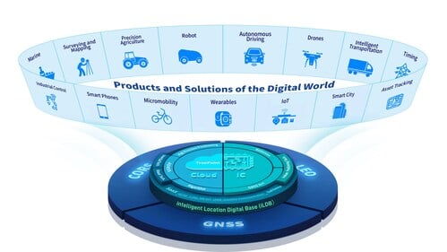
BDStar Navigation Co. Ltd., a provider of positioning technology solutions, has announced its chip-coud integration strategy and introduced intelligent location digital base (iLDB) in Frankfurt, Germany.
iLDB leverages a distributed chip-cloud architecture to create a unified technology and service system. Guided by the chip-cloud Integration paradigm, it combines focused R&D with cross-technology synthesis. This approach delivers robust positioning solutions and powers the integration of physical and virtual environments.
By establishing the iLDB, BDStar has created a closed-loop ecosystem for its positioning products and services, encompassing algorithms, chips/modules, antennas and data services within a unified framework. The company’s solutions deliver on-demand positioning that is all-weather, all-scenario, secure, reliable and intelligently adaptive, serving a wide range of sectors, including intelligent driving, outdoor robotics (such as robotic lawn mowers), unmanned aerial vehicles, and smart wearables across industrial, automotive and consumer markets.
Positioning for Europe. Aligned with the iLDB strategy, BDStar also introduced its new high-precision positioning data service for the European market. Built on network real-time kinematic (NRTK) technology, the service offers broad coverage across Europe and provides customers throughout the region with centimeter-level, real-time positioning accuracy within seconds.
Founded in 2000, BDStar ranks among the world’s top ten suppliers of GNSS core components. In 2025, the company’s global GNSS chip/module shipments are expected to exceed 100 million units. Many leading international brands are already integrating BDStar’s GNSS chips, antennas, and data services into next-generation products designed to address changing market demands.
David Zhou, vice president of BDStar, said the company’s chip-cloud integration strategy delivers multiple benefits through one-stop design, supply and support, enabling reduced cost, enhanced efficiency, assured security, single accountability, and rapid, effective troubleshooting.
Ruxin Zhou, founder and chairman of BDStar, emphasized the company’s global vision. “With our chip-cloud integrated model, BDStar will strengthen worldwide partnerships and continue building a world-class, globally covered iLDB,” he said. “We are committed to creating long-term value for our customers and driving progress in the intelligent era.”
Demand for GNSS chipsets is rising globally, driven by growth in key verticals such as automotive and transportation, consumer electronics, and asset tracking applications. According to global technology intelligence firm ABI Research, global GNSS chipset shipments are projected to grow to 2.4 billion by 2029.
China is expected to lead this growth with the highest Compound Annual Growth Rate (CAGR) of 7.2% between 2024 and 2029, followed closely by Western Europe at 6.7% and the rest of the Asia-Pacific region at 5.6%. In contrast, the Middle East and Africa is anticipated to see slower growth, with a CAGR of 2.7%.
“We are seeing a growing demand for consumer electronics, especially in countries like India, Indonesia, Vietnam and Thailand,” explains Rachel Kong, research analyst at ABI Research. “This is fueled by the rapidly growing middle-class populations and smartphone penetration rates, which are boosting the adoption of GNSS-enabled smartphones, wearables and tablets. In particular, the Sport & Wearables category – which includes devices such as smartwatches, smart glasses, fitness and wellness trackers, and wearable cameras – is forecast to see the highest CAGR of 13.2% between 2024 and 2029.”
Increased E6 band support
Another key technology experiencing rapid growth is GNSS chipsets supporting the E6 band, an emerging GNSS frequency designed for high-precision applications. These chipsets are expected to achieve a strong CAGR of 36.7% between 2024 and 2029, largely driven by high-precision applications such as autonomous driving, aerospace, critical infrastructure monitoring, land surveying, and new location-based services.
With increasing global interoperability and integration of multiple GNSS solutions, worldwide demand for seamless, high-precision navigation continues to rise.
“Manufacturers are more willing to adopt multi-constellation chipsets to support a broader range of applications and geographies,” said Kong.
In addition, vendors such as Quectel, Unicore, Trimble and ComNav Technology are increasingly launching and developing products that support the E6 band. Recent updates, including Trimble’s firmware enabling Galileo High Accuracy Service (HAS) on its devices, and Unicore introducing the UM981 high-precision positioning model, demonstrate the growing traction of this frequency band. Multi-frequency bands are also gaining significance by offering enhanced positioning accuracy, improved signal reliability, and better resistance to interference.
“These bands are already widely used in sectors such as aviation, maritime and automotive, and their adoption will continue to grow as new use applications emerge and evolve over time,” Kong said.
Eos Positioning Systems has announced end-of-life planning for four models in its original Arrow Series GNSS receivers, with discontinuation set for March 31, 2026, or when current inventory is depleted.
The company has began to phase out the Arrow Lite, Arrow 100, Arrow 200 and Arrow Gold receivers on Oct. 2, 2025. The models have been used by mapping professionals and organizations conducting field data collection.
Eos will maintain technical support for the discontinued models for at least five years following the end-of-life date, according to company officials. Support will be available through the company’s technical team and global distributor network.
“These products have served our customers well in a variety of field environments that I could not have imagined in the early days of our company,” said Jean-Yves Lauture, chief technology officer at Eos. “While their time in the spotlight is coming to an end, their impact will continue to resonate.”
The company will continue to offer its Arrow Series plus models, which include the Arrow 100+ and Arrow Gold+ receivers currently in distribution. Eos plans to release two additional models — the Arrow 200+ and Arrow 300+ — though specific release dates were not provided.
Eos is also developing the Skadi Series, described as precision GNSS solutions for professional applications. Additional product specifications and availability information will be announced at a later date.
The original Arrow Series receivers have been part of Eos’ product lineup since the company’s early operations. The devices provided GPS and GNSS positioning capabilities for mobile data collection workflows.
A redesigned software solution embedded with POSPac PP-RTX, Applanix POSPac Complete is available exclusively as an all-in-one term license that bundles essential GNSS augmentation options — single base, Applanix SmartBase post-processed VRS and POSPac PP-RTX service — into a single, transparent annual fee. This eliminates hidden costs, simplifies budgeting and ensures access to software updates, while Trimble RTX removes the need for base stations and provides global coverage.
Because Trimble RTX is embedded into the software, users around the world can attain seamless and efficient workflows with centimeter-level accuracy, even in remote or inaccessible areas, increasing productivity in their mapping process. Additional time savings are gained with the elimination of the time-consuming and challenging task of setting up and managing base stations that may be in different local datums or epochs.
“The new POSPac Complete is more than just a software update; it’s a paradigm shift in how geospatial professionals achieve high-accuracy results because of Trimble’s unique RTX factor,” said Nico Jaeger, product manager at Trimble. “By integrating the power of PP-RTX directly into the software, we’ve eliminated the logistical headaches of base stations and streamlined the entire workflow, making mobile mapping more accessible than ever before. Altogether, it helps new and experienced users to produce survey-grade results with unprecedented speed and simplicity, truly representing the next generation of geospatial processing software.”
Additional features in the new POSPac Complete include:
Modernized user interface: A new look and feel with a background map and a streamlined project wizard for easier and more efficient workflows, and a better user experience.
Trimble IonoGuard: Trimble’s latest technology that detects and mitigates the effects of ionospheric scintillation, which is especially important during the solar activity peaks, supported in single base and PP-RTX processing modes.
Optional add-on features available for purchase:
Camera QC tools: The robust successor to CalQC, providing rapid IMU to camera boresight calibration for single-head and multi-head (oblique) camera constellations with minimal user interaction.
Lidar QC tools: Trimble’s leading software application for IMU to lidar boresight calibration and trajectory adjustment using SLAM techniques is now enhanced with support for automatic ground control point (GCP) detection, the RIEGL lidar native file format and reduced RAM requirements for faster processing.
The POSPac Complete solution will be available in November 2025 through the Trimble sales channels. For more information or to request a demo, click here.
Taoglas has expanded of its Comet Series with the MA58x family of compact, discrete, screw- or through-hole mount puck antennas.
Metal structures or flat surfaces, such as cabinets, can affect antenna performance and change the electrical groundplane. The Comet MA58x series is specifically engineered to maintain stable, high-efficiency operation in these challenging conditions.
Conventional LTE antennas rely on their RF cable to achieve low-band efficiency, particularly when the cable itself is routed inside a metal enclosure, turning it into an unintended radiator. The MA58x design removes this dependency, enabling efficient radiation and delivering at least 20% better performance than comparable alternatives.
With a footprint of 101 x 101 mm and low profile of 20 mm, the antennas deliver reliable multi-antenna connectivity across GNSS constellations including GPS, GLONASS, Galileo, and BeiDou, as well as 5G/4G MIMO and Wi-Fi 6/7. Advanced RF design enables consistent gain and efficiency across global cellular frequencies from 600 MHz to 6 GHz and Wi-Fi bands up to 7.125 GHz, while also supporting legacy 2.4/5.8 GHz Wi-Fi and Bluetooth for maximum compatibility. These levels of performance are rarely achieved in antennas of this size, and even more so when installed on metallic structures.
The rugged, weather-resistant housing is molded in Acrylonitrile Styrene Acrylate (ASA) for long-term outdoor durability, and the IP67-rated enclosure with a screw/stud mount provides a permanent installation option that ensures secure, reliable operation in vibration-prone and harsh conditions such as fleet vehicles, heavy equipment, and industrial automation.
The new antennas are available in multiple configurations and in either black or white enclosures. Custom cable lengths and connector options are also offered, making integration more flexible for OEMs and system designers. The MA58x series is suited to gateways and routers, public safety systems, point-of-sale terminals, digital signage, smart home automation, robotics and industrial automation. The Comet Series also offers a magnetic mount MA32x variant to address different deployment needs.
Further details on the design principles that deliver these performance gains are available in a Taoglas white paper.