This year’s Mobile World Congress, held late last month in Barcelona, featured the world’s largest mobility conference. While there was not a lot of strictly location-based services news, connected vehicles seemed to be the big deal. Ford and GM both made important announcements, sending a signal that wireless information and connectivity is here to stay in a vehicle — and location will be a big part of the growth. On the downside, MWC is becoming a mini Consumer Electronics Show with hotels gouging attendees, long cab lines, heavy traffic, expensive meals and long commutes to the show for those wanting to pay less than $400 a night for a room. Sounds like Las Vegas in January.
By Kevin Dennehy
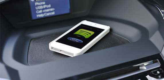
The recent Mobile World Congress, held at Barcelona’s Fira Gran Via conference center, featured big connected vehicle announcements from Ford and GM. Ford announced a slew of deals, one partnering with Spotify to make Spotify Premium available through its Sync AppLink. GM’s big announcement is that its OnStar safety, security and navigation service will use AT&T Mobility’s network for LTE modules in 2014.
Ford’s partnership with Spotify gives drivers access to millions of tunes on the road.
Industry observers believe that GM’s announcement indicates the new AT&T deal could give the connected vehicle market a big boost as the units will go into most cars, including entry-level vehicles. Wireless carriers have indicated that transportation remains one of the key vertical markets they are aggressively getting in to.
AT&T pulled a big coup as GM uses Verizon Wireless for its OnStar service. However, published reports indicate that the company has been disconnecting subscribers who are not currently using the service. Verizon said it had lost 490,000 connections in late 2011 — and said the losses were due to decline in telematics customers.
There is no word on whether 2012’s $617 million purchase of Hughes Telematics had any effect on the Verizon-GM relationship.
Overall, OnStar, which costs $18.95 per month, has more than 6 million customers worldwide.
A concern with connected vehicles, and this is an issue that has been around for the past few years, is that automobile manufacturers do not believe the vehicle isn’t the new mobile phone — though some carriers believe it will be. Another concern is the form factor itself — what is better? What will the winner be? An embedded system or a system that integrates with a user’s smartphone?
Not to be outdone by GM, Ford also said its 2104 Ford Ecosport will feature AppLink capabilities. The company also said it would be offering, in Europe, applications from Kaliki, Glympse and Aha. Ford says it now has 2,500 folks registered in its developer program — doubling the numbers from last month.
Ultimately, many analysts say that two major market issues will need to be resolved for the connected vehicle segment to take off. One is what will consumers want? The other is standardization — will every vehicle have the same system in use? Already Ford and GM seem to have differing technology and business models for this market.
Is Mobile World Congress Getting Too Big to be Useful?
With more than 72,000 attendees this year, which is a little more than half the size of the gigantic Las Vegas-based Consumer Electronics Show, is MWC becoming too big and less focused for wireless application developers, LBS companies looking to partner and other location company entities?
Does this sound like a mini CES? The Fira Grand Via had 1 million square feet of exhibit space, 1,700 exhibitors and 72,000 attendees from 200 countries. All of this is puzzling for a conference that had no Google (the company had a big exhibit last year) or Microsoft.
In addition, there were no huge announcements — even the connected vehicle news would be mid-level news at CES. Does it say something strange about a big wireless show when your main news is connected vehicles?
Deciding not to get lost in the hugeness of a big trade show, most of the wireless companies and handset manufacturers choose to make their own product and deal announcements at their own branded shows or independent press conferences. Outside of a handset having LBS capability rolled out, and companies saying they are rolling out capability in European nations, there wasn’t much location-specific news.
With no big indoor position news at MWC, does that spell a struggle for the new technology and potential gigantic market? Many publications, including this one, has touted indoor positioning as one of the technologies that will spur LBS’ market growth.
A few smaller companies did display indoor positioning products at MWC. Rx Networks rolled out its Xybrid Synchro that allows a device to self-located without an active data network connection. The company also rolled out a cloud-based GNSS systems that allows users to determine a location even when weak location signals are available, the company said.
Another indoor positioning company, Insiteo, showed off its products that work on iOS and Android devices to allow users to find booths at MWC. The company says product finding, location-based marketing and data mining are all applications for the platform.
In other Mobile World Congress news:
Telit launched m2mLOCATE, a feature that adds Cell-ID location for a range of its cellular connectivity modules. The company uses RX Networks’ XYBRID RT service, a database that encompasses 40 million cell-IDs.
CSR demonstrated its Location Services Platform, which features context detection and user self-learning to deliver indoor and outdoor location for the consumer and enterprise markets. The company says the platform has an indoor accuracy of less than 10 meters.
TeleCommunication Systems shopped its LBS suite of services at MWC to both enterprise and consumer companies. TCS recently deployed four new mobile operators on its hosted cloud LBS product. The company says it offers revenue-producing branded and private-labeled applications for navigation, hyper-local search, enterprise and family locators.
ALK Technologies, now owned by Trimble Navigation, said its CoPilot GPS navigation apps for smartphones and tablets will be available for Windows Phone 8 and Windows 8. The company said it’s always been high on Microsoft’s mobile products, as CoPilot was originally developed for Microsoft’s Pocket PC. CoPilot features voice-guided GPS navigation, turn-by-turn guidance, trip planning and automotive-grade street maps, the company said. The unit’s live services include Yelp, ActiveTraffic, Wikipedia and Google Search.
AtlasCT has announced an April release date for the first, full featured, voice-guided turn-by-turn navigation solution for the Firefox OS. The software program will be released under the brand name of “EverNav for Firefox.” This announcement follows Mozilla’s launch of the Firefox OS during the Mobile World Conference in Barcelona in February.
EverNav was initially released on September 2012 as an HTML5 turn-by-turn solution aimed at application developers and mobile marketing campaigns. The solution was quickly adapted by a large number of customers. Now, as part of the preparation for Mozilla’s release of the Firefox OS, a dedicated EverNav version will be released in April.
“We were one of the first few companies to release HTML5 based navigation back in 2012 and we are proud to be the first to release a dedicated navigation solution for the Firefox OS today. HTML5 technology has come to the point that we were able to develop a full-featured navigation user experience, and we are extremely happy with the result,” said Ziv Avni, AtlasCT’s marketing director.
EverNav for Firefox OS will include a personalized navigation experience with features like local information, live traffic reports, favorites and history sections, share location capability, social integration and more.
“As the leading provider of HTML5 turn-by-turn navigation solutions, as soon as we learned about the Firefox OS, we decided to release a dedicated version,” said Shlomo Emanuel, AtlasCT’s CEO. “We are still looking into a number of possible business models for the services and this is one of the subjects we are discussing with mobile carriers that have already committed to backing the open web device initiative.”
EverNav for Firefox OS will be available both on the Firefox Marketplace and on the EverNav website.
The Wall Street Journal is reporting that Apple has acquired indoor-location company WiFiSLAM. Apple reportedly paid about $20 million for the Silicon Valley-based company. Apple has confirmed the purchase to MacRumors, but offered no details on its plans for the acquisition.
Analysts say this is a sign that the war over indoor mobile location services is heating up.
Apple’s acquisition of WiFiSLAM illustrates how 2013 will be a breakout year for indoor location as initial trials shift to technology deployments, application development, and revenues, according to ABI Research.
Two-year-old start-up WiFiSLAM has developed ways for mobile apps to detect a phone user’s location in a building using Wi-Fi signals, according to the Wall Street Journal. It has been offering the technology to application developers for indoor mapping and new types of retail and social networking apps. The company has only a few employees. Co-founders include former Google software engineering intern Joseph Huang.
“The move comes as Apple continues to build its arsenal against Google in mapping,” according to Wall Street Journal blogger Jessica E. Lessin. “It debuted its own mapping service last year to poor reviews and user complaints about inaccurate data. Apple chief executive Tim Cook apologized for the quality of the product, and Apple has continued to improve it.
“Google already offers indoor mapping in certain locations like airports, shopping centers and sports venues,” Lessin said.
ABI Research’s latest report “Indoor Location in Retail: Where Is the Money?” provides an overview of all major technologies, revenue opportunities and competitive environment. “Analyzing across 10 retail sectors, we are seeing a lot of cross pollination as companies combine handset and infrastructure based Wi-Fi, Bluetooth, and sensor location technologies. The emergence of public venue small cells and carrier Wi-Fi will also create a new wave of opportunity,” commented Patrick Connolly, senior analyst. “As a result, we expect to see a flurry of acquisitions and partnerships in 2013, as major players start to make their moves.”
In support of these technologies, ABI Research is also forecasting smartphone retail apps to break 1 billion downloads, while indoor maps will break 1 million buildings, over the forecast period.
Trimble has launched a new mobile mapping product for hunters and anglers. The launch includes two smartphone apps (Trimble GPS Hunt and Trimble GPS Fish), one tablet app (Trimble GPS Maps), and a new Website — GPSHuntFish.com.
The offerings combine the latest in mobile GPS technology and Trimble’s exclusive outdoor maps to help sportsmen plan trips, navigate in remote areas, record GPS information, and privately share details with friends.
“We are excited to launch a comprehensive solution for hunters and anglers,” said Rich Rudow, general manager at Trimble Outdoors. “Now hunters can scout a future hunt at GPSHuntFish.com then send maps and GPS details to their iPhone, Android, or iPad to use in the field. In addition, they can print custom waterproof maps that compliment the digital maps displayed in the mobile apps.”
The launch includes:
Trimble GPS Hunt App
Runs on: iPhone and Android phones
Find hunting spots on detailed outdoor maps, navigate in remote areas and track wildlife. The Trimble GPS Hunt app uses the GPS built into smartphones to track position in the field—even in areas without a cell or data connection. In addition, users can mark waypoints, record tracks, view weather forecasts, see sun and moon phases, and view compass and trip details.
Trimble GPS Fish App
Runs on: iPhone and Android phones
Use Trimble GPS Fish to record fishing trips and keep a report of daily catches. Pinpoint the exact location of each catch, take photos, record GPS tracks, and view detailed street, topo and terrain maps. Use the app to return to previous fishing hotspots. In addition, with an Elite membership, users have access to more than 6,900 lake maps showing 10-foot lake depth contours.
Trimble GPS Maps App
Runs on: iPad
Plan and organize your next hunting trip or fishing trip with the Trimble GPS Maps app. Research hunting lands, find fishing spots and scout access roads on your iPad. This app allows users to fade between street, aerial and topographic maps, and instantly copy-and-paste GPS coordinates onto the digital maps.
GPSHuntFish.com is a portal for all of the Trimble hunting and fishing apps. In addition, users can view and store their trips, view maps in large format, and print maps at home or as a custom print by MyTopo.com. All trips created in the Trimble fishing and hunting apps are stored in the Trip Cloud, an online service that auto-syncs trips between a computer, smartphone and tablet device.
Trimble Elite
Works with Trimble GPS Fish, Trimble GPS Hunt, Trimble GPS Maps, GPSHuntFish.com
Trimble Elite members have access to public land boundaries for 46 states, lake maps for 6,900 lakes, forest road overlays for 134 national forests, real-time weather maps, online trip planning tools and discounts off printed maps. In addition, users can pick from a library of 3,000 Mega Offline Map bundles. These topo map bundles can be downloaded by state, county, or hunt unit and be accessed on the mobile device in remote areas, even with no cell or data connection.
How to Buy. Trimble GPS Hunt and Trimble GPS Fish are available in the Apple App Store and Google Play store. Trimble GPS Maps are available in the Apple App Store. Each app comes in a free or pro version for $4.99. The Elite membership is available for purchase in all the apps and at GPSHuntFish.com for $29.99/year or $2.99/monthly.
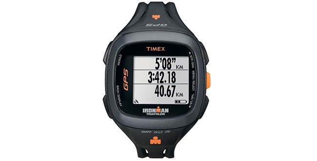
Timex has introduced the Timex IRONMAN Run Trainer 2.0, a next-generation GPS-enabled watch that tracks pace, distance, heart rate, and elapsed time. This upgraded device is a smaller, more refined version of the brand’s signature Timex IRONMAN Run Trainer 1.0 GPS watch and is equipped with a reversible, high-resolution display and advanced interval training capabilities.
The introduction of the Timex IRONMAN Run Trainer 2.0 marks a further expansion of the Timex GPS portfolio, following the recent launches of Timex Marathon GPS, Timex IRONMAN Run Trainer 1.0, Timex Cycle Trainer 2.0 and Timex IRONMAN Global Trainer Bodylink System.
“We heard from the running community that they wanted a smaller, more comfortable GPS watch,” said Sam Martin, Senior Brand Manager, Sports. “We are excited to deliver on that need with the upgraded Run Trainer 2.0, enabling more efficient training through advanced technology.”
The Timex IRONMAN Run Trainer 2.0 is designed for athletes who want to maximize the efficiency of their training. The watch offers a crisp, high-resolution display, but is smaller than the Run Trainer 1.0 to better fit a wider variety of wrist sizes. Armed with a chronograph and featuring hands-free split recording capability, the Run Trainer 2.0 includes Interval Training based on distance and time with vibrating and audible alerts. It has an eight-hour Li-ion battery life and is water resistant up to 50 meters.
Like other Timex downloadable products, this Run Trainer 2.0 is customizable through a computer device agent for all settings and is compatible with TrainingPeaks and MapMyFitness.com, among others. It utilizes ANT+ wireless technology for chest and foot pod sensors to provide heart rate and indoor/cadence-based training data for runners looking to improve their performance.
The Timex IRONMAN Run Trainer 2.0 will be available later this month in U.S. sports specialty retailers and on Timex.com at $224.95 for Speed + Distance or $274.95 (with Flex Tech Digital 2.4 HRM chest sensor).
Verizon is rolling out Networkfleet on the Verizon Wireless network, the company announced today. Networkfleet is a fleet-management solution that provides a wide variety of monitoring and management capabilities for increased productivity and improved customer service.
The Networkfleet solution — part of Hughes Telematics, which Verizon acquired last year — will be combined with the Verizon Wireless network and will debut in Verizon’s U.S. service fleet for improved monitoring, management and route optimization capabilities.
With this all-Verizon solution as part of the company’s telematics portfolio, Verizon is building on its and Hughes Telematics’ joint capabilities to help fleet, operations and risk managers use technology to improve operations by managing speed, fuel consumption, drivers and vehicles while optimizing vehicle use and routes using vehicle diagnostics to help hold the line on maintenance costs.
“As one of the largest commercial fleet operators in the United States, Verizon recognizes the challenges and opportunities associated with managing fleets, and we continue to shape our offerings to help customers turn rolling assets into a competitive business advantage,” said David Small, senior vice president and chief platform officer for Verizon Enterprise Solutions. “We see the fleet management space as a tremendous opportunity. We will continue to work with our ecosystem to serve this growing market, and we are committed to innovating in the machine-to-machine space.”
The Networkfleet telematics solution combines in-vehicle hardware and a web-based application to store, view and analyze data on specific vehicles as well as overall fleet performance. Vehicles are equipped with a GPS device that sends information to the Networkfleet Data Center over a secure wireless network. Key features include GPS fleet tracking, asset tracking, fleet maps, vehicle diagnostics with alerts, roadside assistance, preventative maintenance and other fleet management tools.
Verizon is deploying Networkfleet to an initial 18,000 company vehicles in its fleet this year to expedite customer service, while increasing productivity and cost efficiencies. The initiative will help Verizon achieve its sustainability goal of decreasing its carbon footprint.
The Networkfleet solution can be used in a wide variety of industries including:
transportation
energy and utilities
government
retail and sistribution
construction
insurance
healthcare
media and entertainment.
The Eastern Municipal Water District in Southern California used Networkfleet to lower fuel costs and increase productivity:
The company won one of six categories at the festival’s fifth annual SXSW Accelerator program, which has previously recognized companies such as Twitter and Foursquare. Unlike Google Maps and Apple’s default maps app, which allow people to search for a place on a map and look up directions, Plotter’s mobile maps app offers the ability to plot multiple locations at once. Users can also create maps of their favorite locations and share them with friends.
The app was released earlier this month on the Apple iTunes Store.
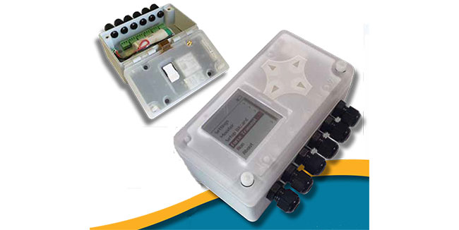
The Metron2 is a multi-function cellular-connected telemetry device capable of making remote fill-level readings in tanks containing liquids and gases. The device’s integral display allows the unit to be used also as a local gauge and for system set up and testing. An optional pulse-counter board allows the device to take external meter readings.
The Metron2 is wide-area-network connected with the Telit GE864-QUAD V2 cellular module and self powered from an internal battery. The Metron2 can be powered from different sources, including an internal battery or an external 6-24Vdc source. It is often not economically feasible to run power to the site for remote telemetry installation, the companies said, such as the cryogenic gas monitoring segment where it is important that the device be on and available to be polled any time, day or night. For this market, Powelectrics developed a solar-powered system.
The solar-powered telemetry system allows the unit to remain always on and connected to the GSM/GPRS network so the server can make contact at any time with instant reading requests. Equipped with the Metron2, a tanker truck can be dispatched to best matching customer locations according to volume available in the tanker and volume required by customers, efficiently exhausting the tanker’s full supply of product instead of transporting it back to base saving fuel and removing the risk of the returned product contaminating the storage or process facility, the companies said.
Knowing how much product is in the customer’s tanks makes it possible to plan when and which truck should make deliveries. This translates into fewer miles driven to deliver the same amount of product and therefore a significant reduction in costs. There is also a dramatic reduction in CO2 emissions. There are also accompanying operational benefits, including fewer emergency shipments, reduced customer service organization and reduced sales resources. These benefits translate into a balance sheet boasting reduced levels of finished goods and raw materials inventory.
The European Chemical Industry Council (CEFIC) has been encouraging more extensive use of Enterprise Resource Planning (ERP) tools to improve supply chain efficiency. According to the Department for Transport in the UK, by 2015, total traffic on the roads will have grown by over 30 per cent compared to 2000 levels and the CBI has estimated that road congestion currently costs the UK up to £20 billion annually.
Telit’s GE864-QUAD V2 ultra-compact, low-power, quad-band GSM/GPRS 3GPP Release 4 module integrated in Powelectrics’ Metron2 has one of the industry’s broadest certification profiles in its class, making it easily deployable anywhere in the global market, Telit said. Modules in this family are capable of data rates of 48Kbps GPRS Class 10 also supporting 9.6Kpbs Circuit Switch Data (CSD) transfers ensuring connectivity in poor coverage areas. The GE864-QUAD V2 family features one of the market’s most compact Ball Grid Array (BGA) package measuring 30 x 30 x 2.8 mm and an extended operating temperature range of -40°C to +85°C, making it suitable for outdoor-environment mobile applications such as the Metron2.
“The last couple of years have seen a dramatic upturn in demand for our product as users of telemetry become comfortable with the reliability and more aware of the benefits that telemetry brings. We continue to develop our already well proven solutions helping drive down the total cost of ownership and therefore reducing the payback time. Telemetry has never been so affordable,” said David Oakes, sales director, Powelectrics. “We realize the need to be flexible in what we offer. Some customers want a complete solution from us encompassing hardware, hosted software and SIM cards whereas others just want the hardware. It’s also vital that data is delivered where it is needed which often means us providing some form of automated interface into the clients systems, delivering data in a customized format.”
CSR plc today announced that its SiRFstarV, SiRFprima and SiRFatlas location platforms are now able to acquire and track satellites and utilize location data from the recently activated BeiDou Satellite Navigation System.
The addition of the BeiDou constellation is part of CSR’s ongoing efforts to support all global navigation satellite systems as they become available, with software or firmware upgrades, for greater performance and enhanced compliance with existing and future requirements of national GNSS systems, the company said.
“CSR is committed to supporting all current and future GNSS constellations with its location platforms to boost location performance by increasing service availability, reducing observation time and making measurements more precise for the most demanding applications,” said Dave Huntingford, director of marketing for location at CSR. “With the addition of these new satellites, our location platforms can now actively utilize GPS, GLONASS, QZSS and SBAS, in addition to BeiDou-2, and they are ready to support Galileo as soon as it becomes available to provide continuous location awareness and the best location-based services experience.”
Rob Yeh, director of product marketing for Automotive SoC at CSR, added, “All CSR’s latest multi-GNSS location platforms, including CSR SiRFatlasVI and SiRFprimaII, are now able to demonstrate live BDS (BeiDou System) navigation, and CSR will include BDS support in all future-generation location platforms. Besides providing flexibility and improved satellite acquisition and location tracking in challenging situations like urban canyons, the BeiDou support also improves CSR’s already industry-leading dead-reckoning technologies.”
CSR maintains an experienced development team in mainland China to develop and support BeiDou-related products and technology.
Also known as Compass and BeiDou-2, the Chinese BDS started operations in December 2012 and has 14 active satellites in service over the Asia-Pacific region available to general users. When fully deployed by 2020, BDS is expected to comprise a total of 35 satellites offering complete coverage around the globe.
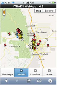
The iTRAK WebApp displays vehicle fleet and landmarks.
iTRAK Corporation, provider of GPS-based tracking, mapping, and reporting solutions, has announced the commercial release of its iTRAK WebApp application. The WebApp provides much of the functionality of the iTRAK Fleet Executive software suite in a mobile environment.
The new application allows iTRAK customers to view all their tracked devices on a wide variety of smartphones and tablets, such as iPhone and Android phones and iPAD tablets. The assets displayed can be tracked using dedicated, in-vehicle GPS devices or GPS-enabled cell phones. Managers and supervisors who regularly work out of the office can still view the location of the vehicles for which they are responsible, as well as historical location and stop data and user-defined landmarks. The mapping system is integrated with Google global street and satellite maps.
iTRAK has been offering mobile fleet management solutions since 2007, when iTRAK FleetFinder, a system to display mobile assets on a Blackberry, was released. The iTRAK WebApp is a response to the convergence of multiple applications on mobile devices, and to customer requests for a mobile fleet management system that will support multiple platforms and operating systems.
The iTRAK WebApp will run on devices that use Apple OS 5.1, 6.0, and 6.1, Android OS 4.0, 4.1, 4.2, and Blackberry 10. Future releases will add geofencing, stored, user-defined map views, and route display. Nine languages are supported: Arabic, Dutch, English, French, German, Italian, Polish, Portuguese and Spanish. There is also an API to the system that allows for third-party integration. Enterprise versions of the cloud services and server software are also available.
iTRAK Corporation (formerly Data Burst Technologies) was founded in 1995 as a developer of GPS-based wireless tracking and AVL systems. The company’s principal offices and network operations center are located in Woodland Park, Colorado.
It’s a streak. The Connected Car was yet again the most exciting emerging technology in the room, this time at the Mobile World Congress (MWC). The connected car service includes navigation, infotainment and location offerings. The big news in this sphere has come from General Motors, but more about that later. Do you remember the death of cellular digital packet data (CDPD)? Now it’s 2G’s turn. The 2G network used by many asset M2M tracking devices is going away. And Amazon is getting in Google’s face with a giant, well-oiled mobile ad network.
Beginning with 2015 car models, AT&T will replace Verizon Wireless as GM’s communications partner. Next year, GM plans to install AT&T LTE modems into many of its vehicles and Verizon will be the network behind GM’s OnStar service. The new modems will enable richer, faster content, including streaming video and radio.
The Connected Car squabbles. Should in-vehicle connectivity be controlled by a smartphone or by an embedded device? There are arguments on both sides. Ford’s forward-thinking connectivity choices have helped elevate what was a dowdy brand. “The last thing we want to do is take this [smartphone] thing that updates every 12-18 months and embed it into a car that has a lifecycle of at least 10 years,” asserted Doug VanDagens of Ford Motor Company. “Users are already paying for the data connection on their phone, and so they shouldn’t be assessed another fee for their car to access a network.” On the flip side, Glenn Lurie of AT&T raised concerns about software updates in a smartphone tethered scenario, in which a user might have to pay for data charges incurred by software updates that auto makers push to vehicles.
Vast market. No matter the approach, the connected car is a huge market opportunity. By 2020, Machina Research predicts that 90 percent of new passenger cars will have some sort of a connectivity platform and the market will reach $600 billion. There are concerns that in-vehicle service offerings may be too complex and could delay uptake. Drivers will want to pay one vendor for in-vehicle services and have pricing and billing options that are not complex.
Prepare for the death of 2G. AT&T plans to shut down its 2G networks by 2017. Verizon is planning to shut down its 2G and 3G EV-DO by 2021. The majority of small enterprises that track assets use 2G GPS modems. Many larger enterprises have been transitioning to 3G (HSPA) in this space. Companies that are considering M2M solutions may want devices that will work long into the future, and as the cutoff date approaches, customers will be increasingly reluctant to make purchases of 2G devices. LTE modems are currently about three times as expensive as 2G modems, which will put a dent in ROI calculations.
Amazon is joining the game. Amazon is rolling out a mobile ad network juggernaut. The mobile ads API, now in beta, enables third-party developers to integrate advertising into Android games and applications. Ad targeting options include GPS coordinates, gender and product floor prices. Android developers have struggled to make money through Google’s own storefront. The Amazon App store for Android has proven lucrative. For every $1 generated by Apple’s App Store for iOS, Amazon generates an average of $.89 per user and Google Play generates just $.23 per user, reports Flurry. Apple has been laying the golden egg, but Amazon knows how to sell and just may surpass Apple.
It’s smartphones. It has finally happened. This year, worldwide shipments of smartphones will squeak by feature phones shipments, predicts analyst firms IHS iSuppli and IDC. Falling smartphone prices and the rise of LTE networks have contributed to the growth in smartphone adoption.
Who were we talking about?Lissted analyzed more than 7,000 tweets about the Mobile World Congress sent by 619 journalists and bloggers and 419 media outlets. Nokia was tweeted about more than any other company, followed by Samsung and Android. Who will lead the hashtag race at CTIA?
A few months ago, many of you may remember that I wrote about an encounter with a rather well-known female journalist who, after listening to one of my GPS presentations, said something like this, “I came here today to learn more about GPS and so far all you have talked about is atomic reference systems…what the heck do those *&@# atomic clocks have to do with GPS…?”
I mentioned at the time how incredulous I was at the question, but that I answered it with a straight face. Now, while professional courtesy prevents me from ever revealing the name of the female journalist, I will say that she evidently started an uncomfortable trend. Much of my correspondence lately has concerned the connections between time and position and/or navigation and why we are so concerned about time.
I won’t bore my more sophisticated readers with GPS 101, or certainly not Time and Frequency Metrology 101, but I will tell you that I think we (this is not the royal “we” but includes all of us who work with and promote GPS on a daily basis) need to do a better job describing just how GPS works and more importantly how critical precise time and frequency is to position and navigation solutions, whether GPS is utilized or not. And I don’t have the time here to take up the argument concerning how important GPS is to our critical national infrastructure. Indeed, a topic and column for another time.
I am sure my time and frequency metrology friends and colleagues at NIST (National Institute of Standards and Technology in Boulder, Colorado) and USNO (U.S. Naval Observatory — read as UTC — home of Coordinated Universal Time and the Master Clock) would probably go about this differently. They tend to approach these problems strictly from a metrology viewpoint. While there is nothing wrong with that perspective, I hope to give you a more hands-on operational view of time and how it relates to position and navigation.
Here are a few quick Smithsonian facts, with commentary added, for those who want to visit and learn just what time has to do with GPS and navigation in general:
What: The Relationship Between Time and Navigation
When: Opens in April 2013.
Where: The Smithsonian’s National Air and Space Museum, Independence Avenue at Sixth Street, S.W., Washington, D.C.
Responsibility: “Time and Navigation — The Untold Story of Getting From Here to There” is being produced jointly by the Smithsonian’s National Air and Space Museum and the National Museum of American History. This is one of the few times, if not the first, that two museums have jointly produced a major exhibit of this importance.
Sponsors: The exhibition is made possible through the generous contributions ofNorthrop Grumman; Exelis Inc.; Honeywell; National Geospatial-Intelligence Agency; U.S. Department of Transportation; Magellan; National Coordination Office for Space-Based Positioning, Navigation and Timing; Rockwell Collins; and ION the Institute of Navigation. Note: The sponsors are listed in order of the amount they gave to present the exhibition, but it should be noted that ION was among the first contributors, making the museums’ decision to go ahead with the exhibit a more comfortable one. More on that and why it is significant later.
The USS Alabama.
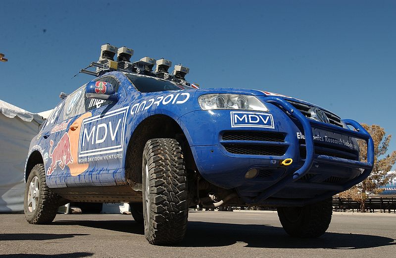
Artifacts: (Don’t you just love the word artifact? Indeed, someone once told me, and not unkindly, that I resemble that word.) The time exhibition features 144 artifacts, drawn primarily from the collections of the participating museums. Highlights of the exhibition include a representation of a 19th-century ship from the U.S. Exploring Expedition; the first sea-going marine chronometer made in the United States; the submarine navigation system for the USS Alabama; a TRANSIT navigation satellite (a major naval predecessor to GPS); Wiley Post’s airplane, the Winnie Mae; and Stanley, originally from the Stanford University Racing Team and written about many times by yours truly in GPS World. Stanley is a robotic vehicle that can drive itself. Stanley is a 2005 Volkswagen Touareg, which has been considerably modified to navigate without remote control and without a human driver onboard. Stanley handily won the 2005 DARPA Grand Challenge (Defense Advanced Research Projects Agency), a robotic vehicle race. Stanley successfully navigated 212 kilometers (132 miles) across desert terrain and has had his (here we go, anthropomorphizing automobiles) own robotic exhibit at the Smithsonian since 2009.
An official DARPA photograph of Stanley at the 2005 DARPA Grand Challenge. Stanley, created by the Stanford University Racing Team, won the race.
Organization: The current time exhibition is organized into five sections: Navigation for Everyone; Navigating at Sea; Navigating in the Air; Navigating in Space; and Inventing Satellite Navigation.
Theme: If you want to know where you are, you need an accurate clock. In other words, you need to know when you are. About 250 years ago, sailors first used accurate clocks, later known as chronometers, to navigate the oceans. Today, we locate ourselves on the globe with synchronized atomic clocks in orbiting satellites (GPS is the primary method today). Among the many challenges facing navigation from then to now, one stands out: keeping accurate time.
For centuries, nations have invested enormous resources to determine time and place for geopolitical reasons, and their research has changed people’s view of the world. Advanced technology that was once available only to the military has become commonplace and downloadable to cell phones, iPADS and computers. Instead of unfolding a map or stopping at a gas station to ask for directions, drivers can now consult their car’s GPS (Global Positioning) system. The new gallery examines the cultural and technological history of precise timekeeping and navigation at sea, in the air, and in space and the impact of satellite navigation on our everyday lives. Which of course are also the missions of the Institute of Navigation and GPS World magazine.
When Am I?
Many of you have heard the old saw about those who don’t know history being doomed to repeat it, and if you don’t know where you have been, how can you know where you are? There are probably numerous maxims that fit the bill when it comes to the history of time and navigation, and the Smithsonian Exhibit certainly does a great job of hitting all the high points, but beyond that, they will take you into about as much detail as you can stand. If possible, plan on attending the exhibit several times and delving into each of the five major themes. But if you can’t visit Washington, D.C., and the Smithsonian exhibit, then visit virtually on their excellent website.
For our purposes, suffice it to say that you can’t really know where you are unless you know when you are. That requires a clock, the more precise the better, and consequently the more accurate your position.
History Lesson
More than 200 years ago, sailors sailing between Europe and the New World knew where they were only in relationship to their latitude, but had no idea other than dead reckoning of their longitude.
Enter Boston clockmaker William Cranch Bond who, although he was not the first, constructed a specialized timepiece, which later became known as the Bond Chronometer, which sailors used to determine longitude at sea. But still there were problems. Sailors used a maritime sextant and chronometer to determine position, but both devices depended on the other. On cloudy or foggy days, either the horizon or the sun and stars or both were unavailable, and positioning/navigation was relegated to, in all seriousness, dead reckoning with a dubious magnetic compass, a rock and a rope. The problem being, of course, that dead reckoning made many mariners resemble the first word in that very unfortunate navigational phrase.
Time and Air Navigation
Fast forward almost a century (1903), and aeroplanes are now on the scene along with all the problems attendant in navigating a machine easily traveling ten times faster than most ships. But of course the U.S. Navy rationalized that if a watch and a sextant were good enough for navigating maritime ships, then they were good enough for ships of the air — even if the horizon was often obscured or moved around a great deal, or turbulence made balancing a sextant difficult.
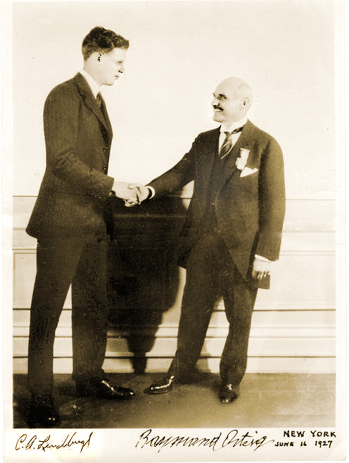
The result was most aviators gave up on the sextant, especially solo aviators, and just used a watch and, you guessed it, dead reckoning, which is exactly what happened to many aviators in 1927 who attempted to win the Raymond Orteig $25,000 prize for being the first solo aviator to cross the Atlantic nonstop from the East Coast of the U.S. — in fact, it had to be New York to Paris, France. For you trivia buffs, it had to be New York to Paris because the person offering the prize, Monsieur Raymond Ortieg, was an emigrant from France who did well for himself and went from a penniless restaurant busboy to owning two of the most prestigious hotels in New York City at the time. Hence the connection between New York and Paris. But I digress.
Charles Lindbergh (left) and Raymond Orteig.
Enter Lindbergh
As most of you are aware, then captain, later colonel, Charles Lindbergh took up that dare and won the Orteig-prize on the 21 of May, 1927, when he landed in Paris after a grueling 33½-hour solo flight across the Atlantic. When Lindbergh hit land after being “feet wet” for more than 30 hours and 3500+ miles, he was less than three miles from his intended European entry point, a feat that would be hard to duplicate today without GPS, as even with an unaided inertial system the drift can sometimes be as high as one kilometer per hour.
One part I always find amusing about the Lindbergh transatlantic saga is that after flying with “dead reckoning” as his only means of navigation for 30 hours across the Atlantic, he followed the Seine river all the way to Paris, so he essentially converted from VFR (Visual Flight Rules) to the IFR or “I fly rivers” navigation method for the last part of his journey.
Meteorologists and the sealed barometric equipment Lindbergh carried on board — to prove he never landed enroute or that it was indeed a non-stop flight — would not only verify that fact but also verify that he navigated the Atlantic in what we might call today The Perfect Calm. Indeed, Lucky Lindy picked the perfect 48-hour period for his flight. For those of you who read the book, saw the movie, or were there, will remember that in New York the weather during the night preceding his historic takeoff from the dirt-churned-into-mud runway at Roosevelt Field, Long Island, New York, was less than cooperative. There was a major thunderstorm with lots of lightning and several inches of rain; consequently, many counseled Captain Lindbergh to postpone his flight. But he would have none of it and the rest is history.
The most interesting part of the story, however, is that the entire flight was accomplished with “dead reckoning,” a compass and a watch, the very same tools that Captain Lindbergh used during his tenure as a U.S. Mail pilot. So, in fact, Lucky Lindy actually knew very little about navigating an airplane or avigation, as many called it at the time. Indeed, according to Roger Connor from the National Air and Space Museum and his wonderful article in this month’s Smithsonian Air & Space magazine, Even Lindbergh Got Lost, Captain Lindbergh did not learn to properly navigate with a sextant, chronometer and star charts until more than a year after his famous flight to Paris.
I won’t spoil the story for you, but he learned to navigate as did his famous wife, Ann Morrow Lindbergh, from then Lieutenant Commander Philip V.H. Weems of the U.S. Navy. LCDR Weems set up the nation’s first independent navigation school, and went on to instruct such notables as General Curtis LeMay, the Commander of Strategic Air Command (SAC), who went on to serve as the Chief of Staff of the USAF. Most people are not aware, but General LeMay was dual-qualified as a pilot and a navigator in the USAF. As the Commander in Chief of SAC or CINCSAC, he mandated that all SAC flight crews be able to navigate from Point A to Point B using only passive means that were always available and did not involve transmitting a signal outside the aircraft. In other words, celestial navigation, using a sextant, chronometer, special plotter and star charts, much as was taught by LCDR Weems.
I was one of the lucky SAC flight crew members who learned to navigate with those basic instruments. And checking my logbooks, I find that I made just short of 200 flights (99 round-trips) across the big pond, the Pacific that is, using those basic instruments. I mentioned this to a group of USAF aircrews recently during a speech, and when I asked how many of them could accomplish that feat if required to do so today, I was informed that sextants are no longer carried on USAF aircraft and most do not even have sextant ports. In other words, it is a lost art among flight crews today, and it is a shame, but it is also a topic for another time.
The important fact concerning navigation and time is that time — indeed, precise time — is and always has been critical to accurate navigation, especially aircraft navigation, no matter whether you are flying from New York to Paris, Texas, or New York to Paris, France. And GPS Atomic Reference Systems (Atomic Clocks) on orbit today, which deliver time accurate to millionths of a second, are even more critical since they are the heart of the system. So I would say to my journalist enquirer, GPS and atomic clocks are one and the same. You can’t navigate accurately without precise time.
Weems Legacy
Now, to bring this full circle, I first heard about the proposed Smithsonian Time Exhibit about two years ago from a friend and professional colleague, James Doherty, Captain, USCG retired. Jim, who once served as the Commander of the United States Coast Guard Navigation Center, is a past President of ION (Institute of Navigation), one of the few U.S. members of the Royal Institute of Navigation (RIN) in London, England, and now serves as the Chairman of the newly created Military Division at ION. And for full disclosure purposes, I must say that I have been a proud member of ION for more than 30 years.
Jim, who was serving on a Smithsonian panel as a subject-matter expert on navigation, told me that the Smithsonian had the idea for the time exhibit, but was looking for support, and the first organization to pledge support was indeed ION. The Institute of Navigation certainly does not have the deep pockets of Northrop and Exelis or the other major sponsors, but they are very serious about navigation and they are always looking for ways to promote their vision. This was the perfect opportunity.
And just in case you were wondering, the legacy that Captain, U.S. Navy, V.H. Weems left the world is a method of celestial navigation that persisted as the primary means, especially in the U.S. military and military forces around the world, for more than 60 years and is still the only reliable means of navigation available to us when everything else goes away. For with the Weems Method, as long as you have a sextant and an accurate clock, you can navigate anywhere.
Oh, and one other legacy: Captain V.H. Weems was the founder of the Institute of Navigation, which is the leading society devoted to the advancement of navigation in the world today. And for you trivia fans, the ION predates the RIN by two years.
Sequestration and Cancellations
Normally I would wrap it up here and say grab your sextant and happy navigating, but just as I wrap this up I have been told by informed sources at SMC and AFCEA that the GPS Partnership Council scheduled for May this year has been postponed. Sources at ION tell me that ION/JNC in Orlando has been cancelled for this year due to the restrictions on travel for U.S. government and military officials. In other words, more victims of sequestration and a Congress that can’t make the decisions we elect and pay them to make.
At ION they have always had the mantra, do it right or don’t bother doing it at all, and this year the travel restrictions are just too great. Certainly Jim Doherty and I were in the process of setting up another great Warrior Panel for the classified day, but that will have to wait for another time. However, I am assured by ION Executive Director Lisa Beaty that the ION GNSS meeting from September 16-20 at the Nashville Convention Center is definitely a go, so I look forward to seeing everyone there. Stop by the GPS World booth and say hello. Plus, I hope to see many of you at the 29th Annual National Space Symposium in Colorado Springs from April 8-11, 2013.
Until then, Happy Navigating – blow the dust off your sextant and give it a shot.