Category: Opinions

  • Survey Perspectives – Early March 2008

    Catching Up

    There has been a lot of activity on both the civilian and military sides of GPS/GNSS these past few weeks. Instead of a central theme to this newsletter, I’m going to comment on three points of interest: a DoD directive regarding position, navigation, and timing; PRN32; and some new product developments.

    New Department of Defense Directive

    On February 19, 2008, the Deputy Secretary of the U.S. Department of Defense (DoD) issued Directive #4650.05, which addresses, among other things, the “policy, procedures and responsibilities” for GPS. Although there will be many who will dissect and analyze the Directive for weeks to come, it’s clear that civilian influence on GPS continues to rise. You can read our Military and Government Editor Don Jewell’s initial comments here.

    Of interest to the survey/construction/mapping community is the fact that the Department of Transportation is specifically mentioned as a key external agency (external to the DoD) to have a say in GPS activities. The Department of Homeland Security and NATO were the other two key external agencies named.

    There is nothing earth-shattering about the directive, but it certainly sends a strong message that the federal government wants the civilian community — domestic and perhaps more so, international — to feel more comfortable about GPS, even though it’s still a U.S. military program.

    PRN32

    After a few months of waffling and discussion and announcements, PRN32 was finally set healthy. It’s been ready to go, but there has been concern about the effect that it would have on GPS receiver firmware. It was suspected that some GPS receivers wouldn’t be able to handle it, or would be adversely affected by it, because they may interpret PRN32 as PRN00.

    This isn’t the first time that DoD has used PRN32. PRN32 was used temporarily in the early 90s until it was discovered that some GPS receivers interpreted it as PRN 00. It hasn’t been used again until now, some 15 years later.

    Chances are that your receiver should be able to handle PRN32, given the event back in the early 90s and the DoD memo released more than a year ago. The satellite in question was set healthy on February 26, 2008. If your receiver is tracking but still not using PRN32, it may be worth a call to the dealer or manufacturer of your equipment to see if there is a firmware update available.

    Depending on your location, PRN32 may help you. I was in the field in the western United States a couple of weeks ago, for example (before PRN32 was set healthy). I was only using five GPS satellites with an RTK receiver while down in a hole, and my receiver was tracking PRN32. It was in a perfect part of the sky that would’ve probably allowed me to get the tough shot I wanted, had it been set to healthy at that time, but no dice. I’m going back to the same site in a few weeks, and I’ll be watching for it. The RTK receiver I was using is more than 10 years old, so it will be interesting to see how it handles a healthy PRN32.

    Product Announcements

    Normally, I leave the new product announcements out of the editorial area, but three recent ones deserve particular attention. I mentioned two of them, from Javad GNSS and Magellan, in my December column of who to look out for in 2008. Both companies have come through in short order.

    Javad GNSS. Early last month, Dr. Javad Ashjaee — former Trimble engineer and founder of Ashtech, Javad Positioning Systems (which was sold to Topcon in 2000), and Javad Navigation Systems — introduced the world to products developed by his new venture: Javad GNSS. In true Javad style, he’s pushing the envelope on both the technical side and the business side of the equation.

    Of course, it’s expected that Javad’s new product line would account for every signal available, and probably every one that is planned. No disappointment there. His Triumph technology sports 216 channels to track everything from GPS L1/L2/L5 to Europe’s E1/E5 Galileo to GLONASS L1/L2, as well as all SBAS signals. That’s no big news, though, as all the other major manufacturers offer similar products.

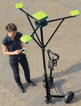
    What’s new and unique about Javad’s offering is the “RTK Umbrella.” The concept makes sense. The idea behind the RTK Umbrella is to increase the reliability of RTK positioning. A cluster of four antennas (on the rover) is used to compute sixteen baselines for every RTK measurement. Here is what the umbrella looks like.

    After looking at it, you’re probably thinking the same thing I am: How am I going to cart that thing around all day? The short answer is, you won’t. But I can see an application where one could use the RTK Umbrella for setting control and performing other geodetic functions that require a higher degree of reliability and integrity. Then, you could toss it into the back of the truck and just use the single antenna for the production work.

    It’s an interesting concept. I’ve got to give the guy credit for being creative.

    Magellan. Magellan has been noticeably quiet in the high-end, survey-grade survey business for quite a while. The roots of their high-end business came from Ashtech, which they acquired many years ago. Yes, they have the Z-Max.Net that they announced a couple of years ago, but in a world where multi-constellation GPS and GLONASS receivers are the norm, it’s a me-too product at best. To give credit where credit is due, Magellan has continued to dominate the lower-end L1 survey-grade receiver market with its ProMark series of receivers and more recently, its ProMark 3 RTK product.

    Now, as the company has been threatening to do (albeit under its breath), it has placed both feet squarely back in the high-end survey receiver business with the ProMark 500, a multi-constellation receiver that places Magellan in the same class as the best Trimble, Topcon, and Leica receivers. Granted, there is not a lot of information available on the ProMark 500, other than the video on its website. The real test will be when Magellan starts to ship the product, and dealers and users begin to run it in production mode.

    My guess is that the technology will be pretty good. I think one of the biggest challenges will be to rebuild their surveying distributor network. With Topcon and Leica buying up distributors like candy in the past twelve months, the pickin’s are getting pretty slim.

    Trimble. Remember when the Trimble ProXRS was the cream of the sub-meter mapping crop of receivers? It was a L1 C/A code workhorse of the past decade around the world. Then, it faded away when the ProXT/ProXH receivers were introduced. But neither of those really replaced the ProXRS.

    Now, Trimble has upped the ante by introducing the ProXRT. The ProXRT offers users a range of accuracy depending on their needs, from sub-meter down to decimeter (10cm) accuracy. Perhaps the most significant feature is that the ProXRT is capable of using the Russian GLONASS satellites as well as GPS. The product announcement implies that GLONASS signals are used when GPS satellite availability is impaired. I have two comments about GLONASS on mapping-grade receivers.

      1. Unless you are using your own GPS/GLONASS reference station, the GLONASS signals used on a mapping-grade handheld will be uncorrected (autonomous). Virtually no CORS receivers have GLONASS capability; neither NDGPS nor WAAS/EGNOS use GLONASS. So, there are no free public correction sources for GLONASS like those we are used to with GPS. However, many RTK networks are broadcasting both GPS and GLONASS corrections.


    1. Autonomous GLONASS measurements offer much worse accuracy than autonomous GPS measurements, by a factor of five. This is because of the inferior clock and ephemeris data.

    However, if used in the right circumstances, tracking a GLONASS satellite(s) can be the difference between getting a measurement or no measurement at all — even if the accuracy of the position takes a hit.

    Another feature that the ProXRT brings back, which was curiously missing from the ProXT and ProXH, is OmniSTAR capability. The ProXRT is capable of using OmniSTAR’s VBS, XP, or HP service. This, of course, means that the ProXRT is a GPS L1/L2 receiver.

    I’ll be attending the annual ACSM Conference on Thursday of this week. I’ll keep my eyes open for any other new developments. I’ll probably blog or otherwise comment on the conference somewhere on the GPS World website, as that is becoming our modus operandi when attending conferences. I like that format, and it brings you a bit closer to what’s happening if you are unable to attend the conference yourself.

  • Expert Advice: GLONASS Business Prospects

    By VASILIY ENGELSBERG, IVAN PETROVSKI, and VALERY BABAKOV


    Similar in many aspects to GPS, GLONASS has performed much less successfully on a commercial scale, failing — so far — to create significant business worldwide. Today, however, the commercialization of GLONASS has taken a new and more promising direction, receiving strong encouragement from the Russian government. We look forward to GLONASS being completely restored to its full operational capabilities within the next few years, and we are certain that this time GLONASS will create successful business opportunities worldwide.

    Why did GLONASS fail to create a worldwide business opportunity in the past? First, many GLONASS satellites of the first generation had required replacement at approximately the same time. This coincided with a difficult period for the Russian economy, after the collapse of the Soviet Union and much of its infrastructure. Budget for space applications suffered, not only for GLONASS, but other space programs that were temporarily frozen. Many companies that had started to work on combined GPS/GLONASS receivers worldwide stopped these initiatives at that time.

    The other reason for GLONASS’s halting commercial history is in its frequency division multiple access (FDMA) signal structure instead of code division multiple access (CDMA), as is the case with GPS, and now Galileo. FDMA, though more immune to interference, results in bulkier user equipment. Today the situation may change in two respects. First, there is a possibility of introducing CDMA within GLONASS. Second, and even more important, today GNSS user equipment progresses toward multifrequency anyway with all the possible combinations of GPS, Galileo, L1, L2, and L5. It will ultimately boost the technology, and even multifrequency and wide-band RF components will be miniaturized.

    All these considerations allow us to confidently foresee exceptional opportunities for GLONASS-related business tomorrow.

    Policy. Today, GLONASS is required for social infrastructure within Russia for all federal users. President Vladimir Putin has paid special attention to rapid GLONASS development, urging completion of the system ahead of the original plan.

    As expected, three more GLONASS-M satellites were launched by the end of 2007, and have since been declared operational. GLONASS-M satellites have a guaranteed lifespan of seven years, that is, the lifespan of these satellites runs until the year 2015.

    There is also a new generation of satellites, GLONASS-K. This upcoming modification represents an entirely new concept based on a non-pressurized platform. The estimated service life of GLONASS-K satellites has been increased to 10–12 years, and the spacecraft will carry an additional third civilian L-range frequency.

    GLONASS-K is smaller and considerably lighter than previous models, allowing the use of a wider range of launch vehicles and thus making them less costly to put into orbit. The weight of a GLONASS-K satellite falls to 700 kilograms instead the of 1,415 kilos of previous satellites. After the complete constellation is deployed, it will require one Soyuz launch per year to maintain the constellation in full.

    We expect that at least six GLONASS-M satellites will be launched in 2008, and six more in 2009. There will also be two GLONASS-K satellites launched in 2009. The earlier satellites with three-year lifespans will be decommissioned.

    Altogether, there should be 24 satellites in near-circular orbits with 64.8-degree inclination in three orbital planes. Initially, system completion was planned by the year 2012, but with close attention from the Russian government, the system may be deployed in full scale by the end of 2009.

    Interoperability. Moving as planned toward interoperability with GPS and future Galileo, the GLONASS coordinate frame had been changed. According to the Russian Federation government decree issued on June 20, 2007, the improved version of the national geocentric coordinate system “Earth Parameters 1990” (PZ-90.02) has been applied to GLONASS. The transformation between PZ-90.02 and the International Terrestrial Reference Frame ITRF2000 contains only origin shifts along X, Y, Z by –36, +8, and +18 centimeters, respectively. An update to the GLONASS Interface Control Document has already been published and made available trough the Internet. The update to ICD, current information on GLONASS status, and a current almanac is available from the Information-Analytical Center (IAC).

    Worldwide Use

    All restrictions on positioning service in Russia were lifted in January 2007, including a restriction on allowed positioning accuracy. This was one of the barriers that limited GLONASS commercialization in the past.

    Today, GLONASS plus GPS user equipment appears more and more frequently in stores in Russia. It is now necessary and highly popular equipment for airplanes, marine applications, surveyors, mapping applications, and so on.

    What advantages does GLONASS offer to worldwide users who already have GPS? Due to its orbit inclination, GLONASS provides better coverage than GPS in northern latitudes. It was designed for use in the territory of the former Soviet Union and Europe. The combined usage of the two systems allows better coverage over the full globe.

    FIGURE 1. GPS (green) and GLONASS (pink) constellation visibility in Tokyo for 48 hours. Note that GPS visibility picture repeat itself every 24 hours, and GLONASS visibility changes. It also illustrates why GLONASS satellite orbits are less affected by gravitational filed irregularities.
    FIGURE 1. GPS (green) and GLONASS (pink) constellation visibility in Tokyo for 48 hours.
    Note that GPS visibility picture repeat itself every 24 hours, and GLONASS visibility changes.
    It also illustrates why GLONASS satellite orbits are less affected by gravitational filed irregularities.

    Further, more systems mean more reliable service. Healthy competition will only benefit users. Compatibility of the systems had been be improved and will be improving further. Two systems will provide higher accuracy and higher integrity.

    The international GLONASS market can increase due to the fact that countries that do not own their satellite navigation system can provide some redundancy in their infrastructure if they implement GNSS from different owner/operators. This, however, becomes less important as other navigation satellite systems, such as Galileo, come to life. Also, more satellites will benefit users, who operate in urban or other obstructed environments.

    Accuracy. It has been generally accepted that the real-time accuracy of GLONASS is less than that of GPS. The main source of accuracy degradation comes from broadcast ephemeris and clock parameters. For many users, it is possible to use precise ephemeris, freely available on the Internet from, for example, the International GNSS Service (IGS), formerly the International GPS Service, a voluntary federation of more than 200 worldwide agencies that pool resources and permanent GPS and GLONASS station data to generate precise GPS and GLONASS products.

    We also have analytical centers similar to, and some within, the IGS. Four analytical centers wi
    thin the IGS are estimating GLONASS ephemerides, and two of them are estimating GLONASS clocks. The accuracy of precise GLONASS ephemeris are within 4 centimeters, 1 sigma.

    Using precise ephemeris, or differential service, a GLONASS user can mitigate the above-mentioned error sources and enjoy higher accuracy comparable with those of GPS. In the future, a global network, even a commercial one, can further benefit GLONASS in terms of higher real-time accuracy.

    Summarizing, we expect the GLONASS market worldwide to grow, though less rapidly than the internal market in Russia. We see our business in providing global solutions, which includes GLONASS, GPS, and Galileo, to the global market of GNSS users worldwide. The standard for navigation systems in the future will be multifrequency, multi-constellation user equipment, and we are well on the way to meeting this standard.


    VASILIY ENGELSBERG is president of NVS Technologies AG and co-founder of NAVIS.

    IVAN PETROVSKI is NVS director. Among his numerous responsibilities, he is in charge of research and development and the Asia-Pacific region.

    VALERY BABAKOV is co-founder and general manager of NAVIS. Babakov explains, “Our company is a center of the NAVIS group, which is the main supplier of GLONASS receivers in Russia. NAVIS itself is about a 300-person company. The main area of our activity is the creation of navigation and timing equipment, based on GLONASS/GPS signals.

    “We produce technologies and equipment that use GLONASS and GPS signals, including navigation equipment for marine and airborne applications, devices of time-and-frequency synchronization for communication systems, and GPS, GLONASS, satellite-based augmentation systems (SBAS), and Galileo simulators.Our current GPS/GLONASS receiver Navior seems to present interest to a wide range of customers worldwide. “Working in today’s market, we are covering all components of user service starting from conceptual engineering, to technical project development, delivery, assembling and launching of equipment, and finally providing users with training, technical support, and maintenance during exploitation.

    “As part of the process of integration of our technologies into the worldwide GNSS market, NVS Technologies had been established. NVS Technologies is a new company, which aims to bring a wide range of GNSS products to the market and is envisioned to combine the experience of Russian NAVIS and NAVIS Ukraine in GPS and GLONASS user equipment development with Swiss quality and expertise in international marketing.

    “Our company group now is not only engaged in the GLONASS business, but also looking forward contributing to Galileo equipment development. We are participating in the Galileo Integrated Receiver for Advanced Safety of Life Equipment (GIRASOLE) project together with Thales Avionics and Thales Aleniaspace. Our part in the GIRASOLE project is to provide the Galileo L1/E5 simulator. To facilitate simulator development, we have built a Galileo prototype receiver, which can acquire and track the GIOVE-A signal. Working with our SN3806 simulator, the receiver can also make a positioning. In November 2007 our engineers conducted a three-day tutorial on our GNSS simulator in Thales Avionics premises in Valence.”


  • Survey Perspectives – Late February 2008

    With nearly 60 GPS engineers and scientists, the Jet Propulsion Lab (JPL) is one of the biggest GPS R&D centers in the world today. It operates as a division of the California Institute of Technology (Caltech), which manages the lab for the National Aeronautics and Space Administration (NASA).

    Among other things, JPL operates the Global Differential GPS (GDGPS) system, which sells technical services and data and licenses software. The GDGPS system within JPL employs a vast, worldwide network of more than 100 L1/L2 GPS reference stations owned by itself and its partners.

    Each reference station streams GPS measurements back to the GDGPS Operations Centers once per second. Data is then processed and analyzed in real time. Talk about redundancy — each GPS satellite is always observed by at least ten reference stations, and twenty-five is typical. Read more

    It’s easy to get lost in JPL’s wide array of GPS product and service offerings, so I’ll try to stick with the part that’s closest to survey and construction.

    Among other activities, JPL has people dedicated to monitoring and modeling the atmosphere — especially the ionosphere, which strongly impacts GPS measurements. They provide real-time, global maps of the Total Electron Content (TEC) used for L1 differential corrections around the world (think SBAS like WAAS and MSAS) and also for predicting ionospheric storms.

    Dr. Michael Whitehead of Satloc, Inc. (now a division of Hemisphere GPS, Inc.), lead the first Wide-Area Differential GPS (WADGPS) commercial ventures to license JPL’s clock/orbit correctors and iono modeling services. This was back in the mid-90s, and Satloc’s target market was agriculture. Remember, this was before Selective Availability (SA) was turned off, so without a source of corrections, horizontal GPS accuracy without augmentation would routinely blow out to 100 meters. With its system, Satloc was able to deliver sub-meter L1 corrections to users via communications satellite.

    “They (JPL) provided core technology. It worked great. The accuracy was there,” said Whitehead.

    Whitehead said Satloc operated its own GPS reference network and internal software for generating corrections, but it also used JPL’s service to provide system redundancy. The Satloc system was set up to use corrections from either system (Satloc or JPL), and could automatically switch between the two systems.

    The Satloc network was eventually sold to Fugro/OmniSTAR, another WADGPS service provider that integrated JPL data into its product offering. Hemisphere GPS/Satloc products now rely on WAAS (Wide Area Augmentation System) for their source of corrections. WAAS is built on core JPL technology, a predecessor of the GDGPS software. According to Whitehead, WAAS is very similar to the system that Satloc originally developed.

    Fugro/OmniSTAR

    Fugro/OmniSTAR operates its own GPS reference station network (over 100 worldwide, with 21 of those in North America) and has offered a WADGPS service in certain regions of the world dating back to the late 80s on a subscription basis. Until the late 90s, OmniSTAR/Fugro was a “one-trick pony,” offering a sub-meter “VBS” service for L1 GPS receivers. This is based on its worldwide network of GPS reference stations. Since then, the company has expanded its services in response to demand for greater accuracy and system redundancy.

    Now, Fugro/OmniSTAR offers two additional levels of service: HP and XP. Both require the user to have a dual-frequency receiver (L1/L2). The upside is that the HP service provides +/-10cm horizontal accuracy using carrier phase (a sort of float solution). The HP service is based on Fugro/OmniSTAR’s proprietary GPS reference network and software. HP service is available in various regions throughout the world such as North America, parts of South America, Europe, the Middle East, Central Asia, and Australasia. The HP service is reference-station-dependent, meaning that the performance degrades as the user moves farther away from the nearest reference station (with a 300-mile limit).

    Fugro/OmniSTAR’s other precise service, XP, is based on data licensed from JPL. The XP service offers horizontal accuracy of +/-15cm. The HP and XP services are similar in accuracy, but the JPL-based XP service offers global service rather than a regional service like HP. The difference is that while the HP service is baseline-dependent, the JPL-based XP service is not. That enhances Fugro/OmniSTAR’s coverage in remote locations where reference station coverage is sparse.

    NavCom Technology

    A leading-edge GPS design company licensing data from JPL is NavCom Technology, Inc., from Torrance, CA. Although the company name isn’t well known in the Survey/Construction industry, many of the engineers at NavCom are the same ones that designed the original Leica survey receivers while they were at Magnavox. There is some pretty high-end GPS design talent there — enough that John Deere Company bought NavCom, which now operates as a wholly owned subsidiary of Deere.

    NavCom created and operates a GSBAS (Global Satellite-Based Augmentation System) called StarFire. While NavCom operates its own network of 20 worldwide GPS reference stations, it also has license agreements with JPL for reference station data and certain software. NavCom then refines and optimizes the data for NavCom receivers and distribution via the StarFire network. The result is that StarFire can deliver horizontal accuracies in the sub-10cm range after initialization.

    NavCom has also created an interesting innovation it calls RTKExtend. Users of traditional RTK systems know that when the data link is interrupted, RTK operations are halted until the data link can be re-established. However, NavCom has combined traditional RTK with its StarFire network to assist RTK users. Users begin work using the traditional base/rover RTK configuration. If the data link is interrupted, the NavCom receiver automatically transitions to use the StarFire network, so the user can continue to operate at the centimeter level for up to 15 minutes.

    Satloc, Fugro/OmniSTAR, and NavCom are just a few examples of commercial organizations that have successfully utilized JPL’s leading-edge GPS technology. There are also applications outside of the high-precision industry, such as mobile phone service providers licensing JPL to provide A-GPS data for E-911 anywhere in the world. With its unique global reach, JPL’s technology enables precision GPS applications even in regions of the world that lack infrastructure. It’s truly impressive to realize that decimeter-level positioning is available in most places in the world today; it’s just a matter of how to deliver the corrections. With the proliferation of wireless communications, even this problem will eventually be solved.

  • Survey Perspectives – Early February 2008

    DOT Throws NDGPS a Life Preserver

    It appears the US Department of Transportation has bought the Nationwide Differential GPS system (NDGPS) another year. The FY09 Presidential Budget Request was released earlier this week, and it contains a line item in the Research and Innovative Technology Administration (RITA) budget for NDGPS in the amount of $4.6M for operations and maintenance of the current system until October 2009. There is no budget item for the planned build-out of NDGPS. The budget request is subject to approval by Congress, but most likely this will go through.

    The funding request is neither a thumbs-up nor a thumbs-down for NDGPS. The FY09 $4.6M budget request for NDGPS merely means that the DOT hasn’t figured out what to do with NDGPS yet, and the pain of having to fund a decommissioning program outweighs the $4.6M to keep it running for another year.

    I think it’s the right decision. That may be intriguing to some of you who have followed my criticisms, but they have principally been directed at the stewards of NDGPS, not the program itself. RITA, regardless of how incompetent it has been at trying to understand this, needs more time to have a chance of comprehending how NDGPS is used.

    Last year, RITA was funded $400,000 for a “needs assessment” of NDGPS. In other words, the administration is supposed to study and understand who is using NDGPS. Their primary attempt at this was opening a formal docket for accepting public comment last fall. You can read the Federal Register Notice here.

    With an initial deadline for public response of October 1, 2007, the responses were very weak; about 30 comments were collected. The deadline was ignored by DOT, and more comments have been trickling in, with the last one posted January 28, 2008. As of February 4, 2008, there were 124 comments. However, because the explanation in the docket was written so poorly, some of the comments are not about NDGPS and obvious confusion exists between NDGPS, CORS, and OPUS. I read through every comment submitted.

    After culling out the statements from by people who didn’t understand NDGPS or made meaningless comments, nearly one-third of the responses in favor of NDGPS were from National Park Service employees. Several submissions represented federal and state government users, from agencies such as the USDA, state DNRs, state DOTs, state geodetic surveys, and county and local governments. It’s hard to assign a number of users to those sorts of submissions, though. For example, in the USDA comment, it claims to have 7,000 GPS receivers in use nationwide, but you and I know that only a very small percentage use the NDGPS stations being considered for decommissioning. The USDA commenter also wrote that the loss of CORS “would have a severe impact on high-accuracy positioning.” Well, that’s not the case, so discounts the credibility of the agency’s support.

    It’s sad that a pioneering GPS program such as NDGPS is being treated as it is today. Whether you support NDGPS or not, it has earned a fair shot — and it’s not getting it. That’s why I agree with the decision to fund it for another year while RITA pulls itself together. It will be very interesting to read the results of RITA’s $400,000 “needs assessment” report that was due to be completed January 30, 2008. If it’s anything like the joke of a report entitled “NDGPS Study” that was presented last fall at the CGSIC meeting in Ft. Worth, just go ahead and shoot me now.

    Since the RITA docket failed to communicate to the public just what effect the loss of 26 NDGPS site would have for both NDGPS users and CORS/OPUS users, I’ll attempt to spell it out here, as clearly and concisely as possible.

    What’s at Stake?

    If the 26 NDGPS sites cease to operate, you will not be able to receive DGPS corrections from these sites.

    Map of current DGPS and NDGPS sites:

    Click to view details

    Map of DGPS system minus the 26 NDGPS sites:


    Click to view details

    Following is a list of the 26 NDGPS sites on the chopping block:

    • Hackleburg, AL (HAC)
    • Flagstaff, AZ (FST)
    • Bakersfield, CA (BKR)
    • Chico, CA (CHO)
    • Essex (Fenner), CA (CAE)
    • Pueblo, CO (PUB)
    • Macon, GA (MCN)
    • Hagerstown, MD (HAG)
    • Pine River, MN (PNR)
    • Billings, MT (BIL)
    • Polson, MT (PLS)
    • Greensboro, NC (NCG)
    • Medora, ND (MDR)
    • Whitney, NE (WHN)
    • Albuquerque, NM (ABQ)
    • Austin, NV (AST)
    • Hudson Falls, NY (HDF)
    • Klamath Falls, OR (ORK)
    • Seneca, OR (ORS)
    • Hawk Run, PA (HRN)
    • Clark, SD (CLK)
    • Dandridge, TN (TND)
    • Hartsville, TN (HTV)
    • Summerfield, TX (SUM)
    • Myton, UT (MYT)
    • Spokane, WA (SPN)

    What Alternatives Exist?

    If you depend on one of the above sites for DGPS corrections (not CORS or OPUS but beacon corrections), what are your alternatives if the site is shut down?

    1. The easiest choice is to switch to WAAS as a correction source. Most receivers are WAAS-enabled and, like NDGPS, it’s free. However, you’ll need to reconcile the horizontal datum difference between the two. NDGPS uses NAD 83(CORS96) and WAAS uses WGS-84(G1150). I’ve done this many times; it’s not difficult, but it needs to be done or you will introduce 1+ meter error.

    Caveat emptor. Some GPS receivers handle WAAS better than others. Check for firmware updates from the manufacturer of your equipment. Also, some receivers don’t handle WAAS well when you are working under tree canopy or around buildings.

    2. If you don’t require real-time corrections when you’re in the field, then you can choose to post-process your data. Post-processing software is fairly automated these days, but inconvenient nonetheless.

    3. If you absolutely need submeter positioning in real time and your receiver isn’t capable of providing that via WAAS, there are several options.

    OmniSTAR is a commercial provider of submeter and decimeter corrections. It may or may not work where you work, however, because it’s got a line-of-sight limitation. If you’ve got a GPS receiver with an OmniSTAR receiver already built in (e.g., Trimble ProXRS), then it would be relatively painless for you to try it. I seem to recall that OmniSTAR has a trial program of sorts.

    RTK networks are popping up all over the country. Some are able to provide submeter corrections to mapping receivers via a mobile phone. Mobile phone data plans are relatively inexpensive, and you may even be able to rent one from a local GPS dealer when you need it. Most RTK networks charge a subscription or membership fee, but it doesn’t hurt to ask how they could accommodate you.

    Believe it or not, it’s not that hard to take control by setting up your own portable base station and broadcast corrections. Yes, you need two GPS receivers (one to generate the corrections), and you need a way to get data from one receiver to the other (UHF radios, spread-spectrum radios, NTRIP, etc.), but it’s doable. It’s a little painful to put the system together, but once you’ve done it, you’re set for life. You don’t rely on anyone else.

    Effects on CORS/OPUS Users

    In shutting down the 26 NDGPS sites, one piece of collateral damage would be the loss of CORS and OPUS for post-processing using those sites. Is it an issue? For CORS and OPUS users, it’s not; for OPUS-RS users, it might be. I’ll explain.

    First, let’s get definitions out of the way. When I write CORS, I’m referring to accessing RINEX data for L1 C/A post-processing. That’s you folks who use a Trimble Pathfinder, ProXR, etc., and post-processing the data to obtain meter-level accuracy. When I write OPUS and OPUS-RS, I’m referring to the National Geodetic Survey’s Online Positioning User Service, whereby you submit L1/L2 data and have their OPUS post-processing software reduce your data to centimeter-level accuracy and return corrected coordinates to you.

    For CORS users, the loss of your favorite NDGPS site won’t affect you, except that you’ll have to use either the next-closest CORS site or a regional reference station from the US Forest Service or state/local government. There are a ton of them around, so that shouldn’t be a problem.

    For OPUS users, the loss of the NDGPS sites won’t affect you. OPUS provides good results when using sites that are 500, 600, and even 700 kilometers away. If you go to http://www.ngs.noaa.gov/OPUS and click on Recent Solutions, you’ll see solutions from as far away as South America. I interviewed Dr. Dru Smith from the National Geodetic Survey in September 2006, and even back then, he said the days of needing to “use your favorite CORS” station are over. The OPUS software, he said, is designed such that an increased baseline distance is not an issue to be concerned with given the high density of CORS stations.

    For OPUS-RS users in certain areas, the loss of the NDGPS sites may affect you. The difference between OPUS and OPUS-RS, to the user, is that OPUS occupations require a minimum of two hours, whereas OPUS-RS only requires a minimum of 15 minutes of occupation time. But a limitation of OPUS-RS is that the user position must be within 250 kilometers of three CORS; those three CORS stations must surround the user position (think good geometry). In certain regions, that will create a problem for users.

    NGS has already conducted preliminary studies, determining that CORS coverage for OPUS-RS users in some regions of the country is deficient even with the NDGPS sites still active. Northern Maine, northern Minnesota, North and South Dakota, Iowa, Nebraska, Montana, Wyoming, Idaho, and northeastern Washington have been identified as deficient regions for OPUS-RS users, according to Dr. Richard Snay of NGS. Decommissioning the NDGPS sites in those areas would magnify the problem. On a positive note, Snay did say that NGS will soon be adding several CORS from the Minnesota Department of Transportation, so that will help OPUS-RS users in the region.

    What’s the solution for the OPUS-RS users who would be affected if the DOT decommissions the 26 NDGPS sites? The easiest, and only, solution I’d recommend is to revert back to using the original OPUS program. This means planning for two-hour occupation times instead of 15 minutes. Secondly, I’d start lobbying your state DOT, county, and whoever else might be interested in setting up a cooperative CORS site in your area.

    In summary, the impact of shutting down the 26 NDGPS sites has a minimal impact on CORS/OPUS/OPUS-RS users.

    Back to the Budget

    The FY09 NDGPS funding request is still only good enough to stop the bleeding for another year; it doesn’t solve the problem. When its study is completed, I seriously doubt RITA is going to find enough transportation applications to justify continuing to fund NDGPS under the DOT umbrella. Realistically, it’s going to be up to federal and state government users in the affected regions to pony up the funding. You can bet that no private entities are going to contribute significant funds, if any at all. They’ll find another solution before going down that road

    Listed below are some of the major government supporters (or associations who represent government agencies) that submitted public comments in support of NDGPS. I think it will be up to them, and others, to come up with at least the Operations/Maintenance budget of approximately $5 million annually to sustain (not build out) the NDGPS as it is today.

    • USDA (including US Forest Service)
    • National Park Service
    • Farm Service Agency
    • Bureau of Land Management
    • Maryland DNR
    • Iowa DOT
    • South Dakota Association of Local Government
    • California DOT (CALTRANS)
    • State of South Dakota
    • Association of American Railroads
    • North Dakota DOT
    • North Carolina Geodetic Survey
    • North Dakota Water Commission
    • Washington DOT
    • Idaho DOT
    • National Association of State Departments of Agriculture
    • Virginia DOT
  • The Holy Grail of GIS in Alabama?

    Virtual Alabama, a system for sharing homeland security data, serves as a model of success for other states to follow.

    By Art Kalinski, GISP

    One weekend a few years ago, like most good GIS professionals, I was randomly reviewing USGS topo maps for fun. No, I’m not that far gone; I was actually searching for a retirement location. I noticed a region of northeast Alabama that featured a large lake surrounded by good-sized foothills. My wife, Connie, and I drove out to Lake Guntersville and fell in love with the place.

    The peninsular town of Guntersville, which was still fairly undiscovered at that time, reminded me a little of Newport, Rhode Island. Lake Guntersville was twice the size of the landlocked Lake Lanier near our home in Atlanta, not to mention uncrowded and always at full pool. It offered superb sailing, fishing, and navigable water to Knoxville, the Gulf of Mexico, and even up to Lake Michigan. We bought a place and finally moved there permanently in December.

    Now Alabama is certainly not the first state that comes to mind when one mentions technology, but little did I know that 30 miles north of Guntersville, in Huntsville, that stereotype was being shattered. Alabama was working on a system to communicate and share data for homeland security, creating a model that other states are now emulating.

    The effort was initiated by Governor Bob Riley, who was frustrated by the lack of information he experienced while trying to respond to Hurricanes Dennis and Katrina in 2005, as well as tornadoes in 2003 and 2007. He instructed Jim Walker, his Department of Homeland Security (DHS) director, to fix the problem. As a retired Army lieutenant colonel, Walker tackled the issue with the same determination that had served him so well on active duty. He formulated the concept for Virtual Alabama; then, for implementation, he turned to the technical talent that was prevalent in Huntsville at the research park, the Redstone Arsenal, and the U.S. Space and Rocket Center.

    For decades, at GIS conferences and in classrooms across the country, we’ve heard the ultimate dream repeated: GIS would become a universal data integrator; it would provide all users with a common operating picture while mining data from many different sources. Finding this holy grail of GIS has been an uphill struggle, with seekers achieving varying degrees of success.

    Virtual Alabama is unique among the myriad of efforts to reach this goal — unique in both its approach and its results. The system was developed by Norven Goddard, the assistant director for science and technology of Alabama DHS, and Chris Johnson, the vice president of geospatial technologies for the U.S. Space and Rocket Center. Goddard is on loan to DHS from the Army Space and Missile Command’s Future Warfare Center, where he serves as assistant director for science and technology. His technical staff includes Amy Robison and Justin Novak.

    Goddard researched and tested every possible GIS viewing system, some common and some less well known. His search of systems included ESRI, Intergraph, Google Earth, NASA’s World Wind, Falconview, Skyline, Battlescape, and others. Goddard had several criteria that he wanted to meet. The system had to be cheap, easy to use, robust, able to ingest all data formats (vector, raster, and tabular), scalable, capable of supporting many simultaneous users, and sustainable. The one system that floated to the top was Google Earth — Google Earth Enterprise, in particular. With Google Earth the system could ingest the primary GIS data sets built in ESRI or Intergraph environments, it could serve the data to many users, and it was simple to use. In addition, the system is secure using Google Earth Enterprise, since it doesn’t touch Google Earth.

    It’s interesting to note that the Google Earth technology was originally created by a company called Keyhole, under contract to the CIA. Google bought the rights, but the “K” in KML still points back to the file format’s origins. Even more interesting is that the wheel has come full circle, with more than 21 states — and several federal agencies involved in homeland security — carefully reviewing the success of Virtual Alabama as an example of “best practices” and rediscovering the old Keyhole effort, enhanced by the people at Google and in Alabama.

    The statewide data sets include all available county GIS data, such as political boundaries, roads, rivers, streams, lakes, highways, parcels, floodplains, etc.

    The system has evolved into a very sophisticated spatial data integration and viewing system that is accessible by every state agency. In addition to the standard vector data (points, lines, and polygons), the system has been expanded to include ortho-imagery, scanned USGS topo maps, and now photo-realistic 3D models built from high-resolution oblique imagery.

    An example of 3D models built from high-resolution oblique imagery. Image courtesy of PLW ModelWorks/Pictometry.
    An example of 3D models built from high-resolution oblique imagery. Image courtesy of PLW ModelWorks/Pictometry.

    The system can be used to drill down through multiple data layers or view 3D fly-through models, and it can even show detailed CAD floor plans and building interiors created in SketchUp. The system can also show the effects of floods and display plume footprints from Cameo/Aloha.

    Floodplain data displayed in Google Earth shows the scope of buildings affected by a potential flood.
    Floodplain data displayed in Google Earth shows the scope of buildings affected by a potential flood.

    Those of you who have tried to establish such a system may have already guessed that some of the toughest hurdles were institutional, not technical. Virtual Alabama couldn’t be a system that relied on creating all the data; the cost of doing that would have been a showstopper. Instead, if there was to be any chance of success, the data had to come from local sources. But with the prevailing attitudes toward data ownership, cost recovery, and people jealously guarding their data, any statewide system was going to be a challenge.

    The Virtual Alabama team enlisted the aid of county sheriffs who, in Alabama, are the second-highest-ranking public officials in their counties. Since this was a homeland security issue, the sheriffs were very willing participants, and they had the clout to make it happen. Additionally, as the system was growing, no one wanted to be the only holdout county that wasn’t part of this “mutual aid” resource.

    Being Google-based helped with quick learning and adoption, as many users had already learned the basics of Google Earth on their home computers. At first the GIS community felt threatened, because this was not a “true GIS,” and it was much too easy to use. After all, most GIS people felt that they were the gatekeepers of mapping.

    Soon, however, the reality changed perceptions. The number of users viewing data and creating maps exploded, as did the demand for better and more up-to-date GIS data. The GIS shops found themselves doing the higher-level work of building, updating, analyzing, and serving GIS data, rather than just cranking out maps. Virtual Alabama started as a DHS effort, but its use has spread to 34 state agencies with about 2,200 users — most without GIS backgrounds.

    Each county continues to create and maintain its own data. The updates or expanded data sets are uploaded to Virtual Alabama continuously. New capabilities are being added weekly, including the ability to inset and register photos of disaster locations taken from news or police helicopters. Another advantage of the system is that counties that may not have the resources to create their own sophisticated GIS can still benefit by using the ready-built system and available data as a starting point for their own operation.

    Everyone wishes that Virtual Alabama was a fully fleshed-out system with the same level of detail for all data layers, but it’s not. It’s still a work in progress that now has momentum and a broad array of motivated individuals building data elements to expand and increase the level of detail. As non-GIS-trained users learn more, they want more, and are willing to help. For instance, firefighters who in the past created paper ledgers of data relating to buildings and their contents are now creating floorplan CAD files or SketchUp models.

    These SketchUp models were built by local firefighters using Alabama orthoimagery.
    These SketchUp models were built by local firefighters using Alabama orthoimagery.

    Now here is the real shocker. Are you ready? The total cost of setting up Virtual Alabama was just $150,000.

    As I’m writing this article, several southern states are recovering from a huge weather event that spawned many tornadoes and killed, at last count, 55 people. I know that Alabama DHS is making good use of Virtual Alabama to respond to the storm and aid recovery efforts.

    Tornado-damaged buildings are visible in this image, which was taken from a police helicopter.
    Tornado-damaged buildings are visible in this image, which was taken from a police helicopter.

    This does highlight the fact that these disasters know no political boundaries, and that “mutual aid” and “interoperability” are not just buzzwords. If your agency needs to have access to GIS data and to create a common operating picture, take a serious look at the success of Virtual Alabama. This is a critical — and practical — high-tech system from the home of real rocket scientists.

  • Survey Perspectives – Late January 2008

    3D Machine Control

    One of the hotter topics in the construction industry these days is GPS/GNSS. If any of you attend the World of Concrete exhibition in Las Vegas, you’ll see many examples of how GNSS is being implemented in construction environments. The exhibition is expected to attract more than 1,700 exhibitors and 90,000 attendees this month. I’m sorry I’ll miss it this year, but if you do attend, you’ll find the usual GNSS (and related) suspects exhibiting: Topcon, various Trimble divisions, Leica, Sokkia, Seco Mfg, CST/Berger, Berntsen, etc.

    Although the U.S. real estate construction market is clearly slowing (or shall I say dying?), the commercial construction market seems to be holding its own for the time being. The demand for construction automation equipment is still there, but I hear more about construction (and surveying) outfits wanting to rent GNSS equipment as opposed to buying it. This makes sense, as confidence in the economy is clearly waning.

    Regardless of construction industry trends, there’s no lack of equipment automation opportunities (GNSS-wise) in the construction industry. Of course, precise positioning (topo surveys, construction staking, grade checking, establishing control, etc.) is one area of opportunity, but there’s also not-so-precise positioning, like navigating to job sites (a la “In 500 feet, turn left on Main Street”) and asset tracking (“Yes, Mr. Job Superintendent, we delivered that 2,500 feet of 2-inch PVC this morning at 9:10am; would you like to know exactly which staging area we delivered it to?”).

    But perhaps no GNSS automation is causing such a stir as 3D machine control. Actually, it’s not 3D machine control itself, but the matter of who is technically and legally is able to provide the site data that’s used by the 3D machine control equipment.

    I think the issue can be summed up in three statements:

    1. Construction firms need 3D site data in order to use their 3D machine control equipment.

    2. Engineering firms, those responsible for generating the plans, are hesitant to give up/generate the 3D site data because they’re concerned about exposure (errors and omissions).

    3. Surveying firms, specifically those specializing in construction staking, aren’t too hot about the 3D machine control concept because it significantly reduces the need for construction staking.

    I don’t think anyone knows how this is going to shake out yet, but I believe one thing is certain. The value proposition of 3D machine control for construction firms, when used on the right type of projects, is just too great for it to be ignored. As the old saying goes, just follow the money. As long as you believe that, then the responsibility of the 3D data preparation really doesn’t matter, because it’s going to happen. Granted, there might be a catfight before it’s all through, but it will be resolved.

    I’ve sat through a couple of friendly discussions on this subject, must recently at the Trimble Dimensions conference, where folks — construction firms, engineers, and surveyors — had a chance to voice their opinions. I’ve also had the opportunity to work with a number of each of them. One recurring theme that stands out in my mind is the efficiency and resolve of construction companies. Well, maybe not efficiency at times, but certainly the resolve. They understand, as much as anyone, that time is money.

    That’s a major reason they are so gung-ho on 3D machine control. The idea of not having to wait around for someone to pound or re-stake grade stakes or construction limits or whatever is like RTK: it’s addictive. In fact, contrary to what some may say, construction superintendents and operators are quite resourceful.

    “Joe Engineering Co. said they weren’t going to provide the 3D site data?” Well in that case, Mr. Job Superintendent might just turn around and digitize the 100-foot-scale paper plans they’ve got. Two days later, they load up the 3D site data, and they are off and running.

    I know, I know. That raises all kinds of issues. Copyright infringement, liability, etc. By the time you’re done listing the issues and debating them, the construction company has finished the project and moved on to the next job. Is that right — or even legal? Maybe, or maybe not, but that’s reality, at least for now.

    The Solution?

    To quote Chris Matthews from his book I just read, entitled Life’s A Campaign, “The people who show up get the chances.” I think it’s a mistake for engineers/surveyors to stonewall construction firms and attempt to withhold 3D site data. I think they’ve got to stay in the game and keep the data flowing.

    Is it business as usual and just pass the DWG, Ma’am? No, of course not. There’s even an opportunity for generating revenue. Contractors are going to pay for 3D site data that has been certified for 3D machine control, if their other choices are using a dated, non-certified DWG file that’s passed through ten different e-mail threads, or trying to digitize paper site plans.

    The game is changing. Are you going to show up?

  • Survey Perspectives – Early January 2008

    GPS

    On the GPS front, I’m going to paraphrase, plagiarize, and otherwise copy from my fellow newsletter editor Don Jewell, who writes the Military & Government PNT newsletter. He spent decades on the inside looking out (think Lt. Col. Jewell) and offers interesting perspectives.

    First off, after a relatively quiet period since launching the first new modernized satellite, the Block IIR-M (offering the new L2C signal), in September 2005, there has been a flurry of activity and announced activity in the past 13 months.

    First — Sept. 25, 2005. PRN 25/SVN 53 . Slot C4.
    Second — Sept. 26, 2006. PRN 31/SVN 52. Slot A2.
    Third — Nov. 19, 2006. PRN 12/SVN 58. Slot B4.
    Fourth — Oct. 17, 2007. PRN 15/SVN 55. Slot F2.
    Fifth — Dec. 20, 2007. PRN /SVN 37. Slot C1.

    Remember, a total of eight IIR-M satellites were built; the GPS Wing says the remaining three will be launched in 2008. One of the remaining Block IIR-M satellites has been modified by Lockheed Martin, with the capability of broadcasting an L5 non-operational test signal. The L5 operational signal is planned for the next-generation GPS satellite, the Block II-F. The first II-F was due to launch in 2008, but this doesn’t seem likely…and it seems less urgent since the IIR-M modified to broadcast an L5 test signal will secure the signal spectrum. Securing a signal frequency, especially with the competing satellite systems from other countries is not a simple task — but we’ll save that discussion for another time.

    So, from all public sources of information available, the current IIR-M launch schedule looks something like this:

    Sixth — Mar. 13, 2008.
    Seventh — June 2008.
    Eighth — October 2008.

    This is the flurry of activity I was referring to. Essentially, five launches within a twelve-month period.

    And this is where I bring in some of Don’s valuable info:
    “In the current constellation there are indeed 32 satellites, and normally that would be nearly the perfect constellation configuration, but a few of the older satellites and payloads are ‘single string’ in space parlance or on their last legs and require substantial care and feeding, including power management, by the very talented personnel/crews at the 50SW (Space Wing), 2SOPS (Space Operations Squadron) at Schriever AFB in Colorado, and the intrepid engineers at the GPS Wing at Los Angeles Air Force Base in California.

    “Each GPS satellite is designed with an ‘A’ and a ‘B’ side that approaches 100% redundancy for critical systems. Several of the satellites were switched to the ‘B’ side years ago and have significantly outlived their design life, which differs with each series of satellites launched.

    “Therefore, don’t be surprised that as we launch more and more GPS satellites (IIRM+s), the number of active satellites in the constellation stays the same. Since we have 32 satellites on orbit, remember that is almost the optimum number, we are in a replenishment mode, and attempting to maintain the constellation at the optimum number while still adding new capabilities, or modernization; a good thing for war fighters when we are involved in several hot conflicts/wars around the globe.

    “Now, what about the nine possible failures of the IIA series GPS satellites? The satellites in question are all at or beyond their design life and have critical failures; they are being kept alive by heroic means that require exceptional amounts of time and money. If the worst should happen and all nine IIA birds fail, then we would be down to 23 satellites which is far from the optimum number — but remember we will be launching the rest of the IIRM satellites at the same time and that should put the number of on-orbit GPS satellites at about 29. Colonel Dave Madden says the goal is to stay as near the optimum number as possible but to certainly never go below 27 satellites if possible.”

    So, I think the conclusion to be drawn here is that those of you who are experiencing “PDOP spikes” during the day that prevent you from being productive when using RTK will continue to experience those, even with the new GPS satellite launches. I mention RTK because that is the technology that relies most heavily on having a consistent number of observables (6+). Static post-processing users are affected, but to a lesser extent.

    The bottom line, and I’ve made this point many times in the past, is that if you want more satellites observable, the solution in GLONASS. That subject transitions nicely into my next discussion.

    GLONASS

    Why is it that we always seem to hear about GLONASS satellite launches, but the number of operational GLONASS satellites never seems to increase significantly (and even decreases)? The answer is that legacy GLONASS satellites had a poor operating life span — well under four years. The good news is that the new GLONASS-M satellites they’ve been launching have a “guaranteed” operating life of seven years.

    Since I touched on this subject last fall, six more GLONASS-M satellites have been launched: three on October 26, 2007, and another three on December 25, 2007 (Russia’s Christmas gift to GNSS users). Two of the October 26 satellites are operational, so there are four left in orbit and pending operational status. There are twelve operational GLONASS satellites as of December 29, 2007. This could increase to sixteen in the next couple of months as the four satellites already in orbit are made operational. That would be, by far, the most operational GLONASS satellites we’ve seen in recent years.

    This is great news for GPS/GLONASS users. Actually, GPS/GLONASS users gain more marginal benefit from GLONASS satellites than from GPS satellites because GLONASS satellites are on different orbital planes than GPS, and therefore, offer a better opportunity to increase the quality of the satellite geometry (e.g., decrease your PDOP).

    As in 2007, six GLONASS satellites are scheduled to launch in 2008. This is good, but we’ll probably see some legacy GLONASS satellites fail also. There are two that are past their fourth birthday, and three that just turned three years old last month. In the best-case scenario, we could see 22 operational GLONASS satellites a year from now. In the worst-case scenario, I can’t imagine having less than 14 or so available to us. Not bad considering we had as few as nine available during certain times in 2007.

    Although it’s been a rough ride at times, I continue to be a passenger on the GLONASS bandwagon. You can keep up with the GLONASS constellation status by visiting

    this Russian Space Agency website.

    Topcon/Sokkia Merger


    Switching gears a bit, we move on to December 10, 2007, when the Japanese Fair Trade Commission (JFTC) approved the Topcon/Sokkia merger. JFTC approval was needed because both companies are headquartered in Japan. The only constraint is that “non motor-driven total stations” sold in the Japanese market must be sold through a third party “in order to clear antitrust concerns posed by the JFTC,” according to the Topcon press release. You can view the entire press release here.

    I think this is a boon for both Topcon and Sokkia. It gives Topcon another distribution channel to push its GNSS technology. It gives Sokkia access to a broader range of GNSS technology than they have with Point, Inc., their joint venture with NovAtel. Also, Leica recently bought NovAtel. Since Leica is a direct Sokkia competitor, it put Sokkia in a difficult position if the Topcon merger didn’t go through.

    I don’t think this particular merger is a bad thing for the user community. My guess is that you’ll see some dual branding, like you did when Trimble acquired Spectra Precision. Even though it’s all Trimble technology, it markets the EPOCH GPS system under the Spectra name for the budget-minded user while still maintaining higher selling prices for its technology under the Trimble brand name. I could be wrong, but I bet Topcon/Sokkia does something like this.

  • What Can You Do for Your Country?

    Editor’s Note: As Geospatial Solutions rings in a new year, we’re pleased to welcome Art Kalinski to the helm of the GeoIntelligence Insider newsletter. Please e-mail him with your questions and comments about the use of GIS in military and homeland security applications.

    By Art Kalinski

    I felt honored to receive an invitation to write this monthly column for Geospatial Solutions. I guess when you get to my age, people assume that you finally know something. The only thing I know for sure is that I realize how little I know — and that the learning process never stops.

    When my GIS career started, I was a career naval officer who was tasked with performing the U.S. Navy’s 1987 Base Closure study. The complexity of determining which of the 326 Naval Reserve Centers should be closed led me to a new technology: geographic information systems. Once I set up the Navy’s first GIS, I was able to effectively execute ring studies to determine the geographic distribution of reservists and how closures would affect travel times (and the resulting impact on costs and retention).

    GIS proved to be such a powerful tool that I pursued a master’s degree from the University of North Carolina at Charlotte, studying under Dr. Dennis Lord and Dr. Wei-Ning Xiang. After completing the degree and retiring from the Navy in 1993, I became the GIS manager for the Atlanta Regional Commission (ARC). Several years ago, we started using oblique imagery with our GIS. It spawned an expansion of GIS use that I had never seen, especially among first responders.

    Last year, when I was approached by an oblique imagery company to manage military applications, I was surprised that the technology was not already being used by the armed forces, but thrilled by the opportunity. So now I manage a Marine Corps-wide imagery contract, and get a chance to rub elbows with the nation’s finest.

    It’s those experiences that lead me to ask the rhetorical question, “What can I, as a GIS professional, do for my country?” As GIS professionals, we tend to think of GIS operations as limited to back rooms populated by computer geeks. Sometimes it seems that the impact of our work doesn’t make it out of those back rooms. Consider the following events, where maps in the field made a big difference to a country in crisis.

    September 11, 2001: The New York City GIS operation — housed in Building 7 of the World Trade Center — was destroyed. Luckily the GIS staff was unhurt, but they had no equipment, nor a facility in which to do their work. Many volunteers came together to restore and expand a GIS operation in a west-side pier warehouse. When I spoke with GIS Director Alan Leidner, I was stunned to learn that in the weeks after 9/11, the makeshift GIS operation produced some 7,000 E-size plots and 8,000 smaller plots in response to more than 1,800 requests for support. I told Alan that I couldn’t even imagine that number of requests. He replied that was also surprised, but that fulfilling each request answered a real need, and was greatly appreciated by the recipients.

    January 6, 2005: In Graniteville, South Carolina, a train derailment caused a chlorine spill that killed nine people. During the following weeks, the Aiken County GIS Division operated around the clock and produced more than 1,200 GIS plots for the 100-plus agencies that came to “help.”

    Labor Day weekend, 2005: Hurricane Katrina hit New Orleans. Local GIS capabilities were eviscerated. The GIS Corps was mobilized and even in Atlanta, ARC’s GIS Division helped by producing more than 200 E-size plots of aerial imagery overlaid with GIS vector data and GPS reference grids. The plots were delivered to the National Guard, where they were used in rescue and recovery efforts.

    2006 Atlanta midtown apartment fire.
    2006 Atlanta midtown apartment fire.
    During the fire, police and firefighters worked together, thanks to GIS.
    During the fire, police and firefighters worked together, thanks to GIS.

    On a much smaller scale, Atlanta experienced a midtown apartment fire in 2006. Upon seeing the smoke and hearing the news, my GIS staff immediately printed hard-copy plots of the location and delivered the plots to the on-scene commander. The imagery and overlaid street data helped the commander coordinate the plans to cordon off the area. I’ve been told that the picture at right is historic, because it shows police and firefighters actually working together. Such is the power of GIS.

    Other than being burned to the ground during the civil war, Atlanta has avoided major disasters — so far. With a regional population of 4 million, one of the largest airports in the world, thousands of truck and rail miles traveled every day, and a major rail yard located next to downtown, Atlanta is fertile ground for potential damaging events. As ARC’s GIS manager, it became clear that it would be a dereliction of duty if we didn’t prepare to support first responders in the event of a major regional emergency. After all, we had the hardware, software, orthorectified and oblique imagery, data, and most importantly, a well-trained GIS staff.

    We inventoried our resources and realized that we only needed a few items to build a portable operation that could be trucked to any location in the region to provide GIS support. Our final system consisted of two laptops running ArcGIS, 2 terabytes of portable hard drive storage, two desktop printers, an HP plotter, LCD projector and screen, and an E-size laminator. The laminator permitted us to provide maps and imagery for use in wet field locations. We already had most of the hardware, so our additional purchases were limited to two folding tables and chairs from an office supply store, and a $600 pop-up tent in case we had to set up outdoors. We considered getting a generator, but since we planned to set up shop in schools, churches, public buildings or, most likely, next to a mobile command vehicle, power was not a concern.

    We quickly learned some surprising lessons. Although E-size plotters don’t look very large in the office, most of them won’t fit inside a minivan or SUV. Since those vehicles were the most readily available transportation for us, we had the legs of our plotter shortened by 10 inches so that it would fit. Unfortunately, the HP 1055 plotter’s legs have special fittings on each end, so the 10 inches has to be taken out of the middle instead of off the end. I found an auto body shop that “chopped” the legs, welded them, and finished them to look like new for $150. We renamed the plotter “Stumpy.”

    Another key lesson was supplies. During our Katrina support we ran out of ink and plotter paper, and had a hard time getting additional supplies during the Labor Day weekend. We subsequently instituted a policy to never fall below a baseline of supplies. For us, that minimum was 10 rolls of plotter paper, two sets of inkjet cartridges, and 10 boxes of E-size foam-core lamination pouches. Rotating our stock ensured fresh supplies at all times. We also obtained emergency contact numbers for several suppliers if the need arose.

    Setting up the ARC Portable GIS for UASI Exercise.
    Setting up the ARC Portable GIS for UASI Exercise.
    Inside the ARC Portable GIS tent.
    Inside the ARC Portable GIS tent.

    Some GIS operations may make the decision not to go portable. Each locality is a unique situation, and going portable may not be feasible. Those who do decide to build a portable system must test and exercise the system. It’s easy to assume that you can go portable, but until you work out all the kinks, “Murphy” will be your partner. We took advantage of several training opportunities to set up and demonstrate our system, including an Urban Area Security Initiative command and control exercise observed by DHS. Not only does this type of exercise test the system, but it exposes first responders to its capabilities and what they can expect from the GIS team.

    ARC Portable GIS set up next to Atlanta Police Mobile Command Vehicle.
    ARC Portable GIS set up next to Atlanta Police Mobile Command Vehicle.

    There is a potential to step on the toes of local GIS divisions, so we made it clear to all that we’re not in the business of competing with other GIS operations, but we will go where needed if the local capabilities are overwhelmed. To prevent confusion, we coordinate the requisition of our system through the Georgia Emergency Management Agency Georgia Mutual Aid Group.

    I don’t want to overplay the importance of GIS support during a crisis. After all, computer maps and data are just one cog in the emergency response wheel. But GIS can provide the information and tools to give our first responders that little edge that makes a difference. To me, that added support is worth my time. As GIS professionals I feel that we owe this support to our community, taxpayers, and most important to the first responders at the tip of the spear.

  • Survey Perspectives – October 2007

    ION GNSS 2007 Report

    I hope some of you had a chance to read my ION GNSS conference blog, as well as those of my fellow editors who attended the conference. I think Editor-in-Chief Alan Cameron’s brainstorm about this was very good, and I expect we will repeat next year. If you missed it, you can still view it on the GPS World Web site. It’s worth a few minutes of reading to get the flavor of what the hot issues were.

    For this newsletter, I’m going to hit the highlights and comment on them, so fasten your seatbelt.

    CGSIC  Meeting

    Every year, the CGSIC (Civil GPS Service Interface Committee) holds two days of meetings before the ION GNSS conference; this year was no different. There were status briefings on the different programs, such as GPS and GPS modernization, GLONASS, Galileo, Compass, QZSS, WAAS/EGNOS, NDGPS and other activities. The CGSIC provides PDFs of the presentation on its site.

    Satellite launch schedule. The GPS Wing plans to launch the rest of the IIR-Ms in FY08. One was launched last week, on October 17. Its designation will be PRN 15/SVN 55 when it’s declared operational in early November.

    The next launch is scheduled for December. Then March 2008. Then June 2008. The launch schedule for the last one hasn’t been announced yet.

    However, the GPS Wing said that they plan to launch the first Block IIF satellite (with L5 in addition to L2C) before they launch the last IIR-M. This will be interesting, because rumor has it that the Block IIF is waaaay behind schedule and has almost no chance of being ready in 2008.

    Another interesting twist is that Lockheed was awarded a contract last Spring to enable a IIR-M satellite to broadcast an L5 test signal. Something about protecting the L5 frequency with the ITU (United Nations International Telecommunication Union) until the first IIF is ready.

    GLONASS. For you GLONASS users (or potential ones), the future is brightening somewhat. I’ve been touting GLONASS for some time, and the reliability of operational satellites has been disappointing. One could say that this is due to the legacy satellites, which are averaging well under four years of operational life, but that isn’t the whole story. While the newer GLONASS-M satellites supposedly have a seven-year life guarantee, the track record for the GLONASS-M really isn’t that great. For example, of the three GLONASS-M satellites that were launched in December 2006, only one is operational today.

    There are seventeen GLONASS satellites in orbit. Only eleven are operational. Seven are the newer GLONASS-M models and four are the legacy models.

    The bright spot is that six more GLONASS-M satellites are scheduled to launch by the end of this year—three this month and three more in December. The number of usable GLONASS satellites really needs to improve. GLONASS can’t seem to get above 13 operational satellites, and many times it’s been down to 9. Don’t count on the six new satellites to be operational in the near future. Sometimes, it takes more than six months after launch for them to be declared operational. I wish it wasn’t the case, but that’s a fact. Sometimes, I beat up on the GPS Wing for their slow pace, but after they launch one, it’s operational within thirty days—and it’s reliable.

    The GLONASS folks also announced that they are migrating the datum used by GLONASS, named PZ-90, to the ITRF (International Terrestrial Reference Frame). The revised GLONASS datum is named PZ-90.02. It was implemented on September 20, 2007.

    It doesn’t match ITRF05 exactly, but I understand their intent is to do so eventually. They publish the PZ-90.02 difference from ITRF05 as:

    Delta X: -36cm
    Delta Y: +8cm
    Delta Z: +18cm
    There is no rotation.

    Lastly, the long-awaited news about GLONASS possibly migrating to CDMA (to be compatible with GPS and Galileo specs) was discussed. The decision seems final (except the final government stamp) that GLONASS will eventually offer a CDMA signal interoperable with GPS L1 (called L1CR) and GPS L5 (called L5R). Not much else to mention on this now because it’s years—even a decade—away from now, but good news for users nonetheless.

    Galileo. There’s a lot to write about this, but also nothing to write. As users, we would benefit tremendously from Galileo. But it’s time to quit talking and start doing. That’s not to say they haven’t been doing; hundreds of millions of dollars are being spent developing Galileo, but the same discussions about the benefits are becoming stale.

    The biggest, and possibly best, news is that the European Union is not considering the PPP (Private-Public Partnership) funding model any longer. Looks like it will be a publicly financed system, at least into initial operation.

    To borrow a slogan from Nike: Just Do It.

    NDGPS. I blogged quite a bit about this during the conference.

    Not much post-ION conference information on NDGPS. I see that the invitation for public comment on NDGPS is now closed. Last I checked, there were only about 42 public comments. I read through most of them; about 25 percent were not relevant. There were some very good comments in support of NDGPS.

    NDGPS is probably going to survive in one form or another. I think it’s likely that some stations will stay and some will go away. If that’s the case and the USCG picks up the 12 they say they will, then the reduction in coverage will be minimal. The other possibility is that once the purse-string folks understand the cost of shutting down a site, that may be a big enough deterrent that the DOT finds the budget dollars somewhere to keep them going.

    Satellite-Based Augmentation Systems (SBAS)

    WAAS. Finally, long-term WAAS geo configuration is settled. The two legacy WAAS geos stopped broadcasting a couple of months ago. Right after the ION conference, the WAAS ground software was upgraded to incorporate the new reference stations in Canada and Mexico. WAAS users in Southern California, Southern Texas, Maine and Minnesota should see improved performance. The FAA GNSS program manager, Leo Eldridge, also stated that they are considering adding a third WAAS geo at 125W longitude, but that would be 3-4 years down the road.

    EGNOS. The European Space Agency says EGNOS is in Initial Operations Phase (IOP) and expects it to enter Long-term Operations Phase (Safety-of-life, Commercial Services) in a couple of years. EGNOS is usable now and there are three broadcasting GEO satellites. See my July 2007 column for details.

    The ESA reports that EGNOS coverage will expand northward, and eventually into Africa.

    MSAS. MSAS was declared operational on September 27, 2007. There are two GEO satellites identified as PRN 129 and PRN 137; if your receiver doesn’t recognize them, check with the manufacturer for a firmware update. Ground users should be able to benefit from MSAS in a broad area including Australia. Here is a coverage map:

    Map of two GEO satellites - PRN 129 and PRN 137

    Industry Developments

    Javad GNSS. Ever the GNSS maverick, Dr. Javad Ashjaee came to an agreement with Topcon, and now both companies are free to compete in all markets as of January 2008. Ashjaee has plenty of experience competing in survey/construction, so I would expect to see his company introducing products to that market next year.

    Septentrio. It’s not often that you encounter a new designer of high-performance GNSS receivers. This little-known Belgian company might prove to be a factor in the GNSS market. They’ve positioned themselves as an OEM supplier, much like Novatel, so you probably won’t see their name on a product that you use, but they may make the guts of a product you use. They just opened a U.S. office in Los Angeles, California, that is run by the guy (Chris Litton) whose father (James Litton) founded NavCom Technology, a competitor of sorts. Weird.

    NavCom Technology . NavCom is a wholly owned subsidiary of John Deere Company that has been focused on providing precision agriculture solutions for their owner. Now, that may be changing. They’ve hired two salespeople to develop external sales to achieve “NavCom’s revenue and growth goals for GPS products and services in direct sales, government customers, system integrators, and OEMs,” according to their press release.

    Some of NavCom’s key engineers developed the first Leica survey receivers while at Magnavox, so they have the technical capability. But creating a better mousetrap in the survey/construction market isn’t necessarily the name of the game. They’ve got to have a solid dealer network, and that isn’t easy.

    Leica/Novatel. No big surprise here: Leica (Hexagon) bought Novatel for $390M ($50/share). Novatel has been Leica’s sole source of GNSS technology for several years. If you bought Novatel stock five years ago for a couple of bucks a share, you did well. Also, the Topcon/Sokkia acquisition is still waiting for Japanese government approval, and with Novatel being Sokkia’s source of supply for GNSS technology, Sokkia is in a really weird position.

  • Expert Advice: NDGPS Cut-Off Premature

    By Charles R. Trimble

    As we look forward in the modernization of GPS, and we’re looking at the spectrum of other systems that are coming online, GPS today has fundamentally the preeminent position in terms of positioning and navigation. If we don’t shoot ourselves in the foot in the transition from the GPS we have today to GPS III, which is 10 years out, GPS will probably remain the fundamental standard, because the only way non-military uses of these additional systems will get early use is by receiver manufacturers putting in dual-reception capability and using the new satellites as they go up, fundamentally as additional ranging signal augmentations. It’s the only way you get early use out of getting a few satellites in the sky.

    A lot of whether GPS will retain its standard position has to do with worldwide confidence in the system. We’ve done a pretty good job of maintaining a level playing field for everyone in the world with regard to GPS. There haven’t been the problems that were experienced with Loran systems which were occasionally turned off, creating consternation in Europe. But the possibility, currently under consideration, of actually dropping an important accuracy augmentation element of GPS — the Nationwide Differential GPS (NDGPS) — before alternatives are available would certainly undermine worldwide confidence in the U.S. commitment to continuing to provide service equal to or better than what is already there.

    The key issue here: You can have all the paper designs in the world you want, but fundamentally the question is once you have a given level of capability, how well is that maintained — and is it improved over time?

    With all the machinations that have gone on, the United States has done a pretty good job. It basically delivers a set of signals that are better than promised. The system, especially with its augmentations, is clearly better today than it was 10 years ago.

    Now, the U.S. from a policy standpoint does need to transition from where we are to GPS III. We simply need to do it in a wise manner. The problem that I see with zeroing out the budget for NDGPS is that we save very little money — about $10 million a year to maintain the system. For any accountancy firm, this would fall below the line of relevance in the budget. And the effect, in undermining international confidence in GPS and in direct costs to state and local governments, would far outweigh any such savings.

    Until we have something in GPS III that provides accuracies in the half-meter range, which is what’s required for civil Geographic Information Systems (GIS) work, it would be foolish to turn NDGPS off. We would be degrading a system without any real alternative.

    Furthermore, you’re probably going to cost state and local and federal governments, who use NDGPS extensively for local mapping, far more than $10 million by turning the system off.

    I believe the main commercial use of NDGPS, outside of the GIS realm, is precision agriculture. The arguments to put it in originally were to provide the people on the interior of our continent the same sort of services that the coastal regions are provided. The issue we have is we don’t have a strong vocal constituency, and frankly state and local governments can’t provide much of a hue and cry for degradation of service.

    And losing confidence, undermining international confidence in the U.S. to maintain a stable system, is not a party to the table, either.

    Granted, international users do not actually use NDGPS itself. But they have invested the money to put in comparable base stations in their countries. For the U.S. to discontinue NDGPS undermines and brings into question whether their investment was a good investment — and whether, as an international user, you can comfortable continue to rely on GPS.

    It’s a confidence issue. There is no economic damage to foreign users. But it’s a perception of undermining GPS credibility across the globe if we pull back support from a system that just a few years ago we deemed to be important and almost essential.

    Some precision ag and other potential NDGPS users have switched over to WAAS, the Wide Area Augmentation System. There’s no question that WAAS is a good system, but you’re not going to get below a couple of meters, and you’re certainly not going to be able to farm above buried water tape. There’s clearly a market and I believe it’s part of the mix. It turns out it’s really tough to get at the 20-centimeter accuracy level over large distances, and WAAS will not give you that.

    At some point in our transition — I don’t know whether it’s five years from now or 10 years from now — the world is going to be a different place in terms of satellite services and the level of satellite services. It may very well be at some point in the future, this space of 20–50 centimeter accuracy can be very well delivered by a private service (without interference in the RF spectrum), or let’s just say, can be delivered by satellite.

    At that time, when there are truly other alternatives, I’m not going to be beating my shoe on the desk to maintain a legacy system. The issue in this whole positioning and navigation field is that as people are starting to get economic value out of information, introducing hiccoughs into the user stream of productivity enhancement is not a good thing.

    We say that until there is a viable alternative for the 20–50 centimeter space, we ought to continue sending out the signals. Once there is a viable alternative, then you can certainly transition; look at the cost of transition, and you will probably transition.

    But it turns out this is a relatively cheap way of providing information in this space and, frankly, we’re a long ways away from using GPS in automated systems that are directly related to safety of life. To get that, you have to play the game that the FAA plays, and worry about seven nines of reliability [99.9999999 percent]. GPS in its augmentation is probably at the one to two nine level. But as the usage increases, by having multiple augmentation systems and using them, there is no reason that reliability can’t be increased.

    Fundamentally, the word to government is it’s premature to shut off the lights. It may be the right decision at some point in the future, but I think it would cause a lot more problems than the $10 million it would save if it’s done now.


    CHARLES R. TRIMBLE is chairman of the U.S. GPS Industry Council.

  • Survey Perspectives – August 2007

    GNSS Update,  Version 2.0

    I, along with John Flick, co-authored a fairly in-depth piece on GNSS in the April 2006 issue of Geospatial Solutions. The basics of that article are still applicable, but here’s an update on GNSS events that have transpired since then — with a bit of speculation and guesstimation thrown in.

    The most talked about GPS modernization subject since then is L2C.

    There are now three IIR-M satellites in orbit that are L2C-capable. Most GPS receiver manufacturers have introduced “L2C-capable” receivers. Although the GPS Wing reports that no data is currently broadcast on L2C, the pilot carrier for L2C is available and useful by L2C-capable receivers. In fact, some experts say that the data on L2C is less important than the carrier. The reason is that with the complexity of semicodeless (legacy) L1/L2 receivers, a real signal loss of 3dB on L2 results in a net loss of 6dB. Using the L2C carrier, it’s a 1:1 ratio.

    You can read an older (2001), yet still valid article written for GPS World on L2C. Ignore the dates, because they aren?t valid any longer. Also, ignore references to consumer L2C receivers. The viability of those was effectively nixed when Galileo decided not to use that frequency.

    Code on L2C will add some marginal benefit, but that won’t be available for a while still. The GPS ground infrastructure is aged and wasn’t designed to handle L2C codes. Some of the infrastructure dates back to the 1970s. Next month, the GPS control segment will undergo a major upgrade as part of the Architecture Evolution Plan (AEP).

    Still, the limiting factor for L2C users is the lack of satellites.

    AEP Upgrade

    The upgrade is a major step. But the GPS Wing says they’ve been preparing for more than a year for the transition. Some observers have voiced a sort of “the sky is falling” doom that GPS may stop working when they attempt the upgrade. I don’t buy that. I’ll worry about many other things before I worry about that. As my wife told me last weekend while we were watching the Blue Angels (U.S. Navy fighter aircraft demonstration team), “I’m glad those guys are on our side.”

    One other note on the AEP upgrade. The current GPS control segment infrastructure is only able to accommodate 32 satellites. Next month’s scheduled launch would bring the current constellation to 32. Given that there will be four remaining IIR-M satellites to be launched after next month’s launch, but no way to accommodate them other than removing serviceable satellites from the constellation, the time for increasing capabilities is officially here. This AEP upgrade will expand that number to 60 and render this a non-issue for decades to come.

    You can read more about the AEP upgrade here

    Satellite Launches

    Right now, there are five remaining Block IIR-M satellites to be launched. The last one was launched in late 2006. The good news is that the GPS Wing has stated one of their top priorities is to launch the remaining five. The next one is scheduled to launch next month. According to an interview by GPS World Editor-in-Chief Alan Cameron with then GPS Wing Commander, Col. Wesley Ballenger, Jr. back in March 2007, the schedule looks like this:

    September 2007
    December 2007
    March 2008
    June 2008
    September 2008

    As in the past, the schedule could slide due to various reasons (resources and/or technical primarily), but all indicators seem to point that the September launch is a “go” — except that it has now reportedly moved slightly to the left, to October 17. Politically, this launch is an important one because, traditionally, it goes up prior to or during the Institute of Navigation (ION) GNSS conference where the GPS Wing makes the “successful launch” announcement — except that won’t quite happen this time around

    For precision GPS users, does it really matter what the launch motivation is — as long as they keep doing it? I don’t think so. The bottom line is that more is better.

    Interesting Twist

    The GPS Wing has said their desire is to launch the first Block IIF satellite (L2C, L5) before all the IIR-Ms are launched. The reason is to be able to take time to flush out any bugs, especially in a new satellite model, that may occur.

    I have no doubt they’ve thought it through and it’s a solid strategy. But it sure complicates the scheduling and really lowers the confidence level that the IIR-M launch schedule will stick. Here’s why:

    The AEP upgrade mentioned above is required in order to control the Block IIFs. But, my understanding from the GPS Wing media conference call last week is that another software “update” (beyond next month’s AEP upgrade) is required to the control segment before the first Block IIF can be launched. According to the GPS Wing, that “update” will occur Spring/Summer 2008 and therefore push back the estimated IIF launch date of March-May 2008 to Summer-Fall 2008. One would think this would impact the IIR-M launch schedule.

    Furthermore, the Block IIF program has had its share of technical issues. Boeing is scheduled to deliver the first Block IIF in mid-December 2007 but that’s many months too optimistic. Rumor has it that it could be well into 2008 before the Block IIF is delivered. Then with testing and integration, we could be well into 2009 before it takes flight. It’s not hard to doubt the IIR-M launch schedule as laid out above.

    Testing L5 on IIR-M

    In April 2007, Lockheed was awarded a $6 million contract to develop and demonstrate a payload that will temporarily transmit L5 (1176Mhz) from a Block IIR-M satellite. L5 was originally planned for Block IIF satellites and it’s not likely this will change. All indicators seem to agree that this will be a non-operational, temporary test on one IIR-M to test L5 before Block IIFs are launched.

    Not a lot of info on this, but I expect a new press release shortly.

    More is Better

    As high-precision GPS users, we’re on the leading edge of GPS technology. We push the technology hard and therefore we feel the bumps in the road before anyone else. The biggest bump now is the lack of satellite observables. I can’t count the number of people who have emailed me about the “down-time” during the day due to the lack of GPS observables — even in the wide-open plains of mid-western America, not to mention the beautiful, foliage-laden, topographically-broken northeastern US.

    The bandaid for high-precision GPS users, to this point, has been to rely on the Russian system (GLONASS). Whereas three years ago, there were many high-precision, GPS-only receivers on the market, now they are the minority. Almost every high-precision GPS manufacturer offers a GPS/GLONASS receiver. But adding GLONASS to the mix isn’t enough. I’ve used GPS/GLONASS receivers. Sometimes GLONASS helps, sometimes it doesn’t. There aren’t enough GLONASS satellites to help all the time. But I generally advise high-precision users to spring the extra $$ for the GLONASS option because there’s not another choice if you want to add observables.

    There’s not enough space here to update you on GLONASS, Galileo, and other GPS modernization initiatives so look for those in the coming months. Also, the ION GNSS conference is next month and I’ll be sure to give you an update on what I hear. There should be some good stuff coming from that conference.

  • Survey Perspectives – September 2007

    NAVCEN and the CGSIC

    I thought this would be a timely subject, since I’m heading off for two days of CGSIC/NAVCEN presentations before the ION GNSS 2007 conference starts on September 25. I’ll also be staying for the conference, and reporting back to you on what I hear there.

    NAVCEN is an acronym for the U.S. Coast Guard Navigation Center. Its mission, according to its website, is to “provide cutting edge services for safe, secure, and efficient maritime transportation.”

    CGSIC (est. 1987) is an acronym for the Civil GPS Service Interface Committee. It is the forum for the civil GPS community to communicate with GPS authorities, and vice versa. According to the CGSIC website, the committee “was established and chartered to identify civil GPS user needs in support of the Department of Transportation’s program to exchange information concerning GPS with the civil user community as part of the GPS ‘outreach’ program.”

    The NAVCEN and CGSIC work hand in hand in facilitating communications for the civil GPS community; NAVCEN coordinates and manages the CGSIC. The NAVCEN site is one that you should have bookmarked in your web browser; there’s a lot of good information there. Here are some examples:

    1. Notice Advisory to NAVSTAR Users (NANU) report: you can sign up for a daily e-mail that reports on the day-to-day status of the GPS constellation, or you can view the GPS constellation online. This is very helpful way to keep track of satellite outages that may affect your GPS field operations. For example, if a particular set of satellites is important to keep the PDOP low in your area, this is a good tool to let you know if one of those satellites is having a problem.

    2. GPS Status Message (TIS-PF-NISWS) — This is daily GPS status report. If you subscribe to this mailing list, you will be sent an e-mail within 60 minutes of notification by the U.S. Air Force of a change to the constellation.

    3. View and download the daily GPS almanac. (Both YUMA and SEM almanac formats — which most GPS mission planning software packages can handle — are available.)

    4. View a list of DGPS and NDGPS sites broadcasting corrections. If you’re not sure you will be in range of a DGPS or NDGPS broadcasting station, this site provides details on each broadcasting station, including the precise location of the station, signal strength, expected coverage area and transmitting frequency.

    The CGSIC coordinates some very informative meetings with very good information. Its membership is made up of U.S. and international private, government and industry user groups. The committee membership is free and open to anyone who is interested.

    CGSIC meets at least once per year in conjunction with ION GNSS, which is usually held in September. However, there are subcommittee meetings throughout the year. There are four subcommittees:

    The International Information Subcommittee last met in May 2007 in Geneva, Switzerland. Members are free to attend, but if you can’t, then you can download all of the presentations for a quick update. Going back and viewing previous years’ agendas and presentations is very informative.

    The U.S. States and Localities Subcommittee last met in June 2007 in Bend, Oregon. I attended this meeting. There was good discussion on NDGPS, NGS initiatives and Network RTK. The Subcommittee also met in June 2007 in Minnesota. Notice the central theme of both meetings: NDGPS (but that’s another story).

    The Survey, Mapping and Geosciences Subcommittee is a relatively new one. Not sure when they’ve last met, but I’ll get up to speed on that one at the CGSIC meeting. As for the Timing Subcommittee, I don’t stay current with that because it’s outside of the survey/mapping market.

    Next week’s annual ION GNSS CGSIC meeting looks to be a good one: two days packed with all that a GPS connoisseur like me can handle. Day One is high-level information — policy stuff as well as program status reports on GPS, L1C, WAAS/LAAS and NDGPS.

    Day Two is tough for me, because there are concurrent sessions by the three Subcommittees I follow:

    • GLONASS, Galileo, EGNOS, QZSS/MSAS, GBAS/GRAS, Beidou/Compass from the International Subcommittee.
    • HA-NDGPS, NDGPS and USCG DGPS from the U.S. States Subcommittee.
    • CORS/OPUS, various NGS initiatives, RTK Networks and Space weather from the Surveying, Mapping and Geosciences Subcommittee.

    You can find a detailed look next week’s CGSIC agenda here.

    This year, GPS World is doing something a little different, and I think you’ll like it. My e-newsletter colleagues and I will be your eyes and ears during the CGSIC and ION GNSS meetings; “We’re Bringing ION to you!” is the theme. We’ll be writing daily reports on subjects we think may interest you, and the website will be updated twice daily during the week.

    If there’s something in particular you want me to check out while at the conference, fire off an e-mail to [email protected], and I’ll do my best to cover it.