Category: Opinions

  • Are you ready for NSRS modernization? What the upcoming changes mean for your geospatial data

    Are you ready for NSRS modernization? What the upcoming changes mean for your geospatial data

    In my August 2025 GPS World newsletter column, I highlighted that a colleague reminded me that the National Geodetic Survey’s (NGS) new National Spatial Reference System (NSRS) is more than a technical upgrade. It offers a prime opportunity to review and improve current processes and workflows, examine existing products and considerations, and plan strategically for future needs. By auditing geospatial data dependencies now, NSRS users can assess how transitioning to the new datum will affect workflows, datasets and operational decision-making.

    Several organizations have formed working groups to address the new NSRS. The National Society of Surveyors (NSPS) has released a story map to inform the professional surveying community and is developing guidance and case studies. The American Association for Geodetic Surveyor (AAGS) is collaborating with NSPS. The American Society of Photogrammetry and Remote Sensing (ASPRS) has prepared materials available on its website. Additionally, under the leadership of Gary Thompson, the North Carolina Geodetic Survey established the North Carolina 2022 Reference Frame Working Group. The group’s goal is to address issues related to the implementation of the datum change in 2026. It includes representatives from North Carolina agencies involved in producing or using geospatial products and services.

    Agencies Involved in the NC 2022 Reference Frame Working Group
    NC Geodetic SurveyNC DOT HydraulicsNC State Mapping Advisory Committee
    NC Geographic Information Coordinating Council (GICC)NC State, Land Records ManagementNC Geodetic Survey Advisory Committee
    NC Center for Geographic Information & AnalysisNC GICC Local Government CommitteeNC Society of Surveyors
    NC DOT State Location & SurveysNC State Mapping Advisory CommitteeDuke Energy
    NC DOT Photogrammetry UnitNC GICC Local Government CommitteeU.S. National Geodetic Survey

    The organizations participating in the NC RFWG are assessing how changes in the new NSRS may impact their geospatial workflows and evaluating their reliance on NGS products and services. Proactive self-assessment is essential because NGS cannot customize support for each entity’s unique needs and processes. By identifying potential challenges and opportunities early, organizations can adapt smoothly and maintain operational efficiency during the transition. The following were the key action items from the last NC RFWG meeting:

    • Create an information sheet to help local governments prepare for the data change
    • encourage agencies to consult their software vendors on support measures for the new datums
    • establish a rule for when to use the U.S. Survey Foot versus the International Foot
    • review current data files to ensure their metadata includes datum and unit information.

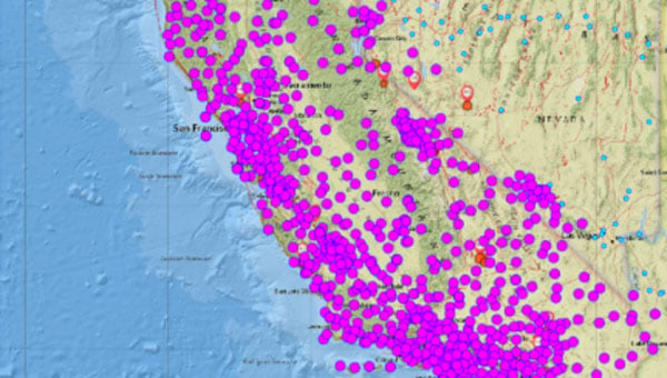
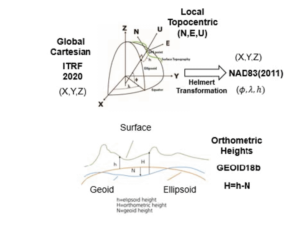
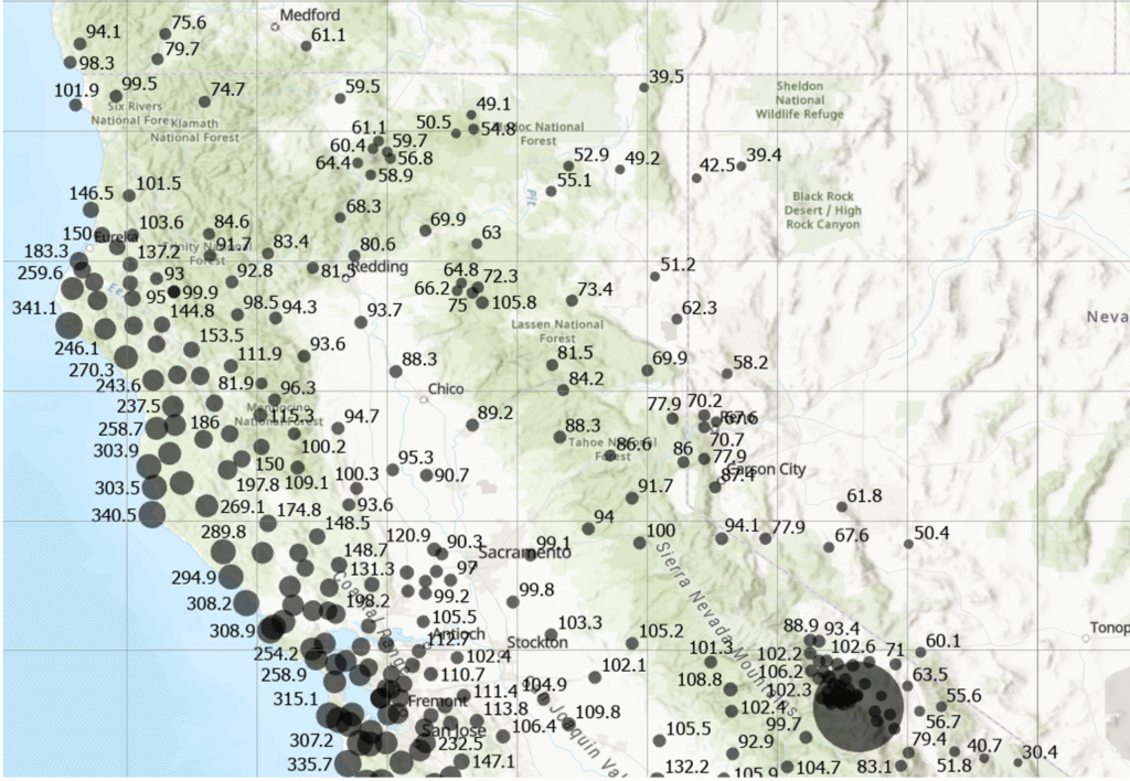
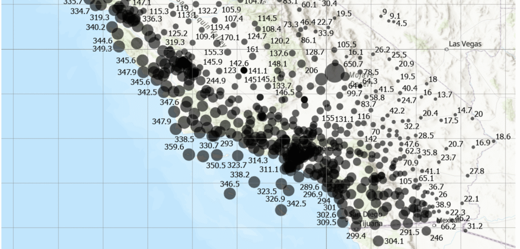
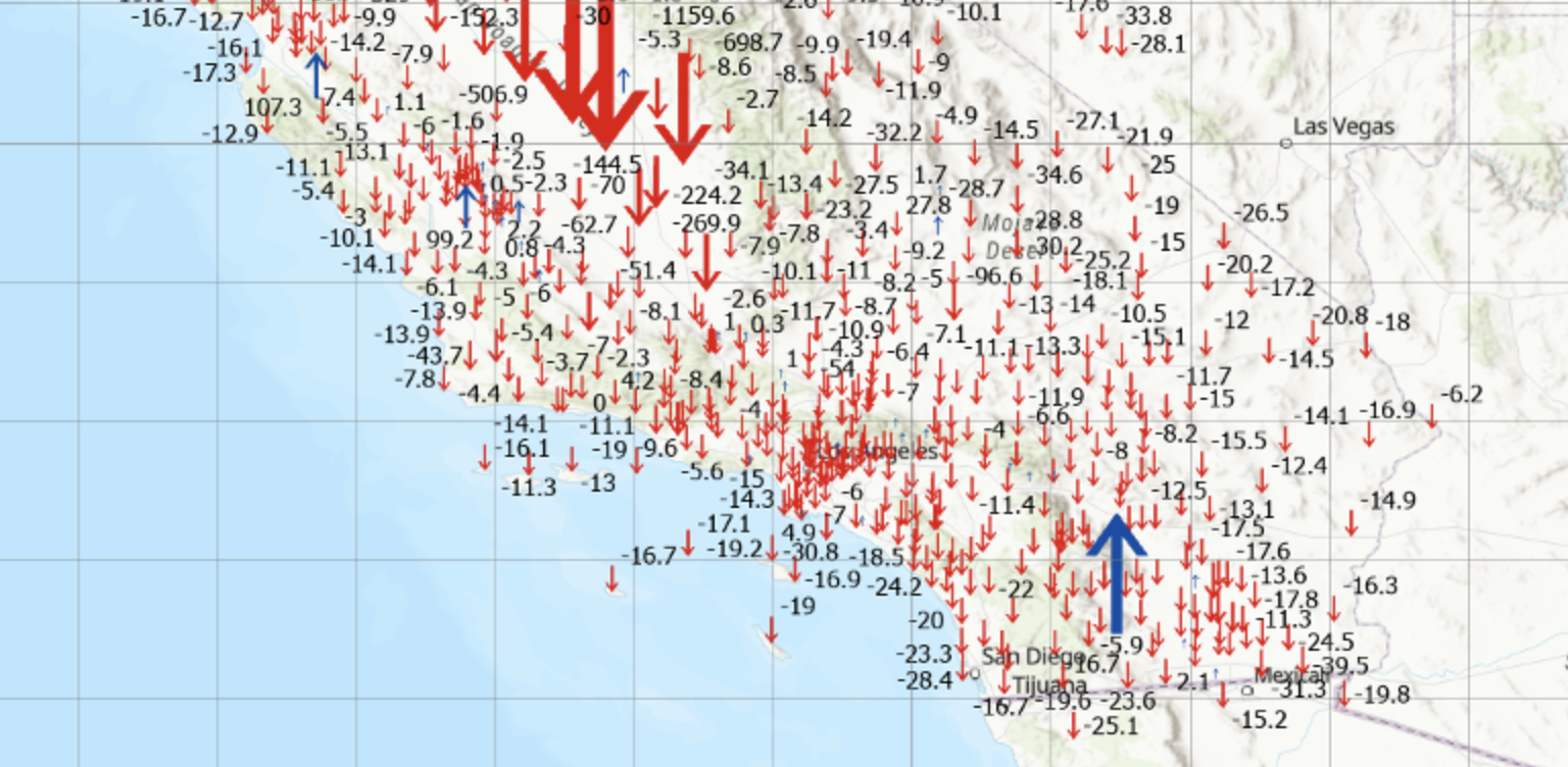
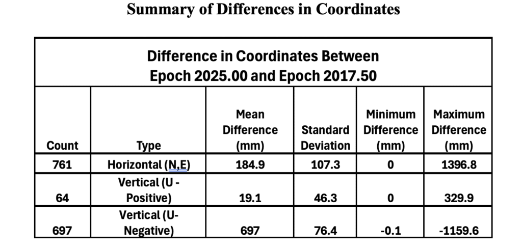
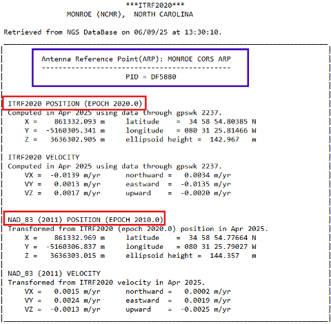
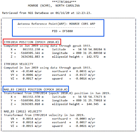
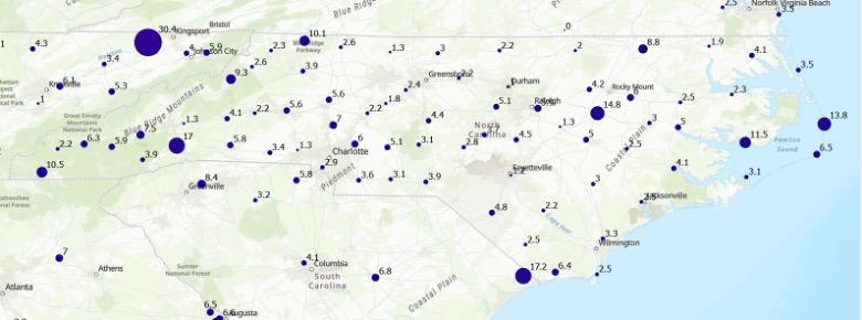
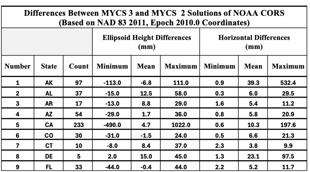
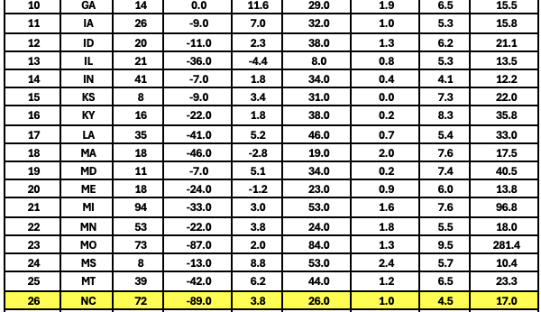
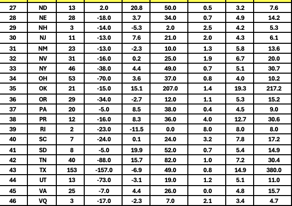
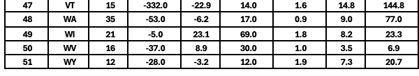
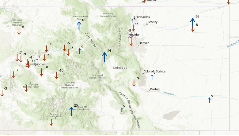
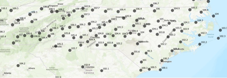
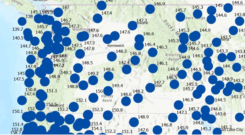
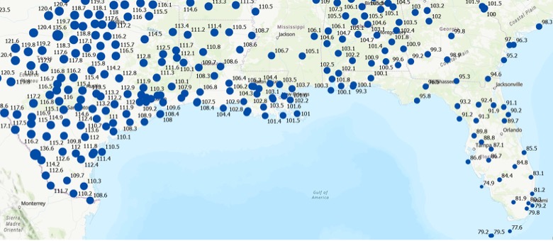
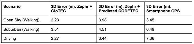
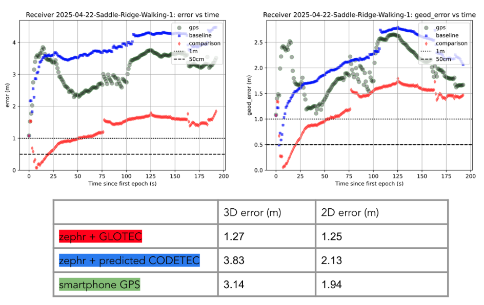
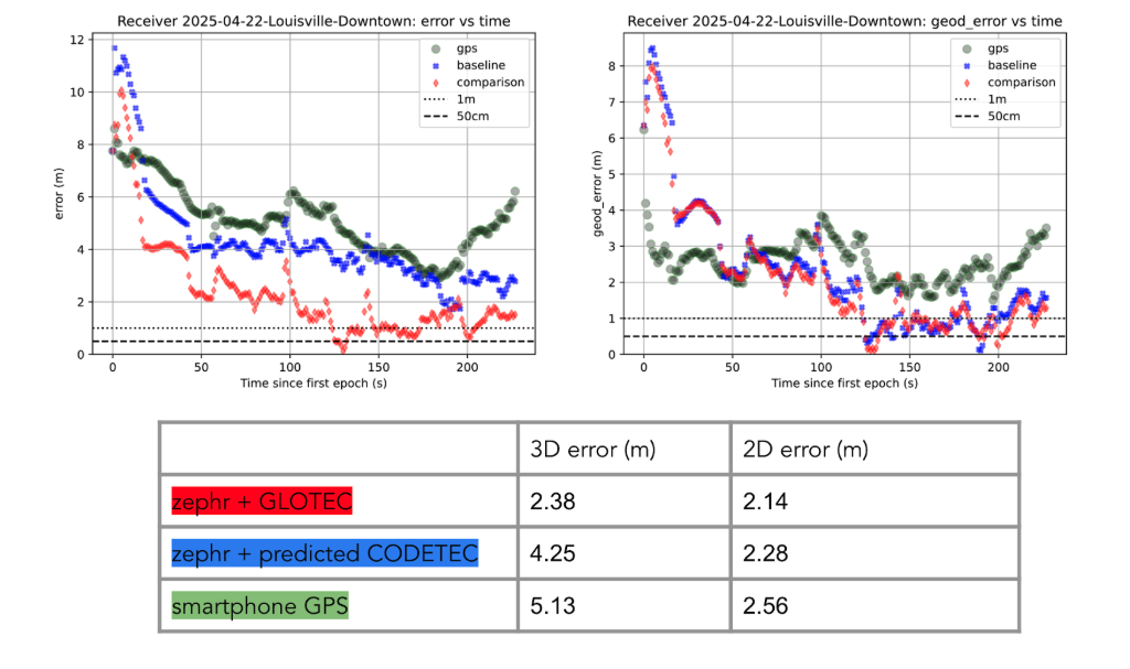
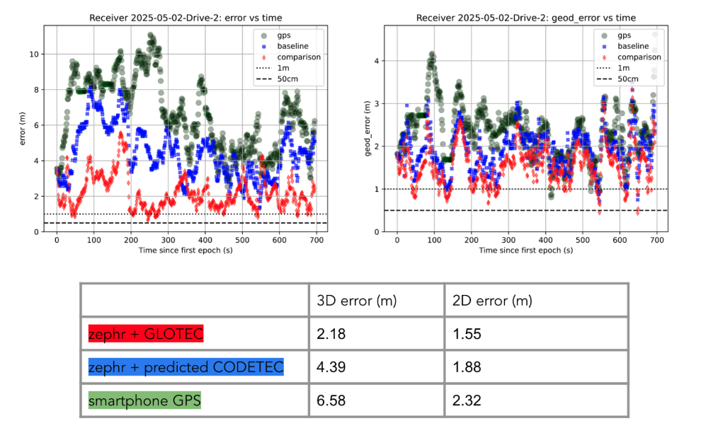
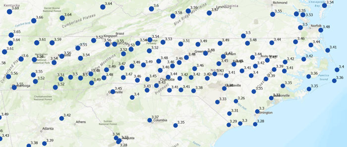
    Many participants of the North Carolina working group expressed interest in understanding how much the coordinates will shift with the new NSRS. While NGS’s website offers diagrams that provide a high-level overview of coordinate and product changes, many users sought more detailed information specific to North Carolina. To address this, I used NGS’s Multi-Year CORS Solution 3 (MYCS3) update of the NOAA CORS Network to ITRF2020, epoch 2020.0, to estimate the changes between the current NSRS — NAD 83 2011 (epoch 2010.0) — and the upcoming NSRS in North Carolina, such as NATRF2022 at epoch 2020.0. This approach offers a more detailed view of the magnitude of shifts in local regions. The figure titled “Approximate Differences Between NATRF2022 (Epoch 2020.0) and NAD 83 2011 (Epoch 2010.0) in NC” illustrates the approximate horizontal coordinate differences between the current NSRS and the future NSRS based on NCN CORS data. (Note that these units are in feet.) For additional information on MYCS3 and regional changes across the United States, refer to my August 2025 GPS World column.

    Approximate differences between NATRF2022 (Epoch 2020.0) and NAD 83 2011 (Epoch 2010.0) in North Carolina. Horizontal change in feet. (Credit: Dave Zilkoski)
    Approximate differences between NATRF2022 (Epoch 2020.0) and NAD 83 2011 (Epoch 2010.0) in North Carolina. Horizontal change in feet. (Credit: Dave Zilkoski)

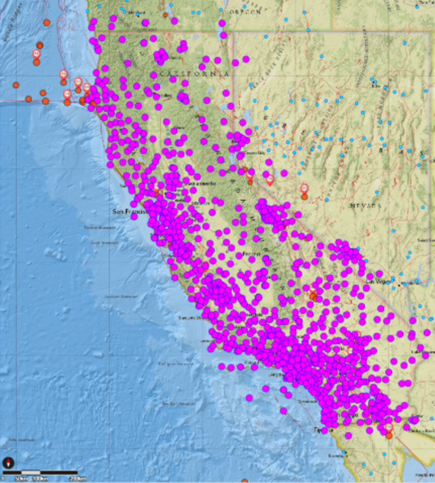
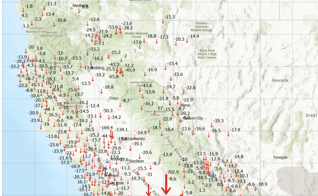
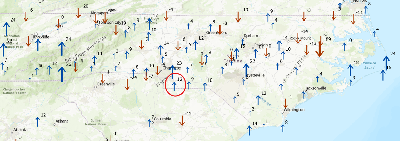
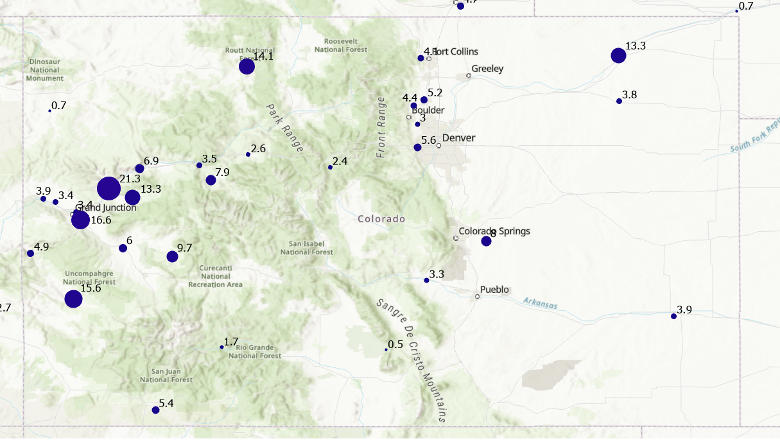
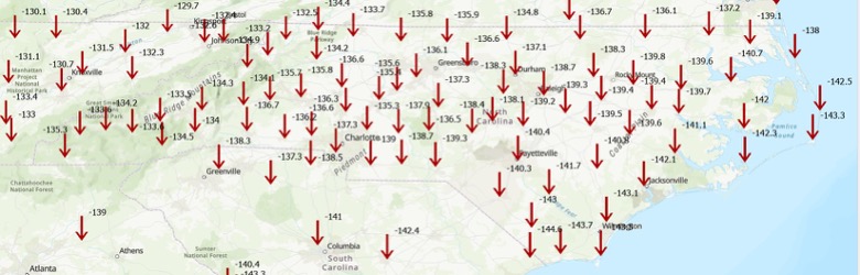
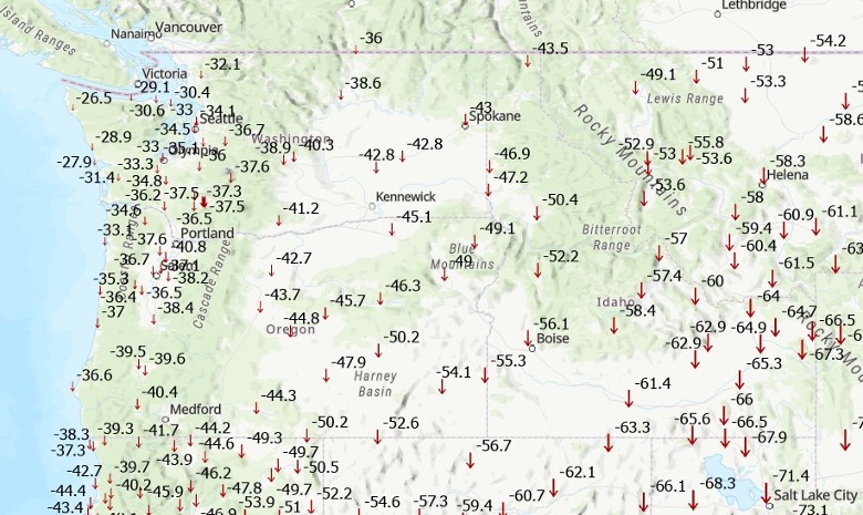
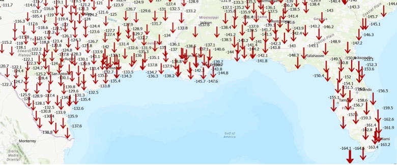
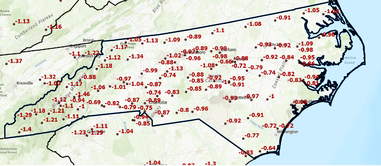
    Differences in orthometric heights between the new NAPGD2022 and the current NAVD 88 are significant for anyone working with FEMA flood maps or preparing flood insurance elevation certificates. I used ITRF2020, epoch 2020.0, ellipsoid heights from NOAA CORS stations along with Geoid2022 values to estimate the NAPGD2022 orthometric heights at the CORS sites. As depicted in the plot, the height differences between NAPGD2022 and NAVD 88 across North Carolina range from about 0.5 feet in the southeastern region to over a foot in the northern and western regions. (Note that the units are in feet.)

    Approximate differences between NAPGD2022 and NAVD 88 in North Carolina. Orthometric height change in feet. (Credit: Dave Zilkoski)
    Approximate differences between NAPGD2022 and NAVD 88 in North Carolina. Orthometric height change in feet. (Credit: Dave Zilkoski)

    This type of information should be shared with managers of real-time GNSS networks(RTN). RTN operators could then establish a parallel beta system to enable users to understand how the new NSRS may affect their products and services. (Note: The North Carolina Geodetic Survey, which manages the NC CORS/RTN system, is considering running a pilot parallel RTN based on the new NSRS.) This data can be valuable for RTN users to assess how coordinate changes might influence their workflows. For example, it can help determine how the shifts in coordinates will affect agricultural activities such as planting, fertilizing and harvesting. Will farmers need to remap their fields, or will a transformation be sufficient?

    Fostering collaboration with stakeholders and constituents will help users better understand how the NSRS modernization impacts their products and services. Developing strategies to align geospatial data management with regulatory requirements and operational objectives will also facilitate a smoother implementation process. NGS is partnering with federal agencies and professional societies to create a self-assessment guide that helps organizations evaluate how the NSRS update affects their geospatial missions. As previously mentioned, the North Carolina 2022 Reference Frame Working Group is working with state and local agencies, as well as surveyors, to proactively address key questions and challenges. This collaboration aims to improve communication with NGS and determine whether their products and services need to be reprocessed, re-surveyed or transformed to suit the new standards.

    Each organization has its own unique geospatial requirements and a thorough understanding of its mission and needs. This is an ideal opportunity to develop a centralized plan for evaluating and managing geospatial workflows during the transition to the modernized NSRS. Challenges include aligning legacy datasets with new reference standards while ensuring data integrity. Organizations should assess the accuracy of their data in relation to the NSRS and document any necessary updates in metadata. By creating a well-structured plan that balances operational constraints, legal compliance and practical considerations, organizations can prioritize accuracy, efficiency and alignment with the updated NSRS.

    To assist others in preparing for the new NSRS, Dana J. Caccamise II, NGS regional geodetic advisor, has developed guidance materials that have been shared with federal agencies — including the FGDC and their team leaders — and professional organizations such as NSPS, ASPRS and AAGS. See the boxes titled “Questions to Guide a Self-Assessment of Your Operation and Products” and “List of NGS Products and Services — Are your workflows dependent on one or more NGS products.” The goal is to help these agencies become ready to implement the new NSRS once it is officially adopted by NGS.

    Questions to Guide a Self-Assessment of Your Operation and Products
    Are you generating or using geospatial data (or doing both)?
    – If so, your workflows are likely dependent on geodetic control tied to one or more NGS products. The upcoming NSRS update will affect these dependencies. (See “List of NGS Products and Services.”)
    Do you know if your mission, project, or datasets depend on NGS products?
    – Identifying whether and how your entity relies on NGS products is a critical first step in assessing potential impacts.
    What are your accuracy, precision, and shelf-life requirements for geospatial data?
    – Understanding your mission’s specific data requirements ensures you can evaluate whether NSRS modernization will meet your operational needs without unnecessary adjustments. This should include plans to accommodate greater accuracy in the future.
    Do you know how your entity accesses and utilizes geospatial data?
    – Are you obtaining it directly from NGS or indirectly through third-party vendors (e.g., RTN systems, GIS platforms, GNSS companies)?
    – Have you considered how updates to NGS products may impact the tools or services you rely on from these vendors?
    – Many entities rely on geodetic control without realizing it. NGS’s foundational data and frameworks are often invisible and seamlessly embedded within the tools and services offered by third-party vendors, such as GIS platforms, survey equipment, and software providers. These vendors, in turn, depend heavily on NGS products like the NSRS to ensure their tools are accurate and functional. Understanding this indirect reliance is crucial for preparing your workflows and ensuring continuity as the NSRS is modernized.
    Where does your entity fit in with the geodetic workflow?
    – Does your entity create integral products (e.g., GNSS data, lidar data) on which other products depend?
    – Does it produce derivative products (e.g., DTM, Topographic Map, Flood Insurance Rate Map (FIRM) and Flood Insurance Study (FIS) Report)?
    – Evaluating these dependencies will help you determine the scope of NSRS modernization impacts.
    What are your project requirements for data accuracy and longevity?
    – Assess whether your data accuracy thresholds and long-term usability align with the modernized NSRS.
    Have you evaluated workflows and identified potential impacts in areas affected by significant ground movement (e.g., regions with tectonic shifts, vertical land motion, and, most notably, subsidence)
    – Identifying potential risk or disruption areas can guide prioritization and help mitigate impacts on critical operations.

    List of NGS Products and Services

    Are your workflows dependent on one or more NGS products

    Products and ServicesExamples
    Geodetic Control Data– Datasheets
    – State Plane CoordinatesSurvey
    – MarksSurvey Data
    National Spatial Reference System (NSRS) Datasets– Horizontal (Geometric) reference frames
    – Vertical (Orthometric / Physical) datums
    – Geoid Models
    NSRS Tools and ResourcesNGS Geodetic Tool Kit
    – NGS PC Software such as ADJUST
    – User-Contributed Software
    – VDatum to convert elevation data
    – Other NSRS Resources such as transformation tools
    GNSS Data and SolutionsOPUS (Online Positioning User Service)
    – CORS (Continuously Operating Reference Stations)
    – Satellite Orbits
    Gravity Data– Gravity for the Redefinition of the American Vertical Datum (GRAV-D)
    – Deflection of the Vertical (DoV)
    Coastal Mapping Products– Topobathy lidar Data
    – Shoreline Mapping Products
    Aerial Imagery and Remote Sensing– NOAA Remote Sensing Division Products such as Emergency response imagery (e.g., hurricane damage)
    Analytical tools– Least squares analysis tool
    – Antenna Calibrations
    GIS and Visualization Tools– Geospatial Data such as Shapefiles and KML files for GIS applications
    – Web Services
    Educational and Reference Materials– Documentation such as NGS technical reports
    – Presentations and Posters
    – User support such as NGS Information Center and Regional Geodetic advisors
    Historical Data Archives– Legacy Products such as Older geodetic survey records and Superseded geoid models and transformation tools
    Standards and Procedures, best practices, data formats– Standards and Procedures such as NOAA Technical Memorandum NOS NGS 92
    – Data Formats such as GVX (Real-time or post-processed GNSS vectors)

    To support the increased awareness of the modernization of the NSRS, under the auspices of the Federal Geodetic Control Subcommittee, NGS will host a meeting with federal geospatial agencies on Oct. 15, 2025, to discuss the NSRS modernization. The primary objectives of this meeting are to:

    • Increase awareness of the NSRS modernization rollout schedule and engagement strategy, including self-assessment and interaction between official departmental working groups.
    • Within other departments, connect decision-makers to those who accomplish NSRS modernization tasks and designate points of contact to interface with NGS capacity building efforts.
    • Share experiences and strategies among federal agencies concerning NSRS modernization self-assessment and preparation.
    • Gather questions, discuss anticipated challenges and identify opportunities to support each other through this transition.

    It is my understanding that this meeting is open to the public (virtually) for listening and observation. See below for more information on the meeting.


    Federal Geodetic Control Subcommittee Meeting

    • Date: Wednesday, October 15, 2025
    • Time: 1:00 PM – 4:00 PM ET
    Photo:

    I recommend that NSRS users consult guidance from NGS and engage with professional societies that have established working groups to analyze the impact of the new NSRS on geospatial products and services. Getting involved now will help ensure you are prepared when NGS officially adopts the updated NSRS. As Dru Smith, NGS NSRS modernization manager, explained in his webinar titled “NSRS Modernization — Big Steps Forward and What Comes Next” on Aug. 14, 2025, once the initial set of products and services of the modernized NSRS is “official,” the new NSRS becomes “The NSRS,” and its implementation then begins.

    Are you prepared to implement the new NSRS once NGS officially adopts it? Do you have the necessary tools and resources in place to support a smooth transition? This newsletter highlighted several actions that users can take now to ensure they are ready to implement the new NSRS when it becomes official.

  • Military drones advance as law enforcement seeks expanded counter-UAS mitigation authority

    Military drones advance as law enforcement seeks expanded counter-UAS mitigation authority

    General Atomics Aeronautical Systems Inc. (GA-ASI) is in the news again, as it got its prototype version of the U.S. Air Force (USAF) Collaborative Combat Aircraft (CCA) into the air for the first time, with an anticipated lengthy flight test campaign to follow. This latest CCA iteration, refered to as the YFQ-42A CCA, was derived from an earlier jet-powered XQ-67A Off-Board Sensing Station, a platform that enabled the company to not only develop and build but also fly this latest aircraft in just one year.

    GA-ASI CAA makes first flight Aug.t 27, 2025. (Credit: GA-ASI)
    GA-ASI CAA makes first flight Aug. 27, 2025. (Credit: GA-ASI)

    The UAV features significant autonomous capabilities developed over nearly five years of training using the MQ-20 Avenger unmanned jet aircraft. The strategy of beginning with a company-developed baseline aircraft (Avenger), securing USAF support for an initial derivative and then for the YFQ-42A CCA, appears to be accelerating development of the Loyal Wingman concept toward USAF operational manned-unmanned airborne teaming.

    Previously, in July, GA-ASI began preparations to enable friendly European countries to rapidly participate in the future CCA-capabilites by teaming with its German affiliate General Atomics Aerotec Systems GmbH (GA-ATS). The agreement appears to enable high-volume local manufacture of a European CCA, and press releases have implied that potential content is expected to be provided by other high-tech local suppliers.


    Following earlier reports that Reliable Robotics (RR) has been busy automating all phases of aircraft operations, including a Cessna Caravan cargo aircraft, USAF has awarded RR a $17.4 million contract to install a Reliable Autonomy System (RAS) in another Cessna. The resulting automated Cessna 208A Caravan is to be used in an estimated two-year program toward obtaining FAA certification that should enable flight within the U.S. National Airspace System (NAS). The system has been demonstrated — with a remote pilot in the loop — to be able to take an aircraft from startup on the ramp, through taxi, takeoff, en route flight, landing and taxi return to the ramp for unloading.

    RR autonomous Cessna 208B takes off from Mojave Air and Space Port, California, on Aug. 8, 2024. (Credit: RR))
    RR autonomous Cessna 208B takes off from Mojave Air and Space Port, California, on Aug. 8, 2024. (Credit: RR)

    Cessna Caravans have been heavily used for cargo transport across the U.S. (and around the world) with a range of 1000 miles, carrying up to 1000 lb of cargo. The RR certification program is intended to allow these types of automated unmanned commercial and military operations on a regular basis throughout FAA controlled US airspace, alongside manned aircraft. Flying military unmanned aircraft in the NAS currently requires extremely highly-coordinated, continuous activity. The hope is that eventually it could become an easier more regular form of autonomous cargo/people air transport.


    The cost of the continuing war in Ukraine may be affecting the Russian economy — a major drone manufacturer apparently is facing bankruptcy despite Russia currently using thousands of drones in attacks on Ukraine. The situation is difficult to understand, but this is an expensive war.

    However it appears that, AO Kronshtadt, one of the major drone suppliers in Russia is also beset by civil lawsuits from several organizations to which it owes lots of rubles. Its Orion and an updated version Inokhodets drone are apparently somewhat similar to the US MQ-9 Reaper UAV.

    AO Kronstadt employees assemble the Russian Orion UAV. (Credit: open source)
    AO Kronstadt employees assemble the Russian Orion UAV. (Credit: open source)

    Russia has apparently converted the Orion/Inkhodets medium-altitude surveillance drone into a strike version, but with limited success. Nevertheless, Kronshtadt apparently has made some progress, selling an export version in Asia.

    Meanwhile, Russia still is apparently producing up to 6,000 Shahed one-way drones per month by another manufacturer in the Alabuga Special Economic Zone at a unit cost of around $70,000. This is significantly lower than drones that were originally purchased from Iran at $370,000 each.

    Shahed suicide drone. (Credit: Olena Bartienieva / iStock / Getty Images Plus / Getty Images
    Shahed suicide drone. (Credit: Olena Bartienieva / iStock / Getty Images Plus / Getty Images)

    The U.S. Federal Government through its transport agencies apparently has the exclusive right to control drones, including bringing malicious UAVs down from the sky. Most people understand that the Federal Aviation Administration (FAA) regulates who flies what and where, but who is in charge of reducing and removing drone threats? It may have been difficult to understand during recent unauthorized overflights of military installations on the East Coast why someone didn’t shoot down the offending drones.

    Now, a group of police agencies has approached members of Congress to ask for the right to “detect, track, identify and mitigate” the unlawful, negligent or malicious use of drones that threaten public safety. Citing a number of incidents — including drone incursions at airports and other incidents where unmanned aircraft have interfered with firefighting and disaster response, instances where law enforcement activities have been overflown and disrupted, and the practice of using drones to drop drugs, guns and mobile phones into prisons — the law enforcement group sees a need for permission to engage. With several major events scheduled across the U.S., it likely is time to support law enforcement with the appropriate powers needed to protect the public.

    It is true that several bills are already pending before Congress to enable state, local, tribal and territorial law enforcement agencies to find, identify and possibly mitigate inappropriate drone activity, but the group is urging action now. And they clearly demonstrate the need to be able to stop drone activity when necessary — the federal government cannot cover the whole country all the time, so it makes more sense to adequately train law enforcement and to distribute authorized local mitigation activity whenever it is found to be necessary.


    So a mixed bag this month — progress for the U.S. Collaborative Combat Aircraft initiative, more steps toward automation for air cargo transport, problems for one Russian drone supplier while others increase volume and the United States seeks options for better defense against them, and U.S. law enforcement seeks the capability to help mitigate drone incursions where they are not wanted — plenty of different angles to consider around unmanned aerial vehicles.

  • The spatial AI revolution: Entering the age of intelligence

    The spatial AI revolution: Entering the age of intelligence

    The intriguing paradox about the information age is that it relies on semiconductor chips, which are fundamentally made from sand (silicon dioxide) — the most tangible and seemingly infinite resource on Earth. Yet, in 2023, the global digital storage capacity reached 110 zettabytes (110 followed by 21 zeros), which is a staggering figure; in fact, it is 15,000 times more than the number of grains of sand on Earth and it’s doubling every three years. The information age is suffering from excess information. Data is consuming the universe.

    The velocity and quantity of information are overloading the ability to process it. This causes data-driven decision-making systems to fail. The limiting factor is human cognitive capacity to select, prepare and process the data, plus the ability to analyze it for meaningful insights. It is reminiscent of the early days of the Corona satellites of the TALENT KEYHOLE (KH) mission series that began in the 1950s during the height of the Cold War.

    Understanding activities behind the Iron Curtain was critical for national security. The KH
    satellites were expensive to launch and had short life spans. They used rolls of wet film dropped from space and captured by specialized aircraft with hooks to catch the canisters in mid-air. The low-resolution images (3 m to 5 m per pixel) were processed manually in darkrooms. Teams of 100 specialists, using razor knives and scotch tape, meticulously pieced together image strips into massive mosaics spanning several square meters. Working around the clock, assembling the full image would take up to five days, with subsequent analysis requiring another week. In total, from catching the film canister to delivering a final intelligence report, it took 17 days — a testament to imagery intelligence in the industrial era, characterized by massive operations demanding significant time and manpower, but it was too expensive and unsustainable.

    Photo: PRESIDENT EISENHOWER awards Capt. Mitchell, USAF, C-119 pilot, the Distinguished Flying Cross for the first ever capture of
a film cartridge dropped from space, in a photo circa 1960. cia.gov/resources/csi/static/corona.pdf
    Photo: PRESIDENT EISENHOWER awards Capt. Mitchell, USAF, C-119 pilot, the Distinguished Flying Cross for the first ever capture of a film cartridge dropped from space, in a photo circa 1960. cia.gov/resources/csi/static/corona.pdf

    “We live in a world where there is more and more
    information, and less and less meaning.”

    — Jean Baudrillard,

    “Simulacra and Simulation,” 1994

    In 1976, the technological landscape shifted dramatically with the launch of the KH-11 satellite, which could transmit 15 cm resolution images digitally to ground stations and was capable of distinguishing objects as small as a dinner plate. The satellite dramatically compressed intelligence-gathering timelines. Processing and analysis time decreased from 17 days to mere hours. The first digital image was shown to President Carter. That first image is believed to be of ongoing tensions in the Middle East, but it symbolized more than the triumph of technology; it represented a fundamental shift marking the end of the industrial era and ushered in the information age.

    Advancements in imagery were paralleled by developments in mapping, driven by the need for accurate spatial referencing. Various technologies throughout the 1970s offered partial solutions, but a solution did not happen until 1981 when Esri introduced Arc/INFO, a breakthrough geographic information systems (GIS) software that could operate on minicomputers instead of huge mainframes. That formed the basis of modern spatial analysis and visualization technologies; coming together with digital imagery is what allowed the information age to overtake the industrial era.

    In 2025, a similar technological transformation currently is underway. As the amount of information overwhelms existing systems, artificial intelligence (AI) is emerging as the solution. The information age is transforming into the intelligence age, where big processing meets big data. Advanced algorithms, machine learning and large language models (LLM) can swiftly and efficiently handle vast amounts of information. So, with data being the new oil, AI is the refinery.

    The Esri Federal GIS Conference in February could have been promoted as the “Dawn of GeoAI” conference. The term Geo AI is a subset of Spatial AI, and it is in its infancy. Esri is incorporating AI into many of its applications. Companies at the expo were teasing Spatial AI solutions in their products and services.

    What is Spatial AI?

    When the transformative power of AI is combined with spatial information systems, magic happens. Value is created that did not exist before.

    Spatial intelligence is the ability to think, visualize and understand in three dimensions. It is one of the primary types of intelligence. Currently, Spatial AI is capable of interacting with analysts using natural language to build models and perform tasks. Similar to so much else happening with AI, its capabilities are increasing rapidly.

    Photo: A CORONA SATELLITE image of Moscow captured May 28, 1970, as part of the TALE…
    Photo: A CORONA SATELLITE image of Moscow captured May 28, 1970, as part of the TALE…

    With iterative learning, the AI repeats a task millions of times on various training data to perfect its abilities, running through different scenarios multiple times with different datasets while completing multiple tasks. The AI quickly learns and can eventually surpass humans. This makes AI a super tool.

    Combine that capability with AI’s ability to access and infer an entire compendium of knowledge on a subject. The AI is able to ingest text, images, audio and video in minutes, and then reason and understand them all within the context of the parameters provided. Through its own AI agents, it will automatically run functions to garner insights, and then communicate those results through data visualizations, text, audio and natural speech. Spatial AI is an evolved form of AI able to understand data in the context of space and time within the body of knowledge it can access. It will monitor everything in real time to identify anomalies and hidden patterns and provide deep insights. It doesn’t just solve the information overload dilemma for data-driven decision-making, but it enhances it far beyond expectations.

    The Coming World of AI Assistants

    The future is already here. Reality is approaching science fiction at warp speed. A person living 100 years ago would only be able to understand the world of today as magic; and likewise, the world 20 years from now will appear magic to us.

    Interfacing with a Spatial AI system is similar to the multi-dimensional world we already exist within. Flat screens, keyboard and mouse will be secondary tools behind natural language and natural gestures and immersive experiential environments. The Spatial AI- enabled world will blur the lines between what is virtual and what is real. Jobs, businesses and the economy already are transitioning. The most well capitalized businesses are investing in this new technology.

    One of the industries at the forefront is healthcare. Imagine you are a neurosurgeon. Your patient has a glioblastoma identified by the MRI/CT scans uploaded into the Spatial AI Medical Assistant called SAIMA (pronounced Sāmă; when speaking with the system, you call it “Sammi”). The MRI/CT scans show a 3D model of the patient’s brain, highlighting the glioblastoma in red. Placing the integrated augmented reality (AR) glasses on, you can zoom in on the glioblastoma to see the extent of the growth and view it from any angle. This helps formulate a surgery plan. The patient’s medical records are in SAIMA along with the corpus of knowledge about glioblastomas. SAIMA is regularly updated with the latest algorithms and models. After reviewing the preliminary data, you have SAIMA run the spatial analytics and all the applied functions on the data. It takes approximately 35 minutes to complete. During that time, you review the SAIMA updates and go to lunch. You receive a text message from SAIMA after it completes its processing, letting you know it is finished without encountering any issues. SAIMA works with a system called VisAR, which is a precision surgical navigation system. After returning to your office, you put on the VisAR glasses to begin the review. Sammi begins by showing you the glioblastoma and pointing out it is a large, heterogeneous mass located in the frontal lobe and appears to be 4 cm to 5 cm in diameter, in an irregular shape with nodular and cystic components. As it goes through the review, it zooms in and rotates the 3D image, highlighting the exact area being talked about. You interrupt Sammi during this review and ask if the patient has been experiencing motor function issues since the tumor is in the frontal lobe, and you continue to probe further in a natural conversational tone as you delve deeper into the analysis. The conversation between you and Sammi is recorded and added to the file.

    The review with Sammi takes several hours, during which a high-confidence surgery plan is developed that you will present to the multidisciplinary tumor board, who will further query SAIMA. This thorough process ensures the best results and further trains SAIMA about glioblastomas, which will be used for a post-surgery debrief and for insurance purposes. Following a successful board meeting, SAIMA proceeds to reserve the operating room, schedule the patient, and create a detailed surgery plan with specific duties and exact times for each member of the surgical team. This plan is then disseminated to all members of the surgical team and preoperative staff. A detailed surgical procedure file is generated, which serves as a navigation file, similar to Waze or Google Maps, providing step-by-step instructions to guide the surgery. This file will be loaded into ROSA (Robotized Surgical Assistant), a high-precision robotic surgeon.

    On the day of the surgery, you wear special Bluetooth gloves that are synced with the SAIMA/VisAR glasses and ROSA. In real-time, magnified between 15x and 40x, you observe ROSA surgically removing the cancerous tissue. Overseeing the process, you see a tumor that has spread beyond the original CT/MRI scan and zoom-in on the tumor, and you take control of ROSA to manually remove the tissue. The surgical system uses a “differential engine” concept to scale down the surgeon’s movements to match the magnification level of the procedure, allowing for precise and delicate tissue removal. This means that the surgeon’s natural movements are reduced to a smaller, more precise scale, enabling accurate and intricate procedures. For example, a 1 cm movement by the surgeon might be translated into a 0.1 mm movement of the robotic arm, allowing for high-precision work. The system is dependent upon a high-level of spatial intelligence to make those calculations in real-time.

    Afterward, you return the surgery back to the automated control of ROSA to follow the surgical procedure file plan. Throughout the fully immersive procedure, you speak with Sammi in a calm, natural language and responsive manner.

    The patient, a married middle-aged father of two, not only survives but thrives because of the accurate analysis of SAIMA and the precision of ROSA, with you overseeing the entire process. The Spatial AI-based surgical system allows you to do what you wanted to do as a neurosurgeon and save people’s lives.

    Nothing is Permanent Except Change

    Breakthrough innovations, such as the internet, have changed the world. Spatial AI is going to do the same. These technologically driven schisms are huge opportunities. One can only speculate how it will alter the future. Once a technology takes hold, and it becomes obvious there is no going back, its adoption will accelerate, and in those moments, careers make exponential leaps. Those in front of it will make substantial gains. Position yourself accordingly. Learn about Spatial AI and Geo AI. Carve out your own specialty, such as Spatial AI/AR (augmented reality), Spatial AI/VR (virtual reality), Spatial AI/XR (mixed reality), and Spatial AI/FMV (full motion video). The future is yours to imagine.


    Photo: William Tewelow
    Photo: William Tewelow

    WILLIAM TEWELOW is a designated Geographic Information Systems Professional. He has a master’s degree in Organizational Leadership with a focus on Performance Management, a bachelor’s degree in Intelligence Studies focused on geospatial intelligence, and an undergraduate degree in Geographic Information Technologies. William retired from the Federal Aviation Administration in 2025 after 16 years in various roles supporting geospatial information for aviation operations in the national airspace. He is a graduate of the management fellowship Program for Emerging Leaders where he served on special assignment to the Department of Transportation, leading a national strategic geospatial initiative under the authority of the White House Open Data Partnership.

  • California updates its spatial reference network

    California updates its spatial reference network

    The California Spatial Reference Center (CSRC) modernized the California Spatial Reference Network (CSRN) on July 31, 2025. The new California Spatial Reference Network is denoted as CSRN Epoch 2025.00. 

    These coordinates changes affect California geospatial users, but the transition process to the new epoch is something that others should understand to prepare for the new, modernized National Spatial Reference System (NSRS), which is expected to be adopted in 2026. As I mentioned in my August 2025 newsletter, NSRS users should proactively assess their geospatial data dependencies and evaluate how adoption of the new datum will affect workflows, datasets and operational decision‑making. 

    The California Spatial Reference System (CSRS) is the official geodetic datum in California, as published by the California Spatial Reference Center (CSRC) according to Public Resources Code (PRC) §§8850–8861. The image below depicts the CSRN. It is rigorously aligned to the current definition of the National Spatial Reference System (NSRS) through a set of coordinate transformations from ITRF2020 to NAD83(2011) as published by the NOAA/NOS National Geodetic Survey (NGS). The California Spatial Reference System (CSRS) is realized by the geodetic coordinates and uncertainties of the CSRN on the date of 2025.00 (January 1, 2025; GPS week 2347, day 3) of 1068 GNSS stations (881 active and 187 defunct stations) in California and at the borders of Arizona, Nevada, Oregon and Baja California. CSRN Epoch 2025.00 NAD83(2011) replaces the previous CSRS Epoch 2017.50 NAD83(2011).

    The latest hybrid geoid model GEOID18 published by NGS was used to compute Global Navigation Satellite System (GNSS)-derived orthometric heights (DCOH) on the North American Vertical Datum of 1988 (NAVD 88) datum in accordance with the California PRC §§8890-8902 (California Orthometric Heights).

    Plot of CSRN (Credit: SOPAC)
    Plot of CSRN (Credit: SOPAC)

    As previously mentioned, the new CSRC Epoch 2025.00 (NAD83 (2011) replaces the previously published CSRC Epoch 2017.5 NAD83 (2011). Readers can obtain the project report that provides technical information about the new realization at the following link: https://sopac-csrc.ucsd.edu/index.php/csrn-epoch-2025-00/ . The website provides web-links to the project report and a table of stations that includes information about the coordinates.  See the image captioned “Excerpt from CSRC Epoch 2025.00 Web Page” for the links to the reports and tables.  The CSRC Epoch 2025.00 realization is aligned with NAD83 2011, Epoch 2010.0.  See the image captioned “Excerpt from Project Report V2” for the summary from the report. I have highlighted some sections of the summary that I thought others would find of interest.

    Excerpt from CSRC Epoch 2025.00 web page.
    Excerpt from CSRC Epoch 2025.00 web page.

    Excerpt from Project Report V2

    Summary

    This report, prepared under California Department of Transportation (Caltrans) Contract No. 52A0157, Task Order 1, documents the modernization of the California Spatial Reference Network (CSRN) by the California Spatial Reference Center (CSRC). This updated realization aligns the CSRN with the North American Datum of 1983 (NAD83 2011, epoch 2010.00).

    The new reference frame, effective on January 1, 2025 (GPS Week 2347, Day 3), is called CSRN Epoch 2025.00 NAD83(2011), referred to for short as CSRN Epoch 2025.00. It replaces the previous adjustment at Epoch 2017.50 and remains a core component of the California Spatial Reference System (CSRS).

    The CSRN is defined by the geodetic coordinates and uncertainties (Table 1) of 1,068 continuous GNSS stations881 active and 187 inactive or decommissioned—located throughout California and bordering regions in Arizona, Nevada, Oregon, and Baja California, Mexico. As California’s official geodetic reference network under Public Resources Code (PRC) §§8850–8861, all Caltrans surveys using the California Coordinate System of 1983 (CCS83) must reference CSRN control stations or comply with CSRN specifications. The definition and use of CCS83 are governed by PRC §§8801–8819. This new realization is fundamentally tied to the International Terrestrial Reference Frame 2020 (ITRF2020) through the IGb20 coordinates adopted by International GNSS Service (IGS) Analysis Centers. All multi-year processing for this project was performed within this state-of-the-art global reference frame. Furthermore, the CSRN Epoch 2025.00 is rigorously aligned with the National Spatial Reference System (NSRS) maintained by the National Geodetic Survey (NGS). Epoch 2025.00 geodetic coordinates are transformed from ITRF2020 to NAD83(2011) using the NGS Horizontal Time-Dependent (HTDP) utility (Figure 1). The ITRF2020 coordinates (X,Y,Z) of the 1068 CSRN stations are transformed into geodetic coordinates (latitude, longitude and ellipsoidal height), using the GRS80 ellipsoidal parameters (semi-major axis, a = 6378137 m and inverse flattening, 1/f = 298.257 222 101).

    CSRC submitted to the European Petroleum Survey Group (EPSG) definitions for datums, transformations, and coordinate reference systems for Epoch 2025.00 to facilitate unique terminology with associated metadata.

    GPS data (phases and pseudoranges contained in RINEX data files) collected at the CSRN stations from June 10, 1992 to May 17, 2025, and about 300 global tracking stations of the IGS network were re-analyzed in the ITRF2020 reference frame. The complete set of RINEX data and metadata are accessible from the Scripps Orbit and Permanent Array Center data archive.

    The latest hybrid geoid model GEOID18 published by NGS is used to interpolate geoid heights for each of the CSRN stations as the basis of Global Navigation Satellite System (GNSS) derived California Orthometric Heights (DCOH) on the NAVD 88 datum in accordance with the California PRC §§8890-8902 (California Orthometric Heights).

    Figure 1. Reference frames for CSRN Epoch 2025.00 NAD83(2011).
    Figure 1. Reference frames for CSRN Epoch 2025.00 NAD83(2011).

    As provided in the summary of the report, a diagram noted that the ITRF 2020 cartesian (XYZ) coordinates were transformed into NAD83 (2011) cartesian (XYZ) coordinates, and then into local topocentric coordinates (NEU) to obtain the CSRC Epoch 2025.00 NAD83 (2011) coordinates. 

    I downloaded the table of stations with their various coordinates and plotted the differences between the new CSRC Epoch 2025.00 NAD83 (2011) and the previous CSRC Epoch 2017.50 (NAD83 (2011) for stations that were designed as operational stations in 2025.  The following plots depict the difference in coordinates between Epoch 2025.00 and Epoch 2017.50.  One can see that there’s a reason that California needs to periodically update the coordinates of the California Spatial Reference Network.  Some of the horizontal coordinates have changed over 300 mm or around one foot.  The vertical coordinate changes are not as large, but some do shift more than 4 cm.

    Note: The plots do not include newer stations with less than 6 months of solutions (no velocities estimated) and defunct stations (stations in Epoch 2017.50 but no data before January 1, 2025.

    Differences in horizontal coordinates (N, E) between Epoch2025.00 and Epoch 2017.50 northern section.
    Differences in horizontal coordinates (N, E) between Epoch2025.00 and Epoch 2017.50 (northern section).
    Differences in horizontal coordinates (N, E) between Epoch2025.00 and Epoch 2017.50 southern section.
    Differences in horizontal coordinates (N, E) between Epoch2025.00 and Epoch 2017.50 (southern section).
    Differences in vertical coordinates (U) between Epoch2025.00 and Epoch 2017.50 (northern section)
    Differences in vertical coordinates (U) between Epoch2025.00 and Epoch 2017.50 (northern section).
    Differences in Vertical Coordinates (U) between Epoch2025.00 and Epoch 2017.50 (southern section)
    Differences in Vertical Coordinates (U) between Epoch2025.00 and Epoch 2017.50 (southern section)

    The image below provides some statistics about the differences in coordinates between Epoch 2025.00 and Epoch 2017.50.

    Photo:
    Notes: (1) Only includes operational stations in 2025 (2) Does not include newer stations with less than 6 months of solutions (no velocities estimated). (3) Does not include defunct stations: in Epoch 2017.50 but no data before January 1, 2025.

    This newsletter highlighted that the CSRC has adopted a new Public Resources Code–compliant geodetic datum (reference frame) for California: CSRN Epoch 2025.00 NAD83(2011), which replaces CSRN Epoch 2017.50 NAD83(2011). The updated datum incorporates secular (linear) tectonic motions across the North America–Pacific plate boundary, transient motions (such as coseismic and postseismic deformation and fault creep), vertical land motion (subsidence and uplift), and data from new stations established since Epoch 2017.50. Additionally, the new vertical datum provides a comprehensive set of California Orthometric Heights on the NAVD88 datum for all CSRN stations.

    In essence, the CSRC has released three new datums. The first is tied to ITRF2020, the second to NAD83(2011), and the third to NAVD88. Transformation parameters are available between the first two datums. The NAD83(2011)-based datum satisfies California’s Public Resources Code requirements and is the recommended standard for geodetic control in the state. The NAVD88-based datum provides GNSS-derived California Orthometric Heights of 1988 (COH88).

    These new datums will be added to the European Petroleum Survey Group (EPSG) database, the worldwide standard for coordinate reference systems (CRSs) and transformations. Each will receive a unique EPSG code, making it easy to reference and use. This will ensure that CSRN Epoch 2025.00 NAD83(2011), CSRN Epoch 2025.00 (ITRF2020), and COH88 Epoch 2025.00 (NAVD88) can be seamlessly integrated into industry software.

    The CSRC report also noted that NGS has released a beta version of the modernized horizontal and vertical datums for the NSRS: NGS New Datums.

    Once the modernized NSRS is fully published, and in response to the needs of California’s user community, CSRC will continue working to secure resources that support its partnership with NGS and ensure ongoing compatibility with national programs.

  • New eVTOL and UAV platforms mark key advances in urban air mobility

    New eVTOL and UAV platforms mark key advances in urban air mobility

    As we are always looking for news on electric vertical take-off and landing vehicle (eVTOL) progress, the United Kingdom has recently stepped up with Gloucestershire-based Vertical Aerospace in the Cotswolds area, a beautiful part of Southwestern England.

    The company flew its new VX4 prototype from Cotsword airport to RAF Fairford (a military airport) for the Royal International Air Tattoo (RAIT), one of the world’s largest military airshows. This demonstration marked the first flight between two public airports in the country. The VX4 was also the only eVOTL on display at RAIT.

    RAF Fairford, which also serves as a base for the U.S. Air Force in Europe, has hosted aircraft including the U.S. B-52, B-1, B-2 bombers and U-2 reconnaissance aircraft. This year, RAIT featured several hundred aircraft from 30 countries, with around 200,000 attendees.

    The VX4 is equipped with eight tilt-and-lift propellers that provide redundancy for takeoff, landing and horizontal flight. The aircraft is designed to carry four passengers and one pilot.

    The avionics include proven Honeywell flight controls, and the lightweight airframe is constructed from carbon composite materials. Vertical Aeropspace said the eVTOL is designed to meet the same UK and European certification requirements as existing conventional passenger aircraft.

    The VX4 is designed with extremely low noise characteristics in both hover and horizontal flight at up to 150 mph. The company plans to use a hybrid-electric power unit in its production models.

    VX4 in flight.(Credit: Vertical Aerospace)
    VX4 in flight.(Credit: Vertical Aerospace)

    With a range of 100 miles and a max speed of 150mph, VX4 is being touted for short hops to overcome crowded city roads, or in London, avoiding changes on the underground while toting cumbersome luggage, and flying between downtown and one of London’s busiest airports.

    The VX4 can be reconfigured to carry cargo and is powered by specially designed batteries built for high output and rapid recharging, enabling quick turnaround for trans-city passenger transport.

    While aiming to replace helicopters for short hops over the city, Vertical Aerospace claims the VX4 offers far quieter, less maintenance-intensive and lower operating costs. There has been no mention of autonomous operations at this stage, but with all the necessary capabilities in hand, it’s possible that pilotless, automated flight could be possible at some future stage.


    Reliable Robotics (Reliable) has been around since being founded in 2017 – they have the objective of automating flight for General Aviation (GA), passenger airlines and cargo aircraft. Reliable reports that roughly 400 people are killed each year in GA through loss of flight and controlled flight into terrain accidents. Reliable believes that about 70% of issues could be prevented by their automation systems. For airlines, 1397 people died in 75 fatal accidents between 2017 and 2021.

    Working with the US Air Force (UASAF), FAA and NASA, Reliable first equipped and flew an unmanned Cessna 172 and later did the same with a Cessna 208B Caravan, similar to those operated by Federal Express (FedEx). In the process, they developed their own detect and avoid (DAA) system and qualified their own actuators to FAA standards. With the intention of developing a certifiable autopilot which would manage taxi, take-off, en-route flight, and landing, Reliable implemented a multiple flight management system which is supervised by a remote pilot.

    Unmanned Cessna 208B Caravan (Credit: Reliable)
    Unmanned Cessna 208B Caravan (Credit: Reliable)

    With the extensive use of simulations, around 140 landings were first accomplished and the third landing of the actual equipped aircraft was fully automated. It may have seemed a little unnerving at first to see the aircraft taxi out to the runway with no pilot in the cockpit!

    Nevertheless, it was clear that the system worked extremely well, with a remote voice interface, ground control, data link control, and monitoring of the aircraft system. With over 5000 airports available around the US, only 130 actually experience commercial operations, so the scope of enabling automated cargo transport activity more extensively across the nation appears to have room for expansion.

    Reliable has just begun more simulation work with NASA — automated aircraft human-in-the-loop detect and avoid (DAA); loss of the command and control (C2) link and the necessary reversionary recovery systems, and management of the automated aircraft alongside manned aircraft as they both enter and leave airports. Work is intended to figure out the level and type of automated systems required for safe integration of large volumes of cargo-carrying unmanned aircraft systems (UAS) into the National Airspace System (NAS).


    Northrop Grumman had Scaled Composites (SC) build a prototype (Model 437) manned UAV, which, according to the company, is now destined to become a testbed for autonomous systems development.

    Now called Beacon, the testbed originally flew in August 2024, possibly as a contender for the Loyal Wingman Collaborative Combat Aircraft opportunity, with a Pratt & Whitney 3400 lb thrust jet engine and an internal weapons bay capable of carrying 2000 lb of weapons. SC originally built the M437 as a platform to demonstrate Northrop’s digitally engineered wings.

    Model 437 in flight. (Photo: Scaled Composites)
    Model 437 in flight. (Photo: Scaled Composites)

    Now, Northrop is providing the airframe to enable collaborative partners to further develop autonomy capability to be used in future Northrop programs.

    Nice to see some VTOL air taxi development in the UK, an outfit focusing on the insides of UAV autonomy and even an aircraft platform for developers to use — all together interesting times for autonomous UAV growth.

  • Changes in OPUS products when the new NSRS is adopted: what does this mean to users?

    Changes in OPUS products when the new NSRS is adopted: what does this mean to users?

    On July 23, 2025, the National Geodetic Survey (NGS) sent a news notice announcing the rollout plan for remaining NSRS modernization products, including OPUS Products Changes, and on June 11, 2025, they sent a news notice to users stating that NGS’s Multi-Year CORS Solution 3 (MYCS3) was released. This newsletter will highlight these two News notices and what they mean to users of the United States National Spatial Reference System (NSRS).

    A colleague recently reminded me that the new NSRS is more than just a technical update — it presents an ideal opportunity to review existing processes and workflows, address current products and process considerations, and strategically plan for future requirements. It is well known that the new NSRS will significantly improve geospatial data accuracy. Improved accuracy and reliability of geospatial data empower management to make more informed decisions and optimize resource allocation. NSRS users should proactively assess their geospatial data dependencies and evaluate how adoption of the new datum will affect workflows, datasets and operational decision‑making. I will provide you with more information at a later date.


    NGS NEWS

    Rollout Plan for Remaining NSRS Modernization products, including OPUS Products Changes

    On June 17, 2025, NGS released the first preliminary products of the modernized National Spatial Reference System (NSRS) for beta testing and feedback. In the coming months, additional products listed below will be made available. As each product is released, it will undergo at least six months of testing preceding the final adoption and implementation of the modernized NSRS.

    The descriptions below supersede previous updates or information shared in NSRS Modernization blueprint documents, plans, or presentations. These products and their status will be described on the Track Our Progress webpage.

    1. The Data Delivery System (DDS) landing page will provide an updated version of the “NGS Map” and “Looking for Benchmarks” pages. This new landing page will allow you to access modernized informational pages about geodetic stations and geodetic marks.
    2. Geodetic station pages will offer an updated version of the current NOAA CORS Network (NCN) station pages. Geodetic mark pages will be updated datasheets, replacing the current ASCII text file version of datasheets. The updated coordinates (reference epoch coordinates) for marks and updated CORS coordinate functions (CCFs) for CORSs in the modernized NSRS will be available through these pages. 
    3. The NGS Coordinate Conversion and Transformation Tool (NCAT) will be updated through multiple versions, currently with state plane coordinates, then later adding support for various geopotential calculations including ellipsoid/orthometric height conversion as well as NADCON (geometric) and VERTCON (orthometric) transformations from the current NSRS to the modernized NSRS.
    4. OPUS-Static will function similarly to today’s tool, but it will operate with the modernized NSRS, including the support of multi-GNSS data. Additionally, the popular function of “sharing” your solution with others (colloquially called “OPUS-Share”) will be retained, but with appropriate caveats that the shared solution should not be used as geodetic control. These shared solutions will be available through the geodetic mark pages of the DDS.

    The following products will not be included in the release of the modernized NSRS. However, plans to replace the services or mitigate gaps are described below.

    • OPUS-Projects 5 will not be included in the modernized NSRS. Instead, NGS will focus on both developing an improved software suite for OPUS, known as OPUS 6, and minimizing any gap in service in which the current OPUS-Projects functionality is not available for users to organize, process, adjust, and submit high-accuracy GPS surveys for use by NGS in expanding and improving the NSRS. As noted above, OPUS-Share will remain available as a means to submit data to NGS.
    • OPUS-Rapid Static (OPUS-RS) will not be included in the modernized NSRS. Instead, the modernized version of OPUS-Static, noted above, will be capable of processing multi-GNSS static data files that are shorter in duration (i.e., less than 2 hours).

    Note: the current OPUS Projects 5 software will be supported until the modernized system is adopted, and a deadline for OPUS-Projects users to submit their surveys for publication will be announced with at least six months’ notice.

    To stay informed about these releases, please subscribe to NGS News. If you have questions, please email [email protected].


    Now, I would like to address the issues associated with July 23, 2025, announcement. This NGS News announced the rollout plan for the remaining NSRS modernization products. I have highlighted several sentences in this announcement that I believe users need to understand to determine the impact on their processes and workflows that are used to generate their products and services.

    The news announcement states that NGS released the first preliminary products of the modernized National Spatial Reference System (NSRS) for beta testing and feedback. My July 2025 GPS World Newsletter highlighted these preliminary products. It mentioned that in the coming months, additional products will be made available.  Each product will undergo at least six months of testing preceding the final adoption and implementation of the modernized NSRS. This seems to be a good process, but users need to understand the complete message.

    The NGS News announcement provides a list of products that will be available and a list of products that will not be available when the new NSRS is adopted. Users need to understand what products will not be available after NGS officially adopts the new NSRS so they can determine what that means to their workflow process and client requirements.  In my opinion, for the new NSRS to be successfully implemented by users, it is essential that all the necessary software tools are available to enable users to submit projects for review, approval, and publication by NGS.  As many of you know, when I worked for NGS, I was the Project Manager of the North American Vertical Datum of 1988 (NAVD 88). That said, from my experience as the NAVD 88 Project Manager, having the appropriate tools available was important for users to implement NAVD 88.  As a matter of fact, NGS accepted and processed vertical control data in both NGVD 29 and NAVD 88 for a period to assist users in the implementation of the new vertical reference datum.

    It is important to note that the NGS News Announcement states that OPUS-Project 5 will not be included in the new NSRS when it is officially adopted. See the below image.

    Credit: NGS

    Since OPUS Projects 5 will not be supported after the modernized system is adopted, users will not be able to submit their projects for review, approval, and publication by NGS like they can do today. NGS does indicate that they will be working on OPUS 6 to “minimize any gap in service.” There are a few questions that I believe should be addressed: (1) What does “minimize any gap in service” mean? Is this one month, one year, or several years?  (2) Why must the new NSRS be adopted before users can submit their projects to NGS for official publication? And (3) Why should users use OPUS-Share when NGS itself advises against relying on OPUS-Share results for establishing geodetic control?  If the federal agencies and surveying community allow the new NSRS to be adopted before OPUS 6 is available or OPUS Project 5 is modified for use in the new NSRS, the only way to get an updated coordinate such as NATRF2022 and NAPGD2022 using NGS process will be to use NGS OPUS-Share products. Again, NGS states that OPUS-Share results should not be used as geodetic control.  See NGS’ statement on OPUS Share below.


    This is NGS’s statement on OPUS-Share: Additionally, the popular function of “sharing” your solution with others (colloquially called “OPUS-Share”) will be retained, but with appropriate caveats that the shared solution should not be used as geodetic control. These shared solutions will be available through the geodetic mark pages of the DDS.


    Using OPUS-Share results that are NOT official NSRS coordinates published by NGS could lead to confusing results and potential lawsuits since NGS does not stand behind the results and recommends NOT using OPUS-Share results for geodetic control. Why would users use OPUS-Share to establish geodetic control when NGS itself advises against relying on OPUS-Share for establishing geodetic control?  OPUS-Share results are not officially submitted to NGS for review, approval, and publication on an NGS Datasheet. I don’t believe this approach will meet the needs of users who require their projects to be reviewed, approved, and published by NGS. What is your opinion? You should let NGS, and others know your thoughts and concerns about NGS’s rollout plan for remaining NSRS modernization products.

    Now for the release of NGS’s Multi-Year CORS Solution 3 (MYCS3).

    NGS MYCS 3 released. (Credit: NGS)
    NGS MYCS 3 released (Credit: NGS)

    First, why did NGS perform the NGS Multi-Year CORS Solution 3 (MYCS3)?  To maintain consistency with the International Earth Rotation and Reference System Service (IERS) and the International GNSS Service (IGS) reference frames, NGS has implemented the new International Terrestrial Reference Frame 2020 (ITRF2020) and IGS20 realizations in the U.S. NOAA CORS Network (NCN). What this means to NSRS users is that NGS has updated the North American Datum 1983 (NAD 83), epoch 2010.0 coordinates for stations in the NOAA CORS Network (NCN). This update is called the Multi-Year CORS Solution 3 (MYCS3).

    In summary, the MYCS3 news notice states the following:

    • The coordinate functions for NOAA CORS Network (NCN) stations are now consistent with ITRF2020,
    • NGS datasheets will display the new NAD 83 coordinates transformed from ITRF2020 coordinate functions,
    • The new NAD 83 coordinates will be referenced to NAD 83 2011 (epoch 2010.0),
    • Position and velocity files will display coordinates/velocities in both NAD 83 and ITRF2020, and
    • The NGS Online Positioning Users Service (OPUS) will begin processing data with NCN control that is consistent with ITRF2020 at the time of measurement; and the results will still be transformed to NAD 83 2011, epoch 2010.0.

    The first question that everyone asks is, what are the changes to the coordinates in my region? And, of course, why was it necessary to do this update now, but that’s a discussion for another day.  I downloaded the data and prepared a few plots and a table to depict the differences between the new and old coordinates.  First, it should be noted that the old NCN coordinates were published in ITRF 2014, epoch 2010.0, and the new NCN coordinates are published in ITRF 2020, epoch 2020.0. So, there will be differences in coordinates because of updates between ITRF2014 and ITRF2020, and because the CORS ITRF 2020 coordinates are published at epoch 2020.0 instead of 2010.0.

    The image below provides the new and old CORS coordinates and velocity information for NOAA CORS Monroe (NCMR). These values can be obtained from NGS CORS website.

    ITRF coordinates for NCMR.
    ITRF coordinates for NCMR. (Credit: NGS)

    The difference between ellipsoid heights is straightforward.  In the example, the difference is 144.357 meters minus 144.345 meters or 0.012 m. The image captioned “Change in Ellipsoid Height in NC based on ITRF 2020” provides the differences between MYCS3 and MYCS2 NAD83 2011, epoch 2010.0 published ellipsoid heights for the CORS in North Carolina.  In other words, this is the change in the NAD 83 2011, epoch 2010.0 ellipsoid height at the CORS after updating to ITRF2020, epoch 2020.  I’ve highlighted the NCMR CORS in the box. As you can see from the plot, there are several CORS in North Carolina that their ellipsoid heights have changed significantly; that is, greater than 20 mm and as large as -89 mm.

    Change in Ellipsoid Height in NC based on ITRF 2020 (units in mm)
    Change in Ellipsoid Height in NC based on ITRF 2020 (units in mm).

    I don’t know about you, but I can’t determine the change in coordinates by looking at XYZ or Latitude/Longitude values.  For the horizontal change I computed the differences in latitude and longitude and converted the results to millimeters. As indicated in the image above, the changes in the horizontal component are typically small; that is, less than a few mm.  There are, however, a few larger changes such as the one at CORS TN1B (which is in Tennessee) that changed 30 mm.

    Change in Horizontal Coordinates in NC based on ITRF 2020 (units mm).
    Change in Horizontal Coordinates in NC based on ITRF 2020 (units mm).

    I suppose for all “practical purposes” the changes are small and shouldn’t impact most survey projects.  Some of the larger changes are probably a good thing because that may mean that the CORS coordinates needed to be updated to account for movement or something else that affected the coordinates. I created a table that provides the minimum, mean, and maximum values in ellipsoid height and horizontal differences.  See the table titled “Differences Between MYCS 3 and MYCS  2 Solutions of NOAA CORS.”  I highlighted the State of North Carolina values.

    Photo:
    Photo:
    Photo:
    Photo:

    So, why is it important to understand these differences?  The NGS Online Positioning Users Service (OPUS) has begun processing data with NCN control that is consistent with ITRF2020 at the time of measurement.  This means that if you compare old projects to new projects, you may find some small differences due to the change in CORS NAD 83 2011, epoch 2010.0 coordinates.  As I previously mentioned, these differences are small and should not affect the results of most survey projects. Although, any difference can lead to someone questioning their results.

    As another example of the changes, the two plots below in the image captioned, “Change in CORS coordinates in Colorado based on ITRF 2020” provides the differences between MYCS3 and MYCS2 NAD83 2011, epoch 2010.0 published coordinates for the CORS in Colorado.

    Change in CORS coordinates in Colorado based on ITRF 2020
Ellipsoid Height Change (units in mm)
    Change in CORS coordinates in Colorado based on ITRF 2020 Ellipsoid Height Change (units in mm).
    Change in CORS Coordinates in Colorado based on ITRF 2020
Horizontal Change (units in mm)
    Change in CORS Coordinates in Colorado based on ITRF 2020 Horizontal Change (units in mm).

    Another difference that I computed using the results from the MYCS3 solution is an estimate of the changes between the current NSRS, that is NAD 83 2011 (epoch 2010.0) and new NSRS, for example NATRF2022, epoch 2020.0.   This is only an estimate but provides a value that users can attain the magnitude of the changes in their local region. The image below depicts the approximate changes in horizontal and vertical components between the current NSRS (NAD 83 2011, epoch 2010.0) and the future NSRS (NATRF2022, epoch 2020.0) based on the CORS in the NCN. (Note that the units have changed to cm.)

    Differences Between ITRF2020 and NAD 83 2011 in NC
Horizontal Change (units in cm)
    Differences between ITRF2020 and NAD 83 2011 in NC Horizontal Change (units in cm).
    Differences Between ITRF2020 and NAD 83 2011 in NC  Ellipsoid Height Change (units in cm)
    Differences between ITRF2020 and NAD 83 2011 in NC Ellipsoid Height Change (units in cm).

    To demonstrate that these changes vary region by region, I prepared plots depicting the changes in the State of Washington and the U.S. Gulf Coast region. As indicated in the plots, the differences between the current NSRS and the new modernized NSRS will vary from state to state and are significantly different than the current NSRS coordinates. 

    Differences Between ITRF2020 and NAD 83 2011 in Washington State
Horizontal Change (units  in cm)
    Differences between ITRF2020 and NAD 83 2011 in Washington State
    Horizontal Change (units in cm).
    Differences Between ITRF2020 and NAD 83 2011 in Washington State
Ellipsoid Height Change (units in cm)
    Differences between ITRF2020 and NAD 83 2011 in Washington State Ellipsoid Height Change (units in cm).
    Differences Between ITRF2020 and NAD 83 2011 in the Gulf Coast Region Horizontal Change (units in cm)
    Differences Between ITRF2020 and NAD 83 2011 in the Gulf Coast Region Horizontal Change (units in cm).
    Differences Between ITRF2020 and NAD 83 2011 in the Gulf Coast Region Ellipsoid Height Change ( units in cm).

    Differences Between ITRF2020 and NAD 83 2011 in the Gulf Coast Region Ellipsoid Height Change (units in cm).

    This newsletter underscored upcoming OPUS product changes that NGS will implement following adoption of the modernized NSRS, along with updates to CORS station coordinates resulting from the Multi‑Year CORS Solution 3 (MYCS3). It clarified what these changes mean for users of the U.S. NSRS. I also flagged several topics in the NGS News bulletins that warrant further attention, as they are critical for understanding how the modernized NSRS will impact geospatial products and services.  The new NSRS offers a strategic opportunity for users to comprehensively review existing processes and workflows, reassess current products, and proactively plan for future requirements. By auditing geospatial data dependencies now, NSRS users can evaluate how transitioning to the new datum will impact workflows, datasets, and operational decision-making.

    Will you be ready to implement the new NSRS after NGS officially adopts it?  Will you have the appropriate tools available to implement the new NSRS? These are questions that everyone that uses the NSRS should be addressing now.

  • Canada’s CSRS-PPP service sets a new standard for high-precision GNSS

    Canada’s CSRS-PPP service sets a new standard for high-precision GNSS

    Launched in 2003, Canada’s Precise Point Positioning (PPP) service, CSRS-PPP, continues to solidify its place as a world-class GNSS post-processing platform. Operated by the Canadian Geodetic Survey (CGS) under Natural Resources Canada (NRCan), the service enables users to obtain highly accurate coordinates from raw GNSS data without requiring proximity to a base station. Users simply upload RINEX observation files from either static or kinematic receivers, and CSRS-PPP returns positions referenced to NAD83(CSRS) or the International Terrestrial Reference Frame (ITRF). Crucially, this free and publicly accessible service is contributing enormously to the democratization of centimeter-level GNSS positioning for users around the world.

    Galileo PPP-AR Now Supported

    On May 14, 2025, CGS released a major upgrade to the service that introduced support for Galileo PPP with Ambiguity Resolution (PPP-AR). This new capability applies to Galileo E1/E5a signals recorded on or after November 27, 2022, and is available when using either Rapid or Final products. These “products” refer to high-precision satellite data; specifically, calculated information about satellite orbits, clock corrections, and signal biases, based on data collected by a global network of stations. The collected data are processed by NRCan and international partners to support CSRS- PPP’s precise positioning outputs. The recent CSRS-PPP upgrade builds on the PPP-AR support for GPS added in 2020 for data recorded on or after January 1, 2018, marking a significant step toward fully integrated, ambiguity-resolved positioning using data from multiple GNSS constellations.

    Why PPP-AR Matters

    The major milestone in October 2020, when ambiguity resolution was introduced to the CSRS-PPP platform, ushered in a new era of precision for users. At the core of PPP-AR is a significant shift in how satellite signals are interpreted. Traditional PPP estimates carrier-phase ambiguities as ‘float’ (real-valued) parameters because the integer number of whole carrier wavelengths between satellite and receiver remains unknown and unresolved. In contrast, PPP-AR resolves these ambiguities as fixed integers by utilizing precise satellite orbit and clock products alongside detailed modeling of satellite and receiver biases, thereby enabling reliable integer ambiguity resolution. This leap in algorithmic refinement leads to faster convergence times and enhanced accuracy, often down to the centimeter level. Ambiguity Resolution can lead to particularly noticeable improvements on east–west accuracy, which makes PPP-AR particularly valuable in applications demanding high horizontal precision.

    CSRS-PPP Advances: Broader Satellite Support and Richer Output Data

    Since its inception, CSRS-PPP has evolved steadily. Alongside expanded satellite constellation support, the platform’s reference frame has progressively advanced through updates from ITRF2005 to subsequent realizations, culminating in the adoption of ITRF2020. Additionally, CSRS-PPP output files now include valuable metrics such as estimated tropospheric delays, receiver clock offsets, and ambiguity resolution statistics. These enhancements provide users with more detailed insights into solution quality.

    Meeting Growing Demand

    Canada’s geodetic services continue to experience strong growth, with an increasing number of users relying on the CSRS-PPP service and related geodetic tools for essential positioning information. According to the Surveyor General Branch Annual Report for 2022–2023, file retrievals through CSRS-PPP and related tools increased by 45% in 2022 compared with 2021. Between 2022 and 2023, CGS supported over 11,000 active users and processed close to 1.3 million files across its suite of geodetic products and services.

    An Evolving Platform

    Even as this article was being written, on July 15, 2025, CSRS-PPP announced support for GPS signals C1L, L1L, C1X and L1X, further enhancing its capabilities and reaffirming its role at the core of a modern geodetic infrastructure. As GNSS shifts toward multi-frequency, multi-constellation services, CSRS-PPP is evolving in parallel, making centimeter-level accuracy accessible to a wider user base. With robust algorithms and enriched data outputs, CSRS-PPP remains a critical tool for high-precision positioning in Canada and a model for international GNSS services.

  • Capitol Hill event spotlights urgent need for GPS backup systems

    Capitol Hill event spotlights urgent need for GPS backup systems

    Government, industry and public safety leaders call for action on PNT resiliency as threats escalate.

    GPS is the invisible backbone of modern life, supporting America’s national and economic security in ways both recognized and overlooked. While other countries have developed competing systems, GPS remains far ahead of its rivals. Yet that dominance is also a vulnerability. GPS is a single point of failure, and the U.S. lacks complementary positioning, navigation and timing (PNT) solutions. A successful disruption could cost the U.S. economy $1.6 billion per day and impact everything from first responders to our energy grids.

    As threats to GPS reliability mount, policymakers and industry leaders gathered on Capitol Hill to underscore the urgent need for backup systems to protect America’s PNT infrastructure.

    Last month, I hosted an event on Capitol Hill called: “The Race to GPS Resiliency: What the US Can Do Today to Strengthen National Security.” It brought together senior officials from the Department of Defense (DOD), the Federal Communications Commission (FCC), Congress and industry to make the case for a layered approach to PNT resiliency. These experts examined the technical vulnerabilities of GPS, the increasing frequency of jamming and spoofing incidents, and the policy measures required to expedite the deployment of complementary technologies.

    GPS: Foundational and Fragile

    The first panel focused on how federal agencies are addressing growing vulnerabilities in GPS. Thomas Rondeau, Ph.D., principal director for FutureG at DOD, shared some eye-opening insights, including how a DARPA project demonstrated that, for less than $300 in parts from Amazon, one could “create a very bad day for the American military.” He called GPS disruption one of the easiest threats to develop and warned that adversaries are already exploiting this vulnerability as part of modern conflict.

    From left to right: Diego Areas Munhoz, Reporter, Punchbowl; Dr. Thomas Rondeau, Principal Director for FutureG, U.S. Department of Defense; Arpan Sura, Senior Counsel, Chief AI Officer, FCC.
    From left to right: Diego Areas Munhoz, reporter, Punchbowl; Thomas Rondeau, Ph.D., principal director for FutureG, DOD; Arpan Sura, senior counsel, chief AI officer, FCC.

    Rondeau shared how GPS disruption is now a feature of modern warfare, as he witnessed firsthand during his time at DARPA: “We were seeing massive loss of capabilities, and ordnance, because they were dependent on GPS. And as soon as they flew there, the tent turns on, capability goes away, we lose… assets.”

    Arpan Sura, senior counsel and chief AI officer at the FCC, walked through the FCC’s process for evaluating GPS alternatives and discussed how the agency is considering complementary PNT technologies.

    “National security is one of his (Chairman Carr’s) top priorities. And we recognize, as Tom mentioned, that GPS remains vulnerable to jamming and spoofing. But also, non-national security threats like solar flares, environmental risks like orbital debris. And there is heavy reliance on it in the U.S. economy,” Mr. Sura said.

    Lives on the Line

    From left to right: Mariam Sorond, Board Chair & CEO, NextNav; Adam Eldert, Director of Public Safety for Fairfax County, Virginia.
    From left to right: Mariam Sorond, board chair and CEO, NextNav; Adam Eldert, director of public safety for Fairfax County, Virginia.

    During the second panel, the conversation shifted from global conflict zones to local communities. Adam Eldert, director of public safety for Fairfax County, Virginia, emphasized the life-saving value of resilient PNT technologies in emergency response.

    “Technology should be carrying us forward, allowing us to make better decisions with the information we have to affect life-saving measures faster, get to places quicker and avoid any sort of potential problems,” said Eldert.

    Mariam Sorond, CEO and president of NextNav, pointed out that GPS limitations can delay locating 911 callers and responding to active threats like a mass shooting situation she and Eldert had previously discussed. “It’s not just to save somebody’s life, but it’s also about preventing disasters.”

    She then highlighted the company’s 5G-powered 3D terrestrial PNT solution, which is currently being considered by the FCC’s ongoing Notice of Inquiry on PNT and in a separate Petition for Rulemaking specific to NextNav. She explained that the company is working to address a national security challenge with a near-term, future-proof solution that delivers a widescale terrestrial PNT solution without relying on taxpayer funding.

    Congressional Support

    The closing panel featured Rep. Richard Hudson (R-NC), Chairman of the House Energy & Commerce Subcommittee on Communications and Technology, and former Rep. Greg Walden (R-OR), who previously chaired the full committee.

    Both Hudson and Walden warned that the United States is lagging behind adversaries such as China and Russia in deploying terrestrial backup systems to GPS.

    Chairman Hudson reflected on how the issue hits close to home: “I represent Fort Bragg, the largest army base in the world. We call it the epicenter of the universe. Our special forces and airborne troops that deploy out of Fort Bragg rely on GPS for almost everything they do. So, real-life scenarios with them keep me awake at night.”

    Chairman Walden spoke about another high-profile case in San Diego. “[T]here was a naval exercise between two ships, and they jammed GPS… which caused some issues, ” said Walden. “It also speaks to the problem we have, in America, where, unlike China and Russia, two of our adversaries, they have terrestrial-based systems for GPS backup.”

    What Comes Next

    The event made clear that action is needed — and possible. Mr. Sura told the crowd that he believes the FCC’s Notice of Inquiry will help drive a conversation about a holistic approach to PNT resiliency, exploring the economics of how these systems will work, and how to foster competition in a way that will yield multiple outcomes. When asked about next steps, Mr. Sura encouraged the group to “stay tuned.”

    Speakers throughout the event called for continued public-private collaboration to accelerate development of a more resilient PNT system — one that combines space-based and terrestrial technologies to safeguard national security, critical infrastructure, and public safety.

    Congressman Hudson closed with a note of urgency and optimism: “It’s clear the FCC understands the urgency, and they’re conducting thorough reviews right now.”

    Full event details and videos are available here.


    Diane Rinaldo of Peake Advisors, which sponsored the event, is one of the country’s leading authorities on 5G, telecommunications supply chain security and privacy. She served as Acting Administrator of the National Telecommunications and Information Administration and Acting Assistant Secretary of Commerce for Communications and Information in the first Trump Administration.

  • AI maps: The digital infrastructure driving  autonomous systems

    AI maps: The digital infrastructure driving autonomous systems

    Each day, millions of transportation decisions are made without a driver manually choosing a route or reacting to road signs. Trucks are rerouted around traffic hours before a jam appears. A vehicle slows down in a school zone, even without seeing a sign. A delivery service dynamically dispatches drivers based on weather and wait times.

    These are not just conveniences; they are outcomes of location intelligence working behind the scenes, powered by artificial intelligence (AI) and real-time mapping.

    At the heart of these systems lies a fundamental shift: maps are no longer static guides for humans. AI is unlocking a new era of computing and autonomous systems that will drive industry innovation and reinvention for years to come. Maps have become live, machine-readable software that enables automation at scale. Accenture’s Technology Vision 2025 report found large-language models (LLMs) are giving machines and robots more autonomy in the physical world, allowing them to better understand the physics of their environments, have spatial awareness, interact with people and understand complex instructions. This evolving autonomy is critical for autonomous vehicles, smart logistics and other systems that rely on real-time, AI-powered mapping to sense, decide and act.

    Whether it’s advanced driver assistance systems (ADAS), predictive logistics, EV range optimization or smart city operations, AI-powered mapping is fast becoming the connective tissue between sensing, decision-making, and action. It all begins with location data that is collected, interpreted and delivered in real time.

    From Navigation to Infrastructure: The Evolution of the Map

    Throughout the past two decades, digital maps have evolved from a novelty to a necessity. The early wave of turn-by-turn GPS tools was designed for humans — to get us from one point to another using the shortest or fastest route.

    Today, we are witnessing a new paradigm. As autonomy becomes embedded in vehicles, delivery operations, and mobile robotics, we need a new kind of map — one built for machines.

    These maps must be able to see, react and even predict. They must be continuously updated with real-time inputs, capable of interpreting events and structured in a way that allows for automation logic. In other words, they must be intelligent; and that intelligence comes from AI.

    AI-Powered Maps: What Makes Them Different?

    A live, AI-powered map is far more than a digital representation of roads and intersections. It begins with a foundational base layer — detailed information about road geometry, lanes, speed limits, signage and more. However, what sets these maps apart is how they evolve in real-time to reflect the dynamic nature of the world around us.

    They incorporate constantly changing inputs like traffic flow, construction activity, road closures and weather conditions — data streams that traditional static maps cannot accommodate. Beyond reacting to real-time events, AI maps also understand context. They may recognize nuances such as school zones that change by time of day, hazardous intersections, low-clearance bridges, and the availability or compatibility of EV chargers at nearby locations.

    Crucially, AI-powered maps don’t just describe what’s happening – they anticipate what might happen next. Fueled by billions of data points collected from vehicles, sensors, satellite imagery and crowdsourced sources, these systems use predictive modeling to foresee traffic build-ups, potential hazards or shifts in road accessibility.

    The result is a map that doesn’t merely guide but thinks — a constantly updating model of the world designed not for human eyes alone, but for machines that need to make decisions in real-time.

    AI fuses these elements, constantly recalculating and enriching the map to reflect what’s happening now and what might happen next.

    For this to work, mapping platforms must ingest the billions of data inputs. AI models then validate, filter and extract insight from this data — turning raw input into actionable intelligence and guidance.

    Why AI Maps Matter in the Vehicle

    Modern vehicles are increasingly defined by software, and that software needs a constant, reliable connection to the outside world.

    ADAS features, such as intelligent speed assistance (ISA), lane keeping and predictive cruise control, depend not only on sensors like cameras or radar, but also on high-quality map data to anticipate what’s ahead.

    For example, speed limit detection based solely on onboard vision can fail in poor weather or when signs are obscured. But when paired with verified, map-based data, continuously updated by AI, vehicles can make safer, more consistent decisions. As regulators in the EU and beyond mandate ISA systems in new vehicles, AI-enhanced maps are becoming a tool for regulatory compliance, not just convenience.

    As OEMs continue their shift toward software-defined vehicles (SDVs), they increasingly treat maps as a core software module, critical to the operation of the vehicle itself, not just a navigation layer.

    In the era of SDVs, maps are evolving into a foundational software service used not just to get somewhere, but to determine how and when it is safe to drive.

    How AI Maps Support the EV Transition

    One of the most significant barriers to widespread EV adoption is range anxiety: the fear that a driver won’t reach a charger in time, or that the charger will be in use or out of order. AI-powered maps help directly address this.

    By combining real-time charger availability, plug compatibility, dynamic traffic conditions, topography, and vehicle battery status, intelligent routing systems can not only suggest optimal charging points, but also reroute on the fly as conditions change.

    This level of intelligence is essential for EV fleet operators, especially those in logistics, ride-hailing or municipal transit.

    AI-powered maps also leverage charger usage patterns, traffic flows and gaps in the network to help cities plan where to place new charging infrastructure.

    In this way, location intelligence doesn’t just support EVs on the road but helps accelerate adoption.

    Why AI Maps Matter in the Supply Chain

    A HERE Technologies ‘On the Move’ survey found only 25% of transportation and logistics professionals are leveraging AI in supply chain management. Yet, the use cases for AI-powered mapping are plentiful.

    Fleet operators face daily challenges: delays, emissions targets, labor shortages and delivery windows that shift by the hour. They’re actively seeking technology-based solutions. McKinsey projects the autonomous heavy-duty trucking market could reach an aggregated $616 billion in 2035 in China, the United States and Europe.

    AI-powered maps help address many of these challenges. By combining real-time traffic information, road restrictions (e.g., weight limits, low bridges), and predictive analytics, intelligent maps help logistics operators optimize every mile.

    For example, dynamic routing can avoid areas of congestion hours before they peak, based on machine learning models trained on historical and live data. AI can prioritize delivery orders based on customer availability, time-of-day restrictions or weather disruptions.

    Beyond routing, maps also assist in asset tracking and risk management. Telematics systems that combine GNSS positioning with AI-based location intelligence can detect anomalies in driving behavior, flag out-of-route events and improve operational safety.

    The results are evident and tangible: lower fuel consumption, reduced delivery times and higher fleet utilization.

    GNSS and Geospatial Foundations

    It’s important to underscore that these intelligent maps still depend on foundational technologies like GNSS. Without reliable satellite-based positioning, none of these applications (ADAS, EV routing or predictive logistics) would be possible.

    But GNSS alone isn’t enough. Real-time location must be contextualized. An accurate lat/long fix is powerful, but the system needs to know: What road is that on? What’s the speed limit? Are there known hazards? What time of day is it? Is it raining?

    This is where geospatial data, fused with AI and layered into live maps, becomes transformational. The future isn’t about replacing GNSS — it’s about expanding what’s possible when GNSS is augmented with AI, context and prediction.

    Looking Ahead: Mapping as Mission-Critical Infrastructure

    As autonomy increases across industries — from fully autonomous vehicles to self-driving delivery trucks to smart city systems — AI-powered maps will underpin critical operations.

    AI-powered maps will be essential to the flow of goods, the safety of passengers and the predictability of city infrastructure. These systems must be continuously updated, machine-readable, context-aware, predictive and scalable. They also must be built with privacy, security and compatibility in mind. Governments, automotive manufacturers, technology providers and mapping platforms will need to collaborate — not just on data collection, but on standards, governance and interoperability.

    Quiet Engine of Autonomy

    We often focus on the visible outputs of automation: the driverless shuttle, the drone delivery, the smart traffic signal. However, none of these can function without a live map underneath, enabling every decision, in every moment.

    Digital maps have become the quiet engine of autonomy. With the power of AI, they’re becoming smarter, faster and more essential every day.

    For professionals in GNSS, geospatial intelligence, and positioning systems, this shift opens new territory where location isn’t just about where things are, but also about what’s happeningwhy it matters and what should happen next.

    In this world, AI-powered maps are no longer a tool. They’re infrastructure.

  • Helicopter and space UAVs pave the way for autonomous systems

    Helicopter and space UAVs pave the way for autonomous systems

    Alpha Unmanned Systems (Alpha) in Madrid, Spain, has been developing and building helicopter UAVs for 10 years and has successfully employed them with defense departments in 10 countries. Its UAVs are ruggedized and qualified for the harsh conditions encountered at sea. The fully autonomous A800 and more recent A900 model UAVs have been used in military applications such as border patrol, situation awareness, intelligence gathering, coast guard support and aerial helicopter target simulation. Commercial applications include fishing fleets and oil rig support.

    Alpha A900 approaches for deck landing. (Credit: Alpha)
    Alpha A900 approaches for deck landing. (Credit: Alpha)

    The helicopter UAVs are equipped with a GNSS/MEMS autopilot system that maintains navigation if GNSS is jammed. MEMS sensors, however, can experience significant drift over time. The Alpha model offers two additional backup solutions. With an advanced air data system and pitot sensors, the aircraft can estimate airspeed and wind velocity to help maintain its flight path. If attitude estimation degrades further, remote pilot judgment may be required to recover control. For ground operations, a visual navigation system with a downward-looking camera can record terrain during overflights, building a database that enables navigation in GNSS-denied environments.

    One of the newer capabilities Alpha has added includes an Automatic Identification System (AIS) receiver. AIS is a primary radar transponder system used by ships around the world to provide each other with tracking information on other ships that are within about a 30-mile range. With an AIS receiver onboard the UAS surveillance helicopter, ships that are out of visual range, maybe out close to the horizon, now become trackable.

    Alpha is a small company that has been in operation since 2014, and it is one of the first to design helicopter UAVs for rough weather and at-sea environments. It’s good to see a focused, supportive outfit gradually succeed, not only with European defense organizations, but also in the U.S. and around the world.


    Meanwhile, in a universe that’s not far, far away — in fact, in our solar system — plans are moving forward at NASA to visit Titan with a UAV. Titan is a moon of Saturn that is most favored to have the capability to start, and maybe support, life. Numerous organic compounds have been detected during earlier satellite visits. But this is no ordinary UAV, quite unlike Ingenuity, the solar-powered hopper that NASA flew 72 times on Mars.

    Ingenuity, a UAV that flew 72 times on Mars. (Credit: NASA)
    Ingenuity, a UAV that flew 72 times on Mars. (Credit: NASA)

    NASA’s Ingenuity helicopter, which traveled to Mars attached to the Perseverance rover, was designed to demonstrate powered flight in the Red Planet’s thin atmosphere. Ingenuity featured oversized rotor blades to generate enough lift and was built to be as lightweight as possible. Its only equipment was a camera and speed sensors, with no scientific instruments aboard.

    The helicopter performed flights over Jezero Crater, ultimately spending about 130 minutes aloft and covering 11 miles during 72 flights. Ingenuity’s mission came to an end after it sustained damage to a rotor during a hard landing, grounding the aircraft and concluding its operations on Mars.

    The next interplanetary unmanned flying system is significantly more complex, replacing the lander and drone approach used on the Red Planet with a complete vehicle capable of flying and conducting the necessary investigative science. With a budget of $3.35 billion, NASA’s work has been underway since 2024, led by John Hopkins Applied Physics Lab, and a host of main and supporting organizations, including Lockheed Martin Space, Malin Space Science Systems (cameras), Honeybee Robotics (Blue Origin subsidiary, moon lander development) and participation by agencies in France, Germany and Japan. While Ingenuity was developed and built by UAV manufacturer AeroVironment with management/support from NASA/Jet Propulsion Labs (JPL), the team for Dragonfly appears to have a few industrial partners and extensive government support – hopefully, this works out!

    Powered by a Radioisotope Thermoelectric Generator (RTG), Dragonfly has four sets of double rotors, landing skids, and, of course, has to be fully autonomous – the radio transit time between Titan and Earth is between 1 hour 10 minutes and 1 hour 40 minutes. Titan’s night is eight Earth days long, so the idea is to fly during the day (throughout 15 Earth days), then land and recharge batteries, and receive NASA’s instructions for the following day’s activities during the long night. The atmosphere is thought to be substantially composed of nitrogen and methane, four times thicker than Earth’s, and gravity is about 1/7, so 4 ft props with enough lift and power could carry the 880 lb to 990 lb UAV up to 10 miles for each flight at altitudes of up to 12,000 ft. But when observing and imaging the terrain, we might guess it would probably mean mostly low-level flights.

    Dragonfly Titan UAV explorer (Credit: NASA/Johns Hopkins APL/Steve Gribben)
    Dragonfly Titan UAV explorer (Credit: NASA/Johns Hopkins APL/Steve Gribben)

    At this weight, we are looking at something quite substantial to be flying around the anticipated sand dunes and frozen methane surface of Titan. Autonomous operations will need to be tight and safe for this big vehicle to operate and survive; it’s not exactly a small car, but quite substantial. Not to mention that landing will need to be somewhat delicate to protect the sensitive onboard instrumentation. 

    A spacecraft is scheduled to launch aboard a SpaceX Falcon Heavy in 2028, embarking on a complex journey that includes a flyby of Venus and a gravity-assist maneuver past Earth to set a direct course for Saturn’s moon Titan. The probe is set to enter Titan’s dense atmosphere directly, protected by a heat shield. After initial deceleration from atmospheric drag, two drogue parachutes will deploy, followed by a powered descent to the equatorial region known as the Shangri-La dune fields.

    The voyage is expected to take six years, with arrival at Titan in 2038. Once on the surface, the Dragonfly mission will begin a 2.7-year exploration of the moon.


    An interesting initial glimpse into a future, really advanced drone are undertaking. Hopefully, NASA will keep to its schedule, the budget holds up, and we start to see hardware in the next few years. Meanwhile, Alpha could be on version 16 of its UAV helicopter by then and achieve massive success with its multi-mission UAV applications.

  • Nowcasting the ionosphere: Evaluating GloTEC for real-time GNSS corrections

    Nowcasting the ionosphere: Evaluating GloTEC for real-time GNSS corrections

    One of the most persistent sources of GNSS error — ionospheric delay — has been challenging to correct in real time, especially for mass-market devices. While dual-frequency receivers and commercial correction services can mostly mitigate this issue, they remain too costly and impractical for the billions of smartphones and IoT devices that rely on single-frequency GNSS. Even for dual-frequency systems, the commonly used ionosphere-free linear combination amplifies multipath and receiver errors and reduces data redundancy — yielding only two usable combinations from four original measurements.

    This landscape may be shifting with the introduction of GloTEC, a real-time global Total Electron Content (TEC) map from NOAA’s Space Weather Prediction Center (SWPC), released in February 2025. GloTEC assimilates both ground- and space-based observations to provide real-time global ionospheric corrections without relying on error-prone linear combinations.

    Unlike coarse models such as the broadcast Klobuchar algorithm or forecast-only products such as the predicted IGS Global Ionosphere Maps, GloTEC updates every 10 minutes using real-time measurements. This high refresh rate establishes a new benchmark for open-access ionospheric nowcasting in GNSS applications.

    Originally designed to monitor and mitigate space weather impacts on aviation and communications, GloTEC may also deliver a broader benefit: enabling precise, scalable GNSS corrections for low-cost, single-frequency devices, making high-accuracy positioning more accessible and democratic.

    Why Nowcasting Matters for GNSS

    The GNSS community has long had to choose between accuracy and latency. Predictive models, such as those from NASA CEDIS or CODETEC, can offer reasonable approximations but may fall short when real-time corrections are required, particularly in the context of navigation, asset tracking or autonomous systems.

    Post-processed products (such as rapid/final IGS GIMs) provide excellent fidelity but are typically delayed by hours, days, or even weeks. This makes them useful for research or auditing, but not for real-time navigation needs.

    Commercial correction services, such as Trimble RTX and Hexagon’s TerraStar, have filled the gap for high-value applications. These systems interpolate ionospheric corrections in real time, but at a significant cost and they typically require specialized GNSS receivers.

    GloTEC bridges this gap by delivering a publicly accessible, high-refresh ionospheric product that can support near real-time corrections. Updated every 10 minutes with a 2.5° latitude and 5° longitude spatial resolution, GloTEC represents a major step forward for public sector GNSS capability, particularly in contexts where accuracy, reliability and scale are all crucial. The data has also been supporting the United States Space Force and is accessible through their Unified Data Library (UDL).

    Technical Approach: Adapting GloTEC for Practical Use

    While the potential of GloTEC is exciting, turning it into usable corrections for consumer-grade devices isn’t straightforward. TEC maps represent volumetric electron density, while most mass-market GNSS chipsets, especially in smartphones, expect simplified models, such as the eight-parameter Klobuchar model broadcast by GPS satellites. GloTEC is a three-dimensional data assimilation system that uses a Gauss-Markov Kalman Filter to estimate electron density in the ionosphere. It ingests slant TEC measurements from ground-based GNSS receivers and space-based radio occultation data, using the IRI-2016 model as its background state.

    To bridge this mismatch, Zephr’s team has been exploring regional fitting techniques, whereby a local subset of GloTEC data is used to generate custom Klobuchar coefficients. These can be transmitted to devices via standardized protocols, such as the LTE Positioning Protocol (LPP), enabling improved ionospheric delay estimation with minimal changes to device-side computation. Even with a regionalized Klobuchar fit and LPP encoding, there is still the problem of accessing the GNSS chip to apply the corrections. To solve this problem, Zephr has created a virtualized positioning engine that takes the raw GNSS measurements from the chip and provides a purely software-based solver. This approach allows the team to implement a variety of more advanced positioning techniques using commodity hardware such as smartphones.  

    Field Testing: A Quantitative Step Forward

    To evaluate the efficacy of GloTEC in improving GNSS accuracy, engineers at Zephr used the virtualized positioning engine to conduct 51 real-world campaigns across various conditions – including urban, suburban, static, walking, and driving – using a Pixel 8 smartphone and an RTK unit for ground truth.

    The results were promising, as shown in Figure 1:

    Figure 1: GloTEC vs. CODETEC vs. Android Native across multiple scenarios. (All figures provided by author)
    Figure 1: GloTEC vs. CODETEC vs. Android Native across multiple scenarios. (All figures provided by author)


    We can break down these results using detailed graphs for each scenario as examples. This will provide a more in-depth look at the positioning for specific traces through the outlined scenarios in Figure 2, Figure 3 and Figure 4:

    Figure 2: GloTEC vs. CODETEC vs. Android Native for an open sky walking scenario
    Figure 2: GloTEC vs. CODETEC vs. Android Native for an open sky walking scenario
    Figure 3: GloTEC vs. CODETEC vs. Android Native for a suburban downtown walking scenario.
    Figure 3: GloTEC vs. CODETEC vs. Android Native for a suburban downtown walking scenario.
    Figure 4: GloTEC vs. CODETEC vs. Android Native for a mixed sky driving test.
    Figure 4: GloTEC vs. CODETEC vs. Android Native for a mixed sky driving test.

    Across all categories, the GloTEC-based regional fitting approach significantly outperformed both the default GNSS solution (which uses broadcast data plus a Klobuchar mode) and the competing IGS products. Accuracy improved by up to 69% in driving scenarios and 46% in walking scenarios, compared to standard smartphone GPS.

    While the Pixel 8 used in testing supports dual-frequency GNSS, smartphones face several practical limitations that hinder effective use of ionosphere-free dual-frequency combinations. These include limited signal availability (due to antenna constraints, L1/L5 support gaps, and partial constellation coverage), elevated multipath and noise (especially from omnidirectional antennas in dynamic conditions), and unstable clock biases that complicate error modeling. In fact, iono-free combinations can amplify multipath effects, potentially degrading accuracy in some conditions.

    Despite these constraints, the results show that meaningful improvements in positioning are possible using a software-based approach with publicly available corrections. GloTEC, when paired with cooperative or cloud-based GNSS engines, offers a substantial step forward without requiring expensive commercial correction services or specialized hardware.

    Broader Implications and Next Steps

    While these results are promising, several challenges remain before GloTEC-based corrections can be broadly deployed:

    • Connectivity Requirements: Real-time access to GloTEC requires periodic downloads over cellular or Wi-Fi connections, raising questions about reliability in low-bandwidth or disconnected environments.
    • Global Calibration: The accuracy of regional fitting depends on local coverage density and VTEC variability. Further tuning may be needed in equatorial or polar regions, where ionospheric behavior is more volatile.

    Nevertheless, the availability of GloTEC marks a significant milestone. For the first time, a free, real-time, high-resolution ionospheric correction product is accessible to developers, researchers, and engineers seeking to improve GNSS accuracy at scale. NOAA SWPC has plans to integrate more low-latency space-based and ground-based data into GloTEC in the near future. The new version of the model outputs will be released to the public once the results are validated. As techniques for applying it to mobile and IoT devices mature, the GNSS community may see a broad shift toward more precise, resilient, and cost-effective positioning systems.

    GloTEC may have been designed to help forecasters monitor the response of the ionosphere due to space weather events, but its potential to provide an advanced tool for positioning on Earth is just beginning to be understood. In a world where nearly every mobile application depends on location, and where the cost of poor accuracy is rising (from package delivery failures to navigation errors), this kind of public infrastructure is invaluable.

    Researchers and industry developers alike should explore how this NOAA capability can be integrated into their positioning systems. If properly supported, GloTEC could become one of the most impactful GNSS innovations of the decade.

  • When GPS is under attack, we need back-ups

    When GPS is under attack, we need back-ups

    On June 13, following reports of Israeli airstrikes on Iran, interference rates in the Strait of Hormuz spiked. GPSJam.org, a service that tracks satellite signal interference, now reports medium-level disruption (between 2% and 10%) across the Gulf region. This is no isolated blip, but part of a pattern: electronic warfare is increasing in global hotspots. It’s also a warning.

    Modern warfare is no longer about guns and bombs. Jamming, spoofing and using ever-more sophisticated cybertricks to disrupt GNSS are now regular tactics used to sow disorder. They are cheap, deniable, and often highly effective. But they also expose a dangerous weakness in how we navigate, communicate, and coordinate. If GPS is the backbone of global positioning, we are learning just how brittle it can be.

    Strait of Hormuz Under Threat

    The Strait of Hormuz is a narrow channel through which around one-fifth of the world’s oil passes, and here, ships are now at risk not only from pirates and mines, but from corrupted satellite signals. Spoofers can broadcast false GPS positions to nearby vessels. In recent years, we have seen ships appear to sail across runways, airports, and deserts, thanks to malicious signal interference. In aviation, spoofed or jammed GNSS signals have led to aircraft turning around mid-air or being diverted. These are real and growing threats.

    As someone who has worked in naval intelligence and the defense industry for decades, I have seen how quickly technology evolves, and how slow we can be to protect our own systems. But there are solutions to the problem I’ve described. One is laser-based optical communications.

    The Need for Resilient PNT

    Laser communication is very difficult to jam or spoof. Unlike the low-power radio frequencies used by GPS, a laser beam is narrow, focused, and nearly impossible to intercept without being detected. And because lasercom is optical, not radio, it isn’t vulnerable to the same types of interference. That makes laser communication ideal for high-security communications and low latency support in contested environments.

    Optical ground station networks, when paired with optical satellite links, also offer vastly higher data transfer capacity than conventional RF systems. Optical links can now carry 1,000 times more data than their RF counterparts. At a time when threats are growing quickly and data needs are exploding, that kind of capacity is essential.

    This will make you wonder why lasercom isn’t more widely used. The answer is that only in recent years has it become mature and able to be deployed rapidly. Systems that once seemed exotic or experimental are now proven, reliable, and ready to scale. Many space agencies and defense organizations, including the US Department of Defense and NATO, are investing in them.

    To be clear, optical comms will not replace GPS or radio. But they can supplement and support it, especially in high-risk areas where GNSS is under attack. Just as militaries don’t rely on one radar or one radio channel, governments shouldn’t rely on a single source of truth for navigation and timing.

    Escalating Threats to Critical Infrastructure

    When you depend on precise location data for everything from logistics to drone strikes to the safe passage of oil tankers, the idea that one bad actor with a spoofer can throw you off course is a real concern. When the threat can be made a reality without firing a shot, you can be sure it will be used more and more often.

    Just as satellites offer a way to monitor subsea cable sabotage, they also offer a chance to future-proof our navigation and communication networks. The same technology that is being used to track ships and sense underwater disruptions can be adapted to create robust, high-speed, interference-proof backup channels. Governments that invest in this infrastructure now will be in a far stronger position to deter attacks, respond quickly, and maintain operational clarity when others cannot. We wish it were otherwise, but the world is becoming more dangerous, and attacks will accordingly become more common.

    If the last year has taught us anything, it’s that infrastructure is no longer neutral. It’s considered a legitimate target, particularly by those whose aim is to create confusion and disorder. GNSS isn’t immune to this trend. In fact, because of it’s importance, it’s a prime target. We have to stop assuming that what worked in peacetime will work at a time of conflict. That, sadly, is the reality of this moment.