Category: Opinions

  • New Frontiers in Unmanned Flight — Your Questions Answered

    New Frontiers in Unmanned Flight — Your Questions Answered

    Sensefly-eXom-UAV-inflight-W

    Tony Murfin
    Tony Murfin

    GPS World held a webinar on new unmanned aircraft initiatives on May 21 led by a panel of experts. On hand were Don Mark of the law firm Fafinski, Mark and Johnson; James Spicer and Adrien Perkins, both students in aeronautics and astronautics at Stanford University; and Peter Cosyn site manager and director of research and development at Gatewing, a Trimble company. I also participated.

    Alan Cameron, editor-in-chief and publisher of GPS World, hosted the event and introduced the participants. Around 300 people signed up to listen to the webinar and ask questions.

    Don Mark provided a legal overview of the FAA’s regulations for UAS, FAA and U.S. Senate initiatives, James Spicer and Adrien Perkins reviewed the Jäger UAV jammer detection project, and Peter Cosyn provided an overview of the Gatewing/Trimble UX5 UAS solution. I provided insight into recent UAS industry.

    Finally, the panel discussed a few of several written questions submitted by the webinar attendees. We promised to publish both these questions and our attempt at providing answers. Please bear in mind that this is new area of technology, applications and regulations governing operations — so we welcome clarifications and inputs as we may miss the mark occasionally!

    Q&A for GPS World Webinar:
    “New Frontiers in Unmanned Flight: Hey You, UAV!”

    1. Is the FAA going to keep requiring a pilot’s license to operate a UAV?

    The draft sUAS rulemaking proposed by the FAA does not require a pilot’s license. Instead, there’s a requirement to pass an aeronautical knowledge test, obtain an FAA UAS operator certificate and to pass an FAA knowledge test every 24 months. However, the Section 333 exemptions granted by FAA so far have all required that the operator have a private pilot’s license.

    1. What are the effects (operational, legal) of GNSS receiver failures in UAV missions and what are some technical measures to avoid them?

    Most UAS used within a critical or commercial operation not only carry GNSS, but also have some form of navigation back-up system — MEMS inertial being the most common — so navigation is still possible, albeit for a short time with any degree of accuracy. And in the event of a communications link failure, the norm is to have the UAV follow a pre-programmed “return-to-base” route, so the vehicle returns safely to a known location.

    1. What is the development of UAVs in the healthcare industry?

    There are a number of ongoing and proposed applications of drones that are health related. A prototype system in Delft, Netherlands, carries a defibrillator to be used to revive heart-attack victims. The concept is that a network of geographically distributed drones would be called from a cellphone, and the closest UAV would be dispatched and would be able to arrive much quicker than a conventional ambulance.

    This drone is part of a prototype healthcare delivery system in Delft.
    This drone is part of a prototype healthcare delivery system in Delft, designed to carry a defibrillator to heart attack victims and caregivers.

    Other healthcare applications could include the rapid delivery of vaccines, medications and supplies delivered right to the source of an outbreak. This could more rapidly reduce the incidence of life-threatening communicable diseases. Communication equipment, mobile technology and portable shelters could be delivered in a rapid fashion to areas where critical infrastructure damage would prevent ground or typical air transport. Drones have also been used extensively in disaster relief efforts.

    Also, in July, unmanned aerial vehicles will deliver medical supplies to a free health clinic in Wise, Virginia. The most urgent prescriptions will be provided by pharmacies located out of town. To get the medicine to the community as soon as possible, the pharmacies will deliver them to their local airport, where they will be collected by NASA’s fixed-winged aircraft and be flown to Lonesome Pine Airport. When the prescriptions arrive there, they will be loaded onto Flirtey drones and delivered to the Wise County Fairground. Flirtey drones are expected to deliver around 24 packages of prescription medication.

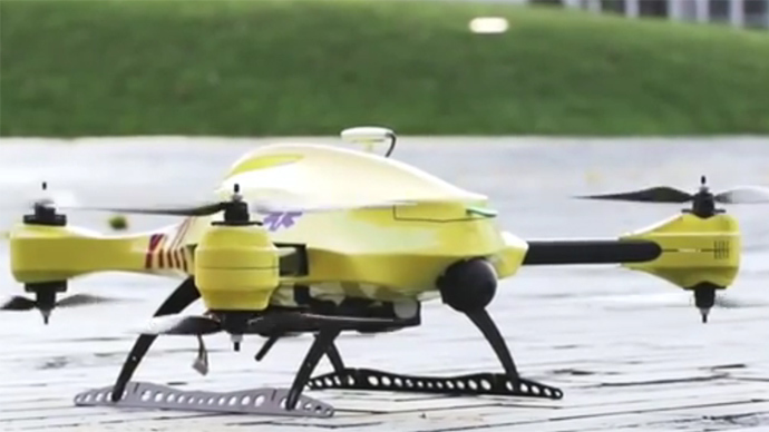
    1. Please describe LiDAR systems available for UAVs.

    There are many lightweight LIDAR systems on the market for UAV applications — some even come integrated within their own operational drone system. Coupling drone-mounted LiDAR systems with vision cameras, advanced computer processing and GPS, it has now become possible to create a remotely piloted flying LiDAR scanner.

    Routescene's LiDAR pod attached to the belly of a UAV.
    Routescene’s LiDAR pod attached to the belly of a UAV.
    1. Update us on legal matters within the European Union?

    The EU has been very active in preparing for the commercial use of UAS, so drone use in the EU appears to be significantly higher than in North America because of the proactive effort of regulators to introduce drones into regular commercial applications. This Forbes article summarizes the approach being taken and the progress towards introducing regulations within the EU by the end of 2015.

    1. You speak of “UAV navigation in environments where traditional GPS receivers may fail.” Are you considering indoors navigation or “just” urban environment?

    It’s true that drones are being operated indoors — for instance, within restaurants. In these environments, all the typical indoor navigation techniques will be viable — RF/magnetic fingerprinting, Bluetooth beacons, Wi-Fi source databases, cellphone signals including small cells, and even optical sensors, all often combined with indoor maps.

    Urban environments with a restricted view of the sky also continue to challenge GNSS only navigation, which has led to extensive use of integrated inertial/GNSS navigation sensors.

    1. Modularity of UAVs? Different sensors for different types of applications using the same UAV?

    A number of professional drone manufacturers offer UAS that could carry different payloads. However, most manufacturers seem to focus on particular applications (flying camera, LIDAR and/or video survey) and don’t carry an extensive range of optional third-party payload equipment.

    1. What regulations are there for self-made UAS?

    It’s hard to imagine that the regulations would be different for a commercially manufactured drone or a home-built UAS. Only time will tell as regulations are developed that include this category of UAS.

    1. What background and abilities should a team possess if it wants to develop a UAV?

    An engineering team that takes on developing a UAV needs to be aware of the basics of flight, navigation and control/communications — these are the principle elements of UAV operations.

    1. Do you exploit software-defined radio techniques?

    Software-defined radios may find their way into UAVs whenever weight/volume are an issue, but they potentially require higher computing capability, and maybe somewhat higher power to run co-processors. Weight and power consumption are at a premium on small UAVs, so any initiative that saves in these areas will no doubt be welcomed.

    1. What are the emerging application areas for UAVs?

    It would seem that the application areas for UAVs are virtually unlimited. High interest areas include agriculture, pipelines, buildings and transmission line inspection, aerial survey, filmmaking and newsgathering, wildlife and environmental monitoring, fishing and military reconnaissance/weapons delivery. But there are many, many applications, some of which might not fit into this summary of applications.

    1. When will the UAV market move beyond focusing on the drone itself and get to the important topic of what sensor technology and back-office systems provide the best value to the user? The UAV is a commodity.

    Good comment — the utility of the UAV comes from the payload it carries and the analysis of the data it collects and how it can be operated.

    1. I’m curious if the UAV mission will be used in conjunction with autonomous agricultural tractors and construction machinery. I’m assuming an off-site tractor operator would benefit from the aerial data for their scope of work.

    Absolutely — another possible UAV application.

    1. Do you know when high-altitude long-endurance solar-powered UAVs will start being used?

    The key application being pursued by Google using high-altitude, long-endurance, solar-powered drones is to provide Internet coverage in areas that currently have no ground infrastructure. A number of countries around the world would benefit from connection to the Internet using this approach. Unfortunately, the prototype aircraft built by Titan Aerospace recently crashed. But Google has vowed to continue with its efforts. Another development, called Project Loon, involves the use of high-altitude balloons and is already well underway.

    1. I am currently enrolled in the UAV Pilots Certificate Training Program offered through the Unmanned Vehicle University. Is this certificate, which costs $3500, going to actually benefit me in my future commercial operations? Does the FAA recognize it as anything valid? So unless the certificate provides me some practical advantage, I’m not sure if it was legitimate or a scam. Any thoughts on this or experience with this “University”?

    A recent Senate bill seeks to establish the six FAA test centers as the authorities for training UAS pilots. However, it would appear that currently no universal training course has yet been developed or approved for UAS pilot training — so it may be premature at this stage to engage with third parties for training until guidelines are published by the FAA.

    1. What is the positional uncertainty associated with the locational measure of GPS systems on these UAVs? What will it be in five years?

    Depending on the application, accuracies between 1 meter and a few centimeters are being achieved. For higher accuracy requirements such as precision surveying, post-processing of data collected during a survey can provide accuracies within a few millimeters.

    In five years’ time there will be more satellites in more constellations, and it’s possible that accuracies could improve further. However, the most benefit will come from having more reliable signals, more often, thereby reducing re-test and operational costs.

    1. What industry do you see being the fastest adopter of UAV technology in the USA?

    The U.S. military is already leading in the number of applications, number of operational UAS and number of different types of vehicles. Commercial applications have increased substantially now that the FAA has authorized a large number of civilian operations in the last year or so. There are a number of film and TV applications for movie-making and newsgathering, and this appears to be a growing area for commercial UAS. Aerial survey is also growing in popularity, and there is a huge range of monitoring applications for building inspection, pipeline and transmission line inspection, and also for crop growth monitoring — which may turn out eventually to have the highest number of applications in the U.S.

    1. How do you think the industry should protect UAVs from GPS spoofing and other forms of remote or internal component (example ICS or SCADA) attacks?

    Solutions to mitigate GNSS spoofing and signal jamming are currently high on the list of most receiver manufacturers’ development agendas, with several options already having reached the market. Anti-jam antennas, improved signal rejection in RF front ends, and algorithms that claim to be able to deduce and overcome spoofing attacks — these are the leading solutions that have been fielded. But we have only just scraped the surface of deceptive techniques being used and the frequency with which they are being encountered, so we should continue to see the solutions evolving to counteract more sophisticated interference and spoofing capabilities over time.

    1. Will the upcoming regulations only impact commercial users, or will they also directly affect non-commercial and/or recreational operators?

    In the U.S., regulations governing the operation of recreational or hobby aircraft appear to be less stringent than, say, a drone operating commercially. As long as common sense rules are observed, hobby aircraft operators have been able to operate without the FAA looking over their shoulders — provided they stay below 400 feet in an open space away from sensitive areas such as schools or hospitals and don’t make an inordinate amount of noise, no one has yet proposed more restrictions for hobbyist model aircraft operators. The focus for the FAA is currently on bringing drones safely into the national airspace system for commercial operations, so regulations so far have been mostly formulated to enable this to happen.

    1. Proposed legislation in the USA refers to one pilot per vehicle; no mention is made of swarming or control of multiple vehicles per pilot. Is it worth developing apps that use swarms of UAVs at the moment?

    Certainly, it’s been difficult for the FAA to introduce regulations for UAS that are acceptable for most anticipated commercial operators, while still respecting and protecting current manned aircraft operations. So far, we’ve had case-by-case approval for specific operations, while regulations for small UAS (sUAS) have only just been circulated for comments — and a huge number of comments have been received. So regulations for “regular-sized” and operated drones and for larger vehicles have not yet seen the light of day. So, the more complex applications involving the operation of a swarm of UAS may not yet have been even considered by the FAA. It has taken years to get this far, and we still don’t have any published regulations for any class of UAS in commercial applications, so it’s doubtful that there is any work underway on regulations for swarming drones. So develop apps if you wish, but don’t expect much regulatory support for some time yet.

    1. What assurance do we have that a UAV operator won’t deliver a weapon instead of an Amazon purchase?

    The exemptions that have been published allow certain well-defined, specific commercial operations of UAS. The unmanned vehicle has to be registered to an individual and get a unique tail number. The operators have to be identified and must regularly demonstrate proficiency and adequate knowledge to become a recognized operator. So authorities get to inspect the UAV, know the owner and know the operator, and even get to review and approve the location of each UAS operation — not that that would prevent someone subsequently modifying the vehicle to carry ordinance, or knowingly attacking a target. It would, however, be pretty easy to track down the offender, but that doesn’t really prevent “weaponization” or delivery. But we are only at the small-vehicle-level currently, so its doubtful if major damage would be possible with small weapons, but an individual attack might still be lethal. Careful screening of individuals seems to be the route the regulators have taken to minimize this risk. This is still a difficult issue that is going to take some policing and close control.

    1. Instead of an actual pilot’s license required for legal flight of a UAV, do you think an all-encompassing UAV pilot’s license will be required? I ask because I am a trained Trimble UX5 pilot, but I do not have my pilot’s license. I also build UAVs, and I am curious how I would get a UAV pilot’s license for a UAV I built? Unless they had an all-encompassing training course for pilot/flight safety.

    The FAA proposed rulemaking for sUAS operations did not require operators to have a pilot’s license. Instead, UAS operators are required to undertake a specific recurrent training course for UAS operators, administered by FAA qualified trainers. Regulations relating to “home-built” UAS have yet to emerge, and may be some time away from publication.

    1. It is said that mainland China has over 70% of the world UAV market? How did we fall so far behind?

    Lack of regulations in the U.S. may have held back U.S. industry — see related comments by Amazon in testimony to the U.S. Congress.

    But also the absence of restrictions in other countries may have helped overseas manufacturers get established and to gain initial market share. While the majority of done R&D was initially within the U.S., it’s clear that DJI and its Phantom line of drones have become very popular, very quickly. Strangely enough, the largest concentration of buyers and operators currently appears to be in the U.S.

    1. Insurance against UAVs crashing and causing damage to humans: what progress has been made in this area?

    Several insurance companies are now writing risk-coverage policies for UAS, including Global Aerospace, USAIG, Allianz and AIG.

    1. We are operating a GNSS reference network in Greece, SmartNet-Greece (Leica Geosystems). Is there a tested NTRIP system on UAVs, to be connected and monitored to Ntrip caster? How could this augment real-time GNSS accuracy of UAVs?

    Seems like you are trying to get RTCM corrections from a ground network to a flying UAV – correct? So do we need an Internet connection to get your ground network RTCM corrections onto the UAV? I’m not an expert on available mobile Internet hook-ups, but most smartphones have one, so it can’t be that hard to add this onto a UAV. Alternatively, wouldn’t it be easier to have the GNSS receiver on the UAV listen to a PPP broadcast from one of the several services providing these corrections? We could get down as far as 10 cm accuracy with one of these commercially available correction services.

    1. Talk about the possibilities of precise positioning in UAVs, instead of mapping.

    Precise real-time positioning on a UAV is a question of which GNSS receiver is onboard and which PPP or local RTK network transmissions are available in the area of UAV operations. Positioning accuracy is possible of a few centimeters down to a few millimeters post-processed.

    1. Realistically, how close are we to being able to fly UAVs for commercial applications such as topographic surveys and earthworks applications such as mining sites?

    As we heard during the webcast, obtaining an FAA section 333 exemption is quite possible for these applications, and some have already been granted. The FAA has been streamlining the process recently to reduce the time it takes to obtain these authorizations.

    1. What is a practical ceiling for UAV flight?

    The FAA has limited UAS operations to below 400 feet in the Section 333 exemptions that have been granted, while 500 feet is used as the maximum ceiling in the proposed draft sUAS regulations.

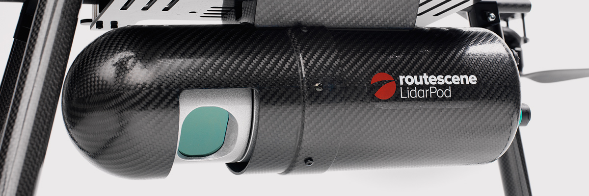
    1. What is status of technology for “see and avoid” requirements for UAVs?

    NASA, the Federal Aviation Administration (FAA), General Atomics Aeronautical Systems (GA-ASI) and Honeywell International Inc. have successfully demonstrated a UAS proof-of-concept sense-and-avoid (SAA) system. GA-ASI worked with NASA’s Armstrong Flight Research Center to integrate the new system aboard NASA’s Ikhana research aircraft, a civilian version of the company’s Predator B. The flight-test campaign in November and December 2014 evaluated the SAA system in a wide variety of collision-avoidance and self-separation encounters between two remotely piloted aircraft and various manned aircraft and included a sensor-fusion algorithm being developed by Honeywell.

    NASA's Ikhana Predator B drone.
    NASA’s Ikhana Predator B drone.

    An RTCA subcommittee is also working in parallel to develop the requirements for an SAA system, and these flight-test evaluations will contribute to those technical standards.

    Other companies that are also thought to be active in SAA development include Rockwell/Collins, Sierra Nevada and Insitu/ Queensland University of Technology Australia.

    So, a large number of questions on a pretty wide range of subjects — hopefully some of the answers we’ve provided will be of assistance — but please provide us with your comments if you have information to share.

    Tony Murfin
    GNSS Aerospace
    [email protected]

    Disclaimer: The statements, questions, views and opinions presented in this article are those of the author and webcast audience, and may not necessarily reflect the opinions of GPS World magazine, its owners or staff. Readers are also warned that the answers are provided on a best-effort basis and could be less than 100% correct.

  • ION-JNC and the Nascent Paradigm

    ION-JNC and the Nascent Paradigm

    In late June, I had the honor and privilege of attending and participating in the Institute of Navigation’s Joint Navigation Conference (ION-JNC) in Orlando, Fla. This year attendance was up by 20 percent. The entire event was FOUO (For Official Use Only) with a classified (SECRET) day on Thursday held at, as improbable as it seems, a joint military and Walt Disney location known as Shades of Green. It gives Mickey Mouse and the military a whole new meaning!

    The classified day included a remarkable War Fighter Panel, which, full disclosure, I have had the honor along with my colleague Jim Doherty at IDA (Institute For Defense Analyses) of co-chairing for the last several years. It is always heart-warming and invariably enlightening to hear our warfighters discuss capabilities that GPS enables for them in times of peace and war. You could even say this was the theme of the conference: “The capabilities that GPS technology enables.”

    You might assume an FOUO- and SECRET-level conference would be slim pickings for a journalist. If that is all that transpired, then you would be correct; however, all the conversations outside the official sessions, especially around the displays and exhibitors’ booths, make it more than worthwhile. Not to mention all the tidbits you pick up at breakfast, lunch, dinner and evening socials. One of the most common phrases I heard all week was, “Now don’t quote me on this, but…” or the one I like to hear, “OK, this is on the record” or “You are recording this, right?” Everyone has a message!

    ION-JNC in Dayton, Ohio

    For the next two years (2016-17) ION-JNC will be held in beautiful downtown Dayton, Ohio, at the Dayton Convention Center. Dayton is home to the famous Wright Brothers Cycle Shop and the Wright Flyer.

    Take-off of the 1903 Wright Flyer, the world's first powered, sustained and controlled heavier-than-air flight on Dec. 17, 1903.
    Take-off of the 1903 Wright Flyer, the world’s first powered, sustained and controlled heavier-than-air flight on Dec. 17, 1903.

    Dayton also hosts the world-famous National Museum of the USAF (United States Air Force) located on Wright-Patterson Air Force Base (WPAFB). The classified day will be held at the prestigious USAF Institute of Technology (AFIT), also on WPAFB, where many an Air Force officer has earned a master’s and or Ph.D. The papers and sessions should be outstanding in view of the venue and the presence of the Air Force Research Laboratory (AFRL) at WPAFB, which is known as the Air Force’s only organization wholly dedicated to leading the discovery, development and integration of warfighting technologies for air, space and cyberspace forces.

    Register early and send your clearance if you have one; it just gets better every year.

    SpaceX and Falcon 9

    Elon Musk,CEO Space Exploration Technology Corp. (Photo Courtesy of Tesla Motors)
    Elon Musk,CEO Space Exploration Technology Corp.
    (Photo Courtesy of Tesla Motors)

    I arrived in Orlando on Sunday, June 21 (yes, I traveled on Father’s Day) because events start bright and early Monday morning, to hear about the Falcon 9 launch failure, the first for that family of launchers. Even though it occurred 130+ seconds into the launch segment, if the rocket fails to deliver the payload or supplies to orbit or their destination, it is generally referred to as a launch failure. Technicians and subject-matter experts will be debating for some time exactly what caused the failure, but there can be no doubt this is a big blow to the Space Exploration Technology Corporation — better known as SpaceX.

    I have known Elon Musk and experienced his outsize ego casually for more than 20 years, and I am constantly amazed at his accomplishments and would never bet against him. I do not mean the ego remark in a negative way, because history proves that if Elon says he will accomplish the seemingly impossible, then he will do just that. Can you say Tesla Motors? Setbacks just make him and his team more determined.

    “It is difficult to say what is impossible, for the dream of yesterday is the hope of today and the reality of tomorrow.” — Dr. Robert Goddard

    Gwynne Shotwell, COO Space Exploration Technology Corporation. (Photo Courtesy of SpaceX)
    Gwynne Shotwell, COO Space Exploration Technology Corp. (Photo Courtesy of SpaceX)

    However, launch setbacks are played out on a national stage where lives may well be at stake. SpaceX President and COO (Chief Operating Officer) Gwynne Shotwell, the brains of the outfit, who is as alluring as she is brilliant, said following the launch failure, “I’m sure we will find the cause rapidly and resume normal launch operations within a year.”

    Reportedly, SpaceX is already a bit tardy in scheduled launches with an enviable backlog totaling approximately $7B, many of which are government payloads. In the end, this merely highlights that the launch business is a tough nut to crack, and attention to detail is paramount. Every little detail must be scrutinized numerous times.

    BAR

    In the mid 1990s, Dr. John Darrah and I (then AFSPC Chief Scientist and Deputy respectively) under the auspices of Air Force Space Command and the Institute For Defense Analyses (IDA) formed a high-level group of subject matter experts (SMEs) to review why the U.S. government, in the matter of a few months, put several billion dollars worth of space hardware into saltwater instead of the vacuum of space. The group was labeled the BAR, or Broad Area Review, and its task was to euphemistically “bar” this type of abnormal launch activity from ever happening again. I can honestly say the BAR has been wildly successful.

    There have been five separate BARs to date, and there has not been a military or national security space launch failure since the BAR’s inception. There have begen more than 120 successful launches by Lockheed Martin, Boeing and the combined organization known as ULA or United Launch Alliance. I am not at liberty to reveal the findings of the various BARs, but obviously attention to detail is key to any successful endeavor.

    SpaceX vaulted from an upstart small company with a few employees to a certified government space launch contractor with more than $7 billion in contracts and 3,000+ personnel on the payroll in only 13 years. SpaceX previously successfully launched two cargo resupply missions to the space station. To date, it is the only predominantly commercial space company to accomplish that task.

    Therefore, I am sanguine without a doubt (now I sound like Elon) that SpaceX will quickly discover the malfunction that caused the launch failure and correct it immediately. This is not to say that anyone at SpaceX has been intentionally careless, but the successful space launch business today is by necessity an OCD (obsessive compulsive disorder) culture of attention to detail where items are checked not once or twice but 20 times to make sure nothing has been overlooked or assumed. However, for SpaceX the critical task, for the success of the company and future astronauts’ lives, depends on SpaceX’s assurance there will be no more failures for any reason. The U.S. military has proven for the last 16 years — 16 years without a single national security space launch failure — that it is an achievable goal. Note: Currently SpaceX launches do not fall under the purview of the BAR, a situation easily rectified.

    Assured Access to Space

    General (USAF, Ret) Thomas S. Moorman Jr. (Photo Courtesy of the USAF)
    General (USAF, Ret) Thomas S. Moorman Jr.
    (Photo Courtesy of the USAF)

    Lest we forget, behind all the technological arguments and/or failures is the crux of the matter, which is nothing less than assured access to space and all that capability enables, which of course includes GPS. In 2006, General (USAF Retired) Thomas S. Moorman Jr., former AFSPC commander and VCSAF, wrote in the highly esteemed AFSPC publication High Frontier regarding a Senior Leader’s Perspective on Assured Access to Space. He stated clearly that

    “Assured access [to space] is a requirement for critical national security, homeland security and civil missions, and is defined as a sufficiently robust, responsive and resilient capability to allow continued space operations, consistent with risk management and affordability.”

    In referring to his now famous and eponymous study, he stated that,

    “The study found that most people wanted to describe assured access in terms of reliability. As the study team progressed in our analysis, it became apparent that often what people were describing was the need for resiliency rather than reliability. Reliability describes the dependability of a specific booster while resiliency considers the collective ability of all available launch systems to meet national security need.

    “While our recent launch record…is indeed impressive, we should not rest on our laurels. Assured access is not a destination, but rather a journey. As a nation, we need to continue to adequately fund space launch operations and develop the next-generation technologies that will increase responsiveness, improve reliability, and reduce costs. Through these actions, we can ensure the nation will have continuous, uninterrupted access to space for decades to come.”

    In that light it is possible — even probable — that SpaceX will help us strive, reach and continue with that vaunted goal; contrarily, you may remember a few months ago SpaceX sued the U.S. government because the government was not moving quickly enough for Space X with certifications and validations for SpaceX launch vehicles. The U.S. government knows first hand how difficult the space launch business can be, and it wanted to ensure that not only was SpaceX ready but that their family of vehicles were reliable. The government’s caution has unfortunately been validated, as this was the second SpaceX launch failure, although the first and hopefully the last in the Falcon 9 family of vehicles. All is not lost, and the future actually looks bright for SpaceX if it will just put egos aside, listen to the launch subject matter experts and pay attention to every little detail.

    Competition may well be viewed as a “good thing” in the space launch business. However, it is always trumped by assured access to space, which is a critical national security requirement. Competition and national security needs must be balanced with the emphasis on what is gained by assured access to the high ground of space. Elon Musk, Gwynne Shotwell and the SpaceX team may well be capable of showing the rest of us “how it is done,” but first they must demonstrate unerring dependability, reliability and resiliency. I wish SpaceX the best of luck and every success.

    Nascent Leadership Paradigm — People on the Move

    For some unfathomable reason, at least intellectually, all the USAF Leadership Schools, or at least the majority, are located in Montgomery, Ala. Now personally I happen to like Montgomery and its laid-back southern charm. It was also once the capitol of the Confederacy, which is apropos nothing except it seems to be a hot topic or trigger word these days. Be that as it may, Montgomery and Air University are not exactly Oxford, Cambridge or Eton, and yet the university in its many incarnations has produced outstanding military leaders in its 95-year history. And yet in my numerous tenures at this prestigious institution, it has been made clear by the staff that this is an institution with bipolar tendencies.

    On the one hand, it is made clear to every officer and student that the national military establishment thrives on rules and regulations, and those wishing to abuse or ignore them can readily and rapidly be replaced. Some instructors I encountered (not all certainly, and probably not the cream of the crop) would have you believe that individualism has its place — just not in the U.S. military. Then, in the next class or session, you hear stories about visionaries such as Claire Chennault, Jimmy Doolittle and William “Billy” Mitchell, who never colored within the lines. Not to disparage Air University, but I have always had a problem with this school tenet, as it tends to disregard personality, relationships and leadership. I often think of General Dwight Eisenhower’s comments concerning his rebellious, unorthodox and rule-breaking friend U.S. Army General George Patton. Eisenhower made numerous famous comments about Patton’s rebellious nature, his inability to follow orders and his swashbuckling uniforms that once paraded 24 general’s stars at one time on one non-standard uniform, and yet in official comments written after Patton’s untimely death Eisenhower wrote:

    “He [Patton] was one of those men born to be a soldier, an ideal combat leader whose gallantry and dramatic personality inspired all he commanded to great deeds of valor. His presence gave me the certainty that the boldest plan would be even more daringly executed. It is no exaggeration to say that Patton’s name struck terror at the heart of the enemy.”

    In other words personality, individualism, reputation and leadership do make a difference, and in times of war, leaders bearing those qualities are difficult if not impossible to replace. But in times of peace, those qualities still matter, and we should never take those leaders for granted. I mention this because in the past several months, several Air Force leaders considered key to the GPS program have either retired, been promoted or left government service for personal reasons.

    USAF General Ellen Pawlikowski is only the third female four-star general in USAF history, and she recently left SMC (Space and Missile Systems Center) for a job at the Pentagon, where she worked space and GPS acquisition and policy issues. From there she was promoted to four stars and now sits as just the ninth commander of Air Force Materiel Command. Gen. Pawlikowski was replaced at SMC by Lt. Gen. Samuel Greaves (USAF).

    Brigadier General William Cooley (USAF) recently pinned on his first star while serving as the director of the GPS Directorate at SMC. He was recently selected for reassignment as program executive, Programs and Integration, Office of the Under Secretary of Defense for Acquisition, Technology and Logistics, Missile Defense Agency (MDA), Redstone Arsenal, Alabama —an organization where Lt. Gen. Sam Greaves once served as the deputy commander. Can you say career broadening? Brig. Gen. “Wild Bill” Cooley is being replaced by USAF Colonel Steve Whitney, who has distinguished himself with yeoman service at the directorate as the GPS Military User Equipment (MUE) guru.

    David W. Madden serves as a member of the Defense Intelligence Senior Executive Service and functions as the executive director, Space and Missile Systems Center, Air Force Space Command, Los Angeles Air Force Base, Calif. He is the senior civilian executive and the deputy program executive officer for Space. His responsibilities include managing the research, design, development, acquisition and sustainment of satellites and the associated ground command and control systems and user terminals. In his military career, Dave served as the GPS Wing Commander at SMC. For personal and professional reasons, Dave has decided to leave government service soon, and my sources tell me he will take up a position in Denver, Colo. Unfortunately, I am not currently at liberty to say where. I have been told the name of Dave’s replacement, but it was in an FOUO session and therefore not currently releasable. Suffice it to say, the individual is eminently qualified.

    Each of the individuals mentioned has a very strong personality and a certain way of doing business. I have known them all for years and can honestly say their personalities and personal leadership styles dominated their successful careers to date. Frankly, I don’t see that changing. So, when you hear that military personnel are interchangeable and personalities don’t matter, as I unfortunately heard a very senior official say publicly recently, please take that with a huge grain of salt and skepticism. People, personalities and leadership styles do matter, especially outside-the-box thinkers and leaders. Let’s wish everyone the best in their new endeavors.

    Until next time, Happy Navigating, and remember: GPS is brought to you courtesy of the United States Air Force.

  • Out in Front: The State of Our Union, 2015

    Sometimes you have to stop and, yes, smell the roses, but also survey just how far you’ve come, where you stand at this actual moment, and what directions hold the most promise for the future. When you’re moving as fast as the GNSS and PNT industries do, a periodic pause to assess becomes even more vital.

    That’s why we conduct the annual State of the Industry Survey, which generates the State of the Industry Report.

    Your part in this, the Survey, starts July 15, when the online survey will be posted at env-gpsworld-integration.kinsta.cloud/State15, and remain at that link until August 10.

    Our part, the Report of your filings, will appear in the September issue.

    Past State of the Industry Reports have borne such insights as these.

    September 2012. “Careful optimism appears to be the watchword for the GNSS industry as we head into the next year, tempered with the reality that a full economic recovery has not yet arrived; 65 percent of respondents described the market for GNSS products and services as enjoying either moderate growth or strong growth. ‘With the economy in the state it is in, competition is very tight. That is all right, it keeps our pencils sharp,’ wrote one industry veteran.”

    September 2013. After the passage of one year, 69 percent described the market for products and services in their sector as either relatively healthy or very healthy. That’s what’s known in economic circles as “a modest increase.”

    Dominating executives’ and managers’ awareness as a key issue shaping the future that year were three candidates, according to John Pottle of Spirent Communications. “Vulnerability of GNSS signals, the flurry of activity following the release of the BeiDou system ICD, and the continuing indoor navigation challenge. Whatever your viewpoint, one thing is clear: there remain plenty of challenges for us all, as indusry insiders, to solve over the coming years.”

    October 2014. With another 13 months under our collective belt, we had not fully mastered any of those top three challenges — but we had logged significant progress. Jamming, both intentional and unintentional, along with spoofing led all concerns for 28 percent of survey respondents, and if “constellation health” were added to those worries, fully half of our experts — meaning you — deemed this the industry “issue of the year.” Meanwhile, the percentage of those finding moderate to strong growth in their sector had risen to 74.

    Michael Ritter of NovAtel spoke for many when he wrote, “Ultimately, GNSS itself will no longer be enough. Ubiquitous positioining requires multi-sensor fusion that can exponentially increase availability.” And he revealed that NovAtel spends 30 percent of its annual revenue on research and development.

    The Future Begins Now. Only you, in your collective wisdom, can tell us where we stand and where we’re headed. I encourage you to help us compile the State of the Industry by filling out a relatively quick online questionnaire. Look for it to be posted on July 15.

  • Expert Advice: The Tigers Claim Their Territory

    Expert Advice: The Tigers Claim Their Territory

    Tigers-CSNC2015

    Report from the 2015 China Satellite Navigation Conference

    By Greg Turetzky

    This May, the sixth China Satellite Navigation Conference (CSNC) was held in Xian, site of China’s famous buried warrior tombs. This was the fourth time I have attended, and every year the event has grown in both attendance numbers and global importance.

    The conference opened with the usual provider updates on satellite systems and international collaboration. There was nothing truly unexpected. All the providers continue to make progress towards launching new satellites with new capabilities, as well as providing regional augmentation systems for aircraft navigation.

    The hosts were their usual gracious selves and put on a very entertaining evening at “The Night of Beidou” event with wonderful food as well as music, dancing and and acrobats.

    Tigers-pullquote

    Exhibit Hall

    The show floor continues to grow at a rapid rate. The program listed122 exhibitors. The market has clearly entered the rapid proliferation stage. The booths were large, well-staffed and busy even during times when technical sessions were in progress. It was hard for me to determine what kind of business was being conducted as there were not many booth staff that spoke English. However, that seemed very appropriate as it was clear that the Chinese domestic market for BeiDou, or BDS, is well established and growing.

    In fact, many of the booths were regionally sponsored as there seems to be plenty of local subsidization to grow the GNSS industry in all areas of China. Many companies were displaying end-user products for all segments, from watches to phones to automotive to survey. I also noted significant growth in the number of chipset suppliers; I stopped counting at 10. Of further note and interest, the first few mergers/partnerships have taken place, as the market starts to make its natural turn from proliferation to consolidation.

    Technical Sessions

    The technical content of the conference is impressive. Approximately 280 papers were presented in up to nine simultaneous tracks over three days. Another 100+ posters were available for viewing.

    Here are titles of a few of the papers I liked:

    • Analysis of relative positioning performance of BDS triple frequency
    • Anti-spoofing design for Civil Navigation Signal system
    • Clock-error resolution strategy and precision analysis of GNSS real-time precise satellites
    • Research on detection and identification methods of satellite navigation RAIM multi-satellite failures.
    • Research on Wi-Fi/INS indoor pedestrian navigation system based on environmental feature augmentation
    • Reflections on demands of BDS intellectual property rights in satellite navigation industries
    • Review of anti-interference RF of satellite navigation receivers
    • A new TOA estimation method for the navigation pulse of X-ray Pulsare.

    If you plan to visit next year, you should consider bringing a translator. Many of the sessions have simultaneous translation, and most of the presentations have both English and Chinese slides, but not all of them. In the past, I have always enjoyed the policy and IP session, but this year it did not have a translator and the presenters spoke in Chinese, so I cannot give you much information. I did notice that several other U.S. companies had sent representatives who were native Chinese speakers.

    Conclusion

    The Chinese market is now full of grown tigers. I think they worry more about domestic competition for large domestic opportunities than they do about foreigners taking market share from them. That kind of competition has spurred them to catch up quickly in terms of technology and performance to where the big foreign competitors are. I foresee intense domestic competition in the short term leading to fewer, bigger, stronger players who will then be well positioned to compete in the global marketplace.


    GREG TURETZKY is a principal engineer at Intel responsible for strategic business development in Intel’s Wireless Communication Group focusing on location. He has more than 25 years of experience in the GNSS industry at JHU-APL, Stanford Telecom, Trimble, SiRF and CSR. He is a member of GPS World’s Editorial Advisory Board. See his previous reporting on the 2014 CSNC, “Tigers, Tycoons on View at China Satnav,” and the 2013 conference, “Little Tigers versus Wolves.”

    The statements, views, and opinions presented in this article are those of the author and are not endorsed by, nor do they necessarily reflect, the opinions of the authors present and/or former employers or any other organization the author may be associated with.

  • EGNOS Dream Now a Reality

    EGNOS demonstration equipment aboard a new Airbus A350 WXB.
    EGNOS demonstration equipment aboard an Airbus ATR-42. (Photo by Tim Reynolds)

    Toulouse, France, an aerospace city and the center of the French aerospace industry, was the birthplace of EGNOS, Europe’s satellite-based augmentation system (SBAS), in 1994. So it was appropriate that the first-ever EGNOS Flight Event was organized there in May by the European GNSS Agency (GSA) and the European Commission.

    EGNOS is the acronym for European Geostationary Navigation Overlay Service. It is also songe — the French word for “dream’”— spelled backwards and, according to Jean-Luc Moudenc, mayor of Toulouse, that is how the name originated.

    The dream is now very much a reality. Since its certification for civil aviation in 2011, EGNOS has made steady progress in implementation. Today, 111 airports in 15 countries across Europe benefit from EGNOS, and many more are preparing for implementation — 171 LPV (localizer performance with vertical guidance) and 86 BARO approaches are already certified for use.

    The EGNOS Flight Event was organized in collaboration with Airbus and brought together aviation media and other sector stakeholders for a briefing and demonstration of EGNOS, how it works, its benefits for aviation and a glimpse at its future.

    The state-of-the-art Airbus A350 WXB is the first wide-body airliner equipped with the SLS.
    The state-of-the-art Airbus A350 WXB is the first wide-body airliner equipped with the SLS. (Photo by Tim Reynolds)

    EGNOS for Airbus

    It was clear that Airbus sees integration of EGNOS, and SBAS generally, into the avionics of its product offerings, from helicopters to the giant Beluga transport plane, as very much part of the future.

    A highlight of the event was a “show and tell” with the Airbus A350 WXB — a real beauty of an airplane. Participants were given a tour of this new state-of-the-art wide-bodied airliner, including a simulation of an EGNOS-enabled LPV landing in the cockpit. Airbus test pilot Jean-Christophe Lair described the A350’s new Satellite-based Landing System (SLS) that works with SBAS such as EGNOS. This is the first time such a system has been installed on a wide-body airliner and will be supplied as a standard feature to all customers.

    EGNOS is fully integrated into a common harmonised landing system interface on the A350 — the SLS — that allows the pilot to fly precision approaches like an ILS with geometrical vertical guidance down to 200 feet. This new navigation system will allow Airbus users a wider range of solutions to optimise operations and increase accessibility without any compromise on safety.

    “All the systems look the same to the pilot — it is a seamless integration of EGNOS — so no human-factor issues,” said Jean-Christophe. Pilot feedback had been excellent with some 3,000 hours flown on LPV approaches using both EGNOS in Europe and WAAS in North America. “We have experienced no technical or operational issues with SBAS operations,” he claimed. “The SLS shows value every day that it is used.”

    SLS/LPV is operationally equivalent to CAT 1 ILS, but brings significant additional assets above the LPV minimum such as the secure coding of the final approach segment and the fact that the SBAS/ LPV vertical profile is geometric and fixed in space. The system can also be useful for creating en-route diversions and allows creation of instrumented approaches. Overall the SLS development on the A350 XWB had been a very positive experience he stated.

    Earlier Philippe Rollet, senior expert Air Traffic Management at Airbus, had said that “EGNOS was more important for helicopters than aircraft.” The enhanced EGNOS guidance enabling access to helipads in urban environments. “With EGNOS you can have a helipads everywhere and the system increases operational safety in bad weather,” he claimed. “For Airbus all new helicopter models will be EGNOS capable – it is the baseline for Airbus.”

    This enhanced access facility was demonstrated via the GSA-funded GARDEN project that is using EGNOS to enable increased safety and better access for helicopters, for example, enabling air ambulances to more easily access city centre hospitals. EGNOS implementation was demonstrated in the cockpit of an Airbus H175 multi-mission helicopter used as a test-bed for GARDEN.

    Technology at Work In Flight. EGNOS was also in action during a series of flights for the media using EGNOS for landing procedures on an ATR turboprop development craft. The plane was equipped with additional avionic displays in the main cabin, and this allowed the press to watch the technology at work without crowding out the pilots on the flight deck! The flight demonstration took off from Blagnac for a 15-minute circuit around the beautiful “pink” city of Toulouse before demonstrating an immaculate EGNOS LPV approach and landing.

    Earlier the “press pack” had also been taken on a tour of the massive assembly plant for the Airbus A380 double-decker airliner next to the airport. Well worth a visit if you are ever in the area! In fact, Toulouse is blessed with aerospace tourism attractions such as the City of Space.

    Expanding EGNOS?

    The media was welcomed to the event by GSA executive director Carlo des Dorides. He emphasised that EGNOS for aviation delivers high precision at low cost. “EGNOS is Europe’s first satellite navigation system — and already has a good success story to tell,” he said. “It helps aviation to be safer, greener and more efficient.” He highlighted EGNOS’s ability to deliver continuous integrity protection in compliance with ICAO standards allowing CAT 1 approaches with more than 99 percent availability.

    “Today 142 airports across Europe are benefitting from EGNOS, and the number is growing steadily,” he said. EGNOS’s success in aviation was also helping to spread the word for applications in other transport sectors such as maritime.

    With a near-term target of 500 runways to be EGNOS enabled in Europe, the support available for airports and operators wanting to benefit from EGNOS was emphasised by Gian Gherardo Calini, the head of market development at GSA. During 2015 the agency has allotted €6 million to co-fund projects to implement EGNOS in aviation. A similar amount had also been allocated in 2014. GSA provided technical and educational support for implementation as well as financial assistance.

    He saw the benefits being increased safety, operational enhancements, plus reduced cost and environmental impact. Widespread implementation would enable new point-to-point commercial airline opportunities.

    Key to Significant Growth. EGNOS could be the key to a significant growth in general aviation in Europe. “The need to install ILS made the business case for most general aviation airfield out of the question,” claimed Martin Robinson, senior vice president of the International Council of Aircraft Owner and Pilot Association (IAOPA). There are 4,649 aerodromes in Europe and some 50,000 general aviation aircraft operating from them. In comparison to the situation in the U.S., only a small percentage the aerodromes had been. Of course, the widespread uptake of WAAS in the U.S. is a clear result of a deliberate federal strategy.

    “There is definitely room for growth,” said Robinson. “EGNOS will help to provide greater access to aerodromes throughout Europe and to improve safety, but we need to be much quicker if we are to realise these benefits sooner.” He felt every general aviation airfield needed a clear business plan working towards EGNOS ability.

    There was some dispute about the exact cost of implementing an EGNOS approach as it varies from location to location, but in broad terms the one-off cost of implementation seems to be equivalent to the annual maintenance cost of on-the-ground ILS equipment. With these economics, wider uptake by regional airports in Europe should be a no-brainer; however, the go or no decision often came down to individuals, said Robinson. He believes European countries need to be more willing to support the European Commission in introducing the technology. Perhaps a more region-led approach is required?

    The French government line on EGNOS was given by David Comby of the French Ministry for Ecology, Sustainable Development and Energy, who said France sees EGNOS as essential part of the modernisation process for European airspace making flying safer, more efficient, greener and more cost effective. France was working hard on EGNOS implementation, and it was possible that all French runway ends (~200) would be equipped for EGNOS by 2018.

    EGNOS over Africa?

    The potential for expansion of EGNOS / SBAS across the globe is huge. Despite having to battle against a barrage of taxiing aircraft noise, Jean-Marc Piéplu Head of EGNOS Exploitation at GSA described the upgrade path for EGNOS from the current Version 2 to EGNOS V3. “Version three will feature new capabilities,” he said. “Dual-frequency and dual-constellation with both GPS and Galileo signals available.”

    In theory EGNOS V3 could provide EGNOS / SBAS coverage for aviation to more than 90 percent of the global land surface. Piéplu indicated that if the political will was there to implement, then this extension of coverage could be accomplished in 10 years. There were no outstanding technical issues. He also said that there were no current plans to use GLONASS signals with EGNOS.

    A key market could be Africa. Establishment of transport infrastructure is seen as a key enabler for sustainable development in the less-developed world, and SBAS-based infrastructure could provide a cost-effective solution to boost connectivity safely without having to invest in vulnerable ground-based equipment.

    Julien Lapie from the Agency for Air Navigation Safety in Africa and Madagascar (ASECNA) highlighted that over 40% of citizens in Africa were more than 250 miles from an ILS-equipped airport. Negotiations on use of EGNOS over Africa are ongoing, but could be completed as soon as 2016.

    As the not-so-subtle EGNOS advertising tag goes: It’s there. Use it.

  • eLoran Progresses Toward GPS Back-Up Role in U.S., Europe

    eLoran Progresses Toward GPS Back-Up Role in U.S., Europe

    eLoran-restart-W
    (fFrom left) Congressman LoBiondo, UrsaNav CEO Chuck Schue and Harris Division President Pam Drew. (hoto Credit: Andrei Grebnev, UrsaNav)

    As of June 19, eLoran is on the air in the United States. The low-frequency signal emanates from a single station, a former U.S. Coast Guard Loran Unit in Wildwood, N.J., which sports a 625-foot signal mast that has been out of action for five years. The signal is receivable at distances of up to 1,000 miles.

    The facility began generating eLoran pulses at the press of a command button by Congressman Frank LoBiondo (R, N.J). Present for the ceremonial start of a 12-month demonstration and research program under the aegis of the Department of Homeland Security were project participants Charles Schue, CEO of UrsaNav; Pam Drew, president of Harris Information Systems; and Dana Goward, president of the Resilient Navigation and Timing Foundation.

    Brief remarks delivered at the turn-on collectively made the key points that:

    • GPS services are essential to national and economic security, yet are vulnerable to disruption.
    • The eLoran navigation and communications signal has  features that are complementary to GPS, making it difficult to disrupt; further, it could be an important part of enabling UAVs to fly safely in our airspace.
    • The U.S. Federal Radionavigation Plan cites not being critically dependent upon a single system for positioning, navigation, and timing as a national policy objective. The plan specifically identifies eLoran testing as an important step toward reaching that objective.

    The two engineering companies, UrsaNav, a supplier of eLoran technology, equipment, and services, and Harris (which recently acquired Exelis), provide funding and technology for the tests supported by the U.S. Coast Guard, Department of Defense, Department of Homeland Security and other federal agencies under a Cooperative Research and Development Agreement (CRADA) announced in May.

    The team will evaluate eLoran as a potential complementary system to GPS, exploring the capabilities and use methods of eLoran in depth to identify all strengths, capacities, and potential vulnerabilities of the technology. One goal of the CRADA is to reduce the size, weight, cost, power needs and other aspects of Loran, similar to what has evolved with GPS.

    “This is a phoenix arriving. We have the opportunity to add 2015 technology to the older idea,” said Schue of UrsaNav, once Coast Guard commanding officer at the former Loran station. “A prudent mariner always has two systems to navigate.”

    Dana Goward, also a retired Coast Guardsman whose non-profit Resilient Navigation and Timing Foundation is working on the project, stated that eLoran can attain positioning accuracy of six meters or better.

    “We will explore many places eLoran can be deployed where GPS isn’t available such as deep canyons, through buildings, in foliage and under water,” added Harris Corp.’s Drew. “We’re involved with unmanned aerial drones, and eLoran could be key. There are applications for civilian and military uses.”

    In this GPS World exclusive video, Admiral Thad Allen, former commandant of the U.S. Coast Guard, discusses PNT alternatives to GPS for navigation, including eLoran and the activation this week of the signal on the eLoran tower in New Jersey.

    eLoran in Europe

    Matters have moved a little further along in Europe. In 2013, the General Lighthouse Authorities of the UK & Ireland (GLA) established prototype eLoran Initial Operating Capability (IOC) in the United Kingdom, where eLoran now delivers PNT data at the 10-meter level from a network of high-power, low frequency, terrestrial transmitters.

    “To get high accuracy from eLoran requires accurate calibration of Additional Secondary Factor (ASF) through measurement,” according to paper delivered at the Institute of Navigation’s 2015 Pacific PNT meeting. “Can eLoran Deliver Resilient PNT?” was authored by Nick Ward, Chris Hargreaves, Paul Williams, and Martin Bransby of the GLA.

    The older Loran-C system suffered from significant positioning bias errors due to a number of radio frequency signal propagation delay factors, they write. “The Primary Factor (PF) is due to the signal travelling slower in air than free-space, the Secondary Factor (SF) is due to the presence of the Earth’s surface and the electrical properties of the oceans. Additional Secondary Factor (ASF) is due to the additional electrical resistance encountered by non-seawater terrain, land, mountains, deserts, and so on. PF and SF can be modeled, but to get high accuracy from eLoran requires accurate calibration of ASF through measurement.

    “To do this,” they continue, “ASF surveying and mapping has been conducted along the port approach channels at Aberdeen; along the Firth of Forth; Middlesbrough; Hull and the Humber Estuary Traffic Separation Scheme (TSS); Harwich and Felixstowe; The ports of London, Medway and the approaches past the London Array wind-farm and also through the Dover Straits.

    “To complement these services, seven differential-Loran (DLoran) Reference-Stations, one located close to each of these survey areas have been established. These stations monitor the time of arrival of the received eLoran signals, and generate differential-corrections that are broadcast via the Anthorn Loran Data Channel (LDC), to account for temporal variations in these ASF maps.

    “Making use of these ASF maps, combined with the locally-produced differential corrections, can allow a maritime user of eLoran IOC to obtain position accuracy of the order of 10m (95%), within a radius of 30 to 50 km of the DLoran reference station.”

    See also “Back-up to Vulnerable GPS Signals Required for Busy Shipping Lanes.

    The GLA authors conclude that:

    1. eLoran can deliver Resilient PNT and this has been demonstrated on several vessels.
    2. Seamless handover from primary (GPS) to secondary (eLoran) positioning source has been successfully implemented.
    3. Surveying and mapping of ASF has been carried out for several major ports and the required levels of performance demonstrated.
    4. DLoran reference stations to correct for short-term, temporal variations have been installed and commissioned.
    5. Good levels of performance have also been demonstrated for coastal voyage phase away from the ASF surveyed areas.

    eDLoran in Rotterdam. The July 2014 issue of GPS World presented a cover story showing results of a newer version, enhanced differential Loran (eDLoran), yielding position accuracies of approximately 5 meters.


    vw-W

    eDLoran: The Next-Gen Loran

    Potential GNSS Back-up Improves to GPS-Level Accuracy

    A new enhanced differential Loran system demonstrates 5-meter accuracy not achievable by the current DLoran system, and requires less expensive reference stations. A prototype tested in Rotterdam’s Europort area uses standard mobile telecom networks and the Internet to reduce correction data latency — a key source of error — by one to two orders of magnitude.

    By Durk van Willigen, René Kellenbach, Cees Dekker, and Wim van Buuren

    Figure 12. The large ship symbol (grey) is derived from the GPS-RTK receiver of the Rotterdam pilots. The width of the ship symbol is 10 meters and the speed-over-ground was 11 kts. The red triangle is generated by the eDLoran receiver and remains between the required ± 5 meter limits for eDLoran.
    Figure 12. The large ship symbol (grey) is derived from the GPS-RTK receiver of the Rotterdam pilots. The width of the ship symbol is 10 meters and the speed-over-ground was 11 kts. The red triangle is generated by the eDLoran receiver and remains between the required ± 5 meter limits for eDLoran.
    Figure 13. The red track is based on raw eLoran data without any corrections. The transparent blue line is made by GPS-RTK and is widened to 10 meters giving the required ± 5 meter limits of eDLoran. The white line is output from the eDLoran receiver which stays within the borders of the 10 meter wide transparent blue line.
    Figure 13. The red track is based on raw eLoran data without any corrections. The transparent blue line is made by GPS-RTK and is widened to 10 meters giving the required ± 5 meter limits of eDLoran. The white line is output from the eDLoran receiver which stays within the borders of the 10 meter wide transparent blue line.

    The GLA authors from the UK give a perspective on the Rotterdam project, as follows:

    “A compatible system (eDLoran) has been developed for operation by ships’ pilots on the Europort approach to the Port of Rotterdam.

    “However, Loran is a regional system dependent on international collaboration. The 9 transmitters in northern Europe are operated by Denmark, France, Germany, Norway and the UK.

    “Both Norway and France have declared an intention to cease Loran transmissions at the end of 2015. Moreover, France intends to dismantle its Loran infrastructure in 2016. Arrangements for the commercial operation of the infrastructure are being investigated, but this depends on some form of regional agreement. The European Union appears to have no policy for resilient PNT, the European Radio Navigation Plan having twice been drafted but never published. The view seems to bee that the introduction of Galileo will achieve resilient PNT, which it will not.”

    And Elsewhere

    South Korea is implementing a national eLoran service, and it is understood that similar plans are being considered in Russia and China.

    Meanwhile, the U.S. Army is interested in eLoran PNT for the warfighter.

  • Autonomous Vehicles Face Privacy, Security and Liability Issues

    Chris Urmson, Google, speaks at ITS America on the future of the self-driving car.
    Chris Urmson, Google, speaks at ITS America on the future of the self-driving car.

    Plus: Resurgence in indoor location-based marketing, ITS America annual meeting report

    Autonomous vehicle technology has made industry-smart people pause and think what the consequences will be if cars and other platforms drive themselves. Will there be a huge increase in traffic when everyone decides to call their cars to grab a loaf of bread at a store? Many of these topics were discussed at the ITS America annual meeting held in Pittsburgh May 31-June 3. In other location news, there seems to be a resurgence in location-based marketing and indoor positioning conferences, leading one to believe that large retailers are finally taking notice.

    By Kevin Dennehy

    Kevin Dennehy
    Kevin Dennehy

    PITTSBURGH — Chris Urmson, Google’s self-driving cars director, told autonomous vehicle proponents what they wanted to hear during his keynote presentation at the recent Intelligent Transportation Society of America’s annual meeting here. He told them that self-driving vehicles will cut down on the 33,000 U.S. traffic deaths each year (“the equivalent of a 737 falling out of the sky five days a week,” he said) and save time and productivity wasted.

    Urmson also said his goal, and his team’s goal, at Google was to ensure son doesn’t have to get a driver’s license, a trend that has become popular with urbanized youth.

    The message was upbeat and timely for the crowd of government and university transportation attendees. However, liability issues continue to surround autonomous vehicle development.

    “In the end, you are always going to have that guy with the ’57 Chevy in his garage. How do you make the autonomous vehicle work with it? It’s akin to the horse and car,” said Ken Leonard, U.S. Transportation Department ITS Joint Program Office director.

    Urmson said he has had “long conversations with insurance companies.” He said that insurance companies are trying to accurately assess risk, and while the model may change, money will still flow, just through a different path.

    One ITS America panel discussed security and privacy issues surrounding connected and autonomous vehicles. One panelist said that while privacy may be dead, security is the real big deal with recent reports indicating that cars’ electronics can be compromised.

    Others believe it’s going to take more time than Google’s assertion that autonomous vehicles will be on the road in five years. “Lessons from the past temper our optimism. While air bags were patented in 1953, and were introduced on luxury models in the 1970s, it wasn’t until the 1990s before there were big penetrations,” said James Anderson, Rand Corp. senior behavioral scientist. “Key takeaways are automaker opposition about the liability [of new technology] and lack of consumer support.”

    The ITS America show floor before the crowds arrive.
    The ITS America show floor before the crowds arrive.

    Anderson said that yes, the lives saved will be a big driver of autonomous vehicles, but congestion will increase, making way for super commuting. “Public transit will also go through big changes. An economic disruption will occur — do you know how much New York City makes from parking alone?” he said. “Safety doesn’t sell in the early stages, as many benefits don’t go directly to the user.”

    Steve Bayless, ITS America vice president of technology, said the solution is not to kill all the lawyers, as there will be continued liability surrounding new in-car technology. “Embedded devices were developed at a time when they were not connected, but the environment has shifted around systems,” he said. “The systems are usually vulnerable because there are poor requirements. Companies have no explicit security policy, or it is poorly specified, or specified too late after design and development.”

    Uber Gets Into Autonomous Game

    The ITS America’s closing keynote speaker was Uber’s head of global public policy, Corey Owens, who said that one of the best cases for autonomous vehicles was the lack of use by consumers of their cars. “In some areas, owning a car is non-negotiable. But how little these cars are used — as many as 95 percent stand idle,” he said.

    Uber announced that Google former head of mapping, Brian McClendon, is joining the company as it develops its own navigation, mapping and transportation systems.

    It’s no secret that Uber is targeting continued autonomous vehicle interest, as it created an Advanced Technologies Center in Pittsburgh. It was also rumored that it was a bidder, with Baidu, to buy Nokia’s HERE digital mapping company. (See more on Baidu in Janice Partyka’s June blog.)

    One major company trying to find its way into connected vehicles, Xerox, exhibited at ITS America in the show’s Entrepreneurial Village. Xerox has installed its smart parking products in such systems as LA Express Park, ParkyIndy and others.

    Xerox has partnered with the University of Michigan Transportation Research Institute in Ann Arbor for testing connected and autonomous vehicles. The company is working with automotive OEMs on electronic tolls, parking, mobile payment and other projects, said David Cummins, Xerox senior vice president and managing director of parking and mobility solutions.

    The U.S. Department of Transportation booth at ITS America focused on the connected car.
    The U.S. Department of Transportation booth at ITS America focused on the connected car.

    Cummins moderated a panel where small companies talked about new technologies and applications like cities without bus stops where a bus is continually moving to the riders on demand.

    In terms of autonomous vehicle use, Cummins envisions an increase in ride-sharing over the next 5-10 years in urban areas. “Initially, there will be a spike in congestion [from autonomous vehicles]. But ultimately, there will be less car ownership,” he said.

    Thoughts on ITS America’s Annual Meeting

    ITS America celebrated its 25th annual meeting in Pittsburgh to an enthusiastic crowd of 2,000 attendees and 125 exhibitors. However, I am not sure if this conference has grown at all, despite claims it had the largest attendance last year (co-located with the larger, and more private-company-friendly, ITS World Congress in Detroit).

    Despite two decades of rhetoric that it is a private-public partnership, the meeting has the feel of a government and university gathering with a few private companies thrown in who want to do business with them. This is a sad thing, as ITS America has embraced the future of autonomous vehicles with excellent speakers.

    Having the meeting in the Bay Area next summer will be a good start to altering the perception that ITS America’s annual meeting is just a government show to “show-the-flag” for private companies.

    Mid-Year Report on Indoor Location

    Earlier this month, executives attended the Place Conference in New York to get an update on indoor location markets and technology for store chains, large department stores and malls. It was also a chance for technology vendors to show new capabilities that have recently reached the market, said Bruce Krulwich, Grizzly Analytics president, who has authored a report on 150 indoor positioning companies.

    Krulwich said, as the year reaches it’s the halfway point, new and more accurate systems are hitting the market. “This includes LED lighting-based systems from Acuity and GE Lighting, and proprietary radio technologies from companies like Quuppa, all of which deliver accuracy of around 10 centimeters with very fast response,” he said. “Some companies, including New York-based Spreo, are improving the quality using standard approaches, like beacons and motion sensing. They are achieving strong accuracy and responsiveness through software improvements. At the same time, hardware-based indoor location technologies, such as Ireland-based DecaWave’s chip and other UWB systems, are coming to market inside highly innovative consumer devices.”

    Going forward, the biggest challenge is moving from the lab to the real world, Krulwich said. “Deployments such as Game Stop stores and Taubman malls are great moves in this direction,” he said.

    In other location industry news:

    • Note to meeting organizers: Do your due diligence to ensure conference dates don’t overlap. Having two major transportation conferences on the same week was challenging to attend: ITS America Annual Meeting and Telematics-Detroit.
    • The brass at Nokia continue to court a consortium of German car makers to buy its HERE navigation business, according to Bloomberg. The consortium, which consists of Audi, BMW and Daimler, is hung up on the price tag of $4.5 billion — and the deadline for bidders has passed, according to the story.
  • Will China Win the Automated Vehicle Race?

    Janice Partyka
    Janice Partyka

    By Janice Partyka

    The race for the automated vehicle is on. This time, it’s not about whether automotive OEMs or tech will own the vehicle. It’s a battle between Baidu, China’s web giant, and Google, and it isn’t clear who will win. Baidu has announced it will launch an unmanned car in the second half of this year. Despite speculation that Baidu will be working with BMW, Baidu hasn’t announced its automotive partner. The Baidu vehicle will provide the flexibility of some conventional controls, such as pedals, coupled with automation, unlike Google’s approach of being completely autonomous, without pedals and steering wheel.

    One of the most practical uses of artificial intelligence is in the automated vehicle, as cars need to recognize and sort images they “see,” and make quick safety decisions. In a recent TED talk, Chris Urmson of Google revealed a few of the unusual things that Google cars have had to process while driving. The cars have successfully encountered a woman in an electric wheelchair chasing a duck on the road and a child driving a toy car in the road. I wouldn’t be surprised if there are some even weirder encounters that Google is shielding us from.

    Artificial intelligence is critical to the automated vehicle. This year Baidu won a prestigious international artificial intelligence competition at Stanford, but was just stripped of its title and barred from competing in 2016. Apparently, the Baidu team broke the rules on how many tests they could run. In the competition, computers had to recognize and sort images and classify objects into 1,000 different categories. The teams were allowed to run a limited number of tests to train their programs on identifying objects. The Baidu team exceeded the limits by submitting their program using different accounts. In an article in the New York Times, Jitendra Malik, an expert in computer vision, compared the actions of the Baidu team to drug use during a sports competition. “If you run a 9.5-second 100-meter sprint, but you are on steroids, then how can your result be trusted?” Malik said.

    Automated vehicles aren’t the only location market Baidu is aggressively pursuing. With technology from IndoorAtlas, Baidu has rolled out indoor location to 270 million active users of its map application. The solution uses mobile device technology to create geomagnetic maps of indoor places to enable indoor search and to power store and product search, as well as way-finding. A physical map of a building is uploaded into an app on a mobile device, like a smartphone. Using the app, a person walks all corridors in a building, thereby adding location positioning and creating a map.

    Let’s return to the topic of automated vehicles. Earlier this month, Uber suffered a blow when the California Labor Commissioner’s Office ruled that drivers are employees and not contractors, and therefore need to be so compensated. Taxi and limo services had been hurt by services like Uber, and they pressed for redress from what they felt was unfair competition.

    Like Uber, the automated vehicle market will likely hit intense push-back from a number of industries that will be disrupted. These include insurers, taxi and truck drivers, and personal injury and traffic litigation attorneys. These groups may try to build regulatory roadblocks for automated vehicles. And as their businesses may suffer, the automated vehicle industry needs to think now about how to mitigate the damage and create allies. With a completely different political process, Baidu may encounter no such resistance in China — quite an advantage. Perhaps Baidu will be first out of the gate, but may not be the long-term winner. Think Ford Sync.


  • My Favorite Geospatial Traveling Tools

    The narrow streets of the historic city of Prague.
    The narrow streets of the historic city of Prague. (Photo by Eric Gakstatter)

    I’ve spent the past couple of weeks running around in Europe working on some GIS and GNSS projects. I usually travel outside of the USA two or three times a year to Europe or other destinations. For me, probably the single greatest challenge while traveling outside the U.S .is mobile phone connectivity. I don’t think I travel enough to justify an international plan. I’m probably a bit too cheap and could justify it, but I also sort of like the challenge. When I was in Prague, Czech Republic, last week, I sent the following tweet:

    “If u want a reminder of what a great productivity tool ur smartphone is, go 2 where it doesn’t work n see how much time u spend on logistics”

    Please excuse the abbreviations and general butchering of the English language, but staying within 140 characters can be challenging when trying to make a point. The point was clear in the tweet. Your smartphone is a tremendous productivity tool. If your life is anything like mine, you’re trying to get from one place to another as efficiently as possible, coordinate with colleagues, and generally optimize your time. Texting, emailing and navigating (directions) are three key components in keeping my life running smoothly, especially when I’m in an unfamiliar city. Further complicating things is when I’m in a city where English is not the primary language and where street signs and other directional help is little or no help.

    Primarily through periodic moments of desperation, I’ve discovered some tools and methods that have helped me in some tight spots when I had to be somewhere and my smartphone wasn’t connected to its familiar Sprint towers (BTW, Sprint doesn’t operate in any country other than the USA).

    When I find myself outside of the U.S. and want to light up my Sprint Samsung Galaxy 5, the first order of business is finding a Wi-Fi hotspot. In the U.S., it’s pretty easy. In other countries, it’s not so easy and most of the time they want to charge you for Wi-Fi access. Whenever I book a hotel room, I always make sure offers Wi-Fi service.

    Skype for iOS, Android, Windows.
    Skype for iOS, Android, Windows.

    If your smartphone isn’t connected to a wireless network (sans Wi-Fi), you can’t send text messages. The best way (and most universal) to solve this is by installing Skype on your smartphone. Skype is free universal messaging software for your smartphone that allows you to call any other Skype user in the world for free, as long as you have an Internet connection (Wi-Fi). Of course, Apple has its own messaging software, but Skype is cross-platform. It runs the same on iOS, Android and Windows phones, as well as desktops. You can also run conference calls and video calls. I use it every day, more so on my notebook computer than smartphone, except when I’m traveling somewhere without wireless coverage (such as Prague). Then I use Skype a lot on my phone, mostly the messaging function. It’s just like text messaging.

    With Wi-Fi + Skype, I can call any other Skype member in the world for free, and the app is free. Now, I pay Skype ~$130/year to be able to call any landline in North America from anywhere in the world, so I make free calls home from anywhere. It’s a powerful combination.

    Triposo Main Screen
    Triposo Main Screen

    My second favorite smartphone tool for international traveling is not Google Maps, but a rather unknown app called Triposo.

    Triposo is designed to be an app for the leisure traveler, but it’s a powerful app for the business traveler. There are Triposo apps for countries and even for individual cities. The apps are huge in size (100+ MB) for each city or country, so it’s not practical to download every city and country app. When I arrive at an unfamiliar city outside of the U.S., one of the first things I’ll do is download the Triposo app for that city using the hotel Wi-Fi.

    From a business perspective, there are two things I love about Triposo. First, the download includes a map of the city that you can access offline. This is very similar to how the navigation system works in your car. The app uses the GPS receiver in your phone and plots your location on the map. Sometimes, knowing precisely where you are is half the battle. While it doesn’t have turn-by-turn navigation functionality like your car navigation system, it will provide you navigating instructions in text form and show you where you are on the map and where you need to go. As you move, your location is updated on the map in real-time. Crude, yet very effective.

    Triposo Map screen
    Triposo Map screen. The purple icon is the GPS position.

    Secondly, Triposo is a great tool for finding nearby restaurants and other places of interest. Sure, you can use Google for this too, but Triposo serves up this information a lot quicker and with less fumbling than Google Maps does. Since Triposo is built for the leisure traveler, it also provides interesting information about local landmarks, bus and subway routes, as well as plenty of other useful information for efficiently moving around the city.

    My third travel tool is Google Maps. While it groans and chokes when the wireless connection is slow, and it doesn’t do well with the lack of connectivity, it has saved my behind at least once. I was on a project in the boonies in another country, about an hour from a large city where I was going to drop the rental car and board an airplane to come home. When I’d picked up the rental car, I had a local person with me who provided me directions to the project site. However, on the return trip, no one was available to ride with me. I thought I’d “wing it” and figure it out myself. I looked briefly at Google Maps in the office to estimate about the time I would need to exit as well as the exit name. I knew I wasn’t fully prepared with detailed directions, but I thought I had enough information to complete the journey even though Google Maps said something about the maps in the area possibly not being accurate.

    I began my journey towards the city (pop. ~5 million). As expected, it was uneventful for the first half hour of the journey, since I was only following the main freeway. Then it became complicated. Lots of Y intersections, lots of speeding traffic, lots of exits, and lots of signage I couldn’t interpret quickly enough while moving along with the traffic. At some point, I figured out that I missed my exit and was heading for the city center. Not good, and approaching rush hour. If you’ve ever been to a large city in a developing country during rush hour, you can get hung up for a while.

    I found an exit and was able to switch directions, now heading the opposite direction, southbound. I figured I would go south of the exit I was supposed to take then head northbound again and pay more attention to catch the exit. Nothing. I didn’t see the exit name I was looking for and was again heading towards the city center. At this point, I was becoming concerned. While I’d left myself a bit of a time buffer, by the time I found myself heading towards city center again, my time buffer was nearly exhausted. So here’s where I’m at:

    • No GPS navigation system in the car.
    • No mobile phone service so I could call the office for help.
    • No Internet connectivity to take a fresh look at the directions.
    • Can’t speak the local language.

    For some reason I don’t recall, I booted up Google Maps on my mobile phone to see if I could derive any valuable information from it. Viola!

    I learned about a valuable feature (the hard way) in Google Maps. It saves a cached map of your previous actions (not sure how far back). It just so happens that I had been looking at Google Maps on my phone at the airport when I rented the car about a week earlier. I also saw that if I turned on Location Services on my phone, my GPS location was displayed on the map. Granted, without connectivity I couldn’t zoom in on the map and it wouldn’t give me turn-by-turn directions, but I could see my position move on the map as I drove along the highway so I knew where I should be exiting (which, by the way, wasn’t named anything close to what I had read on the map during my preparation at the office).

    Now, maybe I’m a slow learner, because when I mentioned this to some colleagues, they exclaimed “Oh, yeah, I knew that.” And, since my experience (I think), Google has provided a method of downloading maps for offline use. Or, it’s possible it was already there but I didn’t understand how to use it.  :-(

    So, those are my foreign country road-warrior tools. They may not be pretty, but they are free and effective. By the way, Google Navigator really isn’t that good for navigating in cities. Even with GPS and GLONASS satellites being tracked by my Samsung Galaxy 5, urban canyon drives it nuts. Although Triposo didn’t have as fancy of a navigation interface or street-level resolution, it is much less flaky in urban canyon environments than Google Navigator is.

    Urban Canyon in Madrid.
    Urban Canyon in Madrid.

    Happy traveling, and and see you next time.

    Follow me on Twitter at https://twitter.com/GPSGIS_Eric

  • The Remaking of Hemisphere

    The Remaking of Hemisphere

    When Beijing UniStrong Science & Technology Co. Ltd. in Beijing, China, acquired the Hemisphere GPS OEM business back in January 2013, and the significant Hemisphere GPS agriculture business went off on its own under the new AgJunction name, it’s possible that people may have gotten the impression that the OEM business might have been weakened by the break-up. (Read my column about the changes here.)

    There was word of a long-term supply agreement where the newly created Hemisphere GNSS was to still supply AgJunction with OEM receivers, but the OEM business now had to stand alone and fully support itself — perhaps a challenge for the teams in Scottsdale, Arizona, and Calgary, Alberta, that became part of the new company.

    After the first transition year in 2013, Jon Ladd, chairman of the new Hemisphere GNSS board of directors and former CEO of Novatel, along with the other Hemisphere board members, decided to hire Chuck Joseph in January 2014. Prior to joining Hemisphere GNSS, Chuck Joseph was president and CEO of an energy technology company, and he was also senior VP and general manager of a tactile feedback technology company focused on GPS centric mobile and industrial applications. But the key experience that may have brought Chuck to Hemisphere GNSS was probably when he was corporate VP of marketing and sales at Magellan Corporation and executive VP and general manager of Trimble.

    I talked at length with Chuck Joseph and his team recently about how things have gone since he joined Hemisphere and the changes that have brought them to some new product launches now being announced.

    Chuck reviewed some of his experiences from Trimble — a time when even Trimble was struggling in the early days and he helped with a reorganization that pulled them back from some big losses around the time of the first Gulf War — and how that has helped him at Hemisphere GNSS. Focusing on the consolidation of products and markets that work, and moving away from things that don’t work as well — this is always a key element for any recovery.

    As a part of Hemisphere GPS, the OEM business may have been at a major disadvantage when it was tied so tightly to the success of its own agriculture business — all of its receiver-development efforts were focused on agriculture applications and on whatever worked best for agricultural customers. So the rest of the company’s efforts to create a self-sustaining OEM business all came in second. But with some of the brightest innovators and developers in the GNSS OEM business, Hemisphere had a wealth of experience and a store of existing Intellectual Property (IP) ready to open up when the opportunity came around as a part of the new organization.

    Chuck likes to talk about Hemisphere GNSS being a start-up inside a reinvention” — a phrase that describes how life may have been re-energized and changed for the people in the new company. With UniStrong support, there was no need to seek other outside external investment for company expansion and sustainment, so all management effort could be initially focused on the re-engineering effort. Staff working groups were formed that were able to brainstorm and come up with new concepts, explore how they fit with their market and existing customers, and over time create viable approaches, turn them into strong business cases and then go find the support they deserved. “Disruptive” market ideas were at the forefront — ideas/products/services that would allow Hemisphere to make advances in the OEM market that would offset the strengths of the competition and allow them to succeed. Closer partnering with new and existing customers to provide improved value was a major leading concept.

    The first product to hit the market from the new Hemisphere GNSS process came out of a 10-person team who set out to re-engineer and improve Hemisphere RTK — the release of Athena was announced at the beginning of May. As the announcement goes, this new RTK “excels in virtually every environment where high-accuracy GNSS receivers can be used.”

    AthenaComparisonSummary-Hemisphere-WCustomers have already validated Athena’s performance in long baseline, in open-sky environments, under heavy canopy, and in geographic locations with significant scintillation. Key features include:

    • Initialization in less than 15 seconds at better than 99.9% reliability
    • Robustness under the most aggressive of geographic and landscape environments
    • Industry-leading position stability for long baseline applications, with position quality often exceeding the performance of the best-of-breed RTK systems on the market
    • Sustained accuracy within GNSS scintillation-affected areas

    Testimonials in the Athena release support Hemisphere’s claims — from independent testing (Andy Carbognin, Vecto Geomatics), marine construction and hydrographic survey (Cable Arm), land survey and machine control (Carlson Software) and agriculture precision steering (Novariant).

    And Hemisphere GNSS has more new products coming — the company just announced its Atlas GNSS global correction service on June 15. Hemisphere is marketing Atlas using a “disruptive” approach, intended to not only provide end customers with the best value and best performance global correction service available today, but also to support the sales channel that the customers buy through. The sales angle chosen is to allow the sales channel to actually sell and bundle the Atlas service directly to the customer and make money from the sale of the service. This approach is not currently used by other correction service distributors, who tend to have manufacturers and customers deal with them directly for service, sales and support.

    Chart: Hemisphere GNSS

    Hemisphere GNSS put together a team of seasoned developers to build Atlas that between them have already generated a huge amount of IP around corrections technology. Together, they have now developed the Atlas GNSS correction service, available via L-Band satellite broadcast and over the Internet, which uses the very latest technologies to deliver a correction service that matches or exceeds existing competitive system performance:

    • Positioning accuracy: Atlas provides competitive positioning accuracies down to 2 cm RMS in certain applications, often exceeding competitive systems’ capabilities
    • Positioning sustainability: Position quality maintenance in the absence of correction signals, using Hemisphere’s Tracer technology.
    • Convergence time: Industry-leading convergence times of 10-40 minutes.
    • Receiver-agnostic capability: Atlas is the most receiver-agnostic positioning system available. SmartLink technology allows an AtlasLink antenna to be used as an Atlas signal extension for any GNSS system which uses open communication standards.
    • Network RTK augmentation: BaseLink technology allows Atlas-capable receivers to self-calibrate, self-survey, and automatically manage the transmission of RTK corrections to augment or extend established or new GNSS reference networks in areas of poor Internet connectivity.
    • Atlas subscriptions: Subscriptions are now available for a range of Hemisphere GNSS’s multi-frequency, RTK-capable products — AtlasLink, R330u, V320, and VS330u — and will soon be available via the Atlas web portal and from a number of channel partners and OEMs such as Carlson Software.

    Available Hemisphere GNSS Atlas service levels:

    Service Level Position Accuracy
    H100 100 cm 95% (50 cm RMS)
    H30 30 cm 95% (15 cm RMS)
    H10 8 cm 95% (4 cm RMS)

    The provision of “agnostic” corrections via the SmartLink service is a new twist that allows customers to buy the best correction service they choose, rather than being tied to a particular receiver manufacturer and/or their corrections services supplier. Using the Hemisphere GNSS AtlasLink smart antenna, corrections can be supplied over a standard interface to any make of GNSS receiver, provided it has an interface that is compatible with “open-standard” correction data, such as RTCM data format. It remains to be seen if this “receiver-agnostic” approach to corrections supply changes the way that PPP and other correction services are supplied across the industry.

    ATLAS-Launch-smartlink-W

    The service can also be used to set up base stations to transmit corrections to an existing network using the BaseLink service option, which Hemisphere is also making available.

    ATLAS-Launch-baselink-W

    Meanwhile, back at UniStrong in China, Xinping Guo, president and CEO of UniStrong — or ‘XP’ as he is known to the Hemisphere GNSS team — has been actively seeking further funding through potential additional stock offerings, not only to maintain support for Hemisphere, but also to buy additional companies in China. While Hemisphere GNSS has ramped up revenue since being purchased by UniStrong and is on its way to a record year in 2015, it is clearly doing more things and announcing more new products and initiatives than its normal revenue ramp would solely support. So, just as in the case of a start up, UniStrong is supplying supplemental resources to support this very fast track growth.

    Coordination of activities across the UniStrong and Hemisphere GNSS companies continues as the Hemisphere GNSS company/brand relaunch rolls out during the second half of this year. Product designs will flow back and forth across the group, too, with Hemisphere GNSS software used in UniStrong products, and BeiDou capability going into Hemisphere GNSS fourth-generation chips. The collaboration of the UniStrong and Hemisphere product development teams is producing products unique to each market place, to be sold and supported by the respective sales, support and marketing teams, helping both companies. While UniStrong may be able to claim to be leading in China in the single-frequency product (GIS, etc.) market, it’s also easy to see that bringing Hemisphere GNSS multi-frequency capability into China could also improve its domestic market share.

    So, it’s been a good start to the reshaping of Hemisphere GNSS as a company, its capabilities and its approach to its chosen markets. Let’s see how this roll-out and the anticipated growth continue through the rest of the year, and we’ll check in again in detail with them in the fall. Many thanks to Chuck Joseph and his team for this inside look into what’s going on in the remaking of Hemisphere GNSS.

    Tony Murfin
    GNSS Aerospace


  • The Internet of Everything: It’s All in the Timing

    40th Annual NIST Time and Frequency Metrology Seminar

    There were four of us, mature males who all remember having a crush on Annette Funicello, were seated around a table avidly discussing deviant behavior with a sometimes rapt mixed-gender audience. The four of us, loudly discussing deviant, and only occasionally aberrant behavior, were doctors: David Allan the world renowned creator of Allan Deviation or variance fame, Judah Levine, world renowned nuclear physicist and Father Time of NIST (National Institute of Standards and Technology), Neil Ashby, former chair and currently Professor Emeritus of Physics at UC Boulder, also from NIST, along with yours truly representing GPS World magazine and the Institute for Defense Analyses. Our ever-changing audience was composed of the 40+ members from around the globe attending the 40th Annual NIST Time and Frequency (T&F) Metrology Seminar, held June 2-5 in stunningly beautiful Boulder, Colo.

    Of course, the numerous deviant behaviors under discussion had more to do with the sometimes-fickle performance of various atomic reference systems than they did anatomy. And we were speaking loudly because that is what most men of our age do. Dr. David Allan frequently threw in quotes and anecdotes from his recently published book on time, It’s About Time, about which you will read more later.

    The NIST T&F Metrology Seminar is truly one of a kind, easily the best in the world for time and frequency metrology. I have been fortunate enough to attend numerous times. I can truly say I have never found it repetitive or boring. There are so many exciting discoveries concerning time, which David Allan staunchly maintains is a purely human construct, and how time applies to our everyday lives, especially to GPS — all PNT systems actually — that it is impossible not to be constantly fascinated.

    NIST Mission

    NIST Boulder is all about research and development for timing standards, which is a benign way of saying NIST SMEs (subject matter experts) are the world’s foremost authorities on time and metrology. To wit, NIST has produced no less than four Nobel Prize winners in metrology, the last being awarded in 2012. The atmosphere at NIST and the University of Colorado Boulder campus is such that you can’t help but feel certain there are more Nobel Prizes for NIST on the horizon.

    David Howe (Ph.D.), my NIST host and group leader of the Time and Frequency Metrology Division, explained that his organization, which sponsors the seminar, is an operating unit of the Physical Measurement Laboratory of the National Institute of Standards and Technology (NIST), an agency of the U.S. Department of Commerce. The NIST T&F Division is located in Boulder at the NIST Boulder Laboratories, just across from the street from the University of Colorado. Many of the NIST researchers are also University of Colorado professors, adjuncts or graduate students.

    The NIST mission includes:

    • Maintaining the primary frequency standard for the United States
    • Developing and operating standards of time and frequency
    • Coordinating United States time and frequency standards with other world standards
    • Providing time and frequency services for United States clientele
    • Performing research in support of improved standards and services

    Precise time and frequency information is required by electric power companies, radio and television stations, telephone companies, air traffic control systems, participants in space exploration, computer networks, scientists monitoring data of all kinds, and navigators of many types. These users need to compare their own timing equipment to a reliable, internationally recognized standard. NIST provides this standard for the United States.

    Of course one of the largest distribution networks for timing data is through the Global Positioning System (GPS), which provides this data globally to more than 4+ billion users and millions of timing systems everyday, numerous times per day. The number of times GPS time is utilized per day is almost impossible to calculate, but most certainly resides in the trillions.

    The NIST Time and Frequency distribution system delivers NIST Internet time over the Internet at the rate of 8 billion requests per day from servers at 25 locations across the United States.

    The frequency stability provided by classic Cesium and Rubidium atomic reference systems onboard GPS payloads have historically been on the order of 1 x 10-14. While this is the stability provided by the GPS IIF rubidium clocks, currently the rubidium clocks being prepared for GPS III are achieving frequency stability on the order of 1 x 10-15 under laboratory conditions, an order of magnitude better than the current on-orbit clocks.

    This is actually an amazing feat. For those of you who don’t deal in scientific notation on a daily basis, this means — since it is on a logarithmic scale — that the frequency stability of GPS III’s atomic clocks have the potential to be 10 times as stable as the IIF clocks, which are currently the most stable and accurate GPS clocks on orbit to date.

    Where atomic reference systems are concerned, we routinely speak of frequency stability and not clock accuracy. It is the stability over measured epochs, short and long, that matters most. Indeed, it is the oft-misunderstood frequency stability uncertainty expressed as delta f/f = 1 x 10-16 that produces the clock accuracy to within one standard (SI) second in three hundred (yes, 300) million years — a statistic that is obviously not directly observable, but reasonably predictable. Hence, as Judah Levine often says, where stability is concerned you are an historian, but where accuracy is concerned you are a prophet. NIST defines an SI second as the duration of 9,192,631,770 cycles of the cesium hyperfine transition.

    Tom O’Brian, the current chief of the NIST Time and Frequency Division, explained that this level of precision is equivalent to measuring the distance from the Earth to the Sun, a distance of 150 million kilometers, to the uncertainty of 15 microns or 1/10 the thickness of a human hair. While that is impressive, the best is yet to come. NIST is currently working on research-grade optical clocks, which we could reasonably expect to see on orbit one day in future GPS payloads, with an optical frequency stability equivalent to delta f/f = 2 x 10-18 or accuracy equal to 1 second in 15 billion years. Again this is the equivalent of measuring the distance from the Earth to the Sun to an uncertainty of 0.3 micron or the size of a virus.

    So What?

    Many of you may be asking why, as a GPS user, or merely as a user of technology, you should care about accurate and stable time reference systems. Marc Weiss, a long-time acquaintance and noted researcher at NIST (now in semi-retirement), very eloquently put his thoughts about time in an introduction to a recent timing white paper*, which has been slightly edited for length, current trends and readability. [Ed. So as to not be accused of putting words or opinions in the authors’ mouths, we have provided a reference for the unedited paper at the end of the referenced section]. Marc and several other metrology luminaries express their feelings concerning the future of time and why we should all care:

    We stand at the advent of a revolutionary new economy fueled by the global Internet of Everything (IOE). The IOE is a combination of traditional telecom systems with a growing need for wireless technology, and the emerging Internet of Things (IOT) including Machine-to-Machine (M2M) technology. Several current technology providers predict there will be a trillion global endpoints connected to the Internet by 2022, with $14.4 trillion in value at stake.

    One fundamental enabler of this revolution is a marriage of timing signals and data that breaks through existing barriers. Currently, optimal use of data in computing and networking is anathema to optimal use of timing signals. Computer hardware, software and networking all isolate timing processes, allowing the data to be processed with maximum efficiency due in part to asynchrony. Yet, the coordination of processes, the time stamping of events, latency measurements and optimal use of precious spectrum are all enabled by ever more accurate and stable timing.

    Timing is critical for the future development of and improvements to several high-value applications. For example, in smart transportation systems the exchange of information between vehicles, highways, and civil authorities depends on a robust ubiquitous timing system to ensure the rapid, accurate synchronization and provenance of data. Similar requirements are found in the operation of power grids, especially now that wind farms, solar arrays and the like require different control strategies, which are a critical part of the system. Modern medical applications such as tele-surgery and real time integrative online medical conferences, as well as applications in financial systems are all important examples that require accurate and stable timing signals and may well affect us all.

    There are three different types of timing signals for dependable synchronization: frequency, phase, and time. Frequency can be supplied by an individual clock, such as a commercial (atomic) Cesium or Rubidium standard, though practicality drives the use of local oscillators that require calibration and active reference signals. [Ed. Many of these local reference systems and oscillators are routinely updated by GPS signals.] By contrast, phase and time synchronization always require the transport of timing signals plus data. Timing signals are physical, they occur on the physical layer of networks. Indeed the IoT has many devices and applications that require frequency, time and/or phase synchronization. Frequency, time and phase all need to cross layers, boundaries, and networks from their sources in accurate clocks. Requirements for these transfer systems include parameters that create different, perhaps orthogonal, demands on systems. Accuracy, stability, integrity and even non-repudiability requirements are realized with varying demands on different systems….

    To facilitate the massive growth of the IoE, data processing and networking require new designs at fundamental levels, allowing integration with precise and verifiable time, frequency and phase signals.

    Timing performance is fundamentally dependent upon an underlying oscillator, or ensemble of oscillators and the clocks constructed based on these oscillators.

    However, it is apparent to us that many of the researchers and developers of the various time aware systems operate independently of each other. They attend different conferences, read different literature, and in general do not interact sufficiently to achieve the breakthroughs needed. In our minds this calls for a dedicated and collaborative “across the stack” research collaboration focused on two or three comprehensive challenge problems.

    * Time-Aware Applications, Computers, and Communication Systems (TAACCS), A White Paper, Feb. 15, 2015. Available from http://nvlpubs.nist.gov/nistpubs/TechnicalNotes/NIST.TN.1867.pdf

    Fortunately, this is what researchers, scientists, analysts and metrology experts do at NIST and what we learned about during the T&F Metrology Seminar. The bottom line is many perturbations affect timing signals from atomic reference systems and even local quartz oscillators (clocks). The more these perturbations are understood, the easier they are mitigated and the more stable and accurate our timing signals will be and the faster technology — PNT (position, navigation and timing), clock and otherwise — advances.

    For many traditional timing applications and developing “post-timing” applications, stability is more important than accuracy; just as for most advanced technology applications, frequency is more important than time of day.

    NIST clearly states its Time and Frequency Metrology Group has the world’s most advanced measurement and calibration facilities for characterizing noise components in oscillators and frequency synthesizers. NIST engages in numerous research and development activities to determine the cause of various types of noise for the purpose of isolating and reducing it, leading to improved components, instruments, techniques and results that are often critical in modern applications. In other words, you have to thoroughly understand a clock issue before you can begin to mitigate issues affecting it. NIST, a synecdoche for understanding time, does that better than any other metrology laboratory in the world today when it comes to atomic reference systems.

    What Is Time and Why Does It Matter?

    Accurate timing and synchronization are a crucial part of the world’s critical national infrastructure and of modern technology in general, especially the timing signals from GPS satellites, which are used by billions of users continuously every day — although most users remain unaware of the importance and impact that accurate and stable timing has on their everyday lives.

    Tom O’Brian reminded us that even St. Augustine of Hippo wondered about time. In circa 400 he wrote:

    “What then is time? If no one asks me, I know.
    If someone asks me to explain, I know not.”

    Then, just 1500 years later in 1930, Albert Einstein had this to say about time:

    “Space and time are modes by which we think, not conditions under which we live.”

    Therefore, I agree with David Allan when he posits that time is a human invention with which only humans struggle. Be that as it may, it is still a condition we live under, and when you consider all the forces, minute to infinite, that affect atomic reference systems and clocks in general, it is amazing our clocks function as well as they do.

    Consider that atomic clocks, and even quartz clocks to some extent, are affected by the following elemental and environmental forces and more in the laboratory:

    • Motion
    • Acceleration
    • Gravity – Earth, Moon and planetary
    • Changes in elevation
    • ~23 different types of noise
    • Temperature
    • Magnetic fields
    • Earth’s Poles
    • Tides
    • Light (including lasers)
    • Electricity
    • General and Special Relativity
    • Radiation

    The United States Air Force then takes these delicate clocks, atomic (Rubidium and Cesium) as well as quartz VCXOs and OXOs, and launches them (with violent maneuvers) into space in a Medium Earth Orbit that regularly intersects the Van Allen radiation belt. Once on orbit, the clocks routinely experience every one of the listed forces and more on both a regular and changing basis. Of course, we expect the GPS clocks to operate at the same standards and with the same stability and accuracy they displayed in the laboratory. Not asking much are we?

    The amazing fact is that thanks to the dedicated scientists and physicists at NIST and other timing laboratories, the clocks work as advertised and continue to do so sometimes for more than 20 years. The current GPS III Rubidium clocks being tested and aged at NRL (Naval Research Laboratory) and other locations around the U.S .are posited to be the first 30-year Rubidium standards with nominal frequency stability of 1 x 10-15. This should provide GPS with another nanosecond of timing accuracy and another 12 inches of positioning accuracy. There will be three of these extremely stable Rubidium clocks on board each GPS III satellite — no Cesium clocks for this family of satellites. Horologists around the world are hoping it is truly a 30-year tube and that only one Rubidium will be required. Only time will tell.

    Little Known Factoid (LKF): The first family of GPS satellites on orbit made use of a General and Special Relativity switch that could be set in one of three positions: neutral, plus or minus, depending on whether the universe was relatively static, expanding or shrinking in size. Guess where the switch was set initially and (hint, hint) it could be changed via software from the ground. Drop me a line @ [email protected] and let me know what you think — posit or know, as the case may be.

    Thanks

    My thanks to David Howe, Judah Levine, Neil Ashby, David Allan (Ph.D.s all) and Danielle Lirette, who made my visit to NIST such a wonderful experience.

    It’s About Time

    Earlier I mentioned physicist David Allan’s wonderful book, published in 2014. It’s About Time: Science Harmonized with Religion. Allan is about science harmonized with religion and where we are in God’s time. I am halfway through the 402-page tour de force on time, and it is a fascinating read. It is a 50-year biography and history of atomic reference systems, since the first atomic clock only came about in 1949. You’ll be amazed how that happened. Based on what I have read so far, I highly recommend this scientific tome, which is very readable and understandable even for the lay reader. I promise a full review in a future column.

    Until then, Happy Navigating! I hope to see many of you at ION JNC (Institute of Navigation Joint Navigation Conference) in Orlando, Fla., June 21-26. There will be a classified day on Thursday, June 25 and a Warfighters Panel as well. Hope you can join us. Remember, GPS is brought to you courtesy of the United States Air Force.

  • Establishing Orthometric Heights Using GNSS — Part 1

    Establishing Orthometric Heights Using GNSS — Part 1

    Editor’s Note: This month, we introduce a column by David B. Zilkoski, one of our two new Survey Scene editors. Zilkoski has worked in the fields of geodesy and surveying for more than 40 years, including serving as director of the National Geodetic Survey. See his full bio at the end of this article. He is joined by coeditor David Doyle, who contributed the May column.


    The Three Types of Heights Involved in Computing GNSS-Derived Orthometric Heights

    By David B. Zilkoski

    David B. Zilkoski
    David B. Zilkoski

    This column is the first in a series of newsletters discussing issues associated with establishing orthometric heights using GNSS. The purpose of my columns is not to promote a particular procedure or process, but to provide the reader with information and analysis tools to consider when using GNSS to estimate orthometric heights.

    This information is not new. During the past two decades, I have written several articles and papers on estimating GNSS-derived orthometric heights and presented numerous seminars describing guidelines on how to estimate GNSS-derived heights. However, due to the automation of technology and “blackbox” processes, many users are accepting results without performing the proper analysis to ensure that their results are reasonable and correct. These processes and procedures are not difficult to perform, but they can be very beneficial to obtaining an understanding of the accuracy of your results and ensuring your results are correct.

    To understand how to estimate GNSS-derived orthometric heights at centimeter-level accuracy, you must have a basic understanding of the types of heights involved, how these heights are defined and related and how accurately these heights can be determined. In other words, you need to obtain a basic understanding of ellipsoid, geoid and orthometric heights and how they are related and their estimated accuracies.

    To adequately address these topics, a series of Survey Scene newsletters will be separated into several sections. Some of this material will be a review (and probably boring) for those of you that have been performing GNSS-derived orthometric height surveys but, hopefully, you will gain a little benefit from the review. For those of you just starting out, I hope this will whet your appetite to obtain a better understanding of heights.

    The following is a brief outline of what the columns will address:

    • Description of the three types of heights involved in computing GNSS-derived orthometric heights. That is, the definition of ellipsoid, geoid and orthometric heights, and how they are related. The user should understand what potential issues can arise due to how each height was defined, modeled and published. For example, in the United States, what errors exist in the published NAVD88 heights due to the leveling network design and remaining systematic errors in the leveling data? Constraining a North American Vertical Datum of 1988 (NAVD 88) published height that’s less accurate than your GNSS-derived orthometric height may allow your results to be consistent with the surrounding published heights, but could be distorting the rest of your results. In the end, you may need to do that, but you should know how your decision has influenced the rest of your results. I was the NAVD 88 project manager, so I know where all the problems are hidden. I am just kidding about knowing where all the problems are hidden, but there are issues associated with performing a nationwide network adjustment. NGS’ latest scientific geoid models can be useful in identifying potential issues in NAVD88.
    • Basic procedures for detecting published NAD 83 (2011) ellipsoid height outliers and how repeatability does not mean accuracy. Why you can’t assume that the published ellipsoid heights between two closely spaced stations is accurate to the published formal errors.
    • A description of the differences between a scientific gravimetric geoid model and a hybrid geoid model, and why it is important to use both geoid models in your analysis. The latest NGS hybrid geoid model, Geoid12B, is made consistent with the published NAVD 88 heights. This means you will be consistent with NAVD 88 when using GEOID12B to estimate GNSS-derived orthometric heights. However, this doesn’t guarantee that your GNSS-derived orthometric heights are accurate. NGS’s new beta experimental geoid height model xGEOID14B is not distorted to fit the published NAVD 88 heights, so it is useful for identifying valid NAVD 88 benchmarks.
    • Basic procedures for validating NAVD 88 height constraints used to estimate GNSS-derived orthometric heights. How to ensure your monuments haven’t moved since their last survey, and how good are your leveling-derived orthometric height constraints? Based on all available information and data, basic procedures to determine how good the final set of GNSS-derived orthometric heights really are. NGS 59 guidelines outline basic rules and procedures that need to be adhered to for computing accurate NAVD 88 GNSS-derived orthometric heights.
    • A description of NGS’ proposed 2022 Vertical Reference Frame and why it will be a good replacement for NAVD 88.

    Background

    Since 1983, NOAA’s National Geodetic Survey (NGS) has performed control survey projects in the United States using GPS satellites. NGS used these early GPS surveys projects to develop guidelines and procedures to estimate GPS-derived orthometric heights. These publications are known as NGS 58 and NGS 59.

    Over the past three decades, GNSS surveying techniques have proven to be so efficient and accurate that they are now routinely used in place of classical line-of-sight surveying methods for establishing vertical control networks at the 2-cm level. Understandably, interest has been growing in using GNSS techniques to replace all leveling requirements. During the next decade, scientists will continue to develop better models and tools to facilitate GNSS-derived orthometric heights replacing classical line-of-sight surveying for many applications. In the meantime, it is important to have a clear understanding of the basic concepts of establishing GNSS-derived orthometric heights, otherwise water (or something worse) may not flow “down hill.”

    Let’s start with a review of the three types of heights used when estimating GNSS-derived orthometric heights and how they are related.

    Types of Heights and Their Relationship

    Orthometric heights (H) are referenced to an equipotential reference surface, e.g., the geoid. The orthometric height of a point on the Earth’s surface is the distance from the geoidal reference surface to the point, measured along the plumb line normal to the geoid. These are the heights most surveyors have worked with in the past and are often called mean sea-level heights.

    Ellipsoid heights (h) are referenced to a reference ellipsoid. The ellipsoid height of a point is the distance from the reference ellipsoid to the point, measured along the line that is normal to the ellipsoid. Years ago, the term ellipsoid height may have been a new concept to many traditional surveyors, but prevalent today because ellipsoid heights are readily derived from GNSS measurements.

    At the same point on the surface of the Earth, the difference between an ellipsoid height and an orthometric height is defined as the geoid height (N). It should be noted that h=H+N is an approximate equation because H is measured along the plumb line normal to the geoid, where h is measured along a line normal to the ellipsoid (see Figure 1). For all practical survey projects, this small difference can be ignored.

    Figure 1. Relationship of ellipsoid, geoid and orthometric heights.(Figure from POB article by David Zilkoski, The GPS Observer column, Feb. 28, 2001)
    Figure 1. Relationship of ellipsoid, geoid and orthometric heights.(Figure from POB article by David Zilkoski, The GPS Observer column, Feb. 28, 2001)

    Several error sources that affect the accuracy of orthometric, ellipsoid and geoid height values are generally common to nearby points. Because these error sources are in common, the uncertainty of height differences between nearby points is significantly smaller than the uncertainty of the absolute heights of each point. This is the key to establishing accurate orthometric heights using GNSS.

    Orthometric height differences (dH) can then be obtained from ellipsoid height differences (dh) by subtracting the geoid height differences (dN):

    dH = dh – dN

    Each of these heights and height differences have systematic errors that are accounted for by following appropriate procedures during data acquisition, by applying corrections based on environmental conditions and models, and/or estimating parameters using adjustment techniques. There will always be remaining errors that are not accounted for, and you must perform the appropriate procedures to detect, reduce or eliminate these errors in the final set of GNSS-derived orthometric heights.

    Relative Accuracy Estimates

    Adhering to NGS guidelines (NGS 58), ellipsoid height differences (dh) over short baselines (less than 10 km) can now be determined with 2 sigma uncertainties that are typically better than +/ 2 cm. The requirement that each baseline must be repeated and agree to within 2 cm of each other, and they must be repeated on two separate days, during different times of the day, should provide a final GNSS-derived ellipsoid height better than 2 cm at the 2-sigma level. The requirement that spacing between local network stations cannot exceed 10 km helps to keep the relative error in geoid height small.

    Adding in the small error for the uncertainty of the geoid height difference and controlling the remaining systematic differences between the three height systems will produce a GNSS-derived orthometric height with 2-sigma uncertainties that are typically +/- 2 cm. Therefore, it is possible to establish GNSS-derived orthometric heights to meet certain standards, not millimeter standards, but 2-cm (95%) standards are routinely met now using GNSS.

    When high-accuracy field procedures are used, orthometric height differences can be computed from measurements of precise geodetic leveling with an uncertainty of less than 1 cm over a 50 kilometer distance. Less accurate results are achieved when third-order leveling methods are employed. Depending on the accuracy requirements, GNSS surveys and present high-resolution geoid models can be employed as an alternative to classical leveling methods.

    In the past, the primary limiting factor was the accuracy of estimating geoid height differences. With the computation of the more accurate National high-resolution geoid models, e.g., GEOID12A, the limiting factor is ensuring that the NAVD 88 orthometric height values used to control the project are valid. Strategically occupying benchmarks with GNSS that have valid NAVD 88 height values is critical to detecting, reducing or eliminating blunders and systematic errors between the three height systems. (Note: Valid NAVD 88 height values include, but are not limited to, the following: benchmarks that have not moved since their heights were last determined, were not misidentified, and are consistent with NAVD 88.)

    Conclusion

    This newsletter addressed the basic concepts of GPS-derived heights. To reiterate, it is important that you understand there are three types of heights involved with estimating GNSS-derived heights: ellipsoid, geoid and orthometric. Each of these heights has its own error sources that need to be detected, reduced or eliminated by following specific procedures or applying special models. This series of newsletter columns will address these potential errors sources and provide procedures to assist you in identifying these errors.

    My next column in this series, coming in the August Survey Scene, will review guidelines for detecting, reducing or eliminating error sources in ellipsoid heights, and provide a brief discussion on using published NAD 83 (2011) ellipsoid heights in your analysis.

    References

    NOAA Technical Memorandum NOS NGS-58, Guidelines for Establishing GPS-derived Ellipsoidal Heights (Standards: 2 cm and 5 cm), Version 4.3.

    NOAA Technical Memorandum NOS NGS-59, Guidelines for Establishing GPS-derived Orthometric Heights (Standards: 2 cm and 5 cm), are available. These guidelines address the establishment and densification of vertical control networks through the use of GPS surveys and valid NAVD 88 orthometric control.


    David B. Zilkoski has worked in the fields of geodesy and surveying for more than 40 years. He was employed by National Geodetic Survey (NGS) from 1974 to 2009. He served as NGS director from October 2005 to January 2009. During his career with NGS, he conducted applied GPS research to evaluate and develop guidelines for using new technology to generate geospatial products. Based on instrument testing, he developed and verified new specifications and procedures to estimate classically derived, as well as GPS-derived, orthometric heights. 

    Now retired from government service, as a consultant he provides technical guidance on GNSS surveys; computes crustal movement rates using GPS and leveling data; and leads training sessions on guidelines for estimating GPS-derived heights, procedures for performing leveling network adjustments, the use of ArcGIS for analyses of adjustment data and results, and the proper procedures to follow when estimating crustal movement rates using geodetic leveling data.