CES is big, loud and happens every year. For the past three or so years, the largest tradeshow in the United States has become a showcase for automobile manufacturers’ product rollouts…which is a far cry from the traditional car stereos and mega-huge flat-screen TVs you see walking the several football field-sized show floors. CES may not be everyone’s idea of a good time — hotels are expensive, you can’t get a cab as lines are a quarter-mile long, and much of the action for location may not even be in the show itself anymore. But it would be hard to say it’s a boring week.
The Consumer Electronics Show in Las Vegas had lot of everything: 150,000 people, nearly 3,300 exhibitors and almost 2 million square feet of exhibit space. What it didn’t have was a ton of location-based services news.
Most of that action came at off-site meetings such as the AT&T Developer’s Summit and other venues. Still, a lot of auto manufacturers, partnered with the wireless carriers, use the nation’s largest trade show as a launching pad for infotainment units that feature two-way connectivity.
This connectivity will be important for hybrid navigation, both automotive and fleet management users and service providers who want the best of both worlds, said Kim Fennell, deCarta president and CEO. “[This means] off-board search and navigation to get real-time content, traffic, search along a route for current information such as parking spaces near a theater, as well as proper on-board capabilities when no wireless connection is available,” he said. “Companies ‘talk’ a good story, but the ability to do real hybrid is difficult technologically and so this conversation will gain prominence [this year].”
Ford and GM both touted their developer programs at CES. Ford’s developer program allows users to work with SYNC and AppLink application programming interface. GM plans to offer developers an SDK.
At CES, not a lot of new handsets were launched, as many manufacturers use their own events or other trade shows for launch. One of the biggest trends of 2013, Fennell believes, is the movement by handset manufacturers to launch their own LBS apps and services. “Of course, Apple made a mess of it — and the result is that companies now recognize that geospatial is hard to do…well,” he said. “This will get some companies to back off doing their own, while it will get others to continue, but with more care and attention to what it takes to do it right.”
CES always announces what companies think is going to be the next big thing. Unfortunately, consumers sometimes don’t always agree. A year ago, the big deal was Ultrabook computers, which were supposed to be the one-up to tablets and smartphones, but lackluster sales have diminished that fledgling market.
Two years ago, the big thing was 3D TV, which turned out to be expensive and lacked content. “3D is overblown. Not at scale yet,” Fennell said.
Maybe the PND Isn’t Dead Yet
The lag in portable navigation sales and the rise of the smartphone as the navigation platform of choice signaled that maybe the end was near for PNDs. In fact, many companies said consumers would rather pay the extra money for manufacturer-installed infotainment products with two-way connectivity than a PND.
This means that PNDs couldn’t traditionally receive current traffic, weather or new driving information on roads, restaurants and other services.
To start competing with the auto manufacturers, at CES such companies as Magellan rolled out PND models with Bluetooth that connects to a customer’s smartphone. The $249 SmartGPS uses a consumer’s cell phone data connection to receive social and LBS. It will soon offer Foursquare alerts and Yelp restaurant reviews.
Another PND giant, TomTom, partnered with Telenav at CES to provide its Live Traffic service to Telenav, which makes Scout, an application for iPhone, Android and Windows mobile devices.
In other CES news:
Garmin rolled out the K2 platform, a customizable unit that offers digital displays, voice control, infrared buttons, and smartphone integration. The unit features navigation, vehicle diagnostics, music and real-time information.
Subaru introduced Starlink, a new in-car connectivity product. The unit includes Aha by HARMAN integration that allows drivers to access tens of thousands of stations of Web-based content, from radio stations, podcasts, and weather sites to social media feeds.
Chrysler upgraded its Uconnect infotainment system with dealer-activated navigation, which allows Chrysler Group dealers to activate the navigation functions in vehicles equipped with certain systems.
One question mark at CES was the absence of Microsoft, which didn’t exhibit for the first time in years. In years past, reporters would stand in line to listen to Bill Gates, who usually opened the conference with a speech or product roll-out the day before.
End of an Era
One of the pioneer companies to integrate GPS into wireless devices, as well as take a big chunk of the enterprise market has been sold. As GPS World reported, Princeton, N.J.-based ALK Technologies was purchased by Trimble for an undisclosed figure.
ALK’s transportation, logistics and mobile workforce products are going to Trimble’s Transportation and Logistics division. No word about what is happening to ALK’s consumer products.
ALK’s two flagship products, CoPilot and PC Miler were sold in North American and overseas. Approximately 64 percent of North American for-hire motor carriers use ALK products, the company said.
ALK Technologies founder and long-time industry veteran, Alain Kornhauser, said last year that location markets had been good for the company. The company’s CoPilot Live had been seeing good sales in Europe, he said.
Kornhauser was a dynamic speaker at the GPS-Wireless conference for 13 years, informing and enraging attendees alike with his great quotes. One favorite: “Telematics is a Stalinist term.”
Barry Glick, former MapQuest executive who was hired in 2011 as CEO, ran the company’s day-to-day operations. In December 2012, ALK established a new group, Enterprise Solutions, which combined its PC Miler, CoPilot Truck and CoPilot Live Professional Product lines plus supporting map data, software tools and professional services.
Consumer Electronics Show 2013 (CES) was all about the hot pursuit of the in-vehicle dashboard by mobile advertising, content, and electronic providers. In the race to distinguish their models by adding more apps and connectivity, automakers are making it easier for apps to talk to cars. Automakers also showcased autonomous vehicles, including a self-driving car; and Inrix has made finding parking spaces easier. But CES isn’t the only place making news. The mapping battles, of course, continue, and the European Parliament is considering privacy measures that would make it difficult for digital content and service providers to subsist on ad revenue.
CES wasn’t about the wireless carriers or the handset makers. Not wanting to be left in the dust of the Google driverless car, Audi jumped on the bandwagon and is focusing on piloted driving and parking technology. Audi introduced self-driving car technology that it claims will enable a car to seek out a parking space in a garage and park, all without a driver. Audi received the second license from the State of Nevada to test autonomous vehicles on the state’s public roads. Google was the first company to obtain a license, and Audi has acquired the first license by a car maker. Toyota is taking a different tack and is focused on providing intelligent pre-collision systems, and not a car that drives itself, but may eventually do so.
Park your car?INRIX, known for traffic data, announced a parking service that provides real-time information on the number of available spaces at off-street parking locations, as well as current parking fees. The parking database includes more than 18,000 parking facilities in North America and 42,000 in Europe (36 countries). The data are sourced from ParkMe (formerly Parking in Motion) and Parkopedia. Kenwood will include INRIX parking in new in-dash DVD entertainment receivers, along with INRIX real-time traffic information, fuel and weather services.
Have you programmed a Ford Lately? Ford continues to lead in-vehicle mobile connectivity. The company has further opened up APIs to make it easier for developers to access in-car controls and the vehicle display. Those that want to share from the road are in luck. Ford has also added a location-sharing app from Glympse. With the Glympse smartphone app and Ford SYNC AppLInk, drivers can share their whereabouts or estimated time of arrival via a real-time dynamic map. Glympse also has a partnership with Mercedes Benz.
Bump in the road for contextual advertising? Companies that depend on mobile and online advertising in the European Union (EU) may be in for a tailspin. EU Europeans may have the strongest control of their online identities if a bill is passed by the European Parliament to overhaul data protection laws. Web tracking and profiling would not be allowed without consumer consent. With app and content providers depending on personalized advertising to provide revenue, alternate means of revenue would be needed as many consumers will be reticent. We’d see a return to a more subscription-based world and a smaller industry. The proposal, if approved, would create a European Union agency charged with enforcing a full series of privacy measures to give Internet users greater control of online information. The agency would be empowered to levy fines of up to two percent of a company’s revenue.
Update on the patent wars. Industry is falling over itself in pursuit of intellectual property. Although it is about the quality and not size, patent numbers are revealing. IBM was granted more patents in 2012 than any other company, the 20th year the company has taken first place. Archenemies Google and Apple posted the biggest increases in 2012, but were trounced by another rival, Samsung, who was second to IBM with more than 5,000 patents granted last year. Apple was awarded 1,236 patents in 2012, 68 percent more than the preceding year. Google posted a 170 percent jump in patents granted in 2012, with 1,151 patents. Google and Apple will continue to rocket fuel their intellectual property collection with acquisitions.
Turn at which Starbucks? Garmin unveiled a range of new personal navigation devices (PNDs). The new products include Natural Guidance from Navteq, re-branded as “Real Directions.” Directions include recognized landmarks, buildings, traffic lights and stop signs. On some models, traffic information and alternate routes are provided by voice.
Mapping skirmish. Google has been reportedly blocking Windows phones from using Google Maps from Microsoft’s Internet Explorer (IE) browser in a ploy to convert IE users to Google Chrome. Microsoft cried foul and Google provided a flimsy excuse of compatibility issues and reversed course.
With apologies to the Bard of Avon, as I paraphrase his prose, 2C or not 2C — that is the question for millions of GPS users and has been for several years. Indeed, over the past seven years hardly a week has gone by without an email or inquiry about the status of the GPS L2C signal.
The name “L2C” refers to the radio frequency used by the signal (1227 MHz, or L2) and the fact that it is for civilian use, but of course it will also be used by the military. There are also two military signals on the L2 frequency. In the past couple of months inquiries concerning L2C have become an almost everyday occurrence. Plus I have it on good authority that it was a topic of conversation at recent a PNT EXCOM or Executive Committee Meeting.
However, when I started making inquiries I was met with an interesting dichotomy. One group of users actually laughed and accused me of having a Don Quixote complex and tilting at windmills, since this debate has been continuing for over seven years, while other more sanguine user groups are seriously interested in the future of L2C. Here is what I discovered.
What is L2C?
According to the official U.S. government website concerning GPS, “L2C is the second civilian GPS signal, designed specifically to meet commercial needs. When combined with L1 C/A [ed. coarse acquisition] in a dual-frequency receiver, L2C enables ionospheric correction, a technique that boosts accuracy. Civilians with dual-frequency GPS receivers enjoy the same or better accuracy as the military. For professional users with existing dual-frequency operations, L2C delivers faster signal acquisition, enhanced reliability, and greater operating range. L2C broadcasts at a higher effective power than the legacy L1 C/A signal, making it easier to receive under trees and even indoors. The Commerce Department estimates L2C could generate $5.8 billion in economic productivity benefits through the year 2030. The first GPS IIR(M) satellite featuring L2C launched in 2005. Every GPS satellite fielded since then has included an L2C transmitter.”
Problems
So while this would appear to be a “no brainer” as it were, especially the $5.8 billion in economic benefits, it appears the Global Positioning System is actually at a crossroads and the decision makers are apparently on the horns of a dilemma. For some groups of users, the laudable global PNT (position, navigation and timing) gold standard is looking a bit tarnished of late but has an opportunity to shine once again. The question and future perception of GPS by many global users simply revolves around implementing full navigation messages on signals that are already in place, namely L2 and L5 with CNAV and M-code with MNAV. So, what’s the issue, you say? The signals are there, and in the case of L2C and M-code, have been for seven years — simply upload a full navigation message and be done with all the ambiguity that has become unwelcome baggage for these modern day signals. Au contraire, mon ami, if it were only that simple.
Now grant you this, should be a simple decision, but remember this is the U.S. government we are talking about — apropos failed budgets, endless continuing resolutions, health care fiascos, and the fiscal cliff — important but in the end actually simple decisions all. Unfortunately, history reflects when the U.S. government is involved, nothing is ever easy and timely decisions are hard to come by. So as not to confuse anyone, especially the players, let’s take this process one step at a time and see what all the fuss is about, shall we?
Problem Statement: The L2C and M-code signal capability has been on orbit for more than seven years, since 2005. In 2009, the 2SOPS began uploading and broadcasting a Message Type Zero on L2C, which, while not a navigation message, does put data on the channel. What users are now asking for is the full navigation message on L2C or CNAV, which is a modern-day navigation message and will have significant advantages for all users. Plus, the signal would be available to potentially more than 3 billion users versus the small subset today that utilizes the L2C carrier phase for RTK (real-time kinematic) operations. Indeed, when compared to the L1 C/A (coarse acquisition) signal, L2C has 2.7 dB greater data recovery (with a navigation message) and 0.7 dB greater carrier tracking.
The bottom line is that, with the addition of a valid and updated CNAV message on L2C, all users, the military included, would immediately have ten more potential navigation signals available, and that number would grow with each new GPS launch. Obviously, the same is true for military users with M-code and for all users with an L5 capability. However, the upgrade process needs to start somewhere, and L2C is the obvious choice since there are essentially no M-code receivers available today and there are approximately between 450,000-500,000 L2C capable receivers already in the hands of users.
Assets
Hardware – Simply put, there are currently 10 satellites (SVs) capable of broadcasting a full navigation message or CNAV message on the L2 signal and MNAV message on the M-code signal, also on L2 and three L5 CNAV capable SVs:
7 – IIRM SVs (does not include SVN-49 which, while capable, is currently in residual and/or test status).
3 – IIF SVs (same capabilities as the IIRMs and also capable of broadcasting an L5 signal with CNAV).
While the lack of L2C monitor stations has historically been used as a reason for not broadcasting the new CNAV navigation messages, today there are literally more than one hundred L2C- and L5-capable monitoring stations, which includes the NASA JPL (Jet Propulsion Laboratory) monitoring stations. Logs from several independent monitoring stations show that at any given time there are from one to three L2C SVs visible for the majority of global users, including our warfighters, who in the mountains of Afghanistan need all the signal availability we can provide.
Plus, of the estimated 450,000-500,000 fully capable L2C receivers, several thousand of those are in the hands of our warfighters. Trimble started building in the L2C and L5 CNAV capability as far back as 2003, a full two years before the first L2C launch, for users that wanted the option. However, that option has never been fully tested with live on-air CNAV coded transmissions and they need to be. More on testing later.
From a global user perspective, Japan has essentially leapfrogged the U.S., since the L2C and L5 signals with full CNAV messages are already being broadcast on the Japanese QZSS navigation satellite QZSS-1.
Software was initially thought to be an issue, but according to my sources, the current MNAV or M-code full navigation message is remarkably similar, as to be almost identical to the CNAV messages for L2C and L5, and MNAV has already been shown to work well on the ten GPS SVs capable of broadcasting the M-code signal. Granted, it is not fully integrated into the current OCS or operational control system known as AEP or Architecture Evolution Plan, but then not many future capabilities are, so this is really not an issue since manual processes abound in the current OCS. The L2C, L5 and M-code full navigation messages are supposedly still part of the plan for OCX or the future operational control system for GPS, which should be up and working sometime in early 2017. This would be twelve years after the L2C and M-code signal capability was first placed on orbit.
Timelines
Given those timelines, some would say, hey that’s only four years from now, maybe five if you count testing, and the full navigation message might actually be turned on. But, alas, rumors abound that there is a government agency apparently objecting to the immediate activation of L2C and L5. This agency, and it is not hard to ferret out exactly which one, wants extensive testing to ensure there will be no complications with the WAAS or Wide Area Augmentation System broadcasts, and as an alternative plan it proposes waiting until all the L5 satellites are on orbit before activating navigation messages on L2C or L5. Let’s do the math – that’s 24 L5 SVs, before the L2C and L5 PNT signals are activated with full navigation messages. At one launch per year, the current GPS launch rate, and it matters not whether it is a IIF or a III, and with three L5 SVs already on orbit, that effectively means we will see all 24 L5 SVs on orbit sometime in 2034, if indeed the II-F SVs are truly the first 30-year GPS SVs. If not, then it could be as late as 2037. However, given the average life span of GPS SVs today, it is more than likely that by 2037 every single L2C, L5 and M-code capable satellite on orbit today will have been disposed of without ever having broadcast any of the new signals for which they were designed. Now, how’s that for a lachrymose plan?
Fortunately, this alternate long-term “plan’ has not a prayer of passing, dare I utter the words, the dreaded Washington Post test. Never having purposely written anything for the Washington Post, even though several of my articles have been quoted and misquoted there, it is still a force to be reckoned with in our nation’s capital, simply because the Washington Post continually asks the question, “Is this a wise use of taxpayer’s money?” The answer for the alternative GPS L2C and L5 plan is obvious.
Personnel and monetary issues are always mentioned in the context of new GPS capabilities; however, I have no doubts that the absolutely superb blue suit operators, tacticians and support contractors at 2SOPS are more than capable of performing the simple actions of uploading the new navigation messages on their own.
Sure, times are tough but the blue suit operators and their on-site support staff, at the 2SOPS, have proven themselves time and again to simply be the best in the business. They have brought GPS SVs back from the dead, they (with Braxton Technologies Software) maintain residual satellites that everyone thought for years was an impossible task, and they have saved SVs for important missions that everyone else thought should have been abandoned. We don’t give the fine men and women at Schriever AFB, the 50th Space Wing and the 2SOPS (2nd Space Operations Squadron) enough credit, and I am not about to sell them short. I am convinced the signals in question can be uploaded with full navigation messages, tested and made operational, even if only on a test basis, within six months without expensive outside help.
Full-Scale Testing
This brings us back to the full testing proposal, which actually makes a lot of sense. We (all users) need immediate full scale and extensive operational evaluations that confirm “we have it right” with the CNAV and MNAV data messages. We should encourage manufacturers to participate in this testing process to ensure their GPS devices meet specifications and are not flawed because of a misinterpretation of an interface specification. The GPS equipment manufacturers would be the first to embrace this approach. The manufacturers and users need open-air full-scale testing with valid CNAV messages being broadcast by numerous satellites to ensure they have coded the L2C, L5 and M-code receivers properly.
Immediate testing is the key here, because otherwise under one proposed plan we will only find out if there is a problem with full end-to-end testing of the L2C CNAV signal and user equipment 13 years after manufacturers began fielding the supposed and promised capability. Under the wait for L5 FOC (full operational capability) plan, we won’t find out if the implementation of specifications are correct for another 20-plus years. Personally, I find this to be unacceptable. We need to begin the immediate six-month test plan now.
The aviation community has the mantra, “Test it as you fly it.” We should not do any less. A full six-month evaluation is absolutely appropriate and should be undertaken now. We cannot afford to repeat the 5.5C debacle. [ed. click to read more about 5.5C].
Users, of course, are the prime concern. If you or your organization, including the military, can benefit from 23 more navigation signals today (and three additional signals each year from now until 2034), one of them being the strongest GPS signal to ever be broadcast (L5 with CNAV), and you want/need those signals active now, then please let us know. You may email me at [email protected].
Stand up and Be Heard
Although some of my comments have been a bit tongue-in-cheek, this is indeed your chance to be heard and to make a difference. Let there be no mistake: there is no other PNT system in existence today, planned or unplanned, on the drawing boards or on PowerPoint slides that approaches the capability, availability, reliability, longevity, accuracy and integrity of the Global Positioning System. The folks at Air Force Space Command have been and continue to be admirable stewards. We just need to let them go about their business without undue restrictions.
Dare to Compare
If you want to know exactly how the GPS compares to other PNT systems, consider that the Russian GLONASS (Globalnaya Navigatsionnaya Sputnikovaya Sistema), which came into existence in 1979 only one year after the first GPS launch, has only been Fully Mission Capable (FOC) as a global PNT system for about two years, and that dubious status is literally day-to-day as it teeters on that magic number of 24 available SVs broadcasting multiple PNT signals simultaneously. Contrast that to the GPS, which currently has 32 active SVs with several additional SVs in residual status. Three GPS SVs are nearing, have attained or will soon attain 20 years on orbit. One of our SVs has been on orbit for more than 22 years. GLONASS has serious problems merely attaining an average SV life of less than five years on orbit. Even the vaunted Chinese are experiencing serious technical, longevity and integrity issues with their multiple PNT constellations. It is just not as easy as it sounds. So yes, GPS is the global PNT gold standard, and its stewards must always strive to improve and lead the way. The GPS must continue to grow and innovate or risk being left behind. This is your chance to contribute to that leadership role. Let your opinion be heard.
Until next time Happy New Year, happy navigating, and keep those card, letters and emails coming.
Nothing can be more certain in today’s economic environment: companies will continue to adjust in order to survive and prosper. Hemisphere GPS has come a long way since its humble beginnings in 1990 in Calgary, Alberta, through to a recent decision to focus on its agriculture business and move its headquarters to Hiawatha, Kansas.
I’ve always had a soft spot for Hemisphere GPS — it grew up alongside NovAtel in Calgary, the company I worked for over many years. I knew a lot of the Hemisphere GPS people and I watched the company wax and wane over the years as it brought other companies into the fold, struggled and often succeeded with integration, with new product development and introduction, and eventually settled into its position as a leader in the GNSS ag business. The company’s recent announcement to sell off its Precision Products and Core GNSS group almost brought a tear to my eye — but it’s really just another step in their ongoing evolution.
Selective Availability. CSI came into the GNSS game back in 1990 when GPS still had to struggle with the inaccuracies of Selective Availability (SA), and it was an initial approach of overcoming SA with differential GPS that got it started. Steven Verhoeff and Michael McCullough got the original company off the ground with the Data Trakdifferential HF unit that was sold into the offshore oil and gas industry, improving 100 meters SA measurements to an accuracy of 5-10 meters. As the U.S. Coast Guard beacon service came online through 1991-1993, CSI jumped on-board with the MBX-1 beacon receiver and business began to take off in early 1994, with significant sales in marine and the newly developing precision agriculture industry.
In order to maintain the rapid growth that CSI had initially experienced, there followed a series of private placements and public offerings that provided the necessary capital needed to sustain growth. The first private placement in Calgary was followed by an IPO on the Toronto Stock Exchange. These funds allowed CSI to not only invest in further beacon receiver development, but also gave it the capability to look at alternative approaches to growth through a series of acquisitions over the next seven years that would change CSI forever.
While the beacon receiver business sustained CSI through many years, by 1999 the talk was that SA would soon be switched off by the U.S. government, putting the need for differential beacon receivers in question. This motivated CSI’s diversification strategy, which saw them acquire Satloc in Arizona. The acquisition added a highly skilled engineering team that had developed the first GPS products for crop duster planes used in the safe and efficient application of chemicals, owning 75 percent of this market. Satloc had also deployed these products into ground-based precision agriculture applications for guidance of tractors, sprayers and other ag equipment.
CSI Wireless. CSI became CSI Wireless in July 2000, following the acquisition of Wireless link Corporation in California, which brought on not only CSI’s entry into the wireless communication market, but also into fleet and asset management, fixed and mobile telemetry, and automotive and consumer telematics markets. To handle this diversity of products and markets, CSI Wireless quickly organized itself into two business units, one for the GPS sector and another handling wireless.
The wireless business went well at first, with revenues of around $200 million between 2000 and 2006, mostly in fixed-base wireless phones sold through Motorola in developing countries without wired communications infrastructures. However, margins fell as completion increased, and the wireless and telematics businesses were to be eventually sold off later in 2006. In contrast during this period, the GPS business thrived.
Outback. Linking up with RHS out of Hiawatha, Kansas, CSI Wireless brought out the Outback-S light-bar guidance systems for retrofit in ground ag. Outback-S quickly became an after-market leader with more than 25,000 units sold. A series of ag guidance derivative products quickly followed as CSI and RHS, operating as a highly successful team, pioneered GPS-based precision agriculture techniques for the mainstream family farm during 2001-2004. e-Dif and COAST — proprietary software technologies — were added to enhance GPS accuracy and reliability without third-party differential corrections and during periods of GPS signal outage.
During the same period, CSI also introduced the Vectorline of GPS heading sensor (compass) products, which re-established a position in the marine market providing heading corrections for seafaring vessels using a technology that was far less expensive and much simpler than competing gyro-compasses — consistent with the performance/value theme established in the family farm market.
CSI also introduced a variety of new GPS and DGPS receivers, including the PowerMAX Bluetooth-enabled DGPS receiver, the Seres integrated DGPS/SBAS smart-antenna system and the DGPS MAX, a high-accuracy GPS receiver integrating GPS, SBAS, WAAS and beacon DGPS.
Hemisphere GPS. Building on the successes that CSI and RHS had enjoyed, in April 2005 CSI announced that the marketing and distribution assets of the Outback Business were to be combined with CSI’s GPS Business Unit to create Hemisphere GPS, with three business units: Ground Agriculture, Air Agriculture and Precision Products. With the addition of the RHS business, the agriculture business unit was suddenly the largest in terms of revenues and set up the goal “to be the global leader in after-market GPS guidance products.” Shortly thereafter, Hemisphere announced that a strategic partnership had been established with CLAAS — one of the world’s top agriculture OEMs — providing it with guidance and auto-steering technology and products for integration with its equipment, all based on the newly developed Crescent receiver. Later in that year, the next-generation Outback S2 guidance product was announced incorporating Crescent technology.
With all three businesses poised for growth, everything seemed set for great things to happen. But the agriculture markets didn’t cooperate and with the wireless group still to be divested; internal costs mounted as sales and margins declined. Before the ship could be righted there were casualties, and unfortunately one of them was the founder and CEO Steven Verhoeff, who left the company in May 2006. Chairman Mike Lang stepped in as interim CEO, and CFO Cameron Olson became interim president. While a CEO search got underway, the cleanup related to the divestment and wind-down of the wireless businesses was completed, and new products in each of the three businesses continued to be introduced. By September 2006, Steve Koleswas was installed as Hemisphere’s next president and CEO, closing a difficult chapter in the CSI story and beginning what everyone hoped would be a phase of recovery.
During 2007 in the Agriculture group, the Outback product family grew with the introduction of the Automate and S-Lite. The Precision Products group also introduced a number of new products, including the LX-1 OmniSTAR-compatible DGPS receiver board and the XF100 receiver for handheld mapping applications.
Total Eclipse. One of the most significant steps forward for Hemisphere came about in 2007 with the release of Eclipse dual-frequency GPS receiver technology. This dramatically extended high levels of precision and reliability into the company’s products. With Eclipse RTK technology, centimeter accuracies were now possible — a dramatic improvement from CSI’s first products that enabled accuracies of around 10 meters.
Making a Beeline. With the return to strong revenues through 2007, Hemisphere felt confident enough to return to its acquisition strategy, and in December it brought Beeline in Brisbane, Australia, into the company fold — adding intelligent high-end GPS guidance and auto-steering solutions for agriculture equipment and autonomous control solutions for other machine control applications. Leveraging highly accurate “steer-by-wire” automatic vehicle steering, the acquisition accelerated the evolution of auto-steering products from hydraulic-based steering to electronic vehicle control, and brought many other talented and experienced engineering employees into the company.
The agriculture markets were extremely robust in North America in 2008, but there was even stronger growth in offshore international markets for the Precision Products group. During 2009, Hemisphere’s AG group introduced the Outback S3, a touch-screen high-end precision guidance terminal that added important new features and enabling entry into new higher-end segments of the market. In the Air group, the Air IntelliFlow dual-rate system was also introduced for aerial applications and the R220 dual-frequency RTK GPS receiver was announced.
Taking a Hit. Then the economic crisis of 2009 hit, and the resultant global recession impacted Hemisphere’s annual revenues significantly — the company experienced its first decline in annual revenues since it went public in 1997. Fortunately, an existing strong balance sheet helped them weather the storm. In late 2009, a “lean forward” strategy and internal restructuring took place, reorganizing each business with its own dedicated Engineering and Marketing teams. This accelerated new product introductions, and 2010 proved to be an all-time high for new product releases.
For the ground AG group, products like Outback eDriveX provided a new level of high-precision AG steering applications and opened up significant new market opportunities. The A220 and A221 dual-frequency smart antennas provided farmers and other machine control customers with RTK level receivers. At that time, the Air group introduced Intellistar and quickly followed with the Satloc Bantam next-generation aerial guidance systems, which were all quite successful. The Precision group also went on to introduce more than a dozen new products, including new Crescent L1-based Vector products under the Hemisphere GPS brand and other private label variants. During this period, the Core GNSS R&D group worked very closely with the Precision group on Vector, Eclipse 2 and the miniEclipse. New antennas were also developed for the new receiver designs, establishing Hemisphere’s Precision group as a significant antenna and board supplier in the OEM market.
With all systems firing, Hemisphere came through the recession of 2010 and 2011 relatively unscathed, and emerged in 2012 to continue with its acquisition strategy. In January, it bought Ag Junction in State College, Pennsylvania, to further its Ag business growth. While John Deere was introducing Farmsight as a soup-to-nuts service for farmers, Ag Junction offered Hemisphere the opportunity to grow alongside, with in-cab real-time crop yield analysis and prescription preparation that is becoming the way ahead for the future of farm automation.
However, despite ongoing revenue growth, Hemisphere continued to struggle with profitability. In a move to reposition itself, in September 2012 the Hemisphere Board decided that a pure play Agriculture focus was necessary for the public company to prosper. Rick Heiniger, a board member since the RHS acquisition in 2005, was appointed Hemisphere’s third third CEO. Rick moved quickly to begin repositioning the public company and recently announced intentions to move the public company’s head office to its Hiawatha, Kansas, Ag distribution center and to divest the Precision and Core GNSS R&D activities.
The Precision/Core business unit remains intact and will continue to be based out of Calgary, Alberta, and Scottsdale, Arizona. It’s understood that new investment is being sought, and that product offerings will continue to be supported and expanded with specific focus on the traditional markets of Marine, OEM, Survey and Machine Control.
So the adventure will continue, but it’s expected to be somewhat different as 2013 rolls forward. As we learn more about the changes at Hemisphere, we’ll be sure to talk with them so we can continue their evolving story.
New Technology, New Applications, New Science from the Stanford Symposium
Headshot: James D. Litton
By James D. Litton
The sixth annual Stanford PNT Symposium in November brought together a select group of experts to share insights from the latest research, developments, and proposals, GNSS and non-GNSS, that show promise for the international community. Among other noteworthy presentations, we heard Brad Parkinson’s suggested incremental system changes to significantly improve signal availability and accuracy, a comprehensive update on China’s Compass system, and the latest in spoofing and proposed proofs of location.
GNSS in General
The budget realities of U.S. GNSS development, and the need to maintain the systems at the high levels of performance upon which so many critical and commercially beneficial applications now depend, were analyzed by two men with industry-household names, Brad Parkinson and Gaylord Green.
Nibbles. Professor Parkinson gave a very sophisticated, nuanced presentation entitled “Nibbles,” in which he outlined feasible and productive technical steps to ensure the preservation of what he described as “the three As:” availability, affordability, and accuracy. Rather than do radical surgery on accuracy or availability in order to preserve affordability, he identified so-called nibbles at requirements, incremental improvements enabled by use of current technology advances, for example, vector (Spilker) receivers, power-conversion efficiency improvements, antenna gain and steering modifications, weight reduction for multiple launch capability, and use of sensor fusion for more robust receivers with greater jam resistance.
It was a high-level but quantitative system design approach aimed at improving affordability and interference resistance while maintaining and improving availability and accuracy. He made the salient point that affordability with a given level of performance is enhanced by availability, that is, maintaining 30+ satellites on orbit brings multiple benefits that improve affordability. The estimates of gain from the nibbles struck me as conservative, at least for those with which I had some quantitative feel.
Alternative Architectures. Col. Gaylord Green addressed the same subject with a different approach, in a presentation entitled “GPS Alternative Architectures.” His motivation for alternative architectures was to provide the needed PNT capability at an affordable cost. He pointed out that GPS satellites have increased in dry weight from 334 to 2,100 pounds, and that the cost of the IIA, IIF, and III satellites have gone from $100 million on orbit to $400 million on orbit. Colonel Green indicated that starting a new development with the same signals cost more than continuing with GPSIII. (The Congressional Budget Office has recommended consideration of using IIF satellites to maintain the constellation and bypassing GPS III.)
The reduced capability satellites are called NavSats. He suggested that a mixed constellation of NavSats (with minimal ancillary payloads and frequencies) such as 15 GPSIII and 15 NavSats would enable a constellation of 30 satellites; the minimum necessary to assure sky-challenged users of satisfactory coverage. He recommended that design of satellite power conversion to be set by start-of-life, not end-of-life goals. Colonel Green identified the signal priorities in terms of their functions (L-5, L-2, L1C, and four military signals requiring crypto). Like Parkinson, he identified technology changes in antennas and signal architecture to reduce costs, necessitating a demonstration program. He also indicated that advantage could be taken of other GNSS constellations for civil signal purposes, alleviating the demands on GPS satellites. Colonel Green identified satellite constellation arrangements which would be more cost effective (multiple launch) and provide adequate coverage. He pointed out that such a NavSat program would require a new start and would necessarily constrain GPS modernization funding. In short, such a “GPS Alternative Architecture approach” would combine continuation of GPS III as planned with the addition of simpler, lighter satellites with reduced diversity of signals to replace the aging GPS satellites now on orbit beyond their design life.
Compass. Professor Jingnan Liu of the GNSS Research Center of Wuhan University gave what most observers thought was the first comprehensive and data-intensive description of Precise Positioning results with the COMPASS (Beidou) system. He showed that the Beidou regional system, from which he presented copious data, can currently provide standard positioning service with <10M horizontal and <20M vertical accuracies at 95% confidence level. He also showed that results with Beidou plus GPS are 10-20% better than GPS alone. He provided results for surveying, for ground-based augmentation, for RTK, PPP, clock stability, orbital statistics, wide area differential and many other metrics of PNT. Professor Parkinson noted, in appreciating the presentation, that it was the first detailed release of so much technical data on COMPASS performance. The results noted above were obtained with 4GEO+5 IGSO+2MEO satellites. The constellation is expected to grow to 5GEO+5IGSO+4MEOs by the end of 2012 and to 5GEOs+3IGSOs+27 MEOs by 2020 for a global service. The amount of data and the diversity (application and instrumentation) of the data were truly impressive.
GPS Modernization. Dr. Keoki Jackson of Lockheed Martin presented a comprehensive review of GPS Modernization with charts which described the evolution of GPS from Block I to Block III. He depicted the program as on schedule for delivery of the first GPS III vehicle in May, 2014, with a 2015 launch. Most of this material was the same as reported from the AFCEA GC-12 program in GPS World earlier this year. A matrix comparing the attributes of GPS III with GPSII and beneficial outcomes from “Back-to-Basics Investments” were key takeaways.
Ground Control. Ray Kolibaba of Raytheon presented a detailed overview of the OCX program, the next generation Operational Control System. This presentation also emphasized improvements in program management, simplification of development practices, extensive use of commercial development methods and predicted on-time delivery with all of the attributes needed for both GPS III and the existing constellation.
Military User Equipment. Col. Bernie Gruber, Director of the GPS Directorate, gave an update on current activities with emphasis on progress in Military User Equipment (MGUE) development. This material was somewhat further advanced in schedule than the equivalent May 2012 time frame in which the same subject was presented in much detail at the AFCEA GC-12 meeting at the Directorate. The currently ‘hot’ topics of jamming and spoofing threats, countermeasures and affordability were prominent in the presentation. Some of the key achievements for 2012 listed were the release of BAAs (Broad Agency Announcements) for NavSat studies and the completion of a Congressional Report on ‘Cost Effective GPS). Launch of GPS IIF-3 and delivery of GPS IIF-4, 5,6 & 7 were also noted. Security Certification for MUE cards was a very noteworthy achievement, which will make future MGUE development and utilization much easier for the challenging jamming and spoofing environment which is expected. The themes of affordability and jamming and spoofing threats were dominant in this review, as well.
General PNT
Norvald Kjerstad is a professor of Nautical Science at Aalesund University College and a long-time professional navigator in academic, geophysical, and shipping communities. His paper vividly depicted the risks brought about by climate change, by increased commercial interest in shipping and mineral resource exploration in the Arctic region, and by the very limited navigation infrastructure and limited communications assets.
Arctic Navigation. Both DGPS and SBAS systems are quite limited in the arctic, magnetic compass systems are less accurateat the very high latitudes ( and their errors propagate into navigation radar, collision avoidance and other systems). Auroral effects limit the availability of GNSS at times (Glonass improves GPS because of the higher orbital inclinations) and hydrographic charts of the arctic are frequently quite wrong, due to changes in water depth and to limited surveying frequency. Increased tourism, shipping and resource interest intensify the consequences of the increased risk to seafarers.
The advent of Galileo and Compass, integrated with GPS-Glonass will greatly improve the reliability of GNSS signals. However, navigation through the ice, at places thin and navigable and at random places deep and massive (ice ridges) is much more than knowing where one is with respect to the center of the earth. Radar helps with detection and avoidance of ice ridges but the sinking and grounding of icebreakers and commercial vessels demonstrate that much better knowledge of the environment is needed to avoid future disasters. The thousand-kilometer shorter route over the Pole can be very expensive and not necessarily the fastest one. However the increased activity in the Arctic is going to continue, and it is mandatory that safety factors be given greater attention by the International Maritime Organization (satellite compasses are reliable where magnetic ones are not, but the IMO has not approved them) and by the hydrographic services of the affected areas.
From Farm to Front Office. Jim Geringer, former governor of Wyoming, now a director of ESRI and a member of the GPS Excom gave, as usual, a very entertaining presentation (“GPS/GNSS From the Farm to the Front Office”) with highly interesting examples of the very broad and deep impact of GNSS on society, including financial statistics and object lessons in the misuse or inaccurate use of geospatial data. Geringer was an engineer before he went into politics and that came through clearly in the presentations, even though he was very self-effacing concerning his technical credentials. He gave amusing examples, not all from Apple, of the effects of combining current and historical geospatial data, such as airport runways shown in topography layers obtained before leveling the airport areas, and a road running across the valley filled by Hoover Dam.
Geringer critiqued an attitude on the part of GNSS professionals in which their attention is more devoted to the how of obtaining the information than to the effects that future changes might have on the users. He discussed policy challenges presented by the FCC mandate to find 500MHz of spectrum for high speed wireless data, by affordability, by the potential for jamming and spoofing. It was good to be reminded of the awesome realized economic benefits of GNSS, the manifold applications which GNSS systems enable and the ease with which this potential can be limited or actually damaged by pursuit of other worthwhile objectives which are politically favored or which bring short term revenue into the treasury at the expense of GNSS system requirements in bandwidth. The less obvious but equally or more beneficial economic benefits of high accuracy GNSS and the impact of actual lives lost or resources untappedwere illustratedand quantified in Geringer’s broad presentation. One hopes that this presentation will be or has been seen at High GSA and policy levels in the FCC and NTIA.
Geringer’s presentation provides a nice segue into a presentation by:
LightSquared Lessons Learned. Rich Lee of Greenwood Telecommunications Consultants, LLC and iPosi. Entitled Lessons Learned from the GPS-LightSquared Proceeding, it was an assessment of the opportunities missed and damage done in the drive to enable the use of spectrum adjacent to GNSS frequencies for 4G LTE wholesale services through high power Auxiliary Terrestrial Components (ATCs) using MSS spectrum reallocated (or repurposed) to the purpose under a conditional waiver by the Chairman of the FCC, Julius Genachowski, on a recommendation by the International Bureau of the FCC. According to Lee, Greenwood was called in to solve, “if solutions exist” the problem of the ‘spectrum collision’ between the LSQ design and GPS, after the collision occurred. He likened the role of Greenwood to that of a tow truck operator called in to clear up a collision after the impacts. Lee served on the TWG (Temporary Working Group) as head of the cellular subgroup and headed the NTIA/Excom cellular tests. The presentation was very good, technically, in both its detailed and more strategic aspects but both the history described and the lessons learned (see below) were, understandably, from the perspective of a party which was unable, in this particular instance, to achieve the goals desired by their sponsors. This failure was for reasons of basic spectrum policy conflicts between GNSS applications and those mooted to become transcendent- mobile high speed data for consumer and industrial applications.
Lee depicted the lack of a requirement in history for regulation of receiver standards, as opposed to transmitter standards, to the inability to anticipate the crowded spectrum (for example, his statement that spectrum was regarded as “free” and minimizing interference was the key objective, a burden placed on the transmitters). Now that spectrum is seen as scarce and underutilized in many U.S. government applications and inadequately conserved in many civil applications, the concept of receiver standards for avoiding interference and the use of advanced filterand antenna technology in receivers as well as in transmitterswould enable easier, less confrontational and more lucrative use of this 21st century El Dorado.
Parenthetically, Pierre de Vries (University of Colorado, and a member of the FCC’s Technical Advisory Committee) and others recently testified to a House of Representatives panel, recommending that harm claim thresholds be established with which to manage the trade-offs between intrinsic receiver protection requirements and transmitter power distribution, so that instead of just adding the specification requirement to receivers, a flexible system approach be adopted. They noted that it was very difficult to anticipate the receiver design needs for all applications. The failure to understand the requirements of precision GNSS receivers and the simplistic concept of fences was a large driver in the collision between LightSquared and GNSS.
Lee’s lessons learned summary is:
Upper 10: candidate for ground augmentation? The upper 10 MHz (1545-1555 MHz) of spectrum was originally allocated to LightSquared through its acquisition of TerraSat. During the 2012 conflict months, LightSquared publicly abandoned operating in the Upper 10.
Question: sound alternatives for this band? (Including as a good GNSS guard band)
Consider: sub-microwatt uses for short range augmentation, such as Department of Transportation Intelligent Transport Systems (ITS)-TWG findings. Given very low effective isotropically radiated power (EIRP), ample compatibility with precision GPS nearby.
Precision GPS: –82 dBm worst case Upper 10 susceptibility (–1 dB C/NO)
1 uW EIRP transmitter is about 13 dB below at 1 meter
Seems suitable for high availability in urban areas; provides urban in-fill, redundancy such as ITS
At 100-mETER range: Signals ~-135 dBm incident power at an ITS receiver antenna
Band continues as a space-to-earth downlink, shared with geostationary Earth orbit-mobile satellite services, including carriage of GPS/GNSS corrections (OmniSTAR, StarFire)
Lee contested the FCC chairman’s assertion that the LightSquared-GPS matter was an anomaly, saying instead that it was “foreseeable.”
However, foreseeable anomalies such as singularities exist in predictions of scientists. I believe that this anomaly was clearly foreseeable, but a hedge-fund mentality, financial engineering, and a long-held attitude toward GPS in the FCC were the drivers of these benighted decisions.
The gold rush is still on for finding underutilized spectrum. Some systems, including GNSS, utilize bandwidth that needs protection for purposes other than the usual communications requirements. It is vital to honor the homesteads of GNSS and protect the noise floors. Receiver standards must be considered very carefully because communications receivers and high precision GNSS receivers are very different systems.
Scientific Subjects
Some presentations grouped under this topic are available in ION publications from GNSS 2012.
Atom Interferometry. Mark Kasevich of Stanford presented his paper on precision navigation sensors based upon atom interferometry. While application of these sensors in general awaits many highly difficult engineering advancements, the outcome would be a great boon to navigation, were the outcome comparable to the evolution of chip-scale atomic clocks.
Andrei Shkel reprised his paper entitled “Precision Navigation, Timing, and Targeting enabled by Microtechnology: Are we there yet?”
Gravity. Tom Murphy of the University of California, San Diego, gave a fascinating paper of fundamental importance to understanding gravity by laser ranging to retroreflectors left on the moon by various Apollo and Russian missions. A highly contrived initialism for the project is APOLLO, for Apache Point Laser Observatory Lunar Laser-Ranging Operation. The work is a product of a seven-university/research center consortium.
The system of APOLLO for measuring the range of the moon relative to the earth at Apache Point is a marvel of experimental ingenuity and advanced instrumentation in collecting the few photons that get back from the laser shots at the moon. Laser light is caught by the retroreflectors and returned to the telescope at Apache Point. A very sensitive gravimeter system at the observatory enables compensation for the Earth’s crustal motions, and orbital deviations are compensated. Precisions of a few millimeters in range to these devices on the moon are achieved, almost good enough to be useful in testing the “Strong” Equivalence Principle of General Relativity.
From an engineering point of view, the timing, motion compensation, detection sensitivity (a few photons per shot), and several other features of the system are truly impressive, and the potential for improving our understanding of general relativity, so-called dark matter or energy, and more, are exciting aspects of this work. To have much better precision through placing laser transceivers on the moon to increase the number of reflected/transponder photons in the samples would appear to be quite valuable and relatively simple NASA missions for future work, even though the data may eventually be sufficient to enable theoretical advancements without such added signal-to-noise benefit. This paper was an example of excellent engineering in the service of important science.
Vulnerabilities and Limitations
Charles Schue of UrsaNav gave a very detailed and comprehensive paper on wide-area timing, navigation, and data using low-frequency technology. He provided data for timing, location, and data transmission over distances greater than 125 nautical Mmiles.
eLoran. He made the point and showed examples to demonstrate that the technology for these systems exists today, is highly affordable, and can represent a major strengthening of the nation’s critical infrastructure. The systems and hardware he presented are very attractive and seemingly very mature.
Schue was preaching to the choir, as far as I can tell; there is, in the PNT community, no controversy about the need for eLoran. Further, there is a sense of disappointment and wonder that so little money was saved at the expense of great risk to our critical PNT infrastructure, particularly in view of the vulnerability to jamming and spoofing of GPS and the other GNSS systems for civil use; a vulnerability analysis which informed the balance (two) of the papers in this summary report.
Spoofing. Dennis Akos presented data on spoofing tests conducted at Lulea, Sweden, near a low-density commercial airport with limited road traffic and a restricted Swedish Air Force weapons test area, and in Kaohsiung, Taiwan, near a very busy airport with dense roadway traffic. The incidence of radio-frequency interference (RFI) in the latter case was great and in the former case negligible, until the team introduced their jamming and spoofing equipment.In both cases, a simple automatic gain control (AGC) monitoring design, which was computationally efficient, was able to detect and measure the RFI from the jammer-spoofer.
Using all commercial off-the-shelf (COTS) hardware, the jammer was identified and located with time-of-arrival and power-difference-of-arrival. The researchers showed that using a controlled reception pattern antenna (CRPA) like the Stanford four-element CRPA and all-COTS equipment, jammers could be indentified and located efficiently through AGC processing. A large amount of detailed data were presented with screen shots and plots of the effects of the jamming on the receivers.
Proof of Location. Logan Scott of LS Consulting gave a paper on proof of location. He projected the need for location proof in several applications, ranging from system control and data acquisition intrusions that would affect industrial control systems to bogus Mayday calls, the response to which is very expensive, and he provided many examples of data security applications. He also provided several schemes, ranging from cryptographic GPS RF signal structures to the use of overlapping systems, like Galileo and GPS, to enable verification of location.
Scott identified the massive security threat represented by millions of smart phone and tablet users who can store millions of bytes of information, such as maps of sensitive locations. An authorized user of such a map, GNSS-enabled, on a tablet or smart phone, should be able to access the restricted information if the user is in the right location. However, a user, authorized or not, outside of the restricted area would find that area of the map blank if he tries to access it externally, a kind of location need-to-know control.
Scott anticipates the use of temporary keys for weapons usage; such keys would require that the user be in a location authorized for such use. He provides block diagram descriptions of systems that would be feasible to achieve these location proofs for high-value and dangerous operations. These block-diagram level descriptions are accompanied by quantitative assessments of the difficulties and benefits of such system modifications.
It was a compelling tour de force on the subject. We do not have time or space to cover it well but the material has gradually been built up from earlier available publications by Scott at ION conferences and in GNSS journals and magazines. Both the need for such systems and the means by which they may be practically achieved are well worth studying by those responsible for policy and programmatic decisions, and by technologists seeking new product ideas and applications.
And More
A few interesting presentations do not fit into the above categories. Stan Honey, founder of the company Sportvision (the creator of the first-down yellow-line overlay in televised American football, and many other broadcast enhancements for sporting events) and considered sailing’s master navigator, gave a wonderful dinner talk about the PNT technology being utilized in the America’s Cup TV graphics, umpiring, and race management. Honey reflected upon how competitive sailing, unlike other professional sports, has fully adopted the use of advanced PNT technology in how the sport is umpired and managed.
Jason Wither of Microsoft presented a paper on spatialized data for mixed reality, which was very informative in how various types and layers of data are combined to create mixed-reality systems.
Ron Fugelseth of Oxygen productions showed his very entertaining video entitled “A Toy Train in Space.” The video was posted on YouTube a few months ago and immediately went viral. It is a fine example of the use of GPS technology.
James D. Litton heads the Litton Consulting Group and previously played key executive roles at NavCom Technology and Magnavox.
We either continue to totter at the brink of a global financial precipice, or we sit crumpled on the canyon floor far below, peering skyward, wondering what might have been, and resolving to pick up what pieces we can and carry on.
It is impossible to tell as this magazine goes to press in December just where we may find ourselves, and in what shape, come the early days of January 2013. Those elected parties with responsibility for the state of our fiscal affairs, who in the best of all possible worlds would possess some sort of vision for the future, continue to posture, prevaricate, pander, and generally excuse themselves from worrying about what may happen to the rest of us. After all, they will still be in office and drawing good salaries come the New Year, come what may.
The GNSS industry has pulled through the last half-decade of worldwide recession as well as most, better than many. There have been some casualties along the way, and almost universal belt-tightening. But we keep moving onward and upward, blessed with a technology that continues to find new and profit-bearing applications, and encouraged by researchers further out in front of us, who discover and develop yet newer possibilities at an astonishing rate.
Now we face new uncertainty. The domino-paths of the global economy wend this way and that, curving, intertwining, doubling back, snaking everywhere. A toppled piece here can lead to a cascaded pile-up way over on the other side of the board, and vice versa.
It all comes down to end-user ability to buy, to upgrade, to invest in the future — as opposed to holding tight to whatever can be preserved in the present.
If characterizing GNSS end-users could be done by naming off surveyors, farmers, fishermen, and other outdoor enthusiasts, then determining the economic outlook for this industry would be easier to do, though the picture might not necessarily be any more optimistic. But the GNSS end-user community has swelled almost immeasurably to include the automotive industry, the telecommunications industry (in both its infrastructure and its own end-user equipment), utilities, airlines and the aircraft industry, militaries around the world, and even governments themselves — municipal, state, and national. Every one of these entities has a budget and acutely feels the chills — and in more delayed fashion, the warnings — of national and global economies.
Should the United States Congress, in full possession of all its political wisdom, drive the country over the fiscal precipice, reverberations of the crash in the chasm below will propagate far and wide — and into the very marrow of our bones.
We have overcome before. With science and technology as our co-pilots (or are they our engines?), we shall overcome again. We may and should speak out, attempting to influence the political process, but we cannot control its outcomes.
We can do our own jobs, and we will. Accept change, keep calm, carry on.
Beating up the backstretch neck and neck, tied for third in the GNSS race, Galileo and Compass today offer some signals and some satellites to GNSS users — as long as those users are researchers. Galileo has more going for it in the way of signals, while Compass holds an edge in the number of satellites. Without an interface control document (ICD) to guide user/researchers and most importantly manufacturers in the employment of its signals, Compass satellites, however they may increase, are practically useless to anyone outside China. A Compass ICD has been rumored before and is now rumored again. Wait and see before placing your bets.
The fourth Galileo in-orbit validation (IOV) satellite, Flight Model 4 (FM4), began transmitting signals on December 12, joining its co-launched confrère FM3, which began airing navigation signals on December 1. The FM4 spacecraft uses PRN code E20. As of this writing, FM3 is broadcasting E1, E5, and E6 signals, and FM4 is broadcasting E1 and E5 signals; we don’t know if and when FM4 E6 signals start(ed) until ESA tells us.
GPS World authors Oliver Montenbruck (German Space Operations Center) and Richard Langley (University of New Brunswick) have written an early analysis of the signals from FM3; this account will appear in the January issue of the magazine. A few selected excerpts from that article, and one figure:
“Anyone with commonly available GNSS receivers can presently access the open signals in the E1, E5a, and E5b frequency bands as well as the wide-band E5 AltBOC signal.
Figure 1: Pseudorange errors of IOV-3 tracking at Tanegashima, Japan, using the E1 BOC(1,1) signal (top) and the E5 AltBOC signal (center). The elevation angle over time is shown in the bottom panel.
“According to an ESA statement, FM3will continue to use binary offset carrier modulation — specifically BOC(1,1) — on the E1 Open Service signals for the time being. In contrast to this, the first pair of IOV satellites has already started to use composite binary offset carrier modulation, which offers better multipath suppression in the received signal.
“The E5 AltBOC pseudorange measurements in particular exhibit an exceptionally low noise and multipath level of better than 10 centimeters at mid- and high-elevation angles.”
After discussing and displaying some carrier-phase measurements of the Galileo FM3 E1, E5, and E6 signals, Montenbruck and Langley conclude; “This level of performance highlights the potential benefit of Galileo signals in advanced triple-frequency techniques such as undifferenced ambiguity resolution and ionospheric monitoring.”
Theoretically, the total of four Galileo IOV satellites now in medium-Earth orbit yield the minimum number needed to perform a 3D navigation fix, although no statement of initial — or even sketchy — operating capability has been issued by the European Space Agency (ESA), nor is one expected.
Antonio Tajani, vice-president of the European Commission (EC) and head of the EC directorate-general responsible for industry and entrepreneurship, continues to publicly maintain a “political objective [of] the delivery of the first services before the end of 2014,” based on 18 orbiting satellites. In a December speech, he revised the basis for that position slightly to say the civil Open Service (OS) could be declared operational with as few as 12 satellites.
The system operators had announced three dual-satellite launches in 2013, two dual-satellite launches and one four-satellite launch in 2014, hypothetically producing an operable constellation of 18 satellites by the end of the promised 2014. However, unconfirmed reports from Europe suggest that problems with manufacture of the next set of 14 Galileo satellites mean that no launches at all will take place until Q4 of 2013. Whether this will push out the service delivery date beyond 2014 or not remains open to conjecture.
Compass
Another matter open to conjecture and much speculation is whether the world will soon — or ever — see an interface control document (ICD) for China’s Compass system. More than a year ago, I wrote that “The ICD has been rumored to be available previously to receiver manufacturers within China, creating some disgruntlement among companies outside the country . . . GPS/Compass chips and receivers are being actively developed by many Chinese manufacturers and research institutes.” Indeed, conference presentations, leading to a published article in this magazine’s October issue, “What Is Achievable with the Current Compass Constellation,“ confirm that this is so.
And yet, the rest of the world neither has nor holds a Compass ICD.
The end-of-year rumor mill has kicked into gear again, though. A GNSS industry representative stationed in Shanghai, China sent this message recently to a U.S. colleague: “Latest unofficial news said that the Compass Interface Control Document (ICD) will be released on 27th this month, and will be available on the internet on 28th.”
Could the Connecticut Shootings Speed Human Geography Tools?
By Art Kalinski, GISP
During the past few days there has been a stream of talking heads offering advice after the tragic shooting in Newtown, Connecticut. Some want schools to have airport like screening equipment with full time police officers, others want more aggressive psychological counseling, while others want to ban some or all guns. Just last August, Norwegian mass killer Anders Breivik was sentenced to 21 years after his 2011 killing of 8 with a car bomb and 69 students in a summer camp with semi-automatic weapons. That, in a country with some of the strictest gun laws in the world. So what’s the answer? I’m not sure but I lean toward more conceal and carry permits. The cause and effect may only be statistical, but the numbers seem to show less crime where conceal carry permits are common. Most bullies and killers fear someone fighting back so they almost always pick soft targets.
There is another possible, longer term path that has the potential to be very beneficial and possibly very sinister, Human Geography. In the early days of GIS I was thrilled to be able to print a simple zip code map with points plotted within the zip code to measure and display demographic data. In the mid nineties, when I was the GIS manager of the Atlanta Regional Commission, my GIS team was able to help the Atlanta Fire Department catch a serial arsonist by mapping the arson locations and comparing that distribution to home addresses of know past arsonists. Although not a perfect match, the plots did help identify and ultimately convict the arsonist.
We are now well beyond points, lines, and polygons GIS. Today I use my cell phone for navigation, voice directions as well as a street-level imagery of my destination along with photos, video and hundreds of other web based applications. The same progress has occurred in the intelligence community as maps, imagery, live video, and “other” sources of information have been merged using “Geospatial Multi-INT fusion” to build pattern of life analysis with the potential to anticipate harmful actions.
One of those “other” sources of data is social media and human geography which had its genesis with Web 2.0. The term Web 2.0 was coined in 1999 to describe web sites that use technology beyond the static pages of earlier web sites. It was not a new version of the World Wide Web but referred to the way web sites evolved to allow users to interact and collaborate with each other such as social networking sites, blogs, etc. Although the US and Europe lead the world in use of social media, Second and Third World countries also have a strong user base of social media. Most Third World countries never went through the long technology slog we went through laying miles of phone land lines as the technology evolved. Many of them went direct to cell-phone technology, bypassing the expense and effort of land lines. As a result, social media plays a surprisingly strong role in countries that still have limited mass media access.
It’s no surprise that there was an increase in the number of human geography presentations and exhibitors at GEOINT.
There was even a pre-conference day devoted exclusively to Human Geography. The following is a limited snapshot of exhibitors I saw that focused on human geography and social media. Most of the big players such as Lockheed Martin, Northrop Grumman, BAE, SAIC and others have been doing significant work in these areas but the below are small companies that focus exclusively on human geography.
Aptima (www.aptima.com/products/lava ) produced LaVATM , a statistical tool for extracting concepts and patterns using natural language processing. They use online news, social media and blogs to follow the spread of ideas.
Berico Technologies (www.bericotechnologies.com) demonstrated CLAVIN (Cartographic Location And Vicinity INdexer) which is an open source software package that derives location names from unstructured text and compares them against a gazetteer. CLAVIN doesn’t just “look up” location names – it uses intelligent logic paths to identify exactly locations based on the context of the text. CLAVIN also uses fuzzy logic to work its way through misspellings or language translations. There is a USGIF video taken at GEOINT that explains the process (http://geointv.com/archive/geoint-2012-tech-talks-berico-clavin)
Courage Services, Inc. (www.courageservices.com) does research and analysis related to human geography, Socio-cultural dynamics, social media, risk assessment and mitigation. Their geospatial services include human geography mapping services, imagery and video analysis, mobile and web based applications. They have focused heavily on humanitarian assistance, disaster relief and development. Specifically supply chain logistics, situational awareness, critical infrastructure mapping and emergency response support.
DataCards (www.datacards.org) indexes data sources that relate to irregular warfare, assessment, or can be used for socio-cultural modeling. These cards provide a summary description and evaluation of the content, quality, intended purposes, and potentially appropriate uses of each source
Ergo (www.ergo.net ) delivers ground truth and actionable intelligence from frontline sources. Unlike other human geography firms they rely on hands-on experience and feet-on-the-ground rather than electronic media. They have a network of vetted and trusted team members who are locals. They know the political and business environment, understand the customs, and speak the language. They specialize in “hard cases” – opaque geographies, obscure topics, and sensitive issues that other firms struggle to address with open source media. They’ve been in business for 7 years and have completed over 400 projects in 90 countries.
The HumanGeo Group, LLC (www.thehumangeo.com) developed geospatial applications to synthesize, manage, and exploit large data sets, leading-edge non-traditional cyber security and specialized rapid search capabilities. The HumanGeo Group also brings together experienced special operations and intelligence agency veterans to address security and intelligence needs. HumanGeo also provides business intelligence, geospatial visualization and innovative enterprise search applications that can help reduce risk.
Recorded Future (www.recordedfuture.com) is in the business of mining “Big Data” to try to have advance knowledge or improved understanding of what might happen in the near future. They continuously harvests and perform real time analysis of news from more than 40,000 sources on the web, ranging from big media and government web sites to individual blogs and selected twitter streams. This analysis ties together countless pieces of information that highlight future events. They can’t predict the future but they can highlight future events based on analysis of millions of events tied to more than 2 billion facts in their database. This may sound somewhat Orwellian but does point to where things could be headed.
Fulcrum (www.spatialnetworks.com) is a cloud-based data collection system for iPhone, iPad, and Android devices. Users can create location-based data collection apps and deploy them to mobile devices within minutes. It facilitates collaboration so a data collection team can work on the same project collecting data in the field quickly, accurately and with great flexibility.
GeoXray (www.terragotech.com) is a web-based software application that allows users to search the internet and social media sites for content relating to a geographic area and filter the results by topic, time and source. TerraGo, creators of the ubiquitous GeoPDF, demonstrated interoperation by allowing a user to access GeoXray directly from a GeoPDF. TerraGo’s Michael Bufkin indicated that the next step in this interoperability will be to cache the GeoXray discovered content within the GeoPDF when it is created, thus enabling access to the content directly from the TerraGo Toolbar. Users would then be able to discover GeoXray content even if not connected to the internet while using the same tools that they use for map display and collaboration.
GeoCOP (www.hmstech.com) is a web-based voice, video, and data overlay service which connects people, applications, and knowledge. “GEOCOP” stands for “Geospatial Common Operating Picture” and is a Sensitive but Unclassified web-based voice, video, and data overlay technology that instantly connects people, Geospatial Applications, and knowledge. It was designed by former special agents and law enforcement experts, to provide law enforcement and intelligence agencies with an improved situational awareness tool. I had a chance to test GeoCOP during a recent exercise where we combined real time earthquake data from USGS with tweets from the affected area verifying the extent of the damage. I was very impressed with its functionality, broad access to extensive data sets, user friendliness and speed. GEOCOP users can gather data from multiple online sources, then overlay the results alongside geospatial applications, web video players, live messaging, and other programs.
If your GIS life focuses on points, lines and polygons please look over the cubical wall. There is a silent revolution occurring in the geospatial community that may dwarf traditional GIS. This has been the most rapidly expanding part of GEOINT as more and more users do a deep dive into all aspects of human geography. Some of the growing capabilities are quite startling, almost “Big Brother” / “Minority Report” like science fiction. If I’m still around, it will be interesting to attend GEOINT 2030. Perhaps we’ll have tools that can use “Big Data” and analysis to anticipate and block damaging events.
Art Kalinski, GISP
A career Naval Officer, Art established the Navy’s first GIS. Completing a post graduate degree in GIS at the University of North Carolina, he joined the Atlanta Regional Commission (ARC) as the GIS Manager from 1993 to 2007. He pioneered the use of oblique imagery for public safety and Homeland Security. Art retired early from ARC to join Pictometry International to direct military projects using oblique imagery which led to him joining Soft Power Solutions, LLC. He also writes a monthly column for GeoSpatial Solutions aimed at federal GIS users.
Get out of the way, GPS. Wi-Fi is elbowing in on the location game. Wi-Fi operators are tracking people and offering retailers and marketers access to customers’ behavior and location. Traffic patterns emitted by smartphone Wi-Fi signals let network operators keep tabs on what shoppers are doing. Heat maps are being created with data from Wi-Fi points to map out aggregated customer behavior. Nearbuy Systems offers stores software that will let them track the website that a shopper is viewing, overlaid by where the shopper is within the store. However, beware of companies’ hyped up claims on indoor location. Another worry is the deployment of proprietary location systems which reduce overall usefulness. And some offerings are simply PowerPoint aspirations. In other news, Apple and Google are kings of the hill; in-vehicle mapping belongs to Nokia; and location privacy of a different sort.
Fragmented Indoor Location. If proprietary indoor location systems are developed, the market will be hampered. Ben Rodilitz of Level8 noted that, while attending GPS Wireless last March, he was bemused by the excitement regarding indoor location as manifested in a number of one-off, proprietary systems. If Home Depot used its own system, an airport used another, and a shopping mall implemented a third, ubiquitous indoor location would be problematic. “I know companies like Qualcomm, Broadcom, and SiRF/CSR were building competing platforms; one would hope this is a vehicle for best-of-breed choices for service providers,” says Rodilitz. I am glad to see the formation of the In-Location Alliance and the players who are supporting it.”
Other Complications. The nuts and bolts of indoor location aren’t easy peasy. “For detailed location pinpointing in places like malls, a high density of Wi-Fi radios need to be deployed and it isn’t super cheap to do so,” says Joseph DeStasio of Boingo Wireless. Stores may want to deploy a denser Wi-Fi system than in the outer mall. But it can be a clunky transition between two different Wi-Fi systems. DeStasio estimates that true mobile retail location-based advertising/couponing at malls is still 18 months away.
Mapping in Vehicles. Nokia may be battered, but the mapping it acquired years ago from its acquisition of Navteq is shining bright. Companies have long fought over “ownership” of the in-dash navigation market, and Navteq lords over the market, powering four out of five systems. Nokia has deals with many car makers, including BMW, Hyundai, Mercedes, and Volkswagen, as well as with Pioneer and Garmin.
Wireless Data Privacy and Mooching. There is always an interesting mobile location privacy case. In Pennsylvania, police obtained a warrant to search the house where child pornography was being downloaded. Police determined that the offender was a neighbor who had been free-loading on the house’s wireless Internet. The suspect was found with Moocherhunter, an app to identify wireless moochers. The suspect argued that police needed a warrant to use the app to locate him. The court ruled that he “could have no reasonable expectation of privacy in the signal he was sending to or receiving” from the wireless router.
More on Wi-Fi. Towerstream is building wholesale Wi-Fi access points across some urban regions, including Manhattan, with 1,000 access spots arranged in a giant dense honeycomb across the Big Apple. Before you equate this with previous municipal wireless disasters, know that these networks are several times fasters and don’t involve local government.
Towerstream is granting users four hours use with no charge if the user will interact with a location specific advertisement. These deals may be targeted to within dozens of feet of the user. Since service over Wi-Fi doesn’t count against U.S. mobile data limits, usage is particularly appealing to 18-34 year olds, who may be wallet constrained and open to viewing location-based ads in exchange for streaming video at high speeds.
Oligopoly! Google’s Android and Apple’s iOS continue to wipe the floor with their competition. Together they controlled 87.9 percent of the U.S. smartphone market in October, according to comScore. Android ended October with 53.6 percent nationwide smartphone share, increasing 1.4 percentage points over July. iOS grew its U.S. market share from 33.4 percent in July to 34.3 percent in October, a 0.9 percent improvement.
Tweet This. Use of social media and social networking is growing rapidly. Consumers continue to spend more time on social networks than on any other category of site—roughly 30 percent of total time online via mobile, reports Nielsen and NM Incite. Facebook remains the top social network, followed by Twitter and Blogger, but new social media sites continue to emerge.
Foursquare Wants Money. The tepid, if not poor, performances of social media IPOs has made investors skittish. The fates of Facebook, Zynga and GroupOn stocks have weighed heavily on this category. Foursquare, which pioneered location check-ins and is now succeeding with target location couponing, is having difficulty attracting added investment, reports the Wall Street Journal. Foursquare counts more than 25 million registered users, with only about 8 million accessing the app monthly. Some investors believe the company is moving too slowly to monetize.
Whatever happed to Allen Osborne Associates (AOA)? As a 1994 report (seeking a receiver for a “GPS Sounder” task) stated, “Signal-to-noise ratio tests of three high-performance GPS receivers in severe multipath conditions clearly show the Alllen Osborne Associates TurboRogue SNR-8000 is superior in locking and tracking C/A, P1 and P2 codes at very low receiver-to-satellite elevation angles.”
The advanced features of the TurboRogue may well have been key in AOA receivers being used for a large number of ground reference applications, including Monitor Station Receivers for the U.S. Air Force GPS Operational Control Segment (OCS).
Just to refresh your memory, AOA was acquired in 2004, and the GPS group now resides and thrives within the Communication Systems Division of ITT Exelis Corporation (ITT). Those AOA products and technology have contributed to the ITT military GPS receiver group in Van Nuys, California, becoming a leading SAASM receiver supplier.
ITT Exelis also has a Geospatial Systems group headquartered in Rochester, New York, which is home to the GPS Payload, Receiver and Control Systems group who are currently developing the ground reference receiver as part of the Raytheon team for the next-generation GPS Operational Control Segment (OCX).
Geospatial Systems has also been continuously involved in the supply of GPS payloads on every GPS satellite launched and has accumulated more than 500 years of on-orbit payload life.Geospatial Systems is also part of the Lockheed Martin team that is developing and building the satellite payloads for tomorrow’s GPS III space segment. ITT is developing and integrating the navigation payloads for eight GPS IIIA satellites.
An Exelis SINCGARS radio.
SINCGARS
SINCGARS
So, today, ITT boasts that it is the only GPS systems developer to have been a key contributor to all three GPS program segments (space, OCS and user) with both legacy and modernized equipment.
The receiver guys in Van Nuys have fielded a series of SAASM-based receivers over the years, beginning with the EGR-1020 which has gone into a large number of SINCGARS radio systems.. This adds position and GPS time-sync to each radio terminal. The handheld control display allows each radio operator to see the location in real-time of all SINCARS-equipped friendly force groups, providing active situational awareness on the battlefield.
The EGR-2000 Small Serial Interface (SSI) SAASM receiver.
The next generation EGR-2000 Small Serial Interface (SSI) SAASM receiver has been integrated into “an in-country GPS designed and manufactured system of a U.S. International Ally,” and can be found in terminals, radios and handhelds.
This brings us to the current ITT receiver product — known as the EGR-2500. ITT-funded IR&D investment in more integration and miniaturization has reduced the size of the EGR-2500 to half that of the SSI receiver. With the same capability to track through reduced signal levels and producing high-precision carrier phase and pseudorange, its not surprising that the EGR-2500 has found a few new OEM applications.
Both Geodetics and Technology Advancement Group (TAG) have worked with ITT to integrate the EGR-2500 into their products in order to achieve centimeter-level RTK positioning. The EGR provides high-quality, variable rate observations at up to 10 Hz for up to 24 different satellite signals, and this allows Geodetics and TAG to offer anti-spoofing RTK performance. With the addition of external inertial aiding, the EGR is also able to maintain a high quality RTK solution even under high dynamics.
The ITT EGR-2500.
But the SAASM receiver world is becoming even more competitive, and ITT is responding by maintaining its IR&D investment in yet another generation of receiver. The main objective is to even further improve power consumption and performance. A pair of ARM 9 processors has been added, along with circuitry that is software-controlled to reduce power to blocks not being used, so the next-generation EGR will have reduced size, weight and cost and is targeted to consume 500 milliwatts in low-power mode. The new enhanced correlator array design will also dramatically reduce time-to-first fix, and with today’s operational environment in mind, a front end filter has been added to reduce the effects of interference and jamming.
So anti-spoofing with reduced interference and jamming — sounds like a good solution for UAVs and others operating in a hostile environment. From a rack of monitoring equipment to a single board 1.1 gram OEM module, and more integration underway for the next generation receiver — another example of electronic GNSS evolution in action…
It happens every year and it is an emotional rollercoaster. It generally starts a couple of weeks before Thanksgiving and continues until just after New Years – and it is simply heartbreaking. The letters and emails start arriving just like clockwork before the holidays and they all ask the same question – where can I buy the PHGPST or the Perfect Handheld GPS Transceiver?
As many of you know, who are faithful readers, I receive hundreds of letters and emails like this throughout the year from our warfighters and first responders, but the letters and emails over the holidays are special because they are from the wives, sisters, children, parents and grandparents of war fighters. They want nothing but the best for their loved ones. It breaks my heart to have to tell them that the PHGPST does not exist – yet.
Without a doubt, our warfighters and first responders, who put their lives on the line so that we may continue to live and thrive in a free world, where innovation and response to customer needs are hopefully met with success both emotional and fiscal, deserve nothing but the best, and that is the goal I continue to pursue on their behalf.
Dissatisfaction
Paraphrasing Walter Kaufman, “Otherworldliness or ‘belief that there is a better world’ is the child of disenchantment with this world.” To say our warfighters are disenchanted with the antiquated legacy MUE or military user equipment they are forced by policy to utilize today is an understatement. DoD’s antediluvian MUE is a joke compared to what is available in the commercial marketplace today. Studies indicate our warfighters are aware of this dichotomy and have shown their disdain in the last ten years by using commercial and civil PNT equipment in theater 40/1 over the government’s archaic MUE handheld devices. Studies further show that MUE is utilized by our warfighters only as a last resort and as a matter of necessity due to the outdated policies and technologies that continue to prevail. However, I am happy to say these anachronistic restrictions are reportedly rapidly coming to an end.
Consider that the USMC (US Marine Corps) decertified the PLGR in 2009 because “the PLGR or Precision GPS Lightweight Receiver is an obsolete GPS military receiver” [ed. PLGR was designed circa 1988] and almost all Services today use the DAGR or Defense Advanced GPS Receiver [ed. the DAGR was designed circa 2002]. The DAGR was a major capability improvement ten years ago but today is technologically obsolete and primarily used as an embedded solution only. As an embedded device the DAGR serves its purpose — providing an antiquated, unfriendly user interface to legacy government equipment. For example, rumor has it that one version of the Stryker, of which the Army has more than 4,200 in service, described as a technologically advanced combat fighting vehicle, uses nine, count them, nine individual DAGRs. Draw your own conclusions. I suspect this has more to do with the inadequacies of the DAGR vice the capabilities of the Stryker. The good news here is that my sources in the DoD tell me there will be no further DAGR purchases. Now if I were giving this as an oral presentation, I would pause here for thundering applause and a standing ovation. Can I have an Amen?
Several years ago, I penned the following: “MUE is necessary because it is the only platform that currently provides SAASM (selective availability anti-spoofing module) protection, along with a second military frequency giving the military user an advantage over his civilian counterpart.” Today none of that statement is true from a purely intrinsic or commercial point of view. There are much more capable receivers with all these capabilities and more, to include real-time centimeter-level accuracy, available on the commercial market today.
Marketplace Responds
This year the PNT (position, navigation and timing) marketplace has finally responded, and I am able to reply to warfighter family enquiries with more positive information. In just the last 18-24 months, the path to an actual PHGPST has been blazed by several major GPS manufacturers, and well-informed pundits say DOD policy changes may be in the wind as well.
The PHGPST
I had a three-hour lunch several weeks ago with the chief PNT engineer from one of the companies pursuing the PHGPST. It was enlightening to hear him wax eloquent concerning their new PNT device and the capabilities it will provide the warfighter, first responders and commercial/civil users as well. Indeed, there is a real possibility, if DoD policy changes lag technology (can you imagine that ever happening?) that civil/ commercial users may be the first recipients of this technological manna from the gods. But not to worry — if the actions of our warfighters during the last ten years of warfare are any indication, the warfighters and first responders will merely purchase what they need, from whatever sources are available, regardless of antiquated policy and doctrine. As one Marine lieutenant colonel warfighter commander so eloquently phrased it, “So please tell me where I can purchase the PHGPST…because when your life and those of your fellow Marines is on the line, who gives a damn about policy … give me the best solution possible … because the current #@*&% MUE is not even in the same ballpark as the best.”
Unfortunately, the chief engineer declined to allow me to use the name of his company, but they have promised me a pre-production unit to test and write about. As to time frame, he assures me there will still be plenty of snow banks and icy mud puddles in Colorado for my exhaustive real-world tests. Ever since that lunch I have been like a kid at Christmas… I just can’t wait for the test unit to arrive.
Trimble
However, while I am waiting with bated breath, another major PNT company/manufacturer pursuing the PHGPST has gone public with its intentions, and that is Trimble. I had the pleasure of visiting with Ann Ciganer and other Trimble executives in San Jose for a day recently, and then in early November attended Trimble Dimensions for the first time. I was simply amazed. Talk about feeling like a kid in a candy store – and that feeling had nothing to do with the venue – the Mirage in Las Vegas. Seriously, Jim Sheldon, general manager of Trimble’s Mobile Computing Solutions (MCS) Division and his team in Corvallis, Oregon, have outdone themselves. Their rugged line of PNT devices is simply jaw dropping in appearance and capability. I was privileged to sit in on some MCS planning meetings and I was blown away by what I heard — none of which I can relate here because of NDAs (non-disclosure agreements) and such — but suffice it to say that Trimble has been listening to its customers (what a concept) including warfighters/first responders, and it shows in the devices hitting the market now and in the next few months.
I was very impressed, and I guess it showed because one company PR/marketing pundit commented that I could probably write about nothing but Trimble rugged equipment for the next twelve months. Although he said it in jest, he was more correct than he knew. Indeed, another person in that group commented that I could write nothing but reviews for the next twelve months and become known as the Gunnery Sergeant Lee Emery military twin for GNSS. You may remember Emery hosted two History Channel programs: Mail Call, where he answered military questions, both modern and historic; and Lock N’ Load with R. Lee Ermey, which focused on the development of different types of military equipment, mostly weapons. I personally never missed an episode of either program and while I am flattered at the comparison, frankly I prefer the written word. But it does offer up the possibility of conducting even more PNT/GNNS equipment evaluations – the only issue being that it takes me about six weeks to properly evaluate a piece of PNT equipment, and it really helps if there is are lots of snow banks and deep icy puddles around. And remember, my rules of engagement are to never write a bad review, because why should you spend your time reading about something you can’t use, and, if at all possible, I won’t review equipment I have not personally used in the field under the most austere conditions available.
So in the next twelve months we will be looking hard at candidates vying for the title of the PHGPST, and I will do my best to keep you abreast of all the technological advancements and policy changes that make that possible. And maybe next year as the holidays approach, I will be able to respond with a plethora of choices for the PHGPST.
Looking back at 2012, and this is our last column of the year, a number of stories in the location industry spring to the front. The rise of indoor positioning as a potential lucrative market is one. Another is perhaps Samsung’s purchase of CSR to give a major consumer electronics manufacturer even more location capability. Or the continued story of Google as the 800-pound gorilla in the location room. But, resoundingly, the top story probably has to be the controversy surrounding Apple Maps, which caused a shake-up at the company and industry. The incident made manufacturers realize that digital maps are a very important feature for smartphones. It also made many of these giant companies, who believe that location isn’t that big of a deal, sober up to the fact it is hard to make quality maps.
The top location industry story of 2012 may be a cautionary one for the industry. The big story was the release of Apple Maps in September, which was criticized by consumers for inaccurate driving directions, among other problems.
Apple had replaced Google Maps on its iPhone 5. But the criticism for the phone’s maps forced Apple CEO Tim Cook to apologize and even tell consumers to use such competitor’s maps as Waze, MapQuest or Microsoft’s Bing.
The controversy plagued Apple Maps app.
Since the last LBS Insider column, Apple fired Richard Williamson, who oversaw the company’s Maps team, according to Bloomberg. The initial report indicated that Eddy Cue, Apple senior vice president, is looking for a new management team to replace Williamson. The company is putting pressure on Apple partner TomTom to update mapping data and consulting with third-party mapping experts.
Marc Prioleau, managing director of Prioleau Advisors, said there are two basically two key points surrounding Apple Maps: “Maps are really hard to do. Maps were deemed to be an important asset for a major platform to own versus rent from Google.”
So what does that mean for Facebook, Amazon, Twitter and others dabbling in the location industry? “Can they get [quality] by using a potential competitors maps/local search or do they have to build their own? And if they build their own, how do they avoid the problems Apple has had?” Prioleau said.
The Apple Maps fiasco proved how important maps and navigation are to users of mobile phones, said Mike Dobson, TeleMapics president and author of an industry blog, which received huge readership during the incident. “In doing so, the company generated more ill will than I thought was possible when dealing with maps and navigation,” he said.
Industry Expert Looks Back on 2012
There were two significant trends in LBS in 2012, Dobson said. “The first was that the industry has transformed from a domain of specialists who seemed to be working underground to an industry that has caught the world’s eye as one of the most important technology families now in existence. It is a rare year when The Economist magazine writes an analysis that is focused on location as it did in its 2012 Technology and Geography Special Report,” he said.
Economist’s Annual Innovation Awards were dominated by people in the location industry, Dobson said. Computing and Telecommunications awards went to Jack Dangermond (ESRI) and John Hanke (Google), while Gary Burrell and Min Kao (both from Garmin) won awards for Consumer Products, he said.
“The second biggest trend in 2012 was the inexorable rise of Google to the top of the location chain. While Google quietly improved its databases, tools and location services, most other players in the location industry were slipping further behind, apparently involved in a frenzy of disorganization prompted by a lack of skills in strategic planning,” Dobson said. “What this torpor has led to is an apparent inability to produce market-leading products, as Apple has shown with Apple Maps and Nokia has shown with its negatively received mapping service. I suppose the rumor that the company is considering renaming the service ‘Here?’ is untrue.”
Through hard work related to early disappointments with the accuracy of its mapping products, Google has managed to learn a number of important lessons related to map compilation and data quality, Dobson said. “Perhaps the greatest lesson it had to learn was that algorithms used in mapping and navigation often need the intervention of an operator who understands geography, mapping and navigation. In addition, map compilation systems often need the assistance of a human with local knowledge to prioritize data solutions. Put simply, Google has confronted map accuracy issues and is rounding the curve on improved product quality.” To most everyone else, the main exception being ESRI, Dobson said he awards a hearty “shame on you.”
A final 2012 trend is that numerous capable leaders who led the “Location Revolution” are now on the sidelines or out of the industry completely, Dobson said. “For example, the majority of the ‘brain trust’ from Navteq, those contributors who understood the nature of mapping and navigation, are no longer with Nokia, a company that appears rudderless in the location marketplace. Just as it shows that most of the people who understood mapping and navigation at Tele Atlas are no longer with TomTom,” he said. “Other acquisitions produced similar results, as they always do. However, the crucial issue here is that losing history often means losing perspective and I am concerned that LBS is on this destructive path. While we always would like to think that as an industry we have institutionalized or memorialized personal contributions, problem-solving methods and other individually oriented contribution to products, this is never really true.
“While each new management team should have the right to rearrange the pebbles on the beach and say that the new organization of pebbles solves the problems of the previous organization, this is rarely the case. Innovation, not reorganization, are what makes a difference in all industry segments. As 2012 closes, I am tempted to ask, “Where are these market-making innovations in LBS?”
2013 and Beyond
While it was a big part of the LBS landscape in 2012, Dobson believes the current emphasis on indoor location is both overblown and being overhyped, but it will remain the focus of the industry in 2013. “This is yet another example of smaller players in the location world trying to find something new that they feel might help to get them acquired, while the larger players are hoping it is something that might provide a sustainable competitive advantage over Google,” he said. “I suspect that Nokia and Apple might now know what Microsoft knows — that in order to catch Google in location, you need to have a search engine that can successfully perform local queries that is tied to a source of revenue such as mobile advertising. My belief is that Google will continue forward integrating location as part of its effort to dominate advertising globally and locally. Until the other players catch on to this differentiator and field a powerful advertising-based competitor, they cannot be considered in the same league as Google.”
As a final shot, Dobson said he brought a lump of coal for those who enjoy “free” maps and navigation services. “My belief is that within the next decade mapping and navigation services will be fee-based. The addition of all the bells and whistles to online mapping services, in addition to other negative factors, are making the game too expensive to continue to give the product away for free,” he said. “Consider this bit of history. In the United States, before the Arab oil embargo of the 1970s, paper maps were given away free at gas stations. Also forgotten by many is the fact that someone pumped the gas, cleaned the car’s windows, checked the engine oil level and inflated tires to their proper pressure.
“After the oil embargo, price increases helped to beat the profit out of the system, as well as all of the other services it once offered such as free maps. Issues of net neutrality, telecom’s desire to recover infrastructure costs related to providing Internet services, indoor location infrastructure, and the decline of competition in the world of map and navigation data will inexorably lead to maps and navigation services that we will be required to pay for with real money, at least if we want the premium blend with all the bells and whistles.”
2013 Will Be a Big Year for Indoor Positioning
Because “outdoor” map solutions may be done because solutions only tell consumers how to get from Point A to Point B, indoor positioning is the future for LBS, said Kris Kolodziej, aisle411 vice president of location services. “Google already has about 10,000 maps worldwide. Aisle411 has 10,000 in the United States alone. It shows that retailers/indoor venues are using LBS and maps to engage the consumers and fight off the likes of Amazon,” he said. “Finding things indoors, inside stores and malls like products and offers. Retailers will need to get even more engaged and relevant if they want the consumer to shop at their store versus Amazon.”
Indoor positioning will be the big deal in 2013, said Mike Flom, LBS/Wireless App Consulting managing director. “Given its incorporation by major OS/smartphone manufacturers in their maps products and at least some progress on indoor location precision and quality, the usage growth and indoor map quality and coverage improvements should be exponential by year end,” he said. “A runner up to indoor positioning is built-in rich wireless maps and navigation for automobiles. There’s probably a higher expectation from consumers due to smartphones than delivery by automakers, but since when has the auto industry operated at consumer electronics speed?”
Smartphone Market Still Going to Drive LBS
The biggest trend of 2012 was the adoption of wireless GPS maps and navigation as a standard and differentiated feature on smartphone operating systems, said Flom, who believes that Apple’s introduction of their own free maps and navigation on iOS was the biggest event of 2012, along with Microsoft’s use of Bing Maps/Nokia Maps on Windows Phone 8.
“Why is this important? Approximately 85 percent to 90 percent of the U.S. smartphone OS market now has access to exceptionally rich, free wireless voice navigation. Penetration is similar in developed and growing fast in many developing countries,” Flom said. “The enormous penetration of smartphones means wireless voice navigation has gone from a crude novelty in 2002 to a sophisticated service with widespread penetration in under 10 years. The implication is all tablets, an extraordinarily fast growing product, now has rich, location-based map support. While only a small percentage currently have precision location functionality, such as a GPS chip or bluetooth GPS receiver, this is destined to change over time. Now that the basics are in place, more sophisticated features and content have a huge path to an enormous market,” Flom said.
Flom does not believe that the industry has been overhyped. “Given the extraordinary expense Google, Apple and Microsoft have gone to generate their own maps and voice navigation features, and the high rates of adoption, the hype was if anything too low. Each OS manufacturer could have simply let third parties continue to offer an app in their store,” he said. “The decision not to give third parties including Google the traffic indicates the importance of location and maps. The Apple Maps quality debacle, which eclipsed almost every controversy in the smartphone world, including patent wars and Siri limitations, showed that great maps are difficult and expensive. Apple’s adoption of their own map product cemented Google’s introduction of wireless GPS navigation as an essential and differentiated standard feature of smartphones.”
Mobile Advertising Still Looking for Market Share
Mobile advertising still is searching for a successful business formula, Prioleau said. “Every year it gets better but there is no sense that that has been cracked, at least if you look at advertising spend on mobile. The mismatch between time spent on mobile and ad spend on mobile has been well documented, but the gap isn’t closing fast,” he said.
In terms of location context, many companies don’t get it, but some do, Prioleau said. “It’s not just about where you are, and what’s nearby, but what does your location tell you about why you’re there, what you’re doing, and what or who you might be interested in,” he said. “Many companies are working on using location, along with other signals, to define context and from that pushing interesting information to the user — Highlight, PlaceIQ, Niantic, etc. It is early and it isn’t clear that anyone has got it right, but this will be an area of evolution going forward.”
In other LBS news:
Sprint Nextel rolled out its in-vehicle platform, Velocity, which allows auto manufacturers to offer buyers navigation, security, remote diagnostics, emergency services and infotainment. The unit, which was rolled out at the 2012 Los Angeles Auto Show, will be available worldwide to allow network providers to add connectivity, the company said. Sprint has been getting into the auto arena in a big way this year with its partnership with Chrysler Group’s Uconnect voice-activated vehicle communications system.


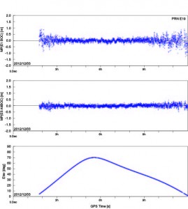


 The advanced features of the TurboRogue may well have been key in AOA receivers being used for a large number of ground reference applications, including Monitor Station Receivers for the U.S. Air Force GPS Operational Control Segment (OCS).


