Several weeks ago I attended the Esri Federal Users’ Conference in D.C. Not surprisingly, the conference was opened by Jack Dangermond, founder and president of Esri. As with most Esri conferences, there is too much to cover in this short column, so I’m providing my highlights.
Jack opened the conference by presenting the Esri “Making a Difference” award. This year it was given to the Army’s Arlington National Cemetery (ANC) and “make a difference” they did! Shown here accepting the award from Jack is Kathryn Condon, the Executive Director and Major Nicholas Miller, the Chief Information Officer (left).
Several years ago you may remember the scandalous news reports of very poor management and almost total lack of accountability at the ANC. Countless burial plots were misrecorded, finding a burial location for visiting family members was tedious, and some tombstones were even found dumped in a nearby stream. Tracking and management was accomplished via hand-typed index cards and colored pencil annotation of paper maps. We GISPs knew instantly that GIS was the answer and fortunately so did the Army. Their solution was thorough and elegant.
The Army, working with GIS, Inc., spent several months collecting more than 250,000 point locations of grave markers across the 624-acre cemetery. They used Trimble handheld GPS units to record each tombstone to an accuracy of three inches. Additionally, a digital photo of each tombstone was taken and recorded in the database. The result is an online system called ANC Explorer, which displays GIS maps, aerial imagery and digital photos of ANC that visitors can use to navigate the cemetery. Additionally, family members who can’t visit the cemetery in person can do a virtual search and tour.
Jack’s Vision
Jack outlined his long-standing vision of where GIS is and where it is heading. Much of his vision in the past was just that, a “vision.” However, reality has caught up. He spoke of the turning point brought about by cloud computing. He used the term “GIS as a platform” where software such as ArcGIS Online is mashed with other systems to create a pervasive geographic system that enables countless applications. Web maps point back to authoritative data sources rather than carrying the baggage of large local databases. Lightweight, agile applications are extendable, interoperable and permit easy collaboration. As part of this, the emphasis is on web maps as the new medium. He stated that web maps are simple, powerful, and cost effective for collaboration and integration. ArcGIS is the platform enabling this with three components: applications, content, and infrastructure.
To make all this happen, Esri is spending considerable time and effort not only on the technology, but to assemble extensive authoritative content. This is the big difference between Esri and Google. Google has changed how we all view computer mapping, but as many of us have learned over the years, Google is not necessarily an authoritative source. By its own admission, Google’s purpose is to attract users and drive them to advertising. They have no desire to become the world’s GIS expert. Esri on the other hand is working toward that goal. One example supporting this effort is Esri’s Landscape Analyst, which is being released this month. Similar to Community Analyst, designers can develop maps based on a variety of authoritative public data sets related to land use, land cover, pipelines, transmission lines, imagery, and many other features. The interesting aspect of Landscape Analyst is that more than 30 selected data sets can be used, downloaded, and incorporated into local applications.
Another announcement that caused a buzz was the free availability of DigitalGlobe World Imagery. The new update includes 30-cm imagery for the continental United States down to 1:1,000 scale, and 60-cm imagery for large parts of Western Europe down to 1:2,000 scale. Throughout the year, Esri and DigitalGlobe will grow the coverage with more than 100 million square kilometers of updated high-quality imagery, making it one of the most detailed free basemap services available.
CityEngine
For those of you interested in 3D GIS, CAD, BIM models, Voxels and visualization, CityEngine seems to blur the lines between each and merits a serious look. CityEngine was demonstrated during the plenary session, and is clearly a very fast and easy-to-use 3D modeling environment. It combines rapid 3D model creation from 2d GIS data, similar to Google SketchUp with serious database connectivity in a procedural-based environment.
Although I personally haven’t worked with CityEngine, the demos are impressive. See a video demo. CityEngine integrates standard file formats, including Collada, RenderMan, Google Earth, SketchUp, Wavefront, 3DS, Autodesk FBX, and WebGL. The CityEngine models can be viewed in ArcScene and WebScene. An interesting capability that could be very valuable for public meetings is a slider bar that can show inside/outside or before/after images.
One word of caution that I learned working with first responders is the use of textures or cloned images to create 3D models. Previous work I did with Pictometry and PLW Modelworks highlighted the difference between a representation of a 3D scene and use of actual geo-registered imagery. PLW builds 3D models that are “photorealistic” and “photo-accurate.” The models are built from imagery and each building is draped on each side with the actual measurable image of the building. As you can imagine, it’s important that a window shown 5 feet above ground is actually there and not just a graphic. If occlusions block some portion of the image, PLW makes no attempt to fake the image. It instead shows a no-data area that looks like a black shadow.
Note this example. The “shadow” is really a no-data location of the image.
Social Media
A pervasive topic that was part of numerous sessions and Expo exhibitors was social media and big data. The integration of this real-time data with GIS data and analytics is proving to enhance both, and its use is growing. There was a powerful example shown in the plenary session using Topsy technology. Topsy uses complex algorithms to do expert searches on thousands of tweets to discover information based on keywords or terms. The search ranks results based on topical focus and geography. Since only 1 percent of tweets are explicitly geotagged, Topsy developed machine learning methods to infer an author’s location, using features such as regular references to landmarks or events. By doing so, it claims to have high-confidence geographic information for more than 90 percent of tweets. The company demonstrated the benefit of plotting real-time tweets about power outages as a second, validating source of data during Hurricane Sandy.
Several exhibitors showed social media exploitation tools that were equally impressive. TerraGo demonstrated GeoXRAY, a system that combines GIS data with social media discovery and exploitation tools, brought together into a GeoPDF that can be used off-line in local collaborations by non-GIS users.
Other exhibitors were using social media for intelligence applications, financial analysis, and business and marketing applications, with a dizzying array of claims. My personal observation is that the social media environment is like the “Wild west.” Similar to the early days of GIS, there are competing products, repackaged data, and capabilities with overlapping systems. It will take a while to sort it out, but this is too important a topic to take lightly. Look for more information in future columns as I get educated.
It’s been a long time coming. With the capability to make a position fix from four signal-broadcasting satellites, we can now say that Galileo has truly arrived. Of course, this is only one of many milestones (excuse me, kilometer markers) along the way, a trajectory that could be bounded at 23 years and counting, or possibly longer. Let’s not forget, GPS had an extended gestation period of its own, as did GLONASS; BeiDou appears to be maturing a bit faster.
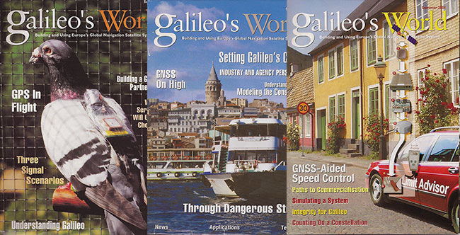
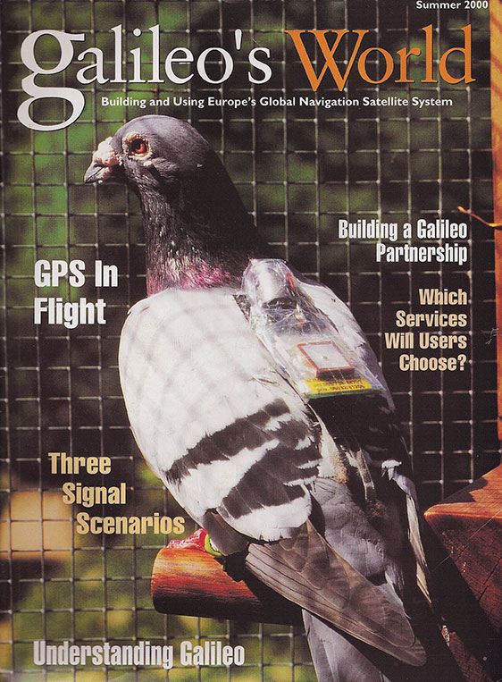
My acquaintance with the system began in July 2000, when I joined the staff of GPS World and received my first assignment, editing an article about GPS-bearing carrier pigeons in the sister publication Galileo’s World, from founding editor Glen Gibbons. We published Galileo’s World quarterly from 2000 to 2002, chronicling the ups and downs, forward steps and back, of the European GNSS. Unless you counted EGNOS — really telecom satellites with a piggyback SBAS payload — Galileo had no space vehicles as yet, but did encompass plenty of political and financial maneuvering, rhetoric, market projections, international negotiations, and technical blueprints. In short, the stuff of news. For application stories in the magazine, we filled with European uses of GPS, all of which would eventually integrate Galileo as well.
In 2002, a UK-based travel agency of the same name began to assert its legal possession of the name Galileo, and sent a cease-and-desist shot across the bows to the corporate ownership of the two magazines, and to the European Union. The EU felt it had sufficient legal clout or standing of some kind, for it neither desisted nor renamed its space program. But our counsel at the time instructed us to quietly fold up our tent and steal away. The impending battle wasn’t worth our stake.
And so Galileo’s World sadly ceased publication. Not for lack of interest, or support, or commitment. But because of someone else’s greed or turf belligerence in a completely unrelated market. Such is the way of the global economy.
We have covered every step of Galileo’s way, technically, economically, and politically, in the pages of GPS World. Occasionally we ponder calling ourselves GNSS World, or even PNT World. But the brand, like the satnav system it is named after, is just so strong, it would be foolhardy to walk away from it, at this point in time at least.
We continue to support European satnav progress at each successive stage. And so we say yet again: Welcome, Galileo!
Communications Security, Reliability, and Interoperability Council (CSRIC) Update
By Greg Turetsky
Many of us remember way back in 2001 when the FCC first announced E911 position reporting requirements for cell phones. That was a long time ago in many significant ways. Everyone had 2G phones and anxiously anticipated the arrival of 3G, and with it, data. Most people still had a landline at home, and used their mobile sparingly lest they overrun their monthly minutes. Roaming was very expensive and nearly impossible overseas. Very few phones had GPS, and people only turned it on when needed, as it significantly reduced battery life.
Now, in 2013, all of the technology has changed, but — not unexpectedly — the regulations have not. This is one of the reasons the U.S. Federal Communications Commission (FCC) created CSRIC.
The Communications Security, Reliability, and Interoperability Council’s mission is to provide recommendations to the FCC to ensure, among other things, optimal security and reliability of communications systems, including telecommunications, media, and public safety. The current council, CSRIC III, was born on March 19, 2011, and ended on March 18, 2013. Working Group 3 (WG-3), the E911 Location Accuracy group, has looked into both outdoor and indoor location accuracy issues to help the FCC shape new guidelines. I don’t think any of us would argue that given the current patterns of cell phone usage, the ability to provide a location indoors to a public safety answering point (PSAP) is something that is now needed, has significant value to the public, and would seem to lie within our grasp technically.
Working Group 3 is a fairly large group of experts from a wide variety of backgrounds. The actual list of participants is publicly available; what’s more interesting is the groups that they represent. Three main constituencies constitute the Working Group: the public safety community, the wireless operators, and the technology vendors. Each group has a slightly different goal, but they all worked well together to produce clear, unbiased reports that represent all the different members’ views in a way that lends more credibility to the overall report.
On March 14, the FCC released two reports created by WG-3: the “Indoor Location Test Bed Report,” and “Leveraging LBS and Emerging Location Technologies for Indoor Wireless E911 Report.” I will not review either document here as they are available publicly, but I will summarize the highlights of the reports from my perspective as a member of the location community and a concerned citizen, and attempt to predict where the process might lead next.
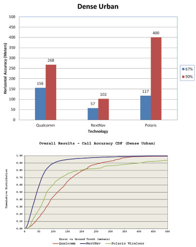
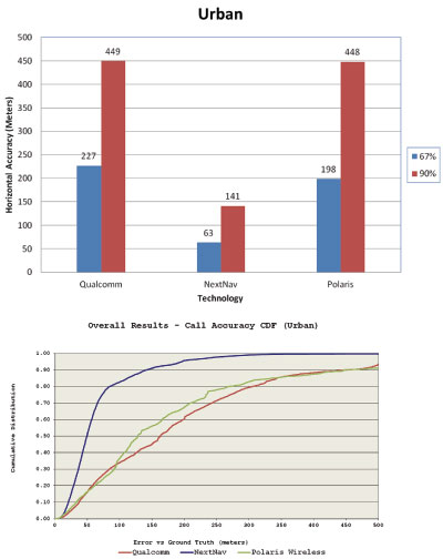
Figure 1. Indoor accuracy in the dense urban environment.
Test Bed Report. In my mind, two key results emerged from the Test Bed Report. The first was very positive: the test bed showed that there are technologies capable of yielding positions indoors, and their performance can be compared analytically. This may seem like a bland statement, but it carries a significant amount of weight with both the public safety community and the FCC. It acknowledges that the technology has evolved sufficiently such that in a test bed setting, we can gather and compare, in an apples-to-apples way, the performance of diverse technologies in terms of yield and accuracy. Similar to the LightSquared reports, this report focuses on ensuring that the data itself is valid. The interpretation of the data is far too politically and economically charged to be agreed on by all parties involved. It is a great accomplishment to concur on a methodology by which testing should be done, and to produce a set of results that can be given to the FCC with the entire council’s approval.
The second highlight from my perspective was less positive. The test bed originally had seven participants, but in the end only three completed the process. This indicates that there are even more candidate technologies for solving the indoor E911 problem — but for a variety of reasons, they were not ready for CSRIC testing at this juncture. Although having three choices is good, seven (or even more) would be better for the FCC to feel confident in its ability to create a new mandate with sufficient flexibility on implementation. There are clearly many ways to skin this cat technically, but we have to ensure that the test bed methodology allows as many as possible viable alternatives to be compared. There is clearly a gap between those technologies that are commercially available and those that can be used for E911.
Leveraging LBS. The Leveraging LBS Technology report also reached some interesting conclusions. The concept of leveraging LBS was actually how I became involved in the CSRIC. The underlying question that the FCC asked me to explore was “Why can a smartphone user can get a dot on a map indoors (usually with an uncertainty circle, no less), but no location information shows up on the PSAP screen if he makes an E911 call?”
As we dug into this problem, it became clear that this was less of a technology problem and more of a business/policy one. Quite a few large companies make money by providing that indoor location for various applications, but there isn’t any real money in E911 — although there are lots of liabilities. Also, many of these solutions are proprietary either to the phone, the operating system, or the application, while an E911 solution would need to be standardized across all of those as well as different carriers.
Figure 2. Indoor accuracy in the urban environment.
Conclusion. The FCC has received two reports with similar conclusions: We have come a long way since 2001, but we might not be there — the indoor E911 promised land —just yet.
There is still more to come, however. Therefore, many participants and observers hope the work of the current CSRIC will lay the foundation for a rational conversation about indoor E911 right now, and still be around to allow for future improvements. We have recommended that the test bed be maintained so future results can be compared with current ones. At issue is the funding source for the test bed. The FCC has announced the coming of a CSRIC IV, but has not released any further details. It is certainly the hope of WG-3 that the work performed to date to establish and validate the test bed will be available for use by future technologies as they mature.
Locating emergency callers indoors is a critical capability that we as society must address — not for the callers’ convenience, but for their safety and or public safety generally. The problem has technical, commercial, regulatory, financial, legal, and public safety facets to it, making it a very complex issue.
I should also note, that although E911 is a U.S. regulation, the problem of indoor location is under scrutiny in nations all over the world. I earnestly hope that all sides can continue working together to find a solution that can be implemented for the benefit of everyone.
Greg Turetzky is senior director, CTO Office, for CSR. He served on the CSRIC Working Group 3 LBS Subgroup. He will participate in a April 16 GPS World Webinar on this topic. Registration is free.
It’s an interesting and perhaps unanswerable question, whether governments ever truly listen to the voice of the people, and act accordingly. That premise gets another test in a GNSS setting, in Hawaii next month. An April 26 full-day session of the International Committee on GNSS (ICG) Interoperability Workshop will give those who design and build GNSS receivers a forum to offer their best advice to signal providers — BeiDou, Galileo, GLONASS, GPS, QZSS, and IRNSS are mentioned, as well as unspecified others — about how to achieve optimum interoperability benefits for their customers. “ Providers who have not finally decided on new signals will greatly appreciate your recommendations,” according to session organizer Tom Stansell, acting under the auspices of the ICG Working Group on GNSS Compatibility and Interoperability (WG-A).
The questions that candidate speakers are asked to address (given further on in this column) read like a primer on modern signal design, and suggest the complexity of issues dealt with at this very high technical level. The depth and level of detail at which the session organizers seek input reveal — what? That such issues are truly not yet determined by U.S., Chinese, Russian, and European system operators? This is impossible to know, outside government circles, and could easily be doubted by cynical minds. Yet the organization of such a workshop hints that at least some, if not many, such delicate matters remain in flux and under discussion.
The organizers seek three speakers each in four main topic areas. They emphasize that they are trying to involve only those who design GNSS receivers, not users, service providers, or product integrators.
High-Precision Code is for products with sub-decimeter accuracy that use wide area correction signals such as from OmniSTAR or StarFire.
High-Precision Phase is for products with sub-cm accuracy that use terrestrial correction signals to resolve carrier phase ambiguities.
Medium Precision is for products with sub-50 cm accuracy, which often are single-frequency receivers using local correction signals.
Consumer Applications are for chipsets embedded in consumer products.
If you want to participate, in person, by Internet, or by recorded PowerPoint presentation, you can contact the workshop organizers via GPS World magazine, by emailing [email protected]. Please indicate the topic that best fits your presentation. If you are not selected to speak, you are welcome to submit a paper or presentation that will be given to each signal provider.
Specific questions that candidate speakers are asked to address include:
Supported applications: What types of applications do your receivers (or receiver designs) support?
Increase in noise floor: Do you see a threat to GNSS receivers due to many more GNSS signals centered at 1575.42 MHz?
Whether you see a threat or not, do you prefer all new CDMA signals at L1 to be centered at 1575.42 MHz, or have some of them elsewhere, e.g., at 1602 MHz?
Given that most GNSS providers plan to eventually transmit a modernized signal at 1575.42 MHz, what is your long-term perspective on whether you will continue to use C/A? Why and How?
CDMA and FDMA: Once there are a large number of good CDMA signals, will there be continuing commercial interest in FDMA signals?Why or why not?
Compatibility: Do you prefer signals in different L1 frequency bands for interference mitigation rather than at one center frequency for interoperability? Why?
What to do about misbehaving signals: If a satellite’s signals do not meet quality standards, should they:
Be set unhealthy?
Transmit with a nonstandard code?
Transmit with reduced signal power (reduce interference)?
Be switched off?
What combination of the above?
To assure only good signals, should GNSS providers agree on minimum international signal quality standards and agree to provide only signals meeting the standard?
E5a and E5b: Given that L5/E5a will be transmitted by most GNSS providers, do you intend to use the E5b signal? If so, for what purpose?
Frequency steps: For your applications, are small satellite frequency steps (Δf) a problem?
If so, what interval between frequency steps and what Δf magnitude would be excessive?
Interoperable use: Assuming signal quality is acceptable from every provider, would you limit the number signals used by provider or by other criteria? What criteria?
Is having more signals inherently better or do you think there should be a limit?
Will the marketplace force you to make use of every available signal?
For best interoperability, how important is a common center frequency? How important is a common signal spectrum?
Another common open-service signal: Will you provide tri-lane capability in the future? Why?
If so, do you prefer a common middle frequency or the combined use of L2 (1227.6), B3 (1268.52), and E6 (1278.75) if B3 and E6 open access is available?
Would you prefer a common open signal in S Band? In C Band? Why?
Precision code measurements: Does a wider satellite transmitter bandwidth help with multipath mitigation?
What minimum transmitter bandwidth would you recommend for future GNSS signals in order to achieve optimum code precision measurements?
Added GNSS or SBAS messages: Would you recommend GNSS or SBAS services provide interoperability parameters:
System clock offsets
Geodesy offsets
ARAIM parameters
Others
Should they be provided by other means so as not to compromise TTFF or other navigation capabilities?
Signal coherence: For your applications and for each signal, what amount of drift between code and carrier over what time frame would be excessive?
For your applications and for two or more signals in different frequency bands, e.g., L1 and L5 (when scaled properly), what amount of relative drift in code and carrier between the signals would be excessive?
Spectrum protection: Should the international community strive to protect all GNSS signal bands from terrestrial signal interference?
System geodesy: Do the current differences (~10 cm) in geodesy pose a problem for your users? Why or why not?
If geodesy differences are a problem, what is the preferred method of compensation:
Published values (e.g., on websites)
Satellite messages
System time: Do you want each system to cross-reference the other’s time (e.g., with a GGTO type of message) or compare itself to a common international GNSS ensemble time? To what precision?
Will your future receivers calculate a time offset between systems based on signal measurements or use only external time offset data?
What is the preferred method of receiving time offsets: Satellite messages, Internet messages, or internally calculated?
The timed agenda for the April 26 meeting follows, showing both Hawaii Standard Time (HST) and Coordinated Universal Time (UTC), provided because some presenters will speak from remote locations using GoToMeeting over the Internet. Another option for presenters is to provide a PowerPoint file with embedded audio.
HST/UTC Topic Presenter
9:00/19:00 Welcome and Introduction Working Group Co-Chairs
A Constellation of 18 by 2015, Rising to 26 by the End of That Year
An Interview with Paul Flament
Paul Flament is the European Commission Programme Manager and Head of the EU Satellite Navigation Programme Unit.
A Belgian civil engineer specialized in telecommunications, he previously worked for 11 years in the European Space Agency, for space missions control centers and for the design and development of telecommunication satellites. After obtaining a master’s degree in European Studies, he joined the European Commission in 1998.
On the occasion of this special Europe/Galileo issue of the magazine, he speaks to GPS World readers regarding the present and promising future of the European GNSS.
Alan Cameron (AC): Can you recap for us briefly the upcoming satellite launch schedule that will take Galileo to Initial and then to Full Operating Capability?
Paul Flament (PF): It’s very simple. The first two in-orbit validation satellites were launched in October 2011, the next two on October 12, 2012. Satellites 5 and 6 will be launched in September of this year, aboard a Soyuz launcher from Kourou, and numbers 7 and 8 will follow in December.
Then, in 2013 we will see three Soyuz launches of two satellites each. We do not have the precise launch dates yet, but they are likely to be in April, June, and September. In December 2014, we expect to have the first launch using the Ariane 5 launcher, which is capable of deploying four satellites in one go. This means that by the end of 2014 Galileo will have deployed 18 satellites in orbit.
In 2015, there will be two Ariane 5 launches, one in the middle of the year, one at the end, each carrying four satellites. This will bring the total number of satellites to 26 by the end of 2015.
I am doubly confident of this constellation deployment schedule. First, at the technical level: The European Commission (EC) together with the European Space Agency (ESA) is following very closely all the industrial activities. The satellites in production now are with OHB. We have people in Bremen, where the OHB facilities are located, following this very closely. If there are technical issues, we take them up straight away with those concerned, the moment they appear. We also have monthly meetings with Jean-Jacques Dordain, the director general of ESA, and we make a careful tour of all the dates and conditions.
Secondly, there are no unknowns from the budget point of view. Except for the cost of the Ariane 5 launchers, the costs of deployment are already covered. And the EU’s member states have agreed on a budget of €6.3 billion for the next seven years. Budget should not be an issue.
Just recently, on March 12 of this year, we were for the first time able to calculate positions with the four Galileo satellites already in the sky. They pass overhead every so often, depending on geometry of orbit. This is an important technical milestone, even if this does not provide you a service as such. It demonstrates that the capability is there and that the mission part of the system works.
In terms of services, we want to be able at a certain point in time to start offering a guaranteed service. Our objective is October 2014. We will then have a constellation of 14 satellites. On the basis of that constellation, taking some margins, we will guarantee a minimum service of eight operational satellites. That service, in combination with GPS and other systems like GLONASS, will be something that users can start counting on. We will guarantee that at least eight satellites will be in operation from that moment onward.
We will probably translate this number of satellites into a performance-level guarantee. But for the moment it will be based on the number of satellites.
The fact is that we are populating the constellation, and very quickly we will have 26 satellites in orbit. That leads us to the Initial Operational Capability (IOC) phase: With those 26 in the sky we will guarantee a service based on 22 operational satellites.
The target constellation is one of 30 satellites. We don’t know yet for sure when this will be achieved. That will depend on when the last batch of satellites are ordered, and we are still discussing that. But we have an obligation to have deployed 30 satellites by the end of 2020. Then we will guarantee a service based on 24 satellites, with two spares per orbital plane.
AC: What is foreseen as the market readiness to adopt and use Galileo at that time? What companies are taking the lead in designing, manufacturing, and selling combined GNSS receivers?
PF: We believe that market trends go towards multi-constellation receivers. We already see that in some iPhones with GLONASS capability. We already see in the professional market segment that there are some companies providing Galileo capabilities, taking advantage of E1 and E5 for GPS and Galileo.
In the mass market, we also believe many companies will start to build up the multi-signal capability. Companies like STMicroelectronics are working on that. I have asked the European GNSS Agency (GSA) to provide figures. Out of a list more than 60 receiver manufacturers, at least 50 percent of them have at least one product that incorporates European Geosationary Navigation Overlay Service (EGNOS) capabilities. Of those same 60 companies, 30 percent already also have products incorporating Galileo capabilities: STMicro, Septentrio, NovAtel, Leica Geosystems, IFEN, Japan Radio, and others.
We believe that it is important to have continuous interaction with receiver manufacturers so that they understand the benefits of Galileo. EC Vice President Antonio Tajani is devoting a lot of attention to that. We build Galileo, but we do it for users. We have to make sure manufacturers understand the benefits. Discussions with them started in December in London when Mr. Tajani met with a set of CEOs of receivers manufacturers. He promised to meet with them every six months. We are also meeting with them on March 19 to provide information on calendars.
AC: What other European Commission programs will rely on initial or full Galileo capability to fulfill their mission?
PF: As of today, there is no obligation to use Galileo, no mandatory regulation imposing the use of it. There are some initiatives, like the Intelligent Transport Directive, which recommend but do not impose making use of EGNOS and Galileo. Or eCall, which in case of a car accident automatically contacts the rescue services. This will be required in all new cars starting 2015. These systems rely on satellite navigation for positioning. We also have digital tachography to measure the times of driving and rest of truck drivers. This will become a requirement as from 2018, and also relies on satellite navigation.
We also see initiatives by member states to put in place GNSS-based road-pricing systems. Germany has taken a lead in this. The European Union (EU) is trying to harmonize these road-pricing systems across national borders, with programs like Eurovignette and the Interoperability Directive.
In other modes, like aviation, you already have EGNOS. With landing procedures in place based on EGNOS, the system has become a reality.
In Europe we have the common agricultural policy, providing subsidies to farmers. As these are based on field sizes and crops, they need to be controlled, and using EGNOS and Galileo will help achieve more precise measurements.
AC: The Galileo Open Service Signal In Space Interface Control Document (OS SIS ICD) Issue 1 is described as being “subject to evolution.” Can you predict when a further iteration (Issue 2) will appear, and what changes it may contain?
PF: The present version of the ICD is still applicable. It correctly reflects the structure of the messages broadcast by Galileo. The statement you quote refers to the evolution of the document because as you remember there has been a debate about a safety-of-life (SOL) service that is multi-constellation and multi-regional. Since the initial concept of SOL on Galileo was changed in the last two years, some capacity onboard the satellites has been freed. We would like to use that for something else, keeping the backward compatibility for receivers. This will allow us to put in place, for example, a mechanism to improve the tracking performance and availability. Also authentication and higher accuracy for professional markets could be implemented, while maintaining the options for future advanced receiver-autonomous integrity monitoring (RAIM). That explains why we are still working on the evolution of the document. The next version of the ICD will be published in due time.
AC: Can you talk about progress towards increasing the EU share of the GNSS global market — currently 20 percent, but with the objective to reach 33 percent, as in other high-tech sectors? How might this be done?
PF: It is important for us in building Galileo that users benefit in having a second constellation. Satisfying users is the key. It also gives us some sort of independence from GPS, which would otherwise be the sole-source GNSS in the world. We would like our European companies to be more proactive and not to be limited to 20 percent share of the market. Everyone would.
We have our traditional research programs, like the Seventh Framework Programme (FP7). The next installment of the EU’s research programs will be called Horizon 2020, and it will make available budget devoted to the development of applications, receivers, and so on. Whether that will allow European companies to gain market share will depend on their proactivity, their innovation, and market-oriented strategies. That is their responsibility.
We are also active in things like the Galileo Masters, which tries to help small-to-medium enterprises (SMEs) who have good business ideas, young entrepreneurs or scientists with good GNSS-related innovations.
On top of that, we are starting studies to see how we can secure the market uptake of Galileo, not simply to help European industries, but to see that manufacturers and downstream applications developers understand the benefits of Galileo. By the end of the year, we should have created a better understanding by manufacturers and users of the full potential of using Galileo.
AC: Are there any other issues or concerns that you would like to bring to the attention of GPS World readers and the global GNSS community?
PF: I would like to briefly focus on EGNOS. For us it is important that this service will stay for a long time. We promised this to the aviation sector. The EU is finalizing its budget for the period 2014 to 2020, and this will allow us to continue to operate and improve EGNOS. Our objective is that it will augment Galileo as well as GPS, using the dual-frequency approach. That’s a real plus at the regional level for Europe. Its main customer will remain the aviation sector, although it is also widely used in precision farming, tracking and tracing, and so on.
Secondly, we are working on the continuous evolution of the system. We all know that satnav is an evolving domain. It takes time to build satellites and to improve technology. The Mission Evolution Road map that has been developed by experts will be presented to member states later this year.
Finally, we will be organizing the annual European Space Solution conference in Munich in November this year, and in mid-2014 in Prague. We are also hosting the International Committee on GNSS (ICG), which will take place in Prague in November 2014. For us, the location in Prague is symbolic since the European GNSS Agency (GSA), which will be our exploitation entity, is also located there.
This year’s Mobile World Congress, held late last month in Barcelona, featured the world’s largest mobility conference. While there was not a lot of strictly location-based services news, connected vehicles seemed to be the big deal. Ford and GM both made important announcements, sending a signal that wireless information and connectivity is here to stay in a vehicle — and location will be a big part of the growth. On the downside, MWC is becoming a mini Consumer Electronics Show with hotels gouging attendees, long cab lines, heavy traffic, expensive meals and long commutes to the show for those wanting to pay less than $400 a night for a room. Sounds like Las Vegas in January.
By Kevin Dennehy
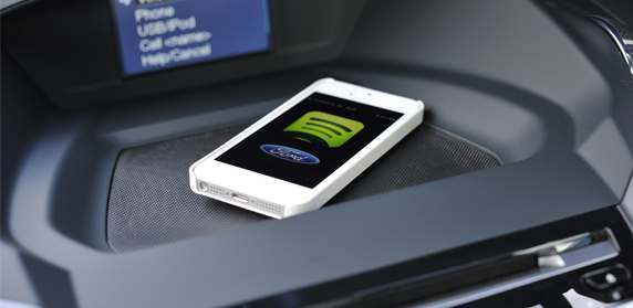
The recent Mobile World Congress, held at Barcelona’s Fira Gran Via conference center, featured big connected vehicle announcements from Ford and GM. Ford announced a slew of deals, one partnering with Spotify to make Spotify Premium available through its Sync AppLink. GM’s big announcement is that its OnStar safety, security and navigation service will use AT&T Mobility’s network for LTE modules in 2014.
Ford’s partnership with Spotify gives drivers access to millions of tunes on the road.
Industry observers believe that GM’s announcement indicates the new AT&T deal could give the connected vehicle market a big boost as the units will go into most cars, including entry-level vehicles. Wireless carriers have indicated that transportation remains one of the key vertical markets they are aggressively getting in to.
AT&T pulled a big coup as GM uses Verizon Wireless for its OnStar service. However, published reports indicate that the company has been disconnecting subscribers who are not currently using the service. Verizon said it had lost 490,000 connections in late 2011 — and said the losses were due to decline in telematics customers.
There is no word on whether 2012’s $617 million purchase of Hughes Telematics had any effect on the Verizon-GM relationship.
Overall, OnStar, which costs $18.95 per month, has more than 6 million customers worldwide.
A concern with connected vehicles, and this is an issue that has been around for the past few years, is that automobile manufacturers do not believe the vehicle isn’t the new mobile phone — though some carriers believe it will be. Another concern is the form factor itself — what is better? What will the winner be? An embedded system or a system that integrates with a user’s smartphone?
Not to be outdone by GM, Ford also said its 2104 Ford Ecosport will feature AppLink capabilities. The company also said it would be offering, in Europe, applications from Kaliki, Glympse and Aha. Ford says it now has 2,500 folks registered in its developer program — doubling the numbers from last month.
Ultimately, many analysts say that two major market issues will need to be resolved for the connected vehicle segment to take off. One is what will consumers want? The other is standardization — will every vehicle have the same system in use? Already Ford and GM seem to have differing technology and business models for this market.
Is Mobile World Congress Getting Too Big to be Useful?
With more than 72,000 attendees this year, which is a little more than half the size of the gigantic Las Vegas-based Consumer Electronics Show, is MWC becoming too big and less focused for wireless application developers, LBS companies looking to partner and other location company entities?
Does this sound like a mini CES? The Fira Grand Via had 1 million square feet of exhibit space, 1,700 exhibitors and 72,000 attendees from 200 countries. All of this is puzzling for a conference that had no Google (the company had a big exhibit last year) or Microsoft.
In addition, there were no huge announcements — even the connected vehicle news would be mid-level news at CES. Does it say something strange about a big wireless show when your main news is connected vehicles?
Deciding not to get lost in the hugeness of a big trade show, most of the wireless companies and handset manufacturers choose to make their own product and deal announcements at their own branded shows or independent press conferences. Outside of a handset having LBS capability rolled out, and companies saying they are rolling out capability in European nations, there wasn’t much location-specific news.
With no big indoor position news at MWC, does that spell a struggle for the new technology and potential gigantic market? Many publications, including this one, has touted indoor positioning as one of the technologies that will spur LBS’ market growth.
A few smaller companies did display indoor positioning products at MWC. Rx Networks rolled out its Xybrid Synchro that allows a device to self-located without an active data network connection. The company also rolled out a cloud-based GNSS systems that allows users to determine a location even when weak location signals are available, the company said.
Another indoor positioning company, Insiteo, showed off its products that work on iOS and Android devices to allow users to find booths at MWC. The company says product finding, location-based marketing and data mining are all applications for the platform.
In other Mobile World Congress news:
Telit launched m2mLOCATE, a feature that adds Cell-ID location for a range of its cellular connectivity modules. The company uses RX Networks’ XYBRID RT service, a database that encompasses 40 million cell-IDs.
CSR demonstrated its Location Services Platform, which features context detection and user self-learning to deliver indoor and outdoor location for the consumer and enterprise markets. The company says the platform has an indoor accuracy of less than 10 meters.
TeleCommunication Systems shopped its LBS suite of services at MWC to both enterprise and consumer companies. TCS recently deployed four new mobile operators on its hosted cloud LBS product. The company says it offers revenue-producing branded and private-labeled applications for navigation, hyper-local search, enterprise and family locators.
ALK Technologies, now owned by Trimble Navigation, said its CoPilot GPS navigation apps for smartphones and tablets will be available for Windows Phone 8 and Windows 8. The company said it’s always been high on Microsoft’s mobile products, as CoPilot was originally developed for Microsoft’s Pocket PC. CoPilot features voice-guided GPS navigation, turn-by-turn guidance, trip planning and automotive-grade street maps, the company said. The unit’s live services include Yelp, ActiveTraffic, Wikipedia and Google Search.
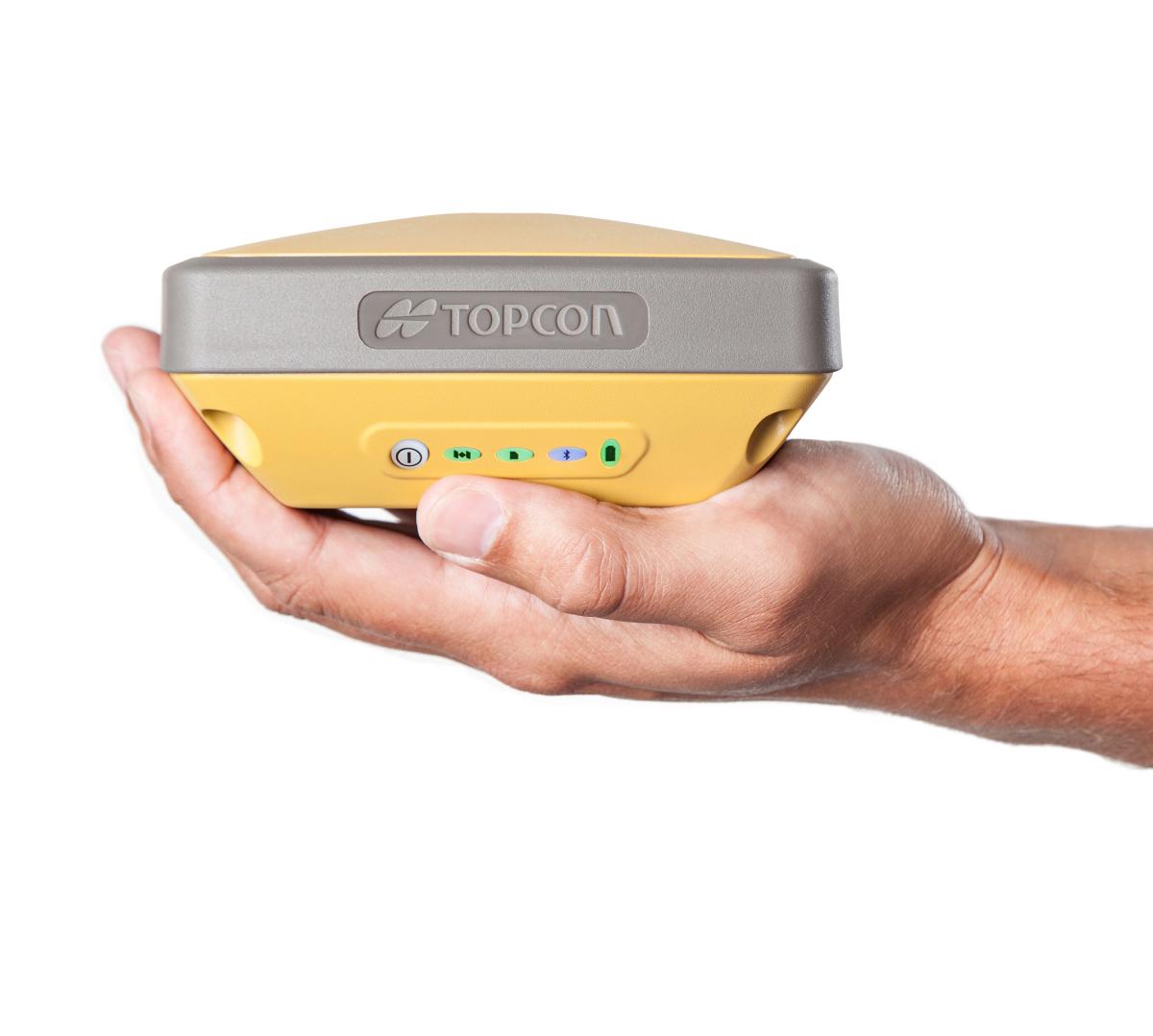
Wow, if one counts the number of new RTK GNSS receivers introduced in the past ~six months, it’s impressive. If you’re in the market for such a GNSS receiver, this is good news for you. More competition in the product and distribution side of the equation usually means better products and better service for the consumer. While Trimble, Leica and Topcon still dominate the majority of RTK GNSS receiver sales in North America, it’s pretty clear that others are eating away at their market share, and most of the new competitors don’t even design their own RTK GNSS receivers! The high-precision user community has more choices for high-performance RTK receivers than ever before even though there are only a handful of companies capable of designing reliable RTK GNSS receivers:
Trimble
Leica/Novatel
Topcon/Sokkia
Hemisphere GNSS
JAVAD GNSS
Septentrio
Ashtech (owned by Trimble)
Navcom Technology (owned by Deere & Co.)
Some of you may think that I should include “consumer” GNSS chipset designers like GlobalLocate/Broadcomm, SiRF/CSR, u-blox, NVS Technologies, etc. While some of the engineers at consumer GNSS chip companies clearly have the knowledge (and experience in some cases) of RTK design, none of these chipsets are integrated into commercial RTK products. Yes, I know some of you have “made RTK work” with consumer GNSS chipsets, and I think that speaks volumes about where RTK capability will end up, but it’s not quite there yet with respect to a reliable commercial implementation.
Regardless of consumer GNSS chipsets, the multi-constellation, multi-frequency RTK GNSS receiver landscape is changing quickly, even before the deployment of the new L5 signal and Galileo as I’ve written about previously (Why the Price of Precision Receivers Will Drop). This is because of the proliferation of RTK GNSS receiver “boards” such as the Trimble BD series, Novatel OEM series, Hemisphere GNSS P series, and Septentrio AsteRx series. System integrators like Altus, Geneq, CHCNav, Stonex, FOIF, Carlson, etc., are scooping up these proven receiver boards and designing their own systems around them.
There are more RTK GNSS system integrators in China than any other geographic region in the world. It makes sense because the Chinese market for RTK GNSS receivers is larger (much larger) than any other market in the world. Even though you don’t see many Chinese-made RTK GNSS receivers sold in North America (you do see them sold in Africa, Europe and South America), they sell a huge number of them within China. I would even go as far as to say that the North American market is likely considered a “leftover” market since the North American RTK GNSS receiver sales volumes are so low in comparison. In other words, North America is such a small market for RTK GNSS receivers, it’s not worth the marketing/selling effort it requires. That said, some companies, like CHCNav, are ramping up their marketing and selling efforts in North America.
To put it in perspective, let’s take a look at some of the new RTK GNSS products (and services) introduced in the past ~6 months (in alphabetical order). I’m sure I’ve left some out because there are so many on the market, but this gives you an idea of the broad range of RTK GNSS receivers available. Again, these are products introduced just in the past ~6 months.
Key benefit: 5cm (horizontal RMS) real-time correction service delivered via IP (Internet Protocol) as an alternative to delivering via satellite communications.
Key benefit: World-wide, real-time 4cm GNSS correction service delivered via satellite.
Looking at this list, there are two key trends:
RTK GNSS receivers are becoming smaller. Moore’s Law, or a GNSS version of it, is definitely in effect.
The price of RTK GNSS receivers is falling, as low as US$7,000 (retail price) for a full RTK GNSS receiver in North America and likely less than that in other parts of the globe.
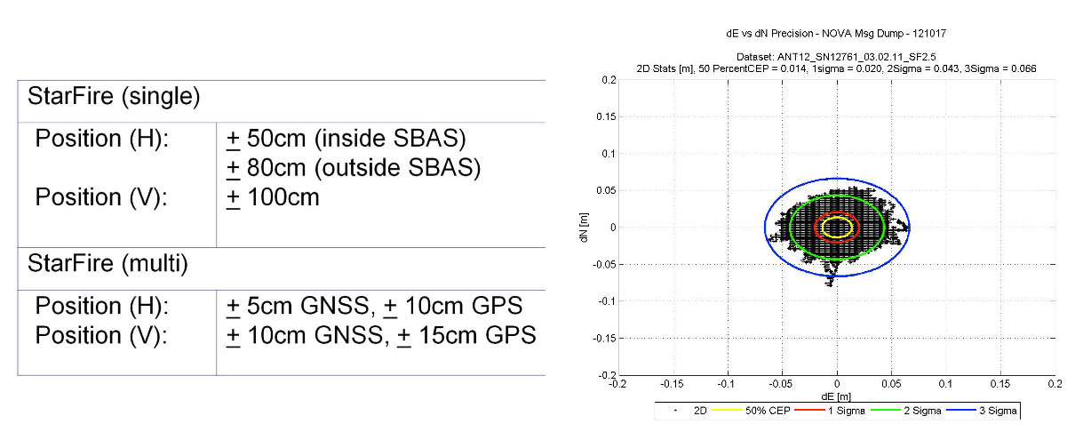
Another clear trend is the advancement of global GNSS augmentation services (OmniSTAR, StarFire, Terrastar, Trimble). RTK networks are great when you have access to them, but in many places of the world, RTK networks aren’t available or there isn’t a data link (wireless network) available to receive corrections. This has created an opportunity for satellite-based (and Internet-based) global correction services. Whereas OmniSTAR (serving the agriculture and mapping markets) and StarFire (serving primarily the agriculture market) have been long-term players in this market, Terrastar recently announced its entry into the market and Trimble (who also owns OmniSTAR) announced its new RTX service.
The advantage of satellite-based correction services is that you can receive them virtually anywhere in the world as long as you have a clear view of the sky. The disadvantage is that the initialization time it takes to achieve the stated real-time accuracy (<10 cm) is up to one hour if you aren’t starting on a known point. The addition of GLONASS helps reduce the initialization time, but it’s still much longer convenient than RTK initialization due to the sparse network of reference GNSS receivers used.
Furthermore, the accuracy provided by the satellite-based correction vendors isn’t as good as RTK. OmniSTAR and Terrastar advertise 10-cm (horizontal 2DRMS) real-time accuracy. StarFire advertises 5-cm (horizontal RMS, as opposed to 2DRMS values given for competing services) real-time accuracy, and Trimble RTX advertises 4-cm (horizontal 2DRMS) real-time accuracy. RTK accuracy is solid at 2-cm or less.
Lastly, in order to access satellite-based correction services, GNSS receivers must be specifically designed (additional hardware is required), so the reality is that few receivers on the market are capable of utilizing these services. But, if you’re performing mapping work across a large geographic area where RTK networks aren’t consistently available and you don’t want the go through the pain of owning, maintaining, and setting up your own RTK base station, the satellite-based correction service is a solid solution.
For more information on these satellite and internet-based correction services, GPS World’s Tony Murfin published a detailed article this month entitled “Look, No Base-Station! — Precise Point Positioning (PPP)“. Tony offers some detailed insight into these services.
Nightmare on GIS Street: Accuracy, Datums, and Geospatial Data
Changing the subject a bit, but highly related to RTK GNSS receivers, is the subject of datums and geospatial data. Last month, I wrote an article for Geospatial Solutions that is a first in what promises to be a very interesting and complex discussion. I received quite a bit of email on the article with many good points made. If you think you know how to handle horizontal datums in a GIS environment, you might want to take a look at the article and follow the thread over the next few months. You can read the article by clicking here.
It used to be that professionals using precision GNSS applications had to go to the expense of buying, operating, and maintaining RTK base-stations and radio set-ups. Then L-Band corrections came on the scene and things changed. Most precision receiver manufacturers supply an L-band option for a nominal fee, and also sell PPP service subscriptions. There are now a number of PPP correction service providers offering higher precision, including a couple of new options.
As a quick overview — L-band is just like WAAS, but with privately owned assets, rather than provided by a state agency. WAAS focuses on high integrity and accuracy, while L-band corrections are largely more focused on providing accuracy to users. A geographically distributed ground network of base stations sends receiver data to one or more central processing facilities, which formulate wide area corrections. A number of uplink stations then send these corrections up to geostationary satellite transponders (time on a number of satellites is often rented, but L-band companies could also own and operate their own satellites), and the transponders transmit the wide area corrections at L-band frequency for reception by suitably configured user receivers. Users are able to buy subscriptions that enable them to receive corrections for a period of time — and that’s how the private L-band suppliers make money. The accuracy a user can achieve depends on the service, but anything from a few meters to a few centimeters is now possible.
Before WAAS was fully operation in the U.S., L-band corrections supplied by private companies were already available. It became possible to regularly get meter-level accuracies without base-stations, and it was clear that this could well turn into a major benefit for users. Operations like agricultural automation, asset tracking, mining, marine navigation, and others that could get by with a few meters of accuracy began to rely on L-band corrections. Geographic Information Systems (GIS) could even work without base stations, and vehicle tracking could determine which side of the road a truck was on. Then with expanding worldwide ground networks, more satellites and ever-improving clock and orbit algorithms, we started talking about corrections that gave us decimeter accuracies. That’s when PPP began to outpace WAAS for some applications requiring higher precision.
Never quite got the significance of why the original marine PPP companies were spinning off land-focused providers from their marine businesses, but the original marine correction providers now have successfully established “land-only” provider companies. It makes sense to have a supplier talk to you in marine terms if you’re running a shipping company, and for that provider to focus on providing higher integrity corrections to your shipping fleet. Land-based machine control, GIS and vehicle tracking outfits, on the other hand, want their own land-based support networks and don’t want to talk in marine terms. So we now have a number of providers supplying different sets of PPP corrections. It’s also possible that segment pricing for the different markets might have played a role in these spin-offs.
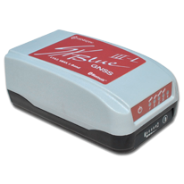
The granddaddy system would seem to be Fugro’s OminSTAR — whose services are now marketed by Trimble following acquisition of OminSTAR marketing rights by Trimble in 2011, while Fugro retained its marine services. OminSTAR HP, G2, XP and VBS services are available courtesy of a worldwide network of reference stations, data networks, carrier-phase measurements and sophisticated “clocks and orbits” correction algorithms which provide sub-meter thru 10-cm capability to users.
The OmniSTAR network.
And of course Trimble is also running its own RTX service alongside OmniSTAR. With a world-wide reference station network, and a number of concentrated regional networks, CenterPoint RTX is regularly achieving less than 4cm for users. RTX is available over regular L-band satellite and over internet. Overall an impressive PPP capability.
The CenterPoint RTX network, by Trimble.
Then NavCom — and Deere & Co, its parent company — fielded the StarFire system for both NavCom and John Deere customers, who not surprisingly use it mainly for agriculture. However, use of the system has grown since it was introduced in 1999 and currently around 10 percent of customers are in markets other than ag — in offshore, survey, construction, aerial, GIS, and government/military applications. The StarFire signal is available worldwide but NavCom offers two differently priced services: “Land Only” and “All Area” for non-ag applications. You have to have Navcom or John Deere equipment to be able to use it, but the network and the receivers come from the same people, so the system has been optimized for peak performance and there shouldn’t be concerns about third-party integrators or service providers.
In 2001 in collaboration with JPL, Real Time GIPSY (RTG) was combined with the existing StarFire clocks and orbits algorithms and a StarFire GPS 10-cm service was offered. Nowadays StarFire GNSS has evolved out of that original correction service and claims impressive 5-cm accuracies using its multi-constellation GPS and GLONASS corrections.
The Starfire GNSS network.
StarFire also uses over 80 reference stations with mostly GPS/GLONASS receivers providing carrier phase data for redundant processing and distribution by L-band transmissions over the Inmarsat satellite network.
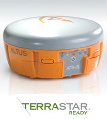
Then we come to the latest entrant into the land PPP business – TERRASTAR. The parent company Veripos has been around since 1989 and has been extremely successful in its marine business, going public in 2012 on the Oslo stock exchange. Veripos recently launched TERRASTAR to better address the land market for all the same good reasons discussed earlier. TERRASTAR provides two correction services: –M is meter level DGNSS and –D is a decimeter solution using both GPS and GLONASS. All the 80+ owned and operated reference sites around the world have dual-frequency GPS/GLONASS receivers, and there are plans to add Galileo and even COMPASS in the future.
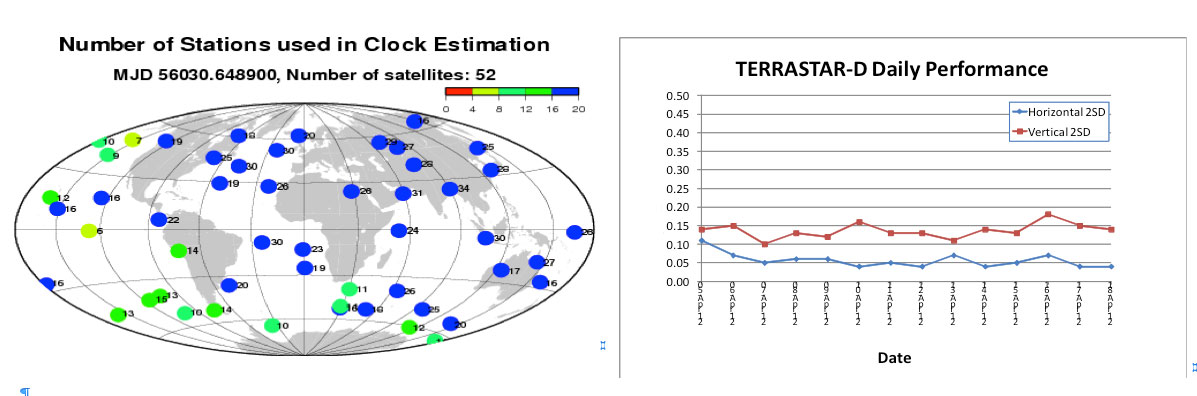
Dual-redundant processing and network servers ensure uninterrupted distribution of GPS and GLONASS orbit and clock corrections, enabling decimeter accuracy for users. TERRASTAR distributes corrections over all seven Inmarsat GEOs, providing most land users with redundant L-band visibility.
Correction quality and availability are largely dependent on the number of reference stations that track the same GNSS satellite. The figures below show the location of satellites at a given time and the number of stations simultaneously tracking those satellites. For the TERRASTAR ground network, there are often more than 30 stations tracking the same satellite. This makes for high-quality clock and orbit corrections, and TERRASTAR-D claims to provide consistent, stable horizontal 5-10 cm and vertical 10-15 cm performance.
The TERRASTAR network.
As a new player, TERRASTAR has yet to corner a whole bunch of customers, but it already has some significant customer applications. It “GEO-Gates” its corrections like other providers to ensure usage on land, but it extends coverage to land areas plus about 6 km beyond the coastline — termed “nearshore.” So TERRASTAR has been able to capture in-shore dredging and construction business in Europe that otherwise might have had to go to more expensive marine correction services.
In addition, a new customer is using TERRASTAR for airborne geophysical applications. There are also ongoing trials on excavators in road construction, on trains, in oil and gas, for GIS/surveying, and with integrated agricultural sprayer-control and harvesters. TERRASTAR plans shortly to offer a web-based e-Commerce System for users to control their subscriptions. TERRASTAR and Septentrio/Altus have long-term relationships for receivers/systems, and Septentrio and Altus also retail the TERRASTAR service.
So, just when you think you have a good picture of PPP, another option for users has started to show up. PPP over internet — or iPPP as Nexteq Navigation in Calgary, Canada terms their service – is designed to provide similar corrections as PPP, but over cellular phone or Wi-Fi connection to the internet, rather than over satellite. With single frequency GPS, Nexteq claims accuracies of around 50cm, and 10cm with dual frequency, although their T5 and T5A handhelds only currently support L1. Of course Trimble has had corrections over the internet for a number of years.
So its clear that PPP services continue to evolve and become more and more sophisticated to match the growing complexity of customer applications. And as achievable accuracies improve, we’re seeing use in higher precision applications which would have seemed impossible just a few years ago, where local RTK base-stations and radio links would have been the only way to go.
With several very capable sources to choose from, GNSS industry customers have several options to carefully assess and fit to their business. Each PPP supplier has specific advantages and features available to meet customer expectations. The market now appears to be large and specialized enough that its inviting for new entrants. And each new entrant seems to bring with them new twists and capabilities which sell their services. As a customer, it’s a good time to trial new precision applications with PPP.
It’s a streak. The Connected Car was yet again the most exciting emerging technology in the room, this time at the Mobile World Congress (MWC). The connected car service includes navigation, infotainment and location offerings. The big news in this sphere has come from General Motors, but more about that later. Do you remember the death of cellular digital packet data (CDPD)? Now it’s 2G’s turn. The 2G network used by many asset M2M tracking devices is going away. And Amazon is getting in Google’s face with a giant, well-oiled mobile ad network.
Beginning with 2015 car models, AT&T will replace Verizon Wireless as GM’s communications partner. Next year, GM plans to install AT&T LTE modems into many of its vehicles and Verizon will be the network behind GM’s OnStar service. The new modems will enable richer, faster content, including streaming video and radio.
The Connected Car squabbles. Should in-vehicle connectivity be controlled by a smartphone or by an embedded device? There are arguments on both sides. Ford’s forward-thinking connectivity choices have helped elevate what was a dowdy brand. “The last thing we want to do is take this [smartphone] thing that updates every 12-18 months and embed it into a car that has a lifecycle of at least 10 years,” asserted Doug VanDagens of Ford Motor Company. “Users are already paying for the data connection on their phone, and so they shouldn’t be assessed another fee for their car to access a network.” On the flip side, Glenn Lurie of AT&T raised concerns about software updates in a smartphone tethered scenario, in which a user might have to pay for data charges incurred by software updates that auto makers push to vehicles.
Vast market. No matter the approach, the connected car is a huge market opportunity. By 2020, Machina Research predicts that 90 percent of new passenger cars will have some sort of a connectivity platform and the market will reach $600 billion. There are concerns that in-vehicle service offerings may be too complex and could delay uptake. Drivers will want to pay one vendor for in-vehicle services and have pricing and billing options that are not complex.
Prepare for the death of 2G. AT&T plans to shut down its 2G networks by 2017. Verizon is planning to shut down its 2G and 3G EV-DO by 2021. The majority of small enterprises that track assets use 2G GPS modems. Many larger enterprises have been transitioning to 3G (HSPA) in this space. Companies that are considering M2M solutions may want devices that will work long into the future, and as the cutoff date approaches, customers will be increasingly reluctant to make purchases of 2G devices. LTE modems are currently about three times as expensive as 2G modems, which will put a dent in ROI calculations.
Amazon is joining the game. Amazon is rolling out a mobile ad network juggernaut. The mobile ads API, now in beta, enables third-party developers to integrate advertising into Android games and applications. Ad targeting options include GPS coordinates, gender and product floor prices. Android developers have struggled to make money through Google’s own storefront. The Amazon App store for Android has proven lucrative. For every $1 generated by Apple’s App Store for iOS, Amazon generates an average of $.89 per user and Google Play generates just $.23 per user, reports Flurry. Apple has been laying the golden egg, but Amazon knows how to sell and just may surpass Apple.
It’s smartphones. It has finally happened. This year, worldwide shipments of smartphones will squeak by feature phones shipments, predicts analyst firms IHS iSuppli and IDC. Falling smartphone prices and the rise of LTE networks have contributed to the growth in smartphone adoption.
Who were we talking about?Lissted analyzed more than 7,000 tweets about the Mobile World Congress sent by 619 journalists and bloggers and 419 media outlets. Nokia was tweeted about more than any other company, followed by Samsung and Android. Who will lead the hashtag race at CTIA?
A few months ago, many of you may remember that I wrote about an encounter with a rather well-known female journalist who, after listening to one of my GPS presentations, said something like this, “I came here today to learn more about GPS and so far all you have talked about is atomic reference systems…what the heck do those *&@# atomic clocks have to do with GPS…?”
I mentioned at the time how incredulous I was at the question, but that I answered it with a straight face. Now, while professional courtesy prevents me from ever revealing the name of the female journalist, I will say that she evidently started an uncomfortable trend. Much of my correspondence lately has concerned the connections between time and position and/or navigation and why we are so concerned about time.
I won’t bore my more sophisticated readers with GPS 101, or certainly not Time and Frequency Metrology 101, but I will tell you that I think we (this is not the royal “we” but includes all of us who work with and promote GPS on a daily basis) need to do a better job describing just how GPS works and more importantly how critical precise time and frequency is to position and navigation solutions, whether GPS is utilized or not. And I don’t have the time here to take up the argument concerning how important GPS is to our critical national infrastructure. Indeed, a topic and column for another time.
I am sure my time and frequency metrology friends and colleagues at NIST (National Institute of Standards and Technology in Boulder, Colorado) and USNO (U.S. Naval Observatory — read as UTC — home of Coordinated Universal Time and the Master Clock) would probably go about this differently. They tend to approach these problems strictly from a metrology viewpoint. While there is nothing wrong with that perspective, I hope to give you a more hands-on operational view of time and how it relates to position and navigation.
Here are a few quick Smithsonian facts, with commentary added, for those who want to visit and learn just what time has to do with GPS and navigation in general:
What: The Relationship Between Time and Navigation
When: Opens in April 2013.
Where: The Smithsonian’s National Air and Space Museum, Independence Avenue at Sixth Street, S.W., Washington, D.C.
Responsibility: “Time and Navigation — The Untold Story of Getting From Here to There” is being produced jointly by the Smithsonian’s National Air and Space Museum and the National Museum of American History. This is one of the few times, if not the first, that two museums have jointly produced a major exhibit of this importance.
Sponsors: The exhibition is made possible through the generous contributions ofNorthrop Grumman; Exelis Inc.; Honeywell; National Geospatial-Intelligence Agency; U.S. Department of Transportation; Magellan; National Coordination Office for Space-Based Positioning, Navigation and Timing; Rockwell Collins; and ION the Institute of Navigation. Note: The sponsors are listed in order of the amount they gave to present the exhibition, but it should be noted that ION was among the first contributors, making the museums’ decision to go ahead with the exhibit a more comfortable one. More on that and why it is significant later.
The USS Alabama.
Artifacts: (Don’t you just love the word artifact? Indeed, someone once told me, and not unkindly, that I resemble that word.) The time exhibition features 144 artifacts, drawn primarily from the collections of the participating museums. Highlights of the exhibition include a representation of a 19th-century ship from the U.S. Exploring Expedition; the first sea-going marine chronometer made in the United States; the submarine navigation system for the USS Alabama; a TRANSIT navigation satellite (a major naval predecessor to GPS); Wiley Post’s airplane, the Winnie Mae; and Stanley, originally from the Stanford University Racing Team and written about many times by yours truly in GPS World. Stanley is a robotic vehicle that can drive itself. Stanley is a 2005 Volkswagen Touareg, which has been considerably modified to navigate without remote control and without a human driver onboard. Stanley handily won the 2005 DARPA Grand Challenge (Defense Advanced Research Projects Agency), a robotic vehicle race. Stanley successfully navigated 212 kilometers (132 miles) across desert terrain and has had his (here we go, anthropomorphizing automobiles) own robotic exhibit at the Smithsonian since 2009.
An official DARPA photograph of Stanley at the 2005 DARPA Grand Challenge. Stanley, created by the Stanford University Racing Team, won the race.
Organization: The current time exhibition is organized into five sections: Navigation for Everyone; Navigating at Sea; Navigating in the Air; Navigating in Space; and Inventing Satellite Navigation.
Theme: If you want to know where you are, you need an accurate clock. In other words, you need to know when you are. About 250 years ago, sailors first used accurate clocks, later known as chronometers, to navigate the oceans. Today, we locate ourselves on the globe with synchronized atomic clocks in orbiting satellites (GPS is the primary method today). Among the many challenges facing navigation from then to now, one stands out: keeping accurate time.
For centuries, nations have invested enormous resources to determine time and place for geopolitical reasons, and their research has changed people’s view of the world. Advanced technology that was once available only to the military has become commonplace and downloadable to cell phones, iPADS and computers. Instead of unfolding a map or stopping at a gas station to ask for directions, drivers can now consult their car’s GPS (Global Positioning) system. The new gallery examines the cultural and technological history of precise timekeeping and navigation at sea, in the air, and in space and the impact of satellite navigation on our everyday lives. Which of course are also the missions of the Institute of Navigation and GPS World magazine.
When Am I?
Many of you have heard the old saw about those who don’t know history being doomed to repeat it, and if you don’t know where you have been, how can you know where you are? There are probably numerous maxims that fit the bill when it comes to the history of time and navigation, and the Smithsonian Exhibit certainly does a great job of hitting all the high points, but beyond that, they will take you into about as much detail as you can stand. If possible, plan on attending the exhibit several times and delving into each of the five major themes. But if you can’t visit Washington, D.C., and the Smithsonian exhibit, then visit virtually on their excellent website.
For our purposes, suffice it to say that you can’t really know where you are unless you know when you are. That requires a clock, the more precise the better, and consequently the more accurate your position.
History Lesson
More than 200 years ago, sailors sailing between Europe and the New World knew where they were only in relationship to their latitude, but had no idea other than dead reckoning of their longitude.
Enter Boston clockmaker William Cranch Bond who, although he was not the first, constructed a specialized timepiece, which later became known as the Bond Chronometer, which sailors used to determine longitude at sea. But still there were problems. Sailors used a maritime sextant and chronometer to determine position, but both devices depended on the other. On cloudy or foggy days, either the horizon or the sun and stars or both were unavailable, and positioning/navigation was relegated to, in all seriousness, dead reckoning with a dubious magnetic compass, a rock and a rope. The problem being, of course, that dead reckoning made many mariners resemble the first word in that very unfortunate navigational phrase.
Time and Air Navigation
Fast forward almost a century (1903), and aeroplanes are now on the scene along with all the problems attendant in navigating a machine easily traveling ten times faster than most ships. But of course the U.S. Navy rationalized that if a watch and a sextant were good enough for navigating maritime ships, then they were good enough for ships of the air — even if the horizon was often obscured or moved around a great deal, or turbulence made balancing a sextant difficult.
The result was most aviators gave up on the sextant, especially solo aviators, and just used a watch and, you guessed it, dead reckoning, which is exactly what happened to many aviators in 1927 who attempted to win the Raymond Orteig $25,000 prize for being the first solo aviator to cross the Atlantic nonstop from the East Coast of the U.S. — in fact, it had to be New York to Paris, France. For you trivia buffs, it had to be New York to Paris because the person offering the prize, Monsieur Raymond Ortieg, was an emigrant from France who did well for himself and went from a penniless restaurant busboy to owning two of the most prestigious hotels in New York City at the time. Hence the connection between New York and Paris. But I digress.
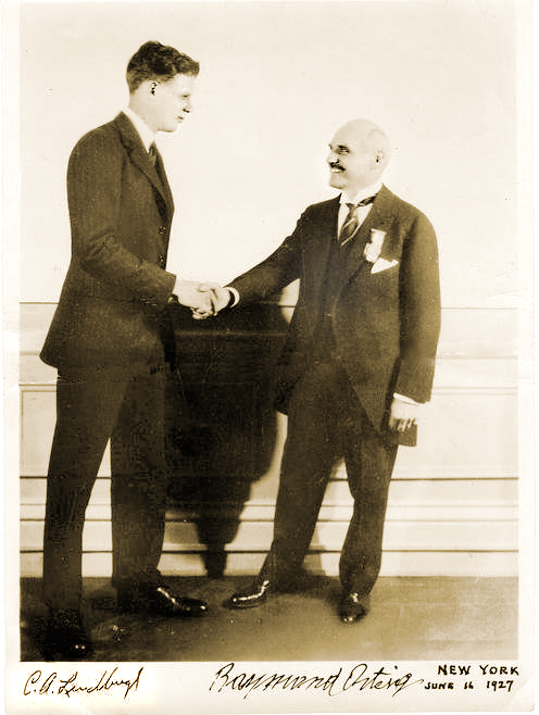
Charles Lindbergh (left) and Raymond Orteig.
Enter Lindbergh
As most of you are aware, then captain, later colonel, Charles Lindbergh took up that dare and won the Orteig-prize on the 21 of May, 1927, when he landed in Paris after a grueling 33½-hour solo flight across the Atlantic. When Lindbergh hit land after being “feet wet” for more than 30 hours and 3500+ miles, he was less than three miles from his intended European entry point, a feat that would be hard to duplicate today without GPS, as even with an unaided inertial system the drift can sometimes be as high as one kilometer per hour.
One part I always find amusing about the Lindbergh transatlantic saga is that after flying with “dead reckoning” as his only means of navigation for 30 hours across the Atlantic, he followed the Seine river all the way to Paris, so he essentially converted from VFR (Visual Flight Rules) to the IFR or “I fly rivers” navigation method for the last part of his journey.
Meteorologists and the sealed barometric equipment Lindbergh carried on board — to prove he never landed enroute or that it was indeed a non-stop flight — would not only verify that fact but also verify that he navigated the Atlantic in what we might call today The Perfect Calm. Indeed, Lucky Lindy picked the perfect 48-hour period for his flight. For those of you who read the book, saw the movie, or were there, will remember that in New York the weather during the night preceding his historic takeoff from the dirt-churned-into-mud runway at Roosevelt Field, Long Island, New York, was less than cooperative. There was a major thunderstorm with lots of lightning and several inches of rain; consequently, many counseled Captain Lindbergh to postpone his flight. But he would have none of it and the rest is history.
The most interesting part of the story, however, is that the entire flight was accomplished with “dead reckoning,” a compass and a watch, the very same tools that Captain Lindbergh used during his tenure as a U.S. Mail pilot. So, in fact, Lucky Lindy actually knew very little about navigating an airplane or avigation, as many called it at the time. Indeed, according to Roger Connor from the National Air and Space Museum and his wonderful article in this month’s Smithsonian Air & Space magazine, Even Lindbergh Got Lost, Captain Lindbergh did not learn to properly navigate with a sextant, chronometer and star charts until more than a year after his famous flight to Paris.
I won’t spoil the story for you, but he learned to navigate as did his famous wife, Ann Morrow Lindbergh, from then Lieutenant Commander Philip V.H. Weems of the U.S. Navy. LCDR Weems set up the nation’s first independent navigation school, and went on to instruct such notables as General Curtis LeMay, the Commander of Strategic Air Command (SAC), who went on to serve as the Chief of Staff of the USAF. Most people are not aware, but General LeMay was dual-qualified as a pilot and a navigator in the USAF. As the Commander in Chief of SAC or CINCSAC, he mandated that all SAC flight crews be able to navigate from Point A to Point B using only passive means that were always available and did not involve transmitting a signal outside the aircraft. In other words, celestial navigation, using a sextant, chronometer, special plotter and star charts, much as was taught by LCDR Weems.
I was one of the lucky SAC flight crew members who learned to navigate with those basic instruments. And checking my logbooks, I find that I made just short of 200 flights (99 round-trips) across the big pond, the Pacific that is, using those basic instruments. I mentioned this to a group of USAF aircrews recently during a speech, and when I asked how many of them could accomplish that feat if required to do so today, I was informed that sextants are no longer carried on USAF aircraft and most do not even have sextant ports. In other words, it is a lost art among flight crews today, and it is a shame, but it is also a topic for another time.
The important fact concerning navigation and time is that time — indeed, precise time — is and always has been critical to accurate navigation, especially aircraft navigation, no matter whether you are flying from New York to Paris, Texas, or New York to Paris, France. And GPS Atomic Reference Systems (Atomic Clocks) on orbit today, which deliver time accurate to millionths of a second, are even more critical since they are the heart of the system. So I would say to my journalist enquirer, GPS and atomic clocks are one and the same. You can’t navigate accurately without precise time.
Weems Legacy
Now, to bring this full circle, I first heard about the proposed Smithsonian Time Exhibit about two years ago from a friend and professional colleague, James Doherty, Captain, USCG retired. Jim, who once served as the Commander of the United States Coast Guard Navigation Center, is a past President of ION (Institute of Navigation), one of the few U.S. members of the Royal Institute of Navigation (RIN) in London, England, and now serves as the Chairman of the newly created Military Division at ION. And for full disclosure purposes, I must say that I have been a proud member of ION for more than 30 years.
Jim, who was serving on a Smithsonian panel as a subject-matter expert on navigation, told me that the Smithsonian had the idea for the time exhibit, but was looking for support, and the first organization to pledge support was indeed ION. The Institute of Navigation certainly does not have the deep pockets of Northrop and Exelis or the other major sponsors, but they are very serious about navigation and they are always looking for ways to promote their vision. This was the perfect opportunity.
And just in case you were wondering, the legacy that Captain, U.S. Navy, V.H. Weems left the world is a method of celestial navigation that persisted as the primary means, especially in the U.S. military and military forces around the world, for more than 60 years and is still the only reliable means of navigation available to us when everything else goes away. For with the Weems Method, as long as you have a sextant and an accurate clock, you can navigate anywhere.
Oh, and one other legacy: Captain V.H. Weems was the founder of the Institute of Navigation, which is the leading society devoted to the advancement of navigation in the world today. And for you trivia fans, the ION predates the RIN by two years.
Sequestration and Cancellations
Normally I would wrap it up here and say grab your sextant and happy navigating, but just as I wrap this up I have been told by informed sources at SMC and AFCEA that the GPS Partnership Council scheduled for May this year has been postponed. Sources at ION tell me that ION/JNC in Orlando has been cancelled for this year due to the restrictions on travel for U.S. government and military officials. In other words, more victims of sequestration and a Congress that can’t make the decisions we elect and pay them to make.
At ION they have always had the mantra, do it right or don’t bother doing it at all, and this year the travel restrictions are just too great. Certainly Jim Doherty and I were in the process of setting up another great Warrior Panel for the classified day, but that will have to wait for another time. However, I am assured by ION Executive Director Lisa Beaty that the ION GNSS meeting from September 16-20 at the Nashville Convention Center is definitely a go, so I look forward to seeing everyone there. Stop by the GPS World booth and say hello. Plus, I hope to see many of you at the 29th Annual National Space Symposium in Colorado Springs from April 8-11, 2013.
Until then, Happy Navigating – blow the dust off your sextant and give it a shot.
Three weeks ago I had a chance to visit the offices of TerraGo Technologies in Atlanta. I first used their technology in the early 2000s, when I was the GIS manager for the Atlanta Regional Commission. For those of you that may not remember GIS and mapping before GeoPDF maps, it was a real challenge to provide interactive maps to users outside your organization. A GIS author had to ship the data layers, attribute tables, symbol sets and layouts as a package to a user who had to have compatible GIS software. One then had to hope that the user pointed to each data layer correctly and had a good sense of cartography to create maps that told the story. If the user chose inappropriate lines, colors or symbology, the resultant map could look terrible at best, misleading at worst.
Esri tried to solve the problem with Map Publisher which maintained the author’s cartography, but if any data layers were corrupted or not pointed to correctly, the map failed. GeoPDF maps solved that problem since all the data layers and even the map layout/cartography were preserved as one single PDF file that could be read and interactively queried by anyone using a simple Adobe Acrobat reader. A user could turn layers on or off, zoom in/out and query attributes. TerraGo also added the TerraGo Toolbar that enhanced the map with measurements, geo-locations and the ability to collaborate with others on the same GeoPDF map.
GeoPDF maps and imagery were quite a leap in map publishing capability and soon became ubiquitous with key federal users and a de facto standard for map publishing within the Department of Defense (DOD) and the U.S. Geological Survey (USGS). Anyone can download many GeoPDF maps free of charge, including U.S. topo maps from the USGS Store.
For federal and DOD users, the U.S. Army Geospatial Center (AGC) has published more than 200,000 maps of locations around the world. Some samples, including 3D GeoPDF maps, can be viewed by the public. In 2009 TerraGo opened “geospatial PDF” technology to all users. As a result you can create “geospatial PDFs” directly from ArcGIS and other geospatial software and display them with the TerraGo Toolbar. TerraGo, however, retained the enhanced functionality of GeoPDFs, including many new additional features and enhancements.
The term “GeoPDF” refers to map and imagery products created by TerraGo software applications. GeoPDF maps and imagery use a geospatial PDF as the container for maps, imagery, and other data used to deliver an enhanced user experience in TerraGo applications. However, GeoPDF products conform to published specifications, including both the OGC best practice for PDF georegistration as well as Adobe’s proposed geospatial extensions to ISO 32000, making them consumable by applications such as Adobe Acrobat, Adobe Reader, Global Mapper, and others. GeoPDF products often include other advanced PDF features such as layers and object data that can add significant GIS functionality to the file, particularly when used with the TerraGo plugin to Adobe Reader or other TerraGo clients. TerraGo even has the capability to create navigable 3D GeoPDF models. Here is an example of a 3D GeoPDF model of the Bin Laden compound. Click to experience the interactive PDF (requires TerraGo Toolbar.)
TerraGo’s geospatial collaboration software and GeoPDF maps and imagery are a powerful solution to produce, access, update and share geospatial information and applications with anyone, anywhere. TerraGo solutions enable enterprises to extend, exchange, collaborate and exploit georeferenced maps, imagery, audio, video, forms and other intelligence in connected or offline environments. I repeat: connected or offline. This is a key GeoPDF capability that cannot be overemphasized.
I learned the hard way during numerous emergency response exercises and events that as the number of responders ramps up, local internet connectivity degrades to the point that it’s difficult to send and receive even simple emails, let alone large data sets such as imagery. GeoPDF technology permits users to collect and assemble large data sets at the early stage of an event, use them and collaborate on the GeoPDF map locally without the need to continually reload the same data from a remote server. Building on this strength, TerraGo developed numerous related products, but the company is evolving in a more fundamental way. According to TerraGo CEO Rick Cobb, the company is moving from a product-centric organization to a workflow solutions company by expanding some of its technology, providing its solutions as APIs and SDKs for integration with high-end systems and using innovative methods to bring its capabilities to remote users even in fringe, disconnected environments.
Part of this evolution included expansion of three technologies:
increased emphasis on use of locally connected mobile devices,
enhancing the capabilities of “Composer 3D” that integrates 3D data such as LiDAR point clouds with 2D data in the GeoPDF environment, and
the acquisition of GeoXray, a “big data” exploitation tool that automates the process of discovering, geospatially visualizing, monitoring and sharing relevant unstructured information from any source.
GeoXray is a web-based software application that allows users to search the Internet and social media sites for content relating to a geographic area and filtering the results by place, time and topic. TerraGo demonstrated interoperability by allowing a user to access GeoXray directly from a GeoPDF map. TerraGo’s Michael Bufkin indicated that the next step in this interoperability will be to cache the GeoXray-discovered content within the GeoPDF map when it is created, thus enabling access to the content directly from the TerraGo Toolbar. Users would then be able to discover GeoXray content even if not connected to the Internet, while using the same tools that they use for map display and collaboration.
It’s hard to fully describe the GeoPDF/GeoXray integration in this short column but picture a sample scenario which was demonstrated for me at GeoINT 2012. A hypothetical analyst needed to determine a probable location of a kidnap victim in a remote country. The analyst first used the general mapping capabilities of the GeoPDF map to identify key geographic locations. Then, using a broad array of “big data” contents such as news, blogs and social media, the analyst was able to narrow his efforts to a few key locations through the discovery and filtering capabilities of GeoXray. Combining and layering the physical geography with mapped locations of relevant GeoXray data, the analyst was able to significantly narrow sites of interest. Further viewing and local collaboration by agents in the field using mobile devices to view and collect additional data could refine the location even more.
This was quite an elegant and robust merging of GIS and “big data” in an easy-to-use application. I look forward to this tool set being a valuable addition for DOD, businesses and any agency that needs fast collaboration in complex environments both domestically and in remote locations.
TerraGo will be an exhibitor at the ESRI Federal Users Conference this week. I’m looking forward to seeing what other new developments exhibitors will be showing at the UC. Please stop me and say hello.
But Google and Facebook Signal Their Intent to Capture Users’ Location
The biggest international mobile-phone show ever, Mobile World Congress 2013, took place early this month in Barcelona, Spain. It came at an interesting time. Attendees learned it no longer makes sense to think about which device, or screen, is of primary importance to users. Google reports findings that 90 percent of users move sequentially between several screens — TV, phone, desktop computer and tablet — to accomplish tasks.
Google, wanting to more fully exploit ad opportunities across all devices, has revamped its AdWords program to be one platform that advertisers will use to control ads on all types of devices. In the past, advertisers could choose to advertise on desktops and no other devices. The new rule requires mobile advertising. Although it is an integrated platform, advertisers can use parameters like the device’s location or type to send specially crafted messaging.
The GPS-based fitness watch market looks like it is on a steep curve upwards, and feasible smartphone GPS watches are available.
Rumor says Facebook is going to start tracking users’ locations at all times, to be able to cull more ad revenue from individuals’ preferences and geo life.
Finally, and most importantly in the long run for all location-enabled users, the Federal Trade Commission took a stand on location privacy.
Google Requires Mobile Advertising. Citing concerns that the shift from desktop to smartphones and tablets is damaging its bottom line, Google is revamping its AdWords advertising platform to integrate ad campaigns across all device screens. In fact, Google indicated that it will require all advertisers to pay for mobile ads even if they only wish to reach consumers on desktops. The revamp will allow customers to use contextual factors like location, time of day and device type to control integrated campaigns.
Google provides an example of how a user’s location and device type could change the advertising message. “For example, a pizza restaurant probably wants to show one ad to someone searching for ‘pizza’ at 1pm on their PC at work (perhaps a link to an online order form or menu), and a different ad to someone searching for ‘pizza’ at 8pm on a smartphone a half-mile from the restaurant (perhaps a click-to-call phone number and restaurant locator),” reads Google’s blog.
Will Apple Grab Your Wrist? Rumors continue that Apple will release a GPS-based fitness watch in 2013. Whether Apple enters the market or not, the GPS fitness market is huge and growing. The GPS fitness watch market is set to reach $1.07 billion in 2013, predicts ABI Research. Cellular-connected GPS fitness watches like the I’m Watch may further speed this market.
“There have already been unfounded rumors around Apple in 2013, so let’s wait and see. If an Apple watch did feature integrated GPS, it would no doubt significantly boost shipment forecasts in 2013,” asserts Dominique Bonte of ABI. Some start-ups in the GPS Watch category have joined the action including Leikr, Pebble, Basis and others.
Facebook Is Watching. Is it possible for the relationship between Facebook and Google to get tenser? According to a Bloomberg article, Facebook is developing a smartphone application that will track the location of its users. The app is said to be scheduled for release by mid-March, and would run on handsets in the background, even when the Facebook app or the phone isn’t open or in use.
The location data would help Facebook capture more advertising revenue as ads can be more targeted with information about a user’s location and habits. The project is said to be headed by an ex-Googler and talent from Glancee and Gowalla, both of whom were purchased by Google.
Location privacy Is Covered. Privacy concerns with Facebook location tracking would undoubtedly be raised. Currently Facebook records the GPS coordinates of users when they post status updates or photos from their phones, or check into a venue. Tracking users 24/7 is another thing. Facebook’s current location sharing policy seems to cover them carte blanche. It allows the use of data “to serve you ads that might be more relevant,” and “to tell you and your friends about people or events nearby, or offer deals to you that you might be interested in.”
Also-Rans. Will Windows and BlackBerry smartphones succeed? Will there be a crack, even a tiny one, in the duopoly of iOS and Android? The biggest worry for Microsoft and BlackBerry is if initial sales of their smartphones are too small to excite developer interest. Without abundant applications, consumers won’t continue to buy these phones. ABI Research is predicting that the demand will be strong enough and is forecasting a BlackBerry installed base of 20 million and Windows smartphone base of 45 million by year end.
Location Standards for Next Generation LBS. The Open Geospatial Consortium (OGC) held a free session and reception at the Mobile World Congress for mobile developers, location data providers, network operators and LBS service users. Attendees learned the latest in open standards development.
Path Social Network Charged on Privacy Infringement. The operator of the Path social networking app has agreed to settle Federal Trade Commission (FTC) charges that it deceived users by collecting personal information from their mobile device address books without their knowledge and consent. The settlement requires Path, Inc. to establish a comprehensive privacy program and to obtain independent privacy assessments every other year for the next 20 years. The company also will pay $800,000 to settle charges that it illegally collected personal information from children without their parents’ consent.
The settlement with Path is part of the FTC’s ongoing effort to make sure companies live up to the privacy promises they make to consumers, and that kids’ personal information isn’t collected or shared online without their parents’ consent.
“Over the years the FTC has been vigilant in responding to a long list of threats to consumer privacy, whether it is mortgage applications thrown into open trash dumpsters, kids information culled by music fan websites, or unencrypted credit card information left vulnerable to hackers,” said FTC Chairman Jon Leibowitz. “This settlement with Path shows that no matter what new technologies emerge, the agency will continue to safeguard the privacy of Americans.”
Path operates a social networking service that allows users to keep journals about “moments” in their life and to share that journal with a network of up to 150 friends. Through the Path app, users can upload, store, and share photos, written “thoughts,” the user’s location, and the names of songs to which the user is listening.
In its complaint, the FTC charged that the user interface in Path’s iOS app was misleading and provided consumers no meaningful choice regarding the collection of their personal information. In version 2.0 of its app for iOS, Path offered an “Add Friends” feature to help users add new connections to their networks. The feature provided users with three options: “Find friends from your contacts;” “Find friends from Facebook;” or “Invite friends to join Path by email or SMS.”
However, Path automatically collected and stored personal information from the user’s mobile device address book even if the user had not selected the “Find friends from your contacts” option. For each contact in the user’s mobile device address book, Path automatically collected and stored any available first and last names, addresses, phone numbers, email addresses, Facebook and Twitter usernames, and dates of birth.
The FTC alleged that Path’s privacy policy deceived consumers by claiming that it automatically collected only certain user information such as IP address, operating system, browser type, address of referring site, and site activity information. In fact, version 2.0 of the Path app for iOS automatically collected and stored personal information from the user’s mobile device address book when the user first launched version 2.0 of the app and each time the user signed back into the account.
The agency also charged that Path, which collects birth date information during user registration, violated the Children’s Online Privacy Protection Act (COPPA) Rule by collecting personal information from approximately 3,000 children under the age of 13 without first getting parents’ consent. Through its apps for both iOS and Android, as well as its website, Path enabled children to create personal journals and upload, store and share photos, written “thoughts,” their precise location, and the names of songs to which the child was listening. Path version 2.0 also collected personal information from a child’s address book, including full names, addresses, phone numbers, email addresses, dates of birth and other information, where available.
The COPPA Rule requires that operators of online sites or services directed to children, or operators that have actual knowledge of child users on their sites or services, notify parents and obtain their consent before they collect, use, or disclose personal information from children under 13. Operators covered by the Rule also have to post a privacy policy that is clear, understandable, and complete.
The FTC charged that Path violated the COPPA Rule by:
not spelling out its collection, use and disclosure policy for children’s personal information;
not providing parents with direct notice of its collection, use and disclosure policy for children’s personal information; and
not obtaining verifiable parental consent before collecting children’s personal information.
In addition to the $800,000 civil penalty, Path is prohibited from making any misrepresentations about the extent to which it maintains the privacy and confidentiality of consumers’ personal information. The proposed settlement also requires Path to delete information collected from children under age 13 and bars future violations of COPPA. Path has already deleted the address book information that it collected during the time period its deceptive practices were in place.
The FTC also introduces “Mobile App Developers: Start with Security,” a new business guide that encourages developers to aim for reasonable data security, evaluate the app ecosystem before development, and includes tips such as making someone responsible for data security and taking stock of the data collected and maintained.
The commission vote to authorize the staff to refer the complaint to the Department of Justice and to approve the proposed consent decree was 5-0. The DOJ filed the complaint on behalf of the Commission in U.S. District Court for the Northern District of California on January 31, 2013. The proposed consent decree will be filed with the same U.S. District Court today and is subject to court approval.
Janice Partyka is contributing editor for wireless at GPS World. Subscribe free to her monthly e-newsletter, Wireless Pulse, at www.gpsworldcom/subscribe.