Tarun Bhattacharrya, Hassan El-Sallabi, Jian Zhu, Jeff Wu, and Per Enge.
Radio-Frequency Pattern Matching
By Tarun Bhattacharrya, Hassan El-Sallabi, Jian Zhu, Jeff Wu, and Per Enge
Radio-frequency pattern matching (RFPM) is the engine that enables the use of mobile-phone signals to locate wireless devices in any environment, including dense downtown areas and indoors. This exciting technology leverages the power of the database to improve location accuracy to within 50 meters in even the toughest signal environments. Significant advances in RFPM technology have been made over the last 10 years. The system described here is deployed in more than 24 wireless networks to provide the location of E-911 callers and help save lives. For simplicity, we focus on the RFPM using signal strengths even though the technology also works with arrival times, signal-to-noise ratios, differential signal strengths and any signal parameter that varies in a predictable fashion over the coverage area.
Like GPS, RFPM is based on correlation. However, it does not correlate a received spread-spectrum code with a replica code stored in the receiver. Rather, it correlates the signal strength of cell-phone signals measured by the roving phone to a database that contains a map of those signal strengths for the covered area. Consider Figure 1. It shows this key correlation operation. As shown, the database contains a k-vector for each location within the covered area, where the k elements give the estimated strength for the k mobile phone signals that can be received at the given grid point. These k-vectors are typically stored over a 10- or 30-meter grid. This grid of predicted signal strengths is built in advance and is updated only when the topography of the wireless network changes. Thankfully, base stations do not generally move!
Figure 1. Radio-frequency pattern matching of n-vector from mobile user to k-vectors within database.
The mobile phone provides the network measurement report (NMR) in real time. This report does not require any network hardware or on-phone software beyond that required by the 2G, 3G and LTE standards for all mobile phones. Thus, the Polaris Wireless solution is capable of locating any mobile phone over any air interface. The NMR is also shown in Figure 1. It contains an n-vector of received signal strengths, where k ≥ n. A multiplicity of n-vectors are backhauled to the server that contains the database. They are correlated with the k-vectors, and the estimated location of the mobile phone is the location associated with the maximum correlation.
For Example, San Francisco
Figures 2, 3, and 4 explode the RFPM database for the financial district of San Francisco. Figure 2 is the top view, and the Bay Bridge is shown heading northwest across the Bay. The numbered black dots are some of the base stations in action for this area. Figure 3 digs down one level. It shows the individual k-vectors contained within the database. As shown, this database is based on a 30-meter grid. Figure 4 is a super-zoom that explodes the individual k-vectors. As shown, each of these vectors contains an element for each base station that can be received at the given location. In Figure 4, each element is color coded to correspond to the strength for the signal from the given base station.
Figure 2. Coverage area of an RFPM database within San Francisco.Figure 3. Zoomed view of San Francisco database showing a multiplicity of k-tuples.Figure 4. Radio-frequency pattern matching of n-vector from mobile user to k-vectors within database.
Building the Database
RFPM accuracy depends strongly on the quality of the database, which needs to be built with great care. In fact, signal propagation depends on the network topology including:
◾ antenna location, heights, patterns, effective radiated power, tilt, and azimuth
◾ cell type, such as micro-cell, macro-cell, indoor or distributed antenna systems.
Signal propagation also depends on information available from geographical information systems such as:
◾ tree canopy
◾ height of buildings and terrain
◾ topography (water, open area, suburban, urban)
◾ roads.
With this data, the signal strength radiating from a base station can be estimated. This is not a simple business. For example, the calculation must identify the points where terrain or buildings interrupts the ray from the transmitter to the receiver. It must also identify the points where these obstacles break the Fresnel zone that surrounds the ray.
Finally, these open-loop predictions are tuned based on a sparse set of measurements. Once tuned, the database is time invariant or nearly so. If minor changes are made to the network topography, the open loop predictions alone are sufficient to accommodate the changes. If network changes are significant, such as the building of many new base stations, then the open-loop predictions must be updated, and a new set of measurements used to tune the predictions.
Figure 5 shows a typical map of signal strengths surrounding one mobile phone in a completely open area. Absent terrain and buildings, the signal strengths vary rather smoothly. Figure 6 is for one of the transmitters in the San Francisco financial district, which is a much more complicated urban environment due to the dense concentration of high-rise buildings and uneven terrain. In this case, the signal-strength signature has a gratifying abundance of detail. This detail enables RFPM to work very well in the complicated signal environments that we find in downtown areas and also indoors. In short, RFPM benefits from the buildings and terrain that hinder satellite measurements.
Figure 5. Predicted signal strength for a transmitter surrounded by open ground.Figure 6. Predicted signal strength for one transmitter in the San Francisco financial district.
Performance and Summary
RFPM works well. It provides high accuracy in a in a wide variety of environments. Polaris Wireless routinely tests the accuracy of its solution in urban settings. Table 1 shows the results of such evaluations, based on measurement sets that are not used to tune the database.
Table 1. Evaluations based on routine accuracy tests of RFPM in urban settings.
These days, robust navigation for downtown and indoors is based on an expanding suite of location technologies. These include: assisted GPS, new satellite constellations (Galileo, GLONASS, Compass, and so on), inertial measurements, Wi-Fi ranging, and signals from low-Earth orbit. RFPM, and its unique reliance on database-derived location, should remain an important part of this mix.
Tarun Bhattacharrya is vice president of research at Polaris Wireless. He earned his Ph.D. in electrical engineering from the Indian Institute of Science.
Hassan El-Sallabi received his D.Sc. in electrical and communications engineering from Helsinki University of Technology, Finland. At Polaris he works on RF propagation modeling.
Jian (JET) Zhu received his Ph.D. in electrical engineering from Georgia Institute of Technology; he is a research engineer at Polaris.
Jeff Wu focuses on algorithm development for propagation modeling at Polaris, and is a Ph.D. candidate in electrical engineering at Stanford.
Per Enge is the Kleiner Perkins professor of engineering at Stanford University, where he directs the Stanford Center for Position, Navigation, and Time. He is also a technical advisor to Polaris Wireless.
This month we present a guest column by James D. Litton, who attended the 2012 GPS Partnership Council, jointly sponsored by the Armed Forces Communication and Electronics Association and the U.S. Air Force GPS Directorate. The key topic of this year’s council quickly emerged as the tension between commercial off-the-shelf GPS receivers and official military issue; the two are used side-by-side in active military theaters.
By James D. Litton
This year’s GPS Partnership Council provided among other highlights a discussion of the tensions between commercial off-the-shelf (COTS) receiver systems used in tactical combat operations versus official military GPS user equipment (MGUE), and an enthralling warfighters’ panel that revealed much of those COTS/MGUE dilemmas. The event, held May 1–2 in El Segundo, California, drew an enthusiastic and involved audience, including many GPS veterans. I was struck by the graying of the clan as well as the practiced and confident presentations of current civilian and military program staffs.
Keynote speaker Brig Gen Martin Whelan, Director of Requirements, Headquarters Air Force Space Command, emphasized that ideas for improvement of the system would be hard sells under current budget realities, but good ideas for lower cost would be welcome. Referring to the three segments — space, ground, and user — he recommended that the segments should talk with each other and challenge requirements. In effect, he implied that the separate segments could reduce overall costs, rationalize requirements, and cooperate better in optimizing the resilience and flexibility of the system, including — this is my interpretation — taking advantage of the “competitive” GNSSs to effect user satisfaction.
According to Whelan, resiliency of the space segment is a top priority; smaller satellites, hosted payloads, and net-centric designs were highlighted. He commented that multiple GNSSs should be employed in such a way that the user does not know the difference.
Regarding the upcoming budget, he told us that Department of Defense will be cut by 22 percent, the Air Force will drop 9 percent — but the AF space budget only 1.5 percent. A notable exception to the generally favorable overview was his comment that the MGUE segment, from a distance, looked uncoordinated. Much more along this line came up later during both days of the Council.
Widespread COTS. There was an air of defensiveness about the user segment, and many comments on both the success and the risks associated with the widespread use of COTS user equipment. We heard further commentary on the very infrequent use of SAASM keys, due to the difficulty of procedures to obtain and employ them, and due to the perception of very low risk of jamming and spoofing threats in current combat deployments.
A session on “The Future Military Receiver” enlisted two panels of government experts and contractors from Deere-NavCom, Garmin, IEC, Johns Hopkins Applied Physics Labs, Raytheon, and Rockwell-Collins. Although the unclassified nature of the presentations limited the level of detail, it clearly emerged that many tactical, in-combat deployments of COTS GPS receiver systems had occurred and continue to occur.
A video compared the jamming resistance of a Garmin receiver with that of approved GPS User equipment receivers. It showed a screen of the Garmin receiver losing satellites at greater distances from the jammer and losing lock at closer distances. Directorate employees and officers made several references to the risks from dependence upon COTS receivers, and related with considerable candor the difficulties with large, expensive, power-hungry MGUE, both mobile and platform-mounted, models of which were held up during the presentations — often to laughter from some in the audience.
More on this followed in Day Two’s dramatic warfighters’ panel, which many people felt was by itself worth the price of admission. These experienced users of GPS under fire — from Coast Guard search and rescue to Air Force forward controllers calling in air strikes within range of small-arms fire — related direct personal experience in a broad array of critical applications. They clearly knew how to use COTS equipment to good advantage and described the operational protocols developed from hard and sometimes painful experience.
Manipulation of multiple screens in a heavy device, which requires initialization or synchronization before dismounting, was often simply not an option. Translation of such experience into qualified requirements is a major challenge for the Air Force and Army. Overdependence on the anecdotal but very valid combat experiences would weaken a design against an enemy with even rudimentary jamming and spoofing capability.
An astute questioner asked “Have you seen any evidence that the enemy (in Afghanistan) has changed tactics because of our technology?”
The answer came “Not yet,” with a comment that the enemy’s early warning systems are very sophisticated and the target of a mission to capture a high-value individual (HVI) frequently knows that such a mission is underway; his support network spirits him away and attacks the mission with the advantage of surprise denied to our forces, abetted by the advantage of favorable terrain and numbers accruing to the enemy.
The Puck. The Army-led MGUE program status was described as being at technology readiness level (TRL) 6.0; the request for proposals was released on April 16. The key to the success across platforms of this “system of systems” was said to be the Common GPS Module (CGM), also referred to as the Puck. This module is M, P, and C/A code-capable and SAASM-capable but has flexible interfaces and “emulates commercial.” The module itself is a system-on-chip (SoC) that can be integrated across many platforms. Depending upon the level of integration employed, it can be as small as chips found in smartphones or somewhat larger.
The program schedule was defended as having only been funded two years ago and having very complex security and platform interfaces. This program presentation drew a large number of questions and commentary from the audience, much of it politely skeptical and showing impatience with the bureaucratic aspects of the program. Well-informed former military field-grade officers in the audience questioned its real availability. The answer that it would be available in quantity sometime in 2017 did not please the questioners.
In short, procurement regulations appeared to be the highest barrier to a rapid, flexible program for a net-centric, open-architecture system development.
Currently, the circuit boards for the MGUE are classified secret, but it is hoped to have these at a confidential or unclassified level for deployment by handling the encryption exclusively in software. The leader of this presentation indicated that software receivers were the ideal but were not available, so reduction in size, power consumption, and complexity in hardware was the goal.
Trumping Military. One almost nostalgic comment hearkened back to the time when military systems were regarded as the height of technological excellence, whereas it is now generally perceived that commercial systems trump the military in sophistication. Garmin claimed to have developed SAASM receivers in the lab but found little interest from business leaders at that time.
The CEO of Mayflower Communications, which makes and sells miniaturized SAASM receivers, pointed out that anybody could make a SAASM receiver employing a Sandia crypto-chip approved by the U.S. National Security Agency (NSA) but pointed out, as did several others, that the availability of certifications and authorizations was very limited, and that volume drove cost. Implicitly, NSA’s requirements and protocols got blamed for the limited distribution and use of SAASM receivers.
Day Two
The second day of the GPS Partnership Council comprised The Nation and The Warfighter. In the latter group came an outline of the Army’s COTS vision and — the hit of the entire conference — the Warfighter panel with a keynote introduction by a USAF colonel warrior now at the GPS Directorate.
The Nation. Tony Russo, director of the National Coordination Office for Space-Based Positioning, Navigation, and Timing, disabused those who thought that the apparent demise of the LightSquared threat had eliminated that subject from his agendas; he still deals with it often. He provided entertaining and informative examples of non-obvious and valuable applications of GPS, from assessing rugby players’ game performance through detection of clandestine underground nuclear tests to a social application of matching available part-time and temporary workers with jobs when labor demand surges and a roster shows where the closest qualified candidates are.
John Merrill of the Department of Homeland Security (DHS) identified 18 critical infrastructures that depend upon GPS integrity and showed the cascading effect of taking out sites like SCADA (Supervisory Control and Data Acquisition) systems. He related a threat-illustrative story of a DHS agent who required constant contact via his agency smart phone but who could not get reception while attending mass in church. The pastor later and very proudly showed him the mobile phone jammer in the sacristy; he had given up on asking parishioners to turn off their cell phones off during services.
James Miller of the National Aeronautics and Space administration noted that only 5 percent of space missions lie outside the GPS coverage envelope (3,000 kilometers to geostationary altitude of 35,800 kilometers is the space service volume). Reducing the burden on spacecraft tracking networks is a highly profitable application for GPS.
Warfighters Panel. These real-life experiences from combat and other vital operations could easily justify an entire article of their own. The following examples will illustrate the life-saving force multiplication of GPS, particularly the ubiquitous civil GPS technology in the current combat environment.
• An Air Force Special Operations Major described a mission to snatch an HVI, giving great detail on battlefield terrain, combat conditions, and how he worked between a COTS GPS receiver and a COTS handheld computer with Google Earth-like facilities to bring JDAMs (GPS-equipped smart munitions) onto an ambush mounted by defenders of the HVI, who were alerted to the raid by their extensive and sophisticated early-warning network consisting of sympathizers with cell phones. His description of the heroics of individual forward controllers, their injuries and fatalities, and the symbiosis of man and machine in a relatively benign electromagnetic interference but relatively malign electromagnetic propagation environment, and overtly and covertly hostile indigenous population, was dramatic and compelling.
Clearly, unsophisticated and easily-available high-power jammers rapidly alter such situations to reduce our technological advantages. Also clear was the need to design user equipment, not just to reject interference but to minimize time and the inevitable ambiguities in actual combat situations.
• A Coast Guard lieutenant described the search-and-rescue missions he flies out of local airports to Pacific Ocean sites. Again, COTS equipment, aided by the near-ubiquity of commercial GPS equipment, along with VHF marine radio on boats and ships, enhances these mission results over those flown with standard USCG-issued navigation equipment.
• An Air Force tanker pilot major now attached to the GPS Directorate described three personal experiences. He once had to ask his boom operator to retrieve the Garmin receiver issued in the survival kit in order to navigate the tanker for rendezvous with tactical aircraft needing fuel when the tanker’s standard equipment failed.
When tasked to fly into an airport in Afghanistan with unreliable navaids, under suddenly occurring zero-zero conditions, the onboard GPS enabled him to land safely.
In a third instance in Iraq, he observed a downed airman being approached by gunmen. The gunmen with AK-47s were being targeted by drone operators. The major was able to discern that these gunmen were friendly forces moving to rescue the downed airman and avert a friendly-fire disaster. The downed airman’s ability to send his exact coordinates were key to the ability of the observer to get close enough to direct rescue efforts and to avoid a fatal error.
• A Navy surface warfare lieutenant commander and a CWO Riverine or small boat skipper cited instances in which GPS was essential to missions and ways in which user equipment design could improve their operations — for example, by making it float.
All the veterans repeated, during or after their accounts of ways in which GPS saved lives or enabled missions, “thank you for what you do,” addressed to the audience, the presenters, and their leaders. Going into denied territory places a high premium on user friendliness, battery life, robustness, size, and weight. In the future, inevitably, jam and spoof resistance will be an object of gratitude, as well.
Final Review. We all know these things, intuitively and by doctrine, but hearing reports from people in harm’s way or retrieving comrades from harm’s way was a great addition to the usual program and technology descriptions by the development teams.
I was particularly impressed with the very articulate, sophisticated, and focused presentations of these combat veterans. It is highly incumbent on the industry and the government GNSS leaders to translate these experiences into design requirements quickly, so that future systems are less dependent on individual ingenuity and on commercial gap-fillers.
Much of this progress depends on truly incorporating the applications focus of commercial product development and on use of other GNSS systems for robustness, flexibility, and affordability — often quoted as mission goals by the leaders of this enterprise.
Few of us fully appreciate the significance of the Qur’an burning in Afghanistan by our troops several months ago. The best analogy I can think of is burning of an American flag. As any Boy Scout can tell you, the proper way to dispose of a worn American flag is to burn it in a dignified manner, however burning that same flag at a protest launches quite a different reaction. The same occurred when our troops burned Qur’ansthat had been desecrated by prisoners. Writing in a Qur’an is considered a desecration and the desecrated Qur’an is supposed to be burned. Our soldiers didn’t understand that there is a ritual associated with the burning, similar to American flag disposal, and thus the uproar heavily fueled by activists throughout the Mideast.
Between emails and phone calls, I personally haven’t had the time northe interest in Tweets, Facebook or texting, so I didn’t appreciate the impact that social media has in many Mideast countries. Most third world countries haven’t gone through the technology progression of newspapers, phone lines, broadcast and cablewe have but instead jumped directly to cell phone and wireless technology. In many countries wireless social media is a dominant method of communication although in many rural areas the high illiteracy rate and limited number of wireless users place those users in strong positions to limit or distort the information they receive.
Soon after the social media fueled Qur’an burning incident, two small US businesses were able to have a surprising impact calming tensions by using human geography and personal action. The effort was possible thanks to the work of retired Air National Guard Brigadier General Edwin (Skip) Vincent. Throughout his military career, including 23 combat missions in F4’s, KC 130’s and 135’s, General Vincent was constantly at the “tip of the spear” involved in combat or support missions. He also built strong personal relationships with military leaders throughout the Pacific Rim including retired Pakistan Army General Azam Effendi.
General Effendi and General Vincent had been working together for a while on economic development and disaster preparedness issues through General Vincent’s business, Soft Power Solutions (www.soft-power-solutions.com). Their efforts included discussions of GIS support for disaster response and recovery efforts along with efforts to stage emergency response supplies and equipment in the event of natural disasters.
Soon after the Qur’an burning incident, General Vincent and General Effendi decided to see what they could do as a grass roots reconciliation effort. They teamed up with Catherine Dunlap, President of a Virginia based firm, Halcyon Group International (www.halcyongroupinternational.com) to formulate a simple but effective plan.Halcyon Group International provides expertise in counterinsurgency, stability, and influence operations in regions of conflict or transition for the United States Government and partner nations to achieve strategic, operational, and tactical level objectives. They used their knowledge of cultural geography and local contacts to identify and analyze the situation.
Soft Power Solutions used geospatial tools such as GeoCOP and TACTweet (www.GeoCOP.com) to analyze thousands of social media messages. The software scanned public access social media that addressed specific topics and identified the source locations. These tools permitted them to get a clear picture of the spheres of influence and their specific geographic locations. Understanding the “human terrain” they were able to formulate a relatively low key response to the massive protests.
Although the burning occurred in Afghanistan and the protests originated in Bahrain, geospatial analysis determined that northern regions in Pakistan and adjoining Afghan regions were the key areas of influence and starting point to hopefully quell the riots. Together, the Generals formulated a relatively simple reconciliation plan to provide 5,000 Qur’ans with letters of condolence to be delivered to local tribal leaders and clerics. Using the many friends and contacts that they had previously made the effort turned into a public/private partnership that involved over 220 leaders with 22 presentation ceremonies in 16 regions. The regions included four in Pakistan and 12 in Afghanistan. Using her extensive knowledge of Pashtun culture and local customs, Catherine Dunlap helped draft a letter of condolence. Letters, regarding the misunderstanding of the proper way to burn Qur’ans, were worded in a way to open doors and quell resentment.
Shown here are hundreds of the gift Qur’ans. On 29 February visits to distribute the 5,000 Qur’ans and letters of explanations were started. Although this was a non-governmental effort, word of the action spread and the participants received safe passage through the Khyber Pass escorted by both Pakistani and Afghan troops. Despite threats of retaliation from the Taliban, all the meetings were peaceful and warmly received by local leaders.
By March the 2nd there was growing participation of local leaders and clerics including radio and TV coverage. One of the clerics was a very well-known and respected imam who was a direct descendent of Muhammad. He responded enthusiastically to the gesture by issuing a Fatwa calling for peace and forgiveness. This was a significant game changing event since a Fatwa issued by the imam carried significant weight in the world Muslim community.
By March 7, monitoring of social media indicated a positive reaction from local populations and as of the publishing day of this article, no further protests or killings related to the Qur’an burning had been reported.This effort ultimately spawned a massive grand assembly or “Loya Jirga” of tribal leaders. This was the first Loya Jirga in 167 years that originated at the grass roots leveland not government initiated. Discussions ranged from the war, to economic development and even included women in the discussions. One can hope that this leads to bigger and better things.
As a GISP, I’ve neglected one aspect of my GIS continuing education, human terrain and human geography. I’ve seen increased use of “crowd sourcing” from social media for marketing, disaster response and even politics. Programs such as GeoCOP made the effort by the two Generals possible. The impact of this public private effort with a total cost of only $25,000 has focused my mind sharply and I’m going to work to fill this education gap.
When one considers the size of the vehement protests and deaths of over 23 NATO forces and demonstrators, it’s quite amazing and should be a source of pride that two small companies and two retired Generals could accomplish so much using their knowledge of the culture, geospatial tools, social media analysis and the simple distribution of 5,000 Qur’ans. We’ve all heard the term “asymmetric warfare” but this was a clear example of an “asymmetric peace effort.”We’ll never know for sure, but I can only imagine how many of our soldiers would have come home in flag draped coffins had it not been for this rapid grass roots peace effort.
As loyal readers are aware, I have long been an advocate of signal diversity as a solution to many of the ills that plague the GPS user, especially outdated user equipment. Signal diversity potentially provides users with more signals and signal origins. More signals improve availability, the number-one user criteria by a huge margin, and serve as a defense against jamming and spoofing. Signal diversity also provides security and integrity, resulting in accurate and reliable GPS-derived data.
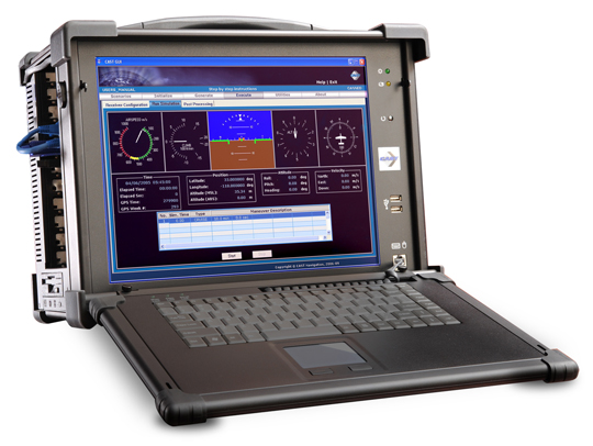
For users to take full advantage of signal diversity, they must have the best software-defined user equipment available. And the best equipment, if it were available today, would be the PHGPST or Perfect Handheld GPS Transceiver, which has so often been a popular topic of discussion over the last several years. I cannot count the thousands of letters and emails from warfighters, first responders, and civil users who immediately see the value of software-defined receivers and want to know where to purchase the PHGPST. For now, some early GPS software-defined user equipment does exist, but to reach the goal of the PHGPST, receiver manufacturers must first be able to accurately and reliably simulate/generate all the diverse PNT (position, navigation and timing) signals available, which include some signals not ordinarily categorized as PNT signals today. Certainly not an easy task; however, there is hope. Recently, I heard about a small GNSS/INS simulation company that may be paving the way to the PHGPST — CAST Navigation in Tewksbury, Massachusetts.
CAST Navigation
CAST Navigation, which qualifies under current federal acquisition guidelines as a small company, bills itself as, and my military contacts confirm that they are indeed, a leading provider of GPS signal simulators, as well as a company that supports navigation system research, development, integration and testing at commercial and military laboratories worldwide. CAST develops cutting-edge GNSS/INS simulation systems with an expert staff that provides their customers with the latest technology and knowledgeable, experience-driven support.
Tough Industry
Those of you who are real GPS techies should not have to think very hard to call up the names of at least three GPS–PNT signal simulation companies that have gone belly-up in the past five to ten years, and some of those memories are just plain painful for the U.S. military and industry alike. This can really be a tough business.
According to Susan Gove, vice president of CAST Navigation, “…the signal simulation field is certainly not an easy business and it is extremely competitive, but we have been around for a long time and are doing well,” which is exactly why a company like CAST Navigation — which has survived and grown for the last 25+ years with an outstanding track record — is of such interest when it comes to PNT signal diversity and the PHGPST.
Add the fact that recent Information Assurance (IA) and cyber security requirements have just made the GNSS business tougher for all concerned and a reliable, professional, flexible GNSS/INS signal simulation company becomes critically important to the industry as a whole. According to John Clark, VP for Engineering at CAST Navigation, “…our scenario-based software simulations, which include jamming, interference, multipath signals and spoofing allow for simultaneous and multiple scenarios — indeed, almost any battlefield signal perturbation the user needs to simulate is doable with our hardware and software. In fact, we routinely help our customers tailor scenarios for specific needs, and our customer feedback mechanism tells us our customers are extremely happy and productive with CAST Navigation’s scenario-driven software capabilities.”
A major requirement for signal diverse solutions to GNSS issues — to include jamming, unintentional interference and high masking angles — is the right antenna. Conventional wisdom says the right antenna is a Controlled Radiation Pattern Antenna or CRPA. Ideally, the right CRPA will eventually be capable of receiving all space-based PNT and SBAS signals (GPS, GLONASS, Galileo, Beidou, WAAS, EGNOS etc.) as well as ground-based cellular and LF (low frequency) and/or eLORAN signals. The CAST-5000 Wavefront simulator allows companies and the military to perform a full end-to-end test of a platform’s CRPA, the antenna electronics, and the GPS receiver before that receiver is ever deployed to the field. So it is a must-have capability for the truly signal diverse GPS receiver manufacturer. But to be honest, GPS signals are still key; they are still the gold standard for PNT. I am not aware of any GLONASS-only receivers on the market today, nor am I aware of any Galileo-only receivers being planned. GPS is the key component for available, reliable, and accurate PNT data.
Recently at the Munich Satellite Summit, all the European receiver manufacturers were touting GPS receivers with the Galileo/GLONASS option. Even if the marketing brochures list Galileo or GLONASS first in the name, a little probing makes it obvious that the primary baseline PNT system is GPS with augmentations. So although signal diversity is the goal and more and more systems are, to some extent, signal diverse or signal-diverse capable today, the reality is that GPS is still the Gold Standard. If we are ever to truly enjoy signal diversity and all the associated benefits, PNT signal generators and simulators will be a key developmental tool. To that end and with affordability in mind, CAST Navigation has the capability or is in the process of developing simulations for many of the diverse signals mentioned to include SAASM signals for the U.S. military and our allies.
Simulations and Predictions
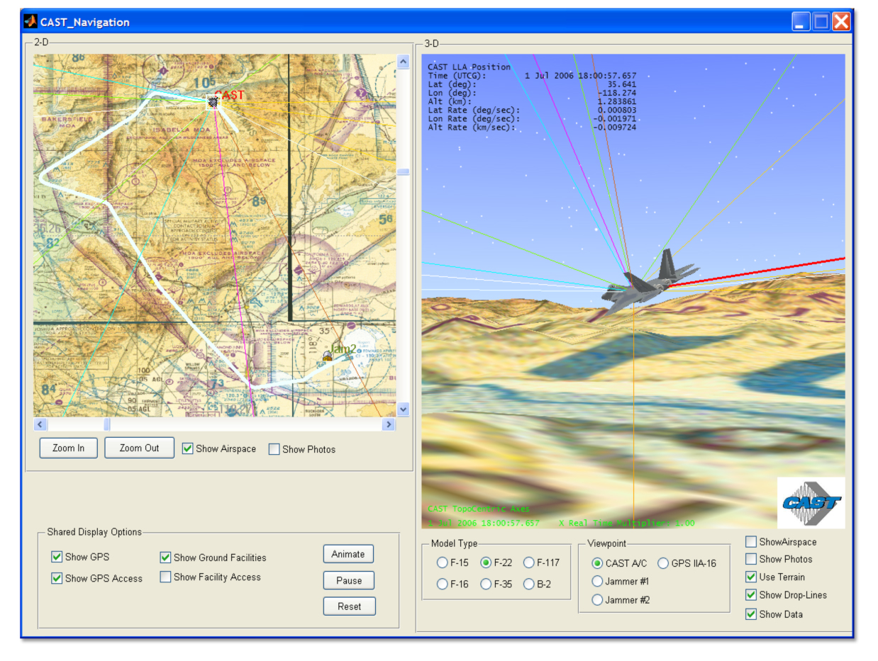
For the past several years the DoD and several government agencies have made good use of a very functional PDOP (positional dilution of precision) prediction algorithm and tool named GIANT. General Dynamics originally developed the GIANT program under contract to the U.S. government. Currently, GIANT is being enhanced primarily by LINDQUIST, with the help of select government agencies; with the recent integration of Google Maps, GIANT is proving to be a very useful tool for the warfighter and first responder. Amazingly CAST Navigation has a very similar product that is available for all users to include the U.S. military. The CAST product is called TOP or Terrain Obscuration Program. Like GIANT it provides a real-time determination of satellite visibility based upon the terrain (presented in a 3-D visualization) surrounding the actual position or predicted position of specific GPS receivers, fixed or mobile.
(Click to enlarge.)
While this concept sounds a bit academic at first, when you see it in action and talk to warfighters and planners who have benefited from GIANT first hand, it is clearly a mission-success parameter as well as a life-saving capability. For years GIANT was purely a flat Earth planning tool, and while it was useful, the addition of real-time processing, Google Maps, and DTED data have made both GIANT and TOP incredibly useful programs. Both programs help ensure GPS user equipment, applications, and weapon systems are more accurate, since signal availability is now predictable. The first time I saw the new GIANT tool in action, it literally took my breath away, and now that capability is available for everyone with the TOP product from CAST Navigation. Knowing first-hand what both GIANT and TOP are capable of for warfighters and first responders, I cannot now imagine a government, commercial, or civil planner, who must utilize or install GPS equipment or systems that depend on GPS capabilities, that would not benefit from these groundbreaking programs. In a natural or urban canyon situation, with high masking angles, installing GPS receivers or antennas with the greatest visibility would be pure guesswork without a program like TOP that guides planners and installation engineers with real-time data extrapolating optimal PNT reception locations, both fixed and mobile, over time.
SGX
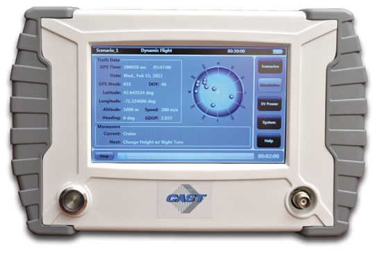
Combine the capability of GIANT or TOP with a portable or handheld GPS signal generator/simulator, such as the new handheld CAST SGX, and users are able to accurately characterize and predict the effects of area terrain and masking angles on any GPS receiver prior to actually venturing into the field. Users are able to determine which receivers will function optimally and produce the most reliable results in any physically constrained or sky-challenged environment. For both government and civil users, the fidelity of TOP and GIANT are a direct function of and only constrained by the Digital Terrain Element Data (DTED) access authorized for specific users.
The CAST SGX (signal simulator/generator) is a GPS signal device housed in a portable lightweight handheld enclosure. In other words, it is a portable handheld GPS signal device at home in the laboratory, running on house current, or in the field running on long-life batteries. Regardless of the power source, the CAST SGX is capable of generating GPS L1 signals (with P-Code options) of up to 16 GPS satellites, which are more than most users would normally have in view at any one time.
The CAST SGX is an important new development in GPS signal simulation and generation. Historically GPS signal simulators/generators have been huge, heavy and complicated pieces of laboratory equipment requiring a Ph.D. to run properly, and users were tied down to evaluating GPS receivers only where the unwieldy GPS signal simulator/generator was located. Now with the portable CAST SGX, the signal generator can go where the receivers are located and real-world data can be collected in real time. The scenarios the SBAS (satellite based augmentation system) capable SGX have made available are extraordinary, and I have purposefully not speculated on the military possibilities as those speculations become classified in a hurry. But just allow your imagination to wander a bit and you will see what I mean.
SGX Software
The optional CAST-XGen Plus software, which I have not had a chance to personally test but hope to in the near future, has the capability to integrate with Google Maps and reportedly gives the user the ability to generate advanced customized scenarios for use with the SGX device. The software allows for complete control over atmospheric effects, the GPS almanac, ephemeris and all satellite error sources to include masking angles and multipath. So you don’t actually have to take the SGX device out into the field, but the great part is now you can. Ruminate on that for awhile and the possibilities appear endless.
According to Susan Gove, the handheld SGX is proving to be a huge success, and the SGX along with CAST Navigation software products will be available at the ION 2012 Joint Navigation Conference (ION JNC) June 12-15, at the Crowne Plaza Hotel in Colorado Springs, Colorado. Be sure to stop by and take a look at this amazing new product.
Bottom Line
I am impressed by what I have learned about CAST Navigation. They are a small, agile, innovative GNSS/INS simulation company that has brought much needed portability and availability of GPS signals and simulation to operators, planners, and system designers worldwide. CAST Navigation hopefully has a bright future and may well play a key role in the future of the availability and integrity of GPS signals for users globally. They may also help blaze the path to the PHGPST. Check them out at ION JNC.
Because LBS Insider’s deadline is this week, CTIA coverage from New Orleans is not included in this month’s column. Janice Partyka, editor of GPS World’s Wireless Pulse, is covering CTIA in the Crescent City for the latest location-based services, M2M, and connected vehicle news. So instead of talking about CTIA (and why there aren’t many pure LBS players or sessions there anymore), this column examines the hype surrounding indoor positioning — is it LBS’ savior, or just another technology that may, or may not, pan out?
The location industry will know very soon whether indoor positioning is just another overhyped technology niche — or the needed capability that will drive the largest advertisers and retailers to finally embrace location-based services. Some industry analysts say indoor location may take off in as few as 12 months — particularly if smartphones include the feature in new product offerings.
At several location industry conferences, the obligatory indoor positioning panel is cropping up, leading some to believe that while intentions are good, perhaps the technology hasn’t developed fast enough. The jury is still out on indoor positioning. “It is badly needed, but also needs to be down to the meter-level,” said Ralph Eschenbach of Sand Hill Angels, a venture capital firm, at the recent GPS-Wireless 2012 conference. “The technology is not here yet.”
Another contrarian said that industry segments like automakers need not just show users how to navigate to destination, but give folks information when they near the area. “It would be nice if a BMW told me where’s the cheapest gas,” said Gary Gale, Nokia director of places, location and commerce.
Some analysts, like those at IMS Research, believe that an indoor positioning technology will be from multiple sources — though Wi-Fi has been the primary tech solution. IMS cites reports that say Bluetooth in Nokia’s HAIP can meet the one-meter threshold of accuracy for indoor markets.
IMS said the major indoor positioning players, so far, are Google, Qualcomm, Broadcomm, CSR, Qubulus, Nokia, NextNav, and Path Intelligence.
While intangible benefits such as measuring consumer behavior and shopping experience will be important for retailers and advertisers who are hoping to fund indoor positioning systems, the goal is to drive customers to the stores. This will also be tied into the “what do I do when I get there” answer to the navigation question.
Still, the benefits will be transparent to advertisers once consumers are able to save time, and perhaps money, with indoor positioning capability on their smartphones, said Ankit Agarwal, CEO of indoor positioning company, Micello. “There is definitely a business model for indoor positioning. It enables product search and walking paths throughout a store,” he said. “Stores will be able to track multiple routes folks are interested in taking [through a store].”
Once again, Google seems to be the major player in indoor positioning. LBS Insiderreported late last year that Google went indoors with the launch of Google Maps 6.0. The company has attracted some of the big-box retail stores such as IKEA, Macy’s, Home Depot, and Bloomingdales to have their stores mapped. However, a lot of the bigger malls, and Target and Wal-Mart, have not been mapped. The Google product tells customers what floor they are on in a building, but so far is only available for Android.
Google’s indoor mapping partners include 18 U.S. airports, which will open up more partners and LBS relationships in the future.
In other news, but related to indoor positioning and other LBS markets, Greg Tarr, partner at Rogers Venture Partners, said at GPS-Wireless: “There is no privacy…get over it.”
TomTom Launches Global Geocoding Web Service
As GPS World reported, TomTom launched a new volume batch geocoding web service late last month at the Geospatial World Forum in Amsterdam. Geocoding, the process of converting addresses into geographic coordinates to allow location analysis for businesses, is taking on a new twist with the new product.
“This not your father’s geocoding. The turn-around time to download the product will be attractive to companies,” said Dan Adams, TomTom vice president, location and live services. “When I was with GDT and we were acquired by Tele Atlas, it gave us more exposure to global geocoding. Since the TomTom acquisition, there has been a recasting of those products, with the same sort of dynamics, but bringing them to the Cloud.”
What Investors Look for in a Location Company
In a venture capital panel at GPS-Wireless, industry experts basically say that location markets mean more than just navigation now. They also have some strong opinions on the composition and strategies of companies they plan to invest in.
“We notice that some startups don’t have enough engineers,” said Sanjay Subhedar, Storm Ventures managing director.
Other VCs say they look first at the market size of the location niche, but still believe the personality of the company’s management team is important. However, there was no location market segment any VC agreed on; some were sold on the promise of enterprise markets; others believe a strictly consumer play is where the future is.
LBS Insider Covering ITS America Conference
Not a sexy show like CTIA or Telematics Detroit (which is being boosted by the connected car craze, despite its jaw-dropping price to attend), ITS America’s annual meeting this month in the Washington, D.C., area will feature connected vehicle sessions and government programs. Before market-centric conferences as Telematics Detroit and Where 2.0, ITS America, even with its government focus, was the only game in town for companies looking to get into the navigation and location business.
One of these “government programs” traditionally featured at ITS America is distracted driving sessions, which at least one analyst says younger drivers don’t want to be bothered with. “Only 20 percent of young consumers are worried about distracted driving [we found in our studies],” said Thilo Koslowski, Garnter vice president, who also said, unlike what some automakers and analysts believe, that a car is not a “laptop with four wheels.”
LBS Insider will be covering the ITS America annual meeting. If attending, contact us with your story ideas.
Spirent’s simulation systems have changed significantly from their technology beginnings, which can be traced back to World War II radars. The company and its technology have evolved to keep pace with today’s growing population of GNSS constellations and to meet the challenges that receiver manufacturers and users encounter in an ever-complex integrated GNSS environment.
In the early days of GPS when there were only enough satellites for a fix at odd times of the day or night, these nighttime expeditions were the only form of testing that we could get our hands on. Then as the constellation grew, we were delighted when eventually you could do open sky testing whenever you needed. It never even occurred to us that more exhaustive, more complex testing would become essential as time progressed.
If you walked into any GNSS manufacturer’s testing facility nowadays, the ubiquitous test rack at the heart of most test validation systems might well include a Spirent simulator of some vintage. I recall when we were bringing up receivers in engineering, one of our concerns was how the heck could we afford another one of these beasts for the guys down in production? After we already broke the bank when we managed to convince management that we couldn’t live without a Spirent, we were wondering who we’d push to the front of the line to tell the boss that we had to buy yet another one for the guys on the production line. At one time before a cut-down single channel box became available, we shared our simulator with production who operated the system remotely and a coax run provided RF onto the production floor. We still did open sky testing in R&D, but the complex validation scenarios would have been impossible for the team without our Spirent simulation system.
Recently I got to wondering where Spirent had come from and how come they had become one of the leading players in GNSS simulation. I did recall that they were UK based, that there were a number of name changes and that at one stage they also had receiver capability. So I got talking with John Pottle who’s always been my marketing window into Spirent, and Peter Boulton who’s been my principle technical contact. I was interested in Spirent’s background, their engineering capability, how they got where they are now and where they plan to go in the future.
Its not surprising that Spirent’s roots go way back in England to the period of the second world war. England developed radar as an early warning system that helped win the air combat Battle of Britain. Following the extensive blitz bombing of London, the UK government subsequently re-located the radar technology team well out of harm’s way to the distant and more secure southern tip of England, and that technology team formed the core of a high-tech group based in Paignton, Devon which eventually evolved to focus on GNSS simulation.
Southern England – Paignton base for Spirent.
It’s a nice area to live in, with fewer people, smaller towns and a very pleasant climate. So the technology guys and their families hung around and the government facility became Standard Telephones (STC) and Cables Defence Systems. Focusing in those days on travelling wave guides, cathode ray tubes, and radar amplifiers and the like, this business grew to include solid-state amplifiers, satellite communications and repeaters for fiber-optic networks. This all needed test equipment and a test division grew up to service STC’s technology groups.
As GPS came on line, the UK Government Royal Aircraft Establishment (RAE) needed GPS simulation capability to verify GPS system performance, and STC came up with a test system equipped with 6 dual-frequency satellite signal sources with additional jamming sources and a range of military data interfaces. The computer operating system was VMS running on a Digital Microvax2 platform, the software was written in DEC Fortran and the DOS-like user interface had textual menus with a graphics terminal for X-Y plots. Just like we had racks of equipment for the original single channel GPS receivers, GPS simulation systems started in the same way.
RAE GPS Simulation System 1987.
In parallel STC was also working on a contract to develop a military GPS receiver, and several of the GPS ASICS used in that receiver found their way into the simulator. Simultaneously, the RAE contract was extended to include provision of full SA-A/S capability, which was delivered in 1988. This classified system was used to formally evaluate the Rockwell-Collins 3A receiver SA-A/S implementation – at the time this test system was the only one available capable of emulating all the features of SA-A/S.
As it became clear in1988 that GPS would have a wider commercial market, STC began to invest in simulation systems for commercial receiver manufacturers.
STR2740 Simulator 1989.
STR2760 Simulator 1991.
With dual frequency and up to 10 satellite channels, the STR2740 was still quite large as it was based on the floor standing Microvax2. Porting the software to a desktop VMS workstation gave us the more familiar STR2760 that was first displayed at the ION-GPS-1991 convention in Albuquerque. This initial unit was actually purchased from the ION display show floor and STC had to hustle to quickly make more!
Then ownership passed to Northern Telecom in Canada, who was initially interested in STC’s fibre-optic communications technology and products. After a few years, Northern Telecom changed its name to Nortel – so then we all started talking about ‘Nortel simulators’. The next phase of internal development re-tuned the technology and the resulting 1997 STR4760 simulator boasted double the channel capacity and enabled the inclusion of GLONASS and SBAS capability.
STR4760 Simulator 1997.
In the same timeframe, development of a Controlled Radiation Pattern Antenna (CRPA) was underway in Paignton, but this didn’t quite fit with a business focus on testing, so the CRPA line was sold to Cossor, which was subsequently merged with Raytheon — and the well-known GAS-1 mil-spec CRPA was the outcome. The GPS receiver technology went along with the CRPA to Cossor and ultimately on to Raytheon.
In 1997 the Nortel name also disappeared as Bowthorpe in UK became the new owners and the group became known as ‘Global Simulation Systems’ and we then had “GSS” simulators for a period, but by 2000 the parent company changed its name to Spirent, and that name seems to have stuck.
When SA was switched off in 2000, the potential for commercial GPS became apparent to the Spirent team and this fired up investment in a brand new range of products for the commercial GPS L1 C/A code marketplace – units can often be found in use for single channel production testing, whilst other multi-channel simulators are in use for commercial, pre-production, R&D and verification.
Full L2C, L5 and M-code GPS modernisation was introduced in 2004 while retaining essential systems and scenarios backward compatibility. Spirent’s approach has been to endeavour to get to market early with new signal capability for early adopters.
Support for all Galileo signals and services arrived in 2006 and the GSS8000 series in 2008 added a wide range of additional signal generation capabilities as well as GLONASS L1/L2 and QZSS.
GSS8000 Series Simulator 2008.
SimGEN has been the Microsoft Windows user interface provided by Spirent since around 2002.
SimGEN interfaces to external receivers, and enables external vehicle trajectory input via various interfaces. High speed remote control is also possible and logging/displaying/plotting is also available for report generation and results analysis.
So today, Spirent has accumulated a significant range of simulation capabilities:
Galileo RF constellation simulators for all frequencies & services
GPS L1 C/A and P/Y, L2C, L5, M-Code, M-Noise, L1C
GPS SBAS (MSAS, WAAS, EGNOS, Gagan)
GLONASS L1/L2
QZSS L1 C/A, SAIF, L1c, L2c and L5 signals
R&D systems for the IRNSS regional system program
Automotive sensor simulation
SimGEN emulation of Aircraft Landing Augmentation System (GBAS)
SimINERTIAL adds stimulation of test Inputs for several types of inertial sensors.
Equipment for both GNSS manufacturing and field testing
With around 25 in-house engineers and a number of outside consultants, the technical team is not huge. But with 27 years of accumulated experience in GNSS simulation, and a large ‘vault’ of key technologies, Spirent is well positioned for the challenges that the world’s multiple, evolving GNSS constellations are presenting to manufacturers.
So what’s next for the Spirent simulator business? Well the Chinese COMPASS constellation is coming on fast, so even though there is still no complete, usable public ICD available, Spirent has adopted the same approach used when release of the Galileo ICD was restricted by ESA – Spirent supplies a COMPASS simulator which has the ‘real’ modulation and frequencies, but the customer inputs the navigation messages.
Spirent is also getting some traction from users who want simulation systems to model specific applications – like car motion sensors to simulate the inputs of in-vehicle navigation system, or full ground segment monitoring and fully integrated message generation for GBAS aircraft landing systems or simulation designed for testing of integrated GPS/Inertial systems.
The days of relying on GNSS alone for navigation and positioning may be fast disappearing, so its likely that things will get even more complex. While there may be some significant questions, such as which combination of GNSS frequencies/signals/constellations to choose from to optimise performance for a particular application, the focus for developers is getting much broader than GNSS or even multi-GNSS alone. Or you could say that the problem has shifted from proving GPS receiver performance alone, to proving, and improving systems and applications performance to meet increasingly demanding end-user needs.
For example, in defence applications where integrity and resilience are key focus areas, inertial navigation is used to complement GNSS, and adaptive antenna technology helps to overcome intentional interference threats. In commercial markets, getting good accuracy everywhere has led to hybrid approaches that include cellular and Wi-Fi positioning and augmentation from MEMS inertial sensors.
Spirent’s product road maps appear to reflect this shift in customer needs. This year we should expect to see Spirent GNSS/inertial test capability for commercial inertial sensors, and also manufacturing and functional testing of consumer devices that include not only GNSS but also Wi-Fi, Bluetooth and other emerging technologies such as near-field communications (NFC) contactless technologies.
So a varied range of GNSS simulation capabilities which match up to the challenges which users face in the real world — and with over 800 simulations systems supplied world-wide, Spirent is surely setting the pace for the evolving GNSS & systems simulation marketplace.
In your March editorial, “The Fire Next Time,” you ask for suggestions to protect against another LightSquared encroachment. The solution is remarkably simple. Just let the same bandwidth be used for space downlink as it was originally intended. That would be both innocuous to GPS receivers and, more importantly, stake the ground against future challenges like LightSquared.
‘We have virtually no defense against the cyber attacks that are targeting us now, and will be in the future.”
Richard Clarke served three U.S. presidents as counter-terrorism czar. He wrote a fascinating — and terrorizing — article in the April issue of Smithsonian magazine, from which comes that quote. I posted it on my LinkedIn page and asked for input for this editorial.
RF and signal-processing consultant Logan Scott, also an occasional author in these pages, sent in the following. I love it when people do my work for me.
Scott writes that “Richard Clarke says about cyber-defense: ‘I think we’re living in the world of non-response. Where you know that there’s a problem, but you don’t do anything about it . . . . That’s denial.’
“This certainly looks to be the case for GNSS. Looking into the future, if we continue our current civil GPS security policies, I think ‘woulda, coulda, shoulda’ will someday nicely summarize our feelings. GPS-derived time plays key roles in high-speed trading (~70% of all market transactions). GPS timing already synchronizes power-generation facilities, albeit not in the U.S. GPS-derived location plays a foundational role in air traffic control worldwide. Shipping containers and their cargo are routinely secured using GPS-derived location monitoring and geofencing.
“So how do we secure civil GPS? Mostly, we don’t. Simple situation awareness regarding jamming and spoofing is not present in most GPS receivers. Instead, we plan on having the cavalry ride to the rescue should some problem occur. This will work about as well as it did for Custer at Little Bighorn. The battle will be over before the response is mounted; our response will be mainly forensic in nature. Basic, test-based performance standards are needed so non-expert users can select adequate receivers.
“Even more fundamentally, we do not have the capability to authenticate and prove location to second parties. This could play a huge role in improving cybersecurity where one of the central problems is attribution. Knowing where the attack came from, we can add a layer to our defenses. ICS/SCADA commands from unauthorized locations could be rejected. Techniques for creating authenticatable location signatures are available, but due to funding shortsightedness, we continue to launch generation after generation of GPS satellite without these features. Supply-chain integrity could also be improved: in the future, parts could be stamped with their location and time of manufacture.
“We still have the opportunity to change ‘woulda, coulda, shoulda’ to a more favorable ‘Veni, vidi, vici’ — but the window of opportunity is closing.”
Letter to the Editor
In your March editorial, “The Fire Next Time,” you ask for suggestions to protect against another LightSquared encroachment. The solution is remarkably simple. Just let the same bandwidth be used for space downlink as it was originally intended. That would be both innocuous to GPS receivers and, more importantly, stake the ground against future challenges like LightSquared.
Five experts share what original equipment manufacturers need to know about testing their GNSS devices during product development.
System Health
John Pottle, Spirent Positioning Technology
Most people are aware that simulation forms a key part of GPS receiver development and testing.
However, simulators are also used as critical tools in other areas, from the development of a new GNSS system to testing system problems and effects of interference.
From the beginning of the Galileo program, simulators have been used to enable development of the ground segment monitoring receivers. These Ground Sensor Stations continuously monitor the performance of the Galileo satellites and provide information to the Galileo Control Centre in Fucino, Italy, from where correction messages are generated.
Galileo RF Constellation Simulators were also used for research and development testing of the initial user segment receivers for the Galileo system. These included not only the Open Service receivers but also development of the initial Public Regulated Service receivers that include the encryption algorithms.
Similarly, simulators have been used for many years to test receivers that actually fly in space, including on the GPS satellites themselves as well as missions like the Space Shuttle.
When GPS has a problem, the industry oftentimes relies on simulators to recreate the problem in the laboratory to help understand the issues and find fixes.
For example, when SVN-49 satellite issues were first noticed in April 2009, simulator scenarios were generated and made available to the industry in co-operation between Spirent Federal and the GPS Directorate. These scenarios helped with the characterization of the problems on board the satellite and also with looking at possible fixes.
More recently, simulators and other receiver test approaches were widely used to help with the understanding and quantification of the impact of the proposed LightSquared broadband network on GPS systems.
A wide range of simulators was deployed in the testing that was led by the Technical Working Group set up under the auspices of the FCC. The sub-groups of the TWG used not only RF constellation simulators but also live sky sample and playback systems for testing. A wide range of test approaches was adopted, including conducted testing (from the RF simulator via co-axial cable into the receiver front-end, bypassing the antenna and with antenna effects being modeled as part of the simulation where required) and over-the-air test approaches in small and large chambers.
Following the LightSquared testing the current debate is whether it would be helpful to have certification or standardization of GPS and other GNSS receivers in some form. Standards for GPS systems already exist in the safety critical areas such as aviation and maritime as well as in areas such as emergency location (E-911). Discussion on extending current A-GNSS standards to include other positioning methods such as Wi-Fi positioning and MEMS sensor-based positioning are also underway in various standardization forums.
Whatever the problems the industry and systems face today and into the future, one thing seems assured — simulation will remain a key tool to help create a repeatable and controllable environment to enable understanding and continuous improvements in navigation and positioning technology.
John Pottle has more than 20 years of experience in technical, marketing, and business development positions in communications and navigation. He is responsible for marketing at Spirent Communications’ Positioning Technology division in Paignton, UK. He trained as a communications engineer and holds a master’s degree in business administration.
Debug, Verify
Paul Myers, Spectracom
The affordability, shrinking size, and power requirements of GPS and GNSS receivers are accelerating their integration into a multitude of products: personal navigation, safety devices such as alarms systems and cell phones, telematics devices, camera systems, and timing and control systems. But the additional capabilities of position, navigation, and time/frequency synchronization come with an increased cost of test and verification.
Traditional lab bench development and field testing demonstrate operational capabilities. However, these methods alone may not reveal the subtle issues and fatal flaws found in the real world. Lab testing often demonstrates only the best or worst your test cases can offer. Furthermore, field testing only checks conditions and GNSS constellation operation for your location at specific times. Most integrators do not have the luxury of testing their product in the multitude of places their customers might use their product. This is where the application of a GNSS simulator adds value. GNSS simulators allow repeatable testing of real-world situations under a variety of test conditions and in a diverse set of simulated places at different times.
The first step of GNSS integration is to define requirements based on the product use cases. The prudent test designer realizes lab tests, field tests, and simulation all have a place in the product development cycle, and later in maintenance.
Once the product requirements and use cases are known, the type of GNSS receiver can be selected, and supporting software and hardware design can begin. High-level test design is best performed as you design your product. This allows you to better schedule and estimate project time and costs.
Your type of product dictates your test plan design. You will need to allocate some testing to the lab, some to the field, and some to GNSS simulation. The right test case allocation depends on your product type.
Depending on your product requirements, you may have to define navigation test cases, positioning test case, or time and frequency synchronization performance test cases. Position and navigation products require a GNSS receiver with sufficient accuracy and update rates to provide accurate position and navigation data. Time and frequency products, whether mobile or stationary, require a 1PPS output with a serial time code output and sufficient stability and precision to discipline an oscillator to generate precise time and frequency.
Identify which test cases require execution in the lab setting, which require GNSS simulation, and which demand field testing, then allocate them in the test plan to project phase. The old adage that lab testing can’t catch everything that field testing finds can be cheated by the use of GNSS simulation. GNSS simulations reduce cost and schedule time by avoiding repetitive field testing and integration cycles. Plus, simulation testing allows iterative development and retesting by virtually testing in the field.
For example, positioning and time and frequency products can initially utilize lab testing to iteratively develop features and accurately measure system performance. The GNSS simulation can then be leveraged to model the field environment under many different conditions, locations, and times. Finally, field beta testing then can validate the lab and simulation results with real-world beta site experience.
Similarly, mobile navigation or time/frequency products benefit less from lab bench testing and require more in field testing to verify operation under real-world navigation scenarios. Solution accuracy can be baselined in the lab, but accuracy in the field is vital for product success. A GNSS simulator can be used to test conditions, remote locations, and time/dates impossible to achieve using the real GNSS signals. This reduces some of your testing to defining use cases and making simulator configuration files. Without simulation you can only develop, ship, and then fix bugs found by your customers — all the while sweating bullets waiting for users to report problems found from untested situations or when leap seconds occur.
Finally, don’t forget to create regression tests from the verification testing already performed; this enables you to continue to maintain and re-verify product performance. Again, leverage the lab environment, GNSS simulator test cases, and your shipping product to create a product maintenance process. Remember, a smart designer develops the requirements, use cases, and test cases before completing design and development. And a smart integrator uses a GNSS simulator to field test the product before it ever leaves the lab!
Paul Myers is a principal engineer at Orolia USA. He has more than 20 years of experience in embedded systems development in defense and commercial applications. He has a BSEE from Clarkson University, an MSEE from Syracuse University, and is a graduate of General Electric’s Advanced Course in Engineering.
Modern Requirements
Markus Lörner, Rohde & Schwarz
Receivers for satellite-based navigation systems such as GPS and GLONASS can be found nowadays in many electronic devices to support location-based services. The faster and more accurately the actual position can be determined, the better the user experience will be. The devices are typically used not only in open space, where the reception conditions would be ideal, but more often in densely populated cities, where harsh conditions such as urban canyons with obscuration and multipath propagation are prevalent. To ensure optimal performance, the receiver needs to be tested and verified with repeatable scenarios that can only be provided by a GNSS simulator.
Standard tests such as time-to-first-fix and location accuracy need to be conducted for all GNSS receivers and modules.
When using a GNSS simulator, this is a straightforward task. The definition of harsher scenarios with multiple obstacles that generate obscuration and reflections is already much more complex, as there are no common test procedures defined. As a result, vendors must specify and generate their own test plans. This requires very flexible GNSS simulation solutions that allow direct access to the satellite constellation configurations.
Many of today’s state-of-the-art receivers are multimode receivers, which means that they support, for example, both GPS and GLONASS. They can therefore use satellites from both systems and still provide a location fix, whereas a single system receiver does not see enough satellites to obtain a stable 3D fix. Each of the two systems must be verified on its own, of course, but additional tests with both systems active are also required to make sure the receiver works properly with these hybrid scenarios. One additional test is to verify receiver performance when the system time of the different GNSS systems is drifting, since these system clocks are controlled and monitored separately.
Increasingly more important is receiver performance in the simultaneous presence of many other signals, such as Bluetooth or WLAN, at a much higher signal level. Another aspect is that cross-correlation distortion from other GNSS systems degrades the desired GNSS signal. Again, no official test requirements are defined in general. The Federal Aviation Administration instructs aviation receiver manufacturers to perform tests with additive noise and CW interferer. Ideally, these tests can be done inside the GNSS simulator.
To summarize, GNSS systems are used more often in especially harsh reception conditions, but users expect perfect location information almost everywhere. To ensure optimal user experience, greater emphasis must be put on testing. Addressing these needs requires a full-featured GNSS simulator, which ideally can also be used as an interference generator for Bluetooth and other standards.
Markus Lörner is a product manager for RF signal generators and power meters at Rohde & Schwarz headquarters in Munich, Germany. He joined the company in 2000 after receiving his degree in electrical engineering from the University of Erlangen-Nürnberg.
Success Factors
Mark Sampson, RaceLogic
With more devices now using mobile location-based services and the completion of the GLONASS constellation, it has become more important than ever that companies who incorporate multi-GNSS engines into their products have a reliable, cost-effective way of accurately testing these devices and applications.
Developing GNSS-enabled products within budget and to timescale has, however, always been a challenge. The traditional methods of repetitive field testing and expensive signal laboratory simulation have proved ineffective at offering engineers the repeatability and realism required to test how their devices perform in everyday, real-world scenarios.
Introduction of multi-constellation GNSS simulators has enabled R&D departments to effectively record and replay real-world signals in testing facility conditions, all at a cost-effective price. Providing engineers with the repeatability, consistency, and reliability required to effectively test a range of GNSS-enabled devices, these compact and light-weight systems cut development times by reproducing genuine satellite signals, all from the comfort of your desk.
Before you begin to see how your device performs, there are a number of factors to consider to assure successful GNSS testing is carried out. One of these considerations is the need to clearly pre-define objectives depending on the device or application to be tested and the stage in the product’s development cycle. These can include specific tests for the development of the product chipset, its module, and verification testing to ensure the product meets targets before it is released.
The other consideration is having to test signal reception from multiple satellite constellations to a single GNSS receiver — a special challenge for R&D departments, with system-specific reference frames, system-specific propagation models, timing offsets, date rollover, and cross-system impacts all having to be taken into consideration before successful GNSS testing can be implemented.
After these points have been resolved, using a simulator to simulate scenarios via live-sky signals couldn’t be easier. Connecting directly to an RF antenna input of a GPS engine and simulating the signals associated with navigation using GPS/ GLONASS / Galileo and satellite-based augmentation systems (SBAS), you can carry out highly repeatable tests without leaving the office.
Working alongside a simulation software, engineers can generate a data file that can be replayed on a simulator based on a user-generated trajectory file. This allows you to simulate almost any kind of dynamic profile, at a set time and date, anywhere in the world.
Mark Sampson has more than 15 years of experience in GNSS technology. He works closely with businesses such as Bosch, Intel, Samsung, and Telefonica, providing expertise in testing GNSS devices, applications, and integrations.
Why Test?
John F. Clark, CAST Navigation
Testing the operation and performance of a GPS receiver can be a time-consuming and complicated process. To achieve this effort, some receiver manufacturers and system integrators use a combination of receiving live sky GPS signals with an outside antenna as well as receiving signals produced from a GPS simulator.
While you may think that it is easy enough to just go out and put up an antenna to receive the GPS signals from the live sky, you need to ask yourself what it is that you are actually evaluating. Are you evaluating a position solution that contains the effects of local variations such as antenna shading due to placement of the antenna in relation to an existing structure? Are you seeing some effects of multipath being induced to the receiver solution? Is the placement of the antenna causing a larger than expected error? Will you get different navigation results by testing at different times of day? How do you test your receiver under dynamic conditions that contain vehicle motion? Due to the volatility of the GPS constellation, a satellite simulator provides you with repeatable and customizable test conditions.
A GPS simulator must model all transmission paths, anomalies, satellite motion, and user motion to provide you with the ability to control all aspects of the GPS signal to accomplish repeatable testing under known environmental conditions. A GPS simulator should also be capable of allowing you to define a specific time, date, and almanac to be utilized during the simulation, thus enabling you to reproduce the same GPS constellation characteristics as seen from a live-sky antenna for a specific time and location.
You can also use a GPS simulator to assist with the evaluation of new software builds for receivers, characterize a receiver, or evaluate multiple GPS receivers under identical operating conditions. A few simulators also provide the ability to drive an inertial interface, to assist with aircraft avionics integration and testing in a dynamic environment without leaving the laboratory for expensive flight testing.
Using a GPS simulator provides you with the ability to evaluate some operational specifications like time-to-first-fix, time-to-subsequent-fix, low signal-to-noise ratios, receiver loss of RF, reacquisition after signal loss, tracking of rising and setting SVs, and more.
Some GPS simulators also allow you to define and simulate multipath signals. The ability to define the characteristics of multipath signals provides you with a very precise and repeatable signal source to accurately measure and quantify the effects of multipath signals on carrier-phase measurements and receiver performance. This allows you to accurately characterize multiple types of GPS receivers, enabling you to select the appropriate receiver for use in different types of applications and operating environments.
John F. Clark is vice president, engineering, for CAST Navigation, LLC. He has more than 25 years of experience in the GPS industry, and has worked at CAST since 1991.
Following up on my” Mobile Devices Galore” column a couple of weeks ago, one predominant question I hear reverberating across all industries with geospatial apps on mobile devices is “what is the mobile device operating system of the future?”
After years of relatively benign evolution, the mobile device market (smart phone, tablet, handheld) is changing really quickly, and it’s really making geospatial users think hard about which device and operating system to deploy.
I think it’s safe to say that if there were enough apps available for the Android platform, Android would clearly be the geospatial operating system of choice. There are a myriad of smart phones and cheap tablet computers running Android that consumers are eating up and geospatial users are salivating over. Unlike Apple with their iOS, Google will license Android to almost anyone so hardware manufacturers like Samsung are flocking to Android. One would think this might be déjà vu for Apple a la Microsoft Windows.
However, the fact is that there’s not much in the way of geospatial apps for Android, yet.
Almost all geospatial apps in existence today are built for Windows Mobile, but most people I’ve spoken to aren’t convinced that Microsoft is committed to Windows Mobile. The follow on to Windows Mobile 6.5 called Windows Embedded Handheld. You might think that Windows Phone 7 is the follow-on to Windows Mobile 6.5, but the problem is that apps have to be re-written for Windows Phone 7 while the software development environment for Windows Embedded Handheld is the same/similar as/to Windows Mobile 6.5. Following is a video explaining Microsoft’s mobile device strategy for Windows:
Almost all geospatial apps in existence today are built for Windows Mobile, but most people I’ve spoken to aren’t convinced that Microsoft is committed to Windows Mobile. The follow on to Windows Mobile 6.5 called Windows Embedded Handheld. You might think that Windows Phone 7 is the follow-on to Windows Mobile 6.5, but the problem is that apps have to be re-written for Windows Phone 7 while the software development environment for Windows Embedded Handheld is the same/similar as/to Windows Mobile 6.5. Following is a video explaining Microsoft’s mobile device strategy for Windows:
Dual Boot?
We have a problem. We need mobile devices to support Windows Mobile, for now, due to the wide number of apps available for that operating system. However, we aren’t sure of Microsoft’s committment to Windows Mobile in the future and it seems Android has a tremendous amount of momentum, How many IT people have you seen with dual boot Windows/Linux? It makes me think about a dual boot mobile device…Windows Mobile and Android. But, that could get ugly pretty quickly since average consumer is not going to be interested in this. Without the benefit of consumer acceptance of what we use for a mobile device, we are back to where we started, stuck with a few niche suppliers that produce high-priced mobile devices specifically for the geospatial industries.
I can dream about dual boot, but I doubt it will happen.
Which Mobile Device Operating systems will survive and flourish?
Earlier this month, technology research firm Gartner, Inc. issued a report detailing the results of their research on tablet computer operating systems. While it’s not completely indicative of smart phone and handheld operating systems, I think it’s a very good indicator of where things are headed.
Following is a table summarizing the results of their research by operating system.
Worldwide Sales of Media Tablets to End Users by OS (Thousands of Units):
OS
2011
2012
2013
2016
iOS
39,998
72,988
99,553
169,652
Android
17,292
37,878
61,684
137,657
Microsoft
0
4,863
14,547
43,648
QNX (RIM)
807
2,643
6,036
17,836
Other OS
1,919
510
637
464
Total
60,017
118,883
182,457
369,258
If you’d like to read a detailed article about their results and report, click here.
Is Apple’s iOS really going to continue to dominate?
I wish I would have bought Apple stock a few years ago. Apple is a serious cash machine, earning more profit than even ExxonMobile, thus becoming the most profitable company in the world.
However, with their closed system, it smacks of the Mac vs. Windows battle of 20+ years ago of which Apple clearly lost. Can a closed operating system like iOS maintain its dominance? I doubt it, I really doubt it. Apple has been on a great run, but even from the table above, one can clearly see that Android is projected to grow faster.
While I’m reasonably sure iOS isn’t going to be a long-term dominator, I’m not so sure about Android vs. Windows Embedded. As we saw with Microsoft’s Internet Explorer going from zero to hero in a short period of time, Microsoft has the ability to focus a tremendous amount of resources to tackle a market if they choose. They could do it with Windows Embedded, if they choose.
GDANSK, POLAND — Poland has emerged as a regional leader for Eastern Europe. Among all European countries, it ranks fourth in population and ninth in the size of its national economy. This year, the European Navigation Conference (ENC), which rotates each year to a different host country, has convened in Gdansk, Poland — its first time in Eastern Europe.
Gard Ueland, president/CEO for Kongsberg Seatex and the chairman of Galileo Services, opened his keynote address at the 2012 European Navigation Conference with the statement “GNSS applications and services are the best growth opportunity for Europe.”
Was anyone from the European Space Agency (ESA) or the European Union’s GNSS Supervisory Agency (GSA) listening? They were not, because neither body bothered to attend this ENC — the first time I can recall either organization absenting themselves from this important, top-level technical conference. ESA and GSA presented themselves in significant numbers and seniority at the Munich SatNav Summit in March, on the stage and in the audience. But then money, influence, and visibility (they may all amount to the same thing) are more in circulation at Munich. The ENC merely gathers the researchers and application developers who are doing the real work that will eventually field users and grow markets.
Ueland of Galileo Services was careful to differentiate his topic as separate from satellite-system development per se. He focused on developing applications, the downstream segment that will lead, he said, to new business activities, jobs and wealth creation, and a bigger GNSS market share.
According to a GSA study completed in 2011, the 2010 global GNSS market was 130 billion euros, and of that amount, the European market share in the GNSS sector was 20 percent. “A little bit less than what Europe is used to,” Ueland remarked; that accustomed share is 1/3 of the market. Naturally, Ueland called for further public-sector investment in satnav R&D, which has been the rallying cry of Galileo Services.
In 2020, global GNSS market is estimated to reach 240 billion euros. “Europe will be challenged even to maintain its current share of 20 percent. If we were to succeed in reclaiming the 1/3 share, it would translate into 400,000 jobs in Europe. This is something that Europe needs.”
A position paper, “Satellite Navigation Applications,” goes into further details and is available at www.Galileo-services.org.
Ueland concluded that at the EU level there is a need for a dedicated budget line within Horizon 2020 for GNSS application R&D.
In subsequent talks at the ENC plenary session, Prof. Janusz Zielinski of the Space Research Center of the Polish Academy of Sciences discussed Polish activity in EGNOS and the Galileo program.
Dr. Heidi Kuusniemi of the Finnish Geodetic Institute gave a presentation on the effects of GNSS Jammers on consumer-grade satnav receivers, showing the initial results from research started this year. Jammers, though illegal in most countries, are gaining popularity for financial reasons, to avoid road tolling and insurance billing, as well as personal privacy reasons, to avoid tracking and location-based monitoring.
The Finnish Geodetic Institute analyzed the effects of a $130 L2 and L5 jammer and a $14 L1 jammer on two ublox and two Fastrax consumer-grade reciever, a receiver found inside a Nokia smartphone, and a high-precision professional-grade NovAtel OEM4 L1/L2 receiver.
Horizontal errors up to 130 meters were observed on the consumer grade receivers, and availability decreased to 16 percent in 24 hours. Effects on the one combined GPS/GLONASS consyumer receiver, from Fastrax, were not as pronounced as on the other consumer-grade receivers. In the professional case, accuracy was degraded up to 80 meters, and availability decreased to around 26 percent over 24 hours.
After outlining some jamming detection and mitigation solutions, Kuusniemi concluded that in-car jammers are a serious threat, and steps must be taken against the use of jammers. Future GNSS will have improved resistance to interference, for several reasons.
Davide Margaria of the Institute Superiore Mario Bella (NavSAS group) presented on research regarding “Acquisition and Tracking of Galileo IOV E5 signals,” which are important for the safety-of-life service planned by Galileo.
The Galileo satellite system currently consists of GIOVE-A and B, the two experimental satellites dating from 2005 and 2008, and the two in-orbit validation (IOV) satellites launched in November 2011, the Proto-Flight Model (PFM), and the Flight Model 2 (FM2).
The FM2 satellite has started transmitting E5 navigation signals in recent weeks. E5 is an alternative binary offset carrier: AltBOC(15,10) modulated signal, multiplexing 4 channels in two adjacent sidebands, E5a and E5b: two data channels and two pilot channels. Each sideband can be separately demodulated as a QPSK-like signal.
Using a flexible experimental E5a/E5b COTS front end, NavSAS researchers separately received each sideband, with IF samples transferred for real-time processing, and stored for post-processing. Signals were acquired and tracked for multiple satellite passes of all four satellites.
In an analysis of the E5b signals, both data and pilot channels, they found estimated C/N0 values to be consistent with the satellite elevation patterns and with expected values from the Galileo ICD specifications.
The PFM and FM2 signals were received at approximately 3 dB stronger than the GIOVE-A and B signals. The team further found the presence of secondary code chips and successfully decoded the I/NAC navigation message on the data channels. Their future activities include checking the F/NAV data pages transmitted on the E5a band, and setup of a wideband experimental front-end for coherent E5 processing.
In technical sessions on the first afternoon, I found the following presentations of salient interest.
Byung Hyun Lee from Konkuk University in Korea presented “Performance Analysis of Doppler-Aided GPS/QZSS Precise Positioning for Land Vehicles,” designed for which-lane positioning in urban environments. Using Doppler measurements to compensate for restrictions of carrier-phase measurements, traditional RTK techniques, for precise positioning. Needed for this application are reliable single-epoch measurements and velocity estimation. Double-differenced Doppler measurements yield this quality enhancement.
Using NovAtel FlexPack 6 equipment for rover and reference station, the author and colleagues found sufficient accuracy results with GPS-only in a relatively benign environment, with an HDOP of 1.505 and 7 available satellites. In a difficult or “bad” environment, GPS –only had a HDOP of 6.84 and insufficient accuracy for the which-lane requirement.
However, using GPS and QZSS in the same “bad” situation brought an HDOP of 1.564 and sufficient accuracy for lane-specific car navigation.
Pawel Kicman of the Warsaw University of Technology presented the TALOS Navigation Research Electric Car using COTS components. The vehicle was developed for land-border surveillance using one autonomous robot to monitor industrial perimeters, and a second robot to intercept intruders. The adapted golf cart has a suite of installed sensors: satellite (NovAtel SPAN for GPS/GLONASS integrated with tactical grade IMU), inertial (low-grade IMUs), magnetic, visual (cameras and laser rangefinders), and odometric.
The researchers, including a student team, obtained sufficient accuracy for the application, provided hands-on experience, and offers many prospective research projects, leading to development of autonomous driving on the vehicle, since all the sensors and control capabilities are there.
Robert d’Aystetten from Sprint in Poland (the company is not the same nor is it a subsidiary of the U.W. wireless carrier Sprint) described an eco-driving algorithm for fleet applications to promote safe and efficient driving habits, using car-tracking data from a number of sensors to construct a driver’s profile and detect “overlimits.” The application assigns motivational points to every driver in the company (it has a fleet of nearly 500 vehicles) for eco-driving — efficient acceleration, braking, and cornering — speed, and generated alerts. In addition to maintaining and improving organizational driving standards, the data can be used by insurance companies to prepare better insurance offers based on actual profiles and driver performance.
The VIZAN SOFIT tracking device employs real-time GPS tracking and positioning; GPRS location data transfer to the server; smart algorithm of data acquisition (time, distance and angle based); acceleration detection (e.g. in case of sudden braking); speed measurement; internal memory for location data storing in case of GSM signal loss; accurate distance counter (independent from track points settings); digital and analogue inputs and outputs (fuel level, door status etc.); 1-Wire iButton for driver identification; voice communication; multiple geofence zones; eco-driving algorithms; and driver’s profile data.
Ciro Gioai of the Parthenope University of Naples discussed Aided GPS/GLONASS navigation in urban environments. February 2012 tests of pedestrian subjects carrying a NovAtel FlexPak-G2 with an Antcomm antenna, using least-squared and Kalman-filter techniques, obtained accuracies in the range of 5 to 7 meters in difficult urban environments, and good vertical accuracy as well, with as few as three visible satellites from the combined systems. Future works will incorporate Galileo measurements in addition to GPS and GLONASS.
Prof. Jacek Januszewski of Gdynia Maritime University rhetorically asked how many Galileo satellites will provide achieve sufficient accuracy and availability for the user? In particular light of the fact now that, according to ESA, 18 satellites on orbit will constitute initial operational capability (FOC) of the system, predicted for 2015. He also presented results with 22 and 26 satellites.
The results were disheartening, to say the least.
He concluded that with 18 satellites, minimum satellite availability cannot be obtained in all geographic zones, in different latitudes, at 10 degree and 5 degree masking. In a 25-degree masking zone, 26 satellites yielded only 3 satellites, not sufficient for positioning; only a 27-satellite constellation proved satisfactory.
In European latitudes (50 to 60 degrees latitude), distribution of satellite azimuths is practically the same for different numbers of satellites. The percentage of satellite visible above angle H is for all constellations is practically the same for different numbers.
For 18 satellites, 3D positioning is only available in the zone 80-90 degrees latitude, with a masking of 0 degrees.
For a 22-satellite constellation, positioning depends on zero masking, 3D position in all zones. With 5 degree masking, 3D is avaialable in some zones only, 2 dimension positioning in all zones.
With 26 satellites, if masking is less than or equal to 15 degrees, there is 3D positioning in all zones. If masking is 25 degrees, 3 D in zone 80-90 degrees only.
With 27 satellites, 3D position is provided in all zones, for up to 25 degree masking.
In one of the last presentations of the day, Ted Driver of AGI discussed Operational Considerations for Improved Accuracy with an IOC Galileo Constellation. He told the audience that during Galileo’s IOC phase, the dilution of precision (DOP) will not be ideal and indeed may have severe spikes several times during the day, globally.
His paper focused on two components of navigation accuracy that the Galileo Control Center can manipulate to improve overall accuracy for users: selectively timing uploads of the orbital ephemeris and clock state predictions. That is, doing so with great regularity. Ideally, these orbit and clock predictions would be updated continuously, but that cannot be achieved operationally.
Altus is a California-based business that has made an impact with innovative, high-performance products in a market that didn’t seem to have room for a new entrant. The technology, innovation, and product-marketing approaches that Altus has used appears to have made a real impact and provided a number of customers with a new outlook on their survey tools.
In today’s GNSS marketplace, a small company in almost any sector, especially in the survey market, generally has to contend with incumbents, or larger companies who have already made their mark, become widely associated with business in that sector, and who may even dominate through wide product offerings and extensive worldwide distribution systems. The survey/geomatics sector has gone through a lot of consolidation as smaller players, their products and technologies have been absorbed. As one of the very first GNSS application specialization areas, the length of time this market has been evolving has probably also been the longest. So the larger, more established companies have got their alliances and distribution systems as tuned up as their products, and getting new products to market can be somewhat easier for them than for a new comer.
So how does a new entrant compete and succeed? Well, smaller companies are generally more nimble and responsive, and their product offering is probably more adaptable early on in their launch phase. And new entrants can usually find technological advantages over their more established competitors, which allows them to capture those early sales. But getting the product to the customer is much more difficult without a well-established distribution system. Smaller companies may be spending significant effort finding those key deals and dealers that get them off the launch pad — sometimes this step can seem like as much effort as getting the product developed and market ready!
But the smaller companies may also try harder with accessible, easy-to-contact customer service people who quickly provide innovative solutions, stretch to provide loaner equipment, and send people out in the field to touch, feel, and empathize with the customer’s application. Not that the big companies don’t also try hard, and they clearly have great products to work with, but the smaller guys do seem to come up with more innovative approaches, simply because their survival and subsequent healthy growth depends on it. And the guys back in engineering will jump through hoops for you and come up with rapid solutions because everyone in a small company knows how important those initial sales can be, and how essential it is to establish their reputation for success.
So, when I first came across Altus a couple of years ago, I must admit that the thought of another small start-up trying to penetrate the survey market was something I didn’t expect to work out. After all, Leica, Topcon, and Trimble seem to have all the right products, capabilities and market presence that all the customers in this market might ever need. But Altus is not only still around, it is also thriving and generating growth after more than six years in the business.
So you have to ask yourself, “How come?” What magical recipe have these guys discovered that has allowed them to be successful? I thought it would be worth looking at their business model, who’s behind it, and the technology that has allowed them to do this.
The pedigree of the company is what strikes you up front — a seasoned team, drawn from most of the industry leaders, who have learned from the school of hard knocks just what works and what doesn’t. A small group of people, but an experience base that is right up there. Ex-Leica, NovAtel, Ashtech, Magnavox, Trimble, and Thales people who have worked in some of the best companies in the GNSS world and acquired best-practices and touched some of the best technology there is to be had. It figures that this team would find a different approach, which has allowed them to create a niche inside a business dominated by the big guys. Lead by CEO Neil Vancans, this team of professionals looks set to continue their fight for a share in the survey market.
The principle product that Altus has supplied to this market is the APS-3 integrated receiver/antenna, which includes dual-frequency GPS/GLONASS/SBAS, integrated GSM modem, UHF radio, Bluetooth, removable SD data card, and dual lithium-ion “hot-swap” batteries. Altus makes and assembles this self-contained, integrated unit and was one of the first to market with an affordable single-unit integrated receiver. Now others have appeared in the marketplace, so it’s clear the Altus approach was right for the industry. The core GNSS receiver is supplied by Septentrio, who is also a part-owner in the company — so Galileo could be added as an option in the future.
Altus APS-3 integrated receiver.
The formula that Altus is working with involves providing an open platform that can be integrated with a number of different components, rather than locking customers into a complete package and imposing a pre-defined workflow approach. Customers can mix and match software, and interface with other controllers and instruments (such as total stations), and also establish their own way of working. So the critical issue in the Altus architecture is openness and the ability to allow users to make choices based on what they think is best for them, or what is best economically because they already have an existing investment in equipment. In the process, Altus is also sharing risks and development costs with collaborative companies who are also very good at what they do.
Given that the core receiver technology within the current receiver is supplied by Septentrio, it’s easy to understand why Septentrio has taken a part-ownership position in Altus. The Septentrio product line includes largely high-precision, survey quality, professional receivers — so a share in the interests of Altus also benefits Septentrio. Clearly Septentrio continues to invest and develop new capabilities and features for its own markets and customers, so receiver growth capabilities will be available to Altus going forward without the need to develop them in-house. The relationship with Altus is a close one, so it’s not surprising that Altus also directly contributes to Septentrio receiver feature definition and testing. Altus has actively participated in design of the RTK system, largely initiating and testing changes in the structure that more readily accommodate surveying user needs and in the design of the receiver. Altus is not just reselling a packaged OEM receiver — Altus staff have an intimacy with the receiver that affords a higher level of support to clients, and it is the support that Altus provides that has enabled them to successfully carve their niche.
A survey system has to include control and processing software, and Altus has chosen to include software supplied by Carlson who are reputedly the industry leader in third-party, off-the-shelf survey software. For Altus, Carlson provides the greatest efficiencies to the user for any field surveying software and it is without any tie to any major manufacturer, which otherwise could have a negative impact on Altus market penetration. Carlson’s professional integration of the APS-3 into their software suite created a very fast and simple user interface. Carlson were instrumental in building a complete system in the early days and Altus’ success is founded on their professionalism. Carlson shares the open-architecture approach and because of this has also has enjoyed great success. In keeping with their open architecture approach, Altus also works closely with MicroSurvey and other partners
But how you control the APS-3 and collect data doesn’t seem to have gone the traditional route of having a dedicated ‘controller’ as such. IS departments nowadays seem to decide which PDA people in the field will use, so its a natural step to simply develop your own App and provide that to users to run on their own hand-held device. Because of the proliferation of devices out there, Altus’ contract software team has grown over time, and the future may bring more of the processing capability in-house as a consequence.
Altus has also integrated the APS-3 with IkeGPS, a unique device supplied by New Zealand-based Surveylab. Used stand-alone, the Ike uses a calibrated camera and digital compass for GIS data gathering. When integrated with the APS-3, more accurate measurements are available, while also acting as a controller for the APS-3. Likewise, APS-3 users can also benefit from the efficiency of using two sensor systems and one controller.
IkeGPS mobile GIS handheld.
Then you have to get it to market, so Altus has found a few dozen distributors around the world and a few niches that they fit right into. The major players in geomatics/survey inevitably part ways with pieces of their own distribution system over time, and personal relationships play the largest part of which sales outlet in which countries will work best with whom. So an entrepreneurial outfit looking for friends in the marketplace can often meet up with old acquaintances and provide key product features other’s might not have yet put in place in their product lines. So Altus’ successes in Canada and Germany have grown out of having the right product and right people on the ground at the right time. Customers in Australia, South Africa and Russia have also joined the fold of Altus users, as a result of close attention to local needs and access to the customer. In China, an OEM relationship with local assembly has allowed Altus to make inroads where market access is becoming more difficult for these types of products.
So what’s next? How does Altus expect to maintain growth? Well obviously new products are in the works, not only internally, but also through developments their partners have underway. Vancans feels that the GIS market is also moving up a step and wants survey quality accuracy. So he sees a major push into Utilities, Forestry, and other asset management-hungry fields. Tailored solutions like seismic surveying in the Canadian oil-patch and Forensic applications like an innovative evidence recorder used by the Royal Canadian Mounted Police (RCMP) – these are typical niches where customers have found it best to work with a small, very responsive outfit. More rugged survey solutions will allow Altus to bring survey-quality accuracy to utilities, in-shore dredging, off-shore oil-rigs, machine control and other users who want better location accuracy.
Extremely reliable dual frequency, dual constellation GPS/GLONASS RTK is a key component to this move up to higher accuracy, and Septentrio is supplying this capability. And for machine control applications there are versions where dual antenna solutions and dual receiver input processing is available. Where base-stations and radios just won’t work, its expected that L-band services will soon add incremental capability.
This GNSS business sector is still growing, so its good to see a smaller competitor with US manufacturing and technical service center located in Torrance also able to make a place for themselves with innovative products and approaches.