Category: Antennas

  • NovAtel defense manager joins anti-jam webinar panel

    NovAtel defense manager joins anti-jam webinar panel

    Headshot: Dean Kemp
    Dean Kemp

    Dean Kemp, defense segment manager for NovAtel, has joined the speakers’ panel for the June 27 complimentary webinar, Advanced Simulation Test Systems for Controlled Reception Pattern Antennas. He will present unique content alongside Lisa Perdue, simulation product manager for Orolia, and Stéphane Hamel, director of testing at Orolia.

    Kemp has over 20 years of academic, industrial and business experience in engineering products and services. He spent a significant part of his career involved in antenna design and development, including controlled reception pattern antennas (CRPAs) for GPS anti-jam systems. As Defense Segment Manager, he is committed to precise, assured positioning and timing to address the needs of Navigation Warfare (NAVWAR) professionals and is dedicated to delivering high-quality products into the defense markets.

    He holds a Ph.D. in antennas, radiowave propagation and computational electromagnetics from the University of Liverpool and an MBA from the University of Warwick. Prior to joining NovAtel, he worked at API Technologies, Cobham and Cobham Technical Services. His key technical skills include antenna/RF/microwave engineering, software development (Matlab, Fortran, VBA, Python), data analysis and processing, and test and measurement.

    CRPAs are advanced, multi-element antenna solutions designed to protect a GNSS/GPS receiver from jamming sources. When combined with antenna electronics, they form an anti-jam antenna system (AJAS). These systems utilize several available technologies and vary in the number of elements.

    This webinar will cover the basics of AJAS and CRPA, and the methods used to test them. Details on simulation system configurations, calibration techniques, and use case examples will also be presented. The webinar is sponsored by Orolia, a global provider of GPS/GNSS and resilient PNT solutions to support military and commercial applications.

  • U.S. Army to equip light armored vehicles with new GPS anti-jam units

    U.S. Army to equip light armored vehicles with new GPS anti-jam units

    The U.S. Army will send prototype anti-jamming systems to its 2nd Cavalry Regiment, stationed in Europe, in September to aid forces under GPS jamming or spoofing conditions. The first generation of Mounted Assured PNT Systems (MAPS) and anti-jam antennas are nearly ready for integration aboard armored Stryker vehicles, and the Army is already evaluating proposals for an upgraded version incorporating an inertial navigation system (INS) for further resilience.

    The shipment comes in response to widespread Russian jamming of GPS signals from the sub-Arctic to the Middle East, and in tacit, likely tardy acknowledgment of Russian superiority in electronic warfare.

    An Interim Armored Vehicle "Stryker" and AH-64 Apache helicopters with Battle Group Poland move to secure an area during a lethality demonstration as part of Saber Strike 18 in June 2018. (Photo: U.S. Army/Spc. Hubert D. Delany III, 22nd Mobile Public Affairs Detachment)
    An Interim Armored Vehicle “Stryker” and AH-64 Apache helicopters with Battle Group Poland move to secure an area during a lethality demonstration as part of Saber Strike 18 in June 2018. (Photo: U.S. Army/Spc. Hubert D. Delany III, 22nd Mobile Public Affairs Detachment)

    Col. Nickolas Kioutas, Army project manager for positioning, navigation and timing (PNT), announced the move at the annual C4ISRnet conference in Arlington, Virginia. C4ISR stands for Command, Control, Communications, Computer, Intelligence, Surveillance, and Reconnaissance, or more broadly, electronic and other systems, procedures and techniques used to collect and disseminate information.

    Three vendors are providing prototypes for the IMU-equipped second-generation MAPS, or MAPS-2, with testing to begin in September. A MAPS-3 capability, drawing on lessons learned in 1 and 2, may get underway soon. GPS Source, now a subsidiary of General Dynamics Mission Systems, made MAPS-1 and is now competing for MAPS-2.

    The initiative reflects a new approach by the Army of “doing much smaller, iterative programs,” according to Col Kioutas. Traditionally, U.S. armed forces have taken years (and sometimes more years) to develop large, complex weaponry and supporting systems, and then even longer to deploy them. By the time they arrive in the operational theater, they are obsolete.

    Rapid deployment of smaller, quickly designed and manufactured batches creates the opportunity for rapid feedback on what works and what doesn’t, with equally rapid return to the design board and re-manufacture. In other words, “shoot, aim, ready.”

    Kioutas and crew are also flouting another U.S. military tenet, that in which previously “[we] asked for exactly what we wanted and industry built exactly to that. We don’t know exactly what we want. Tell us how we should do this the best, and then we’ll test that.” The PNT program has left requirements broad and open to change, knowing how quickly technology develops — and is shown to be vulnerable.

    The Stryker is an eight-wheeled armored fighting vehicle, basically a lightly armored tank or heavily-armored troop carrier that is more road-friendly, that is, faster, than a tank.  It has several variants of armament, armor and troop-carrying capacity. It saw extensive use in the Iraq counter-insurgency campaign.

  • SBG Systems debuts line of inertial navigation systems at Xponential 2019

    SBG Systems debuts line of inertial navigation systems at Xponential 2019

    SBG Systems debuted its Quanta UAV series, a new line of inertial navigation systems (INS), at Xponential 2019, which took place April 29-May 2 in Chicago.

    According to the company, the Quanta UAV is a small, lightweight and low-power INS. Designed specifically for UAV survey applications, the Quanta UAV series provides precise orientation and centimeter-level positioning data delivered both in real-time and post-processing.

    “The Quanta UAV series is a new product line specifically designed for UAV applications and, more particularly, to precision applications like lidar mapping and photogrammetry,” Alexis Guinamard, chief technology officer at SBG Systems, told GPS World.

    The Quanta UAV series is also offered on two levels of accuracy: one of its most important benefits, Guinamard added.

    “The main advantage of the Quanta UAV series is high flexibility because we have two difference performance levels: the standard grade, which is suitable for most applications, and for higher altitude surveys we have Quanta Extra, which delivers improved accuracy,” Guinamard said.


    According to SBG Systems, Quanta UAV embeds a web interface for an easy configuration with a 3D view showing all parameters. Its calibration tool automatically aligns the lever arm between the two antennas and the sensor, then re-estimates it in flight for more precision. The Quanta UAV also eliminates the need for ground control points.

    In addition, the product comes bundled with one year of access to Qinertia, SBG Systems’ post-processing software, which will “enable accurate data in post processing,” Guinamard said.

    The single- or dual-antenna also adds another layer of flexibility to the Quanta UAV series. According to SBG Systems, the dual-antenna mode allows a more precision heading, which is an ideal set up for low dynamic flights.

    “I think the flexibility is the key advantage because we have these two performance levels and also the possibility to operate in real-time or in post-processing, and the possibility to operate in single- or dual-antenna,” Guinamard said. “It’s an all-in-one product.”

  • Tallysman launches helical antennas at Xponential 2019

    Tallysman’s Allen Crawford offers an overview of the company’s recently launched helical antennas, which include the HC871, HC872 and HC600, at Xponential 2019, which took place April 29-May 2 in Chicago.

  • Mobile Mark launches low-profile combination antenna

    Mobile Mark launches low-profile combination antenna

    Photo: Mobile Mark
    Photo: Mobile Mark

    Mobile Mark Antenna Solutions has introduced the LLPG304 Series, a low-profile combination antenna that covers LTE & FirstNet, UHF and GNSS. According to the company, this three-cable surface mount antenna is designed specifically for public safety applications.

    The broadband communications element covers 694-4200 MHz, including bands for cellular, LTE, FirstNet, and 5G-ready applications such as Citizen Band Radio Services at 3.7 GHz, the company added. The antenna also offers 3 dBi peak gain from 694-960 MHz and 4 dBi peak gain from 1710-4200 MHz.

    The UHF element on the LLPG304 Series antenna covers the 450-470 MHz band with 3 dBi gain, and the GNSS geolocation element covers both GPS and GLONASS (1575 & 1602 MHz). It measures 9×3.5×1.25 in.

    “The LLPG304 represents a very significant breakthrough in antenna coverage for the public safety community,” said Michael Berry, president and CEO and Mobile Mark. “This low profile, compact antenna offers both FirstNet coverage and traditional UHF Land Mobile Radio coverage.”

    The LLPG304 is designed to meet industrial and military shock and vibration standards, including IEEE1478, EN 61373, MIL-810G and TIA 329.2-C.

  • PCTEL introduces Coach Wi-Fi/GNSS multi-band antenna for IoT

    PCTEL introduces Coach Wi-Fi/GNSS multi-band antenna for IoT

    Photo: PCTEL
    Photo: PCTEL

    PCTEL Inc. released at DistribuTECH a new dual-band 802.11ac/p MIMO antenna that helps boost data rates and reliability for utility networks, intelligent transportation systems and other industrial IoT (IIoT) applications, according to the company.

    PCTEL’s Coach 4×4 Wi-Fi/DSRC GNSS multi-band antenna is designed for both mobile and fixed deployments, enabling smart grids, mobile workforce communications, and advanced automation technologies across a variety of industries.

    The antenna also supports Dedicated Short Range Communications (DSRC), a common interoperable safety standard for vehicles.

    “PCTEL’s latest antenna will enable the future of the IIoT,” said Rishi Bharadwaj, PCTEL COO. “For example, advanced smart grids utilizing Coach antennas could reduce outages and efficiently manage alternative energy sources.

    “Coach antennas also provide mobile connectivity for applications such as DSRC, which has the potential to revolutionize road safety. Those are just some of the possibilities. PCTEL’s advanced RF design and environmental testing capabilities enable us to deliver superior 4×4 MIMO performance and exceptional durability for the most demanding applications,” added Bharadwaj.

    This new low-profile antenna features four-port 2.4/5-GHz coverage along with PCTEL’s unique high rejection GPS/GLONASS technology for network timing and tracking, all in a single IP67-rated housing.

    It supports a variety of wireless technologies, including broadband mesh networks, 802.11ac Wi-Fi and 802.11p DSRC Wireless Access in Vehicular Networks (WAVE) standards for direct vehicle-to-vehicle (V2V) and vehicle-to-infrastructure (V2I) communications.

    This is the latest in PCTEL’s Coach antenna series. Coach antennas have been deployed in a variety of mobile and IIoT applications around the world. Their UV-stable design facilitates maximum installation flexibility without antenna orientation restrictions, the company said.

    PCTEL is displaying its Coach4x4 Wi-Fi/DSRC GNSS multi-band antenna Feb. 5-7 at DistribuTECH, booth 11750, in New Orleans. It is available now to order using part #GL4X4MIMO-SF.

  • Anti-jam antennas advance aboard army observation vehicles

    Anti-jam antennas advance aboard army observation vehicles

    NovAtel’s GPS Anti-Jam Technology (GAJT) now rides into battle and military exercises aboard the Canadian Army’s Artillery Observation Post Vehicles (OPV) that have been fitted with the GAJT‑710ML antenna.

    OPVs are highly mobile vehicles that perform observation, reconnaissance and patrolling missions, surveying and acquiring strategic targets and relaying instant, accurate target coordinates acquisition to artillery fire command systems. With their exposed position on the frontlines of the battlefield, OPVs can encounter severe GPS jamming aimed at crippling their capabilities. OPVs require reliable Position, Navigation and Timing (PNT) not only to safely and effectively navigate on the battlefield, but to provide reliable information to artillery in the rear.

    GAJT provides protection for GPS navigation and precise timing receivers from intentional jamming in electronic attacks, ensuring that the satellite signals necessary to compute position and time are always available.

    “GAJT allows us to have confidence that the position information from the GPS constellation is assured.” said Major Mike Moulton, the project manager in the Directorate of Land Communication Systems Program Management.

    NovAtel’s GAJT is a retrofittable system. A military-off-the-shelf (MOTS) product, it comes in versions suitable for land or sea applications and smaller platforms such as unmanned aerial vehicles (UAVs). The antenna works with an array of military and civil receivers, including the Army’s handheld Defense Advanced GPS Receiver (DAGR), other military receivers using SAASM and M-Code, and with civil receivers.

    “GAJT scrubs off unwanted signals. It differentiates between what we can recognize as a signal coming from a satellite and something anomalous, which could be interference or deliberate jamming,” explained Peter Soar, NovAtel’s Business Development Manager for defence. “GAJT does not contain a GPS receiver, but works with the receiver that’s already installed. So GAJT faithfully passes the good satellite signals to the receiver which then operates functions such as integrity monitoring in its normal way. GAJT is in use operationally and has been shipped to 16 allied nations around the globe.”

    GAJT is a null-forming antenna system that ensures that satellite signals necessary to compute position and time remain available. There is no need to replace the GPS receiver that’s already installed, as GAJT works with both civil and military receivers operating in the GPS L1 and L2 bands. It is ready for M-Code, is a non-ITAR product and is readily available to authorized customers.

    Trials with the Canadian Army’s testing unit validated the technology, maintaining access to the GPS signal in an adverse signal environment. It also gave NovAtel engineers a detailed unclassified report on the trial findings and recommendations. The feedback helped NovAtel modify GAJT into a stronger product. The GAJT-710ML antennas were delivered earlier this year, and the Army worked with General Dynamics Missions Systems Canada, the prime contractor for the mission systems on the OPV, to integrate the antenna aboard the vehicle.

    “GAJT is a Canadian success story. It is 100 percent produced in Canada and sourced from Canadian components. I think that the Directorate of Land Communication Systems Program Management have shown there is excellent technology in Canada that can be leveraged to meet the Army’s requirements in a very rapid manner,” added Moulton.

    This story uses some quotes that first appeared in “Out of a Jam,” an article by Chris Thatcher in Canadian Army Today.


    Image: NovAtel

  • PCTEL announces Trooper II antenna for public safety

    PCTEL announces Trooper II antenna for public safety

    PCTEL Inc. has announced the next generation of its Trooper antenna, the company’s flagship multi-band platform for public safety fleets.

    The new Trooper II provides optimal wireless communications performance through the antenna’s 4-port 4G LTE connections and 4×4 802.11ac Wi-Fi MIMO capability, the company said. It also incorporates PCTEL’s newest high rejection multi-GNSS technology for high precision tracking and asset management.

    The Trooper II antenna. (Photo: PCTEL)
    The Trooper II antenna. (Photo: PCTEL)

    “The Trooper II antenna enhances PCTEL’s successful Trooper platform, with expanded multi-band RF and GNSS capability in a robust, aerodynamic housing,” said Rishi Bharadwaj, senior vice president and general manager of PCTEL’s Connected Solutions group. “Its slender new design with a single cable exit accommodates installation restrictions often encountered on modern public safety vehicles.”

    “Our Trooper antennas have been broadly deployed on public safety fleets, notably in support of  the leading FirstNet public safety broadband network systems. The Trooper II is also ideal for many Industrial IoT deployments,” Bharadwaj added.

    The rugged Trooper II (part #GL9X1AX-TRB) features PCTEL’s new proprietary high rejection multi-band technology, which supports GPS L1, GLONASS and Galileo for high precision tracking.

    In addition to public safety applications, the antenna is suitable for tracking and communications support for industrial internet of things (IoT) and other fleet management applications, including farming tractors for precision agriculture, utility service fleets and railway positive train control systems.

    PCTEL will display the Trooper II antenna Aug. 6-7 at APCO 2018, Booth 1719, along with its portfolio of antennas for the public safety industry and grid testing solution for in-building public safety networks.

    The Trooper II antenna is available for pre-order now. First shipments are expected in early fall.

  • Tallysman GNSS antenna designed for precision positioning

    Tallysman GNSS antenna designed for precision positioning

    The TW7875 GNSS antenna. (Photo: Tallysman)
    The TW7875 GNSS antenna. (Photo: Tallysman)

    GNSS antenna maker Tallysman has introduced the TW7875 magnetic mount GNSS antenna, which is designed for precision dual-frequency positioning. It is capable of receiving GPS L1/L5, GLONASS G1, BeiDou B1, Galileo E1/E5a and NavIC L5.

    The TW7875 employs Tallysman’s Accutenna technology, which provides superior multipath signal rejection due to its low axial ratio across the full bandwidth, the company said.

    The antenna also provides a linear phase response and tight phase center variation at a new economical price point, according to the company, which said it provides performance comparable to  higher priced dual-band GNSS antenna.

    It is designed for precision agriculture, autonomous vehicles and other applications where precision matters.

    The TW7875 is housed in a magnetic mount IP67 rated housing. It can also be ordered without the magnet since it can also be mounted by screws or double-sided adhesive tape.

    Model TW3875 is the embedded antenna version of the TW7875. It is available with a wide selection of connectors and custom cable lengths, and can be custom tuned by Tallysman to ensure optimum performance within the customer’s enclosure.

  • Persistent Systems provides drone tracking for battlefields

    Persistent Systems LLC has introduced the Auto-Tracking Antenna System, a new portable ground-to-air antenna that operates on the Wave Relay mobile ad hoc network (MANET).

    Designed to incorporate aircraft into the MANET, the Auto-Tracking Antenna System is a complete portable ground-to-air system for tracking aircraft, including drones. Army, Navy and foreign customers can use it for better airborne communications relay and full-motion video camera/sensor data transmission, Persistent said.

    Photo: Persistent Systems
    Photo: Persistent Systems

    “The Auto-Tracking Antenna System represents a major step towards achieving the vision of a truly networked battlefield,” said Herb Rubens, CEO of Persistent Systems. “The tracking antenna rotates to follow air assets, keeping them connected to the MANET. “The air platforms orbit over our users on the ground, extending the MANET bubble and keeping soldiers connected to the enterprise. High throughput, low latency connectivity empowers the warfighter and decreases the dependence on SATCOM, which both reduces cost and increases network availability.”

    Designed for ease-of-use, quick assembly and portability, the Auto-Tracking Antenna System can be assembled and deployed in less than 15 minutes, the company added.

    The portable and lightweight design is completely collapsible, with the main five-foot parabolic dish breaking down into eight individual petals.

    The entire system fits into most standard-sized SUVs for easy transport and compact storage.

    Photo: Persistent Systems

    Mimicking the MPU5’s modular RF structure, the Auto-Tracking Antenna System has interchangeable S-band, L-band and C-band MIMO feeds that allow it to cover all frequencies where Persistent’s five radio modules operate.

    The antenna feeds twist-lock into place for quick and simple installation. An Automatic Heading System enables the tracking antenna to self-calibrate prior to operation for greater precision and less than one-degree pointing accuracy.

    “Our customers require a system that is simple to put together, turn on, and works,” said Louis Sutherland, vice president of business development at Persistent Systems. “They want to extend the Wave Relay MANET out to aircraft and achieve high data-rates and reliable HD video transmission. The Auto-Tracking Antenna System truly delivers.”

    The large parabolic dish enables video streaming out to distances of 130 miles (over 200 kilometers) while maintaining high throughput and strong signal strength.

    Photo: Persistent Systems
    Photo: Persistent Systems

    Combining the precisely aimed tracking system with the MPU5 radio and Wave Relay MANET achieves optimal connectivity and reliable communications for manned and unmanned aircraft to communicate further than ever before.

    The antenna is IP67 rated and built to endure harsh environments and weather, so it can be setup and left out for as long as the mission requires.

  • 2018 Connected Car Buyers Guide

    Globarstar Automotive

    Globalstar has launched an automotive division to support connectivity solutions for the next generation of connected and autonomous vehicles and intelligent transport. With Globalstar’s two-way global and broadcast-capable network, automakers will be able to comply with the newest safety regulations, deliver over-the-air (OTA) software updates, increase location accuracy, and improve the reliability for autonomous vehicle operation.

    Globalstar’s next-generation global, hybrid network service is designed to leverage both satellite and terrestrial technologies to connect cars. The highly scalable broadcast/multi-cast network delivers common content to multiple users with virtually unlimited scalability.

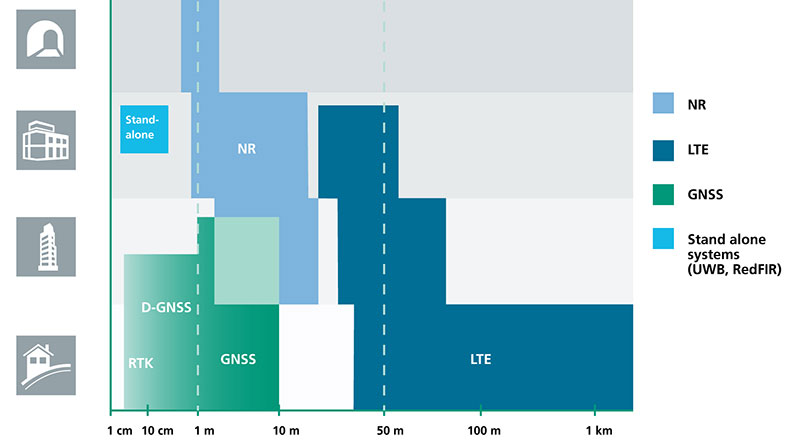
    The network has enhanced GNSS accuracy and integrity with protection levels to increase the safety and reliability of autonomous driving systems.

    It is an efficient and secure broadcast service for critical security patches and OTA updates to software and firmware in Telematics Control Units (TCUs), Electronics Control Units (ECUs), and Head Units (HUs), as well as map tile and map layer data. It also provides datacasting of traffic, weather, hazards, and other alerts.

    Global connectivity provides optimized routing of content and services.

    • Telematics. Increased coverage and reliability for ACN/eCall, roadside assistance, vehicle tracking and telemetry. Data can be pulled from vehicles for remote diagnostics, condition-based maintenance, and preventative analytics.
    • Managed Security. Secure link for global certifcate and key management, audits and compliance monitoring, that aslo enables service to patch vulnerabilities, and update firewalls and intrusion detection systems (IDS).

    www.globalstar.com
    phone: 877-452-5782


    Cohda Wireless

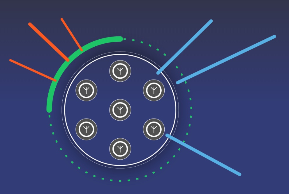
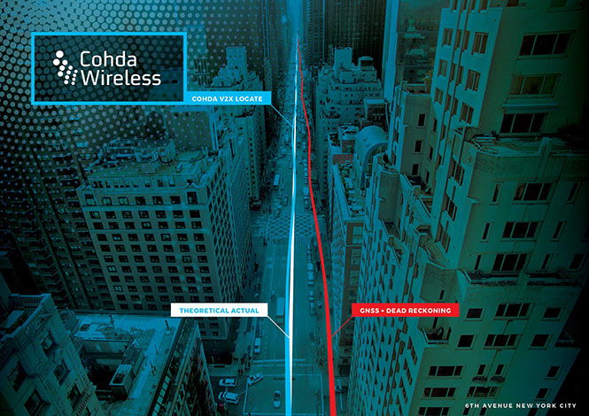
    The vehicle-based system V2X-Locate can identify vehicle position to sub-meter accuracy in environments that degrade GPS accuracy, such as tunnels and underground carparks, and between high-rise buildings.

    As well as enhancing current connected vehicles, V2X-Locate delivers a critical component for connected autonomous vehicles (CAV), which will require uninterrupted positioning data to safely navigate on roads. V2X-Locate enables equipped vehicles to identify their location using existing Smart City V2X (vehicle-to-everything) roadside infrastructure from any standards-based manufacturer.

    V2X-Locate positions the vehicle with sub-meter accuracy by using existing communications signals produced by V2X Smart City infrastructure deployments. The result is that V2X-Locate can eliminate positioning black spots in city centers.

    www.cohdawireless.com


    Telenav

    The In-Car Advertising Platform enables automotive OEMs to generate revenue by delivering ads to cars in a safe, user-friendly and contextually relevant way. The end-to-end offering for OEM partners is powered by Telenav’s In-Car Ads SDK (software development kit) and cloud-based intelligent targeting platform.

    To ensure driver safety, ads only appear when the vehicle is stopped, such as at car startup, traffic lights and upon arrival. The ads automatically disappear whenever the car is in motion or when users interact with other in-dash functions such as music or phone calls.

    Relevant ads such as coupons and recommendations are delivered to customers based on information from the vehicle, including frequently traveled routes, destinations and time of the day. For instance, when the vehicle is low on gas, the platform points out nearby stations along the driver’s route, potentially with discount offers.

    www.telenav.com


    Danlaw

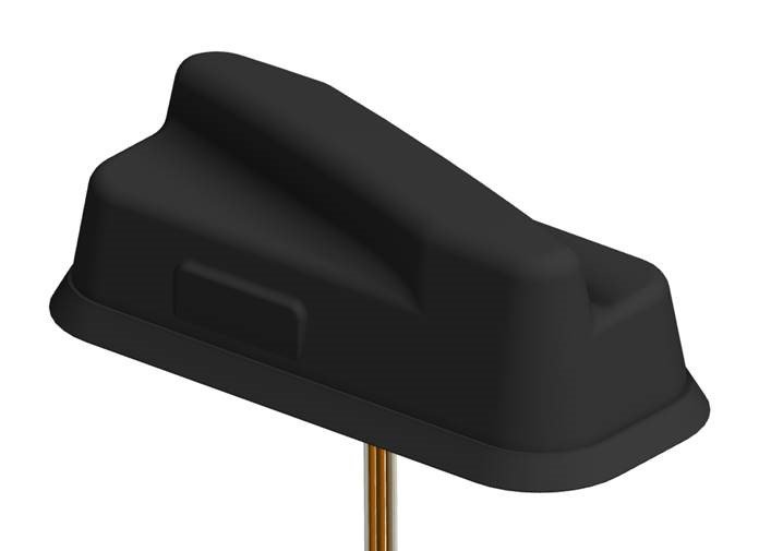
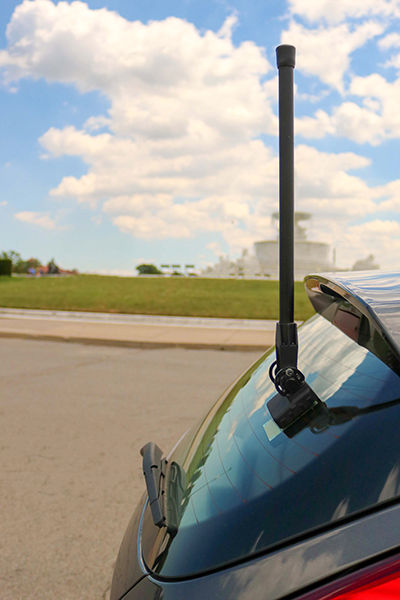
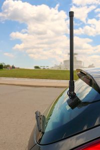
    The Through Glass Integrated V2X Antenna is designed for vehicle-to-vehicle and vehicle-to-everything (V2X) communications. The design incorporates an integrated GNSS antenna on the interior coupler. The antenna pairs with dedicated short-range communications (DSRC) devices.

    The dual-radio, glass-mounted antenna eliminates the risk of damaging the vehicle by using a coupling pair to pass DSRC signals between the vehicle’s interior and exterior, eliminating the need to pass RF cables through the roof or window opening. It antenna can be mounted on the rear, front or side windows using automotive-grade glass adhesive. Flexible installation allows the shortest cable route to the V2X device, reducing signal losses due to cable length.

    www.danlawinc.com

  • PNT Roundup: Positioning integral to system design of 5G cellular networks

    PNT Roundup: Positioning integral to system design of 5G cellular networks

    The cellular 5G standard targets latencies under 1 millisecond, data rates of up to 10 gigabits per second, extremely high network reliability and better accuracy in positioning. With location awareness becoming an essential feature in many new markets, positioning is considered as an integral part of the system design of upcoming 5G mobile networks.

    The cellular industry is currently implementing Long-Term Evolution (LTE)-Advanced, which might be called “4G” mobile broadband. Simultaneously, the industry is preparing the next step, a fifth-generation (5G) system. It will process communication 10 times faster than 4G, according to experts. 5G rollout will be complete in many international metropolitan areas by 2020.

    Positioning Performance for 5G NR and other technologies in different environments. (Image: Fraunhofer IIS)
    Positioning Performance for 5G NR and other technologies in different environments. (Image: Fraunhofer IIS)

    Adaptive array antennas

    In addition to the precise positioning it will afford, 5G shares another characteristic with GPS/GNSS: adaptive array antennas for digital beamforming (DBF). Adaptive arrays have many advantages for PNT, primarily in mitigation for multipath, jamming and spoofing.

    Adaptive antenna arrays with DBF are becoming increasingly important for PNT in challenging signal environments. DBF combines multiple antenna inputs to generate gain in arrival direction of the desired satellite signal and to create spatial nulls in the direction of jamming. (See the January 2017 Innovation column “Correlator beamforming for low-cost multipath mitigation” and the February follow-up, “Mitigating interference with a dual-polarized antenna array in a real environment.”)

    Picocells

    Emerging applications of DBF in 5G involve dense networks of picocells, small cellular base stations that typically cover a small indoor area. Picocells extend coverage where outdoor signals do not reach well, and add network capacity in areas with very dense phone usage. 5G architectures will use adaptive array technology to achieve high data rates, spectrum reuse and communications robustness.

    The implications for PNT are that 5G will require improved (relative) PNT to operate effectively, and picocells will be a source of PNT information in constrained environments.

    5G involves massive directional communications via multiple-input, multiple-output (MIMO), enabling high-bandwidth communications in fading (multipath) channels by using multiple antenna inputs to adapt to channels. It can do this without knowledge of user location, but it adds to the processing complexity. The directional capability can enable multiple users to be serviced in a picocell at different frequencies, while permitting spectrum re-use by nearby picocells through narrow beamwidth and the limited range of millimeter-wave (mmWave) frequencies.

    The PNT implications of 5G architectures, according to Gary McGraw of Rockwell Collins, are that 5G picocells will be synergistic with PNT in challenged environments — naturally, indoor and dense urban. They will necessitate development of distributed, networked PNT processing and infrastructure.

    Fraunhofer

    The 5G positioning framework will integrate a multitude of sensors into a hybrid positioning scheme, according to the Fraunhofer Institute for Integrated Circuits (IIS) in Germany. Fraunhofer IIS is currently prototyping low-latency and high-precision positioning systems for legacy LTE and future 5G New Radio (5G NR).

    5G NR enables positioning by providing high bandwidths for precise timing, new frequency bands at mmWave, massive MIMO for accurate angle-of-arrival estimation and new architectural options that support positioning. Improved accuracy, robustness and latency can be achieved, according to the institute.
    5G provides fast and reliable access to moving objects to achieve time-critical process control and optimization in industrial environments. Increased contextual awareness of goods, parts, machines and workers will enable new interaction and collaboration, the institute said.