Testing GNSS receiver systems in real-world conditions is limited by unpredictability, legal restrictions, and the inability to replicate scenarios. CAST Navigation addresses this challenge with advanced simulation technology that creates controlled, repeatable satellite signal environments.
When testing a GNSS, comprehensive testing usually isn’t possible when relying on live satellite signals, according to CAST Navigation. In a live environment, engineers can’t determine the exact cause of errors, which can slow development and increase risk, so it’s impossible to establish controlled conditions suitable for experimentation and isolate specific variables without using a controlled signal environment.
A valid experiment requires repetition of identical scenarios because it enables engineers to validate assumptions, debug faults and compare performance. Without this consistent verification, it’s impossible to put confidence in a satellite system, CAST Navigation said.
Also, certain GNSS conditions can’t be put into practice in the real world for testing purposes. For example, spoofing or jamming satellite signals is usually illegal because such activities could cause interference or harm in other systems. Also, environmental effects like atmospheric interference or terrain obstruction can’t be easily configured or isolated in a live testing scenario.
Improving reliable testing
A controlled simulation environment that can generate repeatable GNSS conditions enables engineers to conduct reliable testing and validation. CAST Navigationprovides such a highly realistic and reliable simulated satellite signal environment, enabling organizations to conduct rigorous testing of guidance systems and positioning technologies. By creating artificial signals that can be precisely repeated as many times as necessary, engineers can get the data they need without the difficulties and restrictions of operating in a real-world environment.
Multi-constellation frequencies available
At the core of this technology from CAST Navigation is the ability to generate multi-constellation GNSS signals across multiple frequencies, such as GPS, GLONASS and BeiDou. These systems are highly adaptable to all kinds of experimental conditions. They support simultaneous simulation of multiple satellite systems at once, allowing engineers to account for variables like terrestrial movement and space-based trajectories.
Using advanced motion modeling, engineers can use CAST’s system to simulate position, orientation and complex motion patterns in real time. But CAST Navigation technology isn’t just modeling satellite movement. It’s also modeling the environment the satellites are operating in, with variables such as atmospheric interference (such as ionospheric delay) fully integrated into the testing environment.
Engineers can test their production systems in both ideal and adverse environments, such as one where satellite signals are being jammed. This makes CAST Navigation systems suitable for both military and commercial applications, particularly when engineers are trying to design resilient and flexible GNSS systems.
GNSS receivers combined with inertial navigation systems (INS) have been widely applied to various mobile platforms.
However, in Arctic regions, GNSS positioning accuracy is severely degraded from low satellite elevation angles, frequent ionospheric disturbances, and insufficient visible satellites.
Moreover, the limited validation of existing onboard navigation systems further exacerbates the challenges of Arctic navigation.
To address these issues, a new research paper describes a hybrid neural network model based on temporal convolutional networks (TCN) and long short-term memory (LSTM) networks. The hybrid solution has been tested in the Artic with successful results.
The paper, “Robust GNSS/INS Integrated Navigation in Arctic GNSS-Challenged Environments Based on TCN-LSTM and MDAREKF,” is authored by Wei Liu, Tengfei Qi, Yuan Hu, Kaiwei Zhu, Tsung-Hsuan Hsieh and Shengzheng Wang of Shanghai Maritime University (DOI 10.1088/1361-6501/ae5279).
The proposal combines the pseudo-measurement information of GNSS predicted by the model with INS for integrated navigation to compensate for the interruption of GNSS and correct the error of INS.
Considering the potential bias in predicted pseudomeasurements, an adaptive robust extended Kalman filter (AREKF) algorithm based on Mahalanobis distance is further developed to dynamically adjust the innovation covariance matrix, thereby enhancing filter robustness.
Field experiments conducted on an Arctic survey vessel demonstrate that the proposed TCN-LSTM combined with AREKF significantly improves both the robustness and accuracy of integrated navigation under GNSS-constrained environments. In particular, during GNSS outages of 50 seconds, 140 seconds and 400 seconds, the proposed method reduces the horizontal root mean square error (RMSE) by 47%, 38% and 76% respectively.
Spirent Communications, now part of Keysight Technologies, has launched SimXTRACT, a GNSS test tool that bridges the gap between field and laboratory.
SimXTRACT enables signals captured in field environments to be comprehensively decomposed into individual, discrete signals and applied to lab simulation for realism at every stage of the development test cycle.
“By combining real-world insights with lab-based control and repeatability, our customers will no longer have to compromise on how they test in this fast-moving technology area,” said Peter Terry-Brown, divisional CEO of Spirent’s Positioning business. “SimXTRACT ensures customers get the best of both worlds, with enhanced realism delivering more accurate results, quicker issue resolution, and faster time to market.”
Developers usually rely on either RF record-and-playback or lab simulation for testing and validation of PNT systems and devices. While both methods play important roles in product development, neither is able to combine the richness of the real world with the control needed for tasks such as research and development, receiver integration, or regression testing.
The introduction of SimXTRACT brings the advantages of both field and lab test methods together by taking real signals captured in field environments and accurately breaking them apart to create realistic simulator drive data for use in Spirent simulators.
Using signals and scenarios captured in the field by Spirent record-and-playback devices, SimXTRACT performs complex signal decomposition, breaking down each received signal into discrete line-of-sight and multipath ray paths, along with metadata such as Doppler offset, code error, power level, and angle of arrival (AoA).
This decomposed environment is then automatically converted into fully controllable simulation scenarios for Spirent GNSS simulators, reducing time spent in the field, cutting the cost and complexity of scenario capture and generation, and enabling repeatable, high-fidelity testing.
Combined with the option for developers to analyze and understand signal recordings, as well as search for and recreate specific conditions in order to focus testing, SimXTRACT will help accelerate development workflows for sectors that include automotive, chipset, consumer devices, defense, critical infrastructure and more.
“In today’s high-precision PNT ecosystem, SimXTRACT redefines how you can develop, test and debug PNT-enabled systems,” said Terry-Brown. “You can now bring the real-world environment into every stage of your product realization process, saving you time and money, while also improving product quality.”
Safran Electronics & Defense has acquired Syntony GNSS, a simulator and receiver company founded in 2015 in Toulouse, France. The acquisition is intended to strengthen Safron’s resilient PNT innovations.
Under the agreement, signed Feb. 13, Safran will take 100% of Syntony’s share capital, subject to customary regulatory approvals. Financial terms were not disclosed.
A European leader in GNSS solutions for underground environments, Syntony has developed unique expertise to ensure reliable positioning in contexts where satellite signals are unavailable.
Syntony’s technology addresses a major challenge of satellite navigation systems: the vulnerability of GNSS signals to physical obstacles, jamming and interference. To tackle this, Syntony has developed several critical technologies, including:
Controlled reception pattern antennas (CRPAs) that make GNSS receivers less sensitive to jamming and spoofing — essential for flight safety and the protection of sensitive infrastructure.
Software-defined radio (SDR), a digital radio that can change function (switching from FM to Wi-Fi or GPS) through a simple software update without changing hardware, allowing it to adapt to threats or to changes in received or transmitted signals. It offers compactness and scalability, particularly suited to embedded systems and the requirements of modern operational environments.
In addition, Syntony develops GNSS receivers for next-generation satellites, particularly for low Earth orbit (LEO) constellations, further strengthening Safran Electronics & Defense’s offering in the space-based PNT and New Space sectors.
Syntony employs nearly 70 people across Toulouse and Paris.
For Safran Electronics & Defense, this acquisition makes it possible to offer more comprehensive equipment that is also more compact and energy-efficient, while remaining adaptable to the constant evolution of signals. These gains in weight and power consumption are essential for future civilian and military platforms (drones and counter-drone systems, missiles, aircraft and low-orbit satellites).
GMV is leading the development of a secure two-way satellite time and frequency transfer system under the European Space Agency’s TOUCAN project.
The initiative safeguards critical infrastructure by reducing reliance on GNSS and enhancing national positioning, navigation and timing (PNT) capabilities. Funded by the UK Space Agency through its membership in ESA’s Navigation Innovation and Support Program (NAVISP), the project is an important part of the UK Government’s Framework for Greater PNT Resilience.
Through a competitive process, GMV was selected to enhance the UK’s national capabilities in delivering nationally assured, secure and continuous PNT services for critical infrastructure, defense and the broader economy.
TOUCAN, the two-way satellite time and frequency transfer capability demonstration (TWSTFT), will draw on GMV’s expertise in time transfer and system-level engineering, reinforcing the company’s role in supporting the government’s PNT resilience efforts.
“ TOUCAN represents a strategic milestone for GMV. It underscores our commitment to delivering cutting-edge, nationally assured, PNT solutions that are vital to the UK’s critical infrastructure and national security,” said Mark Dumville, general manager of GMV in the UK.
eLoran support
TOUCAN complements efforts to reestablish a UK eLoran system, which will serve as a terrestrial backup to satellite-based services. A critical goal is to ensure that this system operates independently of the more vulnerable GNSS.
The project’s primary objective is to establish an accurate, independently verifiable TWSTFT link between the eLoran transmitter and the National Physical Laboratory (NPL), the UK’s official timekeeping authority. The new link will address GNSS-dependence within eLoran, maintaining a time traceable to UTC (NPL).
In addition, the system will provide a TWSTFT connection to a facility that operates an R&D timescale, a secure reference that will one day be essential for synchronizing operations, maintaining communication integrity, and supporting mission-critical systems.
“Precise and secure timing is at the heart of so much we rely on every day, from banking and transport to energy and communications,” said Paul Bate, CEO of the UK Space Agency. “This investment in UK satellite timing through TOUCAN is about more than technology; it’s about protecting the everyday services people and businesses depend on. By working with GMV, the PNT Office and ESA’s NAVIS program, we’re helping to build a stronger, more resilient space ecosystem that safeguards our security and keeps the UK at the forefront of innovation.
GMV is delivering the design, integration and operational demonstration of the system, building on its proven track record in delivering secure national timing products and infrastructure. Project partner Viasat is supplying satellite bandwidth, as well as supporting GMV in analyzing innovative TWSTFT technology evolutions.
The European Union PAVE-SCAN project aims to build European GNSS-based and AI-driven technologies to detect and assess roadway pavement problems.
The proposed project aims for the development to market (TRL8-9) of European GNSS-based integrated low-cost sensor technologies and artificial-intelligence-driven open-architecture software solution — machine learning (ML) and machine vision (MV) — for the detection, classification and georeferencing of roadway pavement surface anomalies, and for the low-cost assessment of roadway pavements using participatory sensing.
The proposed system is of practical importance because it provides continuous information about roadway pavement surface anomalies — valuable for efficiently monitoring the transport infrastructure and for public safety. The vision for roadway condition assessment using smartphone-like technology is under the hypothesis that such technology can be used for crowd-sourced data collection and analysis in GIS-based pavement management systems (PMS).
“The developed technology and related transport informatics are disruptive technologies that have the potential to reshape the transport and infrastructure industries,” according to the project description.
Near-real-time analysis and classification of roadway anomalies
WP3,WP4,WP5
2
Geospatial mapping of transport infrastructure, roadway anomalies and condition-assessment heatmaps
WP3,WP4,WP5
3
Geospatial mapping of transport infrastructure, roadway anomalies and condition-assessment heatmaps
WP3,WP4,WP5
4
Improved roadway management practices, prioritisation of public works & lower costs
WP4
5
Reduction in the transport-related environmental footprint through improved O&M of transport infrastructure and of mass transit
WP4,WP6,WP7
6
Reduction in roadway-assessment costs by utilization of a fleet of vehicles/buses as participatory sensors
WP5,WP6,WP7
7
Integration with national transport initiatives (e.g., National Single Access Point), & with Digital Twin platforms, for dynamically updated roadway-condition models, and improvements in transport safety through roadway improvements
WP4, WP5
8
Open-access data and APIs
WP1, WP8
9
Product to market and ‘Product as a Service’ (PaaS) business model
Today’s commercial innovation requires infrastructure that moves at the same pace.
Essence
The rise of commercial satnav
Everyday life is saturated with location-dependent devices. They are multiplying faster than ever and their requirements have surpassed what GPS can support. Innovation in low-Earth orbit (LEO) satellites have seen exponential growth in the last ten years, unlocking new possibilities in further connecting our world.
In 2016, the total number of satellites operational in space from commercial and government operators was approximately 1,500. This number had been stable for decades, with linear growth since the launch of Sputnik in 1957. Today, there are now more than 8,000 satellites operational in space — with nearly all growth happening in LEO.
There are multiple reasons why. The cost of space access has decreased with reusable rockets and greater competition. The demand for connectivity has driven deployment of multiple constellations to deliver Internet from space. Latency is extremely important in communications and resolution in Earth observation.
While innovation in LEO satellites has primarily focused on connectivity and Earth observation, there is a generational opportunity to innovate in the position, navigation and timing (PNT) infrastructure that silently powers modern life.
There are now more than ten entities working toward deployment of dedicated PNT functions in LEO, amounting to more than 2,500 satellites if every constellation was complete today. As shown in Figure 1, five of these entities have already collectively launched more than 50 satellites. This market signal is not surprising, as demand for greater precision, power and protection are becoming fulfilled with diversification in LEO.
Figure 1. Launches of LEO PNT satellites.
Essentials
Medium-Earth orbit (MEO) has been the traditional choice of satellite navigation for global systems, with GPS, Galileo, BeiDou and GLONASS all being deployed in this regime. This altitude in the outer Van Allen belts is the harshest radiation environment Earth orbit satellites are subjected to and is a major driver in the cost and complexity of the satellites. From a commercial standpoint, deployment in LEO is more attractive as the more benign radiation environment allows for the use of more commercial off-the-shelf (COTS) parts in satellite designs, facilitating volume production. With a healthy ecosystem and supply chain now developed around LEO for both satellites and launch vehicles, the opportunity for commercial PNT to set a new standard in performance and protection is open.
The time for innovation in PNT could not be more urgent. Innovators are pushing the frontiers of technology across every industry and market. Physical intelligence is proliferating in the form of self-driving cars, humanoid robotics, automated farming, unmanned aerial systems and more. As these systems begin to coexist in the real world, the tools they rely on have never been more at risk. Commercial aviation is regularly jammed in Europe and the Middle East due to ongoing conflicts. And ships at sea are struggling to adapt to an environment where spoofing is commonplace.
The commercial world has different and increasingly more stringent requirements than government-focused systems like GPS. GPS was designed primarily around military requirements and is longstanding infrastructure that is difficult to change with the myriad number of deployed devices that depend on it. This responsibility makes GPS too big to fail, but also incredibly difficult to change.
GNSS infrastructure has unlocked so much in commercial activity. There are now more devices using GNSS than the Internet, and GPS is by far the majority user of the technology (based on nearly 7 billion active GNSS devices on Earth and around 6 billion users of the Internet.) However, commercial users have limited input to the evolution of GNSS constellations, which has led to a widening gap between technology and wants, which provides for the current commercial opportunity.
Simply put, today’s commercial innovation requires commercial infrastructure that moves at the same pace to support.
Elements
Architecting LEO PNT
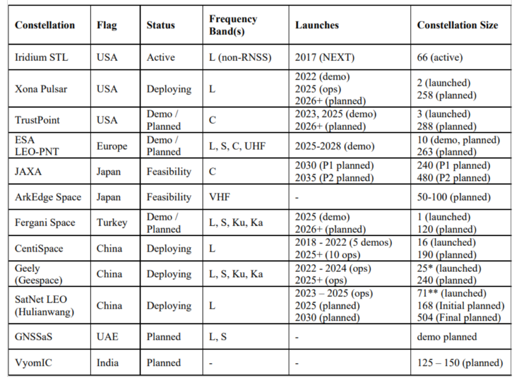
For a LEO satellite navigation system, many designs could be considered, as reflected in Table 1 from Reid et al. (2025) outlining current public information about systems already announced. These constellations range from government-supported systems, which could act as extensions of already deployed global or regional systems, to commercial systems that target potentially unique, independent markets.
Table 1. Comparison of dedicated LEO PNT systems, deployments, and plans. Note that satellites already deployed were verified on celestrack.org .
These constellations all have one thing in common: they aim for between 200 and 300 LEO satellites. The reason is simple: as LEO satellites have a footprint of approximately 1/10th that of medium Earth orbit (MEO) satellites, and between 20 and 30 MEOs are required for global PNT, approximately 10x more LEOs are needed to obtain similar coverage. A consequence is that in LEO, the radio energy is spread over 1/10th the area compared to MEO, which has implications for power needs at the satellite — 10x less in LEO for the same MEO power in the same band.
There is another crucial parameter to consider in LEO PNT design: spectrum. Table 1 shows that many approaches are being considered. Xona’s approach with its Pulsar constellation was centered around three major areas of commercial appeal: seamless operation with existing devices; increased native accuracy; and added resilience to jamming and spoofing. An important philosophy adopted early in the company’s culture was to not make development a science project — that is, do not reinvent the wheel, but rather upgrade the engine. GPS was a revolutionary technology, which is why it is so heavily adopted and brings so much value to the world. Therefore, stand on the shoulders of this giant to look out to the future.
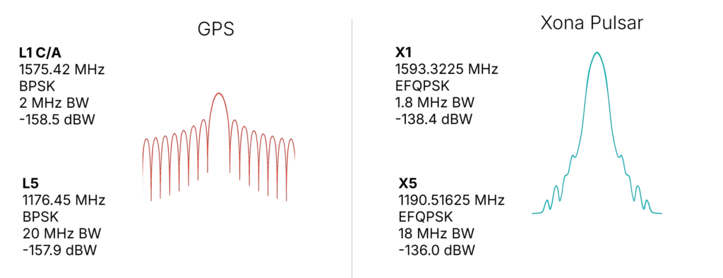
Ease of integration was the first consideration, as it has been the most important aspect in accelerating adoption of any new system. And spectrum is key to Integration. By launching a new system that uses the existing L-band signals, the GNSS ecosystem producing approximately one billion new units per year can seamlessly upgrade their capability without new hardware. Xona’s first technology pathfinder satellite in 2022 validated this hypothesis. While the pathfinder mission supported two satellite frequencies already in the regional navigation satellite system (RNSS) bands — one near L-band E6 and the other in the yet unused C-band near 5 GHz — it became apparent that receiver companies were willing to develop hardware for the L-band signal, and did so quickly with their existing hardware. There was resistance and longer timelines to global adoption for C-band signals.
In response, Xona shifted the production signals to a dual L-band system, which already has nearly a dozen commercial receiver partners tracking the recently launched production satellite — some within weeks of the launch. The challenge is to choose a waveform that is near existing GNSS bands, familiar in form and function and digital signal processing techniques to what is already fielded today, and to not cause harmful interference to the existing GNSS services in orbit. The resulting design is shown in Figure 2, on the right. The key innovation was the selection of a bandwidth efficient form of quadrature phase shift keying (QPSK), which focuses the energy in the central lobe and rolls off quickly compared to a traditional binary phase shift keying (BPSK) signal, shown in Figure 2 on the left for comparison. The result is a 100x stronger signal that does not cause harmful interference to existing GNSS signals, while offering resilience through more signal power. This selection process was iterative, taking feedback from the receiver community. More information on the design and testing for compatibility can be found in Reid et al. (2025).
Figure 2. (Left) GPS BPSK-based signal waveform, and (right) Pulsar QPSK-based signal waveform.
In addition to compatibility and ease of integration, accuracy and resilience are critical design drivers. For example, farmers rely on their equipment positional accuracy to efficiently distribute seeds, fertilizer and water, reducing waste and improving crop yields. Positional accuracy also enables accurate, repeatable field operations year after year, saving time, fuel and money while protecting the soil. Because GNSS typically offers meter-level positioning, today many farmers buy positional accuracy through GNSS correction services to obtain centimeter-level positioning. The Xona architecture leverages these techniques in precise point positioning (PPP), delivering precise ephemerides direct from the space segment, and combining them with the fast motion from LEO satellites (compared to MEOs) to reduce position solution convergence times from ~10 minutes to nearly instantaneous (see, for example, Mah and O’Keefe, 2025). This geometry also boosts coverage, as correction services today typically rely on geostationary satellites and do not service high latitudes, where they would benefit missions such as mining operations for critical minerals and polar navigation.
Connectivity relies on resilient timing. Passing more data through a network means efficiently meshing data packets in synchronized manner. Telecommunications and data centers need such connectivity to function. Authentication is expected in our communications systems, which is largely unavailable in civil GNSS signals. In an age where GNSS spoofing is done to cheat at games like Pokémon Go and now more frequently for nefarious purposes, authentication becomes essential for a modern system (Anderson, 2025, and Xona, 2025a). For resilience to spoofing, Xona included not just data authentication, but also range authentication, so that users can ultimately authenticate their position.
Defense applications require resilience to jamming. World conflicts, particularly currently in Ukraine and the Middle East, have showcased GNSS vulnerabilities in the presence of widespread GNSS jammers. However, this problem is no longer only a defense issue. In 2025, nearly 123,000 commercial flights in Europe were disrupted between January and April alone by GNSS jamming (GPS World, 2025). For resilience to jamming, one method is more power. LEO being 20x closer to Earth than MEO affords nearly a 10x boost in power for the same power transmitted at the satellite. Xona’s target was 100x more power to the end user to significantly reduce the effective range of a jammer by more than six times as shown by recent field trials. Such a transmission power translates to a >97% reduction in affected area and means threats shift to larger and less practical platforms for adversaries, i.e., from requiring handheld devices to backpacks or even truck-sized jammers.
More signal power also has implications for indoor positioning. Internet of things (IoT) devices such as asset trackers are commonly affected by signal obstruction and attenuation during transit, particularly in indoor environments, urban canyons, under foliage, or when obstructed by vehicles and cargo. Warehouses, shipping containers, and other constraints limit where position can be determined. Even coarse indoor positions can support operational intelligence for asset management.
Launching LEO PNT
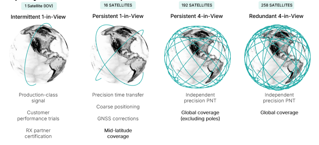
Pulsar is designed to launch in stages as shown in Figure 3, which unlocks capability in tranches that expands the number of features and ultimately the user base. While Pulsar will achieve persistent coverage across major markets at the deployment of 16 operational satellites, earliest customers in time transfer will see value from Pulsar much sooner as an independent source of timing synchronization for devices with holdover clocks. At 16 satellites, Pulsar will achieve persistent 1-satellite-in-view service, unlocking precise time transfer and coarse positioning for stationary users, including indoors. Pulsar also provides a link to stream GNSS corrections, building on a partnership with Trimble. Full resilient positioning will come online with GPS-level satellite visibility. First in the midlatitudes, with 192 satellites, and then globally with the deployment of an additional 66 satellites into polar orbit, bringing the total to 258 operational satellites.
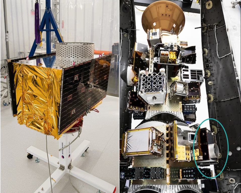
Xona launched its in-orbit-validation stage in June 2025 with Pulsar-0, the first production-class satellite representative of the scaled capability in terms of signal modulation, power and features. Pulsar-0 allowed for performance validation of the complete system, not just of the payload in space but also the tangible benefit to users on the ground. For scale, Figure 4 shows the 150 kg class satellite pre-launch, including its integration on the Falcon 9 launch vehicle. Launch cost has been become more accessible, unlocking the ability to launch larger spacecraft by commercial entities, which can have larger positive impact on the ground (Xona, 2025b).
Figure 4. Xona’s first production satellite Pulsar-0.
LEO PNT on-orbit
In almost 6 months since launch, Pulsar-0 has been tracked in more than 6 countries, 12 third-party receiver protypes, and has achieved several performance milestones that signal the groundbreaking capability Pulsar will deliver to users everywhere when the full constellation is operational. Early performance tests are built to showcase the value and features most important to commercial users in realistic settings.
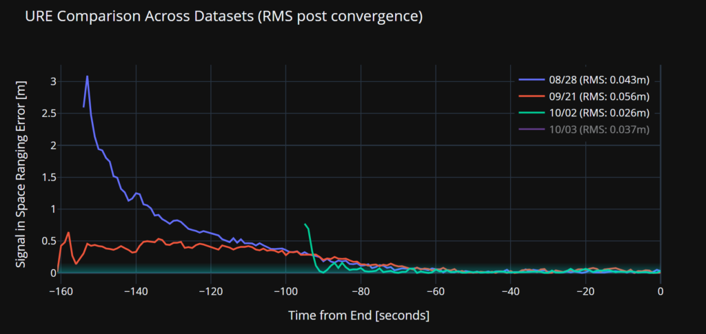
Accuracy. Figure 5 illustrates a signal-in-space user-range-error (SISRE) of 43 mm — about the diameter of a golf ball. This performance represents a more than tenfold increase in accuracy compared to that reported by GPS (Refro et al., 2024). The implication is an ability to natively perform PPP at the centimeter level, without an additional data link or correction layer.
Figure 5. Estimate of SISRE for Pulsar-0 ranging signal compared with nominal GPS.
Security. Xona is the first organization to show pseudorange authentication from orbit, accomplished using the Pulsar-0 satellite within weeks of the launch (Anderson, 2025). Pulsar is built from the ground up to be secure by design, combining cryptographic authentication of both navigation data and satellite ranging signals with rapidly authenticated signal verification — aiming for a time-to-authentication of approximately four seconds. This layered security significantly raises the technical and financial bar for would-be spoofers. A spoofer spoofing a single satellite continuously should succeed in fooling one second of a Pulsar receiver’s ranging once every 130 years (Xona, 2025a).
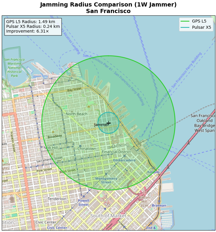
Jamming. Pulsar-0 signal testing has been conducted under live-sky jamming conditions at several jamming events, including Jammertest 2025 in Norway. These campaigns confirmed that using the Pulsar X5 signal can reduce the effective radius of a jammer by 6.3 times as compared to GPS L5 — in other words, less than 3% of the affected area compared to GPS. The same targeted power, bandwidth and type of jammer waveform was used against GPS and Pulsar, including center frequency. For context, Figure 6 shows the implications for a 1 Watt jammer scenario in San Francisco and the reduction brought by a 6.3x reduction in radius.
Figure 6. ffective jamming areas for Pulsar X5 and GPS L5 from a 1 W jammer in San Francisco based on Jammerfest 2025 test results.
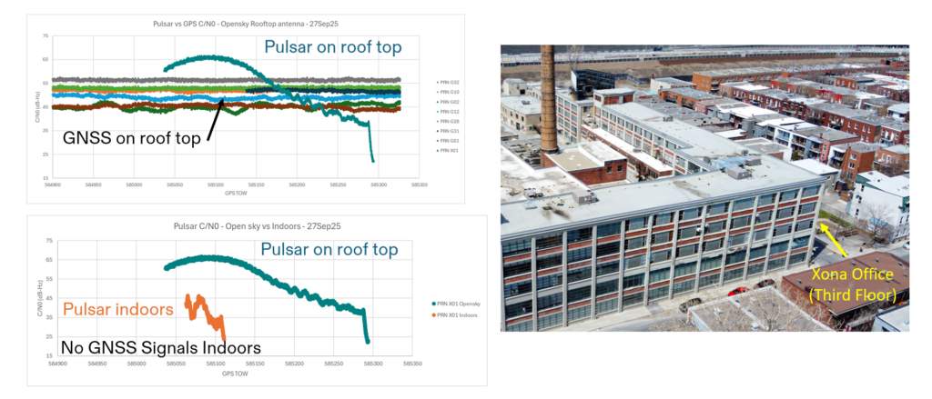
Indoor. Data were collected for several navigation passes per day at multiple locations, including indoors. These include passes at Xona headquarters in Burlingame, California, and its office in Montreal, Canada. The most challenging indoor environment was Montreal, on the third floor of an industrial and primarily concrete building with two floors above. Figure 7 shows the Pulsar-0 power profile during a typical pass, peaking at the highest point in the sky. This structure is an artifact of the antenna gain pattern used in this mission. Designed for a higher altitude for deployment of later satellites, the pattern will be more isotropic with future satellites launched near 1100 km altitude compared to Pulsar-0, which is closer to 500 km. Near apex, the signal penetrates indoors, and this short segment proves to be sufficient for indoor positioning for stationary users. Leveraging techniques based on Doppler and including pseudorange, early results indicate sub-10 meters both outdoors and indoors.
Figure 7. Comparison of Pulsar and GPS signal strengths on roof and indoors at the Xona Montreal office.
EVOLUTIONARY
The coming years will be about gaining operational experience and in scaling the constellation with a near-term focus on the first batch of 16 satellites. Pulsar-0 has already confirmed its value proposition: attaining major milestones in performance including accuracy, security and jamming, but perhaps most importantly in the integration of user equipment. The next year is about working with customers in specific industries and use cases as Xona moves towards deployment of early operational service.
The future of LEO PNT is bright. Theory has evolved to prediction, which is now evolving to reality. The early results appear to lead to an exciting PNT future with LEO PNT expanding the GNSS revolution in terms of security, interference mitigation and system availability both outdoors and indoors for a myriad of current and new applications and users.
Further Reading
Anderson J (2025). World’s First Authenticated Satellite Pseudorange from Orbit, Proceedings of the 38th International Technical Meeting of the Satellite Division of The Institute of Navigation (ION GNSS+ 2025), Baltimore, Maryland, September 2025, pp. 738-748.
Eissfeller B, Pany T, Dötterböck D and Förstner R (2024). A Comparative Study of LEO-PNT Systems and Concepts, Proceedings of the ION 2024 Pacific PNT Meeting, Honolulu, Hawaii, April 2024, pp. 758-782.
Li W, Yang Q, Du X, Li M, Zhao Q, Yang L, Qin Y, Chang C, Wang Y, Qin G (2024). LEO augmented precise point positioning using real observations from two CENTISPACE™ experimental satellites. GPS Solutions, 28(1): 44.
Mah C, O’Keefe K (2025). Hardware Simulation of Low-Earth-Orbit GNSS for Carrier Phase Ambiguity Resolution, Proceedings of the 38th International Technical Meeting of the Satellite Division of The Institute of Navigation (ION GNSS+ 2025), Baltimore, Maryland, September 2025, pp. 2431-2443.
Prol FS, Ferre RM, Saleem Z, Välisuo P, Pinell C, Lohan ES, Elsanhoury M, Elmusrati M, Islam S, Çelikbilek K, Selvan K, Yliaho J, Rutledge K, Ojala A, Ferranti L, Praks J, Bhuiyan MZH, Kaasalainen S and Kuusniemi H (2022). Position, Navigation, and Timing (PNT) Through Low Earth Orbit (LEO) Satellites: A Survey on Current Status, Challenges, and Opportunities, IEEE Access, (10): 83971-84002
Reid TGR, Chan B, Goel A, Gunning K, Manning B, Martin J, Neish A, Perkins A and Tarantino (2020). Satellite Navigation for the Age of Autonomy, 2020 IEEE/ION Position, Location and Navigation Symposium (PLANS), Portland, Oregon, April 2020, pp. 342-352.
Reid TGR, Gala M, Favreau M, Kriezis A, O’Meara M, Pant A, Tarantino P and Youn C (2025). Xona Pulsar Compatibility with GNSS. Proceedings of the 38th International Technical Meeting of the Satellite Division of The Institute of Navigation (ION GNSS+ 2025), Baltimore, Maryland, September 2025, pp. 929-943.
Reid TG, Neish AM, Walter T and Enge PK (2018). Broadband LEO constellations for navigation. NAVIGATION: Journal of the Institute of Navigation, 65(2): 205-20.
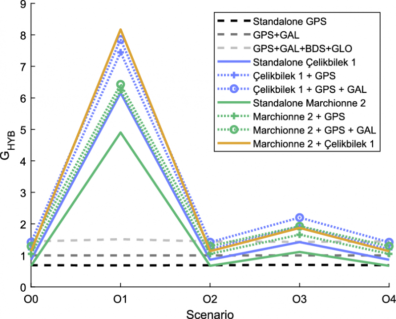
Low-Earth orbit (LEO) systems have emerged as a promising complement to GNSS, offering higher received power, better satellite geometry and broader spectrum options. Researchers aim to evaluate whether LEO-PNT can complement or enhance GNSS performance through large-scale simulations and design comparisons.
Researchers from Tampere University and Universitat Autònoma de Barcelona published (DOI: 10.1186/s43020-025-00186-5) a comparative analysis in the December 2025 issue of Satellite Navigation. The study investigates how different LEO constellation configurations perform in positioning accuracy and interference robustness when operating alone or jointly with GNSS.
Using semi-analytical modeling and 192,000 Monte Carlo simulations, the team evaluated 400 users across European regions in five outdoor scenarios. Key variables included carrier bands (1.5/5/10 GHz), effective isotropic radiated power (EIRP) levels and constellation geometry design.
The team simulated multiple standalone and hybrid constellation architectures, analysing carrier-to-noise ratio (C/N0), geometric dilution of precision (GDOP), position dilution of precision (PDOP) and lower bound 3D accuracy.
Results indicate that an EIRP of 50 dBm is sufficient for high-quality outdoor positioning when operating in L- and C-bands. While 10 GHz platforms require higher power to compensate for path loss, hybrid LEO + GNSS modes show markedly improved stability and reliability.
Multi-shell constellations such as Çelikbilek-1 and Marchionne-2 delivered a favorable balance between satellite count and global geometry, outperforming single-shell layouts. In harsh urban canyon conditions, GNSS accuracy degraded up to seven-fold, whereas LEO-PNT maintained stable ranging performance with limited loss.
Interference resistance also improved. Stronger LEO signal power means jammers require far greater intensity to cause equal degradation. Hybrid designs provided the most significant gains. Combinations such as Çelikbilek-1 + GPS/Galileo, or CentiSpace + BeiDou, yielded better PDOP distributions, faster fix availability and broader user coverage.
The authors conclude that LEO systems are not aimed at replacing GNSS, but rather to enhance availability and resilience under signal-challenged environments.
“Our results show that moderate-power LEO constellations can substantially strengthen outdoor positioning without requiring expensive satellite hardware,” the authors noted. “Geometry plays a major role — carefully designed multi-shell constellations achieve strong accuracy even with fewer satellites. As LEO-PNT develops, hybrid integration with GNSS offers the most cost-effective path toward secure, robust PNT solutions. This work provides guidance for future system designers evaluating frequency, transmission power and constellation configuration trade-offs.”
The findings suggest a realistic rollout pathway for resilient satellite navigation. LEO-enhanced PNT could benefit autonomous vehicles, UAV routing, emergency response, precision farming and critical infrastructure monitoring — especially where GNSS falters in interference-dense or high-rise environments.
Lower-power LEO transmission also reduces deployment cost, opening access for commercial operators.
Future work may assess indoor positioning potential, bandwidth expansion, and real-orbit testing to refine simulation assumptions. As global demand for secure PNT grows, the integration of LEO and GNSS could become a cornerstone for next-generation navigation technology.
The United Kingdom has issued a summary of input it requested on positioning, navigation and timing (PNT) technologies. The UK deems PNT resilience critical for the UK’s economy.
After a call for evidence, the UK Department for Science, Innovation & Technology received 128 responses from business, industry, academics and the public. These views on opportunities and challenges for the UK’s PNT industry are gathered in a document available online.
Key themes identified
A viable market exists for GNSS-independent PNT, with respondents citing applications in defense and critical infrastructure.
Awareness of GNSS vulnerabilities in end users and critical infrastructure sectors is low.
Potential opportunities in GNSS-independent PNT and other technologies include eLoran, LEO-PNT, 5G, quantum PNT, inertial systems, and applications for GNSS-denied environments.
Short-term challenges include funding constraints and a lack of legislation and standards.
Long-term challenges include scalability, lack of sovereign manufacturing capability, and insufficient planning .
The industry is experiencing a skills shortage, especially in engineering, with a limited talent pipeline and lack of dedicated training opportunities.
In all, 128 responses were received from businesses (sellers and users of PNT), academics, industry bodies and the public. Respondents could select multiple sectors when describing their background; the defense sector was selected most frequently (39 responses), followed by space (35 responses), aviation and drones (28 responses), maritime (28 responses) and communications (27 responses).
Responses will be used, along with wider research, to inform future government policy interventions to support the UK PNT sector.
Spirent Communications, now part of Keysight Technologies, announced PNT Xe, a GNSS simulation platform designed to expand high-performance GNSS testing across the development lifecycle. The platform aims to reduce barriers to positioning, navigation and timing testing by offering simulation capabilities in what the company describes as an economical, multipurpose platform.
The company said PNT Xe addresses challenges manufacturers face in validating GNSS performance during accelerated development schedules. The platform’s hardware supports testing from early prototypes through production line verification for commercial and military applications.
“Until now, many organizations have been forced to use unreliable, inconsistent simulators or utilize ‘live sky’ signals as a way of conducting production testing,” said Peter Terry-Brown, divisional CEO of Spirent’s positioning business. He said PNT Xe makes the company’s simulation technology available for workstations, engineers and project phases.
Terry-Brown said the platform allows developers, integrators, design verification teams and production line testers to use consistent test methodology without compromising results validity. Many leading GNSS chipsets and modules are developed using Spirent’s simulators, he said.
The compact PNT Xe can be rack or desk mounted and features an interface designed to accelerate scenario creation. The platform can operate in lab or field environments and withstand variations in temperature and vibration while maintaining performance, according to the company. It supports all GNSS constellations and frequencies and includes AES M-Code access and a removable system disk for secure testing environments.
Rob VanBrunt, CEO of Spirent Federal Systems, called PNT Xe “a game-changer for defense customers.” He said the platform’s ease of use will help deploy new PNT technology faster, allowing software engineers to test code changes at their desks. Authorized GPS M-Code users can conduct unclassified military signal testing using AES M-Code without relying solely on secure labs, he said.
Marie Hattar, chief marketing officer at Keysight Technologies, said accurate, high-performance simulation becomes critical as positioning and timing technologies become foundational to 6G, defense systems and autonomous vehicles. PNT Xe makes that capability available to more innovators to validate performance, reliability and resilience at every development stage, she said.
Built on Spirent’s 40 years of expertise, PNT Xe is designed for development and production environments including low-altitude drones, vehicles, space applications, automotive, defense, and consumer devices.
Keysight Technologies Inc. completed its acquisition of Spirent Communications in a deal valued at $1.46 billion on a fully diluted basis. The acquisition expands Keysight’s software-based testing, network assurance and GNSS capabilities across multiple industries.
Spirent Communications provides automated test and assurance systems for network performance, cybersecurity and positioning. The company supports testing for 5G, SD-WAN, cloud and autonomous vehicle systems. By joining Keysight, Spirent adds network automation, lifecycle management and GNSS testing to the company’s product suite, enabling customers to manage system performance from design to deployment. The acquisition also strengthens Keysight’s position in areas including non-terrestrial networks, low-Earth orbit (LEO) satellite constellations and 6G development.
“Spirent’s industry-leading positioning technologies portfolio strengthens our end-to-end solutions across commercial communications and aerospace defense, especially as applications such as non-terrestrial networks, low Earth orbit constellations and emerging 6G standards gain traction over the next few years,” said Kailash Narayanan, senior vice president at Keysight Technologies.
Spirent’s shares will be delisted from the London Stock Exchange effective Oct. 17. Its operations and financial results will be integrated and reported within Keysight’s Communications Solutions Group. Spirent shareholders will receive $2.55 per share, comprising $2.50 in cash and a previously paid special dividend of $0.04 per share.
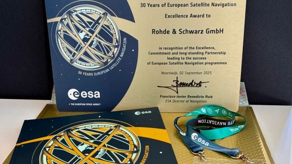
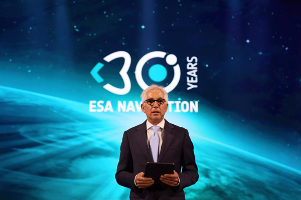
The European Space Agency (ESA) marked 30 years of European satellite navigation with a celebration Sep. 2 at its research and technology center. The event honored key contributors who have shaped the journey of systems like Galileo and EGNOS, which have positioned Europe as a global leader in satellite navigation.
Among the honorees was Rohde & Schwarz, recognized for the excellence, commitment and long-standing partnership leading to the success of European satellite navigation programs over the past three decades.
Javier Benedicto kicks off the celebration of 30 years of satellite navigation. (Photo: ESA)
The event brought together institutional and industrial partners, ESA Member State representatives, and leading figures in satellite navigation. The celebration revisited pivotal milestones in Europe’s satellite navigation history and looked ahead to future innovations.
A highlight of the evening was the award ceremony led by ESA Director of Navigation Javier Benedicto, who, alongside past directors, presented accolades to organizations and partners instrumental in this success story.
Rohde & Schwarz’s recognition underscores their role in advancing European satellite navigation technology. Their contributions have been vital in the development and operational success of Galileo and EGNOS, systems that have revolutionized positioning, navigation, and timing services across Europe and beyond.
The event not only celebrated past achievements but also set the stage for the future of European satellite navigation, with discussions around upcoming initiatives and advancements. For Rohde & Schwarz and other honourees, the evening served as both a celebration of past achievements and a call to continue building a connected, resilient, and sustainable future in space.
“Thirty years of satellite navigation is a testament to shared vision, determination to push technology boundaries, and intense, long-term collaboration,” said Rob Short, director of Business Development at Rohde & Schwarz. “We are honoured to have contributed to this remarkable achievement. Congratulations to everyone who made this milestone possible.”