The forum brings together experts from industry and regulatory authorities to discuss the future of network and spectrum monitoring in increasingly complex RF environments.
The forum will provide a full day of insights, technical exchange, and hands-on demonstrations. Rohde & Schwarz and its partners will present keynote addresses and expert presentations, and provide networking opportunities with professionals from across the network and spectrum monitoring ecosystem. Participants also can consult directly with Rohde & Schwarz technology specialists.
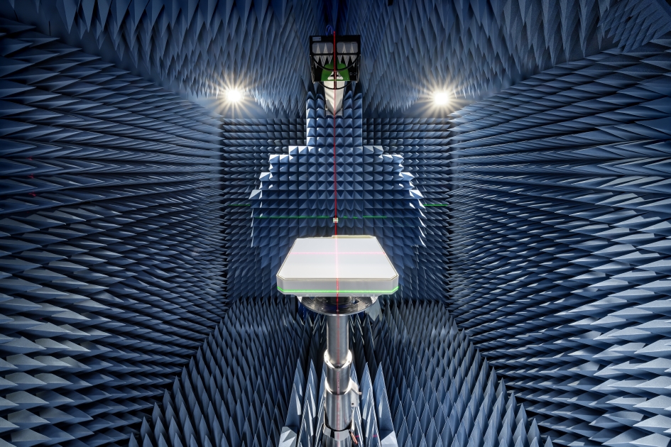
A joint measurement trial, Rohde & Schwarz and Greenerwave have demonstrated that a near-field system can record a full radiation pattern of a 50 cm Ku band electronically steerable array for a SATCOM antenna in a half hour.
The achieved results match simulation models within a decibel, making this approach a fast and reliable way to verify antenna performance.
For manufacturers of SATCOM systems facing large chamber constraints, it offers a clear path to quicker, more cost-effective testing.
Electronically steerable array (ESA) antennas are becoming key components in modern SATCOM systems. Accurate knowledge of their radiation pattern is required for reliable operation in LEO, MEO and GEO orbits. However, conventional far‑field testing demands chambers that are often larger than practical for Ku or Ka band antennas, especially when the aperture of the Antenna Under Test (AUT) reaches half a meter or more.
Compact Antenna Test Ranges (CATR), on the other hand, are still relatively large for these AUTs and require time-consuming dual-axis positioning of AUT to map the radiation pattern.
Rohde & Schwarz and Greenerwave have reached a breakthrough in ESA antenna testing in a joint measurement trial, achieving highly accurate radiation pattern characterization in the near field, significantly reducing measurement time. Greenerwave’s innovative SATCOM user terminals are based on reconfigurable intelligent surfaces (RIS), allowing the company to design electronically steerable antennas that deliver high-performance connectivity while reducing energy consumption and reliance on semiconductors compared with conventional solutions.
For the joint measurement campaign, Rohde & Schwarz provided its R&S TS8991 over‑the‑air and antenna measurement system, equipped with a conical cut positioner, and its R&S ZNA vector network analyzer. Together, they evaluated Greenerwave’s passive single‑aperture ESA that uses RIS technology for beamforming. The antenna under test (AUT) features a 50 x 50 cm aperture and is designed for low power consumption and easy integration.
The measurement covered an extended upper hemisphere down to a polar angle of 120 degrees, using a one-degree step size. Ten Ku band frequencies were recorded in a total of 32 minutes, thanks to the system’s hardware trigger function. Data was processed using the R&S AMS32 antenna measurement software, which applied a FIAFTA near-field-to-far-field transformation algorithm.
Comparison with the original simulation based on a numerical twin model and with results from Greenerwave’s CATR setup showed peak gain or directivity variations of max. 1 dB and typically 0.3 dB, validating the accuracy of the near-field solution. Export options allow users to continue analysis in tools such as CST Microwave Studio or MATLAB.
The trial shows that even large SATCOM antennas can be characterized quickly and accurately with the R&S TS8991 antenna test system from Rohde & Schwarz in a near-field setup, providing a practical alternative to large-sized far-field chambers or CATRs.
According to Rohde & Schwarz, the system setup can be used by other SATCOM makers testing broadband, IoT or back haul antennas for applications requiring flexible beam control and high data rates. The setup can be integrated more easily into research lab environments, and it shortens test cycles, reducing overall development cost.
FastXY can transform standard mobile devices into professional-grade data collection tools for geospatial information systems (GIS) and architecture, engineering and construction (AEC) professionals. FastXY offers professionals the ability to collect point, line and polygon data, and delivers advanced capabilities including 3D basemaps, construction staking, topographic surveying, on-the-fly datum transformations and survey-grade elevations. A built-in Bluetooth data parser allows users to configure the app to collect data from virtually any instrument supporting BLE Bluetooth or RS-232 — including echosounders, radiation sensors, laser rangefinders, barcode scanners and more — and marry that data instantly with precise GNSS coordinates. Available in free and premium versions.
Handheld scanner: Designed for BIM, indoor scanning and reality capture
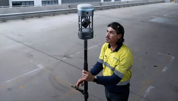
The RS7 handheld SLAM (simultaneous localization and mapping) scanning solution was built for BIM documentation, indoor surveying, renovation planning and complex spatial analysis. It is designed to help professionals capture high-density 3D data efficiently and convert it into practical deliverables through CHCNAV’s software and cloud ecosystem. The RS7 integrates a next-generation lidar scanner capable of measuring up to 1.15 million points per second. Its wide field of view (360° x 189°) supports comprehensive coverage of floors, walls and ceilings, helping reduce the need for repeated passes and complex capture maneuvers in tight or cluttered spaces. The scanner also includes a high-precision inertial measurement unit with bias stability better than 0.5°/h. By combining lidar and inertial data, the system is designed to maintain stable motion estimation and consistent point-cloud quality in environments that challenge many mobile workflows, including long corridors, repetitive structures, and feature-limited interiors.
Mobile scanner: All-in-one system offers SLAM, LIDAR, RTK and 360 degree imagery
The GX1 is an integrated, highly accurate all-in-one mobile scanning system combining simultaneous localization and mapping (SLAM), lidar, real-time kinematic (RTK) georeferencing, cameras and software. It supports a seamless workflow, from capture to deliverable, and can reduce the time required to survey a site by up to 95%. The independently validated global accuracy of 5 mm to 10 mm delivers the precision needed for topographic and road surveying, scan to building information models, construction progress tracking, and more. These capabilities are supported by integrated RTK georeferencing with real-time quality monitoring, four 20MP cameras for 360° panoramic imagery, and a proven SLAM algorithm. The GX1 has four deployment modes — backpack, survey pole, vehicle mount and supported handheld.
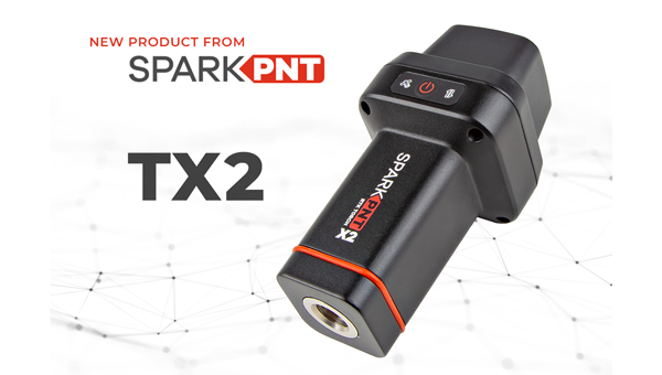
Quad-band GNSS rover: With support for Galileo high accuracy service
The SparkPNT TX2 quad-band GNSS rover combines an IP67-rated aluminum enclosure with support for Galileo’s High Accuracy Service (HAS) and standard RTK correction workflows. The receiver is built around the Quectel LG290P quad-band GNSS engine and supports multi-constellation tracking. Galileo HAS support provides sub-20 cm accuracy globally without subscription-based correction services, while RTK workflows via NTRIP or u-blox PointPerfect can achieve centimeter-level positioning. Battery life is rated at 50-plus hours, positioning the TX2 for multi-day field campaigns without recharging. The unit connects to iOS and Android devices via Bluetooth and WiFi, with compatibility reported for common GIS and data-collection applications. A notable design choice is the open-source firmware, which gives users visibility into how positioning data is processed and allows for customization and third-party integration. SparkFun has positioned this as an alternative to closed GNSS ecosystems where firmware and processing pipelines are not user-accessible.
Mobile
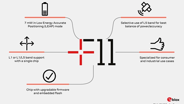
GNSS platform: Provides ultra-low power GNSS for all environments
The u-blox F11 platform provides L1/L5 dual-band standardprecision GNSS to improve positioning accuracy while reducing power consumption to as low as 7 mW in typical configurations. It combines ultra-low power operation with intelligent signal management to meet the evolving demands of tracking, wearables, telematics and mobility applications — including micromobility solutions and drones. The platform enables device manufacturers to achieve longer battery life, faster and more reliable position fixes, and greater design flexibility. Its situationally aware GNSS architecture, with integrated geofencing and indoor detections, dynamically balance accuracy and power consumption. By selectively using dual band L1/L5 operation only when it helps maintain positioning performance, the platform reduces energy use while providing resilience and maintaining confidence in location data.
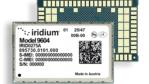
The Iridium 9604 is a compact, threein-one internet of things (IoT) module that integrates Iridium short burst data satellite service, LTE-M cellular connectivity, and GNSS positioning into a single platform. The Iridium 9604 seeks to make dual-mode IoT connectivity viable for price-sensitive, high-volume deployments. Built on the u blox SARA-R5 platform, the module comes in a compact 16 mm x 26 mm x 2.4 mm form factor, suitable for dual-mode IoT deployments across industrial, infrastructure and mobility applications.
L1+L5 GNSS modules: For trackers and high-precision IOT
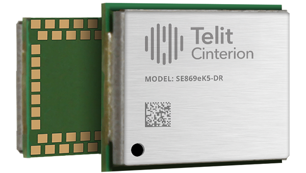
Two dual-band positioning modules built on Airoha’s AG3335 chipset series are available: the ultracompact SE873K5-D and the high-end SE869eK5-DRK. Both support space- and power-constrained IOT devices and use cases that require continuous, ultraprecise positioning. The modules provide a scalable path to adopt dual-band L1 + L5 GNSS.
Timing
Cesium-less clock: An alternative to cesium-accuracy holdover clocks
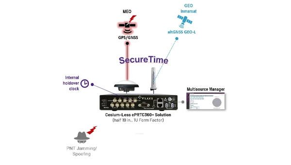
The patent-pending Cesium-less ePRTC360+ holdover solution is designed to safeguard atrisk infrastructure against the increased threat of GNSS timing disruptions. It is the only alternative to Cesium clocks to meet ITU-T G.8272.1 standards. It can protect critical power grids; transportation, aviation and public safety systems; 5G mobile networks; and AI data centers. It meets the international ITU-T G.8272.1 standard and has been successfully tested across a range of livesky defense and commercial jamming/spoofing environments. It has been integrated into VIAVI’s SecurePNT 6200 product series and can maintain 100 ns accuracy during GNSS-denied threats through the resilient altGNSS GEO-L service with no time limit.
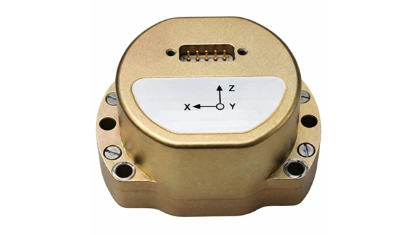
The U4930 series is a reliable and cost-effective six-axis microelectromechanical system (MEMS) and inertial measurement unit (IMU) module for navigation, control and measurement of vehicles, ships and drones. Applications include vehicle/ship attitude measurement, UAV attitude reference and trajectory control, mobile mapping, track inspection and underwater highprecision navigation. The U4930 series integrates high-performance MEMS gyroscopes and accelerometers within an independent structure. The three-axis MEMS gyroscopes sense the angular motion of the carrier, and the three-axis MEMS accelerometers sense the linear acceleration of the carrier. The system internally performs compensation for zero bias, scale factor, non-orthogonal error and acceleration-related terms across all temperature parameters, maintaining high measurement accuracy over a long period of time. The module supports custom communication protocols and provides synchronization for GPS/GNSS time data and pulse per second (PPS) signals.
Underground navigation: For navigating mines and unmapped environments
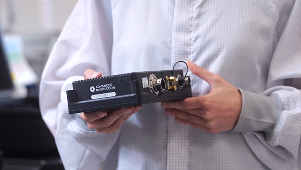
Chimera Land is a 3D laser velocity sensor (LVS) designed to solve the primary challenge for underground mining: maintaining precise vehicle positioning in deep, dark and unmapped environments where GPS cannot reach. When fused with an Advanced Navigation inertial navigation system (INS), Chimera Land allows underground vehicles to maintain stable navigation over extended distances and time. Instead of needing to query an external beacon or satellite for its location, the sensor uses specialized lasers to measure a vehicle’s ground-relative 3D velocity with high accuracy. By feeding this precise data into the vehicle’s INS, the sensor eliminates the drift that typically comes with standalone INS. Using AdNav Intelligence, the result is a resilient, high-performance, infrastructure-light positioning solution that excels in the highdust, zero-light conditions typical of underground mines.
Simulators
GNSS test tool: Provides real-world testing with signals from the field
The SimXTRACT GNSS test tool bridges the gap between field and laboratory. It enables signals captured in field environments to be comprehensively decomposed into individual, discrete signals and applied to lab simulation for realism at every stage of the development test cycle. Developers usually rely on either RF record-and-playback or lab simulation for testing and validation of PNT systems and devices. SimXTRACT takes real signals captured in field environments and performs complex signal decomposition, breaking down each received signal into discrete line-of-sight and multipath ray paths, along with metadata such as Doppler offset, code error, power level and angle of arrival. This decomposed environment is then automatically converted into fully controllable simulation scenarios for Spirent GNSS simulators.
Autonomous
Inertial measurement unit: For unmanned air, land and sea
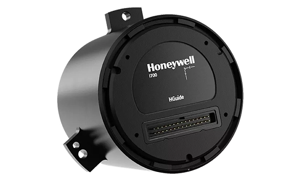
Honeywell launched the HGuide i700, an inertial measurement unit (IMU) that delivers high-accuracy performance for unmanned air, land and sea vehicles. By pairing near navigation-grade capability with a nolicense-required (NLR) classification, the HGuide i700 provides integrators worldwide with a new option for critical sensing and navigation. The HGuide i700 uses high reliability sensors and electronic architecture found in Honeywell’s HG3900 inertial measurement unit (IMU). Compact and low power, the HGuide i700 delivers near-navigationgrade accuracy and reliability while being optimized to support longer range navigation in GNSS-denied environments. The HGuide i700 offers strong GNSS-denied performance for by limiting maximum acceleration and spin rates in a license-free package. The latest in Honeywell’s HGuide suite of no-license inertial solutions, the HGuide i700 allows customers to streamline development cycles, simplify system architecture and transition to field deployment quickly. The HGuide i700’s rugged design, compact size and low-power profile make it suitable for diverse commercial, industrial and defense applications, including autonomous vehicles, mapping and surveying.
Anti-jam antenna system: Provides multi-constellation, multi-frequency GNSS signal protection
The GAJT-AE3 protects all major GNSS constellations from jamming with full multiconstellation, multi-frequency coverage, ensuring reliable PNT in demanding airborne environments. Its antenna electronics mitigate interference by creating up to seven nulls per band in the direction of jammers, providing significant anti-jam protection even in dynamic multi-jammer scenarios. The output is a protected radio frequency signal, free from jamming and suitable for input to modern and legacy GNSS receivers. The GAJT-AE3 protects and supports all GNSS frequencies, including L-band corrections and Iridium PNT.
OEM
GNSS board: All-band multifrequency reception and HAS-ready
Syslogic’s new all-band GNSS expansion board for rugged embedded computers is powered by the u-blox X20 receiver. It supports all major GNSS constellations and frequencies, including L1, L2, L5, L6 and L-band, and enables the use of the Galileo High Accuracy Service (HAS). It provides centimeter-level positioning, opening up new applications across industries such as autonomous field management, operation of construction machinery in remote areas, or navigation of automated guided vehicles and autonomous mobile robots. The GNSS board is designed for worldwide use. The integrated u-blox receiver supports modern correction techniques such as RTK, PPP-RTK and PPP. For the first time, it has been fully optimized for PointPerfect Global, u-blox’s proprietary high-precision GNSS correction service, delivering centimeter-level positioning anywhere in the world. This is particularly useful in remote areas without cellular coverage.
GNSS L1/L5 breakout: For meter-level positioning in embedded applications
The SparkFun GNSS L1/L5 Breakout – NEO-F10N (SMA) is a compact GNSS module designed for meter-level positioning accuracy in embedded applications. It uses dual-frequency L1 and L5 bands, with the L5 signal offering improved performance in urban environments due to reduced RF interference within the protected ARNS spectrum.
The board supports concurrent reception of GPS, Galileo and BeiDou, and uses u blox dual-band multipath mitigation to enhance accuracy in challenging conditions. It features a single UART interface, with an onboard CH340 USB-to-serial converter for easy connection to a computer, and standard pin headers for integration with external systems.
The module includes an SMA connector for secure antenna attachment and is configurable using u-blox u-center software.
The 23rd International Flight Inspection Symposium (IFIS) will gather experts in San Salvador May 4-8. There, Rohde & Schwarz will demonstrate its test and measurement solutions for ground-based navigation aids. The exhibits address the rising traffic volumes and stricter safety requirements.
Rohde & Schwarz will take part in the conference’s technical sessions with a presentation on “Challenges for UAV Operations in RF Dense Aerodrome Environments.”
The aviation sector today faces increasing air traffic density, rapid technological advancements and heightened security concerns, the company explained. Operators need test equipment that delivers laboratory level precision while tolerating the harsh environment of an airport runway or a remote navigation site.
Among the exhibits at the Rohde & Schwarz booth is the R&S EVSD1000 VHF/UHF Nav/Drone Analyzer, designed to conduct GBAS, ILS and VOR measurements in line with ICAO Doc 8071 and ICAO Annex 10. The receiver delivers laboratory precision, supports an air to ground Wi‑Fi datalink and gapless measurements with improved location accuracy during flight inspections. Customers benefit from a device that can be mounted on a drone, reducing the need for manned flights and lowering operational expenses.
Rohde & Schwarz gives airlines, airport operators and navigation service providers a reliable way to certify and maintain ground‑based aids under today’s demanding conditions. By combining high measurement accuracy, easy operation and durability, Rohde & Schwarz aims to help the industry keep pace with growth.
New test capability supports device manufacturers preparing for Xona’s commercial LEO navigation constellation.
Rohde & Schwarz is providing signal simulation capabilities supporting Pulsar, the next-generation satellite navigation service developed by Xona.
The new functionality enables manufacturers to test Pulsar capabilities in production settings using Rohde & Schwarz signal generators, providing an accessible pathway for validating and scaling devices with next-generation positioning, navigation and timing (PNT).
As demand grows for more precise and resilient navigation technology, the industry is preparing for a new generation of satellite signals. Xona’s Pulsar constellation, operating in low Earth orbit (LEO), is designed to complement existing GNSS infrastructure such as GPS by delivering stronger signals, improved accuracy, and enhanced resilience against threats and interference.
The capability will be available as a new software option for the R&S SMBV100B and R&S SMW200A vector signal generators, allowing engineers and manufacturers to test receiver compatibility with Pulsar signals as the new constellation enters scaled deployment. By adding Pulsar simulation to its test portfolio, Rohde & Schwarz enables device developers and manufacturers to begin validating compatibility with the emerging service.
“Navigation technology is entering a period of rapid evolution,” said Matt Hammond, North America satellite technology manager, Rohde & Schwarz. “By adding Pulsar signal simulation to our signal generator portfolio, Rohde & Schwarz is preparing our customers for the next evolution of satellite navigation. Our goal is to provide the scalable test infrastructure needed to bring these innovations from development into deployment.”
“Pulsar is designed to upgrade the global navigation infrastructure while remaining compatible with GNSS devices already in use today,” said Bryan Chan, co-founder and VP of strategy at Xona Space Systems. “Test and measurement solutions play an important role in enabling device manufacturers to evaluate compatibility as new signals become available. Rohde & Schwarz brings deep expertise in precision signal generation that helps make this possible.”
The R&S SMBV100B and R&S SMW200A vector signal generator will soon join Pulsar’s verified ecosystem program recognizing devices and testing solutions validated for compatibility with Pulsar signals. Rohde & Schwarz will showcase its navigation test solutions at Space Symposium 2026, taking place April 13-16 in Colorado Springs.
Testing GNSS receiver systems in real-world conditions is limited by unpredictability, legal restrictions, and the inability to replicate scenarios. CAST Navigation addresses this challenge with advanced simulation technology that creates controlled, repeatable satellite signal environments.
When testing a GNSS, comprehensive testing usually isn’t possible when relying on live satellite signals, according to CAST Navigation. In a live environment, engineers can’t determine the exact cause of errors, which can slow development and increase risk, so it’s impossible to establish controlled conditions suitable for experimentation and isolate specific variables without using a controlled signal environment.
A valid experiment requires repetition of identical scenarios because it enables engineers to validate assumptions, debug faults and compare performance. Without this consistent verification, it’s impossible to put confidence in a satellite system, CAST Navigation said.
Also, certain GNSS conditions can’t be put into practice in the real world for testing purposes. For example, spoofing or jamming satellite signals is usually illegal because such activities could cause interference or harm in other systems. Also, environmental effects like atmospheric interference or terrain obstruction can’t be easily configured or isolated in a live testing scenario.
Improving reliable testing
A controlled simulation environment that can generate repeatable GNSS conditions enables engineers to conduct reliable testing and validation. CAST Navigationprovides such a highly realistic and reliable simulated satellite signal environment, enabling organizations to conduct rigorous testing of guidance systems and positioning technologies. By creating artificial signals that can be precisely repeated as many times as necessary, engineers can get the data they need without the difficulties and restrictions of operating in a real-world environment.
Multi-constellation frequencies available
At the core of this technology from CAST Navigation is the ability to generate multi-constellation GNSS signals across multiple frequencies, such as GPS, GLONASS and BeiDou. These systems are highly adaptable to all kinds of experimental conditions. They support simultaneous simulation of multiple satellite systems at once, allowing engineers to account for variables like terrestrial movement and space-based trajectories.
Using advanced motion modeling, engineers can use CAST’s system to simulate position, orientation and complex motion patterns in real time. But CAST Navigation technology isn’t just modeling satellite movement. It’s also modeling the environment the satellites are operating in, with variables such as atmospheric interference (such as ionospheric delay) fully integrated into the testing environment.
Engineers can test their production systems in both ideal and adverse environments, such as one where satellite signals are being jammed. This makes CAST Navigation systems suitable for both military and commercial applications, particularly when engineers are trying to design resilient and flexible GNSS systems.
Spirent Communications, now part of Keysight Technologies, has launched SimXTRACT, a GNSS test tool that bridges the gap between field and laboratory.
SimXTRACT enables signals captured in field environments to be comprehensively decomposed into individual, discrete signals and applied to lab simulation for realism at every stage of the development test cycle.
“By combining real-world insights with lab-based control and repeatability, our customers will no longer have to compromise on how they test in this fast-moving technology area,” said Peter Terry-Brown, divisional CEO of Spirent’s Positioning business. “SimXTRACT ensures customers get the best of both worlds, with enhanced realism delivering more accurate results, quicker issue resolution, and faster time to market.”
Developers usually rely on either RF record-and-playback or lab simulation for testing and validation of PNT systems and devices. While both methods play important roles in product development, neither is able to combine the richness of the real world with the control needed for tasks such as research and development, receiver integration, or regression testing.
The introduction of SimXTRACT brings the advantages of both field and lab test methods together by taking real signals captured in field environments and accurately breaking them apart to create realistic simulator drive data for use in Spirent simulators.
Using signals and scenarios captured in the field by Spirent record-and-playback devices, SimXTRACT performs complex signal decomposition, breaking down each received signal into discrete line-of-sight and multipath ray paths, along with metadata such as Doppler offset, code error, power level, and angle of arrival (AoA).
This decomposed environment is then automatically converted into fully controllable simulation scenarios for Spirent GNSS simulators, reducing time spent in the field, cutting the cost and complexity of scenario capture and generation, and enabling repeatable, high-fidelity testing.
Combined with the option for developers to analyze and understand signal recordings, as well as search for and recreate specific conditions in order to focus testing, SimXTRACT will help accelerate development workflows for sectors that include automotive, chipset, consumer devices, defense, critical infrastructure and more.
“In today’s high-precision PNT ecosystem, SimXTRACT redefines how you can develop, test and debug PNT-enabled systems,” said Terry-Brown. “You can now bring the real-world environment into every stage of your product realization process, saving you time and money, while also improving product quality.”
Safran Electronics & Defense has acquired Syntony GNSS, a simulator and receiver company founded in 2015 in Toulouse, France. The acquisition is intended to strengthen Safron’s resilient PNT innovations.
Under the agreement, signed Feb. 13, Safran will take 100% of Syntony’s share capital, subject to customary regulatory approvals. Financial terms were not disclosed.
A European leader in GNSS solutions for underground environments, Syntony has developed unique expertise to ensure reliable positioning in contexts where satellite signals are unavailable.
Syntony’s technology addresses a major challenge of satellite navigation systems: the vulnerability of GNSS signals to physical obstacles, jamming and interference. To tackle this, Syntony has developed several critical technologies, including:
Controlled reception pattern antennas (CRPAs) that make GNSS receivers less sensitive to jamming and spoofing — essential for flight safety and the protection of sensitive infrastructure.
Software-defined radio (SDR), a digital radio that can change function (switching from FM to Wi-Fi or GPS) through a simple software update without changing hardware, allowing it to adapt to threats or to changes in received or transmitted signals. It offers compactness and scalability, particularly suited to embedded systems and the requirements of modern operational environments.
In addition, Syntony develops GNSS receivers for next-generation satellites, particularly for low Earth orbit (LEO) constellations, further strengthening Safran Electronics & Defense’s offering in the space-based PNT and New Space sectors.
Syntony employs nearly 70 people across Toulouse and Paris.
For Safran Electronics & Defense, this acquisition makes it possible to offer more comprehensive equipment that is also more compact and energy-efficient, while remaining adaptable to the constant evolution of signals. These gains in weight and power consumption are essential for future civilian and military platforms (drones and counter-drone systems, missiles, aircraft and low-orbit satellites).
Spirent Communications, now part of Keysight Technologies, announced PNT Xe, a GNSS simulation platform designed to expand high-performance GNSS testing across the development lifecycle. The platform aims to reduce barriers to positioning, navigation and timing testing by offering simulation capabilities in what the company describes as an economical, multipurpose platform.
The company said PNT Xe addresses challenges manufacturers face in validating GNSS performance during accelerated development schedules. The platform’s hardware supports testing from early prototypes through production line verification for commercial and military applications.
“Until now, many organizations have been forced to use unreliable, inconsistent simulators or utilize ‘live sky’ signals as a way of conducting production testing,” said Peter Terry-Brown, divisional CEO of Spirent’s positioning business. He said PNT Xe makes the company’s simulation technology available for workstations, engineers and project phases.
Terry-Brown said the platform allows developers, integrators, design verification teams and production line testers to use consistent test methodology without compromising results validity. Many leading GNSS chipsets and modules are developed using Spirent’s simulators, he said.
The compact PNT Xe can be rack or desk mounted and features an interface designed to accelerate scenario creation. The platform can operate in lab or field environments and withstand variations in temperature and vibration while maintaining performance, according to the company. It supports all GNSS constellations and frequencies and includes AES M-Code access and a removable system disk for secure testing environments.
Rob VanBrunt, CEO of Spirent Federal Systems, called PNT Xe “a game-changer for defense customers.” He said the platform’s ease of use will help deploy new PNT technology faster, allowing software engineers to test code changes at their desks. Authorized GPS M-Code users can conduct unclassified military signal testing using AES M-Code without relying solely on secure labs, he said.
Marie Hattar, chief marketing officer at Keysight Technologies, said accurate, high-performance simulation becomes critical as positioning and timing technologies become foundational to 6G, defense systems and autonomous vehicles. PNT Xe makes that capability available to more innovators to validate performance, reliability and resilience at every development stage, she said.
Built on Spirent’s 40 years of expertise, PNT Xe is designed for development and production environments including low-altitude drones, vehicles, space applications, automotive, defense, and consumer devices.
Keysight Technologies Inc. completed its acquisition of Spirent Communications in a deal valued at $1.46 billion on a fully diluted basis. The acquisition expands Keysight’s software-based testing, network assurance and GNSS capabilities across multiple industries.
Spirent Communications provides automated test and assurance systems for network performance, cybersecurity and positioning. The company supports testing for 5G, SD-WAN, cloud and autonomous vehicle systems. By joining Keysight, Spirent adds network automation, lifecycle management and GNSS testing to the company’s product suite, enabling customers to manage system performance from design to deployment. The acquisition also strengthens Keysight’s position in areas including non-terrestrial networks, low-Earth orbit (LEO) satellite constellations and 6G development.
“Spirent’s industry-leading positioning technologies portfolio strengthens our end-to-end solutions across commercial communications and aerospace defense, especially as applications such as non-terrestrial networks, low Earth orbit constellations and emerging 6G standards gain traction over the next few years,” said Kailash Narayanan, senior vice president at Keysight Technologies.
Spirent’s shares will be delisted from the London Stock Exchange effective Oct. 17. Its operations and financial results will be integrated and reported within Keysight’s Communications Solutions Group. Spirent shareholders will receive $2.55 per share, comprising $2.50 in cash and a previously paid special dividend of $0.04 per share.
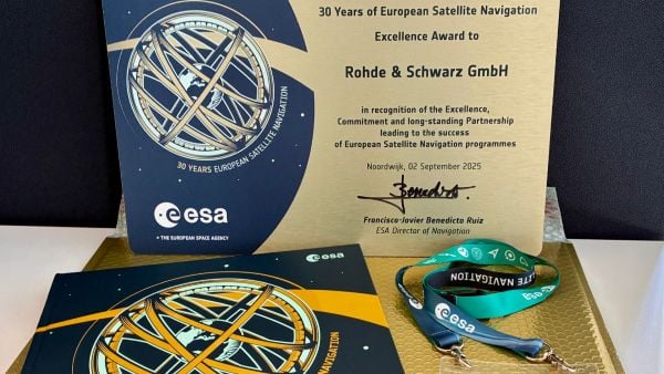
The European Space Agency (ESA) marked 30 years of European satellite navigation with a celebration Sep. 2 at its research and technology center. The event honored key contributors who have shaped the journey of systems like Galileo and EGNOS, which have positioned Europe as a global leader in satellite navigation.
Among the honorees was Rohde & Schwarz, recognized for the excellence, commitment and long-standing partnership leading to the success of European satellite navigation programs over the past three decades.
Javier Benedicto kicks off the celebration of 30 years of satellite navigation. (Photo: ESA)
The event brought together institutional and industrial partners, ESA Member State representatives, and leading figures in satellite navigation. The celebration revisited pivotal milestones in Europe’s satellite navigation history and looked ahead to future innovations.
A highlight of the evening was the award ceremony led by ESA Director of Navigation Javier Benedicto, who, alongside past directors, presented accolades to organizations and partners instrumental in this success story.
Rohde & Schwarz’s recognition underscores their role in advancing European satellite navigation technology. Their contributions have been vital in the development and operational success of Galileo and EGNOS, systems that have revolutionized positioning, navigation, and timing services across Europe and beyond.
The event not only celebrated past achievements but also set the stage for the future of European satellite navigation, with discussions around upcoming initiatives and advancements. For Rohde & Schwarz and other honourees, the evening served as both a celebration of past achievements and a call to continue building a connected, resilient, and sustainable future in space.
“Thirty years of satellite navigation is a testament to shared vision, determination to push technology boundaries, and intense, long-term collaboration,” said Rob Short, director of Business Development at Rohde & Schwarz. “We are honoured to have contributed to this remarkable achievement. Congratulations to everyone who made this milestone possible.”
In universities across the world, theory lays the foundation, but in the field, realism builds true expertise.
For students studying GNSS engineering, textbooks and simulations alone are no longer enough. Tomorrow’s engineers need to use the same applications and work with the same complex environments that professionals face in the real world. This means using tools that generate actual RF signals, not just software abstractions — tools that recreate urban canyons, interference, jamming, spoofing and satellite dynamics with precision.
Safran has established the Minerva Academic Partnership Program, an initiative that brings its Skydel GNSS Simulation Engine to qualified educational institutions worldwide.
A Modern, Software-Defined Approach to GNSS Simulation
At the heart of this initiative is the Skydel simulation engine, a software-defined GNSS simulator. Built to leverage commercially available off-the-shelf (COTS) hardware, Skydel eliminates the need for proprietary hardware. It delivers the full spectrum of satellite constellations — as well as LEO ones — and frequency bands. By integrating Skydel in their projects, researchers now have the tools to pursue ambitious ideas with confidence, such as:
■ Designing and testing custom signals or constellations not yet in existence
■ Simulating real-world scenarios that can include both environmental and man-made interference
■ Integrating and testing additional sensors and platforms through open-source plug-ins and hardware-in-the-loop setups
■ Conducting rigorous resiliency testing against jamming and spoofing in a controlled, repeatable environment without real-world risk
■ Building their own simulator with existing hardware components around Skydel
Empowering the Next Generation of PNT Innovators
Through the Minerva program, Safran provides full-feature Skydel licenses for faculty and student use, creating an environment where learning and innovation thrive. This initiative not only eliminates the barrier to entry but also fosters collaboration between academia and industry –— fueling a new wave of GNSS advancements.
A Global Initiative
Today, Minerva includes more than 80 member institutions and boasts a growing portfolio of peer-reviewed publications and conference presentations.
“This momentum highlights the real-world impact of the program and its role in driving local research excellence and fostering a vibrant, collaborative international GNSS community,” said Pierre-Marie Leveel, program director of PNT simulation at Safran Electronics & Defense. “Safran Electronics & Defense’s Minerva program is more than just a software — it’s a mission to democratize GNSS simulation and nurture the next generation of PNT researchers. As innovation becomes more critical to national sovereignty, transportation, and space exploration, empowering students and researchers has never been more vital.”
Elevating GNSS Simulation
The evolution of Safran Electronics & Defense’s GNSS simulators — across both software and hardware — has been shaped by the growing demands of users and the broader market.
“The demand for multi-vehicle and multi-antenna scenarios has never been higher, and the same can be said for interference simulation,” said Pierre-Marie Le Veel, program director of PNT Simulation at Safran Electronics & Defense.
To address these challenges, Safran’s GSG-7 and GSG-8 Gen2 simulators are engineered to handle a range of applications, from basic to advanced GNSS jamming and spoofing resiliency testing.
The GSG-7 simulator is designed for location-aware applications and systems that depend on navigation or timing. With high-end performance — featuring a 1,000 Hz simulation iteration rate, high dynamics, real-time synchronization, and all-in-view satellite signal simulation — the GSG-7 is well-suited for development and integration projects that demand high performance and extensive constellation licensing. It supports multi-constellation and multi-frequency GNSS simulations and can be configured to operate with all current and upcoming GNSS signals.
Meanwhile, the GSG-8 Gen2 is the latest iteration of Safran’s GSG-8 model, offering flexible simulation capabilities for any device that relies on GNSS signals. Built on Safran’s Skydel-based simulation platform, the GSG-8 Gen2 helps users model scenarios.
Powered by high-end GPUs, the GSG-8 Gen2 offers reliable and precise GNSS signal testing. It can simulate thousands of signals, run multiple instances at once, and introduce jamming and spoofing to evaluate system resilience. The turnkey system features a redesigned chassis for greater connectivity, including six front-facing, high-quality RF outputs, a combined output covering the full GNSS bandwidth, and the same high-end simulation iteration rate as the GSG-7. This allows users to quickly get up and running with complex simulation requirements.
“The market is also demanding realism,” Le Veel said.
All Safran simulators are powered by the Skydel Simulation Engine, which is updated quarterly. Each release introduces new features, signals, and enhancements, enabling more authentic simulations and offering the flexibility to create virtually any GNSS testing scenario.
Staying Ahead of Market Changes and Signal Threats
The recent increase in signal interference threats has driven the demand for enhanced positioning, navigation and timing (PNT) resilience, leading to the broader use of both conducted and over-the-air (OTA) testing. The anticipated deregulation of controlled reception pattern antenna (CRPA) technology also is expected to open the door for civilian markets to perform testing.
“Throughout the past few years, Safran Electronics & Defense has massively revamped our approach to the Wavefront platform and now offers the GSG-Wavefront for those testing CRPA antennas against jamming and spoofing threats,” Veel said.
The ability to safeguard GNSS networks from jamming and spoofing attacks has never been more vital. Achieving this level of resilience calls for a GNSS simulator that can generate dedicated RF signals for evaluating the effectiveness of CRPA architectures.
Safran’s GSG-Wavefront, featuring a shared local oscillator (LO) design, stands out as a field-proven, off-the-shelf solution for CRPA receiver testing. It has a customizable platform that offers upgradable options powered by Skydel — the company’s GNSS simulation engine.
Le Veel added, “We are working hard to keep up with demand in both the defense and civilian markets.”
In addition, Le Veel noted that Safran’s GSG-Anechoic is attracting attention from users who work with anechoic chambers, thanks to its multiple, independent RF outputs, automatic antenna mapping, and built-in calibration features for delay and power loss.
Safran Electronics & Defense supports a wide array of users in both the civilian and defense sectors, spanning aerospace, critical infrastructure and transportation. In recent years, however, the company has seen its fastest growth in the New Space market. Safran’s simulators are used in a range of cutting-edge applications, including satellite navigation, low-Earth orbit (LEO) constellations, and rocket launch and landing systems.
“We are proud that the flexible tools and features we have included in Skydel are being used in these incredibly robust applications,” La Veel said.
A challenge for most GNSS simulation suppliers is ensuring compatibility and coherence with a wide range of GNSS receivers. La Veel shared that Safran Electronics & Defense is in a unique position, as it also designs and manufactures its own receivers, such as the newly released Skylight.
“Additional challenges can arise when developing new signals or constellations, such as the newest LEO ones, said La Veel. “Our close partnerships with both Xona Space Systems and TrustPoint have allowed us to overcome these challenges.”
A single GSG-8 Gen2 simulator from Safran Electronics & Defense can generate more than 2,000 signals without the need for additional hardware. This capability is essential when modeling legacy signals, multipath effects, jamming and spoofing scenarios, or even LEO-constellations.
Safran simulators support all legacy signals, including GPS, Galileo, BeiDou, GLONASS, NavIC, QZSS and SBAS, across all bands and security features such as M-code, PRS and Galileo OSNMA. The systems also offer compatibility with emerging LEO constellations, including Xona’s PULSAR X1 and X5, as well as TrustPoint. Custom Signals and Custom Constellation features offer users the flexibility to create entirely new signals and satellite constellations, or to modify existing configurations.
“It is de rigueur these days for companies to claim or incorporate AI into their solutions. In addition to using AI for tropospheric modeling based on real-world data, Safran Electronics & Defense has also taken a different approach to using AI in GNSS simulation,” Le Veel said.
He added that the company’s upcoming demonstration at ION GNSS+ 2025 will reveal Skydel AI, a new tool designed to make scenario creation and parameter setting as simple as writing an email. “The amount of people who can easily now test their prototypes, products or systems will dramatically increase as the steep curve to learn GNSS simulation is flattened.”