At the 2014 Esri User Conference, Altus Positioning Systems is unveiling a new GNSS RTK receiver designed and developed specifically for the Esri user community.
According to Altus CEO Neil Vancans, the new Altus APS-NR2 provides a new combination of performance and features that make it ideal for Esri users:
Light weight – At 1.5 lbs., the APS-NR2 weighs the same as a dozen glazed doughnuts.
Dual-cellular antennae – With automatic switchover, users will minimize downtime due to signal loss.
Unlimited flexibility – It works on virtually all RTK networks.
Built-in Wi-Fi – Users can configure and monitor the unit and stream data directly to their own tablets.
Supercharged – It runs all day on hot-swappable batteries and recharges from any USB port.
Esri Compatible – It communicates seamlessly with Esri cloud-based platforms.
Open architecture – Users can choose their own data collector software or interface directly with Esri ArcGIS Online.
“It all adds up to the world’s most versatile RTK rover that provides more productivity and less downtime in the field,” said Vancans. “The APS-NR2 raises the bar and sets a new standard for the state-of-the-art in high-precision surveying and geolocation, leveraging the power and convenience of mobile tablet platforms.”
The APS-NR2 will be commercially available by September, according to Vancans.
In addition to the APS-NR2, Altus will show the APS GeoPod, a compact GNSS module that adds high-precision RTK positioning to any USB-compatible tablet PC. “This unique product gives users the convenience of adding RTK precision to any on-board application on their own mobile devices,” said Vancans.
Altus is showcasing the APS-NR2 and APS GeoPod, along with the full range of Altus products, in Booth 1218 at the 2014 Esri Users Conference, July 14-18, in the San Diego Convention Center.
Like it or not, as a person who works with geospatial data, UAS (unmanned aerial systems such as drones and UAVs) are in your future. The upside of said technology for “quick and dirty” mapping is undeniable.
GNSS plays a key role with UAS, just like it plays a key role in classical photogrammetry. In fact, UAS may even push GNSS technology into areas where it hasn’t gone. For example, L1 RTK. I wrote about L1 RTK technology several years ago, and while several products attempted to exploit it, L1 RTK never was adopted in any significant numbers, primarily due to the short baseline, clear sky, and longer initialization requirements. However, UAS may change that because, by their nature, they work with short baselines, clear sky environments and require some setup time, at least enough for L1 RTK initialization.
However, before we get ahead of ourselves, the regulatory machine (the Federal Aviation Administration) must publish regulations that provide guidelines on the use of UAS for commercial operations. In June, amidst its recent enforcement actions, the FAA issued its first commercial authorization for mapping UAS over land in the U.S. The FAA issued a Certificate of Waiver or Authorization (CoA) to BP to conduct aerial surveys in Prudhoe Bay, Alaska. According to the FAA, the first flights took place on June 8 and used a AeroEnvironment 13.5 lb. Puma AE fixed-wing UAS with a nine-foot wingspan.
According to a Wall Street Journal article, AeroEnvironment spokesman Steve Gitlin said it took about a year and considerable financial investment to win FAA approval for the BP project. Curt Smith, a director in BP’s technology office, said that manned aircraft are sometimes less expensive per flight than the AeroVironment devices, but that the drones will gather far more data, enabling BP to operate “more effectively, more safely, and at a lower cost.”
The FAA announced that last summer that it issued restricted category type certificates to the Puma and Insitu’s Scan Eagle, another small UAS. The certificates were limited to aerial surveillance only over Arctic waters. The FAA recently modified the data sheet of the Puma’s restricted category type certificate to allow operations over land after AeroVironment showed that the Puma could perform such flights safely.
Texas A&M University Becomes Fourth Operational UAS Test Site
In further UAS news, the FAA announced on June 20 that Texas A&M University – Corpus Christi became the fourth of six UAS test sites to become operational. The FAA issued a CoA for the university to use an 85 lb AAAI RS-16 UAS with a ~13-foot wingspan. The other five UAS test sites are Griffiss (NY) International Airport, North Dakota Department of Commerce, State of Nevada, University of Alaska, and Virginia Polytechnic Institute and State University.
American Aerospace RS-16 UAS. 12’11” Wingspan. 85 lbs.
The FAA UAS Legal Stuff
Despite its setback when an NTSB administrative law judge ruled against the FAA in March 2013, the FAA sternly maintains its position that commercial operations of UAS in the U.S. are strictly prohibited without a CoA. In fact, just this week (June 23), the FAA issued a press release about a Federal Register Notice the FAA published of its interpretation of UAS rules for model aircraft in the FAA Modernization and Reform Act of 2012. In the Act, the Sec. 336 Special Rule for Model Aircraft reads:
SEC. 336. SPECIAL RULE FOR MODEL AIRCRAFT
(a) IN GENERAL.—Notwithstanding any other provision of law relating to the incorporation of unmanned aircraft systems into Federal Aviation Administration plans and policies, including this subtitle, the Administrator of the Federal Aviation Administration may not promulgate any rule or regulation regarding a model aircraft, or an aircraft being developed as a model aircraft, if—
(1) the aircraft is flown strictly for hobby or recreational use;
(2) the aircraft is operated in accordance with a community-based set of safety guidelines and within the programming of a nationwide community-based organization;
(3) the aircraft is limited to not more than 55 pounds unless otherwise certified through a design, construction, inspection, flight test, and operational safety program administered by a community-based organization;
(4) the aircraft is operated in a manner that does not interfere with and gives way to any manned aircraft; and
(5) when flown within 5 miles of an airport, the operator of the aircraft provides the airport operator and the airport air traffic control tower (when an air traffic facility is located at the airport) with prior notice of the operation (model aircraft operators flying from a permanent location within 5 miles of an airport should establish a mutually-agreed upon operating procedure with the airport operator and the airport air traffic control tower (when an air traffic facility is located at the airport)).
(b) STATUTORY CONSTRUCTION.—Nothing in this section shall be construed to limit the authority of the Administrator to pursue enforcement action against persons operating model aircraft who endanger the safety of the national airspace system.
(c) MODEL AIRCRAFT DEFINED.—In this section, the term ‘‘model aircraft’’ means an unmanned aircraft that is—
(1) capable of sustained flight in the atmosphere;
(2) flown within visual line of sight of the person operating
(3) the aircraft; and
(4) flown for hobby or recreational purposes.
You can read more (lots more) about the FAA’s interpretation of the Act here. You can submit a comment on the FAA’s interpretation of the Act here. The comment period ends July 25.
More FAA UAS Legal Stuff
On June 25, the FAA issued a press release announcing that seven aerial photo and video production companies requested regulatory exemptions from the FAA to operate UAS before the FAA UAS rule-making is finalized. According to the FAA, “the Motion Picture Association of America facilitated the exemption requests on behalf of their membership. The firms that filed the petitions are all independent aerial cinematography professionals who collectively developed the exemption requests as a requirement to satisfy the safety and public interest concerns of the FAA, MPAA, and the public at large.”
From the FAA press release, “The FAA published a brief summary of the petition from Astraeus Aerial in the Federal Register. The agency opted to ask for comments only on the Astraeus petition because that company’s request came in first, and the petitions from the other six companies ask for identical exemptions.”
Interestingly enough, the FAA is soliciting public comment before it makes a ruling on the MPAA request, clearly highlighting the tremendous pressure the FAA is under to integrate commercial use of UAS in the U.S.
More Commercial Use of UAS Despite what the FAA Says
The NTSB ruling against the FAA fueled the commercial UAS fire and certainly gave commercial UAS operators, operating illegally according to the FAA, more confidence that the FAA may not pursue them. That might be the case in an incident publicized last week in Seattle, Washington, where a woman called police after she saw a UAS buzzing around outside of her apartment building, believing it was spying on her 26th-floor apartment. The Portland, Oregon-based UAS operator, Skyris Imaging, was interviewed by Portland’s KATU news.
“It was not our intent to view anything other than the views from a 20-story office building that will be built across the street,” said Skyris’s Joe Vaughn. Vaughn told KATU that a Seattle-based developer hired Vaughn’s company to use one of his drones equipped with cameras to take photos of the view for a new 20-story building.
Vaughn told KATU that his company has a fleet of six drones he says he responsibly flies. He told KATU that his company has strict guidelines to never fly for a third party, over crowds, above 400 feet, or beyond visual range. Click below to view the KATU interview.
Live Webinar at the Esri International User Conference
In a GPS World first, we’ll be producing a live webinar from the Esri International User Conference on Thursday, July 17, @ 10 a.m. Pacific Time in the exhibit hall at the San Diego Convention Center. Of course, the webinar will be focused on one of the hottest topics: high-precision mobile GIS. It will cover high-precision GNSS on mobile devices, from iPads to Android tablets to smartphones.
Tune in or join us live from the exhibit hall floor! Register here.
Juniper Systems and Futura Systems have partnered to provide enterprise utility GIS solutions for the electric and utilities industries. This August, Futura Systems will be launching at its user conference a new pole-staking application called GPSStaker.
Staking, or line design, is performed when new locations need to be added to an existing electric line. It involves mapping a new utility pole run, ensuring that the distance between each pole is up to code and geolocated, and then recording the GPS coordinates of where each pole should be placed. GPSStaker was optimized for Juniper Systems’ Archer 2 rugged handheld, and works with Esri ArcMap.
Using GPSStaker, stakers — or field engineers — can GPS-stake a job on the Archer 2 using ArcPad 10. The data is then automatically synced back into a main database.
“The people in the field want lighter hardware and more efficient staking processes,” said Doug Malinowski, CIO of Futura Systems. “With Futura GPSStaker and the Archer 2, we’ve designed a promising solution that combines the accuracy they need with the design quality they want.”
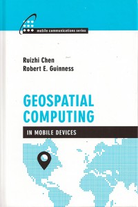
A new text and reference book, Geospatial Computing in Mobile Devices, has been published by Artech House. Recent developments in smartphones enable them to meet many of the demanding requirements for geospatial computing, in terms of computation power, data storage capacity, and memory space. This book, written by Ruizhi Chen and Robert E. Guinness, addresses and instructs in geospatial data acquisition, processing, visualization, context detection, and context intelligence.
Chapters of the 209-page book include:
Fundamentals of Mobile Positioning
GNSS, Wireless, and Hybrid Positioning in Mobile Devices (three separate chapters)
Mobile GIS and LBSs (two separate chapters)
Context Awareness and Reasoning (two chapters), and
I’ve written this many, many times in the past eight years that I’ve written for GPS World magazine, but I have to write it again — this is an exciting time for GNSS!
For me, high-precision GNSS is particularly exciting. I’ve been traveling like crazy, and involved in a number of really fun projects that incorporate high-precision GNSS. Of course, on these various projects I usually incorporate many types of technologies that support GNSS, such as computing, communications, power, and mechanical.
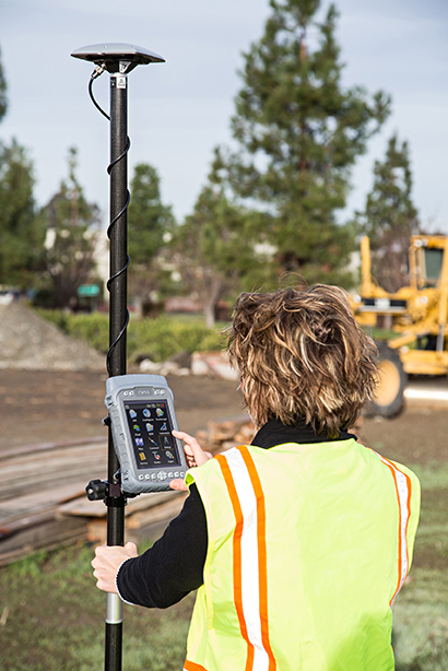
Along those lines, I find myself more and more frequently setting up custom RTK bases for companies because they’re getting cheaper and cheaper, regardless of the fact that there are an increasing number of publicly available real-time kinematic (RTK) base stations. Setting one up doesn’t just involve plugging power into a RTK base receiver and hitting the on/off switch. As I mentioned above, setting up an RTK base involves several different types of technologies. Sometimes, I set up a desktop computer next to the RTK base to act as a server to manage the RTK GNSS base and communications (both network and RTK communications) equipment.
In your mind, when you think of a desktop computer, you probably envision something that occupies 2-3 square feet (~one square meter) of desktop space, along with a keyboard and monitor. So, a consideration when deploying an RTK base is finding desk space somewhere in the user’s office to accommodate the desktop PC and other equipment.
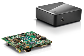
Recently, I took a different approach. I found (actually, my client found) an incredibly small computer to be our server. Just as high-precision GNSS receivers are getting smaller and smaller, so are computers. The Intel Mini-PC measures 4 inches x 4 inches (10.16 x 10.16 centimeters) and has no hard disk. It uses solid-state drive (SSD) memory for storage. SSD technology is still somewhat expensive ($1+ per gigabyte), but it is small compared to a classical disk drive, and doesn’t have any moving parts. Furthermore, the Mini-PC has ethernet ports: when we connect a network cable to it, we could access the Mini-PC via Remote Desktop. That meant we didn’t need a keyboard or monitor. The Mini-PC had all the power we needed, and we could load any sort of control software on it because it runs the standard Windows 7 (or 8) operating system. Last but not least, the Mini-PC costs only $149. However, you need to add memory, SSD, and so on, so the real cost is ~$400 depending on your configuration. While not cheaper than similarly performing “boxes” available, it’s certainly one of the smallest.
Intel Mini-PC Measuring 4″ x 4″
In fact, it’s so small that we stuffed it inside a 14” x 12” electronics enclosure box along with the RTK GNSS base and other network equipment, and hung it out of sight on a closet wall. No desktop space required. Without stretching your mind much, you can see where desktop computing is headed; very small and inexpensive enough to be dedicated to specific tasks. Think about this and then consider the Internet of Things concept. It’s very exciting.
More RTK on Mobile Devices
Later this week I’ll be experimenting with RTK on mobile devices with the CRTN (California Real Time Network), a collection of 330 RTK bases located throughout California. I’ll be using a Panasonic ToughPad running ArcGIS Mobile (and maybe ArcPad) and an iPad using a cloud-based mapping service. The latter is particularly interesting because there are lots of cloud-based GIS data collection apps on the market and under development. Specifically, there’s a lot of subscription-based, cloud-based software. The challenge is that they are even less geodesy-intelligent than the “professional grade” GIS data collection software on the market. In other words, they read coordinates (NMEA format) from GNSS receivers and feed them directly into their app. No datum transformations are provided, neither horizontal nor vertical. That’s going to be a problem.
FCC Levies Record Fine Against Chinese Supplier of GPS and Mobile Phone Jammers
The Federal Communications Commission (FCC) announced that it plans to issue the largest fine in its history against C.T.S. Technology Co., Limited, a Chinese electronics manufacturer and online retailer, for allegedly marketing 285 models of signal jamming devices to U.S. consumers for more than two years. The FCC plans to levy a $34.9 million fine against CTS. The FCC reported that CTS sold 10 high-powered signal jammers to undercover FCC personnel.
The FCC is asking people to report the sale or use of an illegal jammer by contacting the FCC Enforcement Bureau through the FCC online complaint portal, or by calling 1-888-CALL-FCC (or 1-888-225-5322). To voluntarily relinquish a signal jammer, e-mail [email protected]. Additional information, including the FCC Consumer Alert on the jamming prohibitions and the FCC Enforcement Advisory to retailers regarding the marketing of illegal signal jammers, is available at www.fcc.gov/jammers.
You can view the FCC enforcement action against C.T.S. here.
Satellite Launch Pads are Warming Up
Two GPS Block IIF satellites, one launched in February and one launched in May, were set healthy in the past three weeks, making a total of six IIF GPS satellites in orbit broadcasting on three civil frequencies; L1, L2C, L5.
On July 31, the seventh GPS IIF satellite is scheduled for launch, followed by an October 2014 scheduled launch of the eighth GPS IIF satellite.
On June 14, Russia launched a GLONASS-M satellite. It has not been set healthy yet. There are a total of 24 healthy GLONASS satellites in orbit. You can check the current status of GLONASS satellites here.
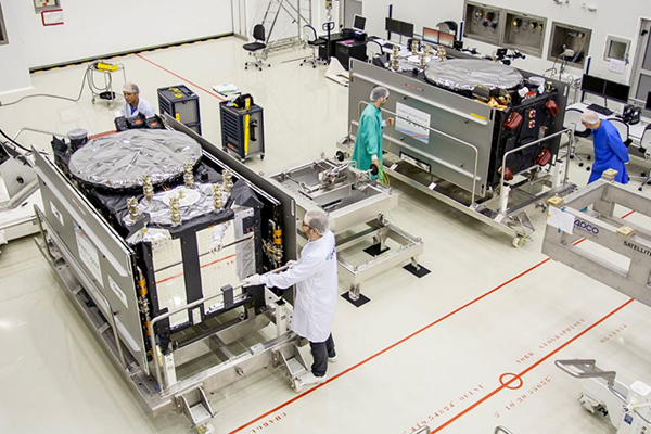
On August 22, Europe is scheduled to launch the first two Galileo FOC (Full Operational Capability) satellites to add to the four test satellites in orbit that will be integrated into the final operational constellation. A second pair of Galileo satellites is scheduled for launch in November 2014. These are projected dates and subject to slippage.
Galileo Satellites in the Clean Room
Live Webinar from the Esri International User Conference on July 17
In a GPS World first, we’ll be producing a live Webinar from the Esri International User Conference next month on Thursday, July 17 @ 10 am Pacific Time in the exhibit hall at the San Diego Convention Center. Of course, the webinar will be focus on one of the hottest topics, high-precision GNSS on mobile devices; from iPads to Android tablets to smartphones.
Tune in or join us live from the exhibit hall floor! Register here.
Members of EuroGeographics are creating a European platform for networking, sharing best practices, and exchanging expertise on GNSS positioning.
Plans for the new Positioning Knowledge Exchange Network (KEN) were revealed at the association’s recent Extraordinary General Assembly following a proposal by the Head Office for Geodesy and Cartography, Poland. Its focus will include:
maintaining a network of experts in satellite positioning and navigation
following the development of relevant technologies and practices
working on the most effective utilization of Galileo services, and
developing common standards, policies and guidelines for best practice.
Now EuroGeographics members will work to agree on roles and joint actions through a cooperation agreement with the European Position Determination System (EUPOS), the Reference Frame Sub Committee for Europe (Euref), and the Council of European Geodetic Surveyors (CLGE). The new Positioning KEN will incorporate experts from all four organizations and will also invite other key players to participate.
“This is a really exciting addition to our range of benefits for members,” said EuroGeographics Executive Director and Secretary General Dave Lovell OBE. “It demonstrates how they are driving the association’s development to ensure its activities continue to meet their needs by reflecting emerging trends and the relevant interests of the European Institutions. We look forward to strengthening our relationships with EUPOS, Euref and CLGE as we work together to create the uniform GNSS service for Europe.”
EuroGeographics KENs provide an open forum for members and invited experts. Each focuses on an area of particular interest for national mapping, land registry and cadastral authorities. These include Business Interoperability, Quality and Emergency Mapping.
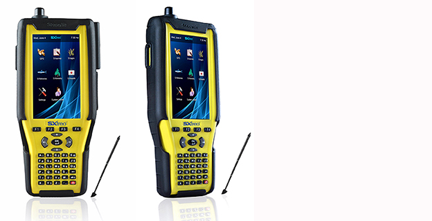
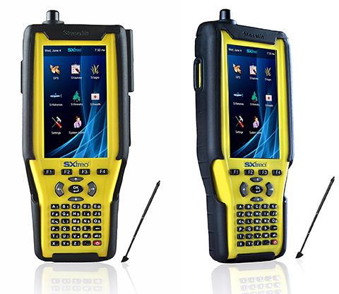
Stesalit today announced the availability of the SXtreo range of rugged GPS handhelds for survey, industrial use, and field work under extreme conditions such as agriculture, forestry, roads, security and construction.
The SXtreo series of mobile devices are rated IP-68, meaning they are waterproof, dust proof, shockproof, and are coupled with built-in mobile GIS applications. Long battery life allows GPS data collection for a full work day, without the need for recharging. The GNSS devices come with full-size USB port for connecting devices.
Stesalit is based in India, and the SXtreo gives that country an affordable option to take geotagged photos and conduct waypoint surveys. The design and conceptualization of SXtreo is a result of the in-house R&D effort of Stesalit. The road towards the birth of SXtreo is presented in the video:
The GAGAN-enabled SXtreo GN series of rugged GNSS field computers and PDAs comes with a full keypad and large five-inch sunlight-readable screen for field data entry in large forms. These models are designed for GPS data collection and asset management, socioeconomic surveys, mapping, agriculture, logistics, forestry, public transportation, construction and security.
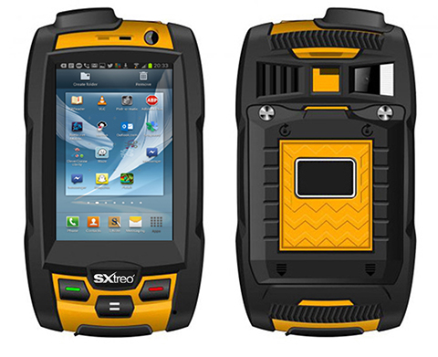
The SXtreo WP 60 and WP61 devices have all the features of a smartphone.
The SXtreo WP 61 rugged smartphone.
SXtreo handheld’s Android and embedded Linux-based open-source secured operating systems are compatible with a range of sector-specific applications designed by Stesalit.
SXgeo is specially designed for waypoint, routes, and track surveys. The added advantage from the similar existing applications is that one can capture geotagged photos and transfer the survey data through GPRS.
SXsurvey is a complete suite for comprehensive survey management. With the features of SXgeo, one can also create large forms dynamically in the devices for survey data collection.
SXfield is specifically built for the field workers and employees working away from office like road construction, oil, gas and other utility services, logistics and distribution chains, FMCG, consumer and white good companies with large sales networks, operations and maintenance organizations with large service networks, and security organizations including police.
The integrated application SXagro is a geospatial agriculture decision-support system in use by agriculture universities and state agriculture departments.
In addition, the SXtreo range of IP68 rugged smartphones is compatible with most of the off-the-shelf mobile software applications.
Trimble’s CenterPoint RTX correction service is now available for heavy civil construction applications. Available worldwide as a subscription service, CenterPoint RTX offers construction companies a flexible and easy-to-deploy option for conducting pre-bid reconnaissance and initial site measurements without using a traditional base station, the company said.
“Offering CenterPoint RTX for heavy construction applications further extends the Trimble Connected Site strategy to simplify site operations. CenterPoint RTX will make it easier to collect high-quality data in the early phases of site establishment, improving material estimates and job bids,” said Roz Buick, vice president and general manager of Trimble’s Heavy Civil Construction Division. “With more accurate material estimates and bids, contractors can incur fewer change orders and avoid unnecessary costs and delays.”
Based on Trimble RTX technology, CenterPoint RTX is a satellite-delivered positioning source that streams GNSS corrections to rover systems with the Trimble SPS985 GNSS Smart Antenna, SPS985L GNSS Smart Antenna, or SPS855 GNSS Modular Receiver. There is no need to have an additional data plan or additional hardware.
The CenterPoint RTX service is a correction source for construction sites in the pre-bid and site planning phases. Construction surveyors and estimating teams can use CenterPoint RTX to perform topographic surveys, estimate quantities, and conduct site planning quickly and easily, before a base station is needed on site for machine control and other high-accuracy applications.
“Trimble strives to provide advanced GNSS correction services that fit our customer’s specific needs and applications,” said Patricia Boothe, general manager of Trimble’s Positioning Services Division. “For the heavy civil construction industry, this means a job crew can arrive on a new construction site and begin conducting site measurements and collecting data right away. CenterPoint RTX also makes it easier to work on multiple construction sites with the same rover system. There is no need to pair the rover with an existing base station at each individual site.”
Trimble CenterPoint RTX is a subscription service available through Trimble Positioning Services in North America, South America, most of Europe, Russia and the Commonwealth of Independent States (CIS), Africa, Asia, and Australasia.
Trimble has introduced a new version of its office software suite used by surveyors and geospatial professionals for processing and analyzing geospatial data. Trimble Business Center Version 3.21 introduces new coordinate reference systems and a specialized Advanced Drafting module, which enables faster project turnaround and better decision making.
The optional Advanced Drafting module adds highly customizable templates and simplified selection tools, which are designed to reduce the time required to generate high-quality deliverables, such as geospatial maps and corridor cross-sections. Now, professionals working on road, pipeline, and railway projects can achieve efficiency gains through the software’s new automated cross-section plotting functionality.
Also included in the new module is the ability to create 3D PDFs so that team members and clients can collaborate from any computer or mobile device using Adobe Reader software.
“Trimble Business Center is the enterprise solution for surveyors and geospatial professionals to produce high-quality deliverables,” said Alain Samaha, business area director of GIS and Software for Trimble’s Geospatial Division. “These new capabilities demonstrate the continued evolution of our software portfolio to provide customers with an end-to-end solution to fulfill their client’s high-end requirements in the most efficient way.”
Sokkia has added the GHX2 network rover to its GNSS family of surveying products in the North American market. The GHX2 is designed to pair with the Sokkia SA300 external antenna to provide enhanced positioning accuracy and RTK performance in demanding environments.
“The power of a built-in survey and mapping grade GNSS receiver makes the GHX2 an excellent choice,” said Brice Walker, Sokkia vice president of survey sales. When combined with the Sokkia SA300 antenna, the system is a perfectly balanced and lightweight solution for surveying professionals.”
Features include a large 5.7-inch, sunlight readable touchscreen, waterproof housing, a built-in 3.2 MP camera with 4 GB of flash storage, and Bluetooth and Wi-Fi connectivity.
The system is compatible with MAGNET Field and Sokkia Receiver Utility (SRU) software.
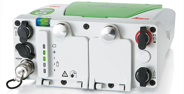
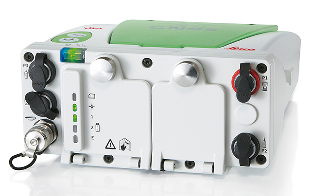
The Leica Viva GNSS Unlimited Series, available in August, will allow customers to make a safe investment with future-proof GNSS receivers and smart antennas, Leica Geosystems said in announcing the new series. With a flexible design, the Viva GNSS sensors can be upgraded for maximum performance whenever needed.
The Leica Viva GNSS range fully supports the Chinese BeiDou navigation system. It can even provide BeiDou-only and GLONASS-only high-precision positioning. The unlimited series includes a future upgrade to a GNSS board with more than 500 channels and will serve users’ needs beyond 2020, the company said. Outages of real-time kinematic (RTK) communication links are bridged for up to 10 minutes with SmartLink to increase centimeter position availability in areas where RTK communications links are unstable.
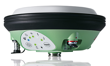
Leica Viva GS15
The Leica Viva GNSS Unlimited Series can be upgraded to the full range of GNSS signals. The sensors’ future-proof design is equipped for GNSS modernization, providing users with confidence in their investment. The series embraces the future-proof concept by including an upgrade to a GNSS board with more than 500 channels. To fully guarantee future proof GNSS, board exchanges are inevitable because any likely modifications in GNSS signals require a new GNSS ASIC (Application Specific Integrated Circuit).
Leica SmartTrack technology guarantees accurate signal tracking, while SmartCheck technology evaluates and verifies RTK measurements to ensure reliable results. Both SmartTrack and SmartCheck technologies have been extended to support the BeiDou GNSS. BeiDou reached full operational regional capability in 2012 and has a total of 14 satellites. Leica Viva GNSS also supports features like BeiDou-only and GLONASS-only positioning to accommodate governmental regulations.
In addition, Leica Geosystems now offers SmartLink, a correction service delivered via satellite for uninterrupted centimeter positioning in areas where RTK communication links are unstable.
Leica Viva GS14
All Leica Viva GNSS products exceed the toughest environmental specifications, going beyond industrial standards such as IP68. This ensures flawless performance even in the most challenging environments. Applications for the range include construction and field surveying, mining, seismic work in dense forest, desert or mountains, as well as demanding work in extreme heat at 65°C (149 °F) or at extreme latitudes at -30°C (-22 °F). Premium precision and attention to detail ensure that the Leica Viva GNSS products can be trusted throughout the complete product lifetime.
Leica Viva offers a complete range of unlimited GNSS and TPS solutions made with Swiss precision, combining the highest accuracy with maximum versatility and optimized data flow. Leica Viva solutions include Active Customer Care (ACC) with an expansive organization of knowledgeable professionals to provide valuable support, training and service whenever needed. Combined with innovative services such as online support in the field with Leica Active Assist and an instant data exchange between field and office with Leica Exchange, Leica Viva enables continuous productivity.
Webinar on Multi-GNSS OEM
Thursday, June 5 10 a.m. PT / 1 p.m. ET / 5 p.m. GMT
GPS World’s upcoming webinar features an expert panel with informed viewpoints from GNSS high-precision and mass-market manufacturing, signal simulation, and alternative PNT providers. Registration is free.
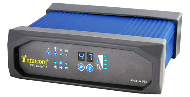
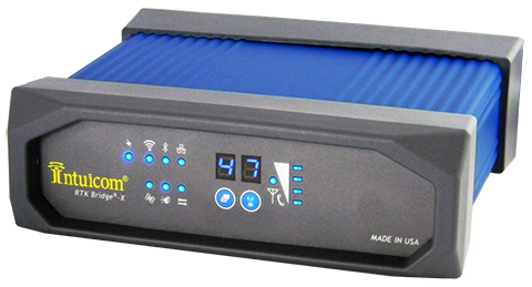
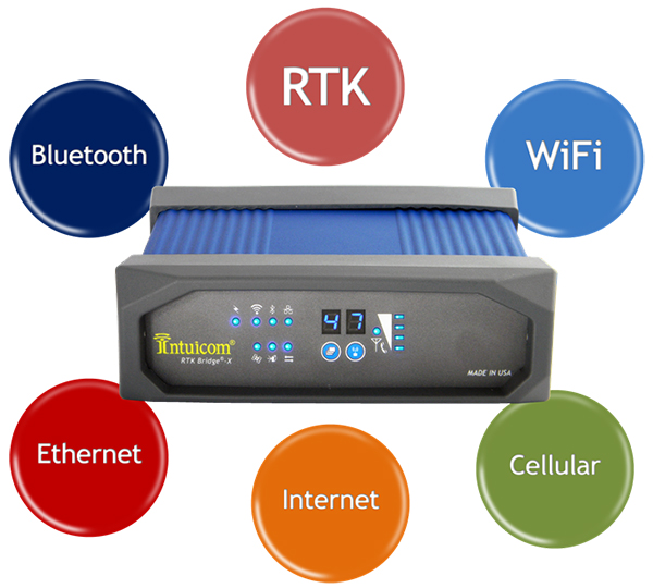
Intuicom, Inc., a wireless data solutions provider for the survey, machine control and precision agriculture industries, has added to its line of RTK Bridge solutions with the Intuicom RTK Bridge-X.
Along with providing reliable access to RTK corrections, the RTK Bridge-X features a Wi-Fi hotspot. Users can connect other Wi-Fi devices such as laptops, tablets and smartphones and access the Internet via the RTK Bridge-X’s cellular connection. Also new with the RTK Bridge-X is cable-free configuration. Configuration can now be accomplished through a wireless connection using any web browser.
Users can then access email, send files, and perform other Internet-based tasks using the connection provided by the RTK Bridge-X. With new Remote Access, the RTK Bridge-X can be reached over the Internet from anywhere.
The RTK Bridge-X also comes with internal GPS. Users can choose between an internal license-free 900-MHz radio, industry-standard UHF radio, or no radio.
Other improvements include a real-time cellular signal strength indicator on the re-designed front panel, as well as an Ethernet port that can be used for configuration or Internet connectivity. A numerical LED display now shows which of the four configurable profiles is active as well as which radio channel is selected. Bluetooth connections are also supported.
Like all Intuicom Bridge Products, The RTK Bridge-X is designed for easy setup and operation and is compatible with all major cellular carriers and equipment manufacturers including Leica Geosystems, Trimble, and others.