Intergeo 2016 host DVW German Society for Geodesy, Geoinformation and Land Management gathered together experts from the worlds of business, public authorities and science to talk about this year’s key topic of the show: the “smart city.” Held in April at Hamburg’s Agency for Geoinformation and Surveying, the event focused on what an intelligent, digital city might look like and what role geoinformation would play as cities and metropolitan regions become “smart.”
Intergeo 2016, the leading international event for the geospatial community, will be held Oct. 11-13 in Hamburg, Germany, and also will focus on smart cities as a multi-faceted issue to shape the future.
During the preview, attendees agreed that cities must, and will, become more intelligent because of the benefits it has to society, Intergeo officials say in a May news release.
“They all agreed that the increasing penetration of digital technologies into cities is not an end in itself.” Intergeo says in the news release. “First and foremost is the common good of society and the advantages that digitalization offers inhabitants. This will ensure that cities can be run on a more intelligent basis and thus become a sustainable living space. The preview participants felt that smart geodata was an essential prerequisite in this regard.”
The host city for Intergeo 2016, Hamburg has been quick to position itself with “Hamburg’s Strategy for the Digital City,” which aims to develop a standardized smart city strategy. Key areas include mobility, energy, business and work, accommodation and city life. The city’s residents also will be involved in the strategy.
The roll-out of intelligent solutions for individual segments of the city is done in dialogue with residents, politicians, administrators, business people and scientists. Taking traffic as an example, smart mobility concepts are designed to improve the flow of traffic so as to minimize the delays caused by congestion while also lowering CO2 emissions, Intergeo says. Measures of a smart city include intelligent transport systems, semi-automated vehicle guidance, sharing concepts, intelligent parking facility management, apps for inhabitant participation and city planning processes that help to avoid traffic in the best-case scenario.
Everyone at the preview agreed that a standardized language must be developed and understood if forward-looking, complex processes such as the development of an intelligent digital city are to be successfully rolled out, according to Intergeo.
Septentrio has introduced its next-generation high-precision Altus APS3G real-time kinematic (RTK) receiver, which brings technology only previously available in scientific receivers into the field for professional surveyors.
The new multi-constellation APS3G addresses major concerns about compatibility with new satellite constellations, as well as interference and jamming, according to Neil Vancans, vice president of Septentrio Americas.
Built on Septentrio’s AsteRx4 engine, the APS3G tracks all-in-view GPS, GLONASS, BeiDou, IRNSS, SBAS, Galileo and QZSS, including E6/L6, and all other signals known to be available in the medium term.
The APS3G incorporates Septentrio’s AIM technology with three notch filters for in-band jamming and chirp jammer resistance, ensuring the highest possible levels of accuracy and resilience under all conditions. This technology is proven in Septentrio’s reference station and scientific products, which are acknowledged as technology leaders and deployed by major research institutions all over the world.
With two hot-swappable batteries, the APS3G provides up to 14 hours of operation without recharging, the longest endurance of any high-precision GNSS receiver in the surveying industry, maximizing uptime in the field.
The APS3G provides optimum GSM signal reception, as well as a built-in advanced UHF receiver for reliable performance on longer baselines, yielding real-time 25 Hz RTK. It also supports TERRASTAR L-band corrections for sub decimeter-level accuracy.
The flexible APS3G receiver can function as either a rover or base station, providing maximum versatility in the field.
“The Altus APS3G with embedded AsteRx4 technology brings what has previously been available only in high-priced scientific GNSS receivers to the workplace of the average surveyor,” said Vancans.
“With 544 channels capable of tracking all known and foreseen satellite signals and bands, the all-in-one unit is future proof, and Septentrio’s open architecture makes the APS3G compatible with most other hardware and software solutions, driving down the lifetime cost of ownership. In addition, with its extremely low power consumption, no other survey receiver on the market gives as much battery life, saving time and money on the job.”
CHC has launched its new N72 GNSS series, a high-end sensor designed for GNSS applications including offshore surveys and machine control, national geodetic networks, crustal deformation monitoring and bathymetry
CHC N72 GNSS series.
The N72 GNSS series is designed to offer all necessary technical features, making it one of the most complete and reliable GNSS receivers for scientific and surveying industries professionals.
“To meet the market requirements from geodetic survey and demanding applications such as CORS, on-board machine control and disaster monitoring, CHC research and development has designed one of the most feature-rich GNSS receivers available on the market. The N72 GNSS went through extensive validation and stringent quality process to achieve high performance and reliability,” said George Zhao, CEO of CHC. “This new-generation GNSS sensor reinforces our commitment to provide complete solutions to GNSS professionals.”
N72 features top level specifications:
Embedded battery supporting 15 working hours without external power supply
32GB internal memory integrated and 1TB+ external memory supported
8 threads of logging with circulating storage and FTP push functions
Wi-Fi, LAN, Bluetooth and serial ports for data communications
LCD display and function buttons for direct configuration
CORS station tracks China’s constellation over three frequencies.
Headquarters for the National Bank of Kuwait, a new 300-meter-tall building under construction, combines concrete, steel, glazing and glass-reinforced concrete in a unique shellfish shape. The engineering challenges behind this building led the engineers of Ahmadiah Company, the contractor, to use GNSS technology to install the core wall structure with millimeter accuracy.
They adopted the core wall control survey method developed by Joël van Cranenbroeck during construction projects in Dubai. To guarantee the precise vertical thrust of a tower during construction, complete control must be maintained of the position of each new element erected on top of the existing core walls. Such new elements, and their formwork structures, must be precisely positioned with respect to the main axis of the design reference frame, defined as the vertical positioned in the tower center. This means that the position of the formwork structures at the top of the tower must be continuously measured during erection of the building.
Core walls are constructed bit by bit, one on top of the other. Each core wall element consists of several concrete pours. The placement of the formwork structure on top of existing core walls must be done precisely, determined from the position of previously placed elements. For this purpose, control points (nails in this instance) are set in the top of the concrete. The basic task of the surveyor is to determine the coordinates of these control points and to compute and stake out the position of the formwork structure in a design reference system based on the main axis of the tower. Dual-axis inclinometers, precise leveling observations and vertical laser plummets complete the method, which is based on a sensor fusion approach.
Active Control Points
A small network of three to four GNSS receivers and antennas are installed on top of the formwork to provide control points to total station operators. As the construction stages rise, surveyor sightings of ground-based control points decrease.
An active GNSS control point consists of a 360° reflector with a GNSS antenna screwed on its top. The coordinates obtained by post-processing the GNSS observations are transformed in the local datum and are available for any total-station “free station” calculation operating on the building top.
The technique has proven to be successful in several other projects worldwide. Comparisons with resection on ground control points, when made possible by tower height, indicated differences of less than a few millimeters.
GNSS CORS Station
As GNSS can only deliver such performances in differential mode, this requires setup of a local GNSS base station.
The local GNSS CORS station receiver and a geodetic-grade GNSS antenna were placed near the construction site and connected to an Internet router to provide easy access whenever the data had to be downloaded for post-processing the GNSS receivers placed on top of the building.
To confirm that the GNSS observations by the selected reference receiver match with those of GNSS receivers used in previous similar projects, a zero baseline test was performed by connecting both sets of equipment to the same GNSS antenna. Simultaneously, a temporary GNSS base station was set up using another geodetic receiver.
All the RINEX data collected over an hour was processed using open-source RTK-LIB software. The results showed less than a millimeter variation between the receiver selected for the project and those used on previous projects.
The baseline components between the temporary base station and both receivers showed respectively 1 millimeter in X and Y (WGS-84) and 2 millimeters in Z difference.
BeiDou Role
Up to 11 BeiDou satellites are now visible in the sky over Kuwait. By setting up the selected BeiDou-capable receiver as a local CORS station — processing signals over the three constellation frequencies (B1, B2 and B3) — project operators benefit from additional GNSS signals that aid positioning where obstructions make GNSS use challenging.
The National Bank of Kuwait construction is the first GNSS CORS station tracking Beidou satellite signals deployed in the Middle East area. Surveyors on this job can access remotely via the on-board web server all the information (satellites in view, quality indicators, memory, RINEX files and so on), and can evaluate the impact of new signals and new frequencies within the context of an exceptional architectural project.
Manufacturers
The GNSS M300 Pro from ComNav Technology (Shanghai, China), a multi-purpose GNSS receiver for a range of applications, has 256 channels tracking GPS, GLONASS and BeiDou, with Galileo capability.
Joël Van Cranenbroeck established Creative Geosensing Belgium as an engineering geodesy consultancy company specialized in high-definition positioning, positioning infrastructures (CORS network) and monitoring.
The compact FlexPak6 receiver houses NovAtel’s OEM628 triple-frequency plus L-band GNSS receiver board. It tracks all current and future GNSS constellations, with a highly configurable interface designed to meet current and future positioning and integration needs. The FlexPak6 is a GPS and GLONASS receiver that is also Galileo and Compass ready. Upgradable receiver firmware ensures easy updating to future signals. While multi-constellation tracking provides higher solution availability and reliability, its flexible communication interface broadens deployment options. It provides 100-Hz measurements for high dynamic applications. Signals tracked include L1, L2 and L2C and L5. It also has RT-2, ALIGN, GLIDE, RAIM firmware options.
Single- or dual-antenna receiver with latest algorithms
AsteRx-U dual-antenna receiver.
The AsteRx-U receiver incorporates the latest GNSS tracking and positioning algorithms, such as LOCK+ technology to maintain tracking during heavy vibration machine use and IONO+ technology to assure accuracy in regions of elevated ionospheric activity. Interference mitigation counteracts ambient and deliberate RF interference. The AsteRX-U is built around Septentrio’s latest application-specific integrated circuit (ASIC), the GReCo4, and incorporates built-in jamming detection and countermeasures, multipath rejection and fast acquisition. More than 500 hardware channels track all available constellations (GPS, GLONASS, Galileo, Beidou, IRNSS and QZSS).
For applications requiring both RTK and orientation
The Trimble BD935-INS delivers GNSS and inertial technology in an easy-to-integrate form factor for demanding conditions and applications such as lightweight robotic or unmanned vehicles. It features precision GNSS with an integrated 3D micro-electro-mechanical systems (MEMS) inertial sensor package, triple frequency for both GPS and GLONASS constellation, and dual frequency for BeiDou and Galileo. The compact module augments real-time precise positioning with 3D orientation. Connectivity and configuration allow system integrators and OEMs to add GNSS and attitude to specialized or custom hardware solutions. By integrating inertial sensors onto the GNSS module, users receive more robust performance in challenging environments. The module delivers fast and reliable real-time kinematic (RTK) initialization for 1–2 centimeter positioning. The integrated GNSS-inertial engine delivers high-accuracy GNSS and DGNSS positions in challenging environments such as urban canyons, tunnels and heavy canopy.
With its robust 555-channel engine, the new Leica Viva GS16 receiver is empowered by RTKplus to access all known and current signals while intelligently distinguishing which ones are the optimal combination to lock onto for accurate positioning adapting to any environmental conditions. There is also capacity for future signals, such as the full deployment of BeiDou and the expected progress of Galileo and QZSS. Thanks to SmartLink, the precise point-positioning technology, uninterrupted positioning continues even when local corrections services are unavailable due to obstructions or lack of cellular coverage. When no reference data is available, SmartLink continues to enable fully remote work. On a field tablet or controller, users can interact with immersive 3D models directly in the field, ensuring all data is collected and linked to the office.
SurphSLAM combines the new Surphaser 10 laser scanner and GeoSLAM’s new RealTime SLAM registration software. SurphSLAM can be used for extremely accurate high-resolution 3D mobile mapping without the need for GPS. The integration of technologies allows for the resulting point cloud to be registered and displayed in real time, facilitating the performance and speed of the survey. Surphaser scanners produce high-accuracy data sets with ultra-low noise levels. The combination of speed, low range noise, sub-millimeter accuracy and reduced size of the scanner make it suitable for a versatile mobile mapping system such as SurphSLAM. The custom-designed trolley is lightweight and collapsible.
OGC GeoPackage enables platform-independent data exchange
TerraGo Edge 3.9.3 features full support for OGC GeoPackage, a universal format for sharing maps and geographic data across mobile devices and platforms. TerraGo Edge enables users to import and export OGC GeoPackage as a SQLite database optimized for performance on iOS and Android devices. Release 3.9.3 closes the loop for a complete GeoPackage collaboration workflow by allowing Edge app users to import GeoPackage data from a mobile device, collect location-tagged field data, and roundtrip the information back to the GIS or other enterprise systems of record.
Open-source client extended with full galileo support
BNC on a Mac system for static real-time precise point positioning with Google Maps, such as for early warning of natural hazards.
Version 2.12 of the BKG NTRIP Client (BNC) real-time software for Windows, Linux and Mac now comes with complete command line interface and considerable post-processing functionality. RINEX Version 3 file editing and quality check with full support of Galileo, BeiDou and SBAS — besides GPS and GLONASS — are also among the new features. BNC version 2.12 allows simultaneous multi-station precise point positioning (PPP) for real-time displacement monitoring of entire reference station networks. Comparison of satellite orbit/clock files in SP3 format is another new feature, along with a large set of examples for various applications. BNC software was originally developed bythe Federal Agency for Cartography and Geodesy (BKG) and Czech Technical University.
The Leica GMX910 smart antenna is desgined for static, long-term projects requiring a high number of sensors. It can enable dynamic monitoring with up to 10-Hz data streaming and advanced multi-frequency, multi-constellation tracking. Starting with the basic GPS single-frequency receiver and adding multiple upgradable options, the antenna adapts to a wide range of GNSS monitoring applications, from complex manmade to natural structures. The smallest movements of bridges, dams or high-rise buildings are detected in real-time. The antenna supports multiple GNSS satellite systems and signals, tracking up to 555 channels. An IP67 rating against dust and water, extended temperature ranges and low power consumption enables installation of the device in remote areas and severe conditions.
For disaster monitoring, traffic patrol, security monitoring
The 25-gram HX-CH6601A GNSS helix antenna for UAV and geospatial applications receives GPS L1/L2, GLONASS L1/L2 and BeiDou B1/B2. It offers exceptional pattern control, polarization purity and high efficiency in a compact form factor. The antenna is equipped with a high-quality, durable IP65 sealed radome housing and terminated with a subminiature version A (SMA) connector, which has high gain and wide beam width to ensure the signal-receiving performance of satellites at a low-elevation angle.
The pingRX ADS-B (automatic dependent surveillance – broadcast) receiver requires 1/100th the power of conventional ADS-B receivers. It implements sense-and-avoid capabilities for small drones operating in the National Airspace. pingRX measures 32 x 15 x 3 millimeters, which is a fraction of the size of earlier units. It receives ADS-B information broadcast by other aircraft on two frequencies approved by the U.S. Federal Aviation Administration (978 MHz and 1090 MHz.) This allows the unit to detect commercial aircraft threats within a 100-statute-mile radius in real time.
Available as turn-key sUAS or as standalone gimbal
The U1 is a professional-grade unmanned aerial vehicle for the industrial survey and surveillance markets, as well as for cinematographers. Features include redundant flight control and battery systems, customized downlink with two high-definition (HD) video feeds, stability even at full zoom with a gyro-stabilized gimbal system, and remote camera control.
Car & Driver branded dash cam includes built-in GPS
The dash camera CDC-601 is equipped with built-in GPS and motion detection. Media shortcut keys allow the driver to manage settings and view their recordings. The camera automatically records when the driver starts the engine and shuts down when the ignition turns off. The 1080p high-definition camera has a 120-degree wide-angle lens, loop recording, time stamp and accident detection. An 8-GB card is included, but it can support up to a 32-GB card.
A science ROV being retrieved by an oceanographic research vessel.
The Rovins Nano is a new inertial navigation system for the offshore industry. Based on iXBlue’s fiber-optic gyroscope technology, the Rovins Nano is designed for for remotely operated underwater vehicle (ROV) pilots performing maintenance and construction operations. It offers the stability and accuracy of the inertial position, outputting true north, roll, pitch and rotation rates. It can directly transmit the ROV’s position with extreme accuracy because of its integrated INS algorithm capable of collecting acoustic data, regardless of the depth. Rovins Nano adapts itself to the user with easy configuration, installation and use. The goal is for the pilot to forget the existence of the product when maneuvering. Because of its compactness, lightness and open architecture with all third-party sensors, Rovins Nano is easy to integrate into existing ROVs.
New platform optimzed for transportation departments modernizing aging CORS installations
The Septentrio PolaRx5 GNSS receiver.
A new PolaRx5 Continuously Operating Reference Station (CORS) platform has been optimized for state departments of transportation (DOTs) and other real-time-kinematic (RTK) network operators. The PolaRx5 is powered by Septentrio’s AsteRx4 next-generation multi-frequency engine. It offers 544 hardware channels and supports all major satellite signals including GPS, GLONASS, Galileo and BeiDou, as well as regional satellite systems such as QZSS and IRNSS. Septentrio’s Advanced Interference Mitigation (AIM+) technology enables the PolaRx5 to filter out both intentional and unintentional sources of radio interference, from narrowband signals over high-powered pulsed signals to chirp jammers and Iridium transmitters. In addition, Septentrio’s patented APME+ multipath mitigation technology guarantees superior measurement quality by eliminating short-delay multipath errors without introduction of bias. The PolaRx5 leverages Septentrio’s web interface and built-in Wi-Fi and Bluetooth interfaces to give users complete control and visibility of the receiver. The user interface integrates into existing network management systems. The web browser provides secure access to all receiver settings and status, data storage and firmware upgrades as well as a built-in spectrum analyzer for system monitoring.
The Omata One speedometer displays essential information to cyclists in a classic form. The GPS computer inside the speedometer records with high precision so that cyclists can download their activity data to their preferred training applications or websites. On the outside, Omata One has a legible and mechanical analog movement that shows riders the speed, distance, ascent and time. The product displays only these four core pieces of information so the cyclist can focus on the ride. Omata plans to offer additional GPS speedometers for other sports.
Adds LTE, Wi-Fi and cloud-based diagnostics to older cars
Samsung Connect Auto plugs directly into a car’s OBD II port underneath the steering wheel. It uses real-time alerts to help users improve their driving behavior, including increased fuel efficiency, while offering a Wi-Fi connection for passengers. The connection is kept secure using Samsung KNOX , the company’s mobile security platform. The backbone of Samsung Connect Auto is KNOX security and Tizen OS for interoperability. Developers can leverage Tizen and Samsung’s software development kit (SDK) to further evolve additional services. Samsung also encourages safe driving behavior by using geofencing and driver rating algorithms. In the event of an accident, emergency alerts notify the driver’s contacts, and accident concierge services are provided. A “Find My Car” app also helps in locating a car in real time using LTE and GPS. Samsung Connect Auto will initially be available in the second quarter in the U.S., with AT&T the first wireless provider.
A lot of talk is being made about UAVs these days and how this technology is going to revolutionize many industries, with surveying being one of the biggest users.
I won’t deny the impact this new tool is going to have on our profession (as written in my last column). But I don’t think it will compare to the use of GNSS technology and how it modernized measuring methods for the surveyor.
I’m often asked by young surveyors what I think is the biggest improvement experienced by the surveying profession. Ironically, I asked that same question to my teachers when I was a new survey technician. My mentors will talk of the electronic distance meter, the theodolite or the total station. (Some old timers even told me the best improvement was the gammon reel for their plumb bob or the reel for a steel “chain”!)
While these were good advancements, for me the biggest improvement was the introduction of GPS into surveying, followed by the advancement to real-time network capability. Now, coupled with modern communication methods of radio or cellular transmission to permanent base stations, the GNSS rover has become one of the most valuable tools in the surveyor’s toolbox.
To understand the importance of GNSS technology and its use by the surveying community, first take a look at the history of the profession and method/devices used for measuring. Land surveyors have been measuring boundaries of parcels for centuries, dating back to Egyptian times and workers known as “rope stretchers.” Their use of rope with knots tied at specific intervals was the measuring stick of the time period.
As centuries passed and measuring units were developed, surveyors used these dimensional tools for measuring and describing land parcels. By the time the early settlers of America began traveling westward, surveyors were using a 66-foot-long Gunter’s chain made with 100 links, each almost eight inches long. Over time the links would stretch until the surveyor’s measurements were not accurate for land surveys.
By the early 1900s, tapes made from low-expansion steel became more widely used and much more accurate for surveying. The early 1960s brought new technology with measurement systems using laser light beams with the ability to travel several miles with sufficient accuracy.
A total station.
The electronic distance meter (EDM) allowed the surveyor to cover longer distances in much less time than the conventional method of the steel tape, leading to more productive field time. This technology was further refined to be installed inside of traditional theodolites to create the modern total station instrument — still used today for basic measuring of angles and distance. Almost all surveying projects can be completed using a total station, but the invention of a remotely available measuring device would be a welcome tool in the surveyor’s toolbox.
Enter the 1980s and the adaptation of the military’s satellite measuring system for civilian use. While early users and developers needed a Ph.D. in mathematics to configure its use, GPS measurement revolutionized long-distance measurement for the surveying profession. Static GPS measurement took many hours of data collection and even longer processing time, but with terrific results and with tremendous accuracy.
Further refinements with hardware and software configurations brought more affordable and user-friendly systems that gave surveying community another resource for accurate measurement. While the use of real-time kinematicc (RTK) expanded greatly in the late 1990s and 2000s, the big difference in the past 10+ years has been the introduction of real-time networks and permanent base stations. This advancement helps by eliminating the need for a base receiver and radio with an amplified repeater, and thus another employee guarding the idle base station equipment.
Depending on the surveyor’s location, real-time networks are readily available by paid subscription or through publicly funded transportation department. These systems are very reliable and don’t require a six-figure investment in equipment.
All survey data-collection methods, no matter the measuring procedure used and positional accuracy required for the project, needs to follow a strict quality-control procedure for verification of its content and position. The old adage “Measure twice, cut once” works well here, too, so let’s discuss what is involved with good measuring procedures.
Measuring procedures
Prior to any field measurements are taken, it is good practice to verify satellite availability during your planned measuring period. The U.S. GPS currently consists of 31 active and healthy units orbiting the planet and crisscrossing the sky 24/7. The geometry created by radio signals received from these satellites constantly vary in size and strength. By using mission-planning software, the user can accurately predict the best times of the day to collect positional locations with the highest accuracy and repeatability. Low numbers of satellites or strength of constellational geometry can lead to inaccurate locations and incorrect measurements between points.
The introduction and allowance of other satellite systems into our data collection system (GLONASS, Galileo, BeiDou, IRNSS) will enhance the availability and strength of constellation geometry throughout the data-collection process.
Another potential problem for GNSS data collection is solar storms, sunspots and other radio interruptions. Most manufacturers will notify the user of major atmospheric radiation events, but check the NOAA Space Weather Prediction Center (SWPC) website for updates on potential events. The key here is to plan your field collection prior to execution, in order to reduce errors in measurement or even interruptions to completing the work in a timely manner.
Survey results are only as good as the measurements, and following strict guidelines is very important. When using survey-grade GNSS equipment in a real-time function, many items need to be monitored while collecting data to ensure good quality positions. Here are items as listed by the National Geodetic Survey (NGS) in the “User Guidelines for Single Base Real-Time GNSS Positioning” manual on the NGS website:
Accuracy versus precision
Accuracy is how your collected data compares to the defined standard.
Precision is how often the solution is repeated.
Achieving both provides necessary confidence in field measurements.
Redundancy
The ability to collect similar measurements at different times, satellite constellation geometry and atmospheric conditions.
Multipath
Minimizing opportunities for measurement to be affected by reflected or misdirected signals.
Position dilution of precision (PDOP)
Higher readings usually achieved when measuring during periods of weak satellite constellation geometry.
Root-mean-square (RMS)
Statistical measurement of precision notifying the user of the positional quality of the measurement based upon quality of satellite signals.
Site localizations/calibrations
Basing the strength of survey network on the location of the base station and the accuracy of the monument it is located upon.
Typically used when real-time network connectivity is not achievable.
Latency
The delay of the received satellite signal data and correction information at the base, sent to the rover for computing correction values.
Signal-to-noise ratio (S/N)
Ratio in which burdening noise is measured versus the actual signal from the satellite.
Float and fixed solutions
Floating solutions occur when precision for survey-grade measurements is not met due to noise, lack of satellites, weak satellite geometry and latency.
Elevation mask
This setting is a filter to eliminate signals from satellites below the user-defined angle, thus eliminating opportunities for weak constellation geometry and noise interference.
Geoid model
Correction model used to improve vertical measurement with GNSS data collection by incorporating previously determined elevations across a wide area.
While all of these components are necessary for quality data collection, one of the most critical steps is horizontal and vertical verification on published or previously established control points or monuments. By checking into a known point before every data-collection session, you can eliminate errors in rod/antenna height and/or coordinate system setup. Checking a known point can also help determine if the correction signal is providing accurate information, either from the RTK base station or as part of a subscription service via cellphone or radio. It will also help discover poor PDOP or RMS due to weak satellite configurations. Also, if the rover unit takes longer than usual to initialize, a potential data-collection issue may occur to bad conditions.
The biggest complaint I get (and see) is field crews not checking the accuracy of the GNSS unit during the course of a survey. Hopping out of the vehicle, firing up the data collector, and taking a measurement multiple times without redundant measurements or verifying existing control points/monuments is a recipe for disaster.
Here are my keys to successful data collection with GNSS technology:
Keep the equipment is good working order: batteries charged, receivers and collectors in travel cases when not in use, poles kept in safe places and regularly checked for plumb.
Utilize a checklist for project startup.
a. Horizontal coordinate system to be used.
b. Vertical datum to be used.
c. List of multiple published or previously established control points for datum verification.
Once receiver has a fixed solution, verify horizontal and vertical position on known point.
Minimize loss of fixed solution times, recheck when establishing new fixed positions.
If possible, recheck main control points at various time throughout the day to establish redundancy.
Reverify at the end of the session and at the end of the day.
While GNSS has greatly decreased field time for covering large areas quickly, it must still be used correctly in order to provide accurate positional locations. The accuracy of these positions are what the measurements of the surveyor relies upon, and they must meet a high standard of confidence. Our profession prides itself on being called upon as the “expert measurer,” so our methods of measurement must be up to those standards.
While it took a little time to get the cost-effectiveness, reliability and user friendliness to a level of affordability for the surveyor, GNSS has become one of the best tools in our toolboxes. GNSS has revolutionized modern surveying, and I, for one, appreciate its ability to help me offer my services as an expert measurer.
Leica Geosystems has announced the Leica Viva GS16 survey receiver, along with updated Leica Captivate and SmartWorx Viva software.
The GS16 is a “self-learning GNSS receiver,” the company said, able to automatically select the optimal combination of GNSS signals and stay connected with or without reference links.
The new release enhances the Leica Captivate Experience released in 2015. The addition of self-learning GNSS is accompanied by increased lock-on capability in the multi-station and various upgrades to the immersive Captivate software.
With a robust 555-channel engine, the new receiver is empowered by RTKplus to access all known and current signals, while intelligently distinguishing which ones are the optimal combination to lock onto for accurate positioning adapting to any environmental conditions.
The GS16 also has capacity for future signals, such as the full deployment of BeiDou and the expected progress of Galileo and QZSS. With SmartLink, a precise point-positioning technology, uninterrupted positioning continues even when local correction services are unavailable because of obstructions or lack of cellular coverage. Even when no reference data is available, SmartLink continues to enable fully remote work.
Embedded with the touch technology of the Leica Captivate measurement software, users can now bring the 3D experience from their total stations and multi-stations directly into their GNSS workflows. Cumbersome and time-consuming calculations and conversions are no longer needed with a direct link between self-learning total stations and multi-stations and the new self-learning GNSS receiver.
On a field tablet or controller, users can interact with immersive 3D models directly in the field, ensuring all data is collected and linked to the office, eliminating the need for return trips to the field.
“When we developed the Viva GS16 receiver, we drew on 30 years of experience in GNSS to make the best receiver we have made to date,” said Bernhard Richter, Leica Geosystems GNSS business director. “With its flexible design, this receiver is a safe investment for the future while also bringing immediate benefits using the new GNSS signals and SmartLink.”
Upgraded software
In addition, Leica Captivate v2.00 and SmartWorx Viva v6.00 have also been released. This upgrade brings Dynamic Lock, the increased lock-on capability of ATRplus in the MultiStation. Now significantly enlarging the search area for locking onto a moving target, the MultiStation can be used in standard surveying or high-dynamic machine control applications for better performance.
This upgrade also brings a long-range Bluetooth capability for the Leica CS35 tablet, enabling long-range control for robotic total stations and more flexibility on any site. Users can now also position and orient a total station to any object, allowing use on a moving platform for increased mobility.
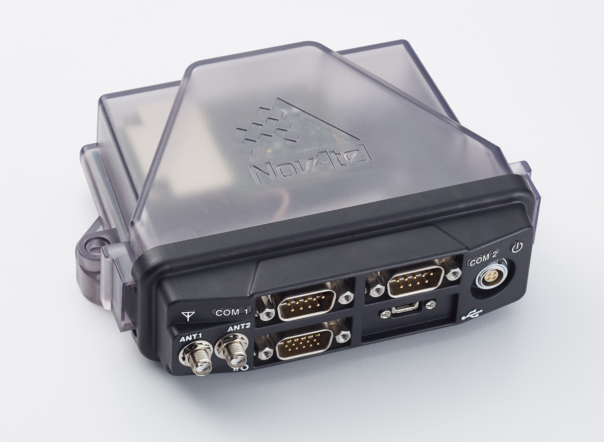
TerraStar-L, a new 40-centimeter (cm) precise point positioning (PPP) correction service, is coming next week from NovAtel.
TerraStar-L is a subscription-based correction service that delivers GNSS correction data via satellite to users of precision navigation systems. With position accuracy of 40 cm, TerraStar-L is designed for broad accuracy applications such as agriculture, geospatial information systems (GIS) and unmanned vehicle navigation, particularly where tree lines, buildings and other obstructions can be an impediment to continuous positioning.
With the addition of the TerraStar-L correction service, NovAtel now offers two levels of PPP corrections through its NovAtel CORRECT positioning engine; the new 40-cm accuracy service and a 4-cm service through its TerraStar-C solution.
By offering two diverse accuracy options, customers have the flexibility to choose the performance level best suited to their application. The correction data for both services provides consistent worldwide accuracy and is delivered over satellite which eliminates the need for a local base station.
“The robustness and redundancy built in to the TerraStar network infrastructure makes TerraStar correction data extremely reliable,” said Sara Masterson, business development manager of correction services at NovAtel. “When our customers operate in environments with obstructions that can block GNSS signals, TerraStar-L offers a repeatable 40-cm solution, reducing position drifts or jumps. This maximizes uptime and productivity for our customers by providing fast initialization to a reliable decimetre position.”
NovAtel CORRECT with PPP combines GNSS satellite clock and orbit correction data from TerraStar’s global reference station network service to deliver solutions with high accuracy and instant re-convergence in challenging environments.
TerraStar-L will be available for order from NovAtel starting May 4.
Harxon has introduced an advanced, high-speed, Bluetooth-enabled wireless data link designed for GNSS/RTK (real-time kinematic) surveying and precise positioning.
The HX-DU1603D is a lightweight, ruggedized UHF receiver designed for digital radio communications between 410 and 470 MHz in either 12.5 or 25 kHz channels, which can be widely used in GNSS/RTK surveying and GNSS precise positioning systems.
ThevHX-DU1603D is equipped with a Bluetooth transceiver for cable-free communications with external devices. It features an internal, rechargeable battery for ease of use and portability that allows long operational hours.
The HX-DU1603D rover radio easy to operate and use. It is equipped with a display screen, and its buttons can be used to configuration all parameters, such as frequency, protocols, power display, serial port baud rate and air baud rate. By deploying the technology, users can instantly communicate with GNSS precise positioning receivers that share the same protocols throughout the world.
The rover radio HX-DU1603D joins the line of Harxon products that include 25W base radio HX-DU8602T with simplex and 35W base radio HX-DU8608D with Duplex.
Fugro has been awarded a supply arrangement by the Canadian Hydrographic Service (CHS) to provide vessel-based hydrographic survey services. Under the contract, CHS will procure hydrographic surveys as needed, anywhere in Canada, to enhance its capacity for data acquisition and processing in support of its nautical charting program.
Hydrographic survey data from ports, harbors, nearshore and offshore regions will be acquired and processed using Fugro’s vessels, equipment and personnel. The resulting data will be used by CHS to update its nautical charts.
The supply arrangement, together with a supply arrangement for airborne lidar bathymetry (ALB) awarded in 2013, will enable Fugro to support Canada in its plans to implement an integrated multi-platform methodology to hydrographic surveying anywhere in Canada, including the Arctic region.
Fugro provides International Hydrographic Organization (IHO) compliant survey services to numerous governments throughout the world.
Leica Geosystems has launched a new antenna for static, long-term projects requiring a high number of sensors. The Leica GMX910 can also enable dynamic monitoring with up to 10-Hz data streaming and advanced multi-frequency, multi-constellation tracking.
Starting with the basic GPS single frequency receiver and adding multiple upgradable options, this antenna fits the needs of diverse monitoring projects, the company said. The antenna supports multiple GNSS satellite systems and signals. Tracking up to 555 channels, this antenna anticipates the future and is ready for ongoing changes in GNSS technology.
The smart antenna is also fully integrated in the Leica GeoMoS deformation monitoring solution and seamlessly connects to Leica GNSS Spider offering high-quality GNSS processing results.
The highest reliability of data streaming is achieved by plugging a cable into the GMX910. An IP67 rating against dust and water, extended temperature ranges and low power consumption enables installation of the device in remote areas and severe conditions.
The Leica GMX910 adapts to a wide range of GNSS monitoring applications, from complex man-made to natural structures. The smallest movements of bridges, dams or high-rise buildings are detected in real-time.
TerraGo has released TerraGo Edge 3.9.3, which features full support for OGC GeoPackage, a universal format for sharing maps and geographic data across mobile devices and all platforms.
TerraGo Edge enables users to import and export OGC GeoPackage as a SQLite database optimized for performance on iOS and Android devices.
“Because we listened to our customers, we designed TerraGo Edge from the ground up to be an open solution for exchanging field engineering, GIS, GPS and asset management data across vendor platforms and devices,” said John Timar, vice president, Worldwide Sales at TerraGo. “GeoPackage is an important win for customers because it’s a dramatic shift away from proprietary formats and technology. GeoPackage breaks through user dependence based on vendor data lock-in, enables platform-independent data exchange and refocuses customer value on software features and performance.”
The latest TerraGo Edge 3.9.3 release closes the loop for a complete GeoPackage collaboration workflow by allowing Edge app users to import GeoPackage data from a mobile device, collect location-tagged field data and roundtrip the information back to the GIS or other enterprise systems of record.
BYOD GPS Gets Real: Lessons Learned with the New Rules of GPS Data Collection
Thursday, April 14, 1 p.m. ET / 10 a.m. PT
In this GPS World webinar, join us as we examine how five organizations from five industries (oil & gas, engineering, water utility, transportation and natural resources) made the switch from GPS handhelds to smartphones and tablets for their field data collection needs. Speakers are Michael Gundling and David Basil, TerraGo.
Version 3.9.3 features these enhancements:
Advanced GIS Integration
Deliver GeoPackage data to any TerraGo Edge mobile app user
Create offline map when GeoPackage is embedded in a GeoPDF
Simultaneously import GeoPDF and GeoPackage data back to Edge server
Improved Mapping Experience with EdgeMap Optimizer
Automatic detection of best resolution (DPI) for offline maps upon import by mobile user
Manually select the optimal resolution upon import
Data collection enhancements with the New Form Template Selection, including a new search function in form fields to improve user productivity and data integrity.