Sokkia has introduced the latest addition to its line of field controllers for use with construction and surveying applications, the SHC5000. Operating MAGNET Field, Site and Layout software, the newest field controller is designed to provide a more versatile and faster handheld computer for GNSS receivers and total stations, with the largest screen size in the Sokkia line.
“The SHC5000 boasts a 7-inch sunlight-viewable screen, which makes it the largest in our line of field controllers,” said Ray Kerwin, director of global surveying products. “The display’s capacitive touch interface comes with finger, glove, small tip stylus and water capable options. Operators can change the screen from portrait to landscape when viewing maps or drawings, depending on which orientation is preferable.”
The SHC5000 comes with two built-in cameras. One uses an 8 MP camera with autofocus and LED flash that is designed for uses such as field photography. The second has a 2 MP camera on the front side of the unit for purposes such as video meetings.
Additional features include 64 GB of flash storage, an optional 4G LTE cellular modem, internal GPS navigation, Bluetooth and Wi-Fi, and a battery life of 10-plus hours.
Topcon Positioning Group has released the latest addition to its ES total station series, the ES-50. Featuring advanced reflectorless capabilities, the new ES-50 is designed to provide an entry-level total station option with a fast and powerful electronic distance meter (EDM).
“With the functionality of many high-end robotic total stations, our ES series is known to be full-featured and ready to tackle modern job sites,” said Ray Kerwin, director of global surveying products. “The ES-50 incorporates all those time-honored expectations, along with a reflectorless EDM of up to 350 meters, and 4,000 meters with the use of a prism.”
The ES-50 offers 2- and 5-arc second accuracies for distance measurements in projects such as land surveying, topography and as-built, construction and layout, or foundation and exterior job sites.
Additional features include a battery life of up to 15 hours, dual-axis compensation, a waterproof design and a laser pointer.
Piksi is a low-cost, high-performance GPS receiver with real-time kinematic (RTK) functionality for centimeter-level relative positioning accuracy.
Its small form factor, fast position-solution update rate, and low-power consumption make Piksi ideal for integration into autonomous vehicles and portable surveying equipment. An open-source architecture with a high-performance DSP on-board and our flexible correlation accelerator make it the perfect platform for GNSS research.
Piksi is designed for autonomous vehicle guidance, such as formation flight and autonomous landing; GPS/GNSS research; and surveying systems.
Swift Navigation is a San Francisco-based startup building centimeter-accurate GPS technology for automotive, surveying, robotics, agriculture and drones.
The company says its products are 100 times more accurate than the GPS in a cell phone, at a tenth of the price of the competition.
In November, the company raised $11 million in a series-A investment round led by Pierre Lamond and Lior Susan at Eclipse Ventures. Swift Navigation plans to use the funds for taking current customers to scale and growing their team, with a focus on core engineering. Another focus continues to be research and development, with a second new product due out this year.
Advanced Navigation has released its GNSS/INS post processing software Kinematica.
Kinematica is designed to be an easy-to-use GNSS/INS post-processing software that allows users to process raw GNSS and inertial data after collection and achieve higher accuracy position, velocity and orientation than is possible in real time.
Kinematica has been released as free software with a time lock to Aug. 1, 2016.
The software supports kinematic GNSS positioning, which provides a 200x increase in position accuracy over standard GNSS with 8-mm position accuracy. Dual antenna GNSS heading processing is also supported.
Kinematica processes data in forward and reverse six times, which allows it to fill any satellite outages and ignore errors that would normally affect a real-time solution. Both loosely and tightly coupled GNSS/INS processing is supported and the software automatically switches between each mode depending upon the environment.
Kinematica supports all of Advanced Navigation’s GNSS/INS products. Support for a wide range of third-party systems is scheduled for the next update in July.
Kinematica is targeted at surveying, scanning and aerial photography applications that need to squeeze the maximum performance out of their systems.
Eos Positioning Systems has introduced a comprehensive RTK NTRIP app for Android that works with its Arrow line of RTK GNSS receivers. An Arrow GNSS receiver combined with the NTRIP app turns an Android smartphone or tablet into a powerful data collector capable of recording 1-centimeter accurate GIS data in real-time.
“We designed Eos Tools Pro for the RTK user,” said Chief Technology Officer Jean-Yves Lauture. “It is, by far, the most comprehensive NTRIP app for Android on the market today, turning smartphones and inexpensive Android tablets into powerful high-precision GNSS data collection devices.“
The app, named Eos Tools Pro, has user-configurable audible and visual alarms to alert the user of high PDOP, lost RTK correction, unacceptable correction age and several other important metrics. It supports all current and future constellations (GPS, GLONASS, Galileo and Beidou).
To eliminate any confusion as to which GPS/GNSS device the user’s app is using, Eos Tools Pro features a dropdown menu so the user may select any receiver the Android device has been paired with.
“The Eos Tools Pro app enables Android devices running Esri’s Collector app on Android smartphones and tablets to collect data as accurate as 1cm when connected to an Arrow GNSS receiver,” said Esri Product Manager Jeff Shaner. “It’s a big leap forward to enable Collector to serve the high-precision GNSS user.”
Google Maps is tightly integrated with the app to display the user’s location anywhere in the world. Detailed satellite information such as a skyplot that plots each visible satellite, whether it’s being used or not, and signal strength bar graphs from each constellation are also displayed. Finally, a Terminal screen displays the NMEA data flowing and allows the user to send commands to the receiver.
Eos Tools Pro and Arrow receivers are targeted at high-accuracy applications like GIS; environmental; agriculture; electric, gas, water utilities; surveying; machine control; and federal, state, and local government.
Garmin International has acquired PulsedLight Inc., a privately held designer of optical distance measurement technology in Bend, Oregon.
PulsedLight makes sensor boards that are highly accurate, small and lightweight. PulsedLight developed and owns the intellectual property that enables this technology, Garmin stated in a news release.
PulsedLight is the maker of the LIDAR-Lite, an optical distance measurement sensor for automotive blind-spot sensing, smart city traffic monitoring, 3D image scanning, collision avoidance, industrial measurements, security system components and other applications.
“Optical distance measurement technology fits in nicely with Garmin’s core competencies of location and positioning,” said Cliff Pemble, Garmin president and CEO. “We are delighted to add PulsedLight and their capabilities to the Garmin portfolio.”
“We are excited to have the support of a technology leader like Garmin. They are able to provide the resources and manufacturing expertise to integrate our technology into incredibly useful new devices that serve a multitude of markets,” said Dennis Corey, president and co-founder of PulsedLight. “We look forward to an exciting future under the Garmin umbrella.”
The PulsedLight office and its design associates will be retained by Garmin International. Financial terms of the acquisition will not be released.
Windows 10 and a new large display are key features of Juniper Systems’ latest tablet, Mesa 2 Rugged Tablet, released today.
Juniper Systems is a provider of ultra-rugged field data collection solutions.
Featuring the largest display produced by Juniper Systems to date, the Mesa 2 is also Juniper Systems’ first handheld to run on the new Windows 10, which the company said allows for improved decision-making in the field, as well as smooth transitioning from field data collection to office work and back.
With a full Windows 10 operating system, the Mesa 2 provides users with access to a broader range of software options to meet their data collection needs and is powerful enough to use in place of a desktop computer when in the office. The Mesa 2’s 7-inch display strikes a perfect balance between providing ample viewing area for collected data and reducing overall weight for minimal fatigue and superior, all-day comfort, the company said.
The Mesa 2 is designed to perform reliably in harsh environments, and is the only IP68-rated rugged Windows tablet available, providing complete protection against water and dust. It maintains a seal while its ports are in use, while most other tablets on the market are exposed to damage from water and dust if the port cover is not securely in place.
The Mesa 2 also features an extraordinary IllumiView display, providing best-in-class visibility in any lighting conditions, and its chemically-strengthened Dragontrail glass touch screen provides superior durability, reducing haze from surface scratches and cracks normally caused by accidental impact.
The Mesa 2 battery provides users with a full 8-10 hours of runtime, allowing for maximum productivity throughout the workday. Users may also purchase an optional expansion battery from Juniper Systems that provides an additional 4-5 hours of runtime plus hot swap capabilities for those extra-long days where overtime is required.
“The Mesa 2 is in a new sphere relative to our other ultra-rugged devices,” said Nate Holman, Director of Sales and Marketing at Juniper Systems. “While it features the same degree of outstanding quality and ruggedness as other Juniper products, the Mesa 2 provides users with more software options and greater processing capabilities, due to its full Windows 10 operating system and Intel quad-core processor. The Mesa 2 is designed to improve productivity along every point of the data collection process, from the initial planning and gathering of data, to the later data analysis, and finally through the decision-making process. It’s a tablet optimized for efficiency, designed to be ‘your office, anywhere’.”
The Mesa 2 Rugged Tablet will begin shipping in the first quarter of 2016.
Pre-GPS techniques actually responsible for the Greenwich shift
By Stephen Malys, John H. Seago , Nikolaos K. Pavlis, P. Kenneth Seidelmann and George H. Kaplan
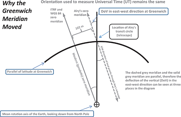
The historical prime meridian runs through a telescope established in 1851 by Sir George Airy at the Royal Observatory at Greenwich, England. It was adopted as an international standard as the prime meridian for zero longitude in 1884 during the International Meridian Conference held in Washington, D.C.
The observatory’s line in the pavement is a major tourist attraction, but the prime meridian used by satellite navigation systems is located 102 meters east of that historic location (see Figure 1).
Some people mistakenly thought that GPS, or the earlier Navy Navigation Satellite System (Transit), was responsible for this offset. But research, recently published in the Journal of Geodesy, concludes that the zero longitude used by GPS arrived at its current location in 1984, before GPS existed as an operational system.
The orientation of the World Geodetic System 1984 (WGS 84), and therefore the direction of the prime meridian associated with WGS 84, was established when the U.S. Defense Mapping Agency (now part of the National Geospatial-Intelligence Agency) adopted the orientation of an international scientific standard known as BTS 84, the BIH Terrestrial System 1984.
The Bureau International de l’Heure (BIH) was a predecessor to the International Earth Rotation and Reference Systems Service (IERS). Unlike previous terrestrial systems of reference used by the BIH, the BTS 84 was not established by tracking stars with optical telescopes.
BTS 84. BTS 84 was created using geodetic techniques known as satellite laser ranging, lunar laser ranging and very long baseline interferometry. While satellite Doppler tracking (Transit) data was included in the BIH process, this data type did not contribute to or constrain the orientation of BTS 84.
When an optical instrument is leveled, even to the highest accuracy achievable, its orientation is controlled by the gravity field’s vertical direction at that particular location.
The astronomical zenith, or “up” direction realized by a telescope, is perpendicular to the gravity equipotential (level) surface locally, and therefore is in general deflected from the geodetic zenith that is perpendicular to our best-fitting global ellipsoid model of the Earth due to small irregularities of the gravity field (hence the term deflection of the vertical, DoV).
As a consequence, the astronomical meridian plane at an arbitrary location on the Earth does not necessarily contain the center of mass of the Earth (FIGURE 2).
FIGURE 2. Geometry showing why the Greenwich meridian moved.
Astronomical Time. When optical systems were finally retired from Earth-orientation service by the BIH in 1984, the BIH continued the measurement series for Earth’s rotation by modern geodetic techniques, but required continuity in the determinations. These measurements included those for astronomical time, UT1.
Requiring continuity in UT1 was equivalent to requiring that the plane of the prime meridian keep its orientation, relative to the celestial sphere, as a function of time. But now — for the first time — there was also a requirement to pass this plane through the center of mass of the Earth.That requirement, along with the DoV at Greenwich, moved the trace of the prime meridian on the Earth’s surface in the vicinity of Greenwich by 102 meters to the east of Airy’s telescope (Figure 2).
Journey to the Center of the Earth.Thanks to satellite-tracking techniques, we now know the location of the center of mass of the Earth with an accuracy of about 1 centimeter in three dimensions — about the size of a U.S. dime.
In 1984, its location was known with an accuracy of about 1 meter. When Airy set up his special telescope (called a transit circle), knowledge of the size, shape and center of mass of the Earth was limited to several hundred meters.
The trace of the historical astronomical prime meridian established by Airy’s instrument, and the location of zero longitude indicated by GPS receivers, are both consistent with their own conventions, and their offset from each other does not imply an error in either determination.
Stephen Malys and Nikolaos K. Pavlis work for the National Geospatial-Intelligence Agency.
John H. Seago is with Analytical Graphics, Inc.
P. Kenneth Seidelmann is a member of the Astronomy Department, University of Virginia.
George H. Kaplan is a contractor with the United States Naval Observatory.
The Spanish navy is using UAVs for intelligence operations on the northern and eastern coasts of Somalia to locate possible illegal activities. This past summer, the navy used the Scan Eagle unmanned air system during Operation Atalanta, a European Union mission combating piracy in the Indian Ocean.
The Scan Eagle system, deployed from the amphibious assault ship Galicia, produced valuable intelligence for the Naval Force of the European Union (EUNAVFOR). The system consists of four aircraft, one of which is designed to acquire night images.
The New Spanish Armada: Sailors onboard Galicia in the Indian Ocean prepare to launch a Scan Eagle on a surveillance mission. (Photos: Spanish Ministry of Defense)
The Scan Eagle is launched via a catapult, and lands by means of a pole, into which the aircraft is “locked.” A set of antennas sends and receives information between the control station and the UAV.
The system can operate continuously for more than 18 hours at a stretch, collecting data, images and video both day and night.
During Operation Atalanta, the Scan Eagles completed more than 175 flight hours, collecting imagery for more than 11 hours without being detected and providing command with real-time images of possible targets.
The UAV system was also deployed in Afghanistan, where it operated from the advanced support base of Qala i Naw until the withdrawal of the Spanish contingent in 2013.
The mission represents a milestone for the Spanish navy — the first remotely piloted aircraft operating successfully from a navy vessel.
Night eyes: One of the four UAVs deployed was equipped for night imagery. (Photo: Spanish Ministry of Defense)Control Station: From the ship’s hangar, the UAV is controlled by operators of the new 11th aircraft squadron of the Spanish Navy. (Photo: Spanish Ministry of Defense)
High-tech aerial laser surveying is being employed to reveal the hidden archaeology of an Iron-Age hill settlement in Lancashire, England.
Visually, the archaeological features are difficult to see, but a Bluesky laser survey, commissioned by the Morecambe Bay Partnership, is expected to reveal previously undiscovered details of a settlement at Warton Crag. Identified as an important Heritage at Risk site, the site has already been subject to low-level archaeological investigations, which have identified remains from a small, well defended hill fort.
“It is imperative that we get a better definition of the archaeological remains that are currently ‘hidden’ by the dense vegetation cover,” said Louise Martin, H2H cultural heritage officer at the Morecambe Bay Partnership. “This will enable us to develop conservation strategies for the site and work towards reducing the risk to the archaeological remains. The site is currently on Historic England’s ‘at risk’ register, so this work is crucial in developing partnerships and strategies to protect the monument for future generations.”
The Bluesky lidar system uses lasers to accurately measure the earth’s terrain and record features on the ground in 3D. A dedicated survey plane is equipped with aerial photography equipment and will fly over the site during the winter months when the tree and canopy cover is at its minimum.
Bluesky will process the millions of individual laser measurements to create detailed 3D computer models of the Earth’s relief — a Digital Terrain Model (DTM) — and ground surface including buildings and vegetation — a Digital Surface Model (DSM). This will allow the Morecambe Bay Partnership to model scenarios and strategies and share information with project partners.
Geneq has introduced a new “all-in-one” GPS, GNSS and RTK Data Collector Series, the SXPro.
The professional-grade series of handheld receivers is accurate, rugged and competitively priced, the company said.
Standard features include an extra-long battery life of more than 10 hours on a charge as well as a large outdoor-viewable touchscreen. The handhelds are rated IP65 for protection against water and dust.
The SXPro handheld is also equipped with a 5-megapixel autofocus camera and Microsoft utilities. The SXPro is sold as a fully loaded package that includes a spare battery, hard carrying case and Field Genius Survey Data Collection software.
The SXPro series is built for mobile survey and GIS users for applications such as water, electric and gas utilities; transportation; mining; agriculture; and forestry.
The SXPro RTK (real-time kinematic) model offers 220 multi-constellation channels for centimeter accuracy with RTK networks. A surveyor-grade external dual-frequency antenna and cables are included.
The SXPro GNSS offers 372 multi-constellation channels for sub-meter accuracy with SBAS corrections.
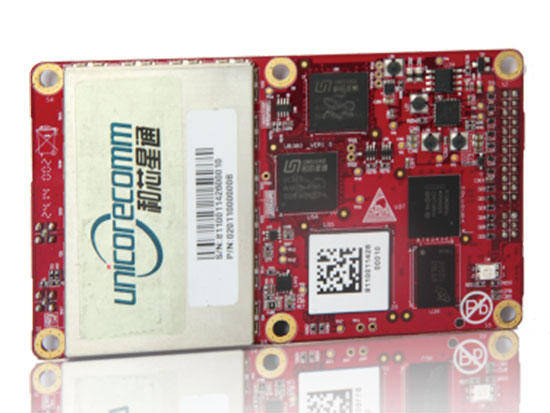
The UB380 GPS/GLN/BDS tri-constellation octa-frequency high-precision board.
High-end GNSS board
For high-precision positioning, navigation and GBAS applications
The UB380 multi-GNSS receiver has 384 channels, based on Unicore’s multi-GNSS system on a chip. It features Unicore’s latest real-time kinematic (RTK) engine, which can process triple-frequency BDS and GPS and dual-frequency GLONASS observation data. This can significantly reduce initialization time, improve position accuracy and enhance reliability in difficult environments such as city canyon and canopy, as well as make the long baseline RTK possible. The receiver board can support GPS L1, L2 and L5; GLONASS L1, L2; and BDS B1, B2 and B3. The support of GPS L2P and L2C can satisfy the high-precision requirements of GBAS reference station equipment. The UB380 is compatible with industry-standard GNSS boards in size, interfaces and electrical standards.
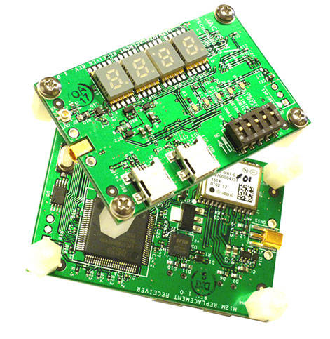
M12M Replacement Receiver GNSS module. Photo: Jackson Labs Technologies
Legacy receiver module
Plug-and-play upgrade for xli server, fury GPSDO
The M12M Replacement Receiver released is form, fit and function compatible to the legacy Motorola M12M and M12+ timing and navigation receivers. It uses an eighth-generation GNSS timing-enabled receiver, allowing 72 GNSS-channel reception with any two GNSS systems being received simultaneously. It adds configurability via USB ports and dual in-line package (DIP) switches and various status displays. GPS, GLONASS, BeiDou, QZSS and SBAS signals can be received. The module supports NMEA, Motorola binary and u-blox binary as well as SCPI (GPIB) communication protocols; is designed to allow plug-and-play retrofit of equipment designed for legacy Motorola receivers; and is certified as a plug-and-play upgrade to the Symmetricom/Microsemi XLI server and the Jackson Labs Technologies Fury GPSDO. It can be used to retrofit products for GLONASS/BeiDou compatibility. The module enhances performance parameters such as time to first fix; position, velocity and timing accuracy; tracking sensitivity; the addition of SBAS (differential compensation) capability; and the addition of external interfaces such as USB and a synthesized frequency output.
High-gain, high-rejection family designed for cell and telecom
The TW3150/52 antennas feature a 50-dB low-noise amplifier (LNA) gain to handle long cable runs often associated with installation on telecommunications towers. They cover the GPS L1 and SBAS (WAAS, EGNOS and MSAS) frequency bands and provide excellent cross-polarization rejection and enhanced multipath rejection.The TW3150 antenna features a four-stage dual-filtered LNA, while the TW3152 antenna includes an additional SAW pre-filter. This provides better than 80-dB of signal rejection above 1610 MHz and below 1545 MHz. The antennas are IP67 and MIL-STD-801F Section 509.4 compliant to withstand challenging environmental conditions.
Provides support for GPS, GLONASS and BeiDou with MediaTek
The ORG1510-MK Multi Micro Hornet is a fully integrated multi-GNSS (GPS, GLONASS and BeiDou) module. The miniature low-power architecture is designed to provide a GNSS component to devices that require fully featured components with small footprints, such as UAVs designed to follow action sports and other fast-moving activities or wearables. The ORG1510-MK contains the MediaTek MT3333 chip, which supports a fast update position calculation rate, and contains an onboard flash memory that does not erase when power is off. It consumes little power with the use of both standby mode and backup mode, and, in advanced applications, a periodic mode that can turn the device on and off when in backup or standby.
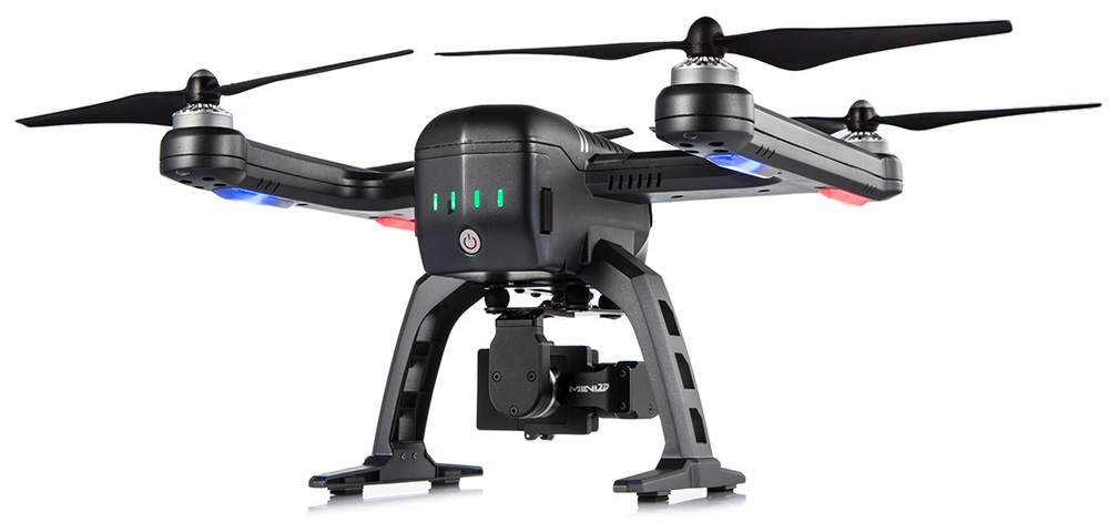
Designed for recording sports activities, the FLYPRO XEagle UAV has replaced traditional UAV remote controllers with the XWatch, a smartwatch designed to control the XEagle. Users can control the devices to take off, land and follow, as well as adjust flight height with one click on the wrist within 300 meters. The smartwatch design enables users to fly the aerial vehicles to take high-definition pictures and videos while engaging in intense sports. A voice-control feature allows users to fly the XEagle without moving their hands using commands such as “FLYPRO, take off” and “FLYPRO, follow me”.
Thermal imaging camera core designed for integration
FLIR Tau 2 thermal imaging cameras are suited for demanding applications like UAVs, thermal weapon sights and handheld imagers. Improved electronics now give Tau 2 even more capabilities, including radiometry, increased sensitivity (<30 mK), 640/60 Hz frame rates, and powerful image processing modes that dramatically improve detail and contrast. Since the electrical functions are common between the Tau 2 640, 336 and 324, integrators have direct compatibility between the different camera formats, and Tau camera versions share many of the same lens options.
Amazon’s latest version is designed to deliver packages in 30 minutes
Source: Amazon
A new drone design introduced by Amazon for its planned Prime Air Delivery service is larger than the previous quadcopter and has a more advanced design, including the ability to operate with an auto-loading system that sets the payload inside an internal carrier bay. The hybrid design combines vertical lift and horizontal flight capabilities using lift fans and a pusher prop. The drone is capable of flying at an altitude of about 400 feet (122 meters) at about 55 mph (88 km/h) for a range of 15 miles (24 kilometers). It has sense-and-avoid situational awareness technology and is designed to deliver small packages in under 30 minutes.
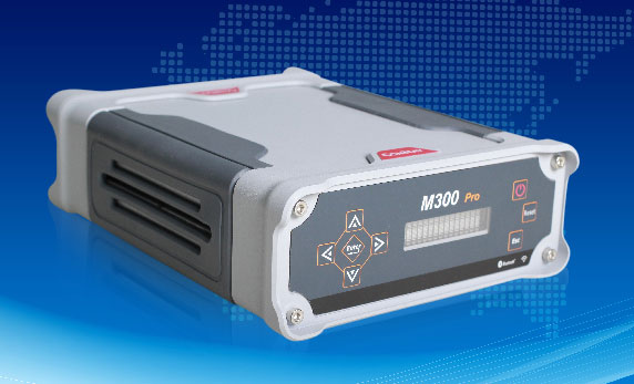
The M300 Pro is a multi-purpose CORS GNSS receiver designed for applications such as positioning infrastructure, active geodetic network, deformation monitoring, machine guidance, harbor construction, land surveying and marine surveying. Designed for reference stations, the M300 Pro tracks GPS, GLONASS and BeiDou (B1, B2, B3), and will track Galileo, QZSS and other coming constellations. Its web server function enables remote control for access, configuration, programming, data download, reboot/restart, firmware update and code registration. It is compatible with many kinds of CORS software, using the standard data format RTCM and the various data transfer protocols such as UDP, TCP and NTRIP. Raw GNSS observation data can be saved in RINEX format and remotely downloaded. Multiple ports can be configured and connected with external sensors such as meteorological sensors, barographs and inclinometers. The PPS output function provides a guarantee for precision timing. It also has the functionality of event mark and external memory.
The Leica Velocity and Displacement Autonomous Solution Engine (VADASE) detects fast movements of man-made and natural structures in real time, running on board Leica reference stations and monitoring receivers. VADASE provides an in-depth look at accurate, high-rate velocity and displacement information of various activities and structures. It gives engineers and researchers complete, precise and reliable monitoring information. VADASE delivers actionable information independent of any GNSS real-time kinematic (RTK) correction service.
GNSS receiver with onboard memory for data storage
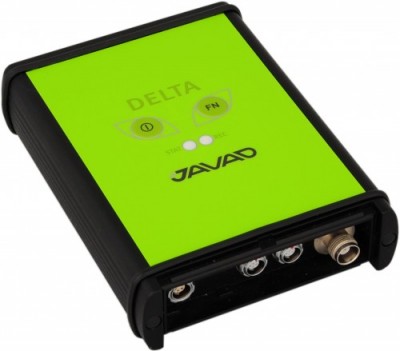
The DELTA-3 receiver has 864 GNSS channels, along with three powerful processors and program memory in a single chip, which uses less power and makes the total system less expensive. The 864 channels allow tracking of all current and future satellite signals. Delta-3 can track and decode the QZSS LEX signal messages. It is a powerful and reliable receiver for high-precision navigation systems, including high-dynamic systems, for machine and traffic control, high-precision surveying, and geodynamics and aerogeophysics applications. Delta-3 can operate as a receiver for post-processing, as a Continuously Operating Reference Station (CORS), or as a portable base station for real-time kinematic (RTK) applications, and as a scientific station collecting information for special studies such as ionosphere monitoring.
A configuration of ArcGIS and a JavaScript application
Photo Survey is designed for local governments to publish street-level photo collections and conduct focused property surveys that can identify blight, damaged structures or construction activity. It leverages location-enabled photos produced by many commercially available cameras and simplifies data processing so street-level photo collections can be gathered on a regular basis. Photo collections can then be combined with relevant survey questions in an ArcGIS Online map, and shared with the Photo Survey application. Once complete, the Photo Survey application can be used by the general public or local government staff to review street-level photos and complete property surveys.
 “The SHC5000 boasts a 7-inch sunlight-viewable screen, which makes it the largest in our line of field controllers,” said Ray Kerwin, director of global surveying products. “The display’s capacitive touch interface comes with finger, glove, small tip stylus and water capable options. Operators can change the screen from portrait to landscape when viewing maps or drawings, depending on which orientation is preferable.”