Researchers, program managers, industry executives, and innovative product developers must chart a path to success through a challenging landscape of change in global navigation capabilities and expansion in markets.
Who are the leaders who will move the industry forward in 2006 and 2007? What strategies will they employ and what risks will they undertake? In this special report, GPS World looks ahead to identify the key influentials most likely to impact the industry this year and next.
As distinguished and accomplished as these individuals are, they are not the only leaders moving the industry forward. Far from it. If we used the entire length of this magazine, we might have room enough to profile all the people deserving this level of recognition. So, our selection had to be a bit, well, selective. And it may be arbitrary on many counts. But we will do it again, and there will be time and room enough to include more new faces in recognition of the fast-growing nature of the GNSS industry.
Our only rule in compiling this gallery was that the members of the magazine’s Editorial Advisory Board, who nominated most of those shown here, were themselves excluded from appearing, even though they all exemplify leadership and vision, with long careers and many important projects underway. In the end, we had to violate even that rule, as so many advisors nominated two of their number, that we did include them.
You will hear more from these individuals — in the pages of GPS World, in technical conferences, in top-level industry and agency meetings. Whenever you have the chance to hear or talk with them, take it.
Suman Ganguly
President | Center For Remote Sensing, Inc.
Ganguly assembled a group of researchers under the banner of Center For Remote Sensing, Inc. (CRS), a relatively small firm, and has carried out advanced GPS technical R&D, developing the first (or one of the first) software GPS receiver. CRS pioneered software radio technology before 1990, in communication and radars supported by the Defense Advanced Research Projects Agency and the National Science Foundation. CRS adapted these technologies for software navigation systems and currently supports advanced navigational system developments (including a variety of receivers and simulators) for several Department of Defense organizations. Involved with various software-based navigation systems, software radars, software communication systems, and related areas, Ganguly plans to continue innovating in all areas of GNSS and related fields.
Michael E. Shaw
Director, National Space-Based Positioning, Navigation, and Timing (PNT) Coordination Office
As head of the new PNT Coordination Office, Mike Shaw takes a more independent role as arbiter and coordinator of U.S. policy, gaining a reputation among Assistant and Deputy Secretaries as the go-to-guy for the straight talk on GPS issues. “In light of the unprecedented growth in GNSS constellations and signals, our goal in the Coordination Office is to support the U.S. National Space-based PNT Executive Committee in improving U.S. policy and management framework governing GPS and its augmentations to ensure that this technology continues to fuel the engine of economic growth and opportunity in the United States and throughout the world.”
Tim Murphy
Technical Fellow | Boeing Commercial Airplane Group
Involved in many aspects of communications, navigation, and surveillance to support future air traffic management, with a particular focus on GNSS, Murphy has helped deploy and test GNSS landing systems (GLS) using Ground Based Augmentation Systems (GBAS, also known as Local-Area Augmentation Systems, or LAAS) in several places around the world. He’ll move ahead with new operational procedures to improve airline operational efficiency and safety through use of Required Navigation Performance (RNP), much of it enabled by GNSS. “And Boeing will continue to support the extension of GBAS standards to include new levels of performance that can support GLS CAT II/III operations.”
Elizabeth Cannon
Professor and Head, Department of Geomatics Engineering Schulich School of Engineering | University of Calgary
Calgary has become a key source of highly-trained GPS/GNSS specialists for both industry and other advanced research institutions. While directing studies and actively recruiting new graduate students, Cannon’s own research currently focuses on precise vehicle positioning systems that integrate GPS with low-cost inertial systems and dead-reckoning sensors. “We will also continue to analyze the new GPS (particularly L5) and Galileo signals to determine how we can best exploit these signals for precise positioning.”
Stephen Verhoeff
President and Chief Executive Officer CSI Wireless
“We are excited about our future in this business as applications for GNSS mature and new ones emerge. We have learned over more than 15 years of involvement in this industry that product development, adoption rates, market awareness, and human understanding of technology all take longer to develop than what we first expect. Within this context we look forward to 2006 and 2007 as more capability is put into space, and as we drive more innovation into this market that we serve.”
Patrick McDougal
Vice President, Corporate Development | Inmarsat
Inmarsat’s mobile satellite services are already integrated with GNSS, as the satellites re-broadcast GPS corrections for both EGNOS and WAAS. And Inmarsat will have overall management leadership in the newly formed Galileo Operating Company. “Due to open standards, interoperability, and converging technologies, the distinction between communication networks and positioning services will fall by the wayside,” says McDougal. “The opportunity for Inmarsat will be to tap into the revenue potential of these converging technologies. We know from our own provisioning experience that additional benefits such as increased position accuracy, system integrity, and service authentication are attractive to our customers. These benefits, to be offered by Galileo, will help to expand the market for GNSS and will further the use of mobile satellite communication networks as delivery infrastructure.”
Stig Pedersen
Senior Director of Strategic Marketing Thales
“At Thales I study coming market and technology trends, but I also hope to influence them. My drive is to capitalize on trends like value-based GIS solutions and the increasing spatial awareness in the world, made more popular through products like Google Earth. These concepts can unlock the imagination of people who have never considered how GIS coupled with the latest communication technologies can enable better business. My goal is to increase the size of the market, at all levels, by implementing cost-effective, high-quality solutions that are easy for any business to adopt.”
John T. Kelly
Technical Director for Advanced System Development Sensor Systems Government Systems, Rockwell Collins
“Amid the cornucopia of signals and whirlwind change, three constants exist. First, change is cyclic, and the historic pattern between reliance on external sources for navigation versus more autonomous means may peak shortly towards externally dependent approaches. Second, increased concern regarding security and fraud underscores the importance of access control and anti-spoofing, especially for militarized use. Lastly, adaptability and innovation are even more important to keep pace with change and to develop applications extending GNSS utility beyond its navigation-only roots.”
Per Enge
Research Professor | Stanford University
A key educator as well as researcher, Enge turns out a yearly crop of new PhDs whose R&D impact augments his own direct work. “My immediate goal is to complete the most challenging aspects of the safety analysis for the local area augmentation system (LAAS). Rare ionospheric events have proven to be the most vexing fault mode, and the Federal Aviation Administration-led team is closing in on the solution. My more long-term goal is to launch the Stanford Center for Position Navigation and Time, where we will foster the technology that will enable GPS operation in challenging signal environments — including obstructions and radio frequency interference.”
Jocelyn Vigreux
President | TomTom US A
“TomTom will continue to push the envelope of innovation in 2006. Our focus has been and always will be navigation, however in 2006 TomTom will introduce products that not only help people get from A to B, but that help people get from A to B better, with a focus on personalization. Features such as the ability to listen to audiobooks, hear traffic and road conditions, and iPod compatibility are some of the ways TomTom incorporates personal lifestyles into our new navigation products. TomTom caters to the masses and plans to bring products to market that can be incorporated into everyone’s life.”
Jim Sennott
President | Tracking and Imaging Systems Inc.
A small-business owner doing advanced GPS technical R&D, Sennott was one of the first to patent deeply integrated GPS receiver processing. “We will continue to offer our customers robust and highly accurate GNSS solutions in challenging reception environments: high dynamics, signal blockage, multipath, and jamming. Integration of selected GNSS engine and inertial measurement unit (IMU) sensor components with our Integrated Demodulation-Navigation and Optimal Diversity processors provides a cost-effective path for achieving desired accuracy, continuity, and integrity levels in military and civilian landing systems, test range truth systems, and vehicular guidance applications. In the coming year we look forward to upgrading our integration facilities and simulation tools to support the latest GNSS sensor and IMU technology to meet unique customer requirements.”
Karen Van Dyke
National Technical Expert for GPS | RITA/Volpe Center U.S. Department of Transportation
“The U.S. Department of Transportation (DOT) faces challenges in harmonizing and coordinating research for improved use of GPS and development of augmentation systems. Currently, GPS activities are dispersed across the Operating Administrations. Without a management structure to coordinate research activities, there is the risk of duplication of effort and resources. The Volpe Center, as part of DOT’s Research and Innovative Technology Administration (RITA), will identify and track current GPS transportation applications and research activities across all DOT modal administrations; determine the GPS research activities that should be undertaken which are not being performed; identify current resources and resource gaps within DOT; identify where future GPS research efforts should be focused; and promote coordination and leveraging of GPS technical capabilities across DOT to prevent duplication of effort. RITA also will lead development of the national Positioning, Navigation, and Timing (PNT) Architecture effort on behalf of DOT.”
Hans-Juergen Euler
Leica Research Fellow | Corporate Technology and Innovation Leica Geosystems AG, Switzerland
As Galileo materializes into an accessible system over the next few years, Euler plans a variety of activities using the signals provided in the in the German Galileo Test and Development Environment (GATE). “Then Galileo signal analysis paperwork meets reality. Leica Geosystems’ ideas for future processing approaches can be tested with actual combined GNSS signals. Future applications for our surveying and machine automation solutions will be even more distance-independent and robust because of combined satellite constellations.”
Steven W. Berglund
President and Chief Executive Officer | Trimble
Trimble’s technology strategy has expanding GNSS capabilities at its core. The company released an L2C-capable product a full year before launch of the first IIR satellite capable of broadcasting that signal. Its R8 GNSS system and NetR5 reference station represent initial steps in product concepts that encompass GPS next-generation signals, GLONASS, and Galileo. Berglund says the company will continue to “anticipate satellite infrastructure improvements. Our plans for 2006 and 2007 are to continue to release new products consistent with this expanded GNSS architecture, contemplating the continued development of the Galileo system. Our goal remains that of offering solutions that meet our customers’ needs by using the best technology available, now and in the future.”
Neri G. (Tom) Terry, Jr.
Geospatial Information and Services (GI&S) Plans and Policy Officer U.S. Marine Corps Headquarters
“One area we emphasize is full integration of the Global and National Spatial Data Infrastructure (NSDI) and GPS for our military operating forces and other users of GPS. To this end, representatives at all levels of government and the private sector are collaborating to implement a non-proprietary standards-based grid. This grid will serve as a language of location, optimized for local operations — enabling geo-addressing and a universal map index. This effort will reduce operational friction, improving the speed and efficiency of both precision operations and emergency response.”
Javad Ashjaee
President and CEO | Javad Navigation Systems
“In the last few years, I could not be as effective as I would have liked due to situations beyond my control. However, I am currently enjoying my independence and looking forward to a new beginning. I still spend about one-half of my time in Moscow. A frozen lake and abundance of snow there last winter introduced me to a new hobby, snowmobiling, and provided me with a nice break from work on technology. With new GPS signals, new GLONASS structures, and the Galileo ICD on the horizon, and my complete independence, I look forward to a new round of technology challenges. I have started a new venture and am fortunate to have a group of gifted colleagues with me. I am extremely excited about the possibilities that the coming years will bring.”
Sang Jeong Lee
Korean GNSS Task Force | Professor Chungnam National University, Korea
In one of the world’s fastest-developing wireless and location-based services markets, Lee believes that “GNSS technology must add value to IT-related markets, especially to the wireless network market. Hence, GPS/Galileo receivers and assisted-GNSS technology will be developed.” Further, “in this kind of digital convergence market, safety should be one of the most important impact factors. In this regard, we will investigate interference mitigation technology and integrity monitoring schemes.” Finally, he will help develop plans for a regional integrity monitoring system to be deployed as part of the Korean national infrastructure.
Rob Rovetta
Senior Director of Product Management QUALCOMM CDMA Technologies
With 150 million gpsOne cell phones and 500,000 Omnitracs units, QUALCOMM may be the world’s largest GPS manufacturer, by unit volume. “The adoption of GPS-enabled location services on wireless networks is accelerating in North and South America, Europe, Asia, and elsewhere around the world. QUALCOMM focus will be to expand the location services available to wireless users by enhancing our gpsOne positioning technology’s capabilities and further integrating position location into multimedia services. We will work closely with network operators, device manufacturers, and application developers and publishers to deliver a location-enhanced mobile experience to people everywhere.”
Daniel Ammann
Vice President of Research and Development, GNSS Software | u-blox
u-blox is diversifying its portfolio to fit the needs of a wider clientele, from provision of assisted GPS (AGPS) and similar services through the development of specialist applications such as timing receivers to low-cost receivers for mass-market consumer products. Amman targets meeting ever-lower power requirements and shrinking die sizes, while incorporating next-generation navigation signals such as Galileo, L2C, and QZSS in multi-band, multi-system GNSS receivers. He will spearhead research efforts “exploring innovative ways of using non-GPS signals for navigation purposes as well as, as always, the challenge to achieve ever-higher sensitivity, accuracy, and reliability levels.”

Logan Scott
President LS Consulting
“Location-based encryption and authentication provides an added layer of security by forcing users to be at particular locations and times to access or generate data. This is in addition to knowing the correct keys. Financial transactions, credit report security, medical records keeping, privacy protection, digital cinema transport, and military database protection are among the myriad applications. Currently I’m working with GeoCodex LLC on integrated GPS/cipher devices for use in a variety of security products. Authenticating the position solution using a variety of antispoofing techniques is one of the major challenges, particularly for the civil user.”
Hideto “Duke” Takahashi
Assistant General Manager, Space Business Strategy Aerospace & Electronics System Division | ITOCHU Corporation
“With the launch of GIOVE-A and renewed Russian interest in accelerating GLONASS, it appears the global positioning, navigation, and timing (PNT) environment will emerge from GPS domination. Most states depending on these signals rely on external systems operators for PNT services. As PNT infrastructure dependence grows, it is likely that states will either want more involvement in the operation and control of these global systems or will pursue regional PNT alternatives. One such alternative is the Japanese Regional Navigation Satellite System (JRANS). A key strength of JRANS is that GPS signals will be used, but in the event GPS signals are not available, JRANS will continue to provide reliable PNT services for the entire Asian community.” While Itochu’s JRANS project has taken a back seat to QZSS for now, Takahashi and Itochu are still significant players guiding satnav developments in Japan.
Martin U. Ripple
Galileo Program Director | EADS Space Services
An articulate and energetic force within the Galileo concessionaire hierarchy, Ripple has not been afraid to challenge the European Commission on issues that may be politically rational, but do not make sense from a business standpoint. He is a strong advocate of full U.S.-Europe cooperation to develop the combined satnav market. “Satellite navigation is on the brink of a new era in the same way mobile telephony was in the ’90s. I have seen during visits with car manufacturers, mobile phone integrators, and others what the future has in store, and these opportunities excite my finance heart and engineering soul. As an active part of the Galileo Concession team, I plan to implement many of the known (and unknown) satnav services with my partners and will strive to maximize satnav usage worldwide. The issue of interoperability remains my underlying conviction as there will be no global services without global standards.”
Ann Ciganer
Executive Director, Policy, U.S. GPS Industry Council Vice President of Strategic Policy, Trimble
Ciganer has quietly but effectively advocated for every major GPS issue of the past 15 years, helping create the current export control regulations that allowed civilian GPS markets to blossom, and influencing development of the first Presidential Decision Directive in 1996. She identified threats to the GPS spectrum from mobile satellite services and ultra-wideband and formed coalitions with other industries to counter spectrum grabs by competing wireless services. “We will actively build on the cooperation that the industry established at the 1997 World Radio Conference to protect GNSS spectrum. Our goals are to preserve a stable GNSS noise floor to allow market-driven technology convergence, ensure a level playing field, and minimize trade barriers; actively participate in facilitating regulatory compliance such as on environmental issues that affect the industry; and promote GNSS productivity benefits worldwide.”
Diane Cornish
Director of Navigation Programs | Lockheed Martin Integrated Systems and Solutions
“I have the privilege of leading a dedicated team with deep navigation expertise and commitment to the GPS mission. The team’s experience reaches back nearly 30 years to the development and deployment of the first GPS Operational Control Segment in partnership with the U.S. Air Force. On the GPS IIF program, we’re working closely with our prime, the Boeing Corporation, and the acquisition and operations USAF organizations to deploy the most comprehensive change to the Operational Control Segment since its inception. The upgrade will replace the legacy system with a distributed architecture that will provide the foundation for future capabilities and services. We’ll continue our stewardship of GPS into the coming decades through award of the next-generation space and ground systems. In the broader GNSS community, we’re excited about the possibilities for interoperability between GPS and Galileo and are forging partnerships to develop these opportunities.”
Lee Ott
Chief Scientist | OmniSTAR
As part of Fugro, OmniSTAR has a long track record in positioning services. “We are fortunate enough to have a stable group of developers who have worked together since GPS was in its infancy, and our accumulated knowledge and experience in operating real-time systems gives a decided advantage. Our present HP and XP services offer unprecedented accuracy, and we are poised to take advantage of new GPS and Galileo signals as they become available. In addition, we are integrating GLONASS into our high-accuracy services to provide what we call All in Sky service.”
Penina Axelrad
Professor and Associate Chair Aerospace Engineering Sciences Colorado Center for Astrodynamics Research | University of Colorado
Axelrad’s research explores the use of GPS bistatic radar to augment aircraft safety and make scientific measurements of the Earth from airborne platforms; her goal is to maximize the retrieval of information contained in GNSS signals reflected from Earth surfaces. “I am excited about new developments in the modeling and analysis of multipath that could be used to enhance the quality of the GNSS observations at permanent sites.” She helps educate the next generation of GNSS engineers and scientists through classroom teaching of satellite navigation material and involvement in multidisciplinary and multi-level research project teams. “I am also committed to using GNSS to strengthen the science, math, and engineering education of younger students by working with colleagues in math and science education to develop teaching materials that can inspire and reinforce fundamental science and math learning at the K–12 level.”
Ray Simeon
President | CAST Navigation
Next-generation aircraft incorporate multiple tightly-coupled GPS/INS devices as part of their navigation systems. They also use these devices for radar, high resolution optical systems, smart weapons, mission systems, and so on. For simulating this type of environment in the lab, CAST is developing technology that will integrate multiple GPS and inertial navigation system capability into our simulators. The most critical challenge is addressing synchronization issues among all these devices as they would be on the aircraft.

Frank van Diggelen
Vice President of Technology Global Locate, Inc.
“Over the next two years, GPS will be designed into almost every new cell phone and many PDAs. As this happens, the innovations of the last five years are going to move into the mainstream — ephemeris over the Internet, sub-second time-to-first-fix, and the like will become standard. And, of course, the receivers we build in 2007 will not be just GPS anymore, but true GNSS with at least GPS + Galileo, and maybe GLONASS too. I plan to be contributing to all this. What I’m not planning on is much rest!”

Martin J. Unwin
Head of GNSS/GPS Team | Surrey Satellite Technology Ltd (SSTL)
Unwin’s team designed to spec, built, and delivered the GIOVE-A satellite on a faster track than conventional industrial procedures used for the GIOVE-B could accomplish. Although the efficient single-site SSTL is not typical of European space contractors, SSTL has demonstrated that it can deliver and is available for future business. “Using our in-orbit assets and with the University of Surrey, we will explore and develop advanced GNSS receiver technology for orbit determination on higher altitude and groups of satellites; robust and accurate attitude determination of space vehicles; remote sensing from space using GNSS reflections off the Earth’s surface; and receiver techniques and space applications of the new Galileo and GPS signals.”
Colonel Richard L. Reaser, Jr.
Deputy System Program Director Navstar Global Positioning System U.S. Air Force
Leading the technical effort to negotiate an agreement with the European Union on Galileo commonality with GPS, Col. Reaser has a host of decision inputs that will influence future GNSS for civilian and military users worldwide. “We will soon launch the second GPS Block IIR-M satellite and begin fielding the Architecture Evolution Plan 5.2 Control Segment. We will award long-awaited GPS Block III Space Vehicle, Next Generation Control System, Modernized User Equipment, and Modernized Space Receiver contracts. We plan to field more aviation receivers certified to use military signals in the National Airspace System. Our new multinational agreement, GPS and Navwar Research Development Test and Evaluation Memorandum of Understanding, will provide for more international cooperation. I look forward to implementing a common navigation signal for GPS, Europe’s Galileo, Japan’s QZSS, and potentially the Russian GLONASS.”
Curtis Hay
Director of Business Development Spirent Federal Systems
“With the exciting changes in store for all of us come more opportunities and choices. My role is to anticipate and prepare for evolving requirements in test equipment as we see progress toward a Galileo constellation; more GLONASS satellites; more L2C, L5, and M-code-enabled GPS satellites; and continued growth of regional augmentation systems — and to satisfy our customers’ unique RF and inertial test requirements.”
Carolyn P. McDonald
President | NavtechGPS
Building on 22 years of providing professional GPS/GNSS services, McDonald has her company poised to take their educational services to the next level with plans for E-learning seminar programs. New courses in 2006 for on-site training and public venues for government, military and corporate entities include Galileo Developments, Open Source GPS, and Advanced Receiver Processing of GNSS Signals. Navtech has formed a partnership with a European organization to present courses on that continent. “In 1988, someone said we had saturated the GPS training market, but in 2006 we see a bright future not only in training but also in GPS equipment sales, now the larger part of our company.”
Paul Verhoef
Head of Unit, Galileo, Intelligent Transport Systems European Commission, DG TREN
“The single biggest objective for 2006/2007 will be to put in place the public-private partnership, based on a concession contract, that will construct, deploy, and operate the Galileo satellite navigation system, and market associated services around the globe, by the year 2010. The foreseen launch of Galileo is changing the face of satellite navigation already and we are thrilled with the tremendous prospects of the technology.” Verhoef has frankly stated that Galileo needs U.S. companies and compatibility with GPS to be successful. He shows the will to cut through some of the bureaucracy that has characterized Galileo promotion and to create a cooperative environment with the United States, promoting compatibility of GPS and Galileo, as well as investment by non-European firms in Galileo equipment and applications.
Nidhi Upparapalli
Director of Mapping & Content | Thales
“I drive both consumer and precision GNSS technology development. My most important work is related to delivering enhanced location-based content to users. Real-time services like traffic, weather, and predictive routing are key technologies that my team and I work on, as well as content enhanced with multimedia. But the real focus of my efforts this year is in content formatting and compression. When done well, this enables the convergence of content on multi-application GNSS devices. My work will enable you to soon carry a tiny, multi-application device that lets you position and navigate in whatever setting you choose and with an unimaginable library of location-based information and services at your fingertips.”
Lee Vetter
President | Integrated Guidance Systems, LLC
“Smaller, smarter, more agile: GPS navigation’s current challenge is to extend air power’s dominance in precision guidance to smaller weapons and to our surface forces. We are witnessing the need for more precise guidance solutions to minimize collateral damage in urban close-combat settings. Jamming threats are increasingly diverse and proliferating. Our end-use customers have stated unequivocally that the war fighter is dependent on industry to achieve affordability commitments. Integrated Guidance Systems LLC, a joint venture of Honeywell and Rockwell Collins, is uniquely meeting this need by deeply integrating MEMS and SAASM technology in anti-jamming guidance and navigation solutions. Early units are hitting targets with in-spec performance at record-setting ranges. Integration of network communication links will provide the flexibility of retargeting and the intelligence of battle damage assessment, broadening the impact of GPS navigation well into the next decade.”
Kanwar Chadha
Founder | SiRF Technology
“In 1995, we founded SiRF with a simple vision of taking GPS to the masses. Today, GPS-enabled location is becoming a part of consumers’ daily lives. The challenge is to meet mainstream expectations, which we in the high technology world tend to underestimate. Simply put, consumers believe that location capability ‘should be affordable and work reliably everywhere — no ifs, buts, or maybes!’ This means enhancing the location platform by improving reliability using all available sensors and signals including but not limited to GPS, Galileo, dead reckoning, and wireless; easing integration by making it smaller, lower powered and more affordable; and improving user experience through an ecosystem of location-enabled devices, content, services, and applications that makes them happy to pay for the service they want.”
Raymond J. Swider
Assistant for Position, Navigation and Time (PNT) and GPS Office of the Assistant Secretary of Defense for Network and Information Integration (NII) U.S. Department of Defense
A long-standing fixture in the GPS policy community, Swider has been pushing the envelope and occasionally ruffling feathers, internally and externally, with innovative views and studies concerning ways to generate revenue to maintain the GPS constellation and introduce improvements and innovations sooner than planned. “My goals for this year are to assist NII in strengthening OSD oversight of the department’s PNT programs and policies. In particular, this means building a constructive relationship with the U.S. Air Force for keeping GPS modernization on track, ensuring that the National Security Space Office study on a future PNT architecture charts a path ahead for the department’s medium to long-term investments in PNT solutions, and working with the staff of the National PNT Coordination Office to support the goals and objectives of the National Space-based PNT Executive Committee for national level space-based PNT solutions.”
Lionel J. Garin
Chief Technical Officer | NemeriX SA
An experienced industry veteran, Garin just took over the lead technical spot with this young Swiss fabless semiconductor company specializing in ultra-low-power RF and baseband integrated circuits. “The innovation cycle in the GPS industry has produced bursts of creativity approximately every four years. The latest breakthrough — assisted GPS — has brought this technology closer to the cell phone user. The next wave will blend multiple non-GNSS location technologies and federate them under GNSS to provide pervasive location anytime, anywhere. I am personally excited to be part of the next revolution coming up with Galileo.” Nemerix has opened a new R&D center in Silicon Valley to combine resident GPS expertise with its silicon technology.
Eduardo Falcon
Senior Vice President of Product Development Topcon Positioning Systems
Falcon believes the future of the positioning industry depends on its ability to seamlessly integrate different technologies. “User dependency on satellite positioning will grow in all aspects of our lives. Accuracy is addictive,” he says, “so significant growth can be expected in the demand for higher accuracy positioning data provided on a constant basis, with standardized quality, regardless of local conditions. The availability of G3 (GPS, GLONASS, Galileo) technology positively impacts the ability to produce such solutions. However, the integration of GNSS with other technologies is key to producing dependable positioning with standard quality, at all times.”
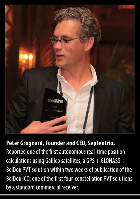
Peter Grognard
CEO | Septentrio Satellite Navigation
“In the next couple of years, the world’s community of GNSS users will enjoy many new exciting technical improvements and commercial possibilities. Septentrio is convinced that it is crucial for the success of the GNSS industry to enable early use of those new capabilities. Septentrio has a legacy of introducing receivers for new signals, such as EGNOS, L2C, and of course, Galileo. We have just introduced the AsteRx receiver, the first commercial fully Galileo-capable OEM engine, and we are committed to launching new innovative all-signals-in GNSS products in the coming months and years.”
Ralph Garcia
Director of GPS and Navigation Systems (GNS) | Raytheon Space and Airborne Systems Division
“GNS applies its electronics-based technology to avionics, high anti-jam receivers and integrated GPS/INS (inertial guidance system) navigators for several high-profile weapon systems and military aircraft. The plan for 2006/2007 is to continue providing enabling solutions for platforms such as C-130 AMP, F-35 JSF, V-22 Osprey, AV8B Harrier, F/A-18 E/F, Standard Missile 3, Tactical Tomahawk, Paveway, Joint Standoff Weapon, and Miniature Air Launched Decoy. GNS is also developing advanced technology such as Miniature Navigation Demonstration and the next-generation Modern User Equipment.”
Joel Houlton
Vice President and General Manager, Missiles and Munitions | Honeywell Defense & Space
“Our military customers continually challenge us to build up a GPS navigation system’s immunity to jamming and denial techniques. We have a number of GPS anti-jam approaches, fielded and under development, that address increasing thresholds for jammer resistance. The interrelationship of GPS and inertial navigation system (INS) operation is migrating from loosely coupled to deeply integrated. Front-end GPS antenna techniques are evolving to a complete digital architecture. Chip-scale atomic clock development will provide state-of-the-art timing stability and increased jamming immunity. With the array of military platforms and missions, GPS navigation is not a ‘one solution fits all’ business model. As a GPS navigation integrator, we have the flexibility to provide anti-jam organically or use outside sources. New platform starts generally require integrated solutions. Fielded products benefit from GPS/INS upgrades or add-on anti-jam antenna solutions.”
Oscar Pozzobon
Technical Director, Satellite Navigation Systems | Qascom
Examining satnav and security applications, Pozzobon has an entrepreneurial approach more reminiscent of Silicon Valley than of Europe. His ideas may challenge export control guidelines and trigger policy debates as the lines blur between commercial security or interference rejection and military anti-jam. “The drivers in the civil GNSS security market will be safety of life, secure tracking, trusted positioning, and secure time applications. We expect the GNSS security market to follow the IT security market: as use of IT technologies grew, the number and sophistication of attacks increased at alarming rates. We anticipate a similar trend in GNSS security.” The company will develop GNSS receiver security, GNSS signal security simulation tools, and the continued evolution of middleware for trusted GPS tracking.
Per Ludvig Normark
Chief Technology Officer | NordNav
The first to introduce software-based satellite navigation at the commercial level, NordNav’s embedded software receiver uses host CPU to calculate position, saving space and processing power. “We are particularly excited about our contract with a Nordic mobile handset vendor to have the first software location-enabled mobile handset on the market before the end of 2006. We will then be well-positioned to expand in the Asian and North American markets.” NordNav also claims to be first to release a commercial receiver supporting the Galileo Open Service modulation; the Galileo Joint Undertaking tapped it to lead a pan-European consortium in 2006 to develop and release mobile safety applications based on Galileo.

Philip G. Mattos
Chief Engineer, GPS and Navigation | ST Microelectronics R&D Ltd.
“My 2006 goal is to see my ideas for high-sensitivity GPS, in personal research since about 2001 and in development at ST for the last two years, implemented in silicon and out into the field. This should bring to the high-quality market in cars and to the consumer market in handhelds a real indoor capability, rather than the limited lab or demo indoor operation of the past few years. My 2007 goal is to see those high-sensitivity products in volume, and then the Galileo designs working in the lab and starting to be designed into customer products as “Galileo-ready,” needing only software upgrade to work with the satellites as they launch. Working on Galileo study contracts from the late ’90s, before it had a name, seeing it come to fruition tracking a single satellite, then getting the first fix will be the culmination of a long and productive path.”
Marco Falcone
System Engineering Manager | Galileo Project Office | European Space Agency
“ESA’s absolute priority is to keep the schedule of the program on track to maintain user expectations and get into operations soon,” says Falcone. The agency will launch GIOVE-B, in the second half of 2006, to complete validation of critical payload technology in orbit, in particular the passive hydrogen maser frequency standard. Falcone will be responsible for critical design reviews of the main GIOVE-A and GIOVE-B subsystems in late 2006 and early 2007, leading to authorization to manufacture the operational system. He’ll help to ensure GNSS interoperability with GPS, in particular a common L1 signal for GPS III and Galileo and a GPS-to-Galileo time offset broadcast in the navigation message. And, he’ll participate in coordination efforts with GLONASS and QZSS.
Phil Kelton
GPS Military User Equipment Program Manager | Raytheon
“The future of military GPS is bright! Technology progress and government policy changes have provided opportunities to develop military GPS modernized receivers with improved performance, improved security and reduced cost. Cell phone, personal computer, and gaming console developments have pushed ASIC technology forward while government policy changes have allowed for contractor-developed integrated security solutions. The potential exists to achieve true force-enhancing status for military GPS though the proliferation of low-cost GPS MUE.”
Jon Ladd
President and CEO | NovAtel
Heading a Canadian company that has landed key contracts for reference receivers in national aviation ground networks in the United States, Japan, Europe, China, and India, Ladd has also guided NovAtel to a strong pole position in Galileo ground infrastructure — unique for a non-European company — and poised for future commercialization of Galileo technology. He plans “continued significant investment in core R&D innovation and integration — the combination of GPS with other satellite systems, as well as the integration of GNSS with other complementary technologies.” He cites the recent launch of the company’s next-generation OEMV family of receivers, capable of receiving multi-frequency, GPS and GLONASS as well as L-Band DGPS signals, as an example of what to expect.
Michael O’Connor
Chief Technology Officer | Novariant Inc. (formerly IntegriNautics Corp.)
With the dramatic increase in use of high-precision GNSS for machine guidance and control, new opportunities emerge every day in agriculture, mining, transportation, asset management, and government. Pseudolite-based GPS augmentation technologies are now commercially available, and improvements in quality and quantity of signals-in-space lie right around the corner. We look forward to meeting the needs of these growing markets, with hands-free steering and visual guidance of farm vehicles; sub-inch, hands-free steering of container-moving gantry cranes in ports and rail yards; and pseudolite-based GPS augmentation systems for open-pit mining.
Ronald Hatch
Director of Navigation Systems | NavCom Technology, Inc.
With availability of three frequencies in GPS and Galileo nearing, Hatch’s current research includes “exploring the recently patented concept of smoothing one refraction-corrected composite phase measurement with a second. By resolving the ambiguities across two of the frequency differences and then refraction-correcting the results, a noisy measurement is obtained with no cycle ambiguity. This composite phase measurement can be smoothed with a second refraction-corrected measurement constructed to minimize the noise. As the smoothing progresses, the resulting increasingly accurate, refraction-corrected, ambiguity-resolved, phase measurement should enable real-time kinematic (RTK) accuracies across large distances.”
Hiroaki Maeda
Engineering Manager, Satellite Navigation and Positioning Systems Division, NEC Toshiba Space Systems Ltd.
Maeda has key project responsibility for the Quasi-Zenith Satellite System (QZSS) over the Asia and Oceania region, envisaged chiefly as a GPS (and Galileo) augmentation providing a new integrated service, primarily for mobile land applications in Japan. He will help guide the system through its development phase in 2006–07, moving toward a first satellite launch in 2009. His research efforts also explore indoor navigation.
Jean-Luc Issler
Head of Transmission Techniques and Signal Processing CNES Toulouse Center Radio Frequency directorate Delegate to the Galileo Signal Task Force
Issler’s top priorities are navigation signal design and processing and advanced navigation receivers. He is involved in the development of several GNSS receivers for space and ground applications. He predicts a generalized use of GNSS for spacecraft navigation, timing, and applications such as GNSS radio-occultations for meteorology, and is convinced of the software nature of future navigation technologic cores. With colleagues, he developed a GIOVE signal-performance evaluation system including top-level signal samplers and digitizers. The French Space Agency team also developed a very flexible GNSS signal generator, using an innovative concept that will be reused onboard Galileo.
Marie Lage
Owner | Dynamic Analytical Solutions
Lage currently supports NavAir in their development of the U.S. Navy Unmanned Combat Aerial System (UCAS) program, leading the development of the Relative GPS-based landing system, which will provide the highly accurate navigation required for the autonomous landing of an unmanned vehicle the size of a tactical fighter, loaded with fuel and weapons, on a moving aircraft carrier. She also serves as chief engineer for the demonstration of Automated Aerial Refueling (AAR) for application to unmanned aerial vehicles (UAVs). The AAR program uses integrated GPS/INS with carrier phase ambiguity resolution to provide a precise navigation solution with the required integrity and continuity to support refueling operations.
Carlo des Dorides
Head of Concession Division | Galileo Joint Undertaking
“I see two quite dense years ahead for the Galileo Project. The challenge is now to have the concession contract in force — financial close — within 2007. Indeed the choice to deploy Galileo adopting a project financing structure, namely a 20-year public-private partnership/concession, implies a complex contract negotiation to provide for balanced risk allocation, with the final objective to deliver the best value-for-money solution for the public sector. Certainly the Galileo project will represent a breakthrough not only in technology but also on the contractual paradigm at stake, which might disclose new frontiers to satellite programs and their exploitation objectives.”
Winston Guillory
Senior Vice President of Consumer & Business Sales | NAVTEQ
A global provider of digital map data for location-based services (LBS) and vehicle navigation, NAVTEQ powers more than 60 million sets of driving instructions per day. Guillory launched the NAVTEQ Global LBS Challenge (www.LBSChallenge.com) for application developers in 2004, at a time when many doubted the real potential of the long-forecast but slow-developing market. The Challenge has elicited several promising new applications entering the market today. Guillory plans to inaugurate an LBS Developers Conference this fall, following up with further programs and map content to drive the value chains’ continued momentum.
Christopher J. Hegarty
Director for Spectrum Management | Center for Advanced Aviation System Development | The MITRE Corporation
Co-editor of the second edition of standard reference text GPS Principles and Applications and a leading technical contributor to GPS and the Wide-Area Augmentation System (WAAS) in aviation, Hegarty will relinquish his role as editor since 1997 of NAVIGATION: Journal of The Institute of Navigation. He serves the Radio Technical Commission for Aeronautics (RTCA) as co-chair of Special Committee 159, Global Positioning System. “I expect to remain active advising the U.S. government on GPS and satellite-based augmentation system (SBAS) modernization, as well as the compatibility and interoperability of GPS with foreign systems including Galileo and GLONASS.”


