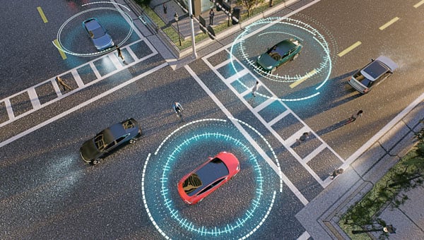
GNSS technology has had a reputation for unreliability in safety-critical applications, such as advanced driver assistance systems (ADAS). This perception has shaped automotive design and manufacturing: some ADAS developers have avoided GNSS altogether, instead relying on cameras, lidar and other sensors. Here, Manuel Del Castillo, VP of business development at Focal Point Positioning, explains how, with the right reliability, GNSS can offer a powerful layer of redundancy and support these other sensor types.
The hesitation to include GNSS in ADAS stacks is historical. Traditionally, this technology was unreliable, especially in dense, urban environments where satellite signals were obstructed. Consequently, many automakers turned to alternative sensors. For example, cameras can identify lane markings, traffic signs and objects, while lidar can build highly detailed 3D maps of the vehicle’s surroundings.
Each of these sensors provides important navigational data. However, they all describe a car’s location relative to its immediate environment. With no reliable source of absolute positioning, these relative measurements can’t confirm the vehicle’s exact place in the world — information that is critical for safe navigation.
Why ADAS Needs GNSS
Cameras, lidar and other sensors provide rich environmental data. However, they are limited by what they can directly observe. A camera can identify lane markings but can’t confirm which road the vehicle is on when multiple lanes or junctions overlap. Similarly, lidar can map obstacles in 3D, but without a wider frame of reference, it will struggle to anchor that map to the road network. HD maps provide another valuable layer, but without an accurate global position, they too can be misaligned with the real world, limiting their value.
GNSS can help plug this gap. By supplying absolute latitude and longitude, it ensures that the relative information from the other sensors is grounded in the correct location. GNSS helps calibrate and initialise other sensors, while also providing a cross-check against their measurements to detect potential errors or drift in sensor performance over time. Therefore, reliable GNSS is not an alternative to cameras, lidar or radar. It complements these sensors and boosts accuracy and the reliability of the overall system.
The Importance of Redundancy
Increasingly, the importance of GNSS in ADAS stacks is being recognised. As automotive production moves toward L3 automation and beyond, the demand for absolute positioning increases, along with the need for safe, layered sensing. GNSS, alongside cameras, lidar and radar, can help automakers improve navigational resilience without reinventing vehicular architectures.
Reliable GNSS isn’t about replacing other technologies. It is about reinforcing them. Having a global frame of reference helps ensure that the relative data from other sensors is grounded in the correct place. For automakers, the next step is recognising that GNSS can improve safety and trust in ADAS stacks, supporting the transition toward autonomous driving.
Advancing GNSS Reliability
Even with GNSS integrated into the vehicle’s sensors, challenges remain. Urban canyons and dense foliage can attenuate or even block satellite signals and create reflections, reducing accuracy. Since ADAS systems need reliably accurate absolute positioning, these challenges need to be addressed if we want GNSS to play a role in ADAS.
Newer, more sophisticated GNSS solutions are needed. The progression to Level 3 does not require an entirely new technology stack but rather extracting the very best from each of the existing components. For GNSS, this evolution involves implementing software-based solutions to achieve the necessary reliability improvements without overhauling hardware components. Pursuing cost-effective upgrades enhances performance without necessitating complete system redesigns, thereby keeping costs under control.
FocalPoint’s S-GNSS Auto software enhances GNSS accuracy in autonomous vehicles, providing reliable, absolute location to improve overall ADAS safety and efficiency. By boosting line-of-sight signals and rejecting non-line-of-sight signals, this simple firmware upgrade can help vehicles maintain accuracy in challenging environments.
By reducing positional uncertainty, these enhanced GNSS solutions strengthen the overall sensor stack. Together, these layers improve resilience, safety, and confidence in higher levels of vehicle automation.
As the automotive industry moves further towards L3 automation and beyond, reliable data on absolute position will be essential and will only reinforce the insights captured by cameras, lidar and other sensors.
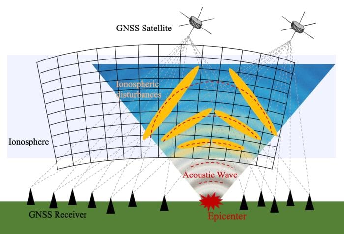
Scientists at Japan’s Nagoya University have used Japan’s extensive network of GNSS receivers to create the first 3D images of atmospheric disturbances caused by the 2024 Noto Peninsula Earthquake. Their results show sound wave disturbance patterns in unique 3D detail and provide new insights into how earthquakes generate these waves.
Japan has one of the densest GNSS networks in the world, with more than 4,500 receivers spread across the country. The network helps with precise location tracking and can also detect changes in the ionosphere.
A research team led by Dr. Weizheng Fu and Professor Yuichi Otsuka from Nagoya University’s Institute for Space-Earth Environmental Research (ISEE) has captured the detailed 3D structure of electron density changes in the ionosphere after the 7.5 magnitude Noto Peninsula Earthquake that occurred on January 1, 2024, in Ishikawa Prefecture, Japan.
When satellite signals travel through the ionosphere, they slow down because the radio waves interact with electrically charged particles. By measuring how much the signals slow down, scientists can calculate how many electrons are in the signals’ path and map the total electron content. Mapping these electrons allows them to effectively probe and monitor the state of the ionosphere.
About 10 minutes after the earthquake, the sound waves it generated traveled upward through the atmosphere and reached the ionosphere (60-1000 km above Earth). This created ripple disturbances similar to throwing a stone in a pond.
To build a 3D model of wave patterns, the researchers used a technique called “tomography” — similar to how CT scans create 3D images of the human body. They collected data on electron numbers from thousands of receivers tracking signals from satellites at different angles. By tracking their 3D models at different times after the earthquake, they created a time series of how electron density changed.
Sound waves generated from entire fault lines, not single points
South of the epicenter, the researchers observed a tilted sound wave pattern that gradually became more vertical over time. When an earthquake creates sound waves that travel upward through the atmosphere, the upper parts of the waves move faster than the lower parts. This makes the wave front lean or tilt as it moves. Over time, the tilted pattern gradually straightens into a more vertical alignment.
The researchers produced the first detailed 3D visualization of how the tilt angle changes over time during a seismic event. They tracked how the tilted wave patterns gradually straightened in unprecedented detail.
Earthquakes do not create atmospheric waves from just one spot, but rather from multiple points along the entire fault as different sections rupture over time. This explains why the atmospheric disturbances observed, such as tilted waves, were more complex than previous simpler models had predicted.
Previous models assumed all sound waves came from a single point at the earthquake’s center. While this matched some of their observations, it could not explain the complex, uneven wave patterns they saw in their 3D images.
To understand this, they included data from multiple wave sources along the fault line in their model, assuming that some parts of the fault generated waves about 30 seconds after the initial rupture. The results better matched their real-world observations and showed that earthquakes do not create atmospheric waves from just one spot, but rather from multiple points along the entire fault as different sections rupture over time. This explains why the atmospheric disturbances observed, such as tilted waves, were more complex than previous simpler models had predicted.
“By including multiple distributed sources and time delays, our improved modeling provides a more accurate representation of how these waves propagate through the upper atmosphere,” Professor Otsuka said.
“Disturbances in the ionosphere can interfere with satellite communications and location accuracy. If we understand these patterns better, we could improve our ability to protect sensitive technologies during and after earthquakes and enhance early warning systems for similar natural events,” lead author Weizheng Fu added.
Moving forward, the researchers are working on applying their model to other natural events such as volcanic eruptions, tsunamis, and severe weather events.
Read a roundup of recent products in the GNSS and inertial positioning industry from the March 2025 issue of GPS World magazine.
Surveying and Mapping
Photo: Eos Positioning Systems
New Eco-Friendly Carrying Case For Eos Positioning Systems’ receivers
The Skadi Gold, Skadi 300 and Skadi 200 GNSS receivers will now be shipped in a field-rugged carrying case made entirely from recycled materials. The case is designed to meet the demands of professionals who utilize GNSS technology in challenging environments. Its construction incorporates durable, eco-friendly materials that can withstand various field conditions, from remote wilderness areas to urban construction sites.
A key feature is its composition of 100% post-consumer recycled resin, which significantly reduces waste and promotes environmental sustainability, according to the company. It is specifically engineered to be shock-resistant and weatherproof.The case is provided as a standard inclusion with every purchase of the Skadi Gold, Skadi 300 or Skadi 200 GNSS receivers at no additional cost.
Multibeam Sonar Designed for bathymetric surveying
The Gemini 1200id is built on the same robust platform as the Gemini 720is multibeam sonar. The device features a 120° horizontal field of view, operating at both 720 kHz and 1,200 kHz acoustic frequencies.
The Gemini 1200id incorporates advanced noise reduction technology to significantly improve the attenuation of waterborne electrical noise to enhance imaging performance. An integrated speed-of-sound sensor ensures high positional accuracy of displayed targets, while CHIRP processing technology enhances target separation over extended ranges.
Compatibility with Tritech’s Genesis software package allows users to control multiple Tritech products from a single interface to streamline operations. The company has also made software development kits available for Windows and Linux operating systems to integrate into various platforms. The sonar’s design includes a custom-developed analog front-end solution with fully differential receiver channels, making it ideal for longer-range applications.
HiPer XRa is a GNSS receiver for surveying, mapping and construction applications. It can benefit a wide variety of users, including construction professionals, surveyors, geographic information systems (GIS) professionals, archeologists, engineering firms and more. The HiPer XR supports GPS, GLONASS, Galileo, BeiDou, IRNSS, QZSS and SBAS.
The new receiver has advanced Topcon Integrated Leveling Technology (TILT) compensation, featuring a calibration-free and magnetic interference-immune integrated IMU that provides up to 60° of tilt for precision measurements in challenging positions. It has signal integrity protection, anti-jamming and anti-spoofing capabilities. Through the myTopcon NOW! website, users can access online training materials, firmware updates and additional software resources.
Airborne Lidar System Ideal for coastline and river surveying
CoastalMapper is an airborne bathymetric lidar system for coastline and river surveying. The CoastalMapper can survey coastlines and rivers 250% faster than previous sensor models, according to Leica Geosystems.
It is suitable for various mapping applications, from assessing infrastructure resilience to monitoring river floods and conducting environmental investigations.
It features a high-performance bathymetric lidar module, a Leica TerrainMapper-3 topographic lidar and an imaging sensor, integrated into a compact and lightweight sensor head. This allows the CoastalMapper to capture up to 1 million bathymetric data points and 2 million topographic data points per second while providing high-resolution imagery with a 5-cm ground sampling distance at typical flying heights.
It integrates with Leica Geosystems’ airborne mapping workflows and offers cluster processing capabilities, allowing users to analyze large datasets and reduce the time from data collection to final deliverables. These outputs can include classified point clouds, digital terrain and surface models, and various imaging products.
Surveying Kit Streamlines base station and checkpoint setup
WingtraGROUND, a comprehensive survey kit, streamlines base station and checkpoint setup for on-site post-processing kinematic surveys with the WingtraONE Gen II, a vertical takeoff and landing UAV. The kit combines receivers, checkpoints and tools into a single, portable workflow.
The system integrates hardware components with a Wingtra tablet interface, which can help surveyors confirm correct receiver placement and avoid common errors associated with improper base station setup and inaccurate coordinates.
Wingtra receivers, equipped with Emlid Reach RS3 technology, provide accuracy within 2 cm, meeting high standards for aerial data validation. These receivers can also function independently for terrestrial surveys in real-time kinematic mode, including point collection and stakeout for various applications.
Galileo HAS-Enabled Receiver Offers positioning capabilities with 20 cm accuracy
The Geode GNS3H supports Galileo High Accuracy Service (HAS). It offers positioning capabilities with 20 cm accuracy worldwide without requiring additional infrastructure or subscriptions.
It is built to withstand tough conditions, making it ideal for demanding fieldwork. The device offers various accessories, including the Geode Grip, which combines the Geode with a data collection device of choice into a single handheld solution. A backpack strap kit and survey pole are also available to enhance mobility and flexibility in the field. The GNS3H can be used for surveying, agriculture, construction, forestry, mining and archaeology.
Expanded Mapping Portfolio 3D mapping technologies and more
Topcon Positioning Systems has become an authorized distributor of Pix4D’s photogrammetry software portfolio.
The partnership aims to enhance reality capture solutions across various industries, including surveying, mapping, utilities infrastructure, public safety, forensics, and architecture, engineering and construction.
The agreement streamlines the procurement process for end users by allowing them to access Pix4D’s advanced photogrammetry software solutions through Topcon’s global distribution network.
The GNSS real-time kinematic (RTK) 5 Click — a compact add-on board for high-precision positioning and navigation demands — features the UM980, an all-constellation multifrequency RTK positioning module from Unicore, with the advanced NebulasIV SoC for enhanced performance.
It supports Swift Navigation’s Skylark precise positioning service, multiple GNSS constellations and RTK positioning for centimeter-level accuracy. The board also features JamShield technology for robust performance in challenging environments, USB connectivity for easy configuration and visual status indicators for module status and GNSS signal reception.
It can be used for a variety of applications, including surveying and mapping, precision agriculture, UAVs, autonomous robots and autonomous driving.
Multi-Band GNSS Antenna Can operate in urban environments
Levity Series’ AHP24510 (L1/L2/L-Band) and AHP54510 (L1/L5/L-Band) directional patch antennas are designed to receive signals from GPS, Galileo, GLONASS and BeiDou satellite constellations.
These antennas offer faster and more accurate signal acquisition and lock, specifically in urban environments. The L-Band capability allows compatibility with high-precision GNSS correction services. The multi-band antennas offer integral redundancy to minimize satellite security blind spots and reduce energy consumption due to faster acquisition, requiring less system uptime to save power.
The Levity Series active antennas feature a 45 mm x 45 mm x 10 mm wide-band, dual-stacked patch design with a dual-feed, low noise amplifier, providing 28 dB to 29 dB gain and filtering. They operate with a maximum antenna VSWR of 1-to-1 from 1,207 MHz to 1,603 MHz, and the passive antenna efficiency ranges from 39.93% to 68.51% in the L1 band. These antennas use right-hand circular polarization to mitigate multi-path interference.
The Levity Series includes other multi-band products for high-precision applications, such as the HP24510A and HP54510A stacked-patch passive components, and the TFM.120A surface-mount front-end module, which covers the full multi-band GNSS spectrum including L-band. These antennas are suitable for various applications, including wearables, transportation, robotics, precision agriculture and autonomous vehicles.
The M9PLUS-HCT-A-SMA is an active multi-frequency GNSS antenna designed for high-accuracy applications. It supports L1/L2/L5 GPS, Galileo, Beidou and GLONASS bands, as well as L-band correction services. The antenna utilizes Maxtena’s proprietary Helicore technology, which offers advanced pattern control, polarization purity and efficiency in a compact form factor.
It integrates a pre-filter specifically engineered to mitigate LTE interference. This is crucial for maintaining signal integrity in environments with dense mobile communication networks, where LTE signals can overlap with GNSS frequencies. The pre-filter can effectively block out-of-band LTE signals, reducing intermodulation risks and ensuring clear GNSS signal reception.
The M9PLUS-HCT-A-SMA is built with rugged, IP67 automotive-grade components and includes an integrated SMA connector. It also features an O-ring for enhanced environmental sealing. Weighing only 24 grams, the antenna is ground plane-independent, making it versatile for various installations. It is particularly well-suited for GIS and RTK applications where high accuracy and reliability are crucial.
The MostaTech G321M is a three-axis fiber optic gyroscope (FOG) that offers high-precision navigation and orientation measurement capabilities. This advanced sensor features a data rate of 8 kHz.
Key features of the G321M include an input range of 400° per second, a bias RMS of 1° per hour and an angular random walk of 0.025 °/√h. Additionally, it has a power consumption of 2 W and an initialization time of 1 second. The G321M is designed with a compact form factor, making it suitable for various applications where size and weight are critical factors.
It is ideal for UAVs, robotics, borehole surveys, image stabilization, gimbal stabilization and underwater vehicles.
High-Precision Lidar Designed for precision applications
The TV1 Lite and the TV1 UAV systems are designed for various precision applications, such as mapping and data collection.
The TV1 Lite features TrueNav technology, a Hesai 32-channel laser scanner and a FLIR 5MP global shutter camera with a 90° field of view. It also includes one year of TV1 Lite Annual Processing with support and maintenance.
TV1 offers customization options, allowing users to choose from 26 MP, 45 MP or 61 MP cameras and various Trajectory Correction Service options.
Flight Control System With autopilot functionality
The Prism Supervisor software combines UAV autopilot flight control systems with AI-based observations processed in real time, aiming to enhance UAV operations.
The system provides a programming framework and software development kit for users to create custom mission scenarios. During flight, Prism Supervisor can adapt its autopilot functionality in real time, generating mission segments and flight plans as needed.
The software features a user-friendly graphic interface for mission planning, real-time visualization and execution. It supports Windows, Linux, macOS, iOS and Android.
Remote ID Receiver Enhances airspace awareness and UAV safety
RIDER is designed to enhance situational awareness by providing real-time detection of UAV activity in sensitive areas. It also seeks to provide a clear visibility of surrounding UAV operations to help avoid potential collisions and ensure safer flight experiences.
The device features a built-in industrial chip SIM that provides global coverage through LTE-M and NB-IoT, ensuring connectivity in various environments.
It operates effectively within a temperature range of -20 °C to +60 °C and is rated IP54 for dust and water resistance. The device complies with ASTM F3411-22A and ASD-STAN EN 4709-002 standards, making it suitable for regulatory environments.
The RIDER can detect signals from up to 5 km with its default antennas and up to 10 km when using an optional high-performance antenna. It is equipped with an internal cellular and Bluetooth antenna, along with an integrated GNSS antenna that provides precise positioning and timestamping capabilities. It supports multiple GNSS frequencies and utilizes Bluetooth and Wi-Fi technologies for Remote ID communications.
Streamlined BVLOS Operations For a variety of applications
The Sentaero 6 UAV is designed for advanced over-the-horizon operations beyond visual line of sight (OTH-BVLOS). It features built-in AI and machine learning capabilities for real-time data processing. The system can be used for surveying, mapping, inspection, asset monitoring and more.
Engineered to streamline operations, the Sentaero 6 offers more accurate and up-to-date intelligence on assets. Its onboard computer can processes data mid-flight.
Future developments will include swarm operations, enabling one human to control multiple UAVs simultaneously; fully remote operations and higher safety standards, such as a parachute for urban missions, according to Censys Technologies.
SBG Systems has significantly updated its Ellipse series sensors, incorporating the latest World Magnetic Model (WMM) to enhance accuracy and reliability in navigation applications. This upgrade is available for all Ellipse sensors, including first-generation models.
Designed for unmanned systems such as UAVs, UGVs and marine platforms, the Ellipse series comprises compact, high-precision inertial sensors. These devices feature built-in three-axis magnetometers that measure Earth’s magnetic field, crucial for accurate heading and positioning data.
Updated every five years, the WMM is a globally recognized mathematical representation of Earth’s magnetic field. The latest version, released in December 2024, ensures precise heading and positioning corrections to account for ongoing geomagnetic changes.
NDAA-Compliant UAV Now integrated with ArcGIS Flight
Esri now supports the Astro Max UAV in its ArcGIS Flight application. The Astro Max is the first Blue UAS-cleared and NDAA-compliant UAV to integrate with Esri’s platform.
The Astro Max, developed by Esri partner Freefly Systems, adheres to the security and performance standards set by the National Defense Authorization Act and the Defense Innovation Unit’s Blue UAS initiative. This industrial UAV is designed to enhance the capabilities of government and enterprise users utilizing ArcGIS Flight.
Autonomous Swarm Control Controls various autonomous platforms
The Autonomous Multi-Domain Operations Resiliency Platform for Heterogeneous Unmanned Swarms (AMORPHOUS) software features a single-user interface to operate thousands of autonomous assets simultaneously. Designed with an open architecture, this software enables the U.S. and allied militaries to control a mix of uncrewed platforms, payloads and systems.
AMORPHOUS includes an intuitive and distributed command-and-control interface to give operators the flexibility to conduct a wider array of intricate military missions. This collaborative autonomy at scale will provide warfighters with a decisive overmatch capability.
L3Harris is developing prototypes using the AMORPHOUS architecture on contracts for the U.S. Army and the Defense Innovation Unit. AMORPHOUS has demonstrated flexibility and interoperability by controlling multiple, separate assets across multiple vehicle types operating in different domains during government-managed tests.
AMORPHOUS supports decentralized decision-making, which enables individual, uncrewed assets to perform tasks autonomously and make real-time tactical decisions inside the network.
Advanced Counter-UAV Radar Multi-console radar control and display system
Cambridge Pixel has developed a radar control and display system for Weibel Scientific’s XENTA surveillance radar, which is designed for modern air defense and counter-unmanned aerial systems (C-UAS) applications.
The XENTA radar includes 3D target tracking, continuous target illumination and synthetic receiver beamforming. It is available in two configurations: the XENTA-M for short-range air defense and the XENTA-C for C-UAS operations.
The system is designed to work seamlessly with third-party command-and-control systems, enhancing operational efficiency.
Cambridge Pixel’s library of radar processing software allows users to develop a tailored radar controller specific to the XENTA radar’s requirements. Enhancements were made to existing functionalities, such as improved MIL-STD-2525 overlay graphics and support for dual-redundant operator consoles.
The XENTA radar system can detect small UAVs at distances exceeding 7 km and classify them beyond 5 km. This capability makes it suitable for various applications, including airport security, border control, critical infrastructure protection and event security.
The Pelican 2 agricultural spray UAV has an expanded 300-liter payload capacity and can cover up to 5.3 ha/hr.
It incorporates several technological enhancements designed to meet the demands of agriculture applications. The aircraft features an upgraded four-motor electric propulsion system, a wider 18-m spray swath and advanced lidar and radar systems for fully autonomous day-and-night spraying. These improvements aim to increase efficiency and precision in aerial application while reducing operational costs for farmers.
The Pelican 2’s airframe and structural components are constructed from carbon fiber composites, corrosion-resistant metallic components and 3D-printed assemblies.
“Seen & Heard” is a monthly feature of GPS World magazine, traveling the world to capture interesting and unusual news stories involving the GNSS/PNT industry.
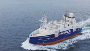
Autonomous vessel completes sea trials in Norway
Photo: Kongsberg Maritime
The Reach Remote 1, an uncrewed surface vessel developed by Reach Subsea in partnership with Kongsberg Maritime and Massterly, has been officially delivered after extensive sea trials overseen by Det Norske Veritas and the Norwegian Maritime Authority. This 24 m vessel is equipped with advanced hull-mounted survey sensors and a Work Class Electric ROV, designed to enhance subsea operations by improving efficiency, safety and environmental sustainability.
ESA in search of very low-Earth orbit technologies
Photo: VLEO
The European Space Agency (ESA) is seeking innovative space application ideas for very low-Earth orbit (VLEO), an orbital region between 100 km and 450 km. This initiative aims to explore new frontiers in space technology by soliciting creative solutions from researchers and innovators. ESA said VLEO presents several advantages, including reduced launch costs, enhanced Earth observation capabilities and a more harmless radiation environment. ESA is particularly interested in proposals addressing technological challenges specific to this orbital regime, such as atmospheric drag mitigation, advanced propulsion techniques and specialized satellite designs.
Car tracking leads to successful arrest
Photo: StarChase
The Pinole, Calif., Police Department utilized the StarChase GPS-based tracking system to safely apprehend suspects in a stolen vehicle. Instead of engaging in a dangerous high-speed chase, officers launched a GPS-enabled tracker that stuck to the vehicle, offering real-time location tracking. The Pinhole Police Department told The Richmond Standard, “This operation highlights how technology and collaboration keep our community safe — by reducing the dangers of high-speed pursuits while ensuring accountability and swift action.”
3D mapping of New Zealand coastline
Photo: nazar_ab / E+ / Getty Images
New Zealand has launched a coastal mapping project to help communities understand and mitigate climate change impacts. Led by Toitū Te Whenua Land Information New Zealand, the initiative will use lidar technology to create detailed 3D maps of up to 40% of the country’s coastline throughout three years. The $30.2 million project involves mapping 4,780 square km of coastal and seafloor terrain using specially equipped planes with high-resolution scanning equipment. Two suppliers, Woolpert NZ and NV5 Geospatial, will conduct the mapping across the North and South Islands, beginning in regions such as the Bay of Plenty and Invercargill.
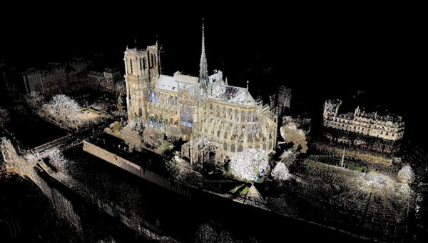
3D model of the Notre Dame Cathedral. (Image: Andrew Tallon/Vassar College)
Notre Dame Cathedral in Paris has reopened its doors five years after the devastating fire, showcasing its restored interior after extensive rebuilding work. The restoration, costing approximately €700 million ($737 million), was financed entirely by donations from around the world.
On April 15, 2019, Notre Dame went up in flames, with the spire collapsing and the roof being destroyed. The following years were dedicated to rebuilding the cathedral, including the reconstruction of the spire and the restoration of stained glass and woodwork.
A crucial element in the restoration process was the point cloud data collected by professor Andrew Tallon, an architectural historian from Vassar College, in 2010. Tallon’s project, which aimed to fully understand the Gothic structure and identify structural anomalies, involved creating a precise 3D model of Notre Dame using a Leica Geosystems terrestrial laser scanner.
This cloud of 1 billion points proved indispensable for the digital recreation of the cathedral’s interior and exterior. Tallon’s laser scans were the only truly accurate as-built measurements of Notre Dame, translating point clouds into detailed representations of its buttresses, ribbed vaults, stained glass, ornate carvings and other architectural details.
The value of point cloud data
While modern restoration efforts cannot fully replicate the artistry of centuries past, Tallon’s scans have been instrumental in reconstructing the Gothic cathedral, allowing architects to come remarkably close. Although Tallon died in 2018, his groundbreaking work remained a vital resource for restoring the iconic cathedral.
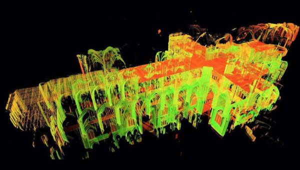
A point-cloud scan taken from Andrew Tallon’s scans of the Notre Dame Cathedral. (Photo: courtesy of Vassar University)
Tallon’s meticulous 3D scans of Notre Dame provided architects with information crucial for the cathedral’s reconstruction, including:
Precise 3D models: Tallon’s precise 3D model of Notre Dame included intricate details of the cathedral’s architecture, such as flying buttresses, rib vaults, stained glass windows and ornate carvings. This level of detail was unmatched by any historical drawings or records, which often lacked precision.
Dimensional and formal reconstruction: Pascal Prunet, one of the architects tasked with rebuilding the cathedral, said in an interview with Lindsay S. Cook that the point cloud data provided an “exact trace” of the cathedral’s state at the time of scanning, allowing him and his team to reconstruct elements — such as the vaults — “without hesitation” regarding dimensions or forms. This was essential for accurately rebuilding complex structures such as flying buttresses and rib vaults.
Structural analysis: The scans revealed structural details that were previously unknown, aiding in understanding how the cathedral was originally constructed and how it changed over time. This information was vital for designing custom supports and ensuring structural stability during reconstruction.
Integration with modern technology: The point cloud data was integrated into Building Information Modeling (BIM) processes, which allowed architects to create a digital twin of Notre Dame.
Restoration guidance: The scans provided a highly detailed record of Notre Dame’s pre-fire condition, which helped restoration professionals select appropriate techniques for stabilizing and rebuilding various parts of the cathedral.
Why precision matters
The two architects highlighted the crucial role Tallon’s laser scan of the cathedral played in their restoration process. They shared how this detailed digital model provided them with precise measurements and structural information, enabling Notre Dame to, in essence, “guide its own restoration.” By relying on this accurate data, the team could ensure its work remained faithful to the iconic cathedral’s original design and construction.
Tallon’s laser scan of Notre Dame Cathedral has proven invaluable in the restoration process. This digital twin, created in 2015, offers an unparalleled level of precision and detail, capturing the cathedral’s every nuance with accuracy up to 5 mm. This level of detail allows the restoration team to address the structure’s complexities and make informed decisions about the rebuilding process, ultimately helping to preserve Notre Dame’s authenticity and historical integrity.
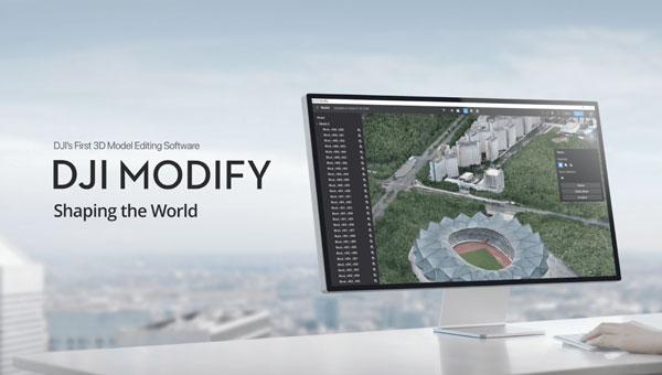
DJI has launched DJI Modify, its first intelligent 3D model editing software.
The solution can be integrated seamlessly with DJI’s enterprise UAVs and 3D modeling and mapping software, DJI Terra. When integrated with these products, the software can be used for aerial surveying, transportation and emergency responses.
Seamless workflow with DJI Terra
DJI Modify paired with DJI Terra offers users an end-to-end solution from modeling to model editing. Once DJI Modify has been enabled, DJI Terra files for model editing are automatically generated, including pre-identified objects and pre-processing of the model. It is designed to make repairing common 3D model defects seamless and efficient. As of early 2024, DJI Modify will only support repairing models built by DJI Terra.
Efficient 3D model editing
DJI Modify allows for model files to be quickly imported and exported to the DJI Terra and other third-party software. In the future, processed models can be shared to the cloud for online viewing and sharing via links without software installation, DJI said.
DJI Modify’s intelligent auto-repair editing supports flattening, editing textures, repairing water surfaces, removing floating parts, and filling holes. Edits can be made using one-click repairs or manually by selecting custom polygons, areas or meshes.
The software’s smoother model display technology allows high- and low-quality models to be viewed and edited in a single interface. Changes made can be synchronized across both models and previewed immediately, which allows users to address model editing issues in real-time.
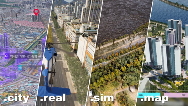
Techtree Innovation has launched AROUND, a high-precision, high-resolution 3D geospatial map platform designed to improve the quality and accuracy of existing 3D maps.
According to the company, AROUND is based on its existing 3D map generation and rendering technology. It offers four solutions for various industrial applications, such as urban or smart city planning, simulation, military and disaster management.
AROUND intends to provide high-precision, high-resolution 3D geospatial maps rendered with satellite maps, GIS data, 3D scanning using the photogrammetry software mapping (PSM) method, and high-end graphic production technology using the Unreal Engine, a 3D rendering platform.
The mapping platform aims to increase realism by implementing various visual geospatial information data — including terrain, buildings, vegetation, roads, transmission towers, traffic lights, signs and signboards, weather conditions, sunlight, coordinate data, elevation differences, and more from the real world. It is characterized by having accuracy and resolution within 5 cm and unifying all high and low altitude resolutions.
AROUND can be used for digital twins, smart city construction, autonomous driving, aviation, military training and education, disaster prediction, smart city or urban planning, review, architecture, design and more.
Image: Techtree
The platform offers four geospatial 3D map solutions tailored to users’ individual needs:
AROUND.city
AROUND.city is a solution that simulates the construction and development of urban areas or buildings. Through city simulation, 3D visualization, and data, AROUND.city can be used for analysis of various environments such as commercial, cultural, and residential facilities, and for space, environment, planning, design, and landscaping. The platform is designed to aid in the establishment and exploration of alternative plans, progress of development and evaluation in urban planning.
AROUND.real
AROUND.real provides high-quality 3D visualization mapping data with all collisions and blocks placed, which can be used in simulators of aircraft such as urban air mobility (UAM), helicopters, airplanes, autonomous cars, and various transportation means based on the development platform.
Using digital twins, AROUND.real allows for safe testing in risky real boarding and training areas. It also implements a variety of accurate and detailed visual-spatial information data, such as real terrain and buildings, grass, roads, utility poles, traffic lights, signs and signboards, weather conditions, and sunlight.
Around.sim
AROUND.sim visualizes refined data on various environmental factors such as building wind, flood, and population density in a specific area using the high-precision, real-world terrain and structures provided by the AROUND platform. Through this, users can predict problems about complex future situations in the same environment as reality, derive insights, or propose solutions.
AROUND.map
AROUND.map is a 3D real-estate marketing solution that already has commercialization achievements in the construction and allotment market. It visually represents the vision and buildings of the future that do not exist at the time of pre-sale, addressing the disadvantages of the existing pre-sale market, and implements all visual expressions such as virtual tours of all surrounding locations and pre-sale complexes, traffic, development plans, development benefits, view rights, and sunlight rights, just like reality.
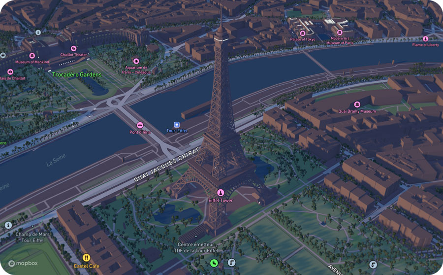
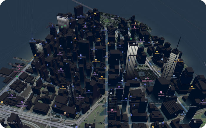
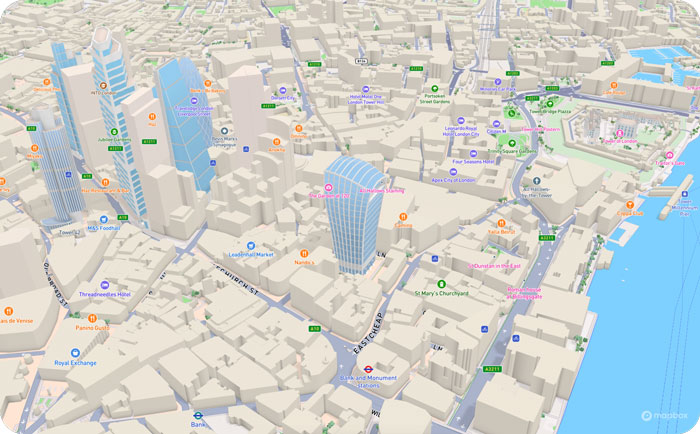
Mapbox, a maps and location platform, has released new platform updates to enhance user’s 3D mapping experience by adding powerful dynamic lighting capabilities and landmark 3D buildings.
The new ready-to-use platform aims to enhance wayfinding and spatial orientation for users and provides a polished canvas for custom location data. Mapbox Standard is now accessible in public preview and available in pre-releases of the latest versions of its web and mobile SDKs.
Dynamic lighting for a natural day to night shift
Mapbox Standard provides four lighting presets: day, night, dusk and dawn. As the sun moves throughout the day, based on a user’s location, shadows shift and highlight different areas of the map. The dynamic lighting creates a true-to-life experience that can help users better orient themselves in the physical world.
Image: Mapbox
Landmarks improve map comprehension in 3D
As part of Mapbox Standard, Mapbox has created a dataset of hundreds of recognizable landmarks across the globe, with more being added each month. The landmark buildings integrate seamlessly into the map environment and respond dynamically to lighting changes.
Therefore, our cartographers chose a sleek and beautiful symbolic realism design for Mapbox Standard design that offers users an easy-to-read map where elements such as landmarks, buildings, roads and trees are clearly identifiable while keeping icons, labels and custom location data elements visible.
Users can choose between the new 3D elements and the 2D map within their application. Mapbox Standard is built with a base map that evolves alongside custom layers, delivering up-to-date rendering features and data layers without a manual style update or version upgrade.
To explore the new Mapbox Standard style, click here.
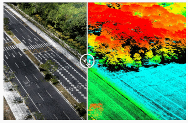
Cepton Inc. is working with LidarSwiss Solutions GmbH to deploy its lidar technology in a drone-based mapping and analytics solution for infrastructure management and engineering design applications.
Cepton is a Silicon Valley innovator of high-performance lidar solutions. LidarSwiss is a Switzerland-based provider of high-performance unmanned aerial vehicle (UAV) lidar solutions.
Utilizing Cepton’s Sora lidar sensor, the LidarSwiss Nano P60 system provides high-fidelity mapping and real-time processing on the fly to serve engineers, forestry managers and urban planners across the globe. To date, Nano P60 has been used to map and analyze powerlines, areas for site development, flood plains and highways in more than 20 cities in Asia, Europe and Australia.
Nano P60 packages Cepton’s Sora lidar, a 42-mp camera, an Applanix IMU/GNSS and a LidarSwiss controller. (Photo: LidarSwiss)
Nano P60 integrates Cepton’s Sora sensor with a high-precision IMU/GNSS unit from Applanix and high-resolution camera system. Its intelligent controller with LidarSwiss proprietary software automatically combines all raw data to generate high-density, high-precision RGB attributed 3D laser point clouds during flight.
With a total weight of 2.1 kg, this compact system can be mounted on small UAVs to produce mapping products such as digital orthophotos, digital elevation models and 3D models, or to interface with a third-party software to enable easy, seamless solutions for all kinds of industry applications, such as digital twins, smart cities and building information modeling (BIM).
“The prominent features of the Nano P60 are its high stability, point density and intelligence,” said Robert Kletzli, LidarSwiss founder and CTO. “This lidar-enabled system addresses the critical gap of 3D accuracy with traditional camera and stereo imaging technologies. Now, instead of needing two images to see a single point and detect its elevation, Nano P60 utilizes lidar’s intrinsic 3D imaging capabilities to achieve maximized efficiency, making real-time processing and analytics possible. Cepton’s Sora lidar is among the most compact, lightweight lidar sensors that we have tested and offers an unparalleled combination of high resolution, longer range in the same category and cost efficiency. Its unique lidar architecture allows seamless integration, making Nano P60 a true plug-and-play system with solid-state reliability.”
Nano P60 combines lidar point clouds with RGB imagery to generate high-density, high-precision 3D imaging with color by elevation features. (Image: LidarSwiss)
“We are proud to be supporting LidarSwiss and its customers with our lidar technology to unlock applications such as 3D modeling for BIM, historical site mapping, terrain modeling for heavy vegetation areas, volumetric calculations for mining, power line inspection and forestry mapping,” said Klaus Wagner, director of Product Management and Marketing at Cepton. “Our Sora lidar is a one-of-a-kind line scanner that combines high frame rate and long range. Powered by Cepton’s proprietary lidar technologies, it is compact, lightweight and rotation-free, making it ideal for small UAV applications.”
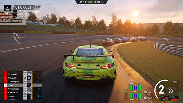
The realistic racetrack in the Assetto Corsa game. (Screenshot: Dronezone)
News from OxTS
The possible applications for 3D point clouds are almost endless. When you think of lidar, the mind naturally wanders to applications of the autonomous vehicle navigation or geospatial survey type. In fact, navigation and lidar data are useful for all manner of applications—including video game development.
When a new technology, such as lidar, is first brought to market, a number of factors affect its price. Initially, the cost-per-unit is likely to be high to ensure recovery of research and development costs. However, as technology ages and manufacturers innovate and bring out new versions, price invariably comes down.
As this process occurs, it puts the technology into the hands of a much wider audience, increasing the number of new and innovative use cases.
Point clouds are useful for many wide and varied applications. Autonomous vehicle developers may use point clouds to aid object detection and avoidance, while geospatial surveyors could use a point cloud to determine road degradation over time or monitor the rate of coastal erosion.
These are however some of the more common use cases. But how can navigation data be used in applications such as video game development? Let’s first look at how navigation data works alongside lidar.
Lidar and Inertial Navigation
To create a 3D point cloud, users must combine the position, navigation and timing measurements from an inertial navigation system (INS) with raw lidar data. Without accurate INS data, it is impossible to create a point cloud. This is because the lidar sensor needs to know its position in space and time and its orientation.
To avoid complicated software engineering work, simple-to-use software such as OxTS Georeferencer is available to georeference the lidar data. Once georeferencing is complete, OxTS Georeferencer will create a PCAP file that users can view in many point cloud viewer software applications.
Enter Dronezone
As lidar technology becomes more accessible, new and inventive ways to use point clouds are coming to light. OxTS partner Dronezone is one such company finding new uses for lidar.
Dronezone builds and hires out professional unmanned aerial vehicles (UAVs). They build UAV payloads with Velodyne VLP-16 lidar sensors and OxTS INS devices they sell or rent to customers.
Cover: Kunos Simulazioni
Dronezone’s customers have used the payloads for a variety of projects. One used a payload to scan an aging railway bridge looking for possible weaknesses and deterioration over time. Besides geospatial mapping projects, Dronezone is seeing an increasing need to cater to niche applications.
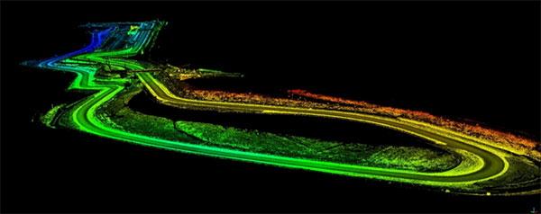
Dronezone undertook surveying the Transylvania Motor Ring racetrack for a video-game developer Kunos Simulazioni, which publishes racing simulator “Assetto Corsa.” The company wanted an accurate digital representation of the track contours. The results, which you can see in the video and screenshots, are particularly impressive.
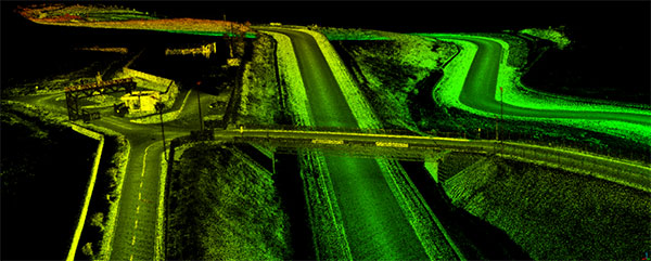
Point cloud of the Transylvania Motor Ring. (Image: Dronezone)
Point cloud of the Transylvania Motor Ring. (Image: Dronezone)
Racing Simulator
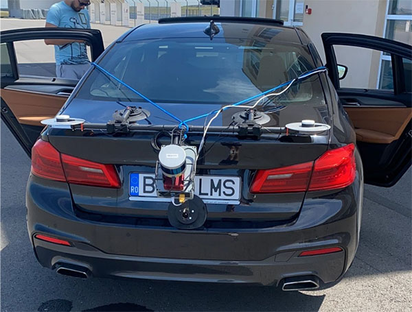
For this project, Dronezone moved away from traditional UAV-based mapping. To survey the track precisely, the company used the flexibility of its UAV payload by repurposing the hardware for use on a car. With many off-the-shelf solutions, this wouldn’t have been possible. The setup enabled Dronezone to complete multiple laps of the track and create a high-density point cloud.
“Using different components to build a UAV payload meant that Dronezone could reuse the hardware and build a different setup suitable for use on a car,” said Paris Austin, head of new product technology, OxTS. “It’s this flexibility that allows Dronezone to serve multiple applications.”
To further improve results, Dronezone used the Boresight Calibration feature within OxTS Georeferencer to calibrate the coordinate frames of the lidar sensor and INS. This process, which involves a short survey of two retro-reflective targets, increases the clarity of the final results and eliminates blurring and double vision.
The OxTS INS and lidar payload on an auto for racetrack mapping. (Photo: Dronezone)
The quality of the data produced has given Dronezone confidence it can win more business from the same customer to map further tracks for the game.
This is just one example of the new and unique applications we’re developing alongside our customers.
“Seen & Heard” is a monthly feature of GPS World magazine, traveling the world to capture interesting and unusual news stories involving the GNSS/PNT industry.
3D mapping is helping forensic teams reconstruct fatal traffic accidents in Singapore, reports The Straits Times. In 2021, Singapore had 100 fatal road accidents. Experts use 3D replicas of the accident site and simulation models to recreate events leading to an accident and its aftermath. This helps forensic scientists determine whether the vehicles were speeding or flouting traffic rules. The National 3D Mapping Program of the Singapore Land Authority has mapped every road, lane and highway in Singapore with a 3D laser scanner and car-mounted cameras, and plans to update the maps regularly. Autonomous vehicles will also depend on the 3D point-cloud data.
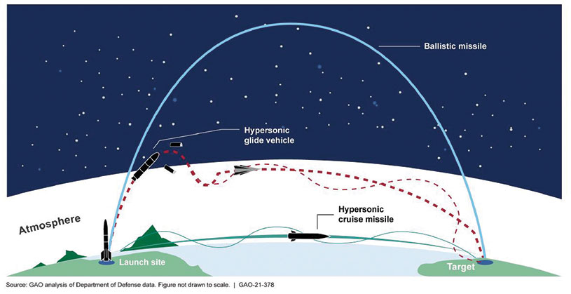
Diagram: U.S. General Accountability Office
BeiDou Enables Hypersonic Flight
In simulation drills using BeiDou, Chinese space scientists flew a hypersonic flight from Jinan, China, to New York over the Arctic Ocean, reports EurAsian Times. BeiDou facilitated contact between the command center on Earth and the hypersonic vehicle as it dodged enemy air defenses. Researchers claim using BeiDou provided a time lag of less than a second. They also claim to have optimized signal transmitters and designed new satellite-jumping methods to overcome communication challenges. China and Russia are the only countries with operational hypersonic weapons — Russia has used its Kinzhal hypersonic missile in the Ukraine war.
Indonesia’s National Research and Innovation Agency (BRIN) and Dr. Soetomo University are cooperating on aerial photo mapping using an unmanned aerial vehicle and GNSS hardware. BRIN’s Ocky Karna Radjasa said he expects that the two parties will extend the opportunity to advance research and innovation as well as bolster the quality of education in Indonesia. The university’s Nur Saidah expects BRIN’s support will increase, stating, “We still have limitation in laboratory facilities, so we seek industry cooperation. Let us hope that, as a result of this cooperation, we can receive help.”
A new navigation system addresses shortcomings of GNSS using cosmic-ray muons. Muometric navigation enables positioning underground, indoors or underwater within a reference coordinate system defined by the 3D positions of multiple detectors, researcher Hiroyuki K. M. Tanaka explains in the June issue of Nature. Tanaka’s work shows the system offers a navigation quality almost equivalent to aboveground GPS-based handheld navigation by determining the distance between the reference frame and the receivers with a precision of 1 to 10 meters.
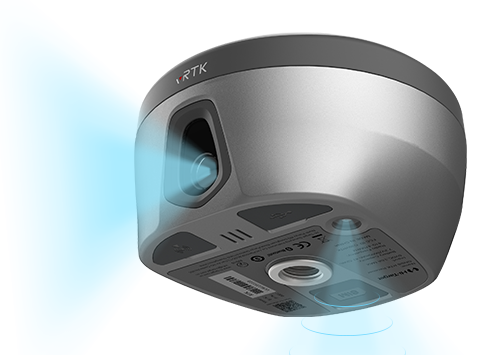
Hi-Target has launched a real-time-kinematic (RTK) GNSS receiver that has an eye for visual positioning.
The pocket-sized vRTK GNSS RTK System is equipped with professional dual cameras to enable non-contact image surveying. It also has an advanced inertial measurement unit (IMU).
vRTK is suitable for non-contact measurements in a variety of hazardous and complex environments. High-quality sensors ensure the stability of the receiver’s accuracy in working status. By combining imagery with high-precision positioning equipment, users benefit from the convenience of visual positioning technology, which allows them to obtain the location of the target with a touch of a finger from a distance.
The lightweight, innovative visual RTK receiver improves the speed of stakeout with its Live View Stakeout function. Non-contact measurement greatly improves the usable range of GNSS and efficient, safe operation, the company said, greatly improving the efficiency of surveyors and engineers.
vRTK Features
The vRTK receives 1,408 channels, including GPS, GLONASS, BeiDou, Galileo, QZSS, IRNSS and SBAS. A new generation of GNSS engine supports the new frequency points B1C, B2a and B2b RTK decoding of the Beidou-3 satellite. The introduction of multi-frequency anti-jamming technology and multi-step adaptive filtering technology features strong signal, high-quality data, fast fix and high accuracy.
The vRTK has a nine-axis IMU module with auto installation for tilt surveying. Users can easily pick it up and arrive at the target point to carry out the tilt survey with an error of less than 2.5 cm within a 60° inclination.
It is compatible with popular modeling software programs and can be used to collect point cloud and 3D modeling data in one step.
A case study describing development and use of the vRTK is available.