Mapbox and Hyundai AutoEver, a software affiliate of Hyundai Motor Group, have developed an integrated AI-driven 3D navigation system with advanced driver-assistance (ADAS) capabilities. This system, powered by Mapbox 3D Live Navigation and MapGPT, operates on Hyundai Mobis’ cockpit domain controller.
The Mapbox 3D Live Navigation system offers 3D lane-level guidance, augmented reality overlays and real-time driver assistance. It integrates Mapbox’s navigation technology with Hyundai AutoEver’s software-defined vehicle platform and Hyundai Mobis’ AR-enabled cockpit domain controller. This integration provides drivers with turn-by-turn navigation enhanced by ADAS alerts, including collision warnings and lane departure notifications.
MapGPT, an AI-powered location assistant, complements the navigation system. It facilitates voice-driven interactions for dynamic routing, real-time traffic updates and hyper-local search. The system also allows voice-activated controls for in-car functions such as climate control and music. For electric vehicles, MapGPT includes features such as real-time range monitoring and charging station recommendations.
At CES 2025, Mapbox and Hyundai AutoEver will demonstrate these technologies, showcasing features such as lane-level AR navigation, voice-controlled systems and electronic vehicle-specific tools.
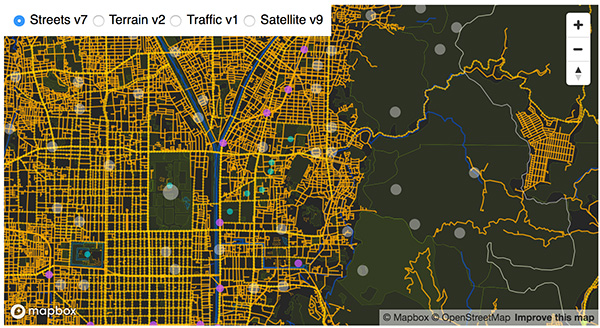
Mapbox, a maps and location platform, has released new platform updates to enhance user’s 3D mapping experience by adding powerful dynamic lighting capabilities and landmark 3D buildings.
The new ready-to-use platform aims to enhance wayfinding and spatial orientation for users and provides a polished canvas for custom location data. Mapbox Standard is now accessible in public preview and available in pre-releases of the latest versions of its web and mobile SDKs.
Dynamic lighting for a natural day to night shift
Mapbox Standard provides four lighting presets: day, night, dusk and dawn. As the sun moves throughout the day, based on a user’s location, shadows shift and highlight different areas of the map. The dynamic lighting creates a true-to-life experience that can help users better orient themselves in the physical world.
Image: Mapbox
Landmarks improve map comprehension in 3D
As part of Mapbox Standard, Mapbox has created a dataset of hundreds of recognizable landmarks across the globe, with more being added each month. The landmark buildings integrate seamlessly into the map environment and respond dynamically to lighting changes.
Therefore, our cartographers chose a sleek and beautiful symbolic realism design for Mapbox Standard design that offers users an easy-to-read map where elements such as landmarks, buildings, roads and trees are clearly identifiable while keeping icons, labels and custom location data elements visible.
Users can choose between the new 3D elements and the 2D map within their application. Mapbox Standard is built with a base map that evolves alongside custom layers, delivering up-to-date rendering features and data layers without a manual style update or version upgrade.
To explore the new Mapbox Standard style, click here.
Toyota and Lexus are now utilizing Mapbox‘s technology to deliver navigation features. Mapbox’s maps software development kit incorporates a map design that complements Toyota’s multimedia system, making turn-by-turn navigation intuitive for drivers.
With Mapbox’s navigation technology, Toyota can push updates to the design to vehicles in real time, so that the driver’s experience continues to be up to date. As more vehicles hit the road with the next-generation multimedia system, drivers of those vehicles will benefit from utilizing more engaging and robust navigation software that can be updated in a manner similar to updates on their smartphone.
Toyota’s designers are also able to modify the look and feel of the navigation experience via Mapbox Studio, enabling map design updates to be rolled out to all vehicles instantaneously.
A roundup of recent products in the GNSS and inertial positioning industry from the March 2023 issue of GPS World magazine.
UAV
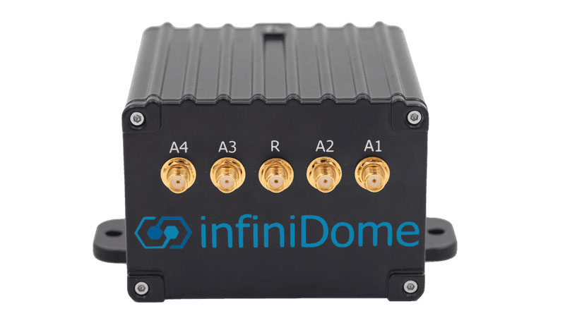
Image: InfiniDome
Anti-Jamming Device Provides protection from three directions of attack
The GPSdome 2 is tailored to defend small- to medium-sized tactical UAVs as well as manned and unmanned ground vehicles. With a small form factor (500 g, 87 mm x 91 mm x 61.55 mm) and minimal power consumption, GPSdome 2 is suitable for loitering munitions as well as UAVs. Fully retrofit and completely standalone, the system is compatible with almost any off-the-shelf GNSS receiver as well as standard active GNSS antennas, meaning that it can be integrated into existing GPS systems or into new product lines, manned or unmanned. With sophisticated algorithms and a proprietary RFIC, GPSdome 2 analyzes RF interference in the environment and combines multiple antenna patterns to create and dynamically steer three nulls in the direction of any hostile signal. GPSdome 2 provides simultaneous dual-frequency protection (GPS L1 + L2 or GPS L1 + GLONASS G1), creating up to three nulls, protecting from three jamming directions within each band in real time, making it suitable for PNT applications. The GPSdome 2 is a dual-use, non-ITAR device and comes with optional mil-spec compliance. InfiniDome, infinidome.com
Image: uAvionix
Command and Control Designed for easy integration
The SkyLine C2 management platform and muLTElink airborne radio systems (ARS) are designed to integrate, which enables a self-healing command-and-control network capable of both path and link diversity. This eliminates lost-link possibilities over broad terrain and altitude ranges. MuLTElink ARS consists of two models — muLTElink915 and muLTElink5060, the core of the uAvionix C2 system. The muLTElink915 model combines globally licensed aviation LTE, enhanced with frequency hopping 902 MHz – 928 MHz industrial, scientific and medical frequencies capability. The muLTElink5060 model combines global LTE with aviation-protected 5,030 MHz – 5,091 MHz C-band. Each muLTElink model allows up to one external CNPC radio to be optionally connected to allow simultaneous use of all three frequency ranges, higher power C-band operation or future radio integrations. uAvionix, uAvionix.com
Image: Atmos
VTOL UAV With Sony a7R mark III and IV camera
Atmos has integrated the Sony a7R mark III and IV cameras into its vertical take-off and landing (VTOL) fixed-wing UAV, the Marlyn Cobalt. This will increase coverage and accuracy achieved in a single flight for surveyors. Both cameras have an ISO of 32,000, which is expandable to 102,400, and camera sensors with high megapixel count — 42,4 MP for the a7R III and 61 MP for the a7R IV. When combined with Zeiss’ 35 mm and 21 mm lenses, it enables UAV surveyors to achieve ground sample distance levels below one 1 cm. The integration of the two cameras enables Marlyn Cobalt users to map an area of 210 ha with centimeter-level accuracy in a single flight. Atmos, atmosuav.com
Trueview 720. (Image: GeoCue)
TrueView 535. (Image: GeoCue)
Accuracy Star. (Image: GeoCue)
UAV and Lidar Systems Suitable for geospatial professionals
TrueView 535 consists of updated lidar sensors, adding a third return, increasing mapping abilities below canopy. An additional third nadir camera offers another point of view and improves photogrammetry quality. It also includes a longer, usable lidar range to increase flexibility. TrueView 720 is a fourth-generation Riegl VUX-120 with three laser beam orientations. It provides high-point density corridor mapping. Using the Riegl VUX-120 with three laser beam orientations (nadir, +10 degrees forward and –10 degrees backward) and three oblique/nadir cameras enables data collection from more surfaces in one flight path. One application of TrueView 720 is scanning power lines. Users can capture the poles vertically, front and back. The extreme range of this system means it can be integrated with UAVs, airplanes or helicopters. In addition to the two sensor payloads, GeoCue has launched its LP360 software add-on for processing and visualization — the 3D Accuracy and the Accuracy Star hardware.
GeoCue, geocue.com
OEM
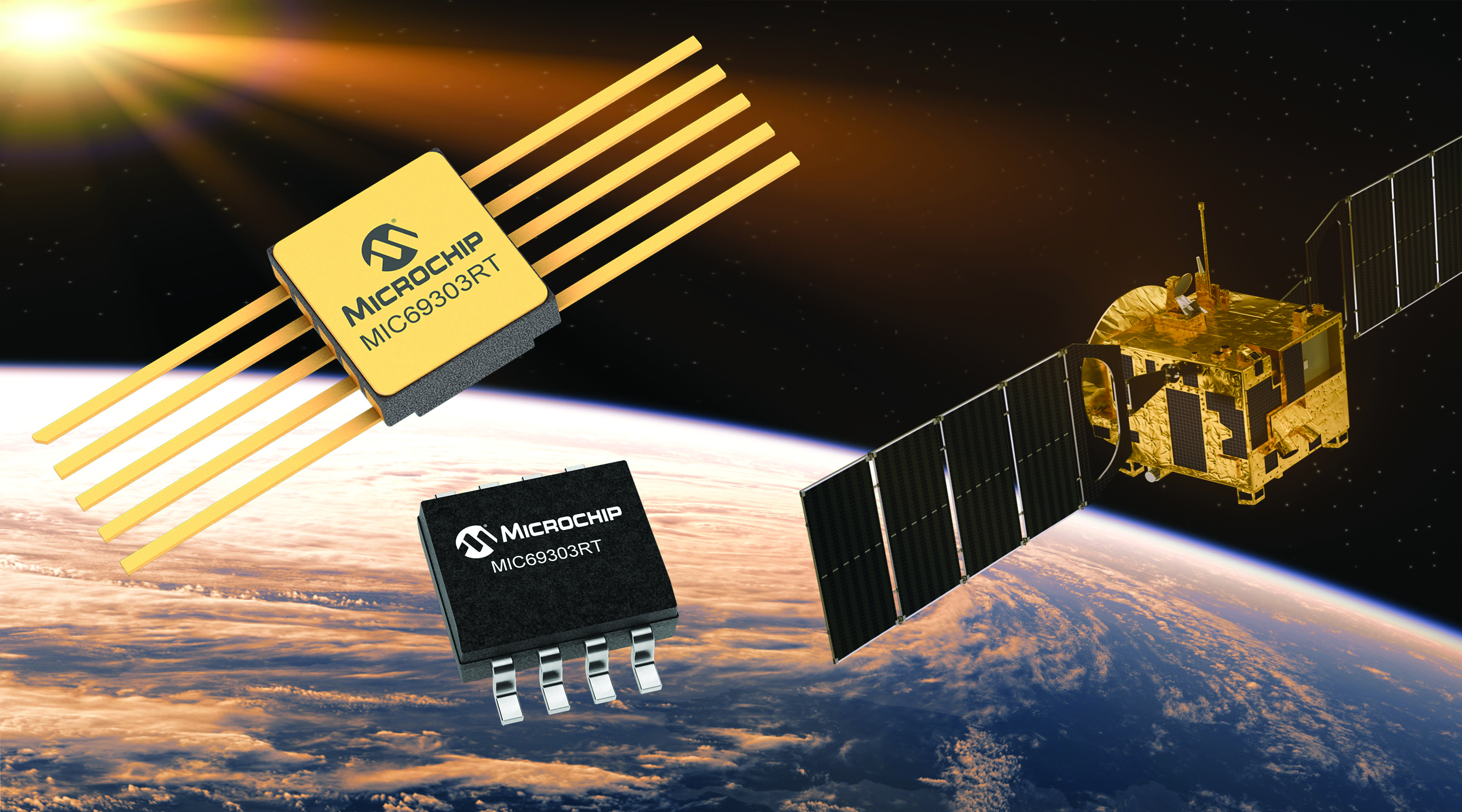
Image: Microchip
Voltage Regulator Device for LEO space application
The MIC69303RT is a radiation-tolerant power management device for space application developers. It is a high-current, low-voltage device targeting low-Earth orbit space applications. The MIC69303RT operates from a single low-voltage supply of 1.65 v to 5.5 v and can supply output voltages as low as 0.5 v at high currents. It offers high-precision and low dropout voltages of 500 mv under extreme conditions. The MIC69303RT is a companion power source solution for microcontrollers, such as the SAM71Q21RT and PolarFire field-programmable gate arrays. MIC69303RT is designed for harsh aerospace applications and remains operational in temperature ranges from -55 C to +125 C. Microchip Technology, microchip.com
Image: Spirent Communications
LEO Satellite Device Designed for GNSS/PNT lab testing
SimORBIT is a low-Earth-orbit (LEO) satellite solution software designed to aid developers in determining LEO orbits more accurately for GNSS/PNT lab testing. The software replicates LEO orbits so that simulations can provide the realistic environment of a LEO satellite, including gravitational and atmospheric impacts the satellite could encounter in space. Developers can create non-ICD signals via I/Q injection, or by the “Flex” feature, generating space-centered PNT signals to be developed in the lab as realistically as possible. Spirent Communications developed SimORBIT in partnership with SpacePNT. Spirent Communications, spirent.com
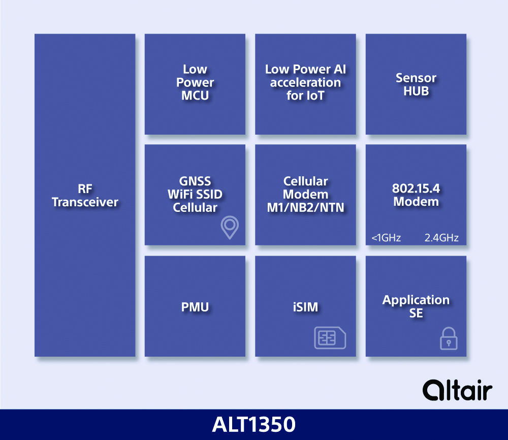
Image: Sony
5G Chipset Includes GNSS
The ALT1350 implements GNSS, cellular and Wi-Fi-based location in a single chipset. The cellular LTE-M/NB-IoT chipset is designed to enable additional low-power, wide-area (LPWA) communication protocols; intermittent LTE and GNSS (GPS/GLONASS) navigation for low-cost applications; and concurrent LTE and L1/L5 GNSS for tracking applications. The ALT1350 incorporates a sensor hub to collect data from the sensors while maintaining ultra-low power consumption. It also provides cellular and Wi-Fi-based positioning and is tightly integrated to provide power-optimized concurrent LTE and GNSS to accommodate various tracking applications, which can be demanding with a single chip. The chip is designed to enable deployments for the internet of things (IoT), including location technologies. Sony, altair.sony-semicon.com
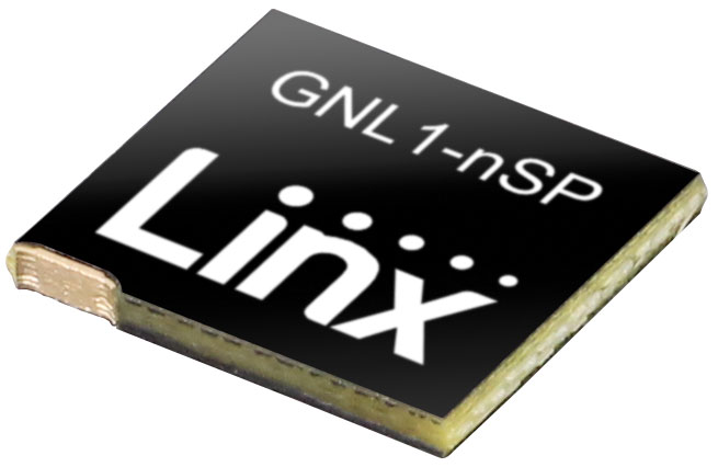
The ANT-GNL1-nSP is a surface-mount embedded GNSS antenna supporting GPS, Galileo, GLONASS, BeiDou and QZSS in the L1/E1/B1 bands. The ANT-GNL1-nSP antenna exhibits high performance in a compact size (10 mm x 8 mm x 1 mm) and features linear polarization and an omnidirectional radiation pattern. The antenna is available in tape and reel packaging and is designed for reflow-solder mounting directly to a printed circuit board for high-volume applications. Linx Technologies, linxtechnologies.com
Image: OriginGPS
GNSS Module Based on a MediaTek chipset
The ORG4600-MK01 dual-frequency module provides higher precision than the company’s previous modules. It has sub-1 m precision at a cost lower than that of the company’s first L1+L5 module, the ORG4600-B01, which is based on Broadcom’s chipset. The 10 mm x 10 mm ORG4600-MK01 was designed for applications deployed in challenging environmental conditions. The solution also includes RTCM, a logger and accurate orbit prediction. OriginGPS, origingps.com
MAPPING
Image: Mapbox
Navigation Software Includes enhancements to existing software and more
Navigation software development kit version 2.9 provides pre-built applications compatible with Android and IOS. SDK v2.9 provides the primary navigation components across a workflow using lines of code instead of starting from square one. The drop-in user interface is customizable to reflect a developer’s brand, obviating the need to manually develop a full end-to-end application. Navigation SDK Copilot — a backend analytics tool for CX on navigation applications — collects trace files of navigation sessions and search analytics data from users. Developers can use this data to gather feedback and collective user data to create touch points with users and improve application experience based on their data-drawn conclusions. Matrix API has been updated to support scheduled departure times and provide optimal driving routes, creating a more accurate estimated time of arrival. Mapbox, mapbox.com
Image: Hexagon
Defense Platform For developing Android applications
LuciadCPillar is designed for the development of mobile applications for dismounted soldiers in the field. Developers can build applications with 2D and 3D views. It features military symbology and supports many geospatial data types including vector data, raster data, elevation data, point clouds and 3D meshes. It has the same capabilities found in desktops, in-vehicle and browser applications built with LuciadLightspeed, LuciadCPillar and LuciadRIA. The platform offers capabilities to match high-resolution screens, graphic processing units and multi-core processors including the ability to display 3D data in mobile applications. LuciadCPillar supports ARM processors and an application programming interface, which aligns with the Android developer experience. Impact, a French system integrator, partnered with Hexagon to test LuciadCPillar and will integrate it into its Delta Suite product, which is used by the French Special Operations Command. LuciadCPillar is part of Luciad 2022.1, which is available now globally. Hexagon, hexagon.com
Image: Golden Software
Surface Mapping Designed for 3D surface mapping
The Surfer package is designed for 3D surface mapping and provides robust subsurface visualization and modeling functionality by incorporating many true 3D gridding and visualization tools. With the enhanced functionality, users can now model an additional variable, a C variable, such as a contaminant or chemical concentration, along with the traditional X, Y, Z values. Surfer also includes the ability to create a 2D map of a slice-through 3D grid, which users can move up and down through the grid, illustrating how the C value changes with depth. Part of Surfer’s enhancements is isosurface creation, enabling visualization of the 3D grid in the 3D view as an isosurface, providing another way to see how C data varies with depth or elevation. The new 3D-rendered volume functionality also allows users to visualize the 3D grid in the 3D view as a solid body by assigning colors to different C values, highlighting variations in the data. Golden Software, goldensoftware.com
Bikes have been used for centuries for transportation, exercise, and recreation. Now, thanks to developments in battery technology and growing environmental concerns, sales of e-bikes are exploding.
The Roundup has estimated that 300 million e-bikes will be used around the globe by next year, with annual sales reaching 10 million by 2024 and 17 million by 2030.
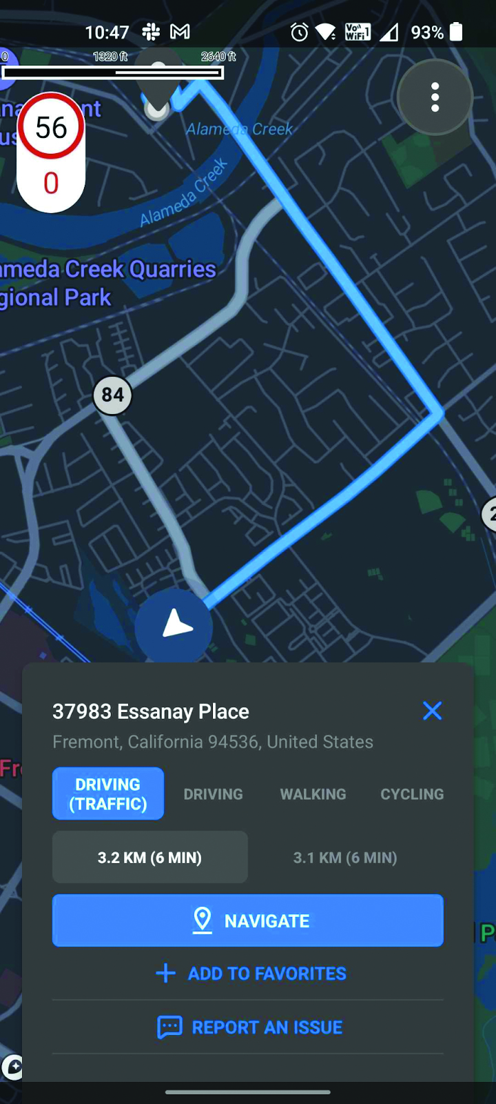
Mapbox, a platform that provides maps and location data for developers and works with such notable companies as Strava, General Motors, and Instacart, offers micro mobility solutions to help e-bike companies develop advanced navigation systems. E-bike maker Cowboy, and shared micro-mobility operator TIER Mobility, use Mapbox for their customizable navigation technology that provides turn-by-turn navigation with voice guidance, route optimization, traffic history and more.
Mapbox co-founder and principal evangelist Will White understands the capabilities and limitations of e-bikes that need to be considered when designing navigation technology for them. He pointed to two main obstacles to the adoption of e-bikes: rider safety and security from theft.
With these obstacles in mind, Mapbox is developing improvements in the ability to track the precise location of e-bikes by using their navigation platform. Additionally, White predicts that most e-bike companies will start to include radar devices to detect obstacles ahead and vehicles approaching from behind, as well as cameras, artificial intelligence and more to improve rider safety.
White is optimistic that e-bikes will be adopted as a mainstream form of transportation and is excited for Mapbox to be on the forefront of that innovative navigation technology.
Mapbox, a maps and location platform, has created new productsand platform updates to aid developers in making more accurate, data-driven decisions and improving overall user experience with advancement in location technology.
Navigation SDK v2.9 was introduced to provide pre-built navigation applications, compatible with Android and IOS, which will provide all the primary navigation components across a workflow using lines of code instead of starting from square one. The Drop-in UI is customizable to create applications that reflect a developer’s brand, rather than needing to manually develop a full end-to-end application.
Image: Mapbox
Navigation SDK Copilot, a backend analytics tool for CX on navigation applications, was launched and designed by Mapbox to collect trace files of navigation sessions and search analytics data from users. Developers can use this data to gather feedback and collective user data to create touch points with users and improve application experience based on their data-drawn conclusions.
Mapbox’s platform updates and product innovation also include improvements to its Matrix API, which can now support scheduled departure times and provide optimal driving routes creating a more accurate ETA. This innovative location technology is also designed to enhance fuel efficiency and decrease emissions.
Image: Mapbox
As map boundaries are constantly changing, Mapbox has expanded its visualization of map lines to update as frequently as the lines change. The expanded visualization makes updates quicker and improves the ability of Mapbox’s platform to give users the most up-to-date information.
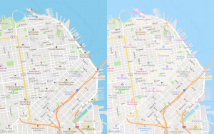
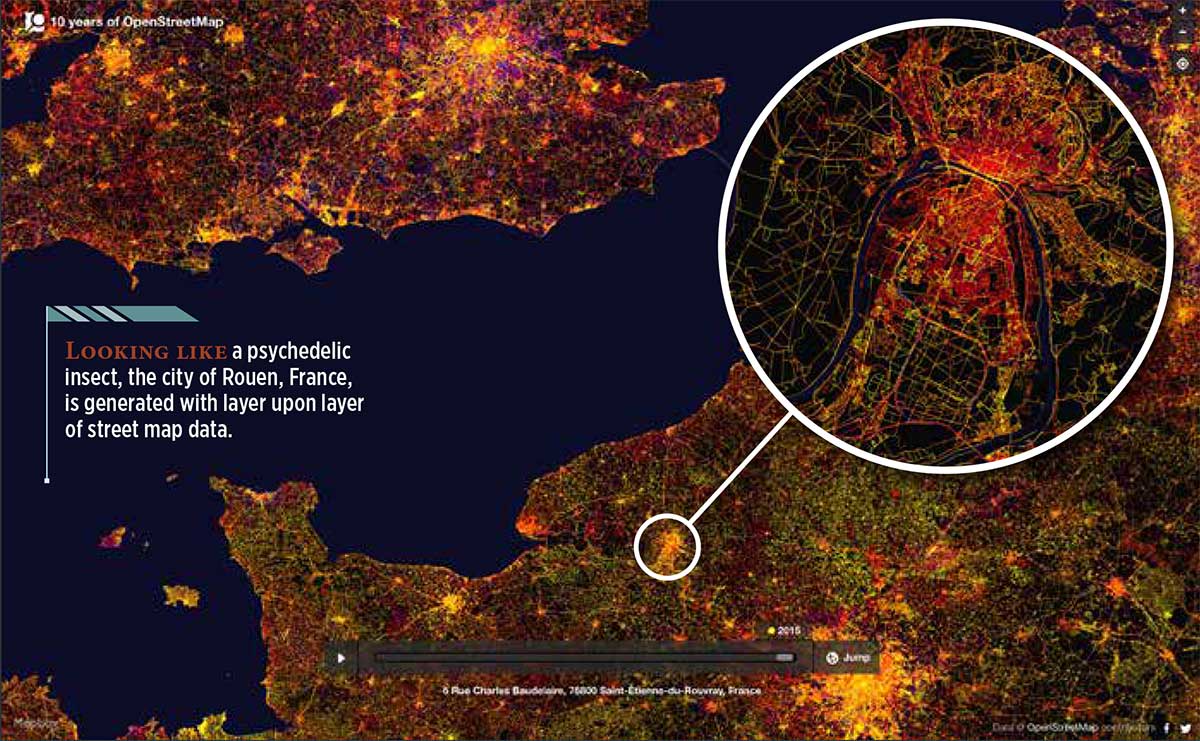
A tool developed by Mapbox explores “10 years of OpenStreetMap.” During that decade, hundreds of thousands of people mapped 25 million miles of roads in every country in the world.
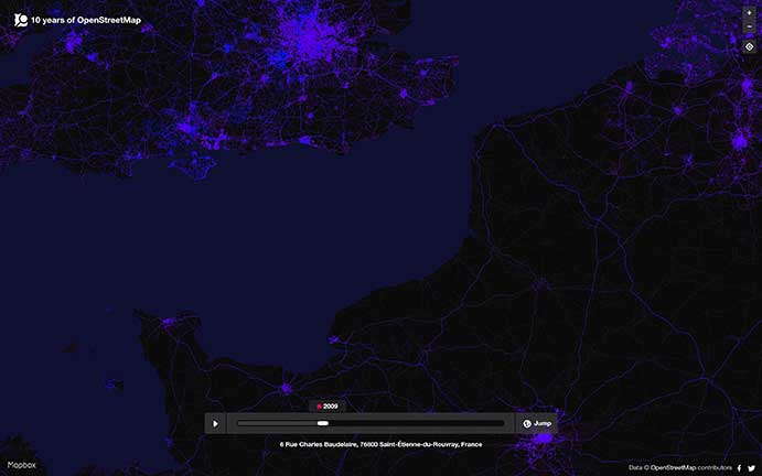
The internet tool uses a slider to show the data change over time. You can see additions and edits as they come online over the decade — a fascinating look at the intricate information that has been compiled. When a user drags the slider to the left, it’s easy to see how scant the information was only a few years into OpenStreetMap’s existence (the image at right shows the same European region in 2009 as the image at the top in 2015).
The same European region in 2009 as the image at the top in 2015. (Image: OpenStreetMap)
After GPS and GNSS, OpenStreetMap ranks high in the movement to make geographic information accessible. OpenStreetMap is a community-driven project to create the most detailed, correct and current open map of the world.
When Steve Coast began the project in 2004, map data sources were few, and largely controlled by private companies and the government. Coast changed the rules by creating a wiki-like resource of the entire globe, which everyone could use. Today, 5.2 million people use OpenStreetMap.
OpenStreetMap democratized mapping: all a contributor needed was time and a computer connection to add data about their country or their neighborhood. Besides GNSS, contributors use aerial imagery and low-tech field maps to verify that OSM is accurate and up to date. Others dedicate their energies to humanitarian projects, including disaster response following the Haiti hurricane and aiding South Sudan and Syrian refugees.
Location intelligence powers applications with data and “live maps” updated continuously.
According to Forbes, 70 percent of telecommunications companies consider location intelligence critical to their success. The intelligence data is provided by specialists such as Google, Esri, Here and PlaceIQ.
In January, Sprint and location intelligence startup Mapbox launched precision mapping technology with the Curiosity IoT network. The 5G network’s extreme bandwidth and low latency will allow Mapbox to collect higher volumes of richer data to create “live maps.” A live map is built not from traditional data surveys months or years before, but from data collected from hundreds of millions of location-enabled sensors that feed back information about the world in real time, including high-resolution video.
Mapbox uses artificial intelligence (AI) to turn the massive data flows into a picture of real time transit paths that can be used for precise, up-to-date routing.
Augmented Reality view from the Mapbox Vision SDK. (Image: Mapbox)
According to Mapbox CEO Eric Gundersen, maps that constantly update are essential to the internet of things (IoT). “As maps guide new smart machines on IoT networks, you remove the human in the middle that used to compensate for differences between the map and the real world,” he said. “Precision mapping services need to reflect the world as it is, at that precise moment so that those smart machines can travel safely and efficiently.“
According to Mapbox, smart machines such as drones and autonomous delivery carts will be able to make fast location and routing decisions using its detailed, updated maps.
Other companies that use Mapbox’s location services include IBM, Lonely Planet, Square, Tableau and The Weather Channel.
Advanced AI, robotics and autonomous vehicle services on Sprint’s dedicated IoT network will adapt to the real world using highly accurate, detailed and constantly refreshed maps.
Sprint and Mapbox are launching precision mapping technology with Curiosity IoT, allowing automated services that run on Sprint’s dedicated internet of things (IoT) network to move around the ever-changing world with pinpoint accuracy.
Smart machines, from drones to autonomous delivery carts, will be able to make fast location and routing decisions using highly detailed, accurate maps that are updated as the environment changes.
Sprint made the announcement this week at the Consumer Electronics Show being held in Las Vegas.
High Accuracy and Precise Detail with Live Maps. Mapbox offers what it calls a “live map”, a map built not from traditional data surveys months or years before, but from data collected from hundreds of millions of location-enabled sensors that feed back information about the world in real time.
Mapbox uses artificial intelligence (AI) to turn those massive data flows into a picture of real time transit paths that can be used for precise, up-to-date routing.
Image: Mapbox
Through its relationship with Sprint, Mapbox will leverage the inherent advantages of Curiosity IoT with 5G to take mapping to the next level. The network’s extreme bandwidth and low latency will allow Mapbox to collect higher volumes of richer data from the sensors, including high resolution video.
That data can be processed to identify and detect changes in the physical environment. Those changes are then incorporated into updated maps which can be distributed at scale to a wide variety of smart machines. The result is more accurate, more up-to-date maps that reflect the world in real time.
“Smart machine-based services need to be able to make immediate mobility decisions similar to the way a driver might react to construction, traffic or other obstacles on a street,” said Ivo Rook, senior vice president, IoT and product development at Sprint. “The launch of Mapbox’s precision mapping technology allows all intelligent machines to move at a level of precision never seen before. Our fully dedicated Curiosity IoT network and operating system — soon to be powered by Sprint’s mobile 5G connectivity makes this possible. From autonomous vehicles to advanced AI-based machines, precision mapping is a big step forward in making smart service models a reality for the immediate economy.”
“As maps guide new smart machines on IoT networks, you remove the human in the middle that used to compensate for differences between the map and the real world. Precision mapping services need to reflect the world as it is, at that precise moment so that those smart machines can travel safely and efficiently,” said Eric Gundersen, CEO of Mapbox. “Sprint’s Curiosity IoT network with mobile 5G provides platform services that make that real with high bandwidth, edge computing for object detection and data processing and super low latency.”
Curiosity IoT with 5G. Sprint 5G and Curiosity will create the new standard in IoT which features device data intelligence, over-the-air device management and chip-to-cloud security, the companies said.
When coupled with Sprint mobile 5G technology, Curiosity IoT’s dedicated, distributed and virtualized IoT core network is capable of supporting artificial intelligence, robotics, edge computing, autonomous vehicles and other IoT systems requiring extreme low-latency and high-bandwidth.
MicroStrategy Incorporated, a worldwide provider of enterprise analytics and mobility software, has launched MicroStrategy 10.11, the newest feature release to the company’s MicroStrategy 10 platform.
New capabilities in 10.11 include enhanced mapping for conducting geospatial analytics with Mapbox, a location data platform for mobile and web applications.
Version 10.11 also introduces out-of-the-box visualizations, intelligent recommendations for content, prompts for dossiers and a native MicroStrategy Library app for smartphones.
Library app. Users can now interact with data on dossiers via native apps optimized for iOS and Android smartphones. MicroStrategy customers can to operationalize the platform’s latest and modern interfaces with touch-optimized workflows on these handheld devices. Users can download the MicroStrategy Library app for iPhone by visiting the Apple app store or the MicroStrategy Library app for Android by visiting the Google Play app store, respectively.
Geospatial services powered by Mapbox. MicroStrategy 10.11 introduces MicroStrategy Geospatial Services and delivers new mapping capabilities via a native integration with Mapbox. The new and enhanced map visualization is available for dossiers on all interfaces, including MicroStrategy Desktop, MicroStrategy Workstation, MicroStrategy Web, MicroStrategy Mobile and MicroStrategy Library.
Users can visualize and analyze spatial data with advanced mapping capabilities, including intelligent clustering and aggregation, dynamic layers with interactive zoom and thresholds for attributes. This mapping service is available in addition to out-of-the-box Esri maps, and offers support for markers, bubbles and area types on a variety of map styles.
Geospatial Services features include:
Vector maps that improve performance and response times by 300% over traditional tiled maps, including for millions of records.
Global postal and administrative boundaries that let users bin their data by geographies ranging from Indian postal codes to Chinese prefectures.
Map style options tailored to the user’s visualization, including basic, light, dark, streets, topographic and satellite maps.
Advanced clustering and aggregation capabilities to understand spatial trends in data beyond density.
Full control of data layers and levels of detail based on a map’s zoom level.
Out-of-the-box visualizations. MicroStrategy 10.11 introduces three new visualizations that expand visual analytics capabilities for new use cases. With this latest release, users can plot and interact with data using waterfall, histogram and box plot visualizations, all of which are available out-of-the-box in all MicroStrategy interfaces.
“We are extremely excited about the launch of version 10.11 and all of its powerful new features. Business teams can now confidently take the first step towards establishing an enterprise-wide, data-driven culture on their own,” said Tim Lang, senior executive vice president and chief technology officer, MicroStrategy. “Version 10.11 empowers teams with self-service data discovery and departmental analytics, while creating the foundation for governed data discovery at scale and enterprise-worthy analytics. The latest capabilities available in MicroStrategy 10.11 are central to MicroStrategy’s commitment to deliver the next generation of enterprise analytics and advance our goal of building the ultimate analytics platform for the Intelligent Enterprise.”
To see MicroStrategy 10.11 in action, users can register for the upcoming webcast Unveiling MicroStrategy 10.11, to be held Wednesday, May 16,at 2 p.m. EDT.
Boundless, an open source geographic information systems (GIS) company, has announced a new partnership with Mapbox, a real-time location and mapping platform for developers.
The partnership enables developers to build applications that help people move through cities and understand their world better by giving Boundless users access to premium basemap content from Mapbox using Boundless Connect subscription service.
Additionally, Boundless has released a new version of its Desktop GIS software, which — along with Boundless Connect — was first introduced in November 2016. Boundless Desktop 1.1 includes increased support for PKI authentication, new options for styling, new image discovery and terrain analysis toolbars, in addition to Mapbox basemaps. Users can quickly search through an image library and discover image scenes based on location, cloud cover, acquisition date and more.
New Partnership
“This announcement signifies the massive growth and capabilities of Boundless Connect and accelerates the movement towards open GIS software and developer tools by expanding access to important content like Mapbox’s datasets and gorgeous maps,” said Andy Dearing, CEO of Boundless. “Partnering with Mapbox has been phenomenal and will only add value to our users. Making this data and content easily accessible through the Boundless ecosystem allows for significant productivity gains and unparalleled flexibility to our customers.”
Today, Boundless Desktop users can easily access this content through the Boundless Connect plugin. Mapbox content is also accessible through Boundless Suite and Exchange subscriptions. These basemaps include:
Mapbox Streets: A comprehensive, general-purpose basemap used for styling transit networks
Mapbox Outdoors: A basemap with curated tilesets and specialized styling tailored for adventurous use cases such as hiking or biking
Mapbox Light & Dark: A subtle, full-featured basemap that provides geographic context while highlighting data
Mapbox Satellite: A full global basemap, perfect as a blank canvas or overlay
Mapbox Satellite Streets: Combines Mapbox Satellite with vector data from Mapbox Streets, providing a comprehensive set of road, label and POI information; bringing greater clarity and context to the crisp detail in high-resolution satellite imagery
Additional premium services for routing, geocoding and more will be available in the near future.
“This partnership just makes sense. Mapbox and Boundless share a mission: helping developers build amazing applications that change the way people move and understand their world,” said Matt Irwin, head of strategic partnerships at Mapbox. “Boundless’s open, flexible platform pairs perfectly with Mapbox’s live-updating, customizable maps. The Boundless community now has tools and content, all in one place. We’re excited to see what they build!”
Boundless Desktop 1.1 Release
The Boundless Desktop 1.1. update includes increased support for PKI authentication, new options for styling, new image discovery and terrain analysis toolbars, and access to Mapbox basemaps.
Boundless Desktop is a cross-platform desktop GIS built upon proven open source software. Its ecosystem consists of more than 600 plugins that make working with geospatial data simpler.
The release of Boundless Desktop 1.1 signifies the company’s ongoing commitment to creating the world’s premier open GIS ecosystem. Boundless aims to continually provide customers with improvements and updates that make open GIS a viable and preferred alternative to proprietary GIS software.
Key features include:
Access to premium basemap content from Mapbox made possible through a new partnership with Mapbox.
Improved support for terrain analysis through a new toolbar that exposes common analysis techniques in a single location.
Increased support for imagery with a new image discovery plugin. This feature enables users to conduct a quick search through image libraries and discover image scenes based on location, cloud cover, acquisition date and more.
“Boundless continues to evolve its ecosystem of open GIS software with each release,” said Anthony Calamito, VP of product at Boundless. “Boundless Desktop 1.1 includes enhancements designed to make working with Desktop GIS easier for all. Access to premium basemaps, increased image capabilities and easy access to analysis tools were added in direct response to customer feedback. We encourage customers to submit their feedback to our Ideas Portal, so that we can continue to deliver software that meets the needs of our user base.”
Boundless offers a complete open GIS solution through a unique combination of technology, products and experts, to give enterprises deeper intelligence and insights into their location-based data. The Boundless platform is built upon open-source technology and open APIs that generate actionable location intelligence across third-party apps, content services and plugins for enterprise applications.