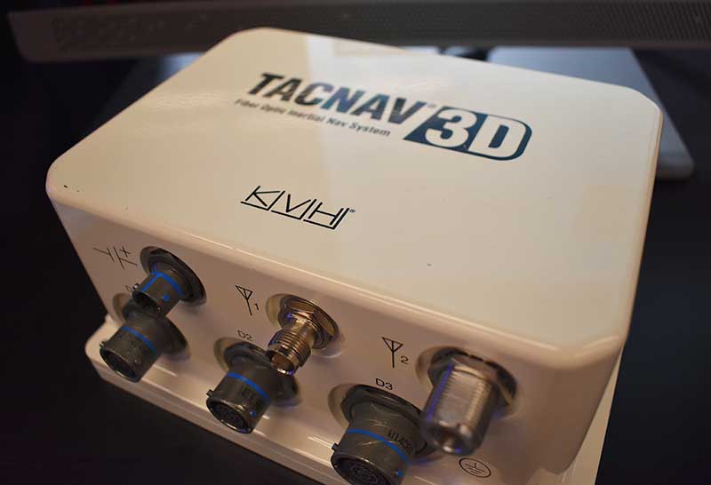
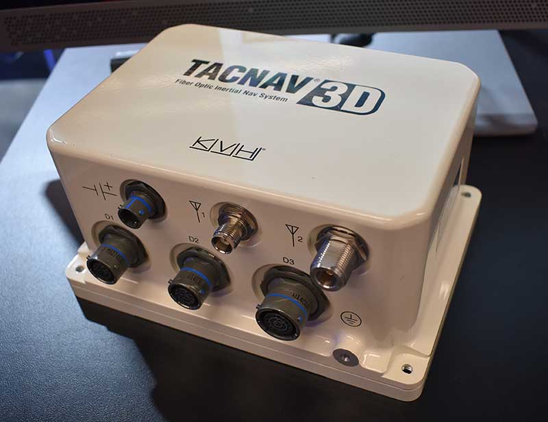
KVH Industries released its TACNAV 3D inertial navigation system, which includes an embedded GNSS and optional chip-scale atomic clock.
According to the company, the TACNAV 3D’s modular tactical design and flexible architecture allow it to function as either a standalone navigation solution or as the core of a multi-functional Battlefield Management System.
TACNAV 3D can integrate with a number of military GNSS systems and features one pulse per second timing assurance during GNSS signal loss, the company added. It also includes an iridium transceiver option that transmits and receives vehicle position, waypoint, and target location to and from a command center or other vehicles. It can receive and transmit data over ethernet, CANbus or RS-422 serial data bus.
“It incorporates a chip-scale atomic clock,” said Bill Houtz, business development — military and government for KVH Industries’ Inertial Navigation Group. “It has an embedded GPS, or we can work with other GPS external systems. It’s extremely flexible. It is an excellent SWAP-C alternative to the ring-laser gyros or other solutions on the market right now.”
Written by William Tewelow, GISP and Co-written by Jon Gustafson, GISP
Significant focus on infrastructure asset delivery and lifecycle must become a priority so that architects, engineers and construction (AEC) can leverage BIM systems for design, construction and management solutions.
Innovations in BIM applied to infrastructure construction projects will enable “smart” solutions. This article explores BIM for infrastructure insights and brings attention to closing the BIM divide between the vertical (buildings) and the horizontal (linear) infrastructure industries, such as roads, bridges and pipelines.
For smart systems to be applied to infrastructure, CAD needs to evolve to the point where those multi-dimensional models can integrate with geographic information systems (GIS). The larger the project, the more necessary it is for a seamless data transition from the local engineering scale to the municipal, regional or national reference systems.
Autodesk defines building information modeling (BIM) as an intelligent 3D model-based process that gives architecture, engineering and construction (AEC) professionals the insight and tools to more efficiently plan, design, construct and manage buildings and infrastructure.
It is like a GIS in many respects, but applied locally to a structure. It is able to do many common geospatial calculations. It is still an evolving technology, but it is clear that soon it will do for AEC and facilities management what GIS did for surveying and cartography.
A smart move
Systems have evolved augmenting our abilities with built-in applications that can integrate connected data and systems to enhance and extend our capabilities. These systems are termed smart, which has become the newest marketing buzzword.
Everything is getting the smart label. Along with the label is an expectation that the lines between the physical and the digital worlds are blurring as we slip ever nearer the veil wherein we will simultaneously co-exist in both worlds.
Smart also infers it is connected to the digital cloud, that seemingly infinite expanse measured by petaflops, into which artificial intelligent algorithms augment everything with contextually aware information overlaid atop our own experience of the world.
Of course, this view has its pitfalls and cautionary tales, and every step we take into the future we lose some connection with the past. For example, everyone can use a calculator, but are times tables even taught anymore? Automation leads to complacency.
When CAD was unimaginable
Let’s take a brief look backward. The year was 1978, my second year of high school. I took drafting class as an elective and would end up doing so for the rest of the time I was in high school, accumulating enough credit hours to graduate with a vocational degree equivalent in architectural design. Those were the days of drafting tables, slide rules, French curves, triangles, keen eyes and steady hands.
The last year of school, there was talk of something called computer-aided drafting or design (CAD) that would make all we were doing obsolete. It seemed impossible at the time. Especially after I took a brand-new summer course called computer programming. Computers were large, heavy, clunky things that had limited abilities. They were basically responsive text machines. Program something in BASIC, save it, and then from the DOS command window, run it over and over again.
I remember reams and reams of green and white paper two foot wide fed by geared teeth, and pages of pages of our coded programs that we would have to pour over looking for the mistake in the line of code. And, this long and lengthy code was merely to archive and sort information or make the computer draw a cat or some other object using “X”.
We would all stand around the dot matrix printer as line by line the image took shape on the printed page. There was that wondrous feeling of success creating something having first conceived it in the mind then, like digital-smiths, forging it in a non-physical space and holding it in our hands. But I could not understand how that blinking white cursor on a black screen could ever replace the rich colors and smoothed lines of the beautiful architectural drawings I had spent years learning.
I felt confident the stories of our trade being overtaken by CAD were greatly exaggerated. That lesson taught me that change is inevitable and far beyond our rational ability to comprehend what is possible based on our current understanding. I watched as computer-aided design did take over, giving engineering and architectural drawings multidimensional context.
Horizontal lags behind
Now, let’s jump back into the present. The horizontal industry is behind the vertical industry with respect to project management deliverables. In part, this disparity will be aided by the Geospatial Data Act which was passed into law on Oct. 5, 2018.
The linear model is approximately 10 years behind the vertical model, especially for above-ground assets and facilities. However, recent technology advancements — augmented reality (AR), unmanned aircraft systems (UAS), indoor lidar and modeling software — and influential advocacy initiatives (such as public agency innovation programs like smart cities) are starting to enable digitally integrated management of asset information more holistically. Indeed, there is urgency for these linear systems to be adequately captured.
The Feb. 6 explosion from a ruptured gas line in San Francisco showed the dangers of not having an adequate map of the subsurface infrastructure. Fortunately, no one was injured, but damage from subsurface infrastructures can be deadly like the San Bruno disaster in 2010.
Gas line explosion damage in San Bruno, California. (Image: U.S. Department of Transportation)
The “Call Before You Dig” law was enacted for this very reason. At the very least, problems with linear infrastructure can negatively impact a city’s quality of life and budget such as a water main break or a broken sewer line.
Looking ahead 5-10 years, horizontal infrastructure designers and installation companies will use 3D modeling tools as standard practice in an open data sharing environment allowing other networks to access the information and add it to their own projects.
Imagine a county’s 811 system, the universal number to call before you dig, and instead of calling, it is an app on a users’ phone. A requester submits a short form and receives a text when the application is approved, usually within minutes, and is then able to view an augmented reality overlay of the subsurface infrastructure in the vicinity beneath the ground where the requester’s project is taking place.
This approach has economic benefits, providing faster turn-around times, increasing citizen engagement and improving the safety of communities. Over time, it is a “collect once and use many times” system — it will reduce demand on city staff and billable hours, saving cities money.
The same technology is also available for construction projects, providing schematics to see pipes, ducts and wires in walls, floors and ceilings. This is not science fiction. Existing condition data is already being collected in 3D, so it is logical to anticipate engineering design will be prompted to support ongoing 3D collection efforts and begin doing work in 3D.
Using BIM from the outset of a project builds this into a system that can be accessed later. However, the use of these advanced augmented reality technologies are limited to certain geographic areas with enough funding and technical capabilities. This is primarily in large urban areas, new growth areas, and redeveloping areas of a city; however, large infrastructure projects such as pipelines, railroads, highways, bridges and hyperloops will have to develop high-resolution models that will capture some of the surrounding areas and benefit all communities along the routes helping to bridge the disparity of the BIM divide.
In time, as costs come down and the technology improves and becomes easier to use, all communities will benefit from and incorporate this emerging technology.
Photo: Krauchanka Henadz/Shutterstock.com
BIM for intelligent infrastructure: sensors and structures
Critical to BIM for smart infrastructure is the fusion of sensors, data and infrastructure. Sensors will be embedded within and affixed to physical assets for the purposes of collecting data and self-monitoring for machine learning, maintenance and repair. Networking internet-enabled devices that actively and passively sense is at the core of the internet of things (IoT). Data from these IoT devices will improve physical asset management, creating unique opportunities for agencies, especially when considering how machine learning can discern patterns in data to detect anomalies, and improve safety such as self-aware systems that can heat road surfaces when precipitation is detected in below-freezing temperatures.
The digitizing of the physical world will take place with greater demand for higher resolution capabilities. Physical structures will require an exact computerized replica, referred to as a Digital Twin. An effort is underway by the Open AR Cloud Organization (OARC) to create an open standard for this digital twin of the world, so that applications and innovation will not be hampered by proprietary systems.
Yohan Baillot, CEO of ARcortex and founder of the Open AR Cloud, explained if there is no open standard, something developed in one system may not align with applications viewed in another system. This could be costly and disastrous for transportation and construction projects. Point in case would be the above example of Call Before You Dig,if a gas pipeline is incorrectly depicted and a work crew ruptured it.
This Digital Twin is both a high-resolution GIS and a basemap for both vertical and linear BIMs to connect into. Knowing the location of subsurface assets is foundational to the increasing investment into smart cities, which is forecast to become a $3.5 trillion industry within the next seven years.
David Rouse (2017) defines smart cities as cities that use information and communication technologies to increase operational efficiency, share information with the public, and improve both the quality of government services and public well-being. Using smart devices, communication among the devices and with the entities managing those devices provide deeper insight on device behavior and the ability to develop algorithms to change device parameters using other sensors in close proximity.
All of this data can be used to optimize asset performance over time. In the U.S., San Francisco, New York, Chicago, Los Angeles, Boston and San Jose all have active smart city projects advancing connectivity (Nominet 2018).
Intelligent infrastructure augments users’ abilities by the multiplicity of sensor arrays (self-monitoring devices, RFID, Wi-Fi, GPS receivers, cameras, etc.) communicating with decision-support systems as well as other sensors — the internet of things (IoT). For instance, high mast cameras combined with artificial intelligence algorithms for object recognition deployed along a stretch of highway allows stakeholders to extract important insights of that physical asset (such as surface condition, traffic flows and vehicle counts) and provide that information in real time to emergency response crews, police and security, maintenance vehicles, network-connected vehicles and others.
Digital integrations
Intelligent transportation systems are entering the next generation enabling vehicle-to-infrastructure (V2I) interactions. The U.S. Department of Transportation (2018) website states,
V2I technologies capture vehicle-generated traffic data, wirelessly providing information such as advisories from the infrastructure to the vehicle that inform the driver of safety, mobility or environment-related conditions. State and local agencies are likely to install V2I infrastructure alongside or integrated with existing ITS equipment.
The Open Connectivity Foundation (OCF) endeavors to provide open standards and certification to make connectivity easier, more reliable and more secure by bridging IoT ecosystems.
Specifically, OCF specifications can be used to develop vehicle data model translators that enable remote fleet management for autonomous vehicles, OBD device interactions (vehicle performance monitoring) and crowdsourcing of data models for continued development (Open Connectivity Foundation 2018). Currently, many transit agencies are seeing growth in equipping rolling stock with IoT devices including GPS, Wi-Fi and traffic light preemption, which improves fleet optimization and data accessibility, and enables better congestion management as well as increased system performance (American Public Transportation Association 2018).
Crowdsourcing data from web-based and mobile applications is a popular public engagement mechanism. Crowdsourcing at its most basic level is the aggregation of (big) data from a large group of people. From an asset management perspective, leveraging the general public’s direct and indirect collection of data brings deep insight into asset performance and condition.
The data collected provides the ability to better plan transportation systems with demand modeling, predictive analytics, event response times to identify those impacted and determine where additional capacity is needed, and to provide personalized services (such as through email and text) including weather-related events impacting the commute.
Applications such as Waze empowered the public with the ability to report hazards, construction zones and other concerns on the road and shoulder that DOTs can use to dispatch resources to address the situation/issues quickly. Furthermore, Alavi and Buttlar (2019) identified sensing capabilities of smartphones and their crowdsourcing power for monitoring several distinct civil infrastructure systems such as pavement.
Conclusion
In summary, BIM for infrastructure overlaying a robust GIS plays a critical role for supporting advanced technologies for integrating dynamic IoT and crowdsourced data.
Infrastructure asset owners are encouraged to recognize the importance of BIM-oriented policy and practices and invest in required initiatives that make incremental progress towards a smart infrastructure vision.
BIM is the foundation of intelligent infrastructure and defines the backbone of smart cities.
References
Alavi, Amir H., and William G. Buttlar. 2019. “An overview of smartphone technology for citizen-centered, real-time and scalable civil infrastructure monitoring.” Future Generation Computer Systems 93: 651-672. https://doi.org/10.1016/j.future.2018.10.059.
Jon Gustafson, PS, CFedS, PMP, GISP is a management consultant with one of the world’s largest professional services companies, WSP (https://www.wsp.com). He is an accomplished business-oriented technical professional consistently recognized as an industry leader in multi-jurisdictional land surveying practice, geospatial policy development and program/project management. He helps his clients address infrastructure technology deployment challenges by developing effective recommendations/guidelines focused on advancing civil integrated management practices and innovations. Some recent projects include developing data governance strategies for major infrastructure programs, conducting applied research on digital project delivery initiatives, advancing UAS integration, and formulating geospatial technology strategies for a public agency.
Hexagon’s Geospatial Division has released V2018.1 of the Luciad Portfolio. According to the company, V2018.1 focuses on further expanding 3D capabilities and includes additional data formats and standards for users in military and maritime domains.
To accomodate organizations’ expanding geospatial data, LuciadFusion added a RESTful API to automate the entire process of data crawling.
As a part of the update, LuciadFusion and LuciadLightspeed, the server and desktop solutions, have added support for the E57 point cloud format and automate point cloud data optimization through the Tiling Engine API. LuciadLightspeed now includes inland electronic navigational charts and updated support for military symbology with the U.S. Department of Defense Joint Military Symbology Standard and the NATO Joint Military Symbology Standard APP-6D icons.
In addition, LuciadRIA now allows users to draw a multitude of complex lines and military tactical graphics in 2D and 3D in the browser.
“The additional 3D capabilities of Luciad V2018.1 support our vision for a smart digital reality, empowering users to unlock the power of advanced geospatial analytics and visualizations,” said Mladen Stojic, president of Hexagon’s Geospatial Division.
Version 20 of the Global Mapper Software Development Kit (SDK) is now available, along with the accompanying Lidar Module SDK. Mirroring the most important capabilities of the desktop version of the software, the powerful developer’s toolkit provides software engineers with the means to embed the latest geospatial technology into their custom applications, according to software maker Blue Marble Geographics.
An elevation contour image in Global Mapper SDK. (Screenshot: Blue Marble)
Among the highlights of the version 20 release are dramatically improved vector data performance in both the 2D and 3D environments, updated 3D mesh rendering with colors now displayed in the 2D view, and faster display and export of online tiled datasets, the company said.
For more than 25 years, Blue Marble’s affordable, user-friendly GIS software has been meeting the needs of users in industries including software, oil and gas, mining, civil engineering, surveying and technology companies, as well as government departments and academic institutions.
The Global Mapper GIS application can display, convert and analyze virtually any type of geospatial data. The Global Mapper SDK and Lidar Module SDK provide software developers with a toolkit for accessing much of this functionality from within an existing or custom-built application.
The SDK also enables the creation of custom toolbars and extensions to enhance the data processing and analysis functionality of the standard version of Global Mapper. This capability allows in-house developers to create a unique version of the application to meet their specific needs or for software companies to build custom products for commercial distribution.
The functional highlights of the latest version of the SDK effectively illustrate the continued evolution of 3D GIS technology and Blue Marble’s commitment to providing a superior data processing engine for managing, visualizing and analyzing increasingly large 3D datasets. Such is the case with the improvements that have been made to the display performance of vector files with faster rendering in both 2D and 3D Views.
The display of 3D meshes or models, such as those created in Global Mapper’s Pixels-to-Points tool, has been improved with the photo-realistic colors now displayed in the top-down view. Online data processing has also seen improvements with significant speed increases when loading and exporting tiled data sources.
Additional upgrades to the SDK functionality include improved box resampling of color images, especially those with palettes; several new supported formats, including Cyclone PTX and Autodesk Recap (RCP and RCS) point clouds; new projections and datums, including GDA2020 (Australia) and TUREF (Turkey); and support for Intermap’s online NextMap worldwide elevation dataset.
For users of the Global Mapper Lidar Module, the version 20 SDK release also introduces a wealth of new and updated functionality. Point clouds can now be thinned, from both a 2D and 3D perspective, reducing file size and improving efficiency; a gridded layer can now be created from the classification values associated with lidar points; and a new scripting option has been added to apply colors to a point cloud from underlying imagery.
“The Global Mapper SDK has become one of the most important components of Blue Marble’s suite of geospatial products,” stated Patrick Cunningham, Blue Marble President. “Motivated by the rapid emergence of the desktop software as a major player in the GIS industry, developers are increasingly turning to the corresponding SDK to leverage the software’s powerful geoprocessing tools in a wide variety of third party applications. The improved data handling capability of the version 20 release demonstrates our commitment to providing tools that work efficiently with even the largest datasets.”
Datumate’s DatuSurvey 5.5 software offers 2D vectorized measurements and 3D point clouds models. (Screenshot: Datumate)
Datumate, a photogrammetry solution and 3D mapping software developer, has released its updated DatuSurvey 5.5 software, which offers 2D vectorized measurements and 3D point cloud models.
According to the company, with the updated software, users can now process thousands of images locally in an accelerated mode while maintaining survey-grade accuracy and professional engineering results. Organizations can also deploy Datumate’s solutions on single or multiple computers and take advantage of the accelerated and user-friendly processing of the project field data.
In addition, DatuSurvey 5.5 can process large amounts of drone imaging data locally and quickly. The software can also achieve survey-grade accuracy and geo-reference the model quickly and easily, the company added. Finally, it can plan and execute consecutive drone missions on unmapped and frequently changing areas.
According to Datumate, its team improved the geo-referencing workflow of the software when using ground control points. Users can now quickly and easily mark ground control points using zoomed-in image projections.
The company also added the ability to import coordinates to DatuFly Professional in addition to on-site or on-map mission planning. This will enable an efficient and accurate drone mission execution on specific and designated areas without depending on satellite and map source views, Datumate said.
According to SimActive, users can now process raw data, produce point clouds and digital surface models, and perform volumetric calculations with the Correlator3D workflow. (Photo: SimActive)
SimActive has updated its Correlator3D end-to-end photogrammetry software to include tools for users to generate precise statistics on mining activities, with improved volumetric calculation.
The integrated tools allow users to generate precise statistics on mining activities.
The Correlator3D software performs aerial triangulation and produces dense digital surface models, digital terrain models, point clouds, orthomosaics and vectorized 3D features.
Applications like mineral extraction monitoring can be done seamlessly within the software.
Users can process raw drone data, produce point clouds and DSMs, and perform volumetric calculations in the same Correlator3D workflow.
“Our clients often require project delivery within 24 hours”, said Jennifer Waugh, principal at Alietum Ltd., a Canadian company using unmanned technology to support construction, consulting and government clients. “SimActive enables us to meet this demanding turnaround time.”
Based in Montreal, Quebec City, Canada, SimActive has been a developer of photogrammetry software since 2003.
In the not-too-distant future, the following scenario may take place.
Image: Stockvault
A corporation owns an improved property in a large metropolitan city and has decided to sell it to a prospective buyer. Through a series of electronic messages and high-tech operations, the seller, buyer, their respective counsels, lending institutions and a title company are provided with documentation stating the condition of the site along with holograms and 3D digital models worthy of a science-fiction movie. In a matter of minutes, the deal is closed with monies and titles silently swapping places out in the ether.
Behind the scenes, the surveyor is a big part of this transaction. But how will the operation of the land title survey look in the future? Like everything else, artificial intelligence (A.I.) and blockchain technology will play a substantial role in surveying. I don’t profess to be the next Carnac the Magnificent, but it could look like this…
HOW IT ALL STARTS
The seller contacts their corporate attorneys to begin the contractual process. Requirements for the sale include acceptable and insurable conditions of the site and a clean title policy from a title insurance company, so the latest land title survey requirements will be held for site and title review. Once the seller and buyer are committed to a sale of the subject property, a blockchain is established in a transactional database to track every step of the sale.
Image: GSA
The attorney will consult with “Sheldon,” an artificial intelligence system built by a leading e-commerce company and designed to assist with business-to-business commerce. Sheldon will be used to secure the services of a land surveyor for the transaction. By researching available consultants based upon the information for the parcel contained within the blockchain, Sheldon contacts firms that could meet the criteria for this part of the transaction.
Once an appropriate firm is chosen by Sheldon, the data for the survey within the blockchain is uploaded to “Thomas,” a digital assistant designed specifically for surveyors. Thomas works with Sheldon and the blockchain to formalize an agreement, secure the necessary insurance requirements, and finalize a payment schedule for services.
ENTER THE SURVEYOR
Once the project is secured, Thomas creates a project file, downloads current satellite images, GIS data (including parcel, building and utility information), and recorded documents for the subject parcel. Among the information is parcel data for the project site. This data is based upon historical land surveys and converted into an accurate dataset in which most of the property and land corners are now included in the GIS database. All corners within the database have been installed or upgraded to contain an RFID chip imbedded within the top of the marker.
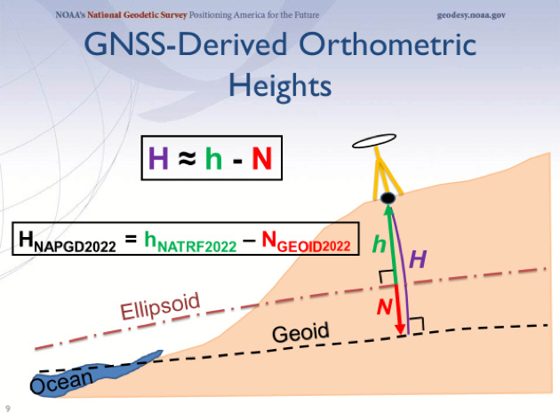
Image: NOAA
These GIS databases also take advantage of ongoing advancements of the North American Terrestrial Reference Frame of 2022 (NATRF2022). Beyond the initial implementation, the National Geodetic Survey has incorporated additional precision gained by improved L5 satellite reception and other nations’ satellite constellations in sub-centimeter location with most survey-grade receivers. Thomas compiles all site data into a comprehensive package for submission to the surveyor.
Because of the advancements with instrumentation and sensors in locating improvements both above and below the surface of the ground, the latest land title survey standard has moved all optional Table A items into required information to be provided on the plat. The standard also now requires a drainage analysis to be prepared to determine how the subject property relates to the adjacent parcels.
Thomas reviews the current backlog of project managers and assigns/transmits the project to the first available team. The chosen survey project manager receives the project information and creates an Ethereum blockchain file to work with the master blockchain and begin the survey process. By creating additional survey programming working in conjunction with the project blockchain, all parties involved in the transaction can monitor progress every step of the way.
The first responsibility of the survey PM is to work with Thomas to evaluate the existing data available for the project location. Current conditions from satellite imagery, improvement and utility information from existing governmental GIS databases, and parcel/easement information from recorded document sources are used to determine flight paths for UAVs utilizing multiple sensors, avoiding substantial obstacles. This process will also establish areas to be surveyed/verified by mobile methods where aerial data cannot be obtained.
All available information is processed by Thomas to establish the most efficient routes and methods of data collection for the parcel through software designed to compile and review spatial datasets. This software is specifically designed to review existing information for potential conflicts in flight and on-the-ground obstacles. Once completed, a flight plan for the UAV and route plan for the autonomous mobile vehicle will be reported with missed areas identified for manual data collection.
FIELD WORK ON STEROIDS
When the time arrives for field work to begin, a technician is dispatched in an autonomous electric truck pre-programmed to go directly to the site. The truck is loaded with various survey-grade instruments and equipment (all GNSS equipped): vertical take-off fixed wing and multi-rotor UAVs (both with lidar, photo, hyper-spectral, and GPR sensors), an autonomous mobile ground robot (with GPR/lidar sensors), and an RFID reader for boundary location.
The technician works with the equipment through a universal tablet computer controlling both aerial and ground data collection simultaneously, depicting the progress of the work in real time. This gives the technician time to locate the boundary points with the handheld GNSS receiver/RFID reader to verify the limits of the property.
Once the autonomous work is finished, the technician processes the data on site, and software compares collection coverage versus the initial site review. When processing is complete, the technician will utilize a handheld GNSS receiver with lidar sensor to obtain remote areas not collected by the other methods.
The remaining data is compiled with autonomous data and re-analyzed for overall coverage and approved by the software for completeness. Once the computer determines everything has been collected, the technician checks the complete box and leaves the site.
OFFICE WORK AND WRAP-UP
The final field data is uploaded to cloud servers as the technician leaves the site and the survey PM is notified by electronic message of the field task completion. Thomas, the digital surveying assistant, takes the lead and begins the final processing. The data is reviewed for completeness, parsed for any anomalies within the downloads, and compiled into one database for building a 3D model of the site.
Photo and lidar data are compared for accuracy, utilities are verified against existing records and easements, and building characteristics are matched against governmental records for zoning code compliance.
Once this analysis is complete, the final drafting takes place to create the final deliverable. While the data within the model contains attributes of each entity, labels are placed interactively throughout the site to help depict the site information. This model is also suitable for use by architects and planners to utilize in their B.I.M. design programs, so the quality in the modeling output is top notch.
The final deliverable contains an overall report documenting site conditions, drainage characteristics and physical conditions of various entities. This report will also detail potential site encroachments, possible drainage issues, and zoning/parking red flags. Thomas will report back to the survey PM that all final checks have been made and deliverables made for submittal to the client, leaving only the final transmittal left to do.
Once the deliverable is received by the client, Sheldon (the B2B automated assistant) recognizes the delivery and begins the process of payment to the surveyor. With standardized surveys, automated assistant/analyzation systems, and trackable processes through blockchain, the client gets a quality product at a market rate in an acceptable timeframe and the surveyor gets paid in a reasonable period.
THEN WE ALL WOKE UP TO REALITY…
Maybe this fictional situation for land surveyors won’t be a reality in my lifetime, but I’m not willing to bet against it. I look back at my short 30+ year career and still marvel at the technological advancements yet I acknowledge we are still turning a corner in computing power (see May’s column). I remember the introduction of laser scanners and lidar sensors as future data-collector saviors, gathering multitudes of precise and accurate data much faster than any mortal. Now we have UAVs that can soar above us with little interference and provide images and data at a reasonable cost, so technology does benefit us.
But what about data that is automated to the point it is beyond the control of the surveyor? And what does this do to our shrinking surveying workforce?
Some may say it is a godsend on both accounts. I personally won’t turn out a product or survey in which I don’t have a good understanding of what the data represents or how it was collected; that violates a code of ethics of practicing beyond my expertise. I also don’t think automation will eliminate our technicians, but the surveying profession will need to provide adequate training for our next generation.
“I’M SORRY, DAVE. I’M AFRAID I CAN’T DO THAT.”
We live in a world in which so many things are automated (Alexa, Siri and “Hey, Google”) to assist us with even the most mundane of tasks. Amazon recently introduced a store where the customer doesn’t stop at a cashier; just grab the items off the shelf and walk out. Apple introduced its latest iPhone that opens by recognizing your face. Automation is here to stay, whether we like it or not.
Image: MGM
An article by the Pew Research Center (“Automation is Everyday Life“) described in detail the amount of anxiety that automation instilled in Americans. Many felt that while there are opportunities to increase productivity and profitability in many sectors, that will be offset by lost jobs replaced by automation. Others were also troubled by automation becoming more prevalent in medical treatment of senior citizens.
For many, the thought of automation isn’t nearly as scary as the concept of “artificial intelligence.” While most of the processes involve machine learning (ML) and refining results based upon increasing datasets, computing power is increasing and introducing new methods including “deep learning.” The algorithms being produced by deep learning through neural networks are making smarter decisions as they use larger and more complicated datasets.
From a June article for The Atlantic, Henry Kissinger (yes, that Henry Kissinger) offered these thoughts on A.I.:
Henry Kissinger (Photo: The Atlantic)
Ultimately, the term artificial intelligence may be a misnomer. To be sure, these machines can solve complex, seemingly abstract problems that had previously yielded only to human cognition. But what they do uniquely is not thinking as heretofore conceived and experienced. Rather, it is unprecedented memorization and computation. Because of its inherent superiority in these fields, AI is likely to win any game assigned to it. But for our purposes as humans, the games are not only about winning; they are about thinking. By treating a mathematical process as if it were a thought process, and either trying to mimic that process ourselves or merely accepting the results, we are in danger of losing the capacity that has been the essence of human cognition. (June 2018)
He also makes a strong statement that the United States needs to develop a national vision for AI like other countries (i.e. China, Russia, India) to stay competitive in computing power.
TRANSLATING ARTIFICIAL INTELLIGENCE INTO SURVEYING
The point of this discussion wasn’t to be “doom and gloom” of technology. I look forward to enjoying many of the advancements of AI and blockchain advancements. Many of the advantages of both technologies have not been brought to the surveying forefront yet, but it will only be a matter of time.
My one big fear to automation attempting to overtake and regulate some functions of surveying leads back to boundary determination and the increasing use of holding technology/mathematics over monumentation, hence Kissinger’s comment regarding human cognition. The rules of construction will always hold true in my boundary analysis until there is a time and place where all parcels (original and retracement) are created in a mathematical vacuum.
I also don’t see a timeframe yet that reduces the amount of measurement error between survey practitioners utilizing differing methods and technologies. Survey equipment manufacturers are still refining ways to get more precision from their GNSS receivers, yet still put them on a pole with a bullseye bubble that needs constant checking. Even tribrachs and total stations aren’t checked as often as recommended, but we always seem willing to argue over who measures better.
Until we get more consistent in our overall measuring as a profession, I’ll hold off on worrying about artificial intelligence taking over.
In the meantime, let’s back off calling a corner monument off by 0.03’ just yet. Let’s hope that when A.I. does become more prevalent, the surveying profession will have its collective heads wrapped around our own intellect as well.
The ZEB-REVO RT is the next generation of the ZEB-REVO, GeoSLAM’s lightweight handheld laser scanner that allows the rapid and simple mapping of complex, indoor and multi-level spaces.
The ZEB-REVO RT uses technology to seamlessly connect the scanner to a mobile phone or tablet, allowing for real-time data visualization as you walk and scan, the company said.
GeoSLAM launched its new offering in Europe at Intergeo in Berlin, Germany. This month, GeoSLAM will be premiering its new products to American audiences at the Fall BIM Forum, held Nov. 6-8 in Dallas. BIM stands for building information modeling.
The simultaneous scanning and processing of 3D data removes any need for post-processing, effectively slashing project survey times in half. The technology is so rapid, users can scan and process a three-story building in just 30 minutes, the company added.
The successor to GeoSLAM Desktop, GeoSLAM Hub is the latest version of the award-winning SLAM registration software. Enabling end-to-end data capture, the tool allows users to process, view, merge, edit and output 2D and 3D deliverables all from within the one software package.
The mission statement of the BIM Forum is to explore technological and delivery innovation and performance improvement through BIM and new means of collaboration. This mission dovetails with GeoSLAM’s technologies.
To find out more about GeoSLAM’s activities at Fall BIM Forum 2017, visit the events page or visit GeoSLAM in person at Booth 627.
Hexagon AB has acquired Luciad, a Belgian-based software company specializing in the visualization and analysis of real-time geospatial information.
Luciad’s visualization technologies support live connections to dynamic sensor feeds in a 3D environment. The result is a 5D digital reality — real-time, rapid fusion of multi-source content and the ability to perform analytics on-the-fly.
These intuitive command and control systems benefit all kinds of applications, from public safety to smart cities to defense and intelligence, enabling users to make critical decisions based on changing information in real time.
“This acquisition strengthens Hexagon’s ability to deliver smart digital realities, enhancing our Smart M.App platform with 3D, 4D (real-time sensor feed integration) and 5D (dynamic analytics) capabilities,” said Hexagon president and CEO Ola Rollén. “The ability to rapidly integrate sensor data in a visually compelling environment provides the geospatial location intelligence and situational awareness necessary for mission critical operations.”
Luciad has more than 100 highly-skilled professionals in eight countries, with 100,000 users of its technology globally.
Luciad will be fully consolidated as of today, operating within Hexagon’s Geospatial division. The company’s turnover for 2016 amounted to 16 MEUR.
Trimble Earthworks for Excavators and Earthworks for Dozers brings integrated 3D aftermarket excavator automatics capability to machine control.
A new dozer configuration moves the receivers from the blade to the roof of the cab. Reengineered from the ground up, Trimble’s next-generation grade-control platform features intuitive software that runs on Android.
(Photo: Trimble)
Android System. The Trimble Earthworks grade-control application is built on the Android operating system. It was developed based on feedback from construction equipment operators, resulting in an interface optimized for productivity.
Colorful graphics, natural interactions and gestures, and self-discovery features make the software easy to learn. Each operator can personalize the interface to match their workflow, and a variety of configurable views make it easier to see the right perspective for maximum productivity, the company said.
Using Android, users can download other applications that provide the operator with useful tools inside the cab. Contractors can use the Trimble TD520 display or a third-party Android device.
Excavator Automatics. When the excavator is placed in Autos mode, the operator controls the stick, and Trimble Earthworks controls the boom and bucket to stay on grade, reduce overcut and increase production. This allows operators to achieve grade consistently, with high accuracy and in less time.
Mastless Dozer Configuration. Trimble Earthworks for Dozers mounts dual GNSS receivers on top of the cab to eliminate masts and cables traditionally located on the blade. The dual GNSS receivers are designed for steep slope work and complex designs with tight tolerances. According to Trimble, the new configuration keeps valuable receivers safer and can also save contractors time by reducing the time needed to remove and reinstall them each day.
Earthworks Highlights
Grade-control app runs on the 10-inch Trimble TD520 touchscreen
Android display.
Excavators can work semi-automatically, allowing operators to create smooth, flat or sloped surfaces more easily.
Software and hardware give operators of all skill levels the ability to
work faster and more productively.
Allows data files to be transferred to or from the office wirelessly and automatically, keeping designs current.
Fugro is enhancing its mapping services with the introduction of an integrated software package that creates realistic, yet spatially accurate, high-resolution 3D building models using oblique imagery.
The product will benefit emergency responders during critical infrastructure planning, as well as those involved in infrastructure development, utilities and property management.
Fugro, partnering with Skyline Software Systems, provides infrastructure management professionals with robust new capabilities in oblique mapping, including detailed 3D models and view shed studies for advanced visualization and analysis.
Announcing a strategic partnership with Skyline Software Systems Inc., Mike Wernau, Fugro’s Oblique program manager explained, “We are now able to take a 2D oblique product and deliver a realistic 3D environment with enhanced viewing, query, analysis and reporting options. The value that users are going to discover as a result of this software fusion is something the market has really never seen before.”
The new partnership offers clients an integrated oblique viewing and 3D modeling software. The integration of TerraExplorer and PX Mapper transforms the application of 3D environments by using 2D oblique imagery to create high-resolution building models that are both realistic and spatially accurate.
Fugro’s oblique mapping solution includes high-resolution 360-degree oblique imagery and the PX Mapper visualization and analysis software. The Fugro/Skyline alliance allows oblique customers to experience Skyline’s automated modeling technology along with TerraExplorer’s optimized analytics capabilities including terrain analysis for flooding, contours, slope and volume metrics, lines of sight and view shed queries and shadow analysis.
“By combining oblique imagery with our high-quality 3D modeling tool and integrating those models with the unlimited capabilities of TerraExplorer Pro, we’ve created the optimal environment for GIS infrastructure,” said Eatay Ben Shechter, director of production at Skyline. “This versatile product supports countless real-world applications, where time-critical decision making is required, from urban planning to real-estate management, and multiple different emergency response scenarios.”
A flagship project employing this integrated 3D environment is already underway with completion in Summer 2017.
Trimble is offering Trimble Earthworks for Excavators and Earthworks for Dozers. Trimble Earthworks is transforming machine control with integrated 3D aftermarket excavator automatics capability.
In addition, a new dozer configuration moves the receivers from the blade to the roof of the cab. Reengineered from the ground up, Trimble’s innovative, next generation grade control platform features intuitive, easy-to-learn software that runs on an Android operating system.
State-of-the-art software and hardware gives operators of all skill levels the ability to work faster and more productively than ever before, Trimble said.
“Trimble pioneered machine control,” said Scott Crozier, director of marketing for Trimble Civil Engineering and Construction. “Now, Trimble Earthworks takes machine control to the next level, with a platform that reinvents machine control technology, making it easy to use and learn, and more accessible for many different types of contractors.”
Live demonstrations of Trimble Earthworks for Excavators and Trimble Earthworks for Dozers will be showcased at ConExpo 2017, March 1-7, one of the world’s largest international exhibitions for the construction industry. Trimble will be located in the Las Vegas Convention Center North Hall #N-12067.
Intuitive Software. The Trimble Earthworks grade control application is built on the Android operating system, and runs on the new 10-inch (25.7 centimeter) Trimble TD520 touch-screen display. The Earthworks application was developed based on feedback from construction equipment operators around the world, resulting in an interface optimized for productivity.
Colorful graphics, natural interactions and gestures, and self-discovery features make the software intuitive and easy to learn. Each operator can personalize the interface to match their workflow and a variety of configurable views make it easier to see the right perspective for maximum productivity.
In addition, Earthworks allows data files to be transferred to or from the office wirelessly and automatically so that the operator is always using the latest design. Using the Android operating system, users can download other applications that provide the operator with additional useful tools inside the cab. To make the system even more flexible, contractors can use the Trimble TD520 display or a third-party Android device.
Excavator Automatics. With Trimble Earthworks, contractors can now take advantage of the first integrated 3D aftermarket grade control automatics for excavators, allowing operators to create smooth, flat or sloped surfaces more easily.
When the excavator is placed in Autos mode, the operator controls the stick, and Trimble Earthworks controls the boom and bucket to stay on grade, reduce overcut and increase production. By automating excavator operation, Trimble Earthworks allows operators to achieve grade consistently, with high accuracy and in less time.
Mastless Dozer Configuration. Trimble Earthworks for Dozers mounts dual GNSS receivers on top of the cab to eliminate masts and cables traditionally located on the blade. The dual-GNSS receivers are ideal for steep slope work and complex designs with tight tolerances. The new configuration keeps valuable receivers safer and can also save contractors time by reducing the time needed to remove and reinstall them each day.
Trimble Earthworks for Excavators is expected to be available globally in the second quarter of 2017 from the SITECH dealer channel. Trimble Earthworks for Dozers is expected to be available in the second half of 2017 from the SITECH dealer channel.